

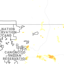
Hail Map for Ute Park, NM
The Ute Park, NM area has had 1 report of on-the-ground hail by trained spotters, and has been under severe weather warnings 10 times during the past 12 months. Doppler radar has detected hail at or near Ute Park, NM on 25 occasions, including 6 occasions during the past year.
| Name: | Ute Park, NM |
| Where Located: | 27.9 miles ENE of Taos, NM |
| Map: | Google Map for Ute Park, NM |
| Population: | 71 |
| Housing Units: | 196 |
| More Info: | Search Google for Ute Park, NM |
1
The Top Recent Hail Date for Ute Park, NM is Tuesday, July 9, 2024 (4th out of 25)

Hail and Wind Damage Spotted near Ute Park, NM
| Date / Time | Report Details |
|---|---|
| 7/18/2024 2:46 PM MDT |
 the severe thunderstorm warning has been cancelled and is no longer in effect the severe thunderstorm warning has been cancelled and is no longer in effect
|
| 7/18/2024 2:29 PM MDT |
 At 229 pm mdt, a severe thunderstorm was located over cimarron canyon state park, or 23 miles northeast of taos, moving south at 15 mph (radar indicated). Hazards include 60 mph wind gusts and quarter size hail. Hail damage to vehicles is expected. expect wind damage to roofs, siding, and trees. locations impacted include, angel fire, eagle nest, cimarron canyon state park, eagle nest lake state park, elizabethtown, vietnam veterans memorial state park, and ute park. this includes the following highways, highway 64 between mile markers 268 and 298. State road 434 between mile markers 31 and 36. At 229 pm mdt, a severe thunderstorm was located over cimarron canyon state park, or 23 miles northeast of taos, moving south at 15 mph (radar indicated). Hazards include 60 mph wind gusts and quarter size hail. Hail damage to vehicles is expected. expect wind damage to roofs, siding, and trees. locations impacted include, angel fire, eagle nest, cimarron canyon state park, eagle nest lake state park, elizabethtown, vietnam veterans memorial state park, and ute park. this includes the following highways, highway 64 between mile markers 268 and 298. State road 434 between mile markers 31 and 36.
|
| 7/18/2024 2:23 PM MDT |
 Svrabq the national weather service in albuquerque has issued a * severe thunderstorm warning for, east central taos county in north central new mexico, southwestern colfax county in northeastern new mexico, * until 315 pm mdt. * at 222 pm mdt, a severe thunderstorm was located near eagle nest, or 23 miles east of questa, moving south at 15 mph (radar indicated). Hazards include ping pong ball size hail and 60 mph wind gusts. People and animals outdoors will be injured. expect hail damage to roofs, siding, windows, and vehicles. Expect wind damage to roofs, siding, and trees. Svrabq the national weather service in albuquerque has issued a * severe thunderstorm warning for, east central taos county in north central new mexico, southwestern colfax county in northeastern new mexico, * until 315 pm mdt. * at 222 pm mdt, a severe thunderstorm was located near eagle nest, or 23 miles east of questa, moving south at 15 mph (radar indicated). Hazards include ping pong ball size hail and 60 mph wind gusts. People and animals outdoors will be injured. expect hail damage to roofs, siding, windows, and vehicles. Expect wind damage to roofs, siding, and trees.
|
| 7/9/2024 3:22 PM MDT |
 the severe thunderstorm warning has been cancelled and is no longer in effect the severe thunderstorm warning has been cancelled and is no longer in effect
|
| 7/9/2024 3:14 PM MDT |
 At 314 pm mdt, a severe thunderstorm was located near ute park, or 26 miles northwest of springer, moving south at 15 mph (radar indicated). Hazards include 60 mph wind gusts and quarter size hail. Hail damage to vehicles is expected. expect wind damage to roofs, siding, and trees. locations impacted include, cimarron, cimarron canyon state park, ute park, philmont scout ranch, and rayado. This includes highway 64 between mile markers 291 and 311. At 314 pm mdt, a severe thunderstorm was located near ute park, or 26 miles northwest of springer, moving south at 15 mph (radar indicated). Hazards include 60 mph wind gusts and quarter size hail. Hail damage to vehicles is expected. expect wind damage to roofs, siding, and trees. locations impacted include, cimarron, cimarron canyon state park, ute park, philmont scout ranch, and rayado. This includes highway 64 between mile markers 291 and 311.
|
| 7/9/2024 3:03 PM MDT |
 Svrabq the national weather service in albuquerque has issued a * severe thunderstorm warning for, southwestern colfax county in northeastern new mexico, * until 345 pm mdt. * at 302 pm mdt, a severe thunderstorm was located near ute park, or 27 miles northwest of springer, moving south at 15 mph (radar indicated). Hazards include 60 mph wind gusts and quarter size hail. Hail damage to vehicles is expected. Expect wind damage to roofs, siding, and trees. Svrabq the national weather service in albuquerque has issued a * severe thunderstorm warning for, southwestern colfax county in northeastern new mexico, * until 345 pm mdt. * at 302 pm mdt, a severe thunderstorm was located near ute park, or 27 miles northwest of springer, moving south at 15 mph (radar indicated). Hazards include 60 mph wind gusts and quarter size hail. Hail damage to vehicles is expected. Expect wind damage to roofs, siding, and trees.
|
| 7/9/2024 3:01 PM MDT | Quarter sized hail reported 1.6 miles SW of Ute Park, NM, report from mping: quarter (1.00 in.). |
| 7/8/2024 1:01 PM MDT |
 Svrabq the national weather service in albuquerque has issued a * severe thunderstorm warning for, north central mora county in northeastern new mexico, southwestern colfax county in northeastern new mexico, * until 145 pm mdt. * at 100 pm mdt, a severe thunderstorm was located near philmont scout ranch, or 24 miles west of springer, moving south at 15 mph (radar indicated). Hazards include 60 mph wind gusts and quarter size hail. Hail damage to vehicles is expected. Expect wind damage to roofs, siding, and trees. Svrabq the national weather service in albuquerque has issued a * severe thunderstorm warning for, north central mora county in northeastern new mexico, southwestern colfax county in northeastern new mexico, * until 145 pm mdt. * at 100 pm mdt, a severe thunderstorm was located near philmont scout ranch, or 24 miles west of springer, moving south at 15 mph (radar indicated). Hazards include 60 mph wind gusts and quarter size hail. Hail damage to vehicles is expected. Expect wind damage to roofs, siding, and trees.
|
| 7/5/2024 3:49 PM MDT |
 the severe thunderstorm warning has been cancelled and is no longer in effect the severe thunderstorm warning has been cancelled and is no longer in effect
|
| 7/5/2024 3:43 PM MDT |
 At 343 pm mdt, a severe thunderstorm was located 8 miles northeast of ute park, or 30 miles northwest of springer, moving south at 15 mph (radar indicated). Hazards include 60 mph wind gusts. Expect damage to roofs, siding, and trees. Locations impacted include, cimarron, eagle nest, cimarron canyon state park, and ute park. At 343 pm mdt, a severe thunderstorm was located 8 miles northeast of ute park, or 30 miles northwest of springer, moving south at 15 mph (radar indicated). Hazards include 60 mph wind gusts. Expect damage to roofs, siding, and trees. Locations impacted include, cimarron, eagle nest, cimarron canyon state park, and ute park.
|
| 7/5/2024 3:21 PM MDT |
 Svrabq the national weather service in albuquerque has issued a * severe thunderstorm warning for, west central colfax county in northeastern new mexico, * until 400 pm mdt. * at 321 pm mdt, a severe thunderstorm was located 13 miles north of ute park, or 30 miles east of questa, moving south at 10 mph (radar indicated). Hazards include 60 mph wind gusts and quarter size hail. Hail damage to vehicles is expected. Expect wind damage to roofs, siding, and trees. Svrabq the national weather service in albuquerque has issued a * severe thunderstorm warning for, west central colfax county in northeastern new mexico, * until 400 pm mdt. * at 321 pm mdt, a severe thunderstorm was located 13 miles north of ute park, or 30 miles east of questa, moving south at 10 mph (radar indicated). Hazards include 60 mph wind gusts and quarter size hail. Hail damage to vehicles is expected. Expect wind damage to roofs, siding, and trees.
|
| 6/8/2022 6:50 PM MDT |
 At 650 pm mdt, a severe thunderstorm was located near ute park, or 28 miles northwest of springer, moving northeast at 15 mph (public). Hazards include 60 mph wind gusts and quarter size hail. Hail damage to vehicles is expected. expect wind damage to roofs, siding, and trees. locations impacted include, cimarron, cimarron canyon state park, ute park and philmont scout ranch. this includes highway 64 between mile markers 291 and 317. hail threat, radar indicated max hail size, 1. 00 in wind threat, radar indicated max wind gust, 60 mph. At 650 pm mdt, a severe thunderstorm was located near ute park, or 28 miles northwest of springer, moving northeast at 15 mph (public). Hazards include 60 mph wind gusts and quarter size hail. Hail damage to vehicles is expected. expect wind damage to roofs, siding, and trees. locations impacted include, cimarron, cimarron canyon state park, ute park and philmont scout ranch. this includes highway 64 between mile markers 291 and 317. hail threat, radar indicated max hail size, 1. 00 in wind threat, radar indicated max wind gust, 60 mph.
|
| 6/8/2022 6:31 PM MDT |
 At 631 pm mdt, a severe thunderstorm was located over ute park, or 27 miles east of taos, moving northeast at 15 mph (public). Hazards include 60 mph wind gusts and half dollar size hail. Hail damage to vehicles is expected. Expect wind damage to roofs, siding, and trees. At 631 pm mdt, a severe thunderstorm was located over ute park, or 27 miles east of taos, moving northeast at 15 mph (public). Hazards include 60 mph wind gusts and half dollar size hail. Hail damage to vehicles is expected. Expect wind damage to roofs, siding, and trees.
|
| 5/22/2021 5:15 PM MDT |
 At 515 pm mdt, a severe thunderstorm was located near philmont scout ranch, or 21 miles west of springer, moving northeast at 35 mph (radar indicated). Hazards include 60 mph wind gusts and quarter size hail. Hail damage to vehicles is expected. Expect wind damage to roofs, siding, and trees. At 515 pm mdt, a severe thunderstorm was located near philmont scout ranch, or 21 miles west of springer, moving northeast at 35 mph (radar indicated). Hazards include 60 mph wind gusts and quarter size hail. Hail damage to vehicles is expected. Expect wind damage to roofs, siding, and trees.
|
| 5/16/2021 6:38 PM MDT |
 At 638 pm mdt, a severe thunderstorm was located over ute park, or 28 miles east of questa, moving northeast at 15 mph (radar indicated). Hazards include 60 mph wind gusts and quarter size hail. Hail damage to vehicles is expected. Expect wind damage to roofs, siding, and trees. At 638 pm mdt, a severe thunderstorm was located over ute park, or 28 miles east of questa, moving northeast at 15 mph (radar indicated). Hazards include 60 mph wind gusts and quarter size hail. Hail damage to vehicles is expected. Expect wind damage to roofs, siding, and trees.
|
| 8/18/2018 1:59 PM MDT |
 The national weather service in albuquerque has issued a * severe thunderstorm warning for. east central taos county in north central new mexico. southwestern colfax county in northeastern new mexico. until 245 pm mdt. At 159 pm mdt, a severe thunderstorm was located near questa,. The national weather service in albuquerque has issued a * severe thunderstorm warning for. east central taos county in north central new mexico. southwestern colfax county in northeastern new mexico. until 245 pm mdt. At 159 pm mdt, a severe thunderstorm was located near questa,.
|
| 8/8/2018 3:57 PM MDT |
 At 356 pm mdt, a severe thunderstorm was located over cimarron canyon state park, or 24 miles northeast of taos, moving south at 15 mph (radar indicated). Hazards include 70 mph wind gusts and ping pong ball size hail. People and animals outdoors will be injured. expect hail damage to roofs, siding, windows, and vehicles. expect considerable tree damage. wind damage is also likely to mobile homes, roofs, and outbuildings. Locations impacted include, angel fire, eagle nest, cimarron canyon state park, vietnam veterans memorial state park, eagle nest lake state park and ute park. At 356 pm mdt, a severe thunderstorm was located over cimarron canyon state park, or 24 miles northeast of taos, moving south at 15 mph (radar indicated). Hazards include 70 mph wind gusts and ping pong ball size hail. People and animals outdoors will be injured. expect hail damage to roofs, siding, windows, and vehicles. expect considerable tree damage. wind damage is also likely to mobile homes, roofs, and outbuildings. Locations impacted include, angel fire, eagle nest, cimarron canyon state park, vietnam veterans memorial state park, eagle nest lake state park and ute park.
|
| 8/8/2018 3:34 PM MDT |
 At 333 pm mdt, a severe thunderstorm was located near ute park, or 25 miles east of questa, moving south at 15 mph (radar indicated). Hazards include 70 mph wind gusts and ping pong ball size hail. People and animals outdoors will be injured. expect hail damage to roofs, siding, windows, and vehicles. expect considerable tree damage. Wind damage is also likely to mobile homes, roofs, and outbuildings. At 333 pm mdt, a severe thunderstorm was located near ute park, or 25 miles east of questa, moving south at 15 mph (radar indicated). Hazards include 70 mph wind gusts and ping pong ball size hail. People and animals outdoors will be injured. expect hail damage to roofs, siding, windows, and vehicles. expect considerable tree damage. Wind damage is also likely to mobile homes, roofs, and outbuildings.
|
| 8/6/2018 3:23 PM MDT |
 At 323 pm mdt, a severe thunderstorm was located 7 miles northeast of ute park, or 30 miles northwest of springer, moving southeast at 5 mph (radar indicated). Hazards include 60 mph wind gusts and half dollar size hail. Hail damage to vehicles is expected. Expect wind damage to roofs, siding, and trees. At 323 pm mdt, a severe thunderstorm was located 7 miles northeast of ute park, or 30 miles northwest of springer, moving southeast at 5 mph (radar indicated). Hazards include 60 mph wind gusts and half dollar size hail. Hail damage to vehicles is expected. Expect wind damage to roofs, siding, and trees.
|
| 7/24/2018 4:52 PM MDT |
 At 452 pm mdt, a severe thunderstorm was located near philmont scout ranch, or 25 miles west of springer, moving southeast at 10 mph (radar indicated). Hazards include 60 mph wind gusts and half dollar size hail. Hail damage to vehicles is expected. Expect wind damage to roofs, siding, and trees. At 452 pm mdt, a severe thunderstorm was located near philmont scout ranch, or 25 miles west of springer, moving southeast at 10 mph (radar indicated). Hazards include 60 mph wind gusts and half dollar size hail. Hail damage to vehicles is expected. Expect wind damage to roofs, siding, and trees.
|
| 6/16/2015 3:58 PM MDT |
 At 357 pm mdt, a severe thunderstorm was located 7 miles northeast of ute park, or 30 miles northwest of springer, moving southeast at 15 mph (radar indicated and observed by the public when the storm crossed west of vermejo park). Hazards include half dollar size hail and 60 mph wind gusts. Hail damage to vehicles is expected. Expect wind damage to roofs, siding and trees. At 357 pm mdt, a severe thunderstorm was located 7 miles northeast of ute park, or 30 miles northwest of springer, moving southeast at 15 mph (radar indicated and observed by the public when the storm crossed west of vermejo park). Hazards include half dollar size hail and 60 mph wind gusts. Hail damage to vehicles is expected. Expect wind damage to roofs, siding and trees.
|
| 5/30/2015 7:22 PM MDT | The severe thunderstorm warning for western colfax county will expire at 730 pm mdt, the storm which prompted the warning has weakened below severe limits, and no longer pose an immediate threat to life or property. therefore the warning will be allowed to expire. however gusty winds and heavy rain are still possible with this thunderstorm. |
| 5/30/2015 6:47 PM MDT | At 646 pm mdt, a severe thunderstorm was located 12 miles north of ute park, or 29 miles east of questa, moving southwest between 10 and 15 mph (radar indicated). Hazards include quarter size hail and 70 mph wind gusts. Hail damage to vehicles is expected. expect considerable tree damage. Wind damage is also likely to mobile homes, roofs and outbuildings. |
Hail Maps for Ute Park, NM


Connect with Interactive Hail Maps