

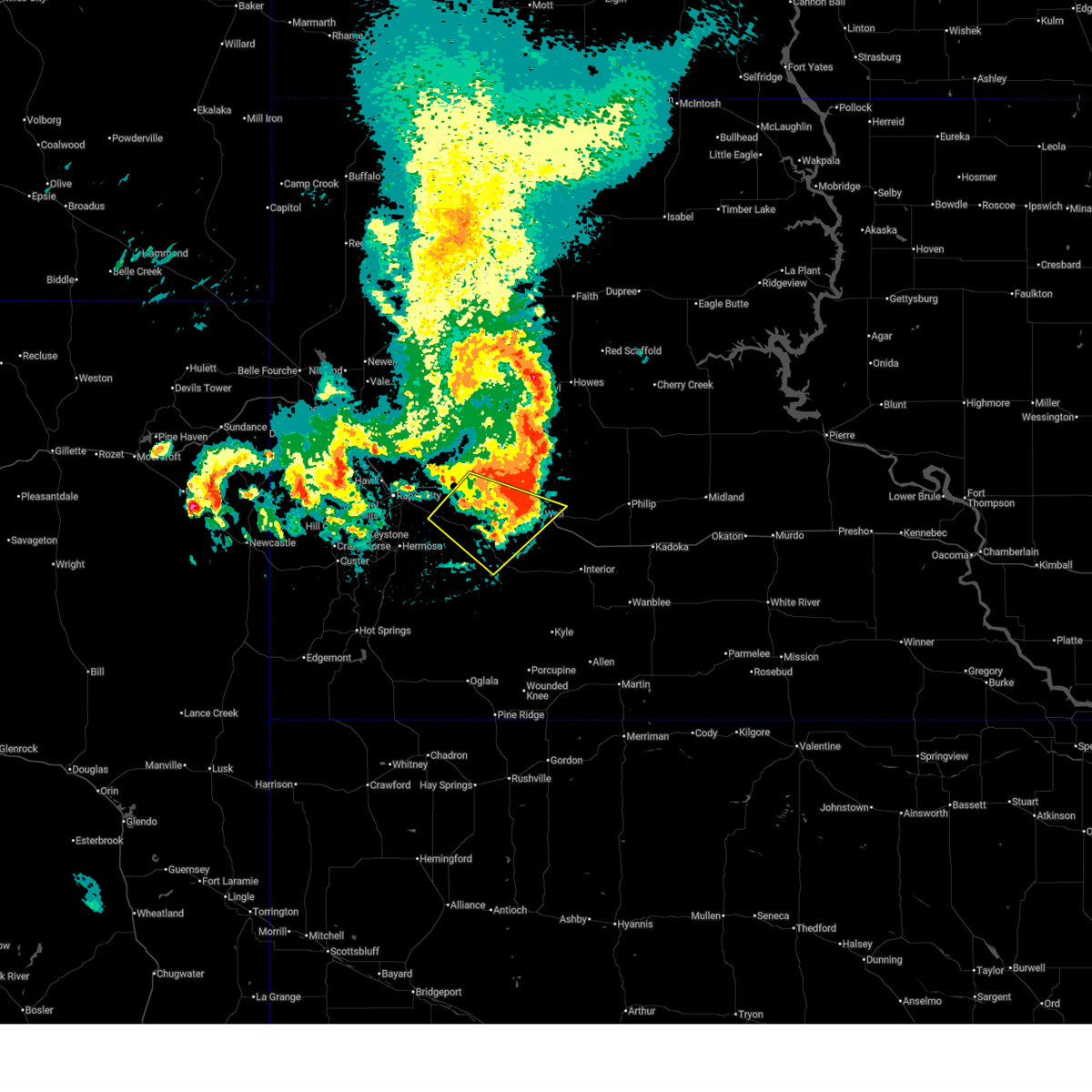
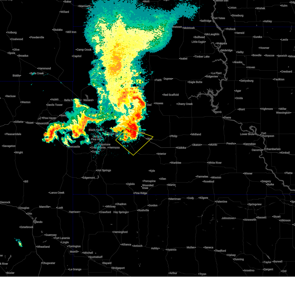
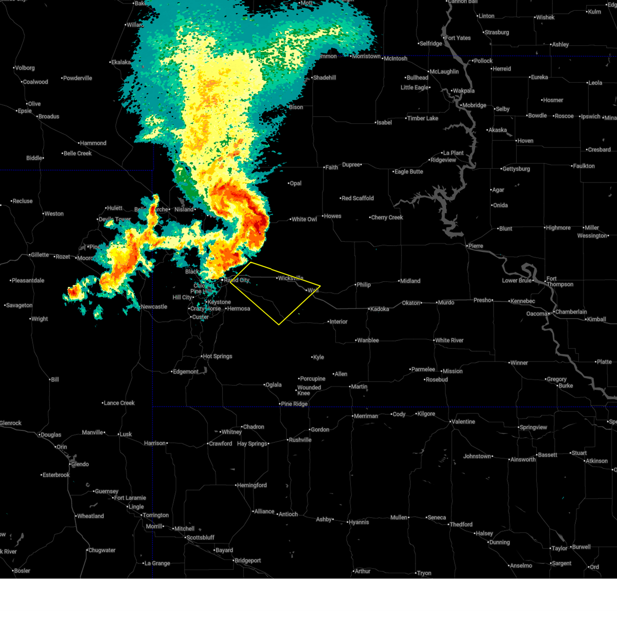
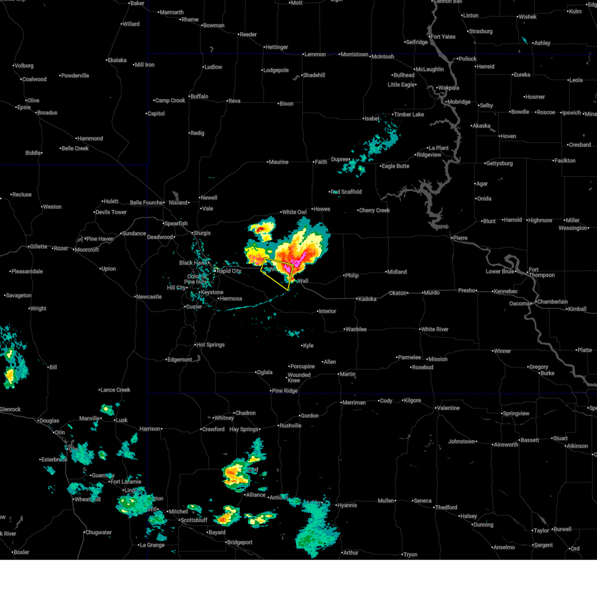
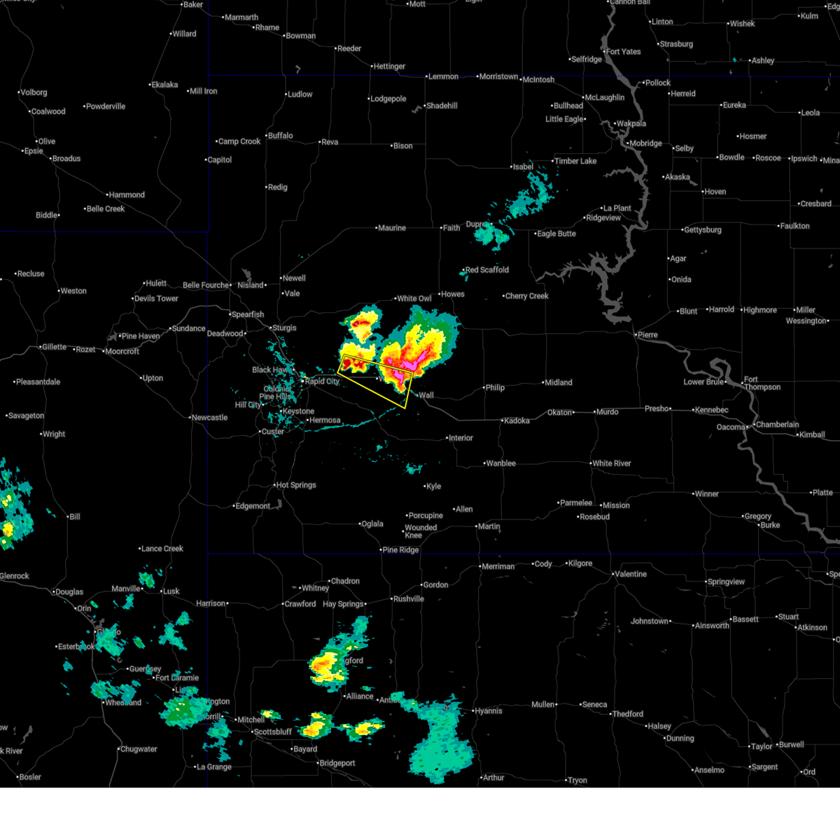
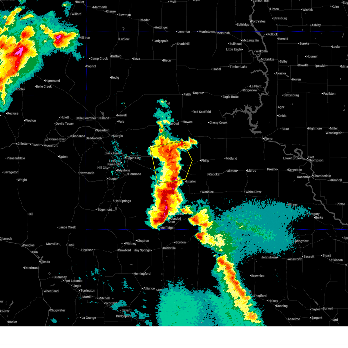
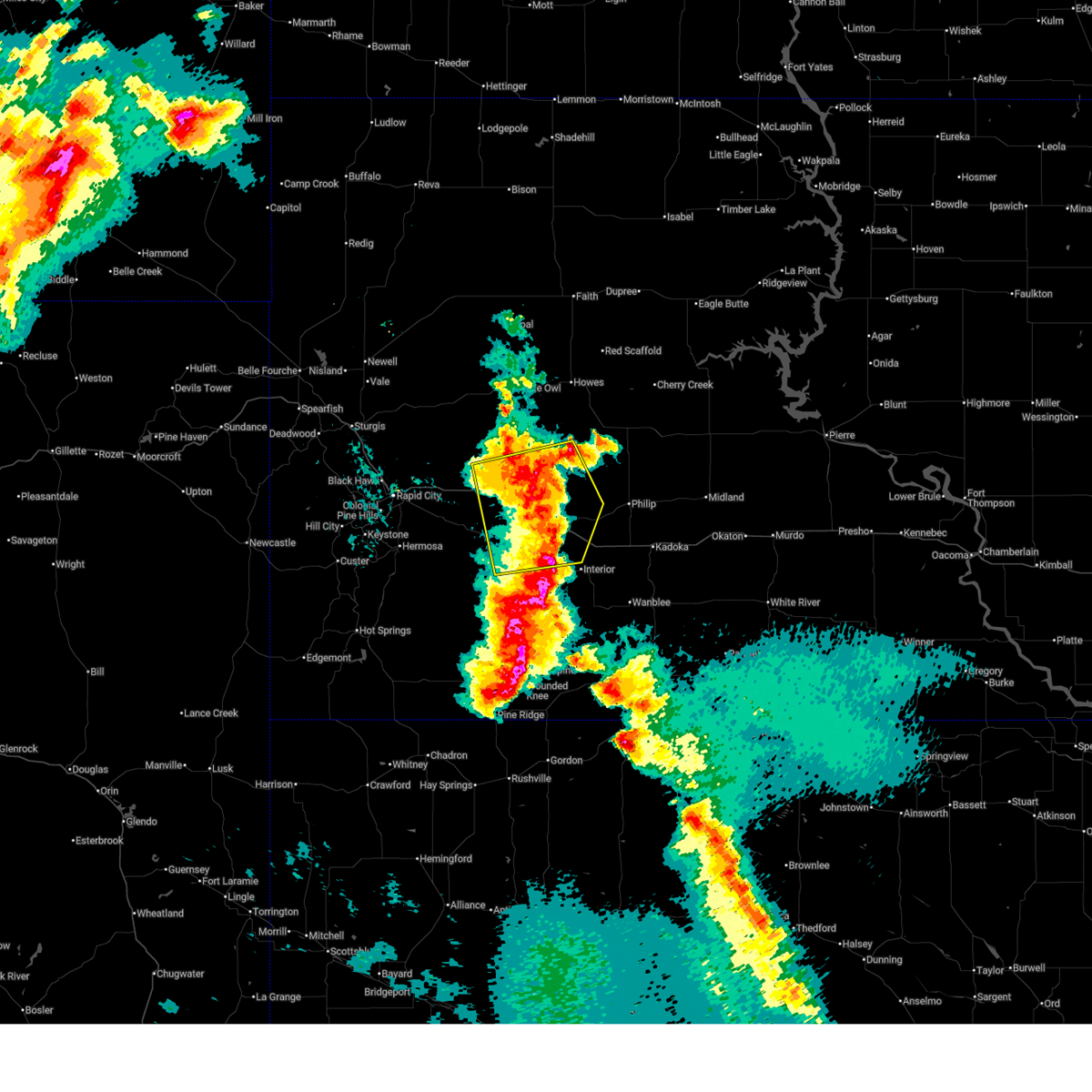
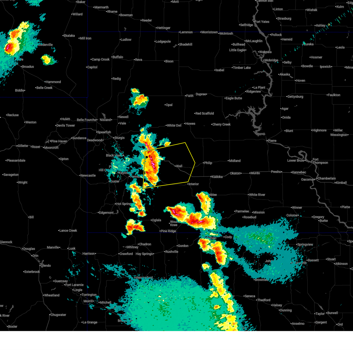
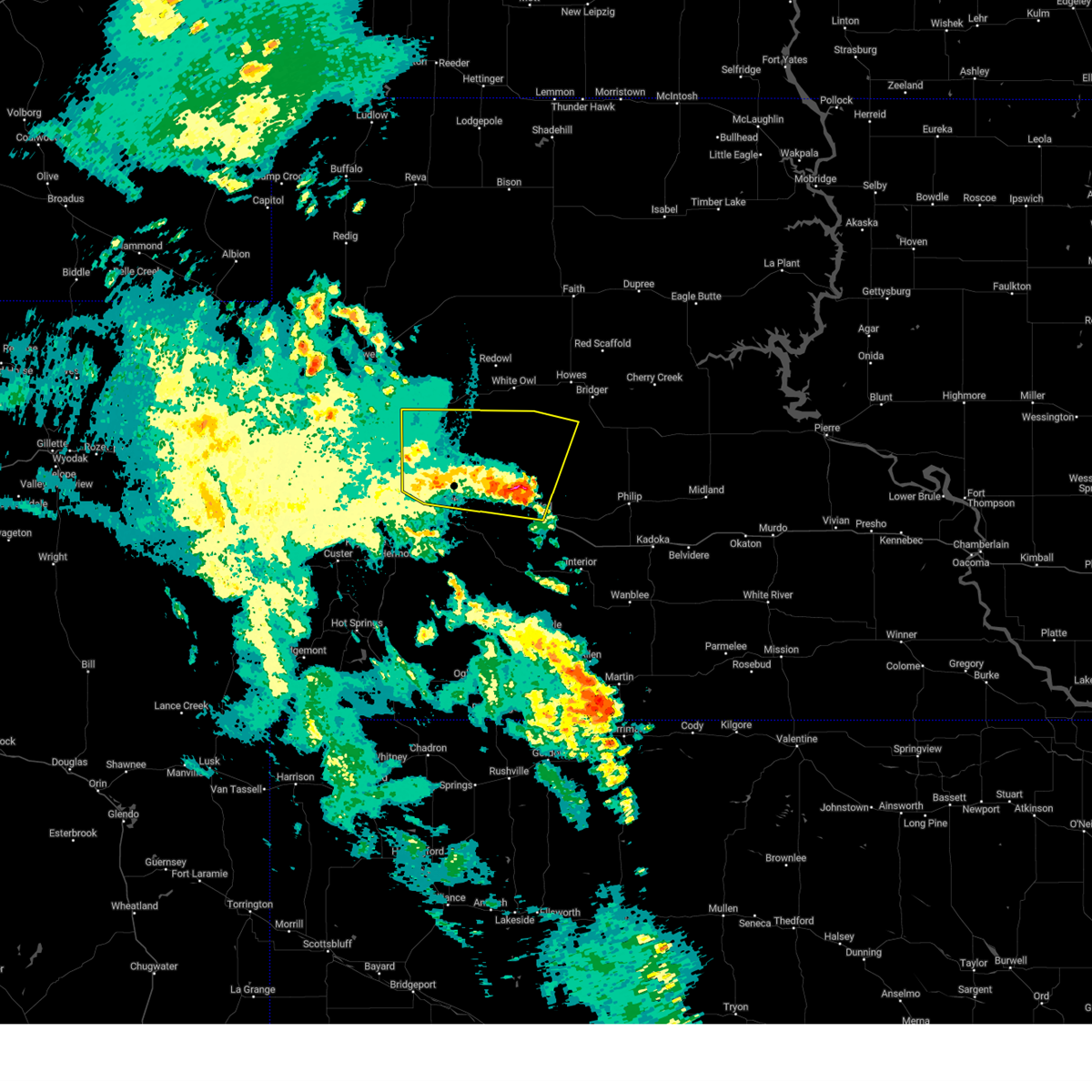
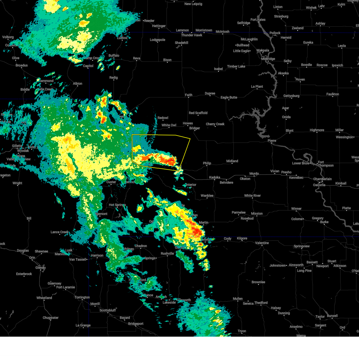
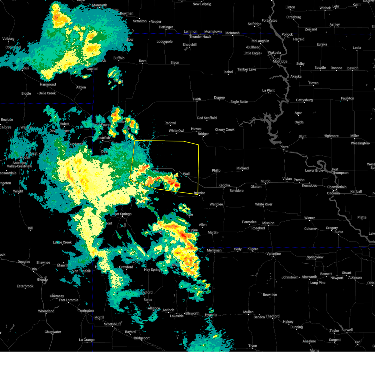
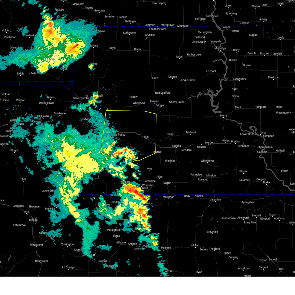
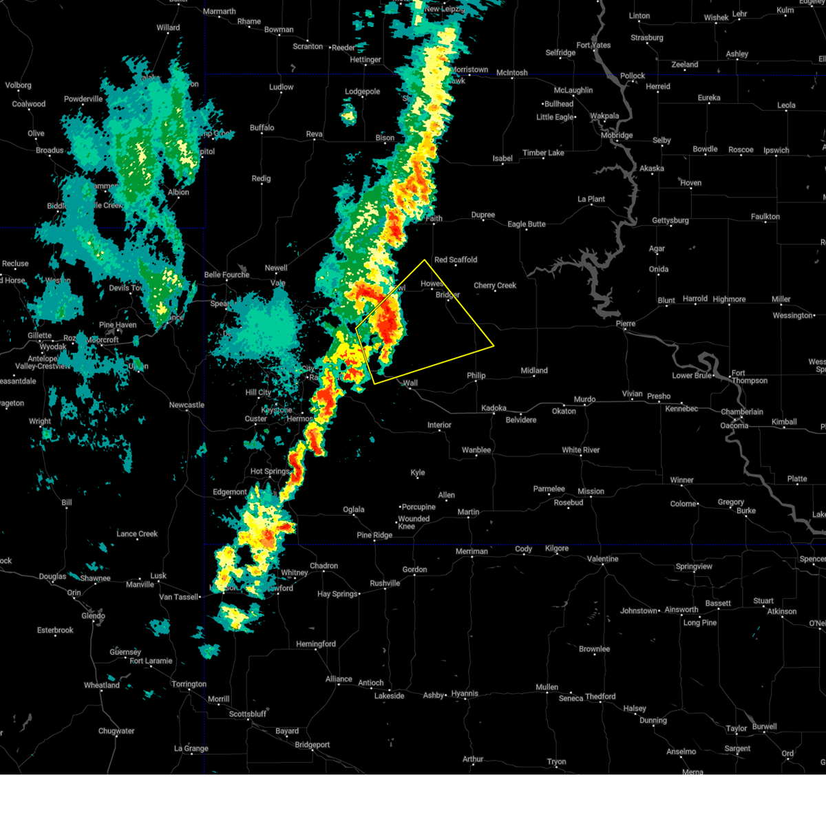
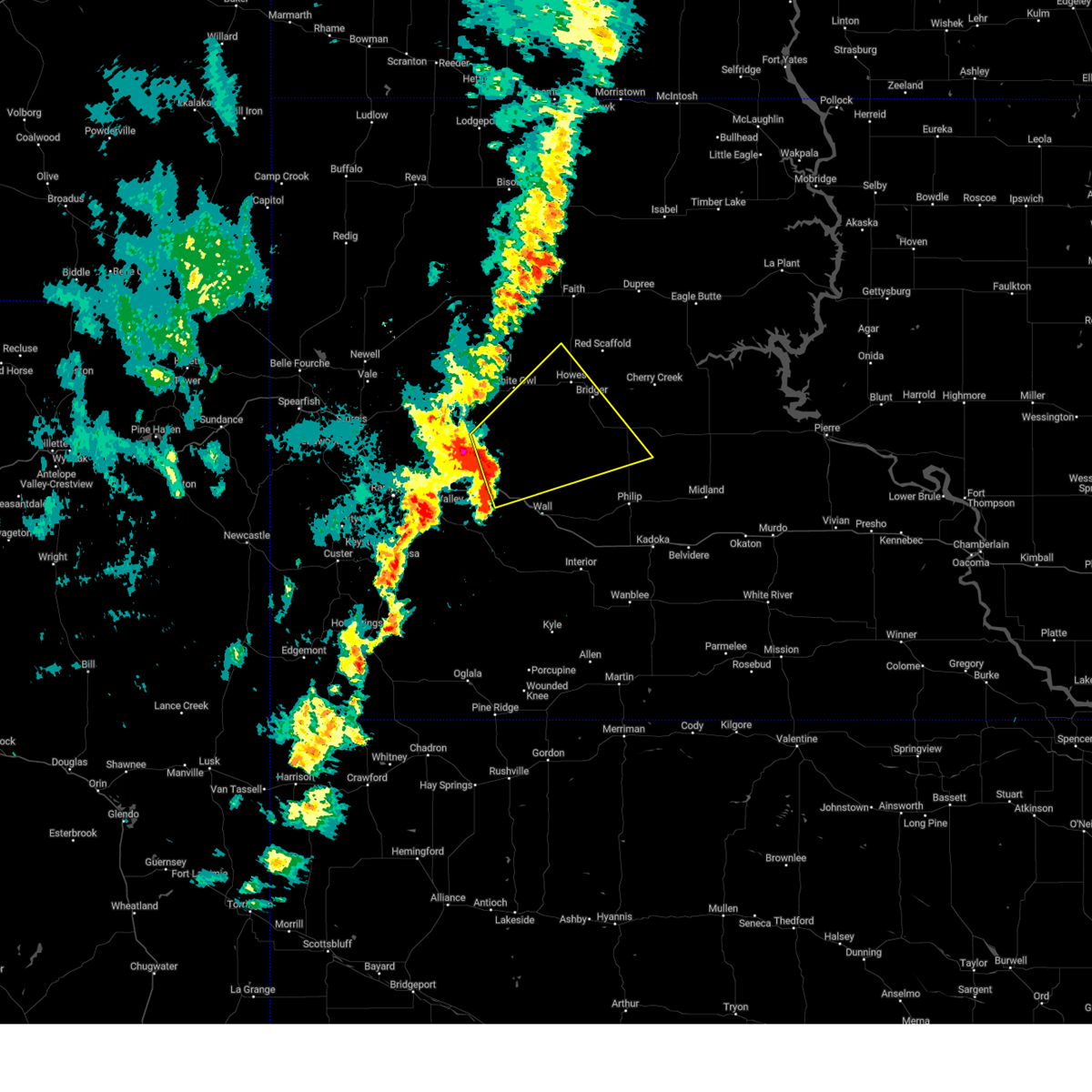
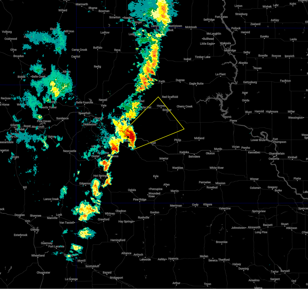
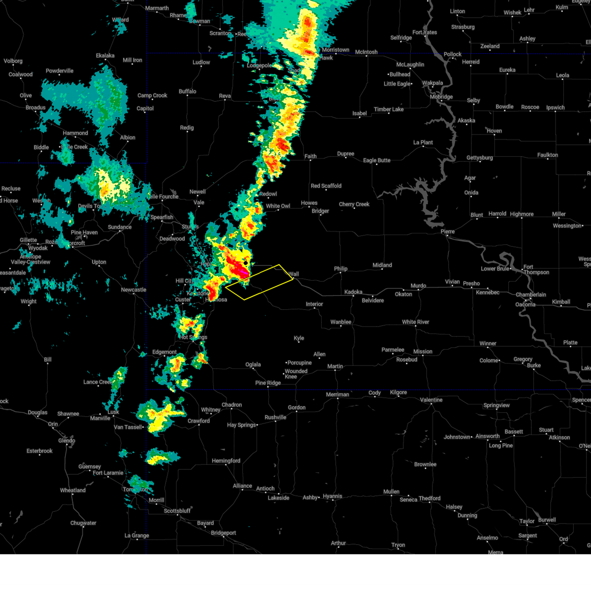
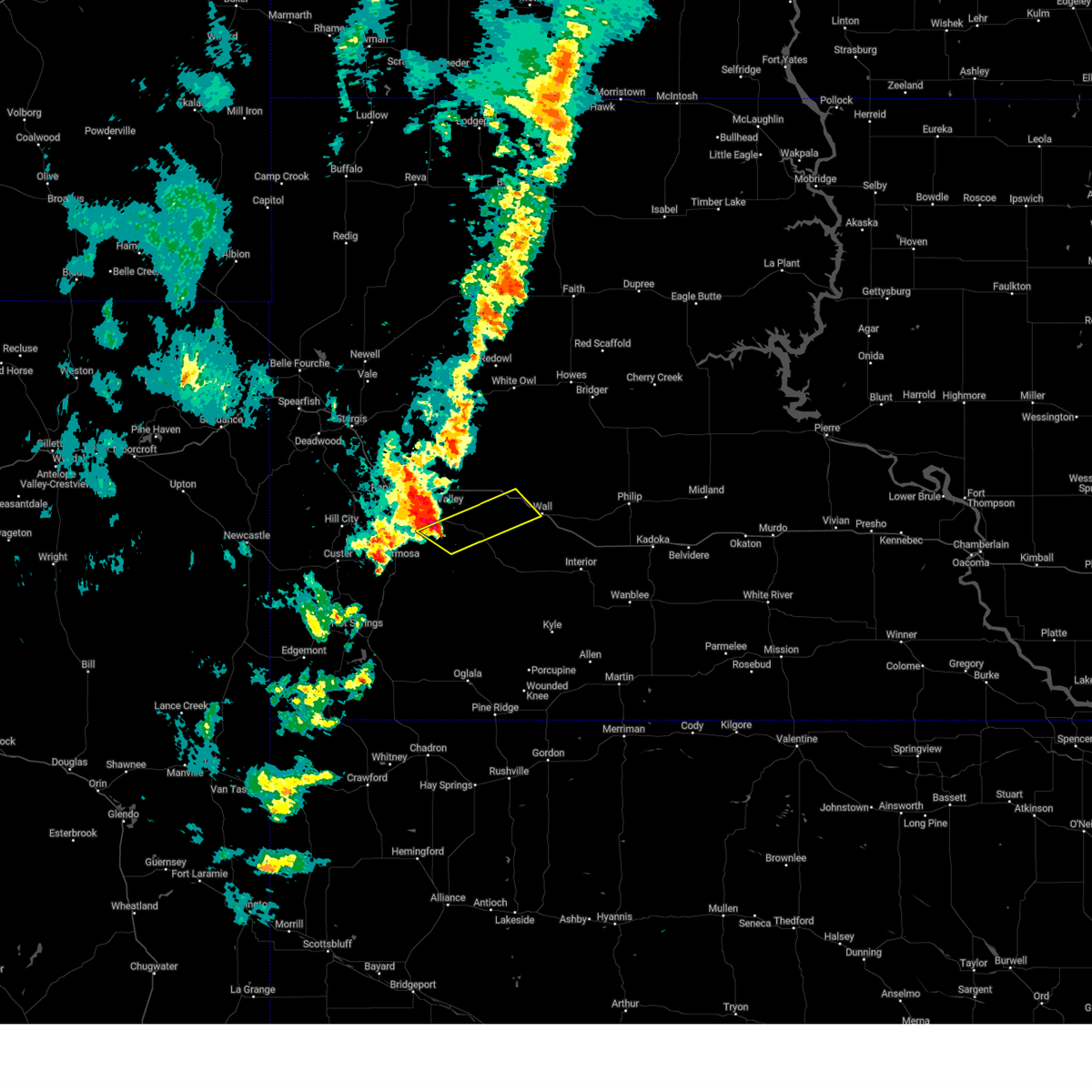
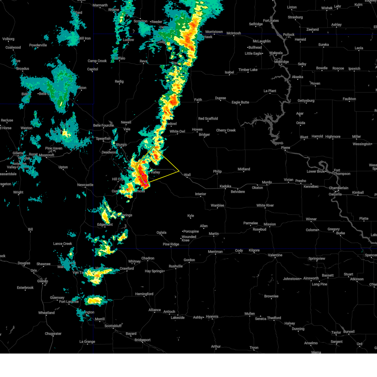
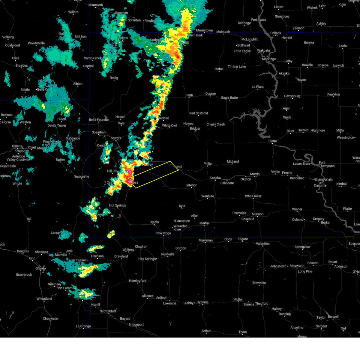
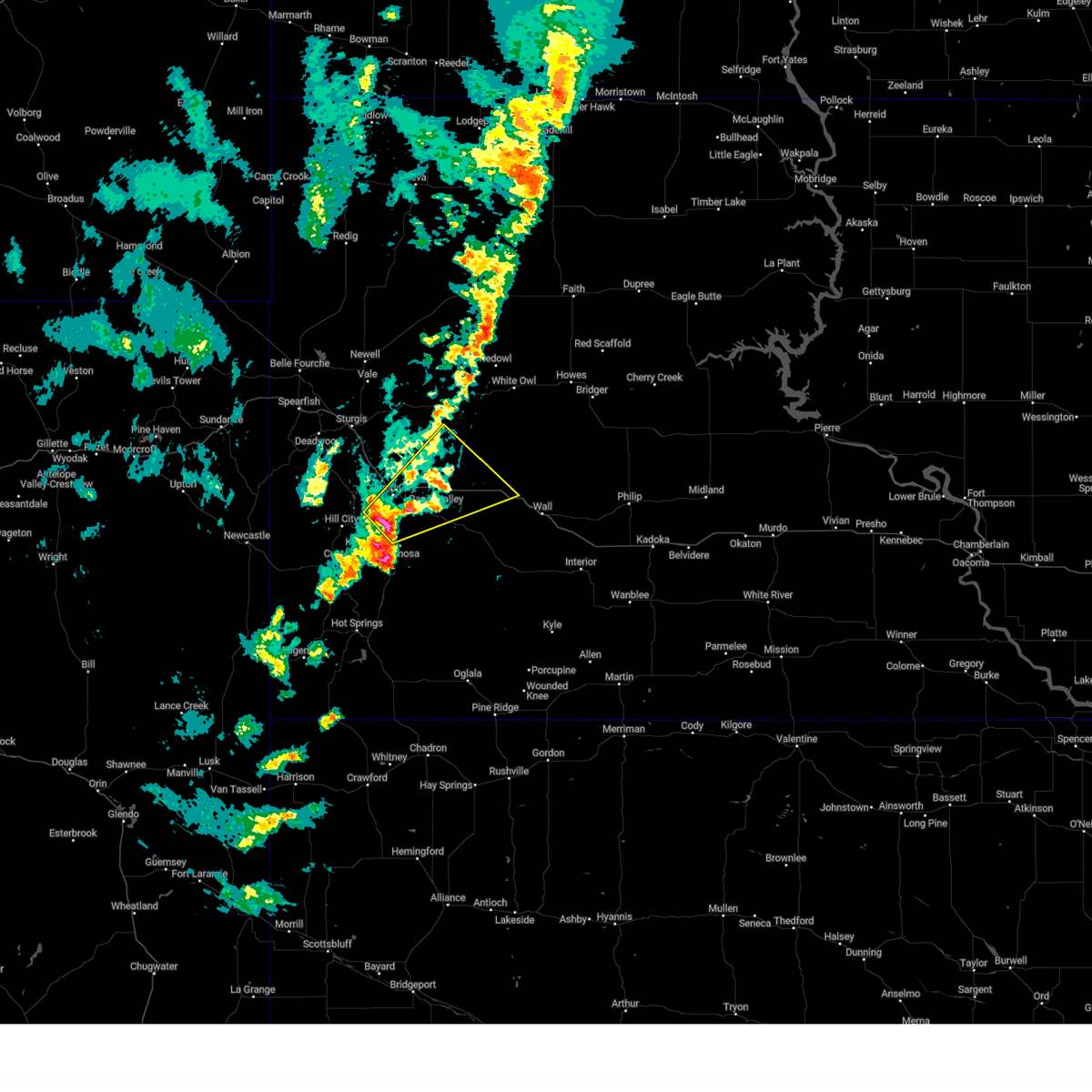
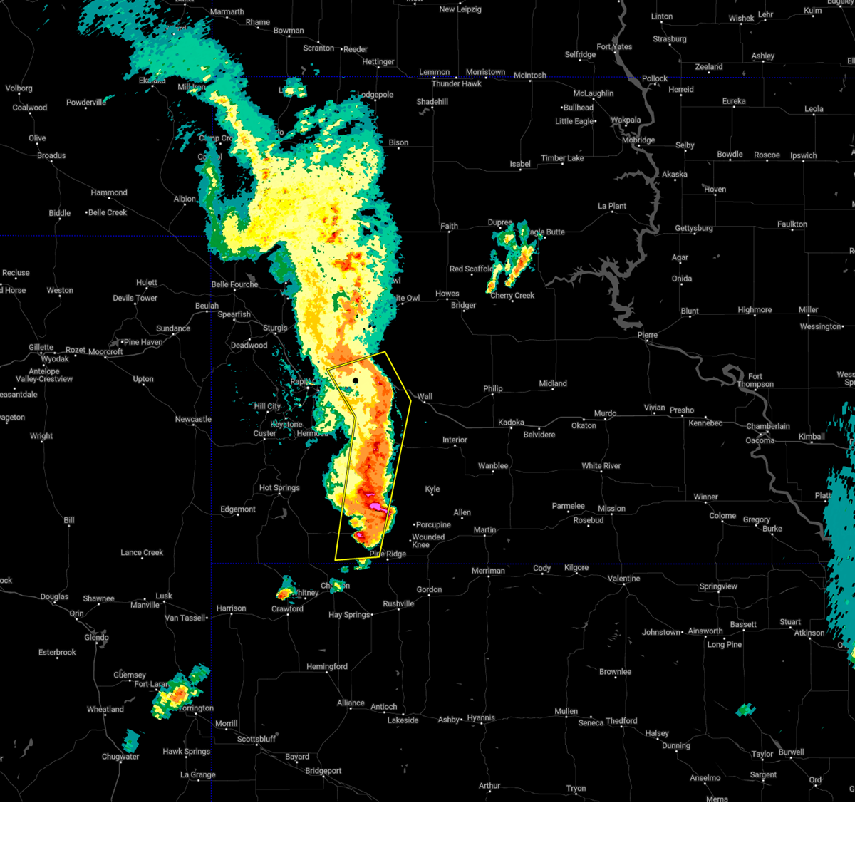
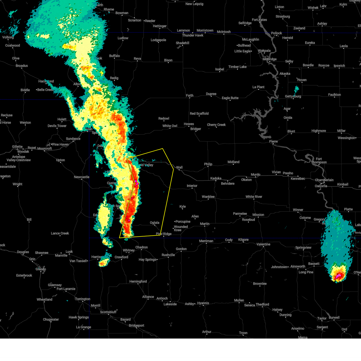
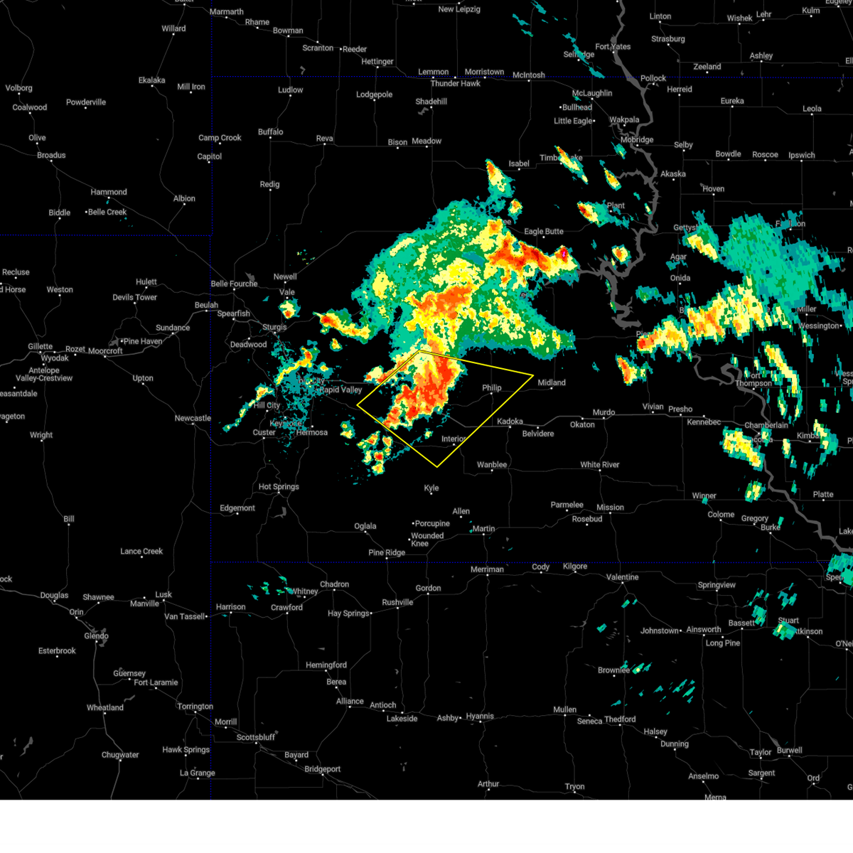
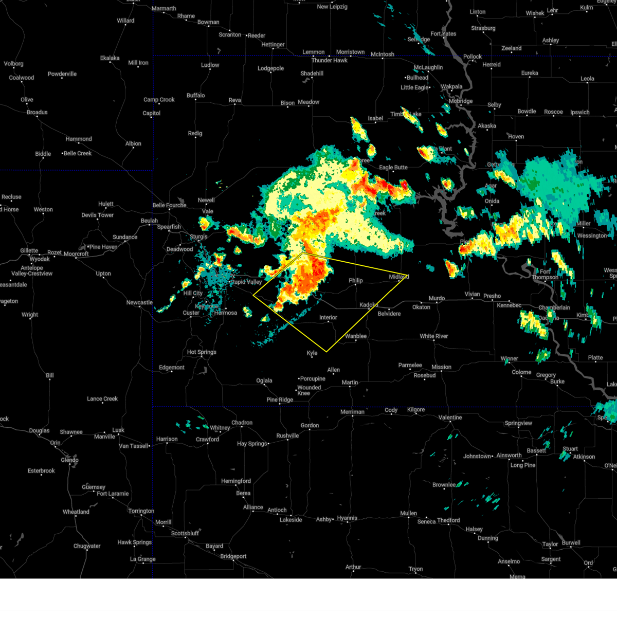
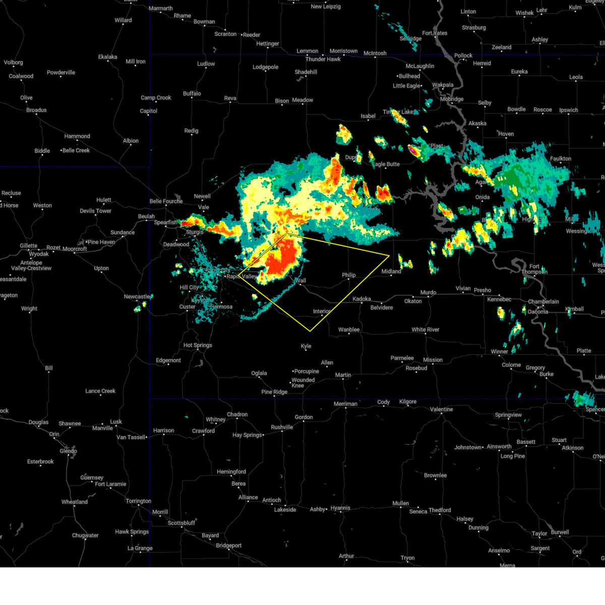
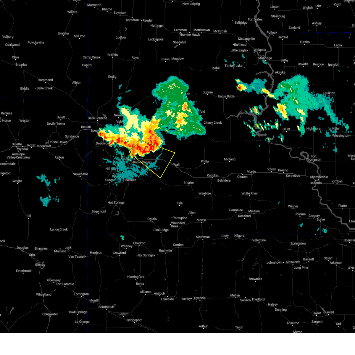
Hail Map for Wasta, SD
The Wasta, SD area has had 27 reports of on-the-ground hail by trained spotters, and has been under severe weather warnings 35 times during the past 12 months. Doppler radar has detected hail at or near Wasta, SD on 72 occasions, including 6 occasions during the past year.
| Name: | Wasta, SD |
| Where Located: | 39 miles E of Rapid City, SD |
| Map: | Google Map for Wasta, SD |
| Population: | 80 |
| Housing Units: | 46 |
| More Info: | Search Google for Wasta, SD |
1
The Top Recent Hail Date for Wasta, SD is Tuesday, September 17, 2024 (21st out of 72)

Hail and Wind Damage Spotted near Wasta, SD
| Date / Time | Report Details |
|---|---|
| 7/10/2025 9:56 AM MDT | Storm damage reported in pennington county SD, 3.4 miles SE of Wasta, SD |
| 7/5/2025 9:58 PM MDT |
 The storms which prompted the warning have weakened below severe limits, and no longer pose an immediate threat to life or property. therefore, the warning will be allowed to expire. however, gusty winds to around 55 mph and heavy rain are still possible with these thunderstorms for the next hour. a severe thunderstorm watch remains in effect until 100 am mdt for southwestern and west central south dakota. The storms which prompted the warning have weakened below severe limits, and no longer pose an immediate threat to life or property. therefore, the warning will be allowed to expire. however, gusty winds to around 55 mph and heavy rain are still possible with these thunderstorms for the next hour. a severe thunderstorm watch remains in effect until 100 am mdt for southwestern and west central south dakota.
|
| 7/5/2025 9:50 PM MDT | Storm damage reported in pennington county SD, 3.4 miles SE of Wasta, SD |
| 7/5/2025 9:45 PM MDT | Storm damage reported in pennington county SD, 0.2 miles SE of Wasta, SD |
| 7/5/2025 9:41 PM MDT |
 At 941 pm mdt, severe thunderstorms were located along a line extending from 4 miles east of wasta to 4 miles northwest of scenic, moving southeast at 35 mph (radar indicated). Hazards include 60 mph wind gusts. Expect damage to roofs, siding, and trees. locations impacted include, wall, new underwood, wasta, scenic, owanka, farmingdale, wicksville, railroad buttes, sheep mountain table, and northern badlands national park. This includes interstate 90 in south dakota between mile markers 78 and 114. At 941 pm mdt, severe thunderstorms were located along a line extending from 4 miles east of wasta to 4 miles northwest of scenic, moving southeast at 35 mph (radar indicated). Hazards include 60 mph wind gusts. Expect damage to roofs, siding, and trees. locations impacted include, wall, new underwood, wasta, scenic, owanka, farmingdale, wicksville, railroad buttes, sheep mountain table, and northern badlands national park. This includes interstate 90 in south dakota between mile markers 78 and 114.
|
| 7/5/2025 9:40 PM MDT | Storm damage reported in pennington county SD, 3.4 miles SE of Wasta, SD |
| 7/5/2025 9:05 PM MDT |
 Svrunr the national weather service in rapid city has issued a * severe thunderstorm warning for, south central meade county in west central south dakota, northeastern custer county in southwestern south dakota, southeastern pennington county in west central south dakota, * until 1000 pm mdt. * at 905 pm mdt, severe thunderstorms were located along a line extending from 2 miles southeast of curlew lake to 2 miles east of rapid city airport, moving east at 35 mph (radar indicated). Hazards include 60 mph wind gusts. expect damage to roofs, siding, and trees Svrunr the national weather service in rapid city has issued a * severe thunderstorm warning for, south central meade county in west central south dakota, northeastern custer county in southwestern south dakota, southeastern pennington county in west central south dakota, * until 1000 pm mdt. * at 905 pm mdt, severe thunderstorms were located along a line extending from 2 miles southeast of curlew lake to 2 miles east of rapid city airport, moving east at 35 mph (radar indicated). Hazards include 60 mph wind gusts. expect damage to roofs, siding, and trees
|
| 6/28/2025 5:59 PM MDT |
 At 559 pm mdt, a severe thunderstorm was located over wicksville, or 33 miles east of rapid city, moving east at 40 mph (radar indicated). Hazards include 60 mph wind gusts and quarter size hail. Hail damage to vehicles is expected. expect wind damage to roofs, siding, and trees. locations impacted include, wasta and wicksville. This includes interstate 90 in south dakota between mile markers 87 and 106. At 559 pm mdt, a severe thunderstorm was located over wicksville, or 33 miles east of rapid city, moving east at 40 mph (radar indicated). Hazards include 60 mph wind gusts and quarter size hail. Hail damage to vehicles is expected. expect wind damage to roofs, siding, and trees. locations impacted include, wasta and wicksville. This includes interstate 90 in south dakota between mile markers 87 and 106.
|
| 6/28/2025 5:47 PM MDT |
 At 546 pm mdt, a severe thunderstorm was located 6 miles northeast of new underwood, or 26 miles east of rapid city, moving east at 40 mph (radar indicated). Hazards include 60 mph wind gusts and half dollar size hail. Hail damage to vehicles is expected. expect wind damage to roofs, siding, and trees. locations impacted include, new underwood, wasta, owanka, wicksville, and viewfield. This includes interstate 90 in south dakota between mile markers 77 and 106. At 546 pm mdt, a severe thunderstorm was located 6 miles northeast of new underwood, or 26 miles east of rapid city, moving east at 40 mph (radar indicated). Hazards include 60 mph wind gusts and half dollar size hail. Hail damage to vehicles is expected. expect wind damage to roofs, siding, and trees. locations impacted include, new underwood, wasta, owanka, wicksville, and viewfield. This includes interstate 90 in south dakota between mile markers 77 and 106.
|
| 6/28/2025 5:45 PM MDT | Storm damage reported in pennington county SD, 3.4 miles SE of Wasta, SD |
| 6/28/2025 5:38 PM MDT |
 At 538 pm mdt, a severe thunderstorm was located 5 miles north of wasta, or 39 miles east of rapid city, moving east at 35 mph (radar indicated). Hazards include golf ball size hail and 60 mph wind gusts. People and animals outdoors will be injured. expect hail damage to roofs, siding, windows, and vehicles. expect wind damage to roofs, siding, and trees. locations impacted include, wall, wasta, quinn, wicksville, and delta 9 missile silo. This includes interstate 90 in south dakota between mile markers 87 and 124. At 538 pm mdt, a severe thunderstorm was located 5 miles north of wasta, or 39 miles east of rapid city, moving east at 35 mph (radar indicated). Hazards include golf ball size hail and 60 mph wind gusts. People and animals outdoors will be injured. expect hail damage to roofs, siding, windows, and vehicles. expect wind damage to roofs, siding, and trees. locations impacted include, wall, wasta, quinn, wicksville, and delta 9 missile silo. This includes interstate 90 in south dakota between mile markers 87 and 124.
|
| 6/28/2025 5:36 PM MDT |
 Svrunr the national weather service in rapid city has issued a * severe thunderstorm warning for, south central meade county in west central south dakota, east central pennington county in west central south dakota, * until 630 pm mdt. * at 536 pm mdt, a severe thunderstorm was located 3 miles southwest of viewfield, or 19 miles east of rapid city, moving east at 40 mph (radar indicated). Hazards include 60 mph wind gusts and half dollar size hail. Hail damage to vehicles is expected. Expect wind damage to roofs, siding, and trees. Svrunr the national weather service in rapid city has issued a * severe thunderstorm warning for, south central meade county in west central south dakota, east central pennington county in west central south dakota, * until 630 pm mdt. * at 536 pm mdt, a severe thunderstorm was located 3 miles southwest of viewfield, or 19 miles east of rapid city, moving east at 40 mph (radar indicated). Hazards include 60 mph wind gusts and half dollar size hail. Hail damage to vehicles is expected. Expect wind damage to roofs, siding, and trees.
|
| 6/28/2025 5:26 PM MDT |
 Svrunr the national weather service in rapid city has issued a * severe thunderstorm warning for, southeastern meade county in west central south dakota, east central pennington county in west central south dakota, * until 630 pm mdt. * at 525 pm mdt, a severe thunderstorm was located 5 miles north of wicksville, or 32 miles east of rapid city, moving east at 35 mph (radar indicated). Hazards include golf ball size hail and 60 mph wind gusts. People and animals outdoors will be injured. expect hail damage to roofs, siding, windows, and vehicles. Expect wind damage to roofs, siding, and trees. Svrunr the national weather service in rapid city has issued a * severe thunderstorm warning for, southeastern meade county in west central south dakota, east central pennington county in west central south dakota, * until 630 pm mdt. * at 525 pm mdt, a severe thunderstorm was located 5 miles north of wicksville, or 32 miles east of rapid city, moving east at 35 mph (radar indicated). Hazards include golf ball size hail and 60 mph wind gusts. People and animals outdoors will be injured. expect hail damage to roofs, siding, windows, and vehicles. Expect wind damage to roofs, siding, and trees.
|
| 6/28/2025 5:20 PM MDT | Storm damage reported in meade county SD, 16.8 miles S of Wasta, SD |
| 6/15/2025 9:48 PM MDT |
 At 948 pm mdt, severe thunderstorms were located along a line extending from near creighton to 2 miles east of quinn to 8 miles southeast of pinnacles ranger station, moving east at 40 mph (radar indicated). Hazards include 70 mph wind gusts and quarter size hail. Hail damage to vehicles is expected. expect considerable tree damage. wind damage is also likely to mobile homes, roofs, and outbuildings. locations impacted include, grindstone, cottonwood, delta 1 launch facility and eastern badlands national park. This includes interstate 90 in south dakota between mile markers 86 and 129. At 948 pm mdt, severe thunderstorms were located along a line extending from near creighton to 2 miles east of quinn to 8 miles southeast of pinnacles ranger station, moving east at 40 mph (radar indicated). Hazards include 70 mph wind gusts and quarter size hail. Hail damage to vehicles is expected. expect considerable tree damage. wind damage is also likely to mobile homes, roofs, and outbuildings. locations impacted include, grindstone, cottonwood, delta 1 launch facility and eastern badlands national park. This includes interstate 90 in south dakota between mile markers 86 and 129.
|
| 6/15/2025 9:48 PM MDT |
 the severe thunderstorm warning has been cancelled and is no longer in effect the severe thunderstorm warning has been cancelled and is no longer in effect
|
| 6/15/2025 9:45 PM MDT | Storm damage reported in pennington county SD, 0.2 miles SE of Wasta, SD |
| 6/15/2025 9:38 PM MDT | Storm damage reported in pennington county SD, 3.4 miles SE of Wasta, SD |
| 6/15/2025 9:35 PM MDT | Storm damage reported in pennington county SD, 0.2 miles SE of Wasta, SD |
| 6/15/2025 9:07 PM MDT |
 Svrunr the national weather service in rapid city has issued a * severe thunderstorm warning for, southwestern haakon county in west central south dakota, south central meade county in west central south dakota, northeastern custer county in southwestern south dakota, northwestern oglala lakota county in southwestern south dakota, northwestern jackson county in southwestern south dakota, southeastern pennington county in west central south dakota, * until 1000 pm mdt. * at 906 pm mdt, severe thunderstorms were located along a line extending from near curlew lake to 2 miles southwest of owanka to 7 miles northwest of sheep mountain table, moving east at 40 mph (radar indicated). Hazards include 70 mph wind gusts and quarter size hail. Hail damage to vehicles is expected. expect considerable tree damage. wind damage is also likely to mobile homes, roofs, and outbuildings. severe thunderstorms will be near, wasta, scenic, owanka, wicksville, sheep mountain table, and northeastern badlands national park around 910 pm mdt. wall around 915 pm mdt. pinnacles ranger station around 920 pm mdt. quinn and delta 9 missile silo around 925 pm mdt. creighton around 930 pm mdt. This includes interstate 90 in south dakota between mile markers 77 and 129. Svrunr the national weather service in rapid city has issued a * severe thunderstorm warning for, southwestern haakon county in west central south dakota, south central meade county in west central south dakota, northeastern custer county in southwestern south dakota, northwestern oglala lakota county in southwestern south dakota, northwestern jackson county in southwestern south dakota, southeastern pennington county in west central south dakota, * until 1000 pm mdt. * at 906 pm mdt, severe thunderstorms were located along a line extending from near curlew lake to 2 miles southwest of owanka to 7 miles northwest of sheep mountain table, moving east at 40 mph (radar indicated). Hazards include 70 mph wind gusts and quarter size hail. Hail damage to vehicles is expected. expect considerable tree damage. wind damage is also likely to mobile homes, roofs, and outbuildings. severe thunderstorms will be near, wasta, scenic, owanka, wicksville, sheep mountain table, and northeastern badlands national park around 910 pm mdt. wall around 915 pm mdt. pinnacles ranger station around 920 pm mdt. quinn and delta 9 missile silo around 925 pm mdt. creighton around 930 pm mdt. This includes interstate 90 in south dakota between mile markers 77 and 129.
|
| 4/8/2025 7:36 PM MDT | Storm damage reported in pennington county SD, 18.4 miles NNE of Wasta, SD |
| 9/17/2024 8:13 PM MDT |
 At 812 pm mdt, severe thunderstorms were located along a line extending from 7 miles west of viewfield to 7 miles north of wicksville to 5 miles north of wall, moving northeast at 50 mph. automated observations along interstate 90 recently recorded wind gusts of 58 mph (automated observations indicated). Hazards include 60 mph wind gusts. Expect damage to roofs, siding, and trees. locations impacted include, northeastern rapid valley, ellsworth air force base, box elder, wall, new underwood, wasta, owanka, elm springs, creighton, hereford, wicksville, curlew lake, viewfield, and rapid city airport. This includes interstate 90 in south dakota between mile markers 61 and 111. At 812 pm mdt, severe thunderstorms were located along a line extending from 7 miles west of viewfield to 7 miles north of wicksville to 5 miles north of wall, moving northeast at 50 mph. automated observations along interstate 90 recently recorded wind gusts of 58 mph (automated observations indicated). Hazards include 60 mph wind gusts. Expect damage to roofs, siding, and trees. locations impacted include, northeastern rapid valley, ellsworth air force base, box elder, wall, new underwood, wasta, owanka, elm springs, creighton, hereford, wicksville, curlew lake, viewfield, and rapid city airport. This includes interstate 90 in south dakota between mile markers 61 and 111.
|
| 9/17/2024 8:13 PM MDT |
 the severe thunderstorm warning has been cancelled and is no longer in effect the severe thunderstorm warning has been cancelled and is no longer in effect
|
| 9/17/2024 8:10 PM MDT | Storm damage reported in pennington county SD, 3.4 miles SE of Wasta, SD |
| 9/17/2024 7:57 PM MDT |
 the severe thunderstorm warning has been cancelled and is no longer in effect the severe thunderstorm warning has been cancelled and is no longer in effect
|
| 9/17/2024 7:57 PM MDT |
 At 756 pm mdt, severe thunderstorms were located along a line extending from rapid valley to 5 miles southeast of new underwood to 5 miles southwest of wall, moving northeast at 40 mph. wind gusts around 60 mph were recently reported at the rapid city regional airport and 2 miles ene of downtown rapid city (trained weather spotters). Hazards include 60 mph wind gusts. Expect damage to roofs, siding, and trees. locations impacted include, northeastern rapid valley, ellsworth air force base, box elder, wall, new underwood, wasta, quinn, owanka, wicksville, curlew lake, elm springs, hereford and creighton. This includes interstate 90 in south dakota between mile markers 54 and 124. At 756 pm mdt, severe thunderstorms were located along a line extending from rapid valley to 5 miles southeast of new underwood to 5 miles southwest of wall, moving northeast at 40 mph. wind gusts around 60 mph were recently reported at the rapid city regional airport and 2 miles ene of downtown rapid city (trained weather spotters). Hazards include 60 mph wind gusts. Expect damage to roofs, siding, and trees. locations impacted include, northeastern rapid valley, ellsworth air force base, box elder, wall, new underwood, wasta, quinn, owanka, wicksville, curlew lake, elm springs, hereford and creighton. This includes interstate 90 in south dakota between mile markers 54 and 124.
|
| 9/17/2024 7:36 PM MDT |
 Svrunr the national weather service in rapid city has issued a * severe thunderstorm warning for, southern meade county in west central south dakota, northeastern custer county in southwestern south dakota, north central oglala lakota county in southwestern south dakota, pennington county in west central south dakota, * until 830 pm mdt. * at 736 pm mdt, severe thunderstorms were located along a line extending from near hayward to 4 miles west of folsom to 3 miles northwest of badlands national park, moving northeast at 50 mph. wind gusts of around 60 mph were recently observed near and east of fairburn (automated observations indicated). Hazards include 60 mph wind gusts. Expect damage to roofs, siding, and trees. severe thunderstorms will be near, rapid city, rapid valley, hermosa, scenic, hayward, caputa, folsom, farmingdale, railroad buttes, and bear country around 740 pm mdt. ellsworth air force base, box elder, new underwood, owanka, and pinnacles ranger station around 745 pm mdt. black hawk, wall, wasta, wicksville, and delta 9 missile silo around 750 pm mdt. quinn around 755 pm mdt. other locations in the path of these severe thunderstorms include curlew lake, viewfield, elm springs and creighton. This includes interstate 90 in south dakota between mile markers 54 and 124. Svrunr the national weather service in rapid city has issued a * severe thunderstorm warning for, southern meade county in west central south dakota, northeastern custer county in southwestern south dakota, north central oglala lakota county in southwestern south dakota, pennington county in west central south dakota, * until 830 pm mdt. * at 736 pm mdt, severe thunderstorms were located along a line extending from near hayward to 4 miles west of folsom to 3 miles northwest of badlands national park, moving northeast at 50 mph. wind gusts of around 60 mph were recently observed near and east of fairburn (automated observations indicated). Hazards include 60 mph wind gusts. Expect damage to roofs, siding, and trees. severe thunderstorms will be near, rapid city, rapid valley, hermosa, scenic, hayward, caputa, folsom, farmingdale, railroad buttes, and bear country around 740 pm mdt. ellsworth air force base, box elder, new underwood, owanka, and pinnacles ranger station around 745 pm mdt. black hawk, wall, wasta, wicksville, and delta 9 missile silo around 750 pm mdt. quinn around 755 pm mdt. other locations in the path of these severe thunderstorms include curlew lake, viewfield, elm springs and creighton. This includes interstate 90 in south dakota between mile markers 54 and 124.
|
| 9/12/2024 8:21 PM MDT |
 the severe thunderstorm warning has been cancelled and is no longer in effect the severe thunderstorm warning has been cancelled and is no longer in effect
|
| 9/12/2024 8:01 PM MDT |
 At 801 pm mdt, a severe thunderstorm was located 5 miles east of elm springs, or 41 miles northwest of philip, moving northeast at 40 mph (radar indicated). Hazards include 60 mph wind gusts. Expect damage to roofs, siding, and trees. locations impacted include, creighton, plainview, bridger and howes. This includes interstate 90 in south dakota between mile markers 90 and 102. At 801 pm mdt, a severe thunderstorm was located 5 miles east of elm springs, or 41 miles northwest of philip, moving northeast at 40 mph (radar indicated). Hazards include 60 mph wind gusts. Expect damage to roofs, siding, and trees. locations impacted include, creighton, plainview, bridger and howes. This includes interstate 90 in south dakota between mile markers 90 and 102.
|
| 9/12/2024 7:47 PM MDT | Storm damage reported in pennington county SD, 3.4 miles SE of Wasta, SD |
| 9/12/2024 7:43 PM MDT |
 Svrunr the national weather service in rapid city has issued a * severe thunderstorm warning for, west central haakon county in west central south dakota, southwestern ziebach county in west central south dakota, southeastern meade county in west central south dakota, northeastern pennington county in west central south dakota, * until 845 pm mdt. * at 742 pm mdt, a severe thunderstorm was located 7 miles north of wicksville, or 32 miles east of rapid city, moving northeast at 45 mph (radar indicated). Hazards include 60 mph wind gusts. Expect damage to roofs, siding, and trees. this severe thunderstorm will be near, elm springs around 750 pm mdt. creighton around 755 pm mdt. bridger around 820 pm mdt. plainview and howes around 825 pm mdt. This includes interstate 90 in south dakota between mile markers 78 and 106. Svrunr the national weather service in rapid city has issued a * severe thunderstorm warning for, west central haakon county in west central south dakota, southwestern ziebach county in west central south dakota, southeastern meade county in west central south dakota, northeastern pennington county in west central south dakota, * until 845 pm mdt. * at 742 pm mdt, a severe thunderstorm was located 7 miles north of wicksville, or 32 miles east of rapid city, moving northeast at 45 mph (radar indicated). Hazards include 60 mph wind gusts. Expect damage to roofs, siding, and trees. this severe thunderstorm will be near, elm springs around 750 pm mdt. creighton around 755 pm mdt. bridger around 820 pm mdt. plainview and howes around 825 pm mdt. This includes interstate 90 in south dakota between mile markers 78 and 106.
|
| 9/12/2024 7:30 PM MDT |
 the severe thunderstorm warning has been cancelled and is no longer in effect the severe thunderstorm warning has been cancelled and is no longer in effect
|
| 9/12/2024 7:18 PM MDT |
 At 718 pm mdt, a severe thunderstorm was located 3 miles east of thompson butte, or 18 miles southeast of rapid city, moving northeast at 40 mph (radar indicated). Hazards include 60 mph wind gusts. Expect damage to roofs, siding, and trees. locations impacted include, owanka and wasta. This includes interstate 90 in south dakota between mile markers 96 and 106. At 718 pm mdt, a severe thunderstorm was located 3 miles east of thompson butte, or 18 miles southeast of rapid city, moving northeast at 40 mph (radar indicated). Hazards include 60 mph wind gusts. Expect damage to roofs, siding, and trees. locations impacted include, owanka and wasta. This includes interstate 90 in south dakota between mile markers 96 and 106.
|
| 9/12/2024 7:18 PM MDT |
 At 717 pm mdt, a severe thunderstorm was located 3 miles northeast of rapid city airport, or 12 miles east of rapid city, moving northeast at 35 mph (radar indicated). Hazards include 60 mph wind gusts. Expect damage to roofs, siding, and trees. locations impacted include, new underwood, curlew lake, viewfield and wicksville. This includes interstate 90 in south dakota between mile markers 59 and 97. At 717 pm mdt, a severe thunderstorm was located 3 miles northeast of rapid city airport, or 12 miles east of rapid city, moving northeast at 35 mph (radar indicated). Hazards include 60 mph wind gusts. Expect damage to roofs, siding, and trees. locations impacted include, new underwood, curlew lake, viewfield and wicksville. This includes interstate 90 in south dakota between mile markers 59 and 97.
|
| 9/12/2024 7:06 PM MDT |
 Svrunr the national weather service in rapid city has issued a * severe thunderstorm warning for, northeastern custer county in southwestern south dakota, southeastern pennington county in west central south dakota, * until 800 pm mdt. * at 706 pm mdt, a severe thunderstorm was located 6 miles east of hermosa, or 17 miles southeast of rapid city, moving northeast at 40 mph (radar indicated). Hazards include 60 mph wind gusts and quarter size hail. Hail damage to vehicles is expected. expect wind damage to roofs, siding, and trees. this severe thunderstorm will be near, folsom, farmingdale, railroad buttes, and thompson butte around 710 pm mdt. owanka around 730 pm mdt. wasta around 740 pm mdt. This includes interstate 90 in south dakota between mile markers 96 and 106. Svrunr the national weather service in rapid city has issued a * severe thunderstorm warning for, northeastern custer county in southwestern south dakota, southeastern pennington county in west central south dakota, * until 800 pm mdt. * at 706 pm mdt, a severe thunderstorm was located 6 miles east of hermosa, or 17 miles southeast of rapid city, moving northeast at 40 mph (radar indicated). Hazards include 60 mph wind gusts and quarter size hail. Hail damage to vehicles is expected. expect wind damage to roofs, siding, and trees. this severe thunderstorm will be near, folsom, farmingdale, railroad buttes, and thompson butte around 710 pm mdt. owanka around 730 pm mdt. wasta around 740 pm mdt. This includes interstate 90 in south dakota between mile markers 96 and 106.
|
| 9/12/2024 6:55 PM MDT |
 Svrunr the national weather service in rapid city has issued a * severe thunderstorm warning for, south central meade county in west central south dakota, central pennington county in west central south dakota, * until 800 pm mdt. * at 655 pm mdt, a severe thunderstorm was located over hart ranch, or 7 miles south of rapid city, moving northeast at 35 mph (radar indicated). Hazards include 60 mph wind gusts and quarter size hail. Hail damage to vehicles is expected. expect wind damage to roofs, siding, and trees. this severe thunderstorm will be near, rapid city, rapid valley, ellsworth air force base, box elder, caputa, black gap, thompson butte, and rapid city airport around 700 pm mdt. farmingdale around 705 pm mdt. new underwood around 710 pm mdt. viewfield around 720 pm mdt. curlew lake around 725 pm mdt. wicksville around 745 pm mdt. This includes interstate 90 in south dakota between mile markers 56 and 97. Svrunr the national weather service in rapid city has issued a * severe thunderstorm warning for, south central meade county in west central south dakota, central pennington county in west central south dakota, * until 800 pm mdt. * at 655 pm mdt, a severe thunderstorm was located over hart ranch, or 7 miles south of rapid city, moving northeast at 35 mph (radar indicated). Hazards include 60 mph wind gusts and quarter size hail. Hail damage to vehicles is expected. expect wind damage to roofs, siding, and trees. this severe thunderstorm will be near, rapid city, rapid valley, ellsworth air force base, box elder, caputa, black gap, thompson butte, and rapid city airport around 700 pm mdt. farmingdale around 705 pm mdt. new underwood around 710 pm mdt. viewfield around 720 pm mdt. curlew lake around 725 pm mdt. wicksville around 745 pm mdt. This includes interstate 90 in south dakota between mile markers 56 and 97.
|
| 8/26/2024 4:50 PM MDT |
 At 449 pm mdt, severe thunderstorms were located along a line extending from near curlew lake to 4 miles south of owanka to near loneman, moving east at 30 mph (radar indicated). Hazards include 60 mph wind gusts and quarter size hail. Hail damage to vehicles is expected. expect wind damage to roofs, siding, and trees. locations impacted include, oglala, wasta, scenic, number 4, wicksville, sheep mountain table and badlands national park. This includes interstate 90 in south dakota between mile markers 70 and 100. At 449 pm mdt, severe thunderstorms were located along a line extending from near curlew lake to 4 miles south of owanka to near loneman, moving east at 30 mph (radar indicated). Hazards include 60 mph wind gusts and quarter size hail. Hail damage to vehicles is expected. expect wind damage to roofs, siding, and trees. locations impacted include, oglala, wasta, scenic, number 4, wicksville, sheep mountain table and badlands national park. This includes interstate 90 in south dakota between mile markers 70 and 100.
|
| 8/26/2024 4:50 PM MDT |
 the severe thunderstorm warning has been cancelled and is no longer in effect the severe thunderstorm warning has been cancelled and is no longer in effect
|
| 8/26/2024 4:07 PM MDT |
 Svrunr the national weather service in rapid city has issued a * severe thunderstorm warning for, south central meade county in west central south dakota, eastern custer county in southwestern south dakota, western oglala lakota county in southwestern south dakota, eastern fall river county in southwestern south dakota, southeastern pennington county in west central south dakota, * until 500 pm mdt. * at 407 pm mdt, severe thunderstorms were located along a line extending from 4 miles northeast of rapid city to 5 miles west of folsom to 5 miles south of oelrichs, moving east at 30 mph (radar indicated). Hazards include 60 mph wind gusts and quarter size hail. Hail damage to vehicles is expected. expect wind damage to roofs, siding, and trees. severe thunderstorms will be near, rapid valley, ellsworth air force base, box elder, prairie winds casino, red shirt, caputa, folsom, farmingdale, hay canyon butte, and slim butte around 410 pm mdt. new underwood around 415 pm mdt. dry wood housing and viewfield around 420 pm mdt. loneman, south lakeside, and curlew lake around 425 pm mdt. other locations in the path of these severe thunderstorms include oglala, scenic, owanka, sheep mountain table, slim buttes housing and wicksville. This includes interstate 90 in south dakota between mile markers 53 and 100. Svrunr the national weather service in rapid city has issued a * severe thunderstorm warning for, south central meade county in west central south dakota, eastern custer county in southwestern south dakota, western oglala lakota county in southwestern south dakota, eastern fall river county in southwestern south dakota, southeastern pennington county in west central south dakota, * until 500 pm mdt. * at 407 pm mdt, severe thunderstorms were located along a line extending from 4 miles northeast of rapid city to 5 miles west of folsom to 5 miles south of oelrichs, moving east at 30 mph (radar indicated). Hazards include 60 mph wind gusts and quarter size hail. Hail damage to vehicles is expected. expect wind damage to roofs, siding, and trees. severe thunderstorms will be near, rapid valley, ellsworth air force base, box elder, prairie winds casino, red shirt, caputa, folsom, farmingdale, hay canyon butte, and slim butte around 410 pm mdt. new underwood around 415 pm mdt. dry wood housing and viewfield around 420 pm mdt. loneman, south lakeside, and curlew lake around 425 pm mdt. other locations in the path of these severe thunderstorms include oglala, scenic, owanka, sheep mountain table, slim buttes housing and wicksville. This includes interstate 90 in south dakota between mile markers 53 and 100.
|
| 8/21/2024 7:24 PM MDT | Storm damage reported in pennington county SD, 3.4 miles SE of Wasta, SD |
| 8/19/2024 11:46 PM MDT |
 At 1146 pm mdt, severe thunderstorms were located along a line extending from 5 miles northwest of grindstone butte to 5 miles northwest of pinnacles ranger station, moving east at 30 mph (radar indicated). Hazards include 60 mph wind gusts and penny size hail. Expect damage to roofs, siding, and trees. locations impacted include, philip, wall, interior, wasta, quinn, owanka, grindstone, cactus flat, cedar pass, creighton, wicksville, cottonwood, delta 9 missile silo, minuteman missile visitors center, grindstone butte, pinnacles ranger station, delta 1 launch facility, and northeastern badlands national park. This includes interstate 90 in south dakota between mile markers 90 and 137. At 1146 pm mdt, severe thunderstorms were located along a line extending from 5 miles northwest of grindstone butte to 5 miles northwest of pinnacles ranger station, moving east at 30 mph (radar indicated). Hazards include 60 mph wind gusts and penny size hail. Expect damage to roofs, siding, and trees. locations impacted include, philip, wall, interior, wasta, quinn, owanka, grindstone, cactus flat, cedar pass, creighton, wicksville, cottonwood, delta 9 missile silo, minuteman missile visitors center, grindstone butte, pinnacles ranger station, delta 1 launch facility, and northeastern badlands national park. This includes interstate 90 in south dakota between mile markers 90 and 137.
|
| 8/19/2024 11:43 PM MDT |
 Svrunr the national weather service in rapid city has issued a * severe thunderstorm warning for, southern haakon county in west central south dakota, southeastern meade county in west central south dakota, northeastern oglala lakota county in southwestern south dakota, northwestern jackson county in southwestern south dakota, southeastern pennington county in west central south dakota, * until 1245 am mdt. * at 1142 pm mdt, severe thunderstorms were located along a line extending from 2 miles east of grindstone to badlands national park, moving southeast at 30 mph (radar indicated). Hazards include 60 mph wind gusts and penny size hail. expect damage to roofs, siding, and trees Svrunr the national weather service in rapid city has issued a * severe thunderstorm warning for, southern haakon county in west central south dakota, southeastern meade county in west central south dakota, northeastern oglala lakota county in southwestern south dakota, northwestern jackson county in southwestern south dakota, southeastern pennington county in west central south dakota, * until 1245 am mdt. * at 1142 pm mdt, severe thunderstorms were located along a line extending from 2 miles east of grindstone to badlands national park, moving southeast at 30 mph (radar indicated). Hazards include 60 mph wind gusts and penny size hail. expect damage to roofs, siding, and trees
|
| 8/19/2024 11:16 PM MDT |
 Svrunr the national weather service in rapid city has issued a * severe thunderstorm warning for, southern haakon county in west central south dakota, southeastern meade county in west central south dakota, northeastern oglala lakota county in southwestern south dakota, northwestern jackson county in southwestern south dakota, eastern pennington county in west central south dakota, * until 1215 am mdt. * at 1116 pm mdt, severe thunderstorms were located along a line extending from 2 miles northeast of creighton to 3 miles south of owanka, moving east at 30 mph (radar indicated). Hazards include 60 mph wind gusts and penny size hail. expect damage to roofs, siding, and trees Svrunr the national weather service in rapid city has issued a * severe thunderstorm warning for, southern haakon county in west central south dakota, southeastern meade county in west central south dakota, northeastern oglala lakota county in southwestern south dakota, northwestern jackson county in southwestern south dakota, eastern pennington county in west central south dakota, * until 1215 am mdt. * at 1116 pm mdt, severe thunderstorms were located along a line extending from 2 miles northeast of creighton to 3 miles south of owanka, moving east at 30 mph (radar indicated). Hazards include 60 mph wind gusts and penny size hail. expect damage to roofs, siding, and trees
|
| 8/19/2024 11:06 PM MDT | Storm damage reported in pennington county SD, 3.4 miles SE of Wasta, SD |
| 8/19/2024 10:27 PM MDT |
 The storm which prompted the warning has weakened below severe limits, and no longer poses an immediate threat to life or property. therefore, the warning will be allowed to expire. however, small hail, gusty winds and heavy rain are still possible with this thunderstorm. The storm which prompted the warning has weakened below severe limits, and no longer poses an immediate threat to life or property. therefore, the warning will be allowed to expire. however, small hail, gusty winds and heavy rain are still possible with this thunderstorm.
|
| 8/19/2024 9:59 PM MDT |
 At 959 pm mdt, a severe thunderstorm was located over viewfield, or 22 miles east of rapid city, moving east at 30 mph (radar indicated). Hazards include 60 mph wind gusts and half dollar size hail. Hail damage to vehicles is expected. expect wind damage to roofs, siding, and trees. locations impacted include, new underwood, wicksville, curlew lake, owanka and wasta. This includes interstate 90 in south dakota between mile markers 67 and 101. At 959 pm mdt, a severe thunderstorm was located over viewfield, or 22 miles east of rapid city, moving east at 30 mph (radar indicated). Hazards include 60 mph wind gusts and half dollar size hail. Hail damage to vehicles is expected. expect wind damage to roofs, siding, and trees. locations impacted include, new underwood, wicksville, curlew lake, owanka and wasta. This includes interstate 90 in south dakota between mile markers 67 and 101.
|
| 8/19/2024 9:35 PM MDT |
 Svrunr the national weather service in rapid city has issued a * severe thunderstorm warning for, south central meade county in west central south dakota, southeastern pennington county in west central south dakota, * until 1030 pm mdt. * at 934 pm mdt, a severe thunderstorm was located 4 miles northeast of ellsworth air force base, or 13 miles northeast of rapid city, moving east at 35 mph (radar indicated). Hazards include 60 mph wind gusts and half dollar size hail. Hail damage to vehicles is expected. expect wind damage to roofs, siding, and trees. this severe thunderstorm will be near, southeastern box elder, new underwood, curlew lake, and viewfield around 940 pm mdt. wicksville around 955 pm mdt. owanka around 1000 pm mdt. wasta around 1005 pm mdt. This includes interstate 90 in south dakota between mile markers 66 and 101. Svrunr the national weather service in rapid city has issued a * severe thunderstorm warning for, south central meade county in west central south dakota, southeastern pennington county in west central south dakota, * until 1030 pm mdt. * at 934 pm mdt, a severe thunderstorm was located 4 miles northeast of ellsworth air force base, or 13 miles northeast of rapid city, moving east at 35 mph (radar indicated). Hazards include 60 mph wind gusts and half dollar size hail. Hail damage to vehicles is expected. expect wind damage to roofs, siding, and trees. this severe thunderstorm will be near, southeastern box elder, new underwood, curlew lake, and viewfield around 940 pm mdt. wicksville around 955 pm mdt. owanka around 1000 pm mdt. wasta around 1005 pm mdt. This includes interstate 90 in south dakota between mile markers 66 and 101.
|
| 8/11/2024 3:21 PM MDT | Storm damage reported in pennington county SD, 18.4 miles NNE of Wasta, SD |
| 8/11/2024 3:16 PM MDT | Storm damage reported in pennington county SD, 18.4 miles NNE of Wasta, SD |
| 7/13/2024 11:24 PM MDT | Storm damage reported in pennington county SD, 3.4 miles SE of Wasta, SD |
| 7/13/2024 11:23 PM MDT |
 At 1122 pm mdt, severe thunderstorms were located along a line extending from 7 miles west of isabel to 8 miles east of takini to 6 miles north of wall, moving southeast at 50 mph. these are destructive storms for dupree, cherry creek and billsburg (radar indicated). Hazards include 80 mph wind gusts and penny size hail. Flying debris will be dangerous to those caught without shelter. mobile homes will be heavily damaged. expect considerable damage to roofs, windows, and vehicles. extensive tree damage and power outages are likely. these severe storms will be near, dupree, wall, cherry creek, milesville, billsburg, grindstone, intersection of cherry creek and sunnybrook roads, and grindstone butte around 1125 pm mdt. south eagle butte, kirley, and intersection of highway 63 and bia road 8 around 1130 pm mdt. philip around 1140 pm mdt. ottumwa around 1145 pm mdt. nowlin around 1155 pm mdt. midland around 1205 am mdt. other locations impacted by these severe thunderstorms include western cheyenne river reservation. This includes interstate 90 in south dakota between mile markers 87 and 110. At 1122 pm mdt, severe thunderstorms were located along a line extending from 7 miles west of isabel to 8 miles east of takini to 6 miles north of wall, moving southeast at 50 mph. these are destructive storms for dupree, cherry creek and billsburg (radar indicated). Hazards include 80 mph wind gusts and penny size hail. Flying debris will be dangerous to those caught without shelter. mobile homes will be heavily damaged. expect considerable damage to roofs, windows, and vehicles. extensive tree damage and power outages are likely. these severe storms will be near, dupree, wall, cherry creek, milesville, billsburg, grindstone, intersection of cherry creek and sunnybrook roads, and grindstone butte around 1125 pm mdt. south eagle butte, kirley, and intersection of highway 63 and bia road 8 around 1130 pm mdt. philip around 1140 pm mdt. ottumwa around 1145 pm mdt. nowlin around 1155 pm mdt. midland around 1205 am mdt. other locations impacted by these severe thunderstorms include western cheyenne river reservation. This includes interstate 90 in south dakota between mile markers 87 and 110.
|
| 7/13/2024 11:04 PM MDT |
 Svrunr the national weather service in rapid city has issued a * severe thunderstorm warning for, haakon county in west central south dakota, ziebach county in west central south dakota, eastern meade county in west central south dakota, southeastern perkins county in northwestern south dakota, northeastern pennington county in west central south dakota, * until 1215 am mdt. * at 1102 pm mdt, severe thunderstorms were located along a line extending from near glad valley to 9 miles northeast of marcus to 6 miles northwest of wicksville, moving east at 40 mph. these are destructive storms for faith, milesville, creighton, and red elm (radar indicated). Hazards include 80 mph wind gusts and penny size hail. Flying debris will be dangerous to those caught without shelter. mobile homes will be heavily damaged. expect considerable damage to roofs, windows, and vehicles. extensive tree damage and power outages are likely. severe thunderstorms will be near, wasta, plainview, wicksville, howes, creighton, red scaffold, iron lightning, thunder butte, red elm, and takini around 1105 pm mdt. dupree and bridger around 1110 pm mdt. intersection of cherry creek and sunnybrook roads around 1115 pm mdt. wall around 1120 pm mdt. milesville and grindstone around 1130 pm mdt. cherry creek, south eagle butte, and billsburg around 1135 pm mdt. intersection of highway 63 and bia road 8 and grindstone butte around 1140 pm mdt. kirley around 1150 pm mdt. other locations impacted by these severe thunderstorms include western cheyenne river reservation. This includes interstate 90 in south dakota between mile markers 86 and 110. Svrunr the national weather service in rapid city has issued a * severe thunderstorm warning for, haakon county in west central south dakota, ziebach county in west central south dakota, eastern meade county in west central south dakota, southeastern perkins county in northwestern south dakota, northeastern pennington county in west central south dakota, * until 1215 am mdt. * at 1102 pm mdt, severe thunderstorms were located along a line extending from near glad valley to 9 miles northeast of marcus to 6 miles northwest of wicksville, moving east at 40 mph. these are destructive storms for faith, milesville, creighton, and red elm (radar indicated). Hazards include 80 mph wind gusts and penny size hail. Flying debris will be dangerous to those caught without shelter. mobile homes will be heavily damaged. expect considerable damage to roofs, windows, and vehicles. extensive tree damage and power outages are likely. severe thunderstorms will be near, wasta, plainview, wicksville, howes, creighton, red scaffold, iron lightning, thunder butte, red elm, and takini around 1105 pm mdt. dupree and bridger around 1110 pm mdt. intersection of cherry creek and sunnybrook roads around 1115 pm mdt. wall around 1120 pm mdt. milesville and grindstone around 1130 pm mdt. cherry creek, south eagle butte, and billsburg around 1135 pm mdt. intersection of highway 63 and bia road 8 and grindstone butte around 1140 pm mdt. kirley around 1150 pm mdt. other locations impacted by these severe thunderstorms include western cheyenne river reservation. This includes interstate 90 in south dakota between mile markers 86 and 110.
|
| 6/27/2024 4:28 PM MDT |
 Svrunr the national weather service in rapid city has issued a * severe thunderstorm warning for, southeastern meade county in west central south dakota, northeastern pennington county in west central south dakota, * until 530 pm mdt. * at 428 pm mdt, a severe thunderstorm was located over hereford, or 29 miles northeast of rapid city, moving east at 30 mph (radar indicated). Hazards include 70 mph wind gusts and ping pong ball size hail. People and animals outdoors will be injured. expect hail damage to roofs, siding, windows, and vehicles. expect considerable tree damage. Wind damage is also likely to mobile homes, roofs, and outbuildings. Svrunr the national weather service in rapid city has issued a * severe thunderstorm warning for, southeastern meade county in west central south dakota, northeastern pennington county in west central south dakota, * until 530 pm mdt. * at 428 pm mdt, a severe thunderstorm was located over hereford, or 29 miles northeast of rapid city, moving east at 30 mph (radar indicated). Hazards include 70 mph wind gusts and ping pong ball size hail. People and animals outdoors will be injured. expect hail damage to roofs, siding, windows, and vehicles. expect considerable tree damage. Wind damage is also likely to mobile homes, roofs, and outbuildings.
|
| 6/17/2024 11:50 PM MDT |
 The storms which prompted the warning have weakened below severe limits, and no longer pose an immediate threat to life or property. therefore, the warning will be allowed to expire. however, heavy rain is still possible with these thunderstorms. The storms which prompted the warning have weakened below severe limits, and no longer pose an immediate threat to life or property. therefore, the warning will be allowed to expire. however, heavy rain is still possible with these thunderstorms.
|
| 6/17/2024 11:38 PM MDT |
 At 1138 pm mdt, severe thunderstorms were located along a line extending from 2 miles southeast of wicksville to 3 miles northwest of red shirt, moving northeast at 35 mph (radar indicated). Hazards include 60 mph wind gusts and quarter size hail. Hail damage to vehicles is expected. expect wind damage to roofs, siding, and trees. locations impacted include, wasta, owanka, wicksville, folsom and railroad buttes. This includes interstate 90 in south dakota between mile markers 85 and 105. At 1138 pm mdt, severe thunderstorms were located along a line extending from 2 miles southeast of wicksville to 3 miles northwest of red shirt, moving northeast at 35 mph (radar indicated). Hazards include 60 mph wind gusts and quarter size hail. Hail damage to vehicles is expected. expect wind damage to roofs, siding, and trees. locations impacted include, wasta, owanka, wicksville, folsom and railroad buttes. This includes interstate 90 in south dakota between mile markers 85 and 105.
|
| 6/17/2024 11:15 PM MDT |
 The storms which prompted the warning have weakened below severe limits, and no longer pose an immediate threat to life or property. therefore, the warning will be allowed to expire. however, small hail, gusty winds and heavy rain are still possible with these thunderstorms. a severe thunderstorm watch remains in effect until 500 am mdt for southwestern and west central south dakota. remember, a severe thunderstorm warning still remains in effect for pennington and custer counties until midnight mdt. The storms which prompted the warning have weakened below severe limits, and no longer pose an immediate threat to life or property. therefore, the warning will be allowed to expire. however, small hail, gusty winds and heavy rain are still possible with these thunderstorms. a severe thunderstorm watch remains in effect until 500 am mdt for southwestern and west central south dakota. remember, a severe thunderstorm warning still remains in effect for pennington and custer counties until midnight mdt.
|
| 6/17/2024 11:14 PM MDT |
 Svrunr the national weather service in rapid city has issued a * severe thunderstorm warning for, eastern custer county in southwestern south dakota, southeastern pennington county in west central south dakota, * until midnight mdt. * at 1114 pm mdt, severe thunderstorms were located along a line extending from 7 miles northeast of railroad buttes to 9 miles southeast of fairburn, moving northeast at 35 mph (radar indicated). Hazards include 60 mph wind gusts and half dollar size hail. Hail damage to vehicles is expected. expect wind damage to roofs, siding, and trees. severe thunderstorms will be near, wasta, owanka, wicksville, folsom, and railroad buttes around 1120 pm mdt. This includes interstate 90 in south dakota between mile markers 85 and 105. Svrunr the national weather service in rapid city has issued a * severe thunderstorm warning for, eastern custer county in southwestern south dakota, southeastern pennington county in west central south dakota, * until midnight mdt. * at 1114 pm mdt, severe thunderstorms were located along a line extending from 7 miles northeast of railroad buttes to 9 miles southeast of fairburn, moving northeast at 35 mph (radar indicated). Hazards include 60 mph wind gusts and half dollar size hail. Hail damage to vehicles is expected. expect wind damage to roofs, siding, and trees. severe thunderstorms will be near, wasta, owanka, wicksville, folsom, and railroad buttes around 1120 pm mdt. This includes interstate 90 in south dakota between mile markers 85 and 105.
|
| 6/17/2024 10:25 PM MDT |
 At 1024 pm mdt, severe thunderstorms were located along a line extending from 4 miles southeast of bridger to 7 miles west of grindstone to 5 miles south of hermosa, moving northeast at 40 mph (radar indicated). Hazards include ping pong ball size hail and 60 mph wind gusts. People and animals outdoors will be injured. expect hail damage to roofs, siding, windows, and vehicles. expect wind damage to roofs, siding, and trees. locations impacted include, southeastern rapid valley, wall, new underwood, hermosa, cherry creek, milesville, fairburn, wasta, scenic, quinn, owanka, elm springs, folsom, caputa, kirley, red scaffold, wicksville, hayward, billsburg, and grindstone. This includes interstate 90 in south dakota between mile markers 70 and 120. At 1024 pm mdt, severe thunderstorms were located along a line extending from 4 miles southeast of bridger to 7 miles west of grindstone to 5 miles south of hermosa, moving northeast at 40 mph (radar indicated). Hazards include ping pong ball size hail and 60 mph wind gusts. People and animals outdoors will be injured. expect hail damage to roofs, siding, windows, and vehicles. expect wind damage to roofs, siding, and trees. locations impacted include, southeastern rapid valley, wall, new underwood, hermosa, cherry creek, milesville, fairburn, wasta, scenic, quinn, owanka, elm springs, folsom, caputa, kirley, red scaffold, wicksville, hayward, billsburg, and grindstone. This includes interstate 90 in south dakota between mile markers 70 and 120.
|
| 6/17/2024 10:09 PM MDT |
 Svrunr the national weather service in rapid city has issued a * severe thunderstorm warning for, haakon county in west central south dakota, southern ziebach county in west central south dakota, southeastern meade county in west central south dakota, eastern custer county in southwestern south dakota, northwestern oglala lakota county in southwestern south dakota, eastern pennington county in west central south dakota, * until 1115 pm mdt. * at 1009 pm mdt, severe thunderstorms were located along a line extending from 11 miles south of bridger to 4 miles north of wall to 4 miles east of buffalo corrals, moving northeast at 40 mph (radar indicated). Hazards include ping pong ball size hail. People and animals outdoors will be injured. Expect damage to roofs, siding, windows, and vehicles. Svrunr the national weather service in rapid city has issued a * severe thunderstorm warning for, haakon county in west central south dakota, southern ziebach county in west central south dakota, southeastern meade county in west central south dakota, eastern custer county in southwestern south dakota, northwestern oglala lakota county in southwestern south dakota, eastern pennington county in west central south dakota, * until 1115 pm mdt. * at 1009 pm mdt, severe thunderstorms were located along a line extending from 11 miles south of bridger to 4 miles north of wall to 4 miles east of buffalo corrals, moving northeast at 40 mph (radar indicated). Hazards include ping pong ball size hail. People and animals outdoors will be injured. Expect damage to roofs, siding, windows, and vehicles.
|
| 6/17/2024 9:44 PM MDT |
 At 944 pm mdt, a severe thunderstorm was located 8 miles southeast of owanka, or 39 miles east of rapid city, moving northeast at 50 mph (radar indicated). Hazards include tennis ball size hail. People and animals outdoors will be injured. expect damage to roofs, siding, windows, and vehicles. locations impacted include, wall, wasta, scenic, quinn, owanka, grindstone, folsom, creighton, wicksville, sheep mountain table, delta 9 missile silo, railroad buttes, pinnacles ranger station, and northern badlands national park. This includes interstate 90 in south dakota between mile markers 86 and 122. At 944 pm mdt, a severe thunderstorm was located 8 miles southeast of owanka, or 39 miles east of rapid city, moving northeast at 50 mph (radar indicated). Hazards include tennis ball size hail. People and animals outdoors will be injured. expect damage to roofs, siding, windows, and vehicles. locations impacted include, wall, wasta, scenic, quinn, owanka, grindstone, folsom, creighton, wicksville, sheep mountain table, delta 9 missile silo, railroad buttes, pinnacles ranger station, and northern badlands national park. This includes interstate 90 in south dakota between mile markers 86 and 122.
|
| 6/17/2024 9:35 PM MDT |
 Svrunr the national weather service in rapid city has issued a * severe thunderstorm warning for, southwestern haakon county in west central south dakota, northeastern custer county in southwestern south dakota, eastern pennington county in west central south dakota, * until 1015 pm mdt. * at 935 pm mdt, a severe thunderstorm was located 3 miles north of scenic, or 37 miles southeast of rapid city, moving northeast at 50 mph (radar indicated). Hazards include quarter size hail. damage to vehicles is expected Svrunr the national weather service in rapid city has issued a * severe thunderstorm warning for, southwestern haakon county in west central south dakota, northeastern custer county in southwestern south dakota, eastern pennington county in west central south dakota, * until 1015 pm mdt. * at 935 pm mdt, a severe thunderstorm was located 3 miles north of scenic, or 37 miles southeast of rapid city, moving northeast at 50 mph (radar indicated). Hazards include quarter size hail. damage to vehicles is expected
|
| 6/15/2024 5:45 PM MDT | Storm damage reported in pennington county SD, 0.2 miles SE of Wasta, SD |
| 6/10/2024 4:09 PM MDT | Storm damage reported in pennington county SD, 18.4 miles NNE of Wasta, SD |
| 6/10/2024 4:00 PM MDT |
 At 400 pm mdt, severe thunderstorms were located along a line extending from 7 miles east of creighton to near delta 9 missile silo to badlands national park, moving east at 45 mph (radar indicated). Hazards include 60 mph wind gusts. Expect damage to roofs, siding, and trees. locations impacted include, quinn, cactus flat, grindstone, cottonwood, delta 9 missile silo, grindstone butte, minuteman missile visitors center, delta 1 launch facility, pinnacles ranger station, eastern badlands national park, interior, cedar pass and philip. This includes interstate 90 in south dakota between mile markers 99 and 149. At 400 pm mdt, severe thunderstorms were located along a line extending from 7 miles east of creighton to near delta 9 missile silo to badlands national park, moving east at 45 mph (radar indicated). Hazards include 60 mph wind gusts. Expect damage to roofs, siding, and trees. locations impacted include, quinn, cactus flat, grindstone, cottonwood, delta 9 missile silo, grindstone butte, minuteman missile visitors center, delta 1 launch facility, pinnacles ranger station, eastern badlands national park, interior, cedar pass and philip. This includes interstate 90 in south dakota between mile markers 99 and 149.
|
| 6/10/2024 4:00 PM MDT |
 the severe thunderstorm warning has been cancelled and is no longer in effect the severe thunderstorm warning has been cancelled and is no longer in effect
|
| 6/10/2024 3:54 PM MDT | Storm damage reported in pennington county SD, 18.4 miles NNE of Wasta, SD |
| 6/10/2024 3:50 PM MDT | Storm damage reported in pennington county SD, 3.4 miles SE of Wasta, SD |
| 6/10/2024 3:40 PM MDT | Storm damage reported in pennington county SD, 3.4 miles SE of Wasta, SD |
| 6/10/2024 3:39 PM MDT |
 Svrunr the national weather service in rapid city has issued a * severe thunderstorm warning for, southwestern haakon county in west central south dakota, northeastern custer county in southwestern south dakota, northeastern oglala lakota county in southwestern south dakota, northwestern jackson county in southwestern south dakota, eastern pennington county in west central south dakota, * until 445 pm mdt. * at 339 pm mdt, severe thunderstorms were located along a line extending from 8 miles northwest of creighton to 3 miles south of wasta to 3 miles southwest of folsom, moving east at 50 mph (radar indicated). Hazards include 60 mph wind gusts. Expect damage to roofs, siding, and trees. severe thunderstorms will be near, wall, scenic, quinn, creighton, delta 9 missile silo, pinnacles ranger station, sheep mountain table, and badlands national park around 345 pm mdt. grindstone around 350 pm mdt. delta 1 launch facility around 355 pm mdt. cactus flat, cottonwood, grindstone butte, and minuteman missile visitors center around 400 pm mdt. interior and cedar pass around 405 pm mdt. philip around 410 pm mdt. This includes interstate 90 in south dakota between mile markers 86 and 149. Svrunr the national weather service in rapid city has issued a * severe thunderstorm warning for, southwestern haakon county in west central south dakota, northeastern custer county in southwestern south dakota, northeastern oglala lakota county in southwestern south dakota, northwestern jackson county in southwestern south dakota, eastern pennington county in west central south dakota, * until 445 pm mdt. * at 339 pm mdt, severe thunderstorms were located along a line extending from 8 miles northwest of creighton to 3 miles south of wasta to 3 miles southwest of folsom, moving east at 50 mph (radar indicated). Hazards include 60 mph wind gusts. Expect damage to roofs, siding, and trees. severe thunderstorms will be near, wall, scenic, quinn, creighton, delta 9 missile silo, pinnacles ranger station, sheep mountain table, and badlands national park around 345 pm mdt. grindstone around 350 pm mdt. delta 1 launch facility around 355 pm mdt. cactus flat, cottonwood, grindstone butte, and minuteman missile visitors center around 400 pm mdt. interior and cedar pass around 405 pm mdt. philip around 410 pm mdt. This includes interstate 90 in south dakota between mile markers 86 and 149.
|
| 6/10/2024 3:35 PM MDT | Storm damage reported in pennington county SD, 3.4 miles SE of Wasta, SD |
| 5/19/2024 4:53 PM MDT |
 Svrunr the national weather service in rapid city has issued a * severe thunderstorm warning for, southwestern haakon county in west central south dakota, northwestern jackson county in southwestern south dakota, east central pennington county in west central south dakota, * until 600 pm mdt. * at 453 pm mdt, a severe thunderstorm was located 6 miles northwest of wall, or 31 miles west of philip, moving east at 50 mph (radar indicated). Hazards include 60 mph wind gusts. Expect damage to roofs, siding, and trees. this severe thunderstorm will be near, wall, quinn, grindstone, and delta 9 missile silo around 500 pm mdt. cottonwood around 505 pm mdt. grindstone butte around 515 pm mdt. philip around 520 pm mdt. This includes interstate 90 in south dakota between mile markers 99 and 119, and between mile markers 151 and 154. Svrunr the national weather service in rapid city has issued a * severe thunderstorm warning for, southwestern haakon county in west central south dakota, northwestern jackson county in southwestern south dakota, east central pennington county in west central south dakota, * until 600 pm mdt. * at 453 pm mdt, a severe thunderstorm was located 6 miles northwest of wall, or 31 miles west of philip, moving east at 50 mph (radar indicated). Hazards include 60 mph wind gusts. Expect damage to roofs, siding, and trees. this severe thunderstorm will be near, wall, quinn, grindstone, and delta 9 missile silo around 500 pm mdt. cottonwood around 505 pm mdt. grindstone butte around 515 pm mdt. philip around 520 pm mdt. This includes interstate 90 in south dakota between mile markers 99 and 119, and between mile markers 151 and 154.
|
| 5/19/2024 4:44 PM MDT | Storm damage reported in pennington county SD, 3.4 miles SE of Wasta, SD |
| 4/25/2024 4:32 PM MDT | Storm damage reported in pennington county SD, 3.4 miles SE of Wasta, SD |
| 4/15/2024 11:47 PM MDT | Storm damage reported in pennington county SD, 3.4 miles SE of Wasta, SD |
| 4/15/2024 11:42 PM MDT | Storm damage reported in pennington county SD, 3.4 miles SE of Wasta, SD |
| 4/15/2024 10:02 PM MDT | Storm damage reported in pennington county SD, 18.4 miles NNE of Wasta, SD |
| 4/15/2024 9:53 PM MDT | Storm damage reported in pennington county SD, 3.4 miles SE of Wasta, SD |
| 4/15/2024 9:43 PM MDT | Storm damage reported in pennington county SD, 3.4 miles SE of Wasta, SD |
| 4/15/2024 9:38 PM MDT | Storm damage reported in pennington county SD, 3.4 miles SE of Wasta, SD |
| 4/15/2024 8:58 PM MDT | Storm damage reported in pennington county SD, 3.4 miles SE of Wasta, SD |
| 9/8/2023 7:20 PM MDT |
 The severe thunderstorm warning for southeastern pennington county will expire at 730 pm mdt, the storm which prompted the warning has weakened below severe limits, and no longer poses an immediate threat to life or property. therefore, the warning will be allowed to expire. however, small hail and gusty winds are still possible with this thunderstorm. The severe thunderstorm warning for southeastern pennington county will expire at 730 pm mdt, the storm which prompted the warning has weakened below severe limits, and no longer poses an immediate threat to life or property. therefore, the warning will be allowed to expire. however, small hail and gusty winds are still possible with this thunderstorm.
|
| 9/8/2023 7:10 PM MDT |
 At 710 pm mdt, a severe thunderstorm was located 6 miles south of wasta, or 39 miles east of rapid city, moving east at 25 mph (radar indicated). Hazards include 60 mph wind gusts and half dollar size hail. Hail damage to vehicles is expected. expect wind damage to roofs, siding, and trees. locations impacted include, wasta and northern badlands national park. this includes interstate 90 in south dakota between mile markers 97 and 99, and between mile markers 103 and 108. hail threat, observed max hail size, 1. 25 in wind threat, radar indicated max wind gust, 60 mph. At 710 pm mdt, a severe thunderstorm was located 6 miles south of wasta, or 39 miles east of rapid city, moving east at 25 mph (radar indicated). Hazards include 60 mph wind gusts and half dollar size hail. Hail damage to vehicles is expected. expect wind damage to roofs, siding, and trees. locations impacted include, wasta and northern badlands national park. this includes interstate 90 in south dakota between mile markers 97 and 99, and between mile markers 103 and 108. hail threat, observed max hail size, 1. 25 in wind threat, radar indicated max wind gust, 60 mph.
|
| 9/8/2023 6:51 PM MDT |
 At 651 pm mdt, a severe thunderstorm was located over owanka, or 32 miles east of rapid city, moving east at 20 mph (radar indicated). Hazards include 60 mph wind gusts and half dollar size hail. Hail damage to vehicles is expected. expect wind damage to roofs, siding, and trees. locations impacted include, owanka and northern badlands national park. this includes interstate 90 in south dakota between mile markers 85 and 108. hail threat, radar indicated max hail size, 1. 25 in wind threat, radar indicated max wind gust, 60 mph. At 651 pm mdt, a severe thunderstorm was located over owanka, or 32 miles east of rapid city, moving east at 20 mph (radar indicated). Hazards include 60 mph wind gusts and half dollar size hail. Hail damage to vehicles is expected. expect wind damage to roofs, siding, and trees. locations impacted include, owanka and northern badlands national park. this includes interstate 90 in south dakota between mile markers 85 and 108. hail threat, radar indicated max hail size, 1. 25 in wind threat, radar indicated max wind gust, 60 mph.
|
| 9/8/2023 6:34 PM MDT |
 At 634 pm mdt, a severe thunderstorm was located 6 miles west of owanka, or 26 miles east of rapid city, moving east at 30 mph (radar indicated). Hazards include 60 mph wind gusts and penny size hail. Expect damage to roofs, siding, and trees. this severe thunderstorm will be near, owanka around 640 pm mdt. other locations in the path of this severe thunderstorm include northern badlands national park. this includes interstate 90 in south dakota between mile markers 80 and 108. hail threat, radar indicated max hail size, 0. 75 in wind threat, radar indicated max wind gust, 60 mph. At 634 pm mdt, a severe thunderstorm was located 6 miles west of owanka, or 26 miles east of rapid city, moving east at 30 mph (radar indicated). Hazards include 60 mph wind gusts and penny size hail. Expect damage to roofs, siding, and trees. this severe thunderstorm will be near, owanka around 640 pm mdt. other locations in the path of this severe thunderstorm include northern badlands national park. this includes interstate 90 in south dakota between mile markers 80 and 108. hail threat, radar indicated max hail size, 0. 75 in wind threat, radar indicated max wind gust, 60 mph.
|
| 7/30/2023 8:35 PM MDT | Storm damage reported in pennington county SD, 3.4 miles SE of Wasta, SD |
| 7/17/2023 10:15 PM MDT | Storm damage reported in pennington county SD, 0.2 miles SE of Wasta, SD |
| 7/17/2023 9:59 PM MDT | Storm damage reported in pennington county SD, 3.4 miles SE of Wasta, SD |
| 7/11/2023 5:10 PM MDT |
 At 510 pm mdt, a severe thunderstorm was located near new underwood, or 19 miles east of rapid city, moving east at 30 mph (radar indicated). Hazards include quarter size hail. Damage to vehicles is expected. locations impacted include, owanka, wicksville and wasta. this includes interstate 90 in south dakota between mile markers 75 and 99. hail threat, radar indicated max hail size, 1. 00 in wind threat, radar indicated max wind gust, <50 mph. At 510 pm mdt, a severe thunderstorm was located near new underwood, or 19 miles east of rapid city, moving east at 30 mph (radar indicated). Hazards include quarter size hail. Damage to vehicles is expected. locations impacted include, owanka, wicksville and wasta. this includes interstate 90 in south dakota between mile markers 75 and 99. hail threat, radar indicated max hail size, 1. 00 in wind threat, radar indicated max wind gust, <50 mph.
|
| 7/11/2023 4:58 PM MDT |
 At 458 pm mdt, a severe thunderstorm was located 6 miles west of new underwood, or 14 miles east of rapid city, moving east at 25 mph (radar indicated). Hazards include quarter size hail. Damage to vehicles is expected. this severe thunderstorm will be near, new underwood around 510 pm mdt. other locations in the path of this severe thunderstorm include owanka, wicksville and wasta. this includes interstate 90 in south dakota between mile markers 69 and 98. hail threat, radar indicated max hail size, 1. 00 in wind threat, radar indicated max wind gust, <50 mph. At 458 pm mdt, a severe thunderstorm was located 6 miles west of new underwood, or 14 miles east of rapid city, moving east at 25 mph (radar indicated). Hazards include quarter size hail. Damage to vehicles is expected. this severe thunderstorm will be near, new underwood around 510 pm mdt. other locations in the path of this severe thunderstorm include owanka, wicksville and wasta. this includes interstate 90 in south dakota between mile markers 69 and 98. hail threat, radar indicated max hail size, 1. 00 in wind threat, radar indicated max wind gust, <50 mph.
|
| 7/3/2023 11:26 PM MDT |
 At 1126 pm mdt, severe thunderstorms were located along a line extending from 9 miles northeast of wasta to 5 miles southwest of grindstone to 3 miles northeast of cottonwood, moving northeast at 50 mph (radar indicated). Hazards include 70 mph wind gusts. Expect considerable tree damage. damage is likely to mobile homes, roofs, and outbuildings. these severe storms will be near, philip, creighton and grindstone around 1135 pm mdt. other locations in the path of these severe thunderstorms include grindstone butte and billsburg. This includes interstate 90 in south dakota between mile markers 97 and 128. At 1126 pm mdt, severe thunderstorms were located along a line extending from 9 miles northeast of wasta to 5 miles southwest of grindstone to 3 miles northeast of cottonwood, moving northeast at 50 mph (radar indicated). Hazards include 70 mph wind gusts. Expect considerable tree damage. damage is likely to mobile homes, roofs, and outbuildings. these severe storms will be near, philip, creighton and grindstone around 1135 pm mdt. other locations in the path of these severe thunderstorms include grindstone butte and billsburg. This includes interstate 90 in south dakota between mile markers 97 and 128.
|
| 7/3/2023 11:17 PM MDT |
 At 1117 pm mdt, severe thunderstorms were located along a line extending from 2 miles west of wasta to near wall to near delta 1 launch facility, moving northeast at 50 mph. winds estimated at 70 to 80 mph were recently observed near the pinnacles ranger station at badlands national park (public). Hazards include 70 mph wind gusts. Expect considerable tree damage. damage is likely to mobile homes, roofs, and outbuildings. these severe storms will be near, quinn, cactus flat, delta 1 launch facility and minuteman missile visitors center around 1120 pm mdt. cottonwood around 1125 pm mdt. other locations in the path of these severe thunderstorms include philip, creighton, grindstone, grindstone butte and billsburg. This includes interstate 90 in south dakota between mile markers 89 and 132. At 1117 pm mdt, severe thunderstorms were located along a line extending from 2 miles west of wasta to near wall to near delta 1 launch facility, moving northeast at 50 mph. winds estimated at 70 to 80 mph were recently observed near the pinnacles ranger station at badlands national park (public). Hazards include 70 mph wind gusts. Expect considerable tree damage. damage is likely to mobile homes, roofs, and outbuildings. these severe storms will be near, quinn, cactus flat, delta 1 launch facility and minuteman missile visitors center around 1120 pm mdt. cottonwood around 1125 pm mdt. other locations in the path of these severe thunderstorms include philip, creighton, grindstone, grindstone butte and billsburg. This includes interstate 90 in south dakota between mile markers 89 and 132.
|
| 7/3/2023 11:12 PM MDT |
 At 1112 pm mdt, severe thunderstorms were located along a line extending from 2 miles east of owanka to 2 miles southwest of wall to 4 miles southwest of delta 1 launch facility, moving northeast at 50 mph (radar indicated). Hazards include 60 mph wind gusts. Expect damage to roofs, siding, and trees. these severe storms will be near, wall, delta 1 launch facility and delta 9 missile silo around 1115 pm mdt. quinn, cactus flat and minuteman missile visitors center around 1120 pm mdt. cottonwood around 1125 pm mdt. other locations in the path of these severe thunderstorms include grindstone, philip, creighton, grindstone butte and billsburg. This includes interstate 90 in south dakota between mile markers 89 and 132. At 1112 pm mdt, severe thunderstorms were located along a line extending from 2 miles east of owanka to 2 miles southwest of wall to 4 miles southwest of delta 1 launch facility, moving northeast at 50 mph (radar indicated). Hazards include 60 mph wind gusts. Expect damage to roofs, siding, and trees. these severe storms will be near, wall, delta 1 launch facility and delta 9 missile silo around 1115 pm mdt. quinn, cactus flat and minuteman missile visitors center around 1120 pm mdt. cottonwood around 1125 pm mdt. other locations in the path of these severe thunderstorms include grindstone, philip, creighton, grindstone butte and billsburg. This includes interstate 90 in south dakota between mile markers 89 and 132.
|
| 7/3/2023 11:05 PM MDT | Storm damage reported in pennington county SD, 18.4 miles NNE of Wasta, SD |
| 7/3/2023 11:05 PM MDT |
 At 1104 pm mdt, severe thunderstorms were located along a line extending from 5 miles southwest of owanka to badlands national park to 10 miles west of interior, moving northeast at 50 mph (radar indicated). Hazards include 60 mph wind gusts and penny size hail. Expect damage to roofs, siding, and trees. severe thunderstorms will be near, pinnacles ranger station around 1110 pm mdt. wall and delta 9 missile silo around 1115 pm mdt. wasta and quinn around 1120 pm mdt. other locations in the path of these severe thunderstorms include cactus flat, delta 1 launch facility, minuteman missile visitors center, grindstone, cottonwood, creighton, philip, grindstone butte and billsburg. this includes interstate 90 in south dakota between mile markers 89 and 135. hail threat, radar indicated max hail size, 0. 75 in wind threat, radar indicated max wind gust, 60 mph. At 1104 pm mdt, severe thunderstorms were located along a line extending from 5 miles southwest of owanka to badlands national park to 10 miles west of interior, moving northeast at 50 mph (radar indicated). Hazards include 60 mph wind gusts and penny size hail. Expect damage to roofs, siding, and trees. severe thunderstorms will be near, pinnacles ranger station around 1110 pm mdt. wall and delta 9 missile silo around 1115 pm mdt. wasta and quinn around 1120 pm mdt. other locations in the path of these severe thunderstorms include cactus flat, delta 1 launch facility, minuteman missile visitors center, grindstone, cottonwood, creighton, philip, grindstone butte and billsburg. this includes interstate 90 in south dakota between mile markers 89 and 135. hail threat, radar indicated max hail size, 0. 75 in wind threat, radar indicated max wind gust, 60 mph.
|
| 6/27/2023 6:21 PM MDT |
 At 621 pm mdt, a severe thunderstorm was located over wasta, or 38 miles east of rapid city, moving east at 45 mph (radar indicated). Hazards include 60 mph wind gusts and half dollar size hail. Hail damage to vehicles is expected. expect wind damage to roofs, siding, and trees. this severe thunderstorm will be near, wall around 635 pm mdt. other locations in the path of this severe thunderstorm include quinn, grindstone and philip. this includes interstate 90 in south dakota between mile markers 93 and 113. hail threat, radar indicated max hail size, 1. 25 in wind threat, radar indicated max wind gust, 60 mph. At 621 pm mdt, a severe thunderstorm was located over wasta, or 38 miles east of rapid city, moving east at 45 mph (radar indicated). Hazards include 60 mph wind gusts and half dollar size hail. Hail damage to vehicles is expected. expect wind damage to roofs, siding, and trees. this severe thunderstorm will be near, wall around 635 pm mdt. other locations in the path of this severe thunderstorm include quinn, grindstone and philip. this includes interstate 90 in south dakota between mile markers 93 and 113. hail threat, radar indicated max hail size, 1. 25 in wind threat, radar indicated max wind gust, 60 mph.
|
| 6/27/2023 5:07 PM MDT |
 At 507 pm mdt, a severe thunderstorm was located 3 miles northwest of owanka, or 30 miles east of rapid city, moving east at 20 mph (radar indicated). Hazards include 60 mph wind gusts and quarter size hail. Hail damage to vehicles is expected. expect wind damage to roofs, siding, and trees. locations impacted include, wasta, owanka and wicksville. this includes interstate 90 in south dakota between mile markers 86 and 106. hail threat, radar indicated max hail size, 1. 00 in wind threat, radar indicated max wind gust, 60 mph. At 507 pm mdt, a severe thunderstorm was located 3 miles northwest of owanka, or 30 miles east of rapid city, moving east at 20 mph (radar indicated). Hazards include 60 mph wind gusts and quarter size hail. Hail damage to vehicles is expected. expect wind damage to roofs, siding, and trees. locations impacted include, wasta, owanka and wicksville. this includes interstate 90 in south dakota between mile markers 86 and 106. hail threat, radar indicated max hail size, 1. 00 in wind threat, radar indicated max wind gust, 60 mph.
|
| 6/27/2023 4:43 PM MDT |
 At 443 pm mdt, a severe thunderstorm was located 3 miles east of new underwood, or 23 miles east of rapid city, moving east at 25 mph (radar indicated). Hazards include ping pong ball size hail. People and animals outdoors will be injured. Expect damage to roofs, siding, windows, and vehicles. At 443 pm mdt, a severe thunderstorm was located 3 miles east of new underwood, or 23 miles east of rapid city, moving east at 25 mph (radar indicated). Hazards include ping pong ball size hail. People and animals outdoors will be injured. Expect damage to roofs, siding, windows, and vehicles.
|
| 6/23/2023 8:03 PM MDT | Storm damage reported in pennington county SD, 18.4 miles NNE of Wasta, SD |
| 6/23/2023 8:00 PM MDT | Storm damage reported in pennington county SD, 15.1 miles NNE of Wasta, SD |
| 5/30/2023 5:42 PM MDT | Golf Ball sized hail reported 15.1 miles NNE of Wasta, SD, lots of quarters with a few golf ball size hail pieces. |
| 5/29/2023 3:24 PM MDT |
 At 324 pm mdt, a severe thunderstorm was located 3 miles south of new underwood, or 20 miles east of rapid city, moving east at 15 mph (radar indicated). Hazards include 60 mph wind gusts. Expect damage to roofs, siding, and trees. locations impacted include, owanka, wicksville and wasta. this includes interstate 90 in south dakota between mile markers 76 and 99. hail threat, radar indicated max hail size, <. 75 in wind threat, radar indicated max wind gust, 60 mph. At 324 pm mdt, a severe thunderstorm was located 3 miles south of new underwood, or 20 miles east of rapid city, moving east at 15 mph (radar indicated). Hazards include 60 mph wind gusts. Expect damage to roofs, siding, and trees. locations impacted include, owanka, wicksville and wasta. this includes interstate 90 in south dakota between mile markers 76 and 99. hail threat, radar indicated max hail size, <. 75 in wind threat, radar indicated max wind gust, 60 mph.
|
| 5/29/2023 3:00 PM MDT |
 At 259 pm mdt, a severe thunderstorm was located 3 miles northeast of caputa, or 16 miles east of rapid city, moving east at 20 mph (radar indicated). Hazards include 60 mph wind gusts and quarter size hail. Hail damage to vehicles is expected. expect wind damage to roofs, siding, and trees. this severe thunderstorm will be near, farmingdale around 305 pm mdt. new underwood around 310 pm mdt. other locations in the path of this severe thunderstorm include owanka and wasta. this includes interstate 90 in south dakota between mile markers 67 and 99. hail threat, radar indicated max hail size, 1. 00 in wind threat, radar indicated max wind gust, 60 mph. At 259 pm mdt, a severe thunderstorm was located 3 miles northeast of caputa, or 16 miles east of rapid city, moving east at 20 mph (radar indicated). Hazards include 60 mph wind gusts and quarter size hail. Hail damage to vehicles is expected. expect wind damage to roofs, siding, and trees. this severe thunderstorm will be near, farmingdale around 305 pm mdt. new underwood around 310 pm mdt. other locations in the path of this severe thunderstorm include owanka and wasta. this includes interstate 90 in south dakota between mile markers 67 and 99. hail threat, radar indicated max hail size, 1. 00 in wind threat, radar indicated max wind gust, 60 mph.
|
| 5/7/2023 6:23 PM MDT |
 At 623 pm mdt, a severe thunderstorm was located 7 miles northeast of wicksville, or 37 miles east of rapid city, moving east at 20 mph (radar indicated). Hazards include quarter size hail. Damage to vehicles is expected. locations impacted include, wicksville. this includes interstate 90 in south dakota between mile markers 92 and 96. hail threat, observed max hail size, 1. 00 in wind threat, radar indicated max wind gust, <50 mph. At 623 pm mdt, a severe thunderstorm was located 7 miles northeast of wicksville, or 37 miles east of rapid city, moving east at 20 mph (radar indicated). Hazards include quarter size hail. Damage to vehicles is expected. locations impacted include, wicksville. this includes interstate 90 in south dakota between mile markers 92 and 96. hail threat, observed max hail size, 1. 00 in wind threat, radar indicated max wind gust, <50 mph.
|
| 5/7/2023 6:03 PM MDT |
 At 603 pm mdt, a severe thunderstorm was located 6 miles northwest of wicksville, or 30 miles east of rapid city, moving east at 20 mph (radar indicated). Hazards include ping pong ball size hail. People and animals outdoors will be injured. expect damage to roofs, siding, windows, and vehicles. locations impacted include, wicksville. this includes interstate 90 in south dakota between mile markers 85 and 96. hail threat, observed max hail size, 1. 50 in wind threat, radar indicated max wind gust, <50 mph. At 603 pm mdt, a severe thunderstorm was located 6 miles northwest of wicksville, or 30 miles east of rapid city, moving east at 20 mph (radar indicated). Hazards include ping pong ball size hail. People and animals outdoors will be injured. expect damage to roofs, siding, windows, and vehicles. locations impacted include, wicksville. this includes interstate 90 in south dakota between mile markers 85 and 96. hail threat, observed max hail size, 1. 50 in wind threat, radar indicated max wind gust, <50 mph.
|
| 5/7/2023 5:43 PM MDT |
 At 543 pm mdt, a severe thunderstorm was located 4 miles southeast of viewfield, or 24 miles east of rapid city, moving east at 20 mph (radar indicated). Hazards include 60 mph wind gusts and half dollar size hail. Hail damage to vehicles is expected. Expect wind damage to roofs, siding, and trees. At 543 pm mdt, a severe thunderstorm was located 4 miles southeast of viewfield, or 24 miles east of rapid city, moving east at 20 mph (radar indicated). Hazards include 60 mph wind gusts and half dollar size hail. Hail damage to vehicles is expected. Expect wind damage to roofs, siding, and trees.
|
| 8/26/2022 8:51 PM MDT | At 851 pm mdt, severe thunderstorms were located along a line extending from 7 miles northwest of wall to badlands national park to 8 miles north of rockyford, moving east at 40 mph (radar indicated). Hazards include 60 mph wind gusts. Expect damage to roofs, siding, and trees. severe thunderstorms will be near, wall around 855 pm mdt. pinnacles ranger station around 900 pm mdt. quinn around 905 pm mdt. other locations in the path of these severe thunderstorms include grindstone, interior, cedar pass, delta 1 launch facility, potato creek, cactus flat, minuteman missile visitors center and philip. this includes interstate 90 in south dakota between mile markers 91 and 149. hail threat, radar indicated max hail size, <. 75 in wind threat, radar indicated max wind gust, 60 mph. |
| 8/26/2022 8:36 PM MDT | Storm damage reported in pennington county SD, 18.4 miles NNE of Wasta, SD |
| 8/17/2022 5:19 PM MDT | Storm damage reported in pennington county SD, 3.4 miles SE of Wasta, SD |
| 7/10/2022 11:30 PM MDT | Storm damage reported in pennington county SD, 18.4 miles NNE of Wasta, SD |
| 7/10/2022 11:20 PM MDT | Storm damage reported in pennington county SD, 18.4 miles NNE of Wasta, SD |
| 7/10/2022 11:12 PM MDT |
 At 1111 pm mdt, severe thunderstorms were located along a line extending from 3 miles north of wasta to scenic, moving east at 55 mph (radar indicated). Hazards include 70 mph wind gusts and quarter size hail. Hail damage to vehicles is expected. expect considerable tree damage. wind damage is also likely to mobile homes, roofs, and outbuildings. severe thunderstorms will be near, wall around 1125 pm mdt. quinn and delta 9 missile silo around 1130 pm mdt. other locations in the path of these severe thunderstorms include cottonwood, interior, potato creek, kadoka, wanblee, eagle nest butte, intersection of highway 73 and white river, and long valley. this includes interstate 90 in south dakota between mile markers 90 and 172. thunderstorm damage threat, considerable hail threat, radar indicated max hail size, 1. 00 in wind threat, radar indicated max wind gust, 70 mph. At 1111 pm mdt, severe thunderstorms were located along a line extending from 3 miles north of wasta to scenic, moving east at 55 mph (radar indicated). Hazards include 70 mph wind gusts and quarter size hail. Hail damage to vehicles is expected. expect considerable tree damage. wind damage is also likely to mobile homes, roofs, and outbuildings. severe thunderstorms will be near, wall around 1125 pm mdt. quinn and delta 9 missile silo around 1130 pm mdt. other locations in the path of these severe thunderstorms include cottonwood, interior, potato creek, kadoka, wanblee, eagle nest butte, intersection of highway 73 and white river, and long valley. this includes interstate 90 in south dakota between mile markers 90 and 172. thunderstorm damage threat, considerable hail threat, radar indicated max hail size, 1. 00 in wind threat, radar indicated max wind gust, 70 mph.
|
| 7/10/2022 11:02 PM MDT |
 At 1101 pm mdt, severe thunderstorms were located along a line extending from 6 miles northwest of wicksville to 5 miles east of railroad buttes, moving east at 55 mph (radar indicated). Hazards include 70 mph wind gusts and penny size hail. Expect considerable tree damage. damage is likely to mobile homes, roofs, and outbuildings. locations impacted include, new underwood, wasta, owanka, wicksville, farmingdale and curlew lake. this includes interstate 90 in south dakota between mile markers 77 and 98. thunderstorm damage threat, considerable hail threat, radar indicated max hail size, 0. 75 in wind threat, radar indicated max wind gust, 70 mph. At 1101 pm mdt, severe thunderstorms were located along a line extending from 6 miles northwest of wicksville to 5 miles east of railroad buttes, moving east at 55 mph (radar indicated). Hazards include 70 mph wind gusts and penny size hail. Expect considerable tree damage. damage is likely to mobile homes, roofs, and outbuildings. locations impacted include, new underwood, wasta, owanka, wicksville, farmingdale and curlew lake. this includes interstate 90 in south dakota between mile markers 77 and 98. thunderstorm damage threat, considerable hail threat, radar indicated max hail size, 0. 75 in wind threat, radar indicated max wind gust, 70 mph.
|
| 7/10/2022 10:50 PM MDT |
 At 1048 pm mdt, severe thunderstorms were located along a line extending from near viewfield to caputa, moving southeast at 55 mph (trained weather spotters). Hazards include 60 mph wind gusts and quarter size hail. Hail damage to vehicles is expected. expect wind damage to roofs, siding, and trees. locations impacted include, new underwood, farmingdale, wicksville and wasta. this includes interstate 90 in south dakota between mile markers 68 and 98. hail threat, radar indicated max hail size, 1. 00 in wind threat, radar indicated max wind gust, 60 mph. At 1048 pm mdt, severe thunderstorms were located along a line extending from near viewfield to caputa, moving southeast at 55 mph (trained weather spotters). Hazards include 60 mph wind gusts and quarter size hail. Hail damage to vehicles is expected. expect wind damage to roofs, siding, and trees. locations impacted include, new underwood, farmingdale, wicksville and wasta. this includes interstate 90 in south dakota between mile markers 68 and 98. hail threat, radar indicated max hail size, 1. 00 in wind threat, radar indicated max wind gust, 60 mph.
|
| 7/10/2022 10:27 PM MDT |
 At 1024 pm mdt, severe thunderstorms were located along a line extending from 8 miles northeast of tilford to 3 miles northeast of johnson siding, moving east at 55 mph (trained weather spotters. at 1020 pm mdt, ping-pong ball sized hail and 58 mph wind gusts were reported 1 mile north- northwest of piedmont). Hazards include ping pong ball size hail and 60 mph wind gusts. People and animals outdoors will be injured. expect hail damage to roofs, siding, windows, and vehicles. expect wind damage to roofs, siding, and trees. these severe storms will be near, rapid city around 1030 pm mdt. rapid valley, ellsworth air force base and box elder around 1035 pm mdt. other locations in the path of these severe thunderstorms include rapid city airport, caputa, farmingdale, viewfield, curlew lake, owanka, wicksville and wasta. this includes interstate 90 in south dakota between mile markers 30 and 98. hail threat, radar indicated max hail size, 1. 50 in wind threat, radar indicated max wind gust, 60 mph. At 1024 pm mdt, severe thunderstorms were located along a line extending from 8 miles northeast of tilford to 3 miles northeast of johnson siding, moving east at 55 mph (trained weather spotters. at 1020 pm mdt, ping-pong ball sized hail and 58 mph wind gusts were reported 1 mile north- northwest of piedmont). Hazards include ping pong ball size hail and 60 mph wind gusts. People and animals outdoors will be injured. expect hail damage to roofs, siding, windows, and vehicles. expect wind damage to roofs, siding, and trees. these severe storms will be near, rapid city around 1030 pm mdt. rapid valley, ellsworth air force base and box elder around 1035 pm mdt. other locations in the path of these severe thunderstorms include rapid city airport, caputa, farmingdale, viewfield, curlew lake, owanka, wicksville and wasta. this includes interstate 90 in south dakota between mile markers 30 and 98. hail threat, radar indicated max hail size, 1. 50 in wind threat, radar indicated max wind gust, 60 mph.
|
| 7/10/2022 10:15 PM MDT |
 At 1014 pm mdt, severe thunderstorms were located along a line extending from near fort meade to 3 miles southwest of nemo, moving east at 55 mph (radar indicated). Hazards include 60 mph wind gusts and half dollar size hail. Hail damage to vehicles is expected. expect wind damage to roofs, siding, and trees. severe thunderstorms will be near, summerset, johnson siding and piedmont around 1020 pm mdt. black hawk around 1025 pm mdt. rapid city around 1030 pm mdt. other locations in the path of these severe thunderstorms include rapid valley, ellsworth air force base, box elder, rapid city airport, caputa, farmingdale, viewfield and curlew lake. this includes interstate 90 in south dakota between mile markers 30 and 98. hail threat, radar indicated max hail size, 1. 25 in wind threat, radar indicated max wind gust, 60 mph. At 1014 pm mdt, severe thunderstorms were located along a line extending from near fort meade to 3 miles southwest of nemo, moving east at 55 mph (radar indicated). Hazards include 60 mph wind gusts and half dollar size hail. Hail damage to vehicles is expected. expect wind damage to roofs, siding, and trees. severe thunderstorms will be near, summerset, johnson siding and piedmont around 1020 pm mdt. black hawk around 1025 pm mdt. rapid city around 1030 pm mdt. other locations in the path of these severe thunderstorms include rapid valley, ellsworth air force base, box elder, rapid city airport, caputa, farmingdale, viewfield and curlew lake. this includes interstate 90 in south dakota between mile markers 30 and 98. hail threat, radar indicated max hail size, 1. 25 in wind threat, radar indicated max wind gust, 60 mph.
|
| 7/5/2022 10:40 AM MDT |
 At 1040 am mdt, a severe thunderstorm was located near wicksville, or 36 miles east of rapid city, moving east at 40 mph (trained weather spotters reported 60 mph winds at new underwood sd). Hazards include 60 mph wind gusts. Expect damage to roofs, siding, and trees. locations impacted include, wall, new underwood, wasta, scenic, owanka, wicksville, curlew lake and northern badlands national park. this includes interstate 90 in south dakota between mile markers 76 and 112. hail threat, radar indicated max hail size, <. 75 in wind threat, observed max wind gust, 60 mph. At 1040 am mdt, a severe thunderstorm was located near wicksville, or 36 miles east of rapid city, moving east at 40 mph (trained weather spotters reported 60 mph winds at new underwood sd). Hazards include 60 mph wind gusts. Expect damage to roofs, siding, and trees. locations impacted include, wall, new underwood, wasta, scenic, owanka, wicksville, curlew lake and northern badlands national park. this includes interstate 90 in south dakota between mile markers 76 and 112. hail threat, radar indicated max hail size, <. 75 in wind threat, observed max wind gust, 60 mph.
|
| 7/5/2022 10:22 AM MDT |
 At 1021 am mdt, a severe thunderstorm was located 4 miles southeast of curlew lake, or 28 miles east of rapid city, moving southeast at 45 mph (radar indicated). Hazards include 60 mph wind gusts. Expect damage to roofs, siding, and trees. locations impacted include, wall, new underwood, wasta, scenic, owanka, wicksville, curlew lake, viewfield and northern badlands national park. this includes interstate 90 in south dakota between mile markers 76 and 112. hail threat, radar indicated max hail size, <. 75 in wind threat, radar indicated max wind gust, 60 mph. At 1021 am mdt, a severe thunderstorm was located 4 miles southeast of curlew lake, or 28 miles east of rapid city, moving southeast at 45 mph (radar indicated). Hazards include 60 mph wind gusts. Expect damage to roofs, siding, and trees. locations impacted include, wall, new underwood, wasta, scenic, owanka, wicksville, curlew lake, viewfield and northern badlands national park. this includes interstate 90 in south dakota between mile markers 76 and 112. hail threat, radar indicated max hail size, <. 75 in wind threat, radar indicated max wind gust, 60 mph.
|
| 7/5/2022 10:18 AM MDT |
 At 1018 am mdt, a severe thunderstorm was located 3 miles southeast of curlew lake, or 27 miles east of rapid city, moving southeast at 35 mph (radar indicated). Hazards include 60 mph wind gusts and quarter size hail. Hail damage to vehicles is expected. Expect wind damage to roofs, siding, and trees. At 1018 am mdt, a severe thunderstorm was located 3 miles southeast of curlew lake, or 27 miles east of rapid city, moving southeast at 35 mph (radar indicated). Hazards include 60 mph wind gusts and quarter size hail. Hail damage to vehicles is expected. Expect wind damage to roofs, siding, and trees.
|
| 7/3/2022 5:08 PM MDT | Golf Ball sized hail reported 4.3 miles S of Wasta, SD, time estimated via radar |
| 7/3/2022 4:56 PM MDT | Hen Egg sized hail reported 0.2 miles SE of Wasta, SD |
| 7/3/2022 4:50 PM MDT | Baseball sized hail reported 4.7 miles N of Wasta, SD |
| 7/3/2022 4:29 PM MDT |
 At 428 pm mdt, a severe thunderstorm was located 8 miles southeast of owanka, or 39 miles east of rapid city, moving north at 15 mph. this is a destructive storm for wasta and wicksville (radar indicated). Hazards include baseball size hail and 60 mph wind gusts. People and animals outdoors will be severely injured. Expect shattered windows, extensive damage to roofs, siding, and vehicles. At 428 pm mdt, a severe thunderstorm was located 8 miles southeast of owanka, or 39 miles east of rapid city, moving north at 15 mph. this is a destructive storm for wasta and wicksville (radar indicated). Hazards include baseball size hail and 60 mph wind gusts. People and animals outdoors will be severely injured. Expect shattered windows, extensive damage to roofs, siding, and vehicles.
|
| 7/3/2022 4:28 PM MDT | Golf Ball sized hail reported 5.5 miles ENE of Wasta, SD, 30-40 mph winds with the hail |
| 7/3/2022 4:00 PM MDT |
 At 400 pm mdt, severe thunderstorms were located along a line extending from badlands national park to 6 miles northwest of rockyford, moving northeast at 20 mph (radar indicated). Hazards include 60 mph wind gusts and half dollar size hail. Hail damage to vehicles is expected. expect wind damage to roofs, siding, and trees. severe thunderstorms will be near, scenic around 405 pm mdt. sheep mountain table around 420 pm mdt. other locations in the path of these severe thunderstorms include badlands national park, pinnacles ranger station, wall, quinn and delta 9 missile silo. this includes interstate 90 in south dakota between mile markers 86 and 128. hail threat, radar indicated max hail size, 1. 25 in wind threat, radar indicated max wind gust, 60 mph. At 400 pm mdt, severe thunderstorms were located along a line extending from badlands national park to 6 miles northwest of rockyford, moving northeast at 20 mph (radar indicated). Hazards include 60 mph wind gusts and half dollar size hail. Hail damage to vehicles is expected. expect wind damage to roofs, siding, and trees. severe thunderstorms will be near, scenic around 405 pm mdt. sheep mountain table around 420 pm mdt. other locations in the path of these severe thunderstorms include badlands national park, pinnacles ranger station, wall, quinn and delta 9 missile silo. this includes interstate 90 in south dakota between mile markers 86 and 128. hail threat, radar indicated max hail size, 1. 25 in wind threat, radar indicated max wind gust, 60 mph.
|
| 6/13/2022 10:45 PM MDT |
 At 1045 pm mdt, severe thunderstorms were located along a line extending from 2 miles southeast of wicksville to 3 miles south of wall to badlands national park, moving northeast at 55 mph (radar indicated). Hazards include golf ball size hail and 70 mph wind gusts. People and animals outdoors will be injured. expect hail damage to roofs, siding, windows, and vehicles. expect considerable tree damage. wind damage is also likely to mobile homes, roofs, and outbuildings. locations impacted include, wall, quinn and delta 9 missile silo. this includes interstate 90 in south dakota between mile markers 93 and 122. thunderstorm damage threat, considerable hail threat, radar indicated max hail size, 1. 75 in wind threat, radar indicated max wind gust, 70 mph. At 1045 pm mdt, severe thunderstorms were located along a line extending from 2 miles southeast of wicksville to 3 miles south of wall to badlands national park, moving northeast at 55 mph (radar indicated). Hazards include golf ball size hail and 70 mph wind gusts. People and animals outdoors will be injured. expect hail damage to roofs, siding, windows, and vehicles. expect considerable tree damage. wind damage is also likely to mobile homes, roofs, and outbuildings. locations impacted include, wall, quinn and delta 9 missile silo. this includes interstate 90 in south dakota between mile markers 93 and 122. thunderstorm damage threat, considerable hail threat, radar indicated max hail size, 1. 75 in wind threat, radar indicated max wind gust, 70 mph.
|
| 6/13/2022 10:40 PM MDT | Storm damage reported in pennington county SD, 3.4 miles SE of Wasta, SD |
| 6/13/2022 10:37 PM MDT | Storm damage reported in pennington county SD, 18.4 miles NNE of Wasta, SD |
| 6/13/2022 10:26 PM MDT |
 At 1026 pm mdt, severe thunderstorms were located along a line extending from near owanka to 7 miles east of badlands national park to 7 miles west of lonesome valley, moving northeast at 40 mph (radar indicated). Hazards include golf ball size hail. People and animals outdoors will be injured. expect damage to roofs, siding, windows, and vehicles. severe thunderstorms will be near, owanka around 1030 pm mdt. wasta around 1040 pm mdt. pinnacles ranger station around 1045 pm mdt. other locations in the path of these severe thunderstorms include delta 9 missile silo and quinn. this includes interstate 90 in south dakota between mile markers 93 and 122. thunderstorm damage threat, considerable hail threat, radar indicated max hail size, 1. 75 in wind threat, radar indicated max wind gust, <50 mph. At 1026 pm mdt, severe thunderstorms were located along a line extending from near owanka to 7 miles east of badlands national park to 7 miles west of lonesome valley, moving northeast at 40 mph (radar indicated). Hazards include golf ball size hail. People and animals outdoors will be injured. expect damage to roofs, siding, windows, and vehicles. severe thunderstorms will be near, owanka around 1030 pm mdt. wasta around 1040 pm mdt. pinnacles ranger station around 1045 pm mdt. other locations in the path of these severe thunderstorms include delta 9 missile silo and quinn. this includes interstate 90 in south dakota between mile markers 93 and 122. thunderstorm damage threat, considerable hail threat, radar indicated max hail size, 1. 75 in wind threat, radar indicated max wind gust, <50 mph.
|
| 6/12/2022 8:03 PM MDT | Golf Ball sized hail reported 12.7 miles SSE of Wasta, SD |
| 6/12/2022 7:51 PM MDT | Storm damage reported in pennington county SD, 3.4 miles SE of Wasta, SD |
| 6/12/2022 7:41 PM MDT | Storm damage reported in pennington county SD, 3.4 miles SE of Wasta, SD |
| 6/12/2022 7:15 PM MDT | Quarter sized hail reported 12.7 miles SSE of Wasta, SD |
| 6/12/2022 7:14 PM MDT |
 At 714 pm mdt, a severe thunderstorm was located 4 miles northwest of grindstone, or 20 miles northwest of philip, moving southeast at 40 mph (radar indicated). Hazards include two inch hail and 60 mph wind gusts. People and animals outdoors will be injured. expect hail damage to roofs, siding, windows, and vehicles. expect wind damage to roofs, siding, and trees. this severe thunderstorm will be near, grindstone butte around 730 pm mdt. other locations in the path of this severe thunderstorm include philip and nowlin. this includes interstate 90 in south dakota between mile markers 87 and 126, and between mile markers 136 and 160. thunderstorm damage threat, considerable hail threat, radar indicated max hail size, 2. 00 in wind threat, radar indicated max wind gust, 60 mph. At 714 pm mdt, a severe thunderstorm was located 4 miles northwest of grindstone, or 20 miles northwest of philip, moving southeast at 40 mph (radar indicated). Hazards include two inch hail and 60 mph wind gusts. People and animals outdoors will be injured. expect hail damage to roofs, siding, windows, and vehicles. expect wind damage to roofs, siding, and trees. this severe thunderstorm will be near, grindstone butte around 730 pm mdt. other locations in the path of this severe thunderstorm include philip and nowlin. this includes interstate 90 in south dakota between mile markers 87 and 126, and between mile markers 136 and 160. thunderstorm damage threat, considerable hail threat, radar indicated max hail size, 2. 00 in wind threat, radar indicated max wind gust, 60 mph.
|
| 6/12/2022 6:45 PM MDT | Golf Ball sized hail reported 17.4 miles S of Wasta, SD, golf ball sized hail |
| 6/11/2022 9:59 PM MDT | Storm damage reported in pennington county SD, 3.4 miles SE of Wasta, SD |
| 6/11/2022 9:57 PM MDT |
 At 956 pm mdt, severe thunderstorms were located along a line extending from 12 miles south of plainview to 7 miles north of wall to 2 miles southeast of farmingdale, moving southeast at 55 mph (radar indicated). Hazards include golf ball size hail and 70 mph wind gusts. People and animals outdoors will be injured. expect hail damage to roofs, siding, windows, and vehicles. expect considerable tree damage. wind damage is also likely to mobile homes, roofs, and outbuildings. severe thunderstorms will be near, wall around 1005 pm mdt. quinn and delta 9 missile silo around 1010 pm mdt. other locations in the path of these severe thunderstorms include scenic, cottonwood, delta 1 launch facility, grindstone butte, cactus flat, minuteman missile visitors center, kadoka and intersection of highway 73 and white river. this includes interstate 90 in south dakota between mile markers 81 and 155. thunderstorm damage threat, considerable hail threat, radar indicated max hail size, 1. 75 in wind threat, radar indicated max wind gust, 70 mph. At 956 pm mdt, severe thunderstorms were located along a line extending from 12 miles south of plainview to 7 miles north of wall to 2 miles southeast of farmingdale, moving southeast at 55 mph (radar indicated). Hazards include golf ball size hail and 70 mph wind gusts. People and animals outdoors will be injured. expect hail damage to roofs, siding, windows, and vehicles. expect considerable tree damage. wind damage is also likely to mobile homes, roofs, and outbuildings. severe thunderstorms will be near, wall around 1005 pm mdt. quinn and delta 9 missile silo around 1010 pm mdt. other locations in the path of these severe thunderstorms include scenic, cottonwood, delta 1 launch facility, grindstone butte, cactus flat, minuteman missile visitors center, kadoka and intersection of highway 73 and white river. this includes interstate 90 in south dakota between mile markers 81 and 155. thunderstorm damage threat, considerable hail threat, radar indicated max hail size, 1. 75 in wind threat, radar indicated max wind gust, 70 mph.
|
| 6/11/2022 9:38 PM MDT |
 At 937 pm mdt, a severe thunderstorm was located 7 miles east of elm springs, or 39 miles northwest of philip, moving southeast at 55 mph (radar indicated). Hazards include two inch hail and 70 mph wind gusts. People and animals outdoors will be injured. expect hail damage to roofs, siding, windows, and vehicles. expect considerable tree damage. wind damage is also likely to mobile homes, roofs, and outbuildings. locations impacted include, wall, union center, wasta, enning, elm springs, creighton, white owl, wicksville, curlew lake and viewfield. this includes interstate 90 in south dakota between mile markers 86 and 113. thunderstorm damage threat, considerable hail threat, radar indicated max hail size, 2. 00 in wind threat, radar indicated max wind gust, 70 mph. At 937 pm mdt, a severe thunderstorm was located 7 miles east of elm springs, or 39 miles northwest of philip, moving southeast at 55 mph (radar indicated). Hazards include two inch hail and 70 mph wind gusts. People and animals outdoors will be injured. expect hail damage to roofs, siding, windows, and vehicles. expect considerable tree damage. wind damage is also likely to mobile homes, roofs, and outbuildings. locations impacted include, wall, union center, wasta, enning, elm springs, creighton, white owl, wicksville, curlew lake and viewfield. this includes interstate 90 in south dakota between mile markers 86 and 113. thunderstorm damage threat, considerable hail threat, radar indicated max hail size, 2. 00 in wind threat, radar indicated max wind gust, 70 mph.
|
| 6/11/2022 9:15 PM MDT |
 At 914 pm mdt, a severe thunderstorm was located 6 miles northeast of hereford, or 33 miles northeast of rapid city, moving southeast at 60 mph. this is a destructive storm for union center and hereford (trained weather spotters). Hazards include 80 mph wind gusts and golf ball size hail. Flying debris will be dangerous to those caught without shelter. mobile homes will be heavily damaged. expect considerable damage to roofs, windows, and vehicles. extensive tree damage and power outages are likely. locations impacted include, wall, union center, wasta, plainview, enning, elm springs, creighton, bridger, white owl, hereford, wicksville, curlew lake and viewfield. this includes interstate 90 in south dakota between mile markers 85 and 113. thunderstorm damage threat, destructive hail threat, radar indicated max hail size, 1. 75 in wind threat, radar indicated max wind gust, 80 mph. At 914 pm mdt, a severe thunderstorm was located 6 miles northeast of hereford, or 33 miles northeast of rapid city, moving southeast at 60 mph. this is a destructive storm for union center and hereford (trained weather spotters). Hazards include 80 mph wind gusts and golf ball size hail. Flying debris will be dangerous to those caught without shelter. mobile homes will be heavily damaged. expect considerable damage to roofs, windows, and vehicles. extensive tree damage and power outages are likely. locations impacted include, wall, union center, wasta, plainview, enning, elm springs, creighton, bridger, white owl, hereford, wicksville, curlew lake and viewfield. this includes interstate 90 in south dakota between mile markers 85 and 113. thunderstorm damage threat, destructive hail threat, radar indicated max hail size, 1. 75 in wind threat, radar indicated max wind gust, 80 mph.
|
| 6/11/2022 8:58 PM MDT |
 At 858 pm mdt, a severe thunderstorm was located 12 miles southeast of owl butte, or 24 miles northeast of sturgis, moving east at 60 mph (radar indicated). Hazards include golf ball size hail and 70 mph wind gusts. People and animals outdoors will be injured. expect hail damage to roofs, siding, windows, and vehicles. expect considerable tree damage. Wind damage is also likely to mobile homes, roofs, and outbuildings. At 858 pm mdt, a severe thunderstorm was located 12 miles southeast of owl butte, or 24 miles northeast of sturgis, moving east at 60 mph (radar indicated). Hazards include golf ball size hail and 70 mph wind gusts. People and animals outdoors will be injured. expect hail damage to roofs, siding, windows, and vehicles. expect considerable tree damage. Wind damage is also likely to mobile homes, roofs, and outbuildings.
|
| 6/7/2022 2:47 PM MDT |
 At 246 pm mdt, severe thunderstorms were located along a line extending from 7 miles south of elm springs to near wicksville to 5 miles west of owanka, moving east at 35 mph (radar indicated). Hazards include 60 mph wind gusts. Expect damage to roofs, siding, and trees. locations impacted include, wasta, owanka and wicksville. this includes interstate 90 in south dakota between mile markers 82 and 109. hail threat, radar indicated max hail size, <. 75 in wind threat, radar indicated max wind gust, 60 mph. At 246 pm mdt, severe thunderstorms were located along a line extending from 7 miles south of elm springs to near wicksville to 5 miles west of owanka, moving east at 35 mph (radar indicated). Hazards include 60 mph wind gusts. Expect damage to roofs, siding, and trees. locations impacted include, wasta, owanka and wicksville. this includes interstate 90 in south dakota between mile markers 82 and 109. hail threat, radar indicated max hail size, <. 75 in wind threat, radar indicated max wind gust, 60 mph.
|
| 6/7/2022 2:34 PM MDT |
 At 233 pm mdt, severe thunderstorms were located along a line extending from 3 miles southeast of curlew lake to 8 miles west of wicksville to 3 miles south of new underwood, moving east at 35 mph (radar indicated). Hazards include 60 mph wind gusts and penny size hail. Expect damage to roofs, siding, and trees. locations impacted include, wicksville, owanka, wasta and northern badlands national park. this includes interstate 90 in south dakota between mile markers 73 and 109. hail threat, radar indicated max hail size, 0. 75 in wind threat, radar indicated max wind gust, 60 mph. At 233 pm mdt, severe thunderstorms were located along a line extending from 3 miles southeast of curlew lake to 8 miles west of wicksville to 3 miles south of new underwood, moving east at 35 mph (radar indicated). Hazards include 60 mph wind gusts and penny size hail. Expect damage to roofs, siding, and trees. locations impacted include, wicksville, owanka, wasta and northern badlands national park. this includes interstate 90 in south dakota between mile markers 73 and 109. hail threat, radar indicated max hail size, 0. 75 in wind threat, radar indicated max wind gust, 60 mph.
|
| 6/7/2022 2:16 PM MDT |
 At 215 pm mdt, severe thunderstorms were located along a line extending from 4 miles northwest of viewfield to 5 miles northwest of new underwood to 3 miles southeast of box elder, moving east at 35 mph (radar indicated). Hazards include 60 mph wind gusts and quarter size hail. Hail damage to vehicles is expected. expect wind damage to roofs, siding, and trees. severe thunderstorms will be near, viewfield around 220 pm mdt. curlew lake around 225 pm mdt. new underwood around 230 pm mdt. other locations in the path of these severe thunderstorms include wicksville, wasta, owanka and northern badlands national park. this includes interstate 90 in south dakota between mile markers 69 and 109. hail threat, radar indicated max hail size, 1. 00 in wind threat, radar indicated max wind gust, 60 mph. At 215 pm mdt, severe thunderstorms were located along a line extending from 4 miles northwest of viewfield to 5 miles northwest of new underwood to 3 miles southeast of box elder, moving east at 35 mph (radar indicated). Hazards include 60 mph wind gusts and quarter size hail. Hail damage to vehicles is expected. expect wind damage to roofs, siding, and trees. severe thunderstorms will be near, viewfield around 220 pm mdt. curlew lake around 225 pm mdt. new underwood around 230 pm mdt. other locations in the path of these severe thunderstorms include wicksville, wasta, owanka and northern badlands national park. this includes interstate 90 in south dakota between mile markers 69 and 109. hail threat, radar indicated max hail size, 1. 00 in wind threat, radar indicated max wind gust, 60 mph.
|
| 5/27/2022 6:08 PM MDT | Storm damage reported in pennington county SD, 3.4 miles SE of Wasta, SD |
| 5/12/2022 1:40 AM MDT | Storm damage reported in pennington county SD, 3.4 miles SE of Wasta, SD |
| 8/26/2021 9:26 PM MDT |
 The severe thunderstorm warning for east central pennington county will expire at 930 pm mdt, the storm which prompted the warning has weakened below severe limits, and no longer poses an immediate threat to life or property. therefore, the warning will be allowed to expire. however small hail is still possible with this thunderstorm. a severe thunderstorm watch remains in effect until 200 am mdt for southwestern and west central south dakota. The severe thunderstorm warning for east central pennington county will expire at 930 pm mdt, the storm which prompted the warning has weakened below severe limits, and no longer poses an immediate threat to life or property. therefore, the warning will be allowed to expire. however small hail is still possible with this thunderstorm. a severe thunderstorm watch remains in effect until 200 am mdt for southwestern and west central south dakota.
|
| 8/26/2021 9:14 PM MDT |
 At 913 pm mdt, a severe thunderstorm was located 7 miles south of creighton, or 28 miles west of philip, moving northeast at 35 mph (radar indicated). Hazards include 60 mph wind gusts and half dollar size hail. Hail damage to vehicles is expected. expect wind damage to roofs, siding, and trees. this severe thunderstorm will remain over mainly rural areas of east central pennington county. this includes interstate 90 in south dakota between mile markers 98 and 117. hail threat, radar indicated max hail size, 1. 25 in wind threat, radar indicated max wind gust, 60 mph. At 913 pm mdt, a severe thunderstorm was located 7 miles south of creighton, or 28 miles west of philip, moving northeast at 35 mph (radar indicated). Hazards include 60 mph wind gusts and half dollar size hail. Hail damage to vehicles is expected. expect wind damage to roofs, siding, and trees. this severe thunderstorm will remain over mainly rural areas of east central pennington county. this includes interstate 90 in south dakota between mile markers 98 and 117. hail threat, radar indicated max hail size, 1. 25 in wind threat, radar indicated max wind gust, 60 mph.
|
| 8/26/2021 8:38 PM MDT |
 At 837 pm mdt, a severe thunderstorm was located 3 miles southwest of wicksville, or 31 miles east of rapid city, moving east at 35 mph (radar indicated). Hazards include 60 mph wind gusts and half dollar size hail. Hail damage to vehicles is expected. expect wind damage to roofs, siding, and trees. this severe thunderstorm will be near, wicksville around 840 pm mdt. wasta around 855 pm mdt. other locations in the path of this severe thunderstorm include wall and quinn. this includes interstate 90 in south dakota between mile markers 82 and 118. hail threat, radar indicated max hail size, 1. 25 in wind threat, radar indicated max wind gust, 60 mph. At 837 pm mdt, a severe thunderstorm was located 3 miles southwest of wicksville, or 31 miles east of rapid city, moving east at 35 mph (radar indicated). Hazards include 60 mph wind gusts and half dollar size hail. Hail damage to vehicles is expected. expect wind damage to roofs, siding, and trees. this severe thunderstorm will be near, wicksville around 840 pm mdt. wasta around 855 pm mdt. other locations in the path of this severe thunderstorm include wall and quinn. this includes interstate 90 in south dakota between mile markers 82 and 118. hail threat, radar indicated max hail size, 1. 25 in wind threat, radar indicated max wind gust, 60 mph.
|
| 8/14/2021 3:40 PM MDT | Ping Pong Ball sized hail reported 12.7 miles SSE of Wasta, SD |
| 8/14/2021 3:30 PM MDT | Baseball sized hail reported 14.2 miles SSE of Wasta, SD, lots of damage to vehicles. hail began around 330 pm and continued until 345 pm. |
| 8/6/2021 7:06 PM MDT |
 At 705 pm mdt, severe thunderstorms were located along a line extending from 5 miles northeast of wasta to badlands national park to 14 miles north of kyle north route housing, moving east at 25 mph (radar indicated). Hazards include 60 mph wind gusts. Expect damage to roofs, siding, and trees. severe thunderstorms will be near, wall around 710 pm mdt. delta 9 missile silo around 715 pm mdt. quinn around 720 pm mdt. other locations in the path of these severe thunderstorms include creighton, delta 1 launch facility, interior, cactus flat, minuteman missile visitors center, cedar pass, cottonwood and grindstone. this includes interstate 90 in south dakota between mile markers 97 and 146. hail threat, radar indicated max hail size, <. 75 in wind threat, radar indicated max wind gust, 60 mph. At 705 pm mdt, severe thunderstorms were located along a line extending from 5 miles northeast of wasta to badlands national park to 14 miles north of kyle north route housing, moving east at 25 mph (radar indicated). Hazards include 60 mph wind gusts. Expect damage to roofs, siding, and trees. severe thunderstorms will be near, wall around 710 pm mdt. delta 9 missile silo around 715 pm mdt. quinn around 720 pm mdt. other locations in the path of these severe thunderstorms include creighton, delta 1 launch facility, interior, cactus flat, minuteman missile visitors center, cedar pass, cottonwood and grindstone. this includes interstate 90 in south dakota between mile markers 97 and 146. hail threat, radar indicated max hail size, <. 75 in wind threat, radar indicated max wind gust, 60 mph.
|
| 7/16/2021 6:09 PM MDT | Storm damage reported in pennington county SD, 3.4 miles SE of Wasta, SD |
| 7/16/2021 5:45 PM MDT | Storm damage reported in pennington county SD, 15.1 miles NNE of Wasta, SD |
| 7/13/2021 11:24 PM MDT |
 At 1124 pm mdt, severe thunderstorms were located along a line extending from near wasta to 7 miles southeast of owanka to 3 miles northeast of scenic, moving east at 35 mph (radar indicated). Hazards include 60 mph wind gusts. Expect damage to roofs, siding, and trees. locations impacted include, wall, wasta, quinn, owanka, delta 9 missile silo, pinnacles ranger station and northern badlands national park. This includes interstate 90 in south dakota between mile markers 92 and 120. At 1124 pm mdt, severe thunderstorms were located along a line extending from near wasta to 7 miles southeast of owanka to 3 miles northeast of scenic, moving east at 35 mph (radar indicated). Hazards include 60 mph wind gusts. Expect damage to roofs, siding, and trees. locations impacted include, wall, wasta, quinn, owanka, delta 9 missile silo, pinnacles ranger station and northern badlands national park. This includes interstate 90 in south dakota between mile markers 92 and 120.
|
| 7/13/2021 10:56 PM MDT |
 At 1056 pm mdt, severe thunderstorms were located along a line extending from 5 miles east of new underwood to 3 miles northeast of railroad buttes, moving east at 25 mph (radar indicated). Hazards include 60 mph wind gusts. Expect damage to roofs, siding, and trees. severe thunderstorms will be near, owanka and wicksville around 1115 pm mdt. other locations in the path of these severe thunderstorms include wasta, northern badlands national park, wall, quinn, pinnacles ranger station and delta 9 missile silo. This includes interstate 90 in south dakota between mile markers 81 and 120. At 1056 pm mdt, severe thunderstorms were located along a line extending from 5 miles east of new underwood to 3 miles northeast of railroad buttes, moving east at 25 mph (radar indicated). Hazards include 60 mph wind gusts. Expect damage to roofs, siding, and trees. severe thunderstorms will be near, owanka and wicksville around 1115 pm mdt. other locations in the path of these severe thunderstorms include wasta, northern badlands national park, wall, quinn, pinnacles ranger station and delta 9 missile silo. This includes interstate 90 in south dakota between mile markers 81 and 120.
|
| 7/8/2021 6:30 PM MDT | Baseball sized hail reported 15.1 miles NNE of Wasta, SD |
| 7/8/2021 5:45 PM MDT |
 At 545 pm mdt, a severe thunderstorm was located over viewfield, or 21 miles northeast of rapid city, moving southeast at 40 mph. this is a very dangerous storm (radar indicated). Hazards include baseball size hail and 60 mph wind gusts. People and animals outdoors will be severely injured. expect shattered windows, extensive damage to roofs, siding, and vehicles. locations impacted include, new underwood, wicksville and owanka. This includes interstate 90 in south dakota between mile markers 72 and 104. At 545 pm mdt, a severe thunderstorm was located over viewfield, or 21 miles northeast of rapid city, moving southeast at 40 mph. this is a very dangerous storm (radar indicated). Hazards include baseball size hail and 60 mph wind gusts. People and animals outdoors will be severely injured. expect shattered windows, extensive damage to roofs, siding, and vehicles. locations impacted include, new underwood, wicksville and owanka. This includes interstate 90 in south dakota between mile markers 72 and 104.
|
| 7/8/2021 5:26 PM MDT |
 At 526 pm mdt, a severe thunderstorm was located 7 miles west of hereford, or 22 miles northeast of rapid city, moving southeast at 40 mph. this is a very dangerous storm (radar indicated). Hazards include three inch hail and 60 mph wind gusts. People and animals outdoors will be severely injured. expect shattered windows, extensive damage to roofs, siding, and vehicles. this severe thunderstorm will be near, hereford around 530 pm mdt. other locations in the path of this severe thunderstorm include viewfield, curlew lake, new underwood, wicksville and owanka. This includes interstate 90 in south dakota between mile markers 69 and 104. At 526 pm mdt, a severe thunderstorm was located 7 miles west of hereford, or 22 miles northeast of rapid city, moving southeast at 40 mph. this is a very dangerous storm (radar indicated). Hazards include three inch hail and 60 mph wind gusts. People and animals outdoors will be severely injured. expect shattered windows, extensive damage to roofs, siding, and vehicles. this severe thunderstorm will be near, hereford around 530 pm mdt. other locations in the path of this severe thunderstorm include viewfield, curlew lake, new underwood, wicksville and owanka. This includes interstate 90 in south dakota between mile markers 69 and 104.
|
| 7/5/2021 6:32 PM MDT |
 At 632 pm mdt, severe thunderstorms were located along a line extending from 3 miles south of union center to 5 miles southwest of elm springs to 3 miles east of new underwood, moving east at 35 mph (radar indicated). Hazards include 60 mph wind gusts. Expect damage to roofs, siding, and trees. locations impacted include, elm springs, wicksville, wasta, creighton and wall. This includes interstate 90 in south dakota between mile markers 71 and 124. At 632 pm mdt, severe thunderstorms were located along a line extending from 3 miles south of union center to 5 miles southwest of elm springs to 3 miles east of new underwood, moving east at 35 mph (radar indicated). Hazards include 60 mph wind gusts. Expect damage to roofs, siding, and trees. locations impacted include, elm springs, wicksville, wasta, creighton and wall. This includes interstate 90 in south dakota between mile markers 71 and 124.
|
| 7/5/2021 6:11 PM MDT |
 At 610 pm mdt, a severe thunderstorm was located 3 miles northwest of viewfield, or 21 miles northeast of rapid city, moving east at 50 mph (radar indicated). Hazards include 60 mph wind gusts. Expect damage to roofs, siding, and trees. this severe thunderstorm will be near, viewfield around 615 pm mdt. curlew lake around 620 pm mdt. elm springs around 630 pm mdt. other locations in the path of this severe thunderstorm include creighton. This includes interstate 90 in south dakota between mile markers 69 and 124. At 610 pm mdt, a severe thunderstorm was located 3 miles northwest of viewfield, or 21 miles northeast of rapid city, moving east at 50 mph (radar indicated). Hazards include 60 mph wind gusts. Expect damage to roofs, siding, and trees. this severe thunderstorm will be near, viewfield around 615 pm mdt. curlew lake around 620 pm mdt. elm springs around 630 pm mdt. other locations in the path of this severe thunderstorm include creighton. This includes interstate 90 in south dakota between mile markers 69 and 124.
|
| 6/19/2021 8:22 PM MDT | Lots of nickel-sized hail in pennington county SD, 15.1 miles NNE of Wasta, SD |
| 6/10/2021 11:01 PM MDT | Storm damage reported in pennington county SD, 0.2 miles SE of Wasta, SD |
| 6/10/2021 10:58 PM MDT |
 At 1058 pm mdt, a severe thunderstorm was located 5 miles west of creighton, or 34 miles west of philip, moving northeast at 60 mph (radar indicated). Hazards include 70 mph wind gusts. Expect considerable tree damage. damage is likely to mobile homes, roofs, and outbuildings. locations impacted include, wall, wasta, quinn, owanka, creighton and wicksville. This includes interstate 90 in south dakota between mile markers 80 and 115. At 1058 pm mdt, a severe thunderstorm was located 5 miles west of creighton, or 34 miles west of philip, moving northeast at 60 mph (radar indicated). Hazards include 70 mph wind gusts. Expect considerable tree damage. damage is likely to mobile homes, roofs, and outbuildings. locations impacted include, wall, wasta, quinn, owanka, creighton and wicksville. This includes interstate 90 in south dakota between mile markers 80 and 115.
|
| 6/10/2021 10:40 PM MDT |
 At 1040 pm mdt, a severe thunderstorm was located near owanka, or 30 miles east of rapid city, moving northeast at 60 mph (radar indicated). Hazards include 70 mph wind gusts and penny size hail. Expect considerable tree damage. damage is likely to mobile homes, roofs, and outbuildings. locations impacted include, wicksville, wasta and creighton. This includes interstate 90 in south dakota between mile markers 76 and 116. At 1040 pm mdt, a severe thunderstorm was located near owanka, or 30 miles east of rapid city, moving northeast at 60 mph (radar indicated). Hazards include 70 mph wind gusts and penny size hail. Expect considerable tree damage. damage is likely to mobile homes, roofs, and outbuildings. locations impacted include, wicksville, wasta and creighton. This includes interstate 90 in south dakota between mile markers 76 and 116.
|
| 6/10/2021 10:18 PM MDT |
 At 1018 pm mdt, a severe thunderstorm was located 7 miles west of folsom, or 21 miles southeast of rapid city, moving northeast at 55 mph (radar indicated). Hazards include 70 mph wind gusts and quarter size hail. Hail damage to vehicles is expected. expect considerable tree damage. wind damage is also likely to mobile homes, roofs, and outbuildings. this severe thunderstorm will be near, folsom around 1025 pm mdt. farmingdale and railroad buttes around 1030 pm mdt. other locations in the path of this severe thunderstorm include owanka, wicksville, wasta and creighton. This includes interstate 90 in south dakota between mile markers 76 and 116. At 1018 pm mdt, a severe thunderstorm was located 7 miles west of folsom, or 21 miles southeast of rapid city, moving northeast at 55 mph (radar indicated). Hazards include 70 mph wind gusts and quarter size hail. Hail damage to vehicles is expected. expect considerable tree damage. wind damage is also likely to mobile homes, roofs, and outbuildings. this severe thunderstorm will be near, folsom around 1025 pm mdt. farmingdale and railroad buttes around 1030 pm mdt. other locations in the path of this severe thunderstorm include owanka, wicksville, wasta and creighton. This includes interstate 90 in south dakota between mile markers 76 and 116.
|
| 6/8/2021 10:44 PM MDT | Storm damage reported in pennington county SD, 3.4 miles SE of Wasta, SD |
| 6/8/2021 10:39 PM MDT | Storm damage reported in pennington county SD, 3.4 miles SE of Wasta, SD |
| 6/8/2021 10:19 PM MDT | Storm damage reported in pennington county SD, 3.4 miles SE of Wasta, SD |
| 5/23/2021 5:40 PM MDT | Storm damage reported in pennington county SD, 0.2 miles SE of Wasta, SD |
| 5/20/2021 11:16 PM MDT | At 1115 pm mdt, severe thunderstorms were located along a line extending from 2 miles east of quinn to near wasta, moving northeast at 40 mph (radar indicated). Hazards include 60 mph wind gusts and quarter size hail. Hail damage to vehicles is expected. expect wind damage to roofs, siding, and trees. locations impacted include, grindstone, creighton and grindstone butte. This includes interstate 90 in south dakota between mile markers 90 and 114. |
| 5/20/2021 10:58 PM MDT |
 At 1058 pm mdt, severe thunderstorms were located along a line extending from 3 miles east of pinnacles ranger station to 6 miles south of owanka, moving northeast at 35 mph (radar indicated). Hazards include 60 mph wind gusts and quarter size hail. Hail damage to vehicles is expected. expect wind damage to roofs, siding, and trees. severe thunderstorms will be near, delta 9 missile silo around 1105 pm mdt. wall around 1110 pm mdt. quinn around 1115 pm mdt. other locations in the path of these severe thunderstorms include wasta, wicksville, grindstone, creighton and grindstone butte. This includes interstate 90 in south dakota between mile markers 89 and 121. At 1058 pm mdt, severe thunderstorms were located along a line extending from 3 miles east of pinnacles ranger station to 6 miles south of owanka, moving northeast at 35 mph (radar indicated). Hazards include 60 mph wind gusts and quarter size hail. Hail damage to vehicles is expected. expect wind damage to roofs, siding, and trees. severe thunderstorms will be near, delta 9 missile silo around 1105 pm mdt. wall around 1110 pm mdt. quinn around 1115 pm mdt. other locations in the path of these severe thunderstorms include wasta, wicksville, grindstone, creighton and grindstone butte. This includes interstate 90 in south dakota between mile markers 89 and 121.
|
| 8/27/2020 9:50 PM MDT |
 The severe thunderstorm warning for southwestern haakon, northeastern custer, north central oglala lakota, northwestern jackson and southeastern pennington counties will expire at 1000 pm mdt, the storms which prompted the warning have weakened below severe limits, and no longer pose an immediate threat to life or property. therefore, the warning will be allowed to expire. however gusty winds are still possible with these thunderstorms. a severe thunderstorm watch remains in effect until 100 am mdt for southwestern and west central south dakota. The severe thunderstorm warning for southwestern haakon, northeastern custer, north central oglala lakota, northwestern jackson and southeastern pennington counties will expire at 1000 pm mdt, the storms which prompted the warning have weakened below severe limits, and no longer pose an immediate threat to life or property. therefore, the warning will be allowed to expire. however gusty winds are still possible with these thunderstorms. a severe thunderstorm watch remains in effect until 100 am mdt for southwestern and west central south dakota.
|
| 8/27/2020 9:30 PM MDT |
 At 929 pm mdt, severe thunderstorms were located along a line extending from 7 miles north of quinn to 6 miles southwest of wall to 8 miles west of folsom, moving southeast at 55 mph (radar indicated). Hazards include 70 mph wind gusts. Expect considerable tree damage. damage is likely to mobile homes, roofs, and outbuildings. these severe storms will be near, wall, quinn, pinnacles ranger station around 935 pm mdt. cottonwood around 945 pm mdt. sheep mountain table around 955 pm mdt. This includes interstate 90 in south dakota between mile markers 98 and 126. At 929 pm mdt, severe thunderstorms were located along a line extending from 7 miles north of quinn to 6 miles southwest of wall to 8 miles west of folsom, moving southeast at 55 mph (radar indicated). Hazards include 70 mph wind gusts. Expect considerable tree damage. damage is likely to mobile homes, roofs, and outbuildings. these severe storms will be near, wall, quinn, pinnacles ranger station around 935 pm mdt. cottonwood around 945 pm mdt. sheep mountain table around 955 pm mdt. This includes interstate 90 in south dakota between mile markers 98 and 126.
|
| 8/27/2020 9:01 PM MDT |
 At 901 pm mdt, severe thunderstorms were located along a line extending from 3 miles north of elm springs to 3 miles south of curlew lake to 2 miles east of rapid city airport, moving east at 50 mph (radar indicated). Hazards include 70 mph wind gusts. Expect considerable tree damage. damage is likely to mobile homes, roofs, and outbuildings. severe thunderstorms will be near, elm springs around 905 pm mdt. wicksville around 915 pm mdt. wasta and owanka around 925 pm mdt. wall around 935 pm mdt. northern badlands national park around 940 pm mdt. quinn around 945 pm mdt. pinnacles ranger station around 950 pm mdt. This includes interstate 90 in south dakota between mile markers 70 and 126. At 901 pm mdt, severe thunderstorms were located along a line extending from 3 miles north of elm springs to 3 miles south of curlew lake to 2 miles east of rapid city airport, moving east at 50 mph (radar indicated). Hazards include 70 mph wind gusts. Expect considerable tree damage. damage is likely to mobile homes, roofs, and outbuildings. severe thunderstorms will be near, elm springs around 905 pm mdt. wicksville around 915 pm mdt. wasta and owanka around 925 pm mdt. wall around 935 pm mdt. northern badlands national park around 940 pm mdt. quinn around 945 pm mdt. pinnacles ranger station around 950 pm mdt. This includes interstate 90 in south dakota between mile markers 70 and 126.
|
| 8/27/2020 8:14 PM MDT |
 At 814 pm mdt, a severe thunderstorm was located 7 miles northeast of wasta, or 32 miles west of philip, moving northeast at 45 mph (radar indicated). Hazards include 60 mph wind gusts and quarter size hail. Hail damage to vehicles is expected. expect wind damage to roofs, siding, and trees. this severe storm will be near, creighton around 830 pm mdt. This includes interstate 90 in south dakota between mile markers 84 and 121. At 814 pm mdt, a severe thunderstorm was located 7 miles northeast of wasta, or 32 miles west of philip, moving northeast at 45 mph (radar indicated). Hazards include 60 mph wind gusts and quarter size hail. Hail damage to vehicles is expected. expect wind damage to roofs, siding, and trees. this severe storm will be near, creighton around 830 pm mdt. This includes interstate 90 in south dakota between mile markers 84 and 121.
|
| 8/27/2020 8:02 PM MDT | Storm damage reported in pennington county SD, 18.4 miles NNE of Wasta, SD |
| 8/27/2020 7:51 PM MDT | Storm damage reported in pennington county SD, 18.4 miles NNE of Wasta, SD |
| 8/27/2020 7:50 PM MDT |
 At 750 pm mdt, a severe thunderstorm was located 5 miles southwest of owanka, or 31 miles east of rapid city, moving northeast at 40 mph (radar indicated). Hazards include 60 mph wind gusts and quarter size hail. Hail damage to vehicles is expected. expect wind damage to roofs, siding, and trees. this severe thunderstorm will be near, owanka around 800 pm mdt. wicksville around 805 pm mdt. wasta around 810 pm mdt. creighton around 835 pm mdt. This includes interstate 90 in south dakota between mile markers 84 and 121. At 750 pm mdt, a severe thunderstorm was located 5 miles southwest of owanka, or 31 miles east of rapid city, moving northeast at 40 mph (radar indicated). Hazards include 60 mph wind gusts and quarter size hail. Hail damage to vehicles is expected. expect wind damage to roofs, siding, and trees. this severe thunderstorm will be near, owanka around 800 pm mdt. wicksville around 805 pm mdt. wasta around 810 pm mdt. creighton around 835 pm mdt. This includes interstate 90 in south dakota between mile markers 84 and 121.
|
| 8/23/2020 4:30 PM MDT | Storm damage reported in pennington county SD, 3.4 miles SE of Wasta, SD |
| 8/11/2020 7:49 PM MDT |
 At 748 pm mdt, a severe thunderstorm was located over wasta, or 37 miles west of philip, moving northeast at 25 mph (radar indicated). Hazards include 60 mph wind gusts. Expect damage to roofs, siding, and trees. this severe thunderstorm will remain over mainly rural areas of east central pennington county near and east of wasta. This includes interstate 90 in south dakota between mile markers 94 and 113. At 748 pm mdt, a severe thunderstorm was located over wasta, or 37 miles west of philip, moving northeast at 25 mph (radar indicated). Hazards include 60 mph wind gusts. Expect damage to roofs, siding, and trees. this severe thunderstorm will remain over mainly rural areas of east central pennington county near and east of wasta. This includes interstate 90 in south dakota between mile markers 94 and 113.
|
| 8/11/2020 7:40 PM MDT |
 At 740 pm mdt, a severe thunderstorm was located 3 miles southwest of wasta, or 36 miles east of rapid city, moving northeast at 30 mph (radar indicated). Hazards include 60 mph wind gusts and quarter size hail. Hail damage to vehicles is expected. expect wind damage to roofs, siding, and trees. this severe storm will be near, wasta around 750 pm mdt. creighton around 820 pm mdt. This includes interstate 90 in south dakota between mile markers 89 and 113. At 740 pm mdt, a severe thunderstorm was located 3 miles southwest of wasta, or 36 miles east of rapid city, moving northeast at 30 mph (radar indicated). Hazards include 60 mph wind gusts and quarter size hail. Hail damage to vehicles is expected. expect wind damage to roofs, siding, and trees. this severe storm will be near, wasta around 750 pm mdt. creighton around 820 pm mdt. This includes interstate 90 in south dakota between mile markers 89 and 113.
|
| 8/11/2020 7:26 PM MDT |
 At 726 pm mdt, a severe thunderstorm was located 4 miles west of owanka, or 29 miles east of rapid city, moving northeast at 25 mph (radar indicated). Hazards include ping pong ball size hail and 60 mph wind gusts. People and animals outdoors will be injured. expect hail damage to roofs, siding, windows, and vehicles. expect wind damage to roofs, siding, and trees. this severe thunderstorm will be near, owanka around 735 pm mdt. wicksville around 745 pm mdt. wasta around 755 pm mdt. creighton around 830 pm mdt. This includes interstate 90 in south dakota between mile markers 89 and 113. At 726 pm mdt, a severe thunderstorm was located 4 miles west of owanka, or 29 miles east of rapid city, moving northeast at 25 mph (radar indicated). Hazards include ping pong ball size hail and 60 mph wind gusts. People and animals outdoors will be injured. expect hail damage to roofs, siding, windows, and vehicles. expect wind damage to roofs, siding, and trees. this severe thunderstorm will be near, owanka around 735 pm mdt. wicksville around 745 pm mdt. wasta around 755 pm mdt. creighton around 830 pm mdt. This includes interstate 90 in south dakota between mile markers 89 and 113.
|
| 8/11/2020 7:05 PM MDT | Golf Ball sized hail reported 15.1 miles NNE of Wasta, SD, marble to golf ball size. lasted about 10 min. |
| 8/8/2020 8:09 PM MDT |
 At 808 pm mdt, severe thunderstorms were located along a line extending from 4 miles north of quinn to 4 miles north of martin, moving northeast at 30 mph (radar indicated). Hazards include 60 mph wind gusts and nickel size hail. Expect damage to roofs, siding, and trees. locations impacted include, porcupine, kyle, wall, potato creek, allen, batesland, interior, wasta, quinn, grindstone, hisle, cactus flat, cedar pass, swett, cottonwood, delta 9 missile silo, minuteman missile visitors center, pinnacles ranger station, delta 1 launch facility and eagle nest butte. This includes interstate 90 in south dakota between mile markers 97 and 138. At 808 pm mdt, severe thunderstorms were located along a line extending from 4 miles north of quinn to 4 miles north of martin, moving northeast at 30 mph (radar indicated). Hazards include 60 mph wind gusts and nickel size hail. Expect damage to roofs, siding, and trees. locations impacted include, porcupine, kyle, wall, potato creek, allen, batesland, interior, wasta, quinn, grindstone, hisle, cactus flat, cedar pass, swett, cottonwood, delta 9 missile silo, minuteman missile visitors center, pinnacles ranger station, delta 1 launch facility and eagle nest butte. This includes interstate 90 in south dakota between mile markers 97 and 138.
|
| 8/8/2020 7:54 PM MDT |
 A severe thunderstorm warning remains in effect until 830 pm mdt for southwestern haakon. oglala lakota. western jackson. western bennett and southeastern pennington counties. At 753 pm mdt, severe thunderstorms were located along a line extending from 2 miles southwest of delta 9 missile silo to 6 miles southwest of martin, moving east at 35 mph. A severe thunderstorm warning remains in effect until 830 pm mdt for southwestern haakon. oglala lakota. western jackson. western bennett and southeastern pennington counties. At 753 pm mdt, severe thunderstorms were located along a line extending from 2 miles southwest of delta 9 missile silo to 6 miles southwest of martin, moving east at 35 mph.
|
| 8/8/2020 7:40 PM MDT | Quarter sized hail reported 15.1 miles NNE of Wasta, SD, few pieces of hail |
| 8/8/2020 7:26 PM MDT |
 At 726 pm mdt, severe thunderstorms were located along a line extending from 9 miles north of scenic to pine ridge, moving east at 35 mph (radar indicated). Hazards include 60 mph wind gusts and quarter size hail. Hail damage to vehicles is expected. Expect wind damage to roofs, siding, and trees. At 726 pm mdt, severe thunderstorms were located along a line extending from 9 miles north of scenic to pine ridge, moving east at 35 mph (radar indicated). Hazards include 60 mph wind gusts and quarter size hail. Hail damage to vehicles is expected. Expect wind damage to roofs, siding, and trees.
|
| 8/8/2020 7:06 PM MDT |
 At 705 pm mdt, severe thunderstorms were located along a line extending from 5 miles southwest of owanka to 5 miles southeast of folsom to 4 miles south of intersection of red shirt and cuny table roads, moving east at 35 mph (radar indicated). Hazards include 60 mph wind gusts and quarter size hail. Hail damage to vehicles is expected. expect wind damage to roofs, siding, and trees. these severe storms will be near, owanka around 710 pm mdt. wasta around 720 pm mdt. scenic and sheep mountain table around 725 pm mdt. badlands national park around 730 pm mdt. rockyford around 735 pm mdt. This includes interstate 90 in south dakota between mile markers 96 and 104. At 705 pm mdt, severe thunderstorms were located along a line extending from 5 miles southwest of owanka to 5 miles southeast of folsom to 4 miles south of intersection of red shirt and cuny table roads, moving east at 35 mph (radar indicated). Hazards include 60 mph wind gusts and quarter size hail. Hail damage to vehicles is expected. expect wind damage to roofs, siding, and trees. these severe storms will be near, owanka around 710 pm mdt. wasta around 720 pm mdt. scenic and sheep mountain table around 725 pm mdt. badlands national park around 730 pm mdt. rockyford around 735 pm mdt. This includes interstate 90 in south dakota between mile markers 96 and 104.
|
| 8/8/2020 6:45 PM MDT |
 At 644 pm mdt, severe thunderstorms were located along a line extending from 2 miles southeast of farmingdale to 8 miles northeast of fairburn to 9 miles east of oral, moving east at 35 mph (radar indicated). Hazards include 60 mph wind gusts and quarter size hail. Hail damage to vehicles is expected. expect wind damage to roofs, siding, and trees. severe thunderstorms will be near, farmingdale and railroad buttes around 650 pm mdt. red shirt around 655 pm mdt. folsom and intersection of red shirt and cuny table roads around 700 pm mdt. owanka around 710 pm mdt. wasta around 720 pm mdt. scenic, badlands national park and sheep mountain table around 725 pm mdt. rockyford around 730 pm mdt. This includes interstate 90 in south dakota between mile markers 96 and 104. At 644 pm mdt, severe thunderstorms were located along a line extending from 2 miles southeast of farmingdale to 8 miles northeast of fairburn to 9 miles east of oral, moving east at 35 mph (radar indicated). Hazards include 60 mph wind gusts and quarter size hail. Hail damage to vehicles is expected. expect wind damage to roofs, siding, and trees. severe thunderstorms will be near, farmingdale and railroad buttes around 650 pm mdt. red shirt around 655 pm mdt. folsom and intersection of red shirt and cuny table roads around 700 pm mdt. owanka around 710 pm mdt. wasta around 720 pm mdt. scenic, badlands national park and sheep mountain table around 725 pm mdt. rockyford around 730 pm mdt. This includes interstate 90 in south dakota between mile markers 96 and 104.
|
| 7/20/2020 3:42 PM MDT |
 The severe thunderstorm warning for southeastern pennington county will expire at 345 pm mdt, the storms which prompted the warning have weakened below severe limits and no longer pose an immediate threat to life or property. therefore, the warning will be allowed to expire. however, small hail, gusty winds, and heavy rain are still possible with these thunderstorms. a severe thunderstorm watch remains in effect until 600 pm mdt for west central south dakota. The severe thunderstorm warning for southeastern pennington county will expire at 345 pm mdt, the storms which prompted the warning have weakened below severe limits and no longer pose an immediate threat to life or property. therefore, the warning will be allowed to expire. however, small hail, gusty winds, and heavy rain are still possible with these thunderstorms. a severe thunderstorm watch remains in effect until 600 pm mdt for west central south dakota.
|
| 7/20/2020 3:25 PM MDT |
 At 324 pm mdt, severe thunderstorms were located along a line extending from wasta to 5 miles southwest of owanka, moving east at 15 mph (radar indicated). Hazards include 60 mph wind gusts and quarter size hail. Hail damage to vehicles is expected. expect wind damage to roofs, siding, and trees. locations impacted include, wasta and owanka. This includes interstate 90 in south dakota between mile markers 96 and 104. At 324 pm mdt, severe thunderstorms were located along a line extending from wasta to 5 miles southwest of owanka, moving east at 15 mph (radar indicated). Hazards include 60 mph wind gusts and quarter size hail. Hail damage to vehicles is expected. expect wind damage to roofs, siding, and trees. locations impacted include, wasta and owanka. This includes interstate 90 in south dakota between mile markers 96 and 104.
|
| 7/20/2020 2:57 PM MDT |
 At 257 pm mdt, a severe thunderstorm was located 3 miles northwest of owanka, or 29 miles east of rapid city, moving east at 15 mph (radar indicated). Hazards include 60 mph wind gusts and quarter size hail. Hail damage to vehicles is expected. Expect wind damage to roofs, siding, and trees. At 257 pm mdt, a severe thunderstorm was located 3 miles northwest of owanka, or 29 miles east of rapid city, moving east at 15 mph (radar indicated). Hazards include 60 mph wind gusts and quarter size hail. Hail damage to vehicles is expected. Expect wind damage to roofs, siding, and trees.
|
| 7/10/2020 5:22 PM MDT |
 At 521 pm mdt, severe thunderstorms were located along a line extending from 3 miles south of new underwood to 2 miles west of railroad buttes to 3 miles southeast of hermosa, moving southeast at 35 mph (radar indicated). Hazards include golf ball size hail and 70 mph wind gusts. People and animals outdoors will be injured. expect hail damage to roofs, siding, windows, and vehicles. expect considerable tree damage. wind damage is also likely to mobile homes, roofs, and outbuildings. these severe storms will be near, folsom and railroad buttes around 525 pm mdt. owanka around 540 pm mdt. this includes interstate 90 in south dakota between mile markers 78 and 93, and between mile markers 95 and 106. The largest hail is currently to the east of hermosa, moving southeast at around 35 mph. At 521 pm mdt, severe thunderstorms were located along a line extending from 3 miles south of new underwood to 2 miles west of railroad buttes to 3 miles southeast of hermosa, moving southeast at 35 mph (radar indicated). Hazards include golf ball size hail and 70 mph wind gusts. People and animals outdoors will be injured. expect hail damage to roofs, siding, windows, and vehicles. expect considerable tree damage. wind damage is also likely to mobile homes, roofs, and outbuildings. these severe storms will be near, folsom and railroad buttes around 525 pm mdt. owanka around 540 pm mdt. this includes interstate 90 in south dakota between mile markers 78 and 93, and between mile markers 95 and 106. The largest hail is currently to the east of hermosa, moving southeast at around 35 mph.
|
| 7/10/2020 5:15 PM MDT |
 At 515 pm mdt, severe thunderstorms were located along a line extending from 12 miles northwest of creighton to 4 miles southeast of elm springs to 5 miles east of new underwood, moving east at 45 mph (radar indicated). Hazards include 60 mph wind gusts and penny size hail. Expect damage to roofs, siding, and trees. locations impacted include, wasta, elm springs, creighton, wicksville, viewfield and curlew lake. This includes interstate 90 in south dakota between mile markers 88 and 106. At 515 pm mdt, severe thunderstorms were located along a line extending from 12 miles northwest of creighton to 4 miles southeast of elm springs to 5 miles east of new underwood, moving east at 45 mph (radar indicated). Hazards include 60 mph wind gusts and penny size hail. Expect damage to roofs, siding, and trees. locations impacted include, wasta, elm springs, creighton, wicksville, viewfield and curlew lake. This includes interstate 90 in south dakota between mile markers 88 and 106.
|
| 7/10/2020 5:11 PM MDT |
 At 511 pm mdt, severe thunderstorms were located along a line extending from 2 miles east of ellsworth air force base to near thompson butte to near hermosa, moving southeast at 35 mph (radar indicated). Hazards include 70 mph wind gusts and half dollar size hail. Hail damage to vehicles is expected. expect considerable tree damage. wind damage is also likely to mobile homes, roofs, and outbuildings. these severe storms will be near, farmingdale, caputa and thompson butte around 515 pm mdt. fairburn and railroad buttes around 525 pm mdt. new underwood and folsom around 530 pm mdt. This includes interstate 90 in south dakota between mile markers 63 and 106. At 511 pm mdt, severe thunderstorms were located along a line extending from 2 miles east of ellsworth air force base to near thompson butte to near hermosa, moving southeast at 35 mph (radar indicated). Hazards include 70 mph wind gusts and half dollar size hail. Hail damage to vehicles is expected. expect considerable tree damage. wind damage is also likely to mobile homes, roofs, and outbuildings. these severe storms will be near, farmingdale, caputa and thompson butte around 515 pm mdt. fairburn and railroad buttes around 525 pm mdt. new underwood and folsom around 530 pm mdt. This includes interstate 90 in south dakota between mile markers 63 and 106.
|
| 7/10/2020 5:07 PM MDT |
 At 507 pm mdt, severe thunderstorms were located along a line extending from 4 miles northwest of elm springs to 4 miles east of curlew lake to 3 miles south of viewfield, moving southeast at 65 mph. 70 mph winds were recently observed 1 mile north of hereford (radar indicated). Hazards include 70 mph wind gusts and quarter size hail. Hail damage to vehicles is expected. expect considerable tree damage. wind damage is also likely to mobile homes, roofs, and outbuildings. these severe storms will be near, wicksville around 515 pm mdt. wasta around 520 pm mdt. This includes interstate 90 in south dakota between mile markers 87 and 106. At 507 pm mdt, severe thunderstorms were located along a line extending from 4 miles northwest of elm springs to 4 miles east of curlew lake to 3 miles south of viewfield, moving southeast at 65 mph. 70 mph winds were recently observed 1 mile north of hereford (radar indicated). Hazards include 70 mph wind gusts and quarter size hail. Hail damage to vehicles is expected. expect considerable tree damage. wind damage is also likely to mobile homes, roofs, and outbuildings. these severe storms will be near, wicksville around 515 pm mdt. wasta around 520 pm mdt. This includes interstate 90 in south dakota between mile markers 87 and 106.
|
| 7/10/2020 5:02 PM MDT |
 At 500 pm mdt, severe thunderstorms were located along a line extending from 4 miles north of ellsworth air force base to near rapid city airport to 2 miles southeast of rockerville, moving southeast at 45 mph. over three inch hail was recently reported south of rapid city. these are very dangerous storms (radar indicated). Hazards include softball size hail and 70 mph wind gusts. People and animals outdoors will be severely injured. expect shattered windows, extensive damage to roofs, siding, and vehicles. the largest hail will impact, areas to the southeast of rapid city, particularly along highway 79 between rapid city and hermosa. This includes interstate 90 in south dakota between mile markers 58 and 106. At 500 pm mdt, severe thunderstorms were located along a line extending from 4 miles north of ellsworth air force base to near rapid city airport to 2 miles southeast of rockerville, moving southeast at 45 mph. over three inch hail was recently reported south of rapid city. these are very dangerous storms (radar indicated). Hazards include softball size hail and 70 mph wind gusts. People and animals outdoors will be severely injured. expect shattered windows, extensive damage to roofs, siding, and vehicles. the largest hail will impact, areas to the southeast of rapid city, particularly along highway 79 between rapid city and hermosa. This includes interstate 90 in south dakota between mile markers 58 and 106.
|
| 7/10/2020 4:56 PM MDT |
 At 455 pm mdt, a severe thunderstorm was located near reptile gardens, or 3 miles south of rapid city, moving southeast at 25 mph. this is a very dangerous storm (trained weather spotters). Hazards include three inch hail and 60 mph wind gusts. People and animals outdoors will be severely injured. Expect shattered windows, extensive damage to roofs, siding, and vehicles. At 455 pm mdt, a severe thunderstorm was located near reptile gardens, or 3 miles south of rapid city, moving southeast at 25 mph. this is a very dangerous storm (trained weather spotters). Hazards include three inch hail and 60 mph wind gusts. People and animals outdoors will be severely injured. Expect shattered windows, extensive damage to roofs, siding, and vehicles.
|
| 7/10/2020 4:52 PM MDT |
 At 452 pm mdt, a severe thunderstorm was located 7 miles east of hereford, or 33 miles northeast of rapid city, moving east at 30 mph (radar indicated). Hazards include ping pong ball size hail and 60 mph wind gusts. People and animals outdoors will be injured. expect hail damage to roofs, siding, windows, and vehicles. expect wind damage to roofs, siding, and trees. this severe thunderstorm will be near, elm springs around 510 pm mdt. creighton around 540 pm mdt. This includes interstate 90 in south dakota between mile markers 87 and 106. At 452 pm mdt, a severe thunderstorm was located 7 miles east of hereford, or 33 miles northeast of rapid city, moving east at 30 mph (radar indicated). Hazards include ping pong ball size hail and 60 mph wind gusts. People and animals outdoors will be injured. expect hail damage to roofs, siding, windows, and vehicles. expect wind damage to roofs, siding, and trees. this severe thunderstorm will be near, elm springs around 510 pm mdt. creighton around 540 pm mdt. This includes interstate 90 in south dakota between mile markers 87 and 106.
|
| 7/7/2020 8:10 PM MDT | Storm damage reported in pennington county SD, 3.4 miles SE of Wasta, SD |
| 7/7/2020 7:27 PM MDT |
 The severe thunderstorm warning for southeastern meade, northeastern custer and eastern pennington counties will expire at 730 pm mdt, the storms which prompted the warning have weakened below severe limits and no longer pose an immediate threat to life or property. therefore, the warning will be allowed to expire. however, gusty winds and heavy rain are still possible with these thunderstorms. a severe thunderstorm watch remains in effect until midnight mdt for west central south dakota. The severe thunderstorm warning for southeastern meade, northeastern custer and eastern pennington counties will expire at 730 pm mdt, the storms which prompted the warning have weakened below severe limits and no longer pose an immediate threat to life or property. therefore, the warning will be allowed to expire. however, gusty winds and heavy rain are still possible with these thunderstorms. a severe thunderstorm watch remains in effect until midnight mdt for west central south dakota.
|
| 7/7/2020 6:46 PM MDT |
 At 646 pm mdt, severe thunderstorms were located along a line extending from 3 miles northwest of folsom to 3 miles south of pinnacles ranger station, moving northeast at 30 mph (radar indicated). Hazards include 60 mph wind gusts and quarter size hail. Hail damage to vehicles is expected. expect wind damage to roofs, siding, and trees. severe thunderstorms will be near, pinnacles ranger station around 650 pm mdt. wall and delta 9 missile silo around 705 pm mdt. quinn around 710 pm mdt. new underwood around 720 pm mdt. owanka around 725 pm mdt. wicksville around 730 pm mdt. This includes interstate 90 in south dakota between mile markers 76 and 123. At 646 pm mdt, severe thunderstorms were located along a line extending from 3 miles northwest of folsom to 3 miles south of pinnacles ranger station, moving northeast at 30 mph (radar indicated). Hazards include 60 mph wind gusts and quarter size hail. Hail damage to vehicles is expected. expect wind damage to roofs, siding, and trees. severe thunderstorms will be near, pinnacles ranger station around 650 pm mdt. wall and delta 9 missile silo around 705 pm mdt. quinn around 710 pm mdt. new underwood around 720 pm mdt. owanka around 725 pm mdt. wicksville around 730 pm mdt. This includes interstate 90 in south dakota between mile markers 76 and 123.
|
| 7/6/2020 8:58 PM MDT | Storm damage reported in pennington county SD, 3.4 miles SE of Wasta, SD |
| 7/6/2020 8:57 PM MDT |
 The national weather service in rapid city has issued a * severe thunderstorm warning for. southwestern haakon county in west central south dakota. southeastern meade county in west central south dakota. northwestern jackson county in southwestern south dakota. Southeastern pennington county in west central south dakota. The national weather service in rapid city has issued a * severe thunderstorm warning for. southwestern haakon county in west central south dakota. southeastern meade county in west central south dakota. northwestern jackson county in southwestern south dakota. Southeastern pennington county in west central south dakota.
|
| 7/6/2020 8:23 PM MDT |
 At 820 pm mdt, a severe thunderstorm was located near curlew lake, or 28 miles northeast of rapid city, moving east at 35 mph (trained spotter. at 817 pm golfball sized hail was reported 5 miles north of new underwood). Hazards include golf ball size hail and 60 mph wind gusts. People and animals outdoors will be injured. expect hail damage to roofs, siding, windows, and vehicles. expect wind damage to roofs, siding, and trees. this severe storm will be near, elm springs around 835 pm mdt. wicksville around 840 pm mdt. wasta around 850 pm mdt. This includes interstate 90 in south dakota between mile markers 87 and 106. At 820 pm mdt, a severe thunderstorm was located near curlew lake, or 28 miles northeast of rapid city, moving east at 35 mph (trained spotter. at 817 pm golfball sized hail was reported 5 miles north of new underwood). Hazards include golf ball size hail and 60 mph wind gusts. People and animals outdoors will be injured. expect hail damage to roofs, siding, windows, and vehicles. expect wind damage to roofs, siding, and trees. this severe storm will be near, elm springs around 835 pm mdt. wicksville around 840 pm mdt. wasta around 850 pm mdt. This includes interstate 90 in south dakota between mile markers 87 and 106.
|
| 7/6/2020 8:07 PM MDT |
 At 807 pm mdt, a severe thunderstorm was located 5 miles northwest of viewfield, or 23 miles northeast of rapid city, moving east at 35 mph (radar indicated). Hazards include 60 mph wind gusts and quarter size hail. Hail damage to vehicles is expected. expect wind damage to roofs, siding, and trees. this severe thunderstorm will be near, viewfield around 815 pm mdt. curlew lake around 820 pm mdt. elm springs around 835 pm mdt. This includes interstate 90 in south dakota between mile markers 87 and 106. At 807 pm mdt, a severe thunderstorm was located 5 miles northwest of viewfield, or 23 miles northeast of rapid city, moving east at 35 mph (radar indicated). Hazards include 60 mph wind gusts and quarter size hail. Hail damage to vehicles is expected. expect wind damage to roofs, siding, and trees. this severe thunderstorm will be near, viewfield around 815 pm mdt. curlew lake around 820 pm mdt. elm springs around 835 pm mdt. This includes interstate 90 in south dakota between mile markers 87 and 106.
|
| 7/5/2020 9:08 PM MDT | Storm damage reported in pennington county SD, 3.4 miles SE of Wasta, SD |
| 7/5/2020 5:07 PM MDT | Small heat burst associated with decaying convection east of the observing site. under extensive mammatus cloud in pennington county SD, 3.4 miles SE of Wasta, SD |
| 7/2/2020 4:06 PM MDT |
 At 406 pm mdt, a severe thunderstorm was located near owanka, or 30 miles east of rapid city, moving northeast at 25 mph (radar indicated). Hazards include 60 mph wind gusts and quarter size hail. Hail damage to vehicles is expected. expect wind damage to roofs, siding, and trees. this severe storm will be near, owanka around 415 pm mdt. wicksville around 425 pm mdt. wasta around 430 pm mdt. This includes interstate 90 in south dakota between mile markers 85 and 105. At 406 pm mdt, a severe thunderstorm was located near owanka, or 30 miles east of rapid city, moving northeast at 25 mph (radar indicated). Hazards include 60 mph wind gusts and quarter size hail. Hail damage to vehicles is expected. expect wind damage to roofs, siding, and trees. this severe storm will be near, owanka around 415 pm mdt. wicksville around 425 pm mdt. wasta around 430 pm mdt. This includes interstate 90 in south dakota between mile markers 85 and 105.
|
| 7/2/2020 3:47 PM MDT |
 At 346 pm mdt, severe thunderstorms were located along a line extending from 4 miles northeast of railroad buttes to 5 miles southwest of owanka to 9 miles northeast of scenic, moving north at 40 mph (radar indicated). Hazards include 60 mph wind gusts and quarter size hail. Hail damage to vehicles is expected. expect wind damage to roofs, siding, and trees. these severe storms will be near, owanka around 350 pm mdt. wicksville around 400 pm mdt. wasta around 405 pm mdt. This includes interstate 90 in south dakota between mile markers 80 and 108. At 346 pm mdt, severe thunderstorms were located along a line extending from 4 miles northeast of railroad buttes to 5 miles southwest of owanka to 9 miles northeast of scenic, moving north at 40 mph (radar indicated). Hazards include 60 mph wind gusts and quarter size hail. Hail damage to vehicles is expected. expect wind damage to roofs, siding, and trees. these severe storms will be near, owanka around 350 pm mdt. wicksville around 400 pm mdt. wasta around 405 pm mdt. This includes interstate 90 in south dakota between mile markers 80 and 108.
|
| 7/2/2020 3:25 PM MDT |
 At 325 pm mdt, severe thunderstorms were located along a line extending from 5 miles east of folsom to near scenic, moving northeast at 30 mph (radar indicated). Hazards include 60 mph wind gusts and quarter size hail. Hail damage to vehicles is expected. expect wind damage to roofs, siding, and trees. severe thunderstorms will be near, scenic around 330 pm mdt. northern badlands national park around 355 pm mdt. owanka around 400 pm mdt. wall, wasta and wicksville around 410 pm mdt. This includes interstate 90 in south dakota between mile markers 80 and 113. At 325 pm mdt, severe thunderstorms were located along a line extending from 5 miles east of folsom to near scenic, moving northeast at 30 mph (radar indicated). Hazards include 60 mph wind gusts and quarter size hail. Hail damage to vehicles is expected. expect wind damage to roofs, siding, and trees. severe thunderstorms will be near, scenic around 330 pm mdt. northern badlands national park around 355 pm mdt. owanka around 400 pm mdt. wall, wasta and wicksville around 410 pm mdt. This includes interstate 90 in south dakota between mile markers 80 and 113.
|
| 6/6/2020 7:54 PM MDT | Storm damage reported in pennington county SD, 3.4 miles SE of Wasta, SD |
| 6/6/2020 7:34 PM MDT |
 At 733 pm mdt, severe thunderstorms were located along a line extending from 4 miles southwest of red owl to 9 miles northeast of elm springs to near wall, moving east at 40 mph (radar indicated). Hazards include 60 mph wind gusts. Expect damage to roofs, siding, and trees. these severe storms will be near, delta 9 missile silo around 740 pm mdt. quinn and white owl around 745 pm mdt. marcus around 800 pm mdt. This includes interstate 90 in south dakota between mile markers 90 and 130. At 733 pm mdt, severe thunderstorms were located along a line extending from 4 miles southwest of red owl to 9 miles northeast of elm springs to near wall, moving east at 40 mph (radar indicated). Hazards include 60 mph wind gusts. Expect damage to roofs, siding, and trees. these severe storms will be near, delta 9 missile silo around 740 pm mdt. quinn and white owl around 745 pm mdt. marcus around 800 pm mdt. This includes interstate 90 in south dakota between mile markers 90 and 130.
|
| 6/6/2020 7:17 PM MDT |
 At 717 pm mdt, severe thunderstorms were located along a line extending from 4 miles southwest of fairpoint to 7 miles northwest of elm springs to 4 miles southwest of wasta, moving northeast at 55 mph (radar indicated). Hazards include 60 mph wind gusts. Expect damage to roofs, siding, and trees. these severe storms will be near, white owl around 735 pm mdt. creighton around 740 pm mdt. plainview and marcus around 745 pm mdt. This includes interstate 90 in south dakota between mile markers 76 and 130. At 717 pm mdt, severe thunderstorms were located along a line extending from 4 miles southwest of fairpoint to 7 miles northwest of elm springs to 4 miles southwest of wasta, moving northeast at 55 mph (radar indicated). Hazards include 60 mph wind gusts. Expect damage to roofs, siding, and trees. these severe storms will be near, white owl around 735 pm mdt. creighton around 740 pm mdt. plainview and marcus around 745 pm mdt. This includes interstate 90 in south dakota between mile markers 76 and 130.
|
| 6/6/2020 7:03 PM MDT |
 At 703 pm mdt, severe thunderstorms were located along a line extending from 12 miles southeast of owl butte to 4 miles north of curlew lake to 8 miles southwest of owanka, moving northeast at 55 mph (radar indicated). Hazards include 70 mph wind gusts. Expect considerable tree damage. damage is likely to mobile homes, roofs, and outbuildings. these severe storms will be near, elm springs around 715 pm mdt. wasta around 720 pm mdt. white owl around 730 pm mdt. plainview, marcus and creighton around 740 pm mdt. This includes interstate 90 in south dakota between mile markers 60 and 130. At 703 pm mdt, severe thunderstorms were located along a line extending from 12 miles southeast of owl butte to 4 miles north of curlew lake to 8 miles southwest of owanka, moving northeast at 55 mph (radar indicated). Hazards include 70 mph wind gusts. Expect considerable tree damage. damage is likely to mobile homes, roofs, and outbuildings. these severe storms will be near, elm springs around 715 pm mdt. wasta around 720 pm mdt. white owl around 730 pm mdt. plainview, marcus and creighton around 740 pm mdt. This includes interstate 90 in south dakota between mile markers 60 and 130.
|
| 6/6/2020 6:42 PM MDT |
 At 642 pm mdt, severe thunderstorms were located along a line extending from 6 miles east of bear butte state park to 2 miles northeast of box elder to 5 miles southwest of folsom, moving northeast at 55 mph (radar indicated). Hazards include 70 mph wind gusts. Expect considerable tree damage. damage is likely to mobile homes, roofs, and outbuildings. severe thunderstorms will be near, hereford around 700 pm mdt. owanka and elm springs around 710 pm mdt. wasta around 720 pm mdt. white owl around 730 pm mdt. creighton around 735 pm mdt. plainview and marcus around 740 pm mdt. This includes interstate 90 in south dakota between mile markers 36 and 130. At 642 pm mdt, severe thunderstorms were located along a line extending from 6 miles east of bear butte state park to 2 miles northeast of box elder to 5 miles southwest of folsom, moving northeast at 55 mph (radar indicated). Hazards include 70 mph wind gusts. Expect considerable tree damage. damage is likely to mobile homes, roofs, and outbuildings. severe thunderstorms will be near, hereford around 700 pm mdt. owanka and elm springs around 710 pm mdt. wasta around 720 pm mdt. white owl around 730 pm mdt. creighton around 735 pm mdt. plainview and marcus around 740 pm mdt. This includes interstate 90 in south dakota between mile markers 36 and 130.
|
| 6/4/2020 7:34 PM MDT | Storm damage reported in pennington county SD, 18.4 miles NNE of Wasta, SD |
| 6/4/2020 7:29 PM MDT | Storm damage reported in pennington county SD, 18.4 miles NNE of Wasta, SD |
| 6/4/2020 7:24 PM MDT | Storm damage reported in pennington county SD, 18.4 miles NNE of Wasta, SD |
| 6/4/2020 1:13 AM MDT | Storm damage reported in pennington county SD, 3.4 miles SE of Wasta, SD |
| 5/23/2020 3:47 PM MDT |
 At 346 pm mdt, severe thunderstorms were located along a line extending from 5 miles south of creighton to 9 miles north of elm springs to 3 miles north of hereford, moving north at 15 mph (radar indicated). Hazards include 60 mph wind gusts and half dollar size hail. Hail damage to vehicles is expected. expect wind damage to roofs, siding, and trees. these severe storms will be near, enning around 415 pm mdt. This includes interstate 90 in south dakota between mile markers 87 and 109. At 346 pm mdt, severe thunderstorms were located along a line extending from 5 miles south of creighton to 9 miles north of elm springs to 3 miles north of hereford, moving north at 15 mph (radar indicated). Hazards include 60 mph wind gusts and half dollar size hail. Hail damage to vehicles is expected. expect wind damage to roofs, siding, and trees. these severe storms will be near, enning around 415 pm mdt. This includes interstate 90 in south dakota between mile markers 87 and 109.
|
| 5/23/2020 3:29 PM MDT |
 At 329 pm mdt, severe thunderstorms were located along a line extending from 6 miles west of creighton to 3 miles south of union center to 8 miles southeast of vale, moving north at 15 mph (radar indicated). Hazards include half dollar size hail. Damage to vehicles is expected. these severe storms will be near, union center and enning around 345 pm mdt. elm springs around 355 pm mdt. This includes interstate 90 in south dakota between mile markers 87 and 109. At 329 pm mdt, severe thunderstorms were located along a line extending from 6 miles west of creighton to 3 miles south of union center to 8 miles southeast of vale, moving north at 15 mph (radar indicated). Hazards include half dollar size hail. Damage to vehicles is expected. these severe storms will be near, union center and enning around 345 pm mdt. elm springs around 355 pm mdt. This includes interstate 90 in south dakota between mile markers 87 and 109.
|
| 5/23/2020 3:20 PM MDT |
 At 320 pm mdt, severe thunderstorms were located along a line extending from 5 miles west of creighton to 3 miles southeast of union center to 9 miles south of owl butte, moving north at 20 mph (radar indicated). Hazards include 60 mph wind gusts and half dollar size hail. Hail damage to vehicles is expected. expect wind damage to roofs, siding, and trees. these severe storms will be near, union center around 330 pm mdt. enning around 335 pm mdt. This includes interstate 90 in south dakota between mile markers 87 and 109. At 320 pm mdt, severe thunderstorms were located along a line extending from 5 miles west of creighton to 3 miles southeast of union center to 9 miles south of owl butte, moving north at 20 mph (radar indicated). Hazards include 60 mph wind gusts and half dollar size hail. Hail damage to vehicles is expected. expect wind damage to roofs, siding, and trees. these severe storms will be near, union center around 330 pm mdt. enning around 335 pm mdt. This includes interstate 90 in south dakota between mile markers 87 and 109.
|
| 5/23/2020 3:10 PM MDT | Quarter sized hail reported 13.9 miles S of Wasta, SD |
| 5/23/2020 2:54 PM MDT |
 At 253 pm mdt, severe thunderstorms were located along a line extending from 8 miles northeast of wasta to 7 miles northwest of elm springs to 10 miles east of bear butte state park, moving north at 20 mph (radar indicated). Hazards include 60 mph wind gusts and half dollar size hail. Hail damage to vehicles is expected. expect wind damage to roofs, siding, and trees. severe thunderstorms will be near, union center and enning around 330 pm mdt. This includes interstate 90 in south dakota between mile markers 87 and 109. At 253 pm mdt, severe thunderstorms were located along a line extending from 8 miles northeast of wasta to 7 miles northwest of elm springs to 10 miles east of bear butte state park, moving north at 20 mph (radar indicated). Hazards include 60 mph wind gusts and half dollar size hail. Hail damage to vehicles is expected. expect wind damage to roofs, siding, and trees. severe thunderstorms will be near, union center and enning around 330 pm mdt. This includes interstate 90 in south dakota between mile markers 87 and 109.
|
| 5/23/2020 1:44 PM MDT |
 At 143 pm mdt, a severe thunderstorm was located 3 miles southwest of owanka, or 30 miles east of rapid city, moving north at 20 mph (radar indicated). Hazards include 60 mph wind gusts and half dollar size hail. Hail damage to vehicles is expected. expect wind damage to roofs, siding, and trees. this severe thunderstorm will be near, owanka around 150 pm mdt. wicksville around 205 pm mdt. elm springs around 245 pm mdt. This includes interstate 90 in south dakota between mile markers 83 and 97. At 143 pm mdt, a severe thunderstorm was located 3 miles southwest of owanka, or 30 miles east of rapid city, moving north at 20 mph (radar indicated). Hazards include 60 mph wind gusts and half dollar size hail. Hail damage to vehicles is expected. expect wind damage to roofs, siding, and trees. this severe thunderstorm will be near, owanka around 150 pm mdt. wicksville around 205 pm mdt. elm springs around 245 pm mdt. This includes interstate 90 in south dakota between mile markers 83 and 97.
|
| 5/3/2020 5:15 PM MDT |
 At 515 pm mdt, severe thunderstorms were located along a line extending from 6 miles northwest of owanka to 9 miles east of farmingdale to 3 miles northeast of railroad buttes, moving southeast at 35 mph (radar indicated). Hazards include 60 mph wind gusts and half dollar size hail. Hail damage to vehicles is expected. expect wind damage to roofs, siding, and trees. severe thunderstorms will be near, owanka and wicksville around 525 pm mdt. wasta around 535 pm mdt. scenic and sheep mountain table around 545 pm mdt. northern badlands national park around 550 pm mdt. pinnacles ranger station around 605 pm mdt. This includes interstate 90 in south dakota between mile markers 81 and 119. At 515 pm mdt, severe thunderstorms were located along a line extending from 6 miles northwest of owanka to 9 miles east of farmingdale to 3 miles northeast of railroad buttes, moving southeast at 35 mph (radar indicated). Hazards include 60 mph wind gusts and half dollar size hail. Hail damage to vehicles is expected. expect wind damage to roofs, siding, and trees. severe thunderstorms will be near, owanka and wicksville around 525 pm mdt. wasta around 535 pm mdt. scenic and sheep mountain table around 545 pm mdt. northern badlands national park around 550 pm mdt. pinnacles ranger station around 605 pm mdt. This includes interstate 90 in south dakota between mile markers 81 and 119.
|
| 4/30/2020 9:12 PM MDT | Storm damage reported in pennington county SD, 18.4 miles NNE of Wasta, SD |
| 4/30/2020 9:08 PM MDT | Storm damage reported in pennington county SD, 18.4 miles NNE of Wasta, SD |
| 8/25/2019 9:35 PM MDT |
 At 935 pm mdt, severe thunderstorms were located along a line extending from 5 miles east of elm springs to 4 miles south of owanka, moving east at 50 mph (radar indicated). Hazards include 60 mph wind gusts. Expect damage to roofs, siding, and trees. locations impacted include, wall, wasta, quinn, owanka, elm springs, grindstone, creighton, wicksville, delta 9 missile silo, pinnacles ranger station and northern badlands national park. This includes interstate 90 in south dakota between mile markers 84 and 121. At 935 pm mdt, severe thunderstorms were located along a line extending from 5 miles east of elm springs to 4 miles south of owanka, moving east at 50 mph (radar indicated). Hazards include 60 mph wind gusts. Expect damage to roofs, siding, and trees. locations impacted include, wall, wasta, quinn, owanka, elm springs, grindstone, creighton, wicksville, delta 9 missile silo, pinnacles ranger station and northern badlands national park. This includes interstate 90 in south dakota between mile markers 84 and 121.
|
| 8/25/2019 9:14 PM MDT |
 At 913 pm mdt, severe thunderstorms were located along a line extending from 8 miles east of hereford to near rapid city airport, moving east at 50 mph (radar indicated). Hazards include 60 mph wind gusts. expect damage to roofs, siding, and trees At 913 pm mdt, severe thunderstorms were located along a line extending from 8 miles east of hereford to near rapid city airport, moving east at 50 mph (radar indicated). Hazards include 60 mph wind gusts. expect damage to roofs, siding, and trees
|
| 8/15/2019 12:08 AM MDT |
 The severe thunderstorm warning for southeastern pennington county will expire at 1215 am mdt, the storm which prompted the warning has weakened below severe limits, and no longer poses an immediate threat to life or property. therefore, the warning will be allowed to expire. however small hail, gusty winds and heavy rain are still possible with this thunderstorm. The severe thunderstorm warning for southeastern pennington county will expire at 1215 am mdt, the storm which prompted the warning has weakened below severe limits, and no longer poses an immediate threat to life or property. therefore, the warning will be allowed to expire. however small hail, gusty winds and heavy rain are still possible with this thunderstorm.
|
| 8/14/2019 11:46 PM MDT |
 At 1146 pm mdt, a severe thunderstorm was located 4 miles southeast of owanka, or 36 miles east of rapid city, moving southeast at 40 mph (radar indicated). Hazards include 60 mph wind gusts and nickel size hail. Expect damage to roofs, siding, and trees. locations impacted include, wall, wasta, quinn, owanka, wicksville, delta 9 missile silo, pinnacles ranger station and northern badlands national park. This includes interstate 90 in south dakota between mile markers 86 and 120. At 1146 pm mdt, a severe thunderstorm was located 4 miles southeast of owanka, or 36 miles east of rapid city, moving southeast at 40 mph (radar indicated). Hazards include 60 mph wind gusts and nickel size hail. Expect damage to roofs, siding, and trees. locations impacted include, wall, wasta, quinn, owanka, wicksville, delta 9 missile silo, pinnacles ranger station and northern badlands national park. This includes interstate 90 in south dakota between mile markers 86 and 120.
|
| 8/14/2019 11:21 PM MDT |
 At 1121 pm mdt, a severe thunderstorm was located over new underwood, or 21 miles east of rapid city, moving southeast at 40 mph (radar indicated). Hazards include 60 mph wind gusts and nickel size hail. expect damage to roofs, siding, and trees At 1121 pm mdt, a severe thunderstorm was located over new underwood, or 21 miles east of rapid city, moving southeast at 40 mph (radar indicated). Hazards include 60 mph wind gusts and nickel size hail. expect damage to roofs, siding, and trees
|
| 8/11/2019 7:13 PM MDT |
 At 712 pm mdt, severe thunderstorms were located along a line extending from 3 miles north of curlew lake to 5 miles northwest of wicksville, moving northeast at 40 mph (radar indicated). Hazards include 60 mph wind gusts. Expect damage to roofs, siding, and trees. locations impacted include, wasta, owanka, elm springs, wicksville and curlew lake. This includes interstate 90 in south dakota between mile markers 85 and 103. At 712 pm mdt, severe thunderstorms were located along a line extending from 3 miles north of curlew lake to 5 miles northwest of wicksville, moving northeast at 40 mph (radar indicated). Hazards include 60 mph wind gusts. Expect damage to roofs, siding, and trees. locations impacted include, wasta, owanka, elm springs, wicksville and curlew lake. This includes interstate 90 in south dakota between mile markers 85 and 103.
|
| 8/11/2019 6:40 PM MDT |
 At 640 pm mdt, severe thunderstorms were located along a line extending from 2 miles east of rapid valley to thompson butte, moving northeast at 40 mph (radar indicated). Hazards include 60 mph wind gusts. expect damage to roofs, siding, and trees At 640 pm mdt, severe thunderstorms were located along a line extending from 2 miles east of rapid valley to thompson butte, moving northeast at 40 mph (radar indicated). Hazards include 60 mph wind gusts. expect damage to roofs, siding, and trees
|
| 8/9/2019 5:02 PM MDT |
 At 502 pm mdt, a severe thunderstorm was located 5 miles west of owanka, or 27 miles east of rapid city, moving southeast at 25 mph (radar indicated). Hazards include 60 mph wind gusts and half dollar size hail. Hail damage to vehicles is expected. expect wind damage to roofs, siding, and trees. locations impacted include, wasta, owanka and wicksville. This includes interstate 90 in south dakota between mile markers 85 and 99. At 502 pm mdt, a severe thunderstorm was located 5 miles west of owanka, or 27 miles east of rapid city, moving southeast at 25 mph (radar indicated). Hazards include 60 mph wind gusts and half dollar size hail. Hail damage to vehicles is expected. expect wind damage to roofs, siding, and trees. locations impacted include, wasta, owanka and wicksville. This includes interstate 90 in south dakota between mile markers 85 and 99.
|
| 8/9/2019 4:49 PM MDT |
 At 449 pm mdt, a severe thunderstorm was located 5 miles east of new underwood, or 25 miles east of rapid city, moving southeast at 30 mph (radar indicated). Hazards include 60 mph wind gusts and half dollar size hail. Hail damage to vehicles is expected. expect wind damage to roofs, siding, and trees. locations impacted include, new underwood, wasta, owanka, wicksville, viewfield and curlew lake. This includes interstate 90 in south dakota between mile markers 73 and 103. At 449 pm mdt, a severe thunderstorm was located 5 miles east of new underwood, or 25 miles east of rapid city, moving southeast at 30 mph (radar indicated). Hazards include 60 mph wind gusts and half dollar size hail. Hail damage to vehicles is expected. expect wind damage to roofs, siding, and trees. locations impacted include, new underwood, wasta, owanka, wicksville, viewfield and curlew lake. This includes interstate 90 in south dakota between mile markers 73 and 103.
|
| 8/9/2019 4:24 PM MDT |
 At 424 pm mdt, a severe thunderstorm was located 5 miles west of viewfield, or 18 miles northeast of rapid city, moving southeast at 30 mph (radar indicated). Hazards include 60 mph wind gusts and quarter size hail. Hail damage to vehicles is expected. Expect wind damage to roofs, siding, and trees. At 424 pm mdt, a severe thunderstorm was located 5 miles west of viewfield, or 18 miles northeast of rapid city, moving southeast at 30 mph (radar indicated). Hazards include 60 mph wind gusts and quarter size hail. Hail damage to vehicles is expected. Expect wind damage to roofs, siding, and trees.
|
| 7/31/2019 3:00 AM MDT | Storm damage reported in pennington county SD, 18.4 miles NNE of Wasta, SD |
| 7/31/2019 2:24 AM MDT |
 At 224 am mdt, a severe thunderstorm was located 3 miles northwest of new underwood, or 17 miles east of rapid city, moving east at 30 mph (radar indicated). Hazards include 60 mph wind gusts and penny size hail. Expect damage to roofs, siding, and trees. locations impacted include, eastern rapid valley, southeastern ellsworth air force base, box elder, wall, new underwood, wasta, scenic, owanka, caputa, farmingdale, wicksville, rapid city airport, thompson butte, railroad buttes, northern badlands national park and black gap. This includes interstate 90 in south dakota between mile markers 66 and 113. At 224 am mdt, a severe thunderstorm was located 3 miles northwest of new underwood, or 17 miles east of rapid city, moving east at 30 mph (radar indicated). Hazards include 60 mph wind gusts and penny size hail. Expect damage to roofs, siding, and trees. locations impacted include, eastern rapid valley, southeastern ellsworth air force base, box elder, wall, new underwood, wasta, scenic, owanka, caputa, farmingdale, wicksville, rapid city airport, thompson butte, railroad buttes, northern badlands national park and black gap. This includes interstate 90 in south dakota between mile markers 66 and 113.
|
| 7/31/2019 2:03 AM MDT |
 At 203 am mdt, a severe thunderstorm was located near box elder, or 10 miles east of rapid city, moving east at 40 mph (radar indicated). Hazards include 70 mph wind gusts and penny size hail. Expect considerable tree damage. Damage is likely to mobile homes, roofs, and outbuildings. At 203 am mdt, a severe thunderstorm was located near box elder, or 10 miles east of rapid city, moving east at 40 mph (radar indicated). Hazards include 70 mph wind gusts and penny size hail. Expect considerable tree damage. Damage is likely to mobile homes, roofs, and outbuildings.
|
| 7/12/2019 3:51 AM MDT |
 At 351 am mdt, a severe thunderstorm was located over caputa, or 13 miles east of rapid city, moving east at 30 mph (radar indicated). Hazards include 60 mph wind gusts. Expect damage to roofs, siding, and trees. locations impacted include, new underwood, wasta, owanka, caputa, farmingdale, wicksville, rapid city airport, thompson butte, railroad buttes and northern badlands national park. This includes interstate 90 in south dakota between mile markers 68 and 98. At 351 am mdt, a severe thunderstorm was located over caputa, or 13 miles east of rapid city, moving east at 30 mph (radar indicated). Hazards include 60 mph wind gusts. Expect damage to roofs, siding, and trees. locations impacted include, new underwood, wasta, owanka, caputa, farmingdale, wicksville, rapid city airport, thompson butte, railroad buttes and northern badlands national park. This includes interstate 90 in south dakota between mile markers 68 and 98.
|
| 7/12/2019 3:42 AM MDT |
 At 340 am mdt, a severe thunderstorm was located over rapid city airport, or 9 miles east of rapid city, moving east at 35 mph (radar indicated. at 339 am mdt a 58 mph wind gust was reported at the rapid city regional aiport). Hazards include 60 mph wind gusts. Expect damage to roofs, siding, and trees. locations impacted include, rapid valley, southern ellsworth air force base, box elder, new underwood, wasta, owanka, caputa, farmingdale, wicksville, rapid city airport, hart ranch, thompson butte, railroad buttes, black gap, reptile gardens and northern badlands national park. This includes interstate 90 in south dakota between mile markers 58 and 98. At 340 am mdt, a severe thunderstorm was located over rapid city airport, or 9 miles east of rapid city, moving east at 35 mph (radar indicated. at 339 am mdt a 58 mph wind gust was reported at the rapid city regional aiport). Hazards include 60 mph wind gusts. Expect damage to roofs, siding, and trees. locations impacted include, rapid valley, southern ellsworth air force base, box elder, new underwood, wasta, owanka, caputa, farmingdale, wicksville, rapid city airport, hart ranch, thompson butte, railroad buttes, black gap, reptile gardens and northern badlands national park. This includes interstate 90 in south dakota between mile markers 58 and 98.
|
| 7/12/2019 3:28 AM MDT |
 At 328 am mdt, a severe thunderstorm was located over eastern rapid city, moving east at 35 mph (radar indicated). Hazards include 60 mph wind gusts. expect damage to roofs, siding, and trees At 328 am mdt, a severe thunderstorm was located over eastern rapid city, moving east at 35 mph (radar indicated). Hazards include 60 mph wind gusts. expect damage to roofs, siding, and trees
|
| 7/9/2019 4:25 PM MDT | Storm damage reported in pennington county SD, 3.4 miles SE of Wasta, SD |
| 7/9/2019 4:12 PM MDT |
 At 412 pm mdt, a severe thunderstorm was located 5 miles west of owanka, or 27 miles east of rapid city, moving northeast at 45 mph (radar indicated). Hazards include ping pong ball size hail and 60 mph wind gusts. People and animals outdoors will be injured. expect hail damage to roofs, siding, windows, and vehicles. expect wind damage to roofs, siding, and trees. locations impacted include, wall, wasta, owanka, wicksville and northern badlands national park. This includes interstate 90 in south dakota between mile markers 79 and 111. At 412 pm mdt, a severe thunderstorm was located 5 miles west of owanka, or 27 miles east of rapid city, moving northeast at 45 mph (radar indicated). Hazards include ping pong ball size hail and 60 mph wind gusts. People and animals outdoors will be injured. expect hail damage to roofs, siding, windows, and vehicles. expect wind damage to roofs, siding, and trees. locations impacted include, wall, wasta, owanka, wicksville and northern badlands national park. This includes interstate 90 in south dakota between mile markers 79 and 111.
|
| 7/9/2019 4:01 PM MDT |
 At 401 pm mdt, a severe thunderstorm was located 3 miles east of farmingdale, or 22 miles east of rapid city, moving east at 35 mph (radar indicated). Hazards include 60 mph wind gusts and quarter size hail. Hail damage to vehicles is expected. expect wind damage to roofs, siding, and trees. locations impacted include, wall, wasta, owanka and wicksville. This includes interstate 90 in south dakota between mile markers 79 and 111. At 401 pm mdt, a severe thunderstorm was located 3 miles east of farmingdale, or 22 miles east of rapid city, moving east at 35 mph (radar indicated). Hazards include 60 mph wind gusts and quarter size hail. Hail damage to vehicles is expected. expect wind damage to roofs, siding, and trees. locations impacted include, wall, wasta, owanka and wicksville. This includes interstate 90 in south dakota between mile markers 79 and 111.
|
| 7/9/2019 3:42 PM MDT |
 At 342 pm mdt, a severe thunderstorm was located near owanka, or 30 miles east of rapid city, moving southeast at 10 mph (radar indicated). Hazards include 60 mph wind gusts and quarter size hail. Hail damage to vehicles is expected. expect wind damage to roofs, siding, and trees. locations impacted include, wall, wasta, owanka and wicksville. This includes interstate 90 in south dakota between mile markers 79 and 111. At 342 pm mdt, a severe thunderstorm was located near owanka, or 30 miles east of rapid city, moving southeast at 10 mph (radar indicated). Hazards include 60 mph wind gusts and quarter size hail. Hail damage to vehicles is expected. expect wind damage to roofs, siding, and trees. locations impacted include, wall, wasta, owanka and wicksville. This includes interstate 90 in south dakota between mile markers 79 and 111.
|
| 7/9/2019 3:23 PM MDT |
 The national weather service in rapid city has issued a * severe thunderstorm warning for. southern meade county in west central south dakota. southeastern pennington county in west central south dakota. until 430 pm mdt. At 323 pm mdt, a severe thunderstorm was located 6 miles northwest. The national weather service in rapid city has issued a * severe thunderstorm warning for. southern meade county in west central south dakota. southeastern pennington county in west central south dakota. until 430 pm mdt. At 323 pm mdt, a severe thunderstorm was located 6 miles northwest.
|
| 7/8/2019 7:14 PM MDT |
 At 714 pm mdt, a severe thunderstorm was located over wall, or 28 miles west of philip, moving north at 15 mph (radar indicated). Hazards include 60 mph wind gusts and quarter size hail. Hail damage to vehicles is expected. expect wind damage to roofs, siding, and trees. locations impacted include, wall, wasta, scenic, quinn, grindstone, cottonwood, delta 1 launch facility, northeastern badlands national park, sheep mountain table, delta 9 missile silo and pinnacles ranger station. This includes interstate 90 in south dakota between mile markers 93 and 129. At 714 pm mdt, a severe thunderstorm was located over wall, or 28 miles west of philip, moving north at 15 mph (radar indicated). Hazards include 60 mph wind gusts and quarter size hail. Hail damage to vehicles is expected. expect wind damage to roofs, siding, and trees. locations impacted include, wall, wasta, scenic, quinn, grindstone, cottonwood, delta 1 launch facility, northeastern badlands national park, sheep mountain table, delta 9 missile silo and pinnacles ranger station. This includes interstate 90 in south dakota between mile markers 93 and 129.
|
| 7/8/2019 6:53 PM MDT |
 At 653 pm mdt, a severe thunderstorm was located 3 miles west of delta 9 missile silo, or 29 miles west of philip, moving north at 15 mph (radar indicated). Hazards include 60 mph wind gusts and quarter size hail. Hail damage to vehicles is expected. Expect wind damage to roofs, siding, and trees. At 653 pm mdt, a severe thunderstorm was located 3 miles west of delta 9 missile silo, or 29 miles west of philip, moving north at 15 mph (radar indicated). Hazards include 60 mph wind gusts and quarter size hail. Hail damage to vehicles is expected. Expect wind damage to roofs, siding, and trees.
|
| 7/5/2019 6:55 PM MDT |
 At 655 pm mdt, a severe thunderstorm was located near wasta, or 36 miles west of philip, moving east at 25 mph (radar indicated). Hazards include ping pong ball size hail and 60 mph wind gusts. People and animals outdoors will be injured. expect hail damage to roofs, siding, windows, and vehicles. expect wind damage to roofs, siding, and trees. locations impacted include, wall, wasta, quinn and delta 9 missile silo. This includes interstate 90 in south dakota between mile markers 99 and 124. At 655 pm mdt, a severe thunderstorm was located near wasta, or 36 miles west of philip, moving east at 25 mph (radar indicated). Hazards include ping pong ball size hail and 60 mph wind gusts. People and animals outdoors will be injured. expect hail damage to roofs, siding, windows, and vehicles. expect wind damage to roofs, siding, and trees. locations impacted include, wall, wasta, quinn and delta 9 missile silo. This includes interstate 90 in south dakota between mile markers 99 and 124.
|
| 7/5/2019 6:45 PM MDT | Delayed report. time estimated from rada in pennington county SD, 0.2 miles SE of Wasta, SD |
| 7/5/2019 6:45 PM MDT |
 At 644 pm mdt, a severe thunderstorm was located over wasta, or 38 miles east of rapid city, moving east at 25 mph (radar indicated). Hazards include 60 mph wind gusts and quarter size hail. Hail damage to vehicles is expected. Expect wind damage to roofs, siding, and trees. At 644 pm mdt, a severe thunderstorm was located over wasta, or 38 miles east of rapid city, moving east at 25 mph (radar indicated). Hazards include 60 mph wind gusts and quarter size hail. Hail damage to vehicles is expected. Expect wind damage to roofs, siding, and trees.
|
| 7/5/2019 6:32 PM MDT |
 At 632 pm mdt, a severe thunderstorm was located over wicksville, or 33 miles east of rapid city, moving east at 25 mph (radar indicated). Hazards include 60 mph wind gusts and quarter size hail. Hail damage to vehicles is expected. expect wind damage to roofs, siding, and trees. locations impacted include, wasta and wicksville. This includes interstate 90 in south dakota between mile markers 89 and 106. At 632 pm mdt, a severe thunderstorm was located over wicksville, or 33 miles east of rapid city, moving east at 25 mph (radar indicated). Hazards include 60 mph wind gusts and quarter size hail. Hail damage to vehicles is expected. expect wind damage to roofs, siding, and trees. locations impacted include, wasta and wicksville. This includes interstate 90 in south dakota between mile markers 89 and 106.
|
| 7/5/2019 6:21 PM MDT |
 At 620 pm mdt, a severe thunderstorm was located 3 miles west of wicksville, or 29 miles east of rapid city, moving east at 25 mph (radar indicated). Hazards include 60 mph wind gusts. Expect damage to roofs, siding, and trees. locations impacted include, wasta, owanka and wicksville. This includes interstate 90 in south dakota between mile markers 84 and 106. At 620 pm mdt, a severe thunderstorm was located 3 miles west of wicksville, or 29 miles east of rapid city, moving east at 25 mph (radar indicated). Hazards include 60 mph wind gusts. Expect damage to roofs, siding, and trees. locations impacted include, wasta, owanka and wicksville. This includes interstate 90 in south dakota between mile markers 84 and 106.
|
| 7/5/2019 6:08 PM MDT |
 At 608 pm mdt, a severe thunderstorm was located 4 miles east of new underwood, or 25 miles east of rapid city, moving east at 40 mph (radar indicated). Hazards include 60 mph wind gusts and quarter size hail. Hail damage to vehicles is expected. expect wind damage to roofs, siding, and trees. locations impacted include, new underwood, wasta, owanka and wicksville. This includes interstate 90 in south dakota between mile markers 76 and 106. At 608 pm mdt, a severe thunderstorm was located 4 miles east of new underwood, or 25 miles east of rapid city, moving east at 40 mph (radar indicated). Hazards include 60 mph wind gusts and quarter size hail. Hail damage to vehicles is expected. expect wind damage to roofs, siding, and trees. locations impacted include, new underwood, wasta, owanka and wicksville. This includes interstate 90 in south dakota between mile markers 76 and 106.
|
| 7/5/2019 5:55 PM MDT |
 At 555 pm mdt, a severe thunderstorm was located 3 miles northwest of new underwood, or 17 miles east of rapid city, moving east at 25 mph (radar indicated). Hazards include 70 mph wind gusts and quarter size hail. Hail damage to vehicles is expected. expect considerable tree damage. wind damage is also likely to mobile homes, roofs, and outbuildings. locations impacted include, new underwood, wasta, owanka, wicksville and viewfield. This includes interstate 90 in south dakota between mile markers 70 and 106. At 555 pm mdt, a severe thunderstorm was located 3 miles northwest of new underwood, or 17 miles east of rapid city, moving east at 25 mph (radar indicated). Hazards include 70 mph wind gusts and quarter size hail. Hail damage to vehicles is expected. expect considerable tree damage. wind damage is also likely to mobile homes, roofs, and outbuildings. locations impacted include, new underwood, wasta, owanka, wicksville and viewfield. This includes interstate 90 in south dakota between mile markers 70 and 106.
|
| 7/5/2019 5:42 PM MDT |
 At 542 pm mdt, severe thunderstorms were located along a line extending from 6 miles northwest of viewfield to 6 miles northeast of box elder to 4 miles west of ellsworth air force base, moving east at 30 mph. these are very dangerous storms (radar indicated). Hazards include 80 mph wind gusts and ping pong ball size hail. Flying debris will be dangerous to those caught without shelter. mobile homes will be heavily damaged. expect considerable damage to roofs, windows, and vehicles. extensive tree damage and power outages are likely. locations impacted include, ellsworth air force base, northern box elder, new underwood, wasta, owanka, wicksville, curlew lake and viewfield. This includes interstate 90 in south dakota between mile markers 68 and 106. At 542 pm mdt, severe thunderstorms were located along a line extending from 6 miles northwest of viewfield to 6 miles northeast of box elder to 4 miles west of ellsworth air force base, moving east at 30 mph. these are very dangerous storms (radar indicated). Hazards include 80 mph wind gusts and ping pong ball size hail. Flying debris will be dangerous to those caught without shelter. mobile homes will be heavily damaged. expect considerable damage to roofs, windows, and vehicles. extensive tree damage and power outages are likely. locations impacted include, ellsworth air force base, northern box elder, new underwood, wasta, owanka, wicksville, curlew lake and viewfield. This includes interstate 90 in south dakota between mile markers 68 and 106.
|
| 7/5/2019 5:39 PM MDT |
 The national weather service in rapid city has issued a * severe thunderstorm warning for. south central meade county in west central south dakota. east central pennington county in west central south dakota. until 645 pm mdt. At 539 pm mdt, severe thunderstorms were located along a line. The national weather service in rapid city has issued a * severe thunderstorm warning for. south central meade county in west central south dakota. east central pennington county in west central south dakota. until 645 pm mdt. At 539 pm mdt, severe thunderstorms were located along a line.
|
| 7/4/2019 9:50 PM MDT |
 At 950 pm mdt, severe thunderstorms were located along a line extending from 2 miles northeast of wicksville to 3 miles east of owanka to 3 miles north of scenic, moving east at 40 mph (radar indicated). Hazards include 70 mph wind gusts and quarter size hail. Hail damage to vehicles is expected. expect considerable tree damage. wind damage is also likely to mobile homes, roofs, and outbuildings. locations impacted include, wall, wasta, quinn, owanka, wicksville, delta 9 missile silo, pinnacles ranger station and northeastern badlands national park. This includes interstate 90 in south dakota between mile markers 90 and 124. At 950 pm mdt, severe thunderstorms were located along a line extending from 2 miles northeast of wicksville to 3 miles east of owanka to 3 miles north of scenic, moving east at 40 mph (radar indicated). Hazards include 70 mph wind gusts and quarter size hail. Hail damage to vehicles is expected. expect considerable tree damage. wind damage is also likely to mobile homes, roofs, and outbuildings. locations impacted include, wall, wasta, quinn, owanka, wicksville, delta 9 missile silo, pinnacles ranger station and northeastern badlands national park. This includes interstate 90 in south dakota between mile markers 90 and 124.
|
| 7/4/2019 9:38 PM MDT |
 At 937 pm mdt, severe thunderstorms were located along a line extending from 5 miles northwest of viewfield to 6 miles west of owanka to 4 miles northwest of folsom, moving east at 30 mph (radar indicated). Hazards include 70 mph wind gusts and quarter size hail. Hail damage to vehicles is expected. expect considerable tree damage. wind damage is also likely to mobile homes, roofs, and outbuildings. locations impacted include, wall, new underwood, wasta, quinn, owanka, elm springs, creighton, wicksville, curlew lake, delta 9 missile silo, railroad buttes, pinnacles ranger station, viewfield and northeastern badlands national park. This includes interstate 90 in south dakota between mile markers 77 and 124. At 937 pm mdt, severe thunderstorms were located along a line extending from 5 miles northwest of viewfield to 6 miles west of owanka to 4 miles northwest of folsom, moving east at 30 mph (radar indicated). Hazards include 70 mph wind gusts and quarter size hail. Hail damage to vehicles is expected. expect considerable tree damage. wind damage is also likely to mobile homes, roofs, and outbuildings. locations impacted include, wall, new underwood, wasta, quinn, owanka, elm springs, creighton, wicksville, curlew lake, delta 9 missile silo, railroad buttes, pinnacles ranger station, viewfield and northeastern badlands national park. This includes interstate 90 in south dakota between mile markers 77 and 124.
|
| 7/4/2019 9:19 PM MDT |
 The national weather service in rapid city has issued a * severe thunderstorm warning for. southeastern meade county in west central south dakota. eastern pennington county in west central south dakota. until 1015 pm mdt. At 919 pm mdt, severe thunderstorms were located along a line. The national weather service in rapid city has issued a * severe thunderstorm warning for. southeastern meade county in west central south dakota. eastern pennington county in west central south dakota. until 1015 pm mdt. At 919 pm mdt, severe thunderstorms were located along a line.
|
| 11/1/2018 4:39 PM MDT | No lightning... but winds were a result of convective showers in pennington county SD, 18.4 miles NNE of Wasta, SD |
| 7/24/2018 9:45 PM MDT |
 At 945 pm mdt, severe thunderstorms were located along a line extending from 2 miles northeast of quinn to 4 miles northeast of wicksville, moving southeast at 30 mph (radar indicated). Hazards include 60 mph wind gusts and quarter size hail. Hail damage to vehicles is expected. expect wind damage to roofs, siding, and trees. locations impacted include, wall, interior, wasta, quinn, cactus flat, cedar pass, wicksville, cottonwood, delta 9 missile silo, minuteman missile visitors center, pinnacles ranger station, delta 1 launch facility and northeastern badlands national park. This includes interstate 90 in south dakota between mile markers 92 and 141. At 945 pm mdt, severe thunderstorms were located along a line extending from 2 miles northeast of quinn to 4 miles northeast of wicksville, moving southeast at 30 mph (radar indicated). Hazards include 60 mph wind gusts and quarter size hail. Hail damage to vehicles is expected. expect wind damage to roofs, siding, and trees. locations impacted include, wall, interior, wasta, quinn, cactus flat, cedar pass, wicksville, cottonwood, delta 9 missile silo, minuteman missile visitors center, pinnacles ranger station, delta 1 launch facility and northeastern badlands national park. This includes interstate 90 in south dakota between mile markers 92 and 141.
|
| 7/24/2018 9:28 PM MDT |
 At 927 pm mdt, severe thunderstorms were located along a line extending from 7 miles north of wall to 5 miles east of curlew lake, moving southeast at 35 mph (radar indicated). Hazards include 70 mph wind gusts and quarter size hail. Hail damage to vehicles is expected. expect considerable tree damage. Wind damage is also likely to mobile homes, roofs, and outbuildings. At 927 pm mdt, severe thunderstorms were located along a line extending from 7 miles north of wall to 5 miles east of curlew lake, moving southeast at 35 mph (radar indicated). Hazards include 70 mph wind gusts and quarter size hail. Hail damage to vehicles is expected. expect considerable tree damage. Wind damage is also likely to mobile homes, roofs, and outbuildings.
|
| 7/24/2018 9:11 PM MDT |
 At 911 pm mdt, severe thunderstorms were located along a line extending from 6 miles south of elm springs to 3 miles northeast of curlew lake, moving southeast at 30 mph (radar indicated). Hazards include 70 mph wind gusts and ping pong ball size hail. People and animals outdoors will be injured. expect hail damage to roofs, siding, windows, and vehicles. expect considerable tree damage. wind damage is also likely to mobile homes, roofs, and outbuildings. locations impacted include, wall, new underwood, wasta, quinn, owanka, wicksville, curlew lake, viewfield and northern badlands national park. This includes interstate 90 in south dakota between mile markers 78 and 116. At 911 pm mdt, severe thunderstorms were located along a line extending from 6 miles south of elm springs to 3 miles northeast of curlew lake, moving southeast at 30 mph (radar indicated). Hazards include 70 mph wind gusts and ping pong ball size hail. People and animals outdoors will be injured. expect hail damage to roofs, siding, windows, and vehicles. expect considerable tree damage. wind damage is also likely to mobile homes, roofs, and outbuildings. locations impacted include, wall, new underwood, wasta, quinn, owanka, wicksville, curlew lake, viewfield and northern badlands national park. This includes interstate 90 in south dakota between mile markers 78 and 116.
|
| 7/24/2018 9:02 PM MDT |
 At 901 pm mdt, a severe thunderstorm was located 6 miles south of elm springs, or 36 miles east of rapid city, moving southeast at 40 mph (radar indicated). Hazards include 70 mph wind gusts and quarter size hail. Hail damage to vehicles is expected. expect considerable tree damage. wind damage is also likely to mobile homes, roofs, and outbuildings. locations impacted include, wall, new underwood, wasta, quinn, owanka, elm springs, wicksville, curlew lake, viewfield and northern badlands national park. This includes interstate 90 in south dakota between mile markers 78 and 116. At 901 pm mdt, a severe thunderstorm was located 6 miles south of elm springs, or 36 miles east of rapid city, moving southeast at 40 mph (radar indicated). Hazards include 70 mph wind gusts and quarter size hail. Hail damage to vehicles is expected. expect considerable tree damage. wind damage is also likely to mobile homes, roofs, and outbuildings. locations impacted include, wall, new underwood, wasta, quinn, owanka, elm springs, wicksville, curlew lake, viewfield and northern badlands national park. This includes interstate 90 in south dakota between mile markers 78 and 116.
|
| 7/24/2018 8:52 PM MDT |
 At 852 pm mdt, a severe thunderstorm was located 5 miles west of elm springs, or 33 miles northeast of rapid city, moving southeast at 45 mph (radar indicated). Hazards include 60 mph wind gusts and quarter size hail. Hail damage to vehicles is expected. Expect wind damage to roofs, siding, and trees. At 852 pm mdt, a severe thunderstorm was located 5 miles west of elm springs, or 33 miles northeast of rapid city, moving southeast at 45 mph (radar indicated). Hazards include 60 mph wind gusts and quarter size hail. Hail damage to vehicles is expected. Expect wind damage to roofs, siding, and trees.
|
| 7/21/2018 8:07 PM MDT |
 The severe thunderstorm warning for south central meade and east central pennington counties will expire at 815 pm mdt, the storm which prompted the warning has weakened below severe limits, and no longer poses an immediate threat to life or property. therefore, the warning will be allowed to expire. however gusty winds and heavy rain are still possible with this thunderstorm. a severe thunderstorm watch remains in effect until 1100 pm mdt for west central south dakota. The severe thunderstorm warning for south central meade and east central pennington counties will expire at 815 pm mdt, the storm which prompted the warning has weakened below severe limits, and no longer poses an immediate threat to life or property. therefore, the warning will be allowed to expire. however gusty winds and heavy rain are still possible with this thunderstorm. a severe thunderstorm watch remains in effect until 1100 pm mdt for west central south dakota.
|
| 7/21/2018 7:39 PM MDT |
 At 739 pm mdt, a severe thunderstorm was located near new underwood, or 22 miles east of rapid city, moving east at 25 mph (radar indicated). Hazards include 60 mph wind gusts. Expect damage to roofs, siding, and trees. locations impacted include, new underwood, wasta, wicksville, viewfield and curlew lake. This includes interstate 90 in south dakota between mile markers 70 and 102. At 739 pm mdt, a severe thunderstorm was located near new underwood, or 22 miles east of rapid city, moving east at 25 mph (radar indicated). Hazards include 60 mph wind gusts. Expect damage to roofs, siding, and trees. locations impacted include, new underwood, wasta, wicksville, viewfield and curlew lake. This includes interstate 90 in south dakota between mile markers 70 and 102.
|
| 7/21/2018 7:16 PM MDT |
 At 715 pm mdt, a severe thunderstorm was located 5 miles northeast of rapid city airport, or 14 miles east of rapid city, moving northeast at 25 mph (radar indicated). Hazards include 60 mph wind gusts. expect damage to roofs, siding, and trees At 715 pm mdt, a severe thunderstorm was located 5 miles northeast of rapid city airport, or 14 miles east of rapid city, moving northeast at 25 mph (radar indicated). Hazards include 60 mph wind gusts. expect damage to roofs, siding, and trees
|
| 7/3/2018 10:41 PM MDT |
 A severe thunderstorm warning remains in effect until 1100 pm mdt for southeastern meade and eastern pennington counties. at 1041 pm mdt, severe thunderstorms were located along a line extending from 6 miles south of white owl to near creighton to 5 miles northwest of wall, moving northeast at 45 mph. These are very dangerous storms. A severe thunderstorm warning remains in effect until 1100 pm mdt for southeastern meade and eastern pennington counties. at 1041 pm mdt, severe thunderstorms were located along a line extending from 6 miles south of white owl to near creighton to 5 miles northwest of wall, moving northeast at 45 mph. These are very dangerous storms.
|
| 7/3/2018 10:33 PM MDT |
 At 1032 pm mdt, severe thunderstorms were located along a line extending from 5 miles southeast of enning to 5 miles west of creighton to 7 miles north of scenic, moving east at 55 mph (radar indicated). Hazards include 70 mph wind gusts. Expect considerable tree damage. damage is likely to mobile homes, roofs, and outbuildings. locations impacted include, wasta, plainview, owanka, elm springs, creighton, howes, white owl, wicksville and folsom. This includes interstate 90 in south dakota between mile markers 84 and 109. At 1032 pm mdt, severe thunderstorms were located along a line extending from 5 miles southeast of enning to 5 miles west of creighton to 7 miles north of scenic, moving east at 55 mph (radar indicated). Hazards include 70 mph wind gusts. Expect considerable tree damage. damage is likely to mobile homes, roofs, and outbuildings. locations impacted include, wasta, plainview, owanka, elm springs, creighton, howes, white owl, wicksville and folsom. This includes interstate 90 in south dakota between mile markers 84 and 109.
|
| 7/3/2018 10:25 PM MDT | Storm damage reported in pennington county SD, 3.4 miles SE of Wasta, SD |
| 7/3/2018 10:13 PM MDT |
 At 1012 pm mdt, severe thunderstorms were located along a line extending from 7 miles southwest of union center to 6 miles west of wicksville to 5 miles southwest of folsom, moving northeast at 45 mph (radar indicated). Hazards include 60 mph wind gusts and penny size hail. expect damage to roofs, siding, and trees At 1012 pm mdt, severe thunderstorms were located along a line extending from 7 miles southwest of union center to 6 miles west of wicksville to 5 miles southwest of folsom, moving northeast at 45 mph (radar indicated). Hazards include 60 mph wind gusts and penny size hail. expect damage to roofs, siding, and trees
|
| 6/29/2018 6:35 PM MDT |
 At 635 pm mdt, severe thunderstorms were located along a line extending from near bridger to 3 miles east of wasta, moving east at 45 mph (radar indicated. at 614 pm mdt a 69 mph wind gust was reported near wasta). Hazards include 70 mph wind gusts and quarter size hail. Hail damage to vehicles is expected. expect considerable tree damage. wind damage is also likely to mobile homes, roofs, and outbuildings. locations impacted include, wall, milesville, wasta, quinn, elm springs, grindstone, creighton, bridger, wicksville, billsburg and delta 9 missile silo. This includes interstate 90 in south dakota between mile markers 90 and 122. At 635 pm mdt, severe thunderstorms were located along a line extending from near bridger to 3 miles east of wasta, moving east at 45 mph (radar indicated. at 614 pm mdt a 69 mph wind gust was reported near wasta). Hazards include 70 mph wind gusts and quarter size hail. Hail damage to vehicles is expected. expect considerable tree damage. wind damage is also likely to mobile homes, roofs, and outbuildings. locations impacted include, wall, milesville, wasta, quinn, elm springs, grindstone, creighton, bridger, wicksville, billsburg and delta 9 missile silo. This includes interstate 90 in south dakota between mile markers 90 and 122.
|
| 6/29/2018 6:14 PM MDT | Storm damage reported in pennington county SD, 3.4 miles SE of Wasta, SD |
| 6/29/2018 6:12 PM MDT |
 At 612 pm mdt, severe thunderstorms were located along a line extending from 4 miles west of plainview to near farmingdale, moving east at 45 mph (radar indicated). Hazards include 60 mph wind gusts and quarter size hail. Hail damage to vehicles is expected. Expect wind damage to roofs, siding, and trees. At 612 pm mdt, severe thunderstorms were located along a line extending from 4 miles west of plainview to near farmingdale, moving east at 45 mph (radar indicated). Hazards include 60 mph wind gusts and quarter size hail. Hail damage to vehicles is expected. Expect wind damage to roofs, siding, and trees.
|
| 6/10/2018 9:04 PM MDT |
 At 904 pm mdt, a severe thunderstorm was located over wall, or 29 miles west of philip, moving northeast at 35 mph (radar indicated). Hazards include 60 mph wind gusts and quarter size hail. Hail damage to vehicles is expected. expect wind damage to roofs, siding, and trees. locations impacted include, wall, wasta, quinn, delta 9 missile silo and pinnacles ranger station. this includes interstate 90 in south dakota between mile markers 97 and 119. A tornado watch remains in effect until 1000 pm mdt for west central south dakota. At 904 pm mdt, a severe thunderstorm was located over wall, or 29 miles west of philip, moving northeast at 35 mph (radar indicated). Hazards include 60 mph wind gusts and quarter size hail. Hail damage to vehicles is expected. expect wind damage to roofs, siding, and trees. locations impacted include, wall, wasta, quinn, delta 9 missile silo and pinnacles ranger station. this includes interstate 90 in south dakota between mile markers 97 and 119. A tornado watch remains in effect until 1000 pm mdt for west central south dakota.
|
| 6/10/2018 8:37 PM MDT |
 At 837 pm mdt, severe thunderstorms were located along a line extending from near scenic to badlands national park, moving northeast at 30 mph (radar indicated). Hazards include 60 mph wind gusts and quarter size hail. Hail damage to vehicles is expected. Expect wind damage to roofs, siding, and trees. At 837 pm mdt, severe thunderstorms were located along a line extending from near scenic to badlands national park, moving northeast at 30 mph (radar indicated). Hazards include 60 mph wind gusts and quarter size hail. Hail damage to vehicles is expected. Expect wind damage to roofs, siding, and trees.
|
| 5/27/2018 10:27 PM MDT |
 At 1027 pm mdt, a severe thunderstorm was located over curlew lake, or 25 miles east of rapid city, moving north at 30 mph (radar indicated). Hazards include 70 mph wind gusts and penny size hail. Expect considerable tree damage. damage is likely to mobile homes, roofs, and outbuildings. locations impacted include, rapid city, rapid valley, ellsworth air force base, box elder, new underwood, wasta, owanka, elm springs, caputa, creighton, farmingdale, hereford, wicksville, curlew lake, rapid city airport and viewfield. This includes interstate 90 in south dakota between mile markers 57 and 98. At 1027 pm mdt, a severe thunderstorm was located over curlew lake, or 25 miles east of rapid city, moving north at 30 mph (radar indicated). Hazards include 70 mph wind gusts and penny size hail. Expect considerable tree damage. damage is likely to mobile homes, roofs, and outbuildings. locations impacted include, rapid city, rapid valley, ellsworth air force base, box elder, new underwood, wasta, owanka, elm springs, caputa, creighton, farmingdale, hereford, wicksville, curlew lake, rapid city airport and viewfield. This includes interstate 90 in south dakota between mile markers 57 and 98.
|
| 5/27/2018 10:26 PM MDT |
 At 1025 pm mdt, a severe thunderstorm was located over curlew lake, or 27 miles northeast of rapid city, moving northeast at 180 mph (radar indicated). Hazards include 70 mph wind gusts and penny size hail. Expect considerable tree damage. damage is likely to mobile homes, roofs, and outbuildings. locations impacted include, rapid city, rapid valley, ellsworth air force base, box elder, new underwood, wasta, owanka, elm springs, caputa, creighton, farmingdale, hereford, wicksville, curlew lake, rapid city airport and viewfield. this includes interstate 90 in south dakota between mile markers 57 and 98. Time, mot, loc 0425z 207deg 155kt 4426 10274. At 1025 pm mdt, a severe thunderstorm was located over curlew lake, or 27 miles northeast of rapid city, moving northeast at 180 mph (radar indicated). Hazards include 70 mph wind gusts and penny size hail. Expect considerable tree damage. damage is likely to mobile homes, roofs, and outbuildings. locations impacted include, rapid city, rapid valley, ellsworth air force base, box elder, new underwood, wasta, owanka, elm springs, caputa, creighton, farmingdale, hereford, wicksville, curlew lake, rapid city airport and viewfield. this includes interstate 90 in south dakota between mile markers 57 and 98. Time, mot, loc 0425z 207deg 155kt 4426 10274.
|
| 5/27/2018 10:06 PM MDT |
 At 1005 pm mdt, a severe thunderstorm was located over farmingdale, or 18 miles east of rapid city, moving north at 25 mph (radar indicated). Hazards include 70 mph wind gusts and penny size hail. Expect considerable tree damage. Damage is likely to mobile homes, roofs, and outbuildings. At 1005 pm mdt, a severe thunderstorm was located over farmingdale, or 18 miles east of rapid city, moving north at 25 mph (radar indicated). Hazards include 70 mph wind gusts and penny size hail. Expect considerable tree damage. Damage is likely to mobile homes, roofs, and outbuildings.
|
| 5/17/2018 5:39 PM MDT | Storm damage reported in pennington county SD, 18.4 miles NNE of Wasta, SD |
| 5/17/2018 5:24 PM MDT |
 At 523 pm mdt, a severe thunderstorm was located 7 miles north of scenic, or 35 miles southeast of rapid city, moving northeast at 40 mph (radar indicated). Hazards include 60 mph wind gusts and quarter size hail. Hail damage to vehicles is expected. Expect wind damage to roofs, siding, and trees. At 523 pm mdt, a severe thunderstorm was located 7 miles north of scenic, or 35 miles southeast of rapid city, moving northeast at 40 mph (radar indicated). Hazards include 60 mph wind gusts and quarter size hail. Hail damage to vehicles is expected. Expect wind damage to roofs, siding, and trees.
|
| 5/17/2018 5:18 PM MDT |
 At 518 pm mdt, a severe thunderstorm was located over farmingdale, or 21 miles east of rapid city, moving northeast at 45 mph (radar indicated). Hazards include 60 mph wind gusts and quarter size hail. Hail damage to vehicles is expected. expect wind damage to roofs, siding, and trees. locations impacted include, new underwood, wasta, owanka, caputa, farmingdale, wicksville, curlew lake, viewfield. This includes interstate 90 in south dakota between mile markers 66 and 99. At 518 pm mdt, a severe thunderstorm was located over farmingdale, or 21 miles east of rapid city, moving northeast at 45 mph (radar indicated). Hazards include 60 mph wind gusts and quarter size hail. Hail damage to vehicles is expected. expect wind damage to roofs, siding, and trees. locations impacted include, new underwood, wasta, owanka, caputa, farmingdale, wicksville, curlew lake, viewfield. This includes interstate 90 in south dakota between mile markers 66 and 99.
|
| 5/17/2018 5:05 PM MDT |
 At 504 pm mdt, a severe thunderstorm was located over rapid city airport, or 10 miles east of rapid city, moving northeast at 30 mph (radar indicated). Hazards include 60 mph wind gusts and penny size hail. Expect damage to roofs, siding, and trees. locations impacted include, eastern rapid city, rapid valley, ellsworth air force base, box elder, new underwood, wasta, owanka, caputa, farmingdale, wicksville, curlew lake, rapid city airport, thompson butte, railroad buttes and viewfield. This includes interstate 90 in south dakota between mile markers 60 and 99. At 504 pm mdt, a severe thunderstorm was located over rapid city airport, or 10 miles east of rapid city, moving northeast at 30 mph (radar indicated). Hazards include 60 mph wind gusts and penny size hail. Expect damage to roofs, siding, and trees. locations impacted include, eastern rapid city, rapid valley, ellsworth air force base, box elder, new underwood, wasta, owanka, caputa, farmingdale, wicksville, curlew lake, rapid city airport, thompson butte, railroad buttes and viewfield. This includes interstate 90 in south dakota between mile markers 60 and 99.
|
| 5/17/2018 4:50 PM MDT |
 At 449 pm mdt, a severe thunderstorm was located over rapid city airport, or 9 miles southeast of rapid city, moving northeast at 40 mph (radar indicated). Hazards include 60 mph wind gusts. Expect damage to roofs, siding, and trees. locations impacted include, rapid city, rapid valley, ellsworth air force base, box elder, new underwood, hermosa, wasta, owanka, caputa, farmingdale, wicksville, curlew lake, rapid city airport, bear country, hart ranch, black gap, reptile gardens and viewfield. This includes interstate 90 in south dakota between mile markers 59 and 99. At 449 pm mdt, a severe thunderstorm was located over rapid city airport, or 9 miles southeast of rapid city, moving northeast at 40 mph (radar indicated). Hazards include 60 mph wind gusts. Expect damage to roofs, siding, and trees. locations impacted include, rapid city, rapid valley, ellsworth air force base, box elder, new underwood, hermosa, wasta, owanka, caputa, farmingdale, wicksville, curlew lake, rapid city airport, bear country, hart ranch, black gap, reptile gardens and viewfield. This includes interstate 90 in south dakota between mile markers 59 and 99.
|
| 5/17/2018 4:32 PM MDT |
 At 431 pm mdt, a severe thunderstorm was located over hayward, or 14 miles south of rapid city, moving northeast at 40 mph (radar indicated). Hazards include 60 mph wind gusts and penny size hail. expect damage to roofs, siding, and trees At 431 pm mdt, a severe thunderstorm was located over hayward, or 14 miles south of rapid city, moving northeast at 40 mph (radar indicated). Hazards include 60 mph wind gusts and penny size hail. expect damage to roofs, siding, and trees
|
| 5/7/2018 6:04 PM MDT | Storm damage reported in pennington county SD, 3.4 miles SE of Wasta, SD |
| 7/31/2017 8:20 PM MDT |
 At 820 pm mdt, a severe thunderstorm was located near owanka, or 30 miles east of rapid city, moving southeast at 45 mph (trained weather spotters). Hazards include 60 mph wind gusts. Expect damage to roofs, siding, and trees. Locations impacted include, wall, new underwood, wasta, scenic, quinn, owanka, wicksville, curlew lake, sheep mountain table, delta 9 missile silo, pinnacles ranger station, northern badlands national park, and viewfield. At 820 pm mdt, a severe thunderstorm was located near owanka, or 30 miles east of rapid city, moving southeast at 45 mph (trained weather spotters). Hazards include 60 mph wind gusts. Expect damage to roofs, siding, and trees. Locations impacted include, wall, new underwood, wasta, scenic, quinn, owanka, wicksville, curlew lake, sheep mountain table, delta 9 missile silo, pinnacles ranger station, northern badlands national park, and viewfield.
|
| 7/31/2017 7:48 PM MDT |
 At 747 pm mdt, a severe thunderstorm was located near viewfield, or 17 miles east of rapid city, moving southeast at 45 mph (radar indicated). Hazards include 60 mph wind gusts. expect damage to roofs, siding, and trees At 747 pm mdt, a severe thunderstorm was located near viewfield, or 17 miles east of rapid city, moving southeast at 45 mph (radar indicated). Hazards include 60 mph wind gusts. expect damage to roofs, siding, and trees
|
| 7/18/2017 9:10 PM MDT |
 At 909 pm mdt, severe thunderstorms were located along a line extending from near creighton to 10 miles west of grindstone to near wasta, moving southeast at 35 mph (radar indicated). Hazards include 60 mph wind gusts. Expect damage to roofs, siding, and trees. Locations impacted include, wall, wasta, quinn, creighton, and pinnacles ranger station. At 909 pm mdt, severe thunderstorms were located along a line extending from near creighton to 10 miles west of grindstone to near wasta, moving southeast at 35 mph (radar indicated). Hazards include 60 mph wind gusts. Expect damage to roofs, siding, and trees. Locations impacted include, wall, wasta, quinn, creighton, and pinnacles ranger station.
|
| 7/18/2017 9:00 PM MDT | Storm damage reported in meade county SD, 13.9 miles S of Wasta, SD |
| 7/18/2017 8:40 PM MDT |
 At 840 pm mdt, severe thunderstorms were located along a line extending from 7 miles south of white owl to near elm springs to near curlew lake, moving southeast at 45 mph (radar indicated). Hazards include 70 mph wind gusts and penny size hail. Expect considerable tree damage. damage is likely to mobile homes, roofs, and outbuildings. Locations impacted include, wall, union center, wasta, quinn, enning, elm springs, creighton, wicksville, curlew lake, delta 9 missile silo and pinnacles ranger station. At 840 pm mdt, severe thunderstorms were located along a line extending from 7 miles south of white owl to near elm springs to near curlew lake, moving southeast at 45 mph (radar indicated). Hazards include 70 mph wind gusts and penny size hail. Expect considerable tree damage. damage is likely to mobile homes, roofs, and outbuildings. Locations impacted include, wall, union center, wasta, quinn, enning, elm springs, creighton, wicksville, curlew lake, delta 9 missile silo and pinnacles ranger station.
|
| 7/18/2017 8:24 PM MDT |
 At 823 pm mdt, severe thunderstorms were located along a line extending from union center to 9 miles east of hereford to 6 miles northwest of viewfield, moving southeast at 45 mph (radar indicated). Hazards include 70 mph wind gusts and half dollar size hail. Hail damage to vehicles is expected. expect considerable tree damage. Wind damage is also likely to mobile homes, roofs, and outbuildings. At 823 pm mdt, severe thunderstorms were located along a line extending from union center to 9 miles east of hereford to 6 miles northwest of viewfield, moving southeast at 45 mph (radar indicated). Hazards include 70 mph wind gusts and half dollar size hail. Hail damage to vehicles is expected. expect considerable tree damage. Wind damage is also likely to mobile homes, roofs, and outbuildings.
|
| 7/17/2017 7:35 PM MDT |
 The severe thunderstorm warning for south central meade and southeastern pennington counties will expire at 745 pm mdt, the storms which prompted the warning have weakened below severe limits, and no longer pose an immediate threat to life or property. therefore the warning will be allowed to expire. however gusty winds are still possible with these thunderstorms. to report severe weather, contact your nearest law enforcement agency. they will relay your report to the national weather service rapid city. The severe thunderstorm warning for south central meade and southeastern pennington counties will expire at 745 pm mdt, the storms which prompted the warning have weakened below severe limits, and no longer pose an immediate threat to life or property. therefore the warning will be allowed to expire. however gusty winds are still possible with these thunderstorms. to report severe weather, contact your nearest law enforcement agency. they will relay your report to the national weather service rapid city.
|
| 7/17/2017 7:21 PM MDT |
 At 720 pm mdt, severe thunderstorms were located along a line extending from curlew lake to 6 miles west of wicksville to 8 miles southwest of owanka, moving east at 40 mph (radar indicated). Hazards include 60 mph wind gusts. Expect damage to roofs, siding, and trees. Locations impacted include, new underwood, wasta, owanka, wicksville, curlew lake, viewfield and northern badlands national park. At 720 pm mdt, severe thunderstorms were located along a line extending from curlew lake to 6 miles west of wicksville to 8 miles southwest of owanka, moving east at 40 mph (radar indicated). Hazards include 60 mph wind gusts. Expect damage to roofs, siding, and trees. Locations impacted include, new underwood, wasta, owanka, wicksville, curlew lake, viewfield and northern badlands national park.
|
| 7/17/2017 7:00 PM MDT |
 At 700 pm mdt, severe thunderstorms were located along a line extending from near ellsworth air force base to near box elder to thompson butte, moving east at 40 mph (radar indicated). Hazards include 60 mph wind gusts. Expect damage to roofs, siding, and trees. Locations impacted include, rapid valley, ellsworth air force base, box elder, new underwood, wasta, owanka, caputa, farmingdale, wicksville, curlew lake, rapid city airport, thompson butte, railroad buttes, viewfield and northern badlands national park. At 700 pm mdt, severe thunderstorms were located along a line extending from near ellsworth air force base to near box elder to thompson butte, moving east at 40 mph (radar indicated). Hazards include 60 mph wind gusts. Expect damage to roofs, siding, and trees. Locations impacted include, rapid valley, ellsworth air force base, box elder, new underwood, wasta, owanka, caputa, farmingdale, wicksville, curlew lake, rapid city airport, thompson butte, railroad buttes, viewfield and northern badlands national park.
|
| 7/17/2017 6:48 PM MDT |
 At 648 pm mdt, severe thunderstorms were located along a line extending from near ellsworth air force base to near rapid city airport to near hermosa, moving east at 40 mph (radar indicated). Hazards include 60 mph wind gusts. expect damage to roofs, siding, and trees At 648 pm mdt, severe thunderstorms were located along a line extending from near ellsworth air force base to near rapid city airport to near hermosa, moving east at 40 mph (radar indicated). Hazards include 60 mph wind gusts. expect damage to roofs, siding, and trees
|
| 6/27/2017 12:15 PM MDT |
 At 615 pm mdt, severe thunderstorms were located along a line extending from 6 miles east of hereford to near wasta to near pinnacles ranger station, moving east at 50 mph (radar indicated). Hazards include 70 mph wind gusts. Expect considerable tree damage. damage is likely to mobile homes, roofs, and outbuildings. Locations impacted include, wall, wasta, owanka, elm springs, wicksville, curlew lake, viewfield, minuteman missile silo and northern badlands national park. At 615 pm mdt, severe thunderstorms were located along a line extending from 6 miles east of hereford to near wasta to near pinnacles ranger station, moving east at 50 mph (radar indicated). Hazards include 70 mph wind gusts. Expect considerable tree damage. damage is likely to mobile homes, roofs, and outbuildings. Locations impacted include, wall, wasta, owanka, elm springs, wicksville, curlew lake, viewfield, minuteman missile silo and northern badlands national park.
|
| 6/27/2017 11:57 AM MDT |
 At 556 pm mdt, severe thunderstorms were located along a line extending from 13 miles west of hereford to new underwood to near farmingdale, moving east at 45 mph (radar indicated). Hazards include 70 mph wind gusts. Expect considerable tree damage. damage is likely to mobile homes, roofs, and outbuildings. Locations impacted include, ellsworth air force base, box elder, wall, new underwood, wasta, owanka, elm springs, caputa, farmingdale, hereford, wicksville, curlew lake, thompson butte, minuteman missile silo, viewfield, rapid city airport and northern badlands national park. At 556 pm mdt, severe thunderstorms were located along a line extending from 13 miles west of hereford to new underwood to near farmingdale, moving east at 45 mph (radar indicated). Hazards include 70 mph wind gusts. Expect considerable tree damage. damage is likely to mobile homes, roofs, and outbuildings. Locations impacted include, ellsworth air force base, box elder, wall, new underwood, wasta, owanka, elm springs, caputa, farmingdale, hereford, wicksville, curlew lake, thompson butte, minuteman missile silo, viewfield, rapid city airport and northern badlands national park.
|
| 6/27/2017 11:34 AM MDT |
 At 534 pm mdt, severe thunderstorms were located along a line extending from fort meade to near thompson butte, moving east at 45 mph (radar indicated). Hazards include 70 mph wind gusts. Expect considerable tree damage. Damage is likely to mobile homes, roofs, and outbuildings. At 534 pm mdt, severe thunderstorms were located along a line extending from fort meade to near thompson butte, moving east at 45 mph (radar indicated). Hazards include 70 mph wind gusts. Expect considerable tree damage. Damage is likely to mobile homes, roofs, and outbuildings.
|
| 4/17/2017 10:04 PM MDT |
 At 1003 pm mdt, severe thunderstorms were located along a line extending from 10 miles west of durkee lake to 10 miles southwest of bridger to near wasta, moving east at 50 mph (radar indicated). Hazards include 60 mph wind gusts. Expect damage to roofs, siding, and trees. Locations impacted include, faith, milesville, wasta, plainview, elm springs, grindstone, creighton, marcus, bridger, howes, red scaffold, and wicksville. At 1003 pm mdt, severe thunderstorms were located along a line extending from 10 miles west of durkee lake to 10 miles southwest of bridger to near wasta, moving east at 50 mph (radar indicated). Hazards include 60 mph wind gusts. Expect damage to roofs, siding, and trees. Locations impacted include, faith, milesville, wasta, plainview, elm springs, grindstone, creighton, marcus, bridger, howes, red scaffold, and wicksville.
|
| 4/17/2017 9:37 PM MDT |
 At 937 pm mdt, severe thunderstorms were located along a line extending from 6 miles southwest of maurine to enning to near new underwood, moving east at 50 mph (radar indicated). Hazards include 60 mph wind gusts. expect damage to roofs, siding, and trees At 937 pm mdt, severe thunderstorms were located along a line extending from 6 miles southwest of maurine to enning to near new underwood, moving east at 50 mph (radar indicated). Hazards include 60 mph wind gusts. expect damage to roofs, siding, and trees
|
| 9/23/2016 7:37 PM MDT |
 At 737 pm mdt, severe thunderstorms were located along a line extending from wasta to near pinnacles ranger station, moving northeast at 40 mph (radar indicated). Hazards include 60 mph wind gusts and quarter size hail. Hail damage to vehicles is expected. Expect wind damage to roofs, siding, and trees. At 737 pm mdt, severe thunderstorms were located along a line extending from wasta to near pinnacles ranger station, moving northeast at 40 mph (radar indicated). Hazards include 60 mph wind gusts and quarter size hail. Hail damage to vehicles is expected. Expect wind damage to roofs, siding, and trees.
|
| 9/23/2016 7:20 PM MDT | Storm damage reported in pennington county SD, 15.1 miles NNE of Wasta, SD |
| 9/23/2016 7:20 PM MDT | Quarter sized hail reported 15.1 miles NNE of Wasta, SD |
| 8/14/2016 9:18 PM MDT | Storm damage reported in pennington county SD, 18.4 miles NNE of Wasta, SD |
| 8/14/2016 9:17 PM MDT |
 At 917 pm mdt, severe thunderstorms were located along a line extending from near wall to 7 miles east of scenic to badlands national park, moving southeast at 40 mph (radar indicated). Hazards include 60 mph wind gusts. Expect damage to roofs. siding. and trees. Locations impacted include, wall, wasta, scenic, quinn, owanka, rockyford, wicksville, sheep mountain table, pinnacles ranger station, badlands national park and minuteman missile silo. At 917 pm mdt, severe thunderstorms were located along a line extending from near wall to 7 miles east of scenic to badlands national park, moving southeast at 40 mph (radar indicated). Hazards include 60 mph wind gusts. Expect damage to roofs. siding. and trees. Locations impacted include, wall, wasta, scenic, quinn, owanka, rockyford, wicksville, sheep mountain table, pinnacles ranger station, badlands national park and minuteman missile silo.
|
| 8/14/2016 8:52 PM MDT |
 At 852 pm mdt, severe thunderstorms were located along a line extending from near wicksville to 7 miles east of folsom to near red shirt, moving east at 35 mph (radar indicated). Hazards include 70 mph wind gusts. Expect considerable tree damage. Damage is likely to mobile homes, roofs, and outbuildings. At 852 pm mdt, severe thunderstorms were located along a line extending from near wicksville to 7 miles east of folsom to near red shirt, moving east at 35 mph (radar indicated). Hazards include 70 mph wind gusts. Expect considerable tree damage. Damage is likely to mobile homes, roofs, and outbuildings.
|
| 8/8/2016 7:36 PM MDT |
 The severe thunderstorm warning for southeastern meade and northeastern pennington counties will expire at 745 pm mdt, the storm which prompted the warning has moved out of the area. therefore the warning will be allowed to expire. remember, a severe thunderstorm warning still remains in effect for eastern pennington, jackson, haakon, and oglala lakota counties until 900 pm mdt. The severe thunderstorm warning for southeastern meade and northeastern pennington counties will expire at 745 pm mdt, the storm which prompted the warning has moved out of the area. therefore the warning will be allowed to expire. remember, a severe thunderstorm warning still remains in effect for eastern pennington, jackson, haakon, and oglala lakota counties until 900 pm mdt.
|
| 8/8/2016 7:29 PM MDT |
 At 729 pm mdt, severe thunderstorms were located along a line extending from 7 miles east of elm springs to 6 miles north of wall to 12 miles south of pinnacles ranger station, moving east at 35 mph. these are very dangerous storms (radar indicated). Hazards include 80 mph wind gusts and quarter size hail. Flying debris will be dangerous to those caught without shelter. mobile homes will be heavily damaged. expect considerable damage to roofs, windows, and vehicles. Extensive tree damage and power outages are likely. At 729 pm mdt, severe thunderstorms were located along a line extending from 7 miles east of elm springs to 6 miles north of wall to 12 miles south of pinnacles ranger station, moving east at 35 mph. these are very dangerous storms (radar indicated). Hazards include 80 mph wind gusts and quarter size hail. Flying debris will be dangerous to those caught without shelter. mobile homes will be heavily damaged. expect considerable damage to roofs, windows, and vehicles. Extensive tree damage and power outages are likely.
|
| 8/8/2016 7:20 PM MDT | Storm damage reported in pennington county SD, 3.4 miles SE of Wasta, SD |
| 8/8/2016 7:09 PM MDT |
 At 709 pm mdt, a severe thunderstorm was located 7 miles northwest of wicksville, or 27 miles east of rapid city, moving east at 30 mph (radar indicated). Hazards include 60 mph wind gusts and quarter size hail. Hail damage to vehicles is expected. expect wind damage to roofs, siding, and trees. Locations impacted include, new underwood, wasta, owanka, elm springs, creighton and wicksville. At 709 pm mdt, a severe thunderstorm was located 7 miles northwest of wicksville, or 27 miles east of rapid city, moving east at 30 mph (radar indicated). Hazards include 60 mph wind gusts and quarter size hail. Hail damage to vehicles is expected. expect wind damage to roofs, siding, and trees. Locations impacted include, new underwood, wasta, owanka, elm springs, creighton and wicksville.
|
| 8/8/2016 6:50 PM MDT |
 At 650 pm mdt, a severe thunderstorm was located over new underwood, or 18 miles east of rapid city, moving east at 30 mph (radar indicated). Hazards include 70 mph wind gusts and quarter size hail. Hail damage to vehicles is expected. expect considerable tree damage. Wind damage is also likely to mobile homes, roofs, and outbuildings. At 650 pm mdt, a severe thunderstorm was located over new underwood, or 18 miles east of rapid city, moving east at 30 mph (radar indicated). Hazards include 70 mph wind gusts and quarter size hail. Hail damage to vehicles is expected. expect considerable tree damage. Wind damage is also likely to mobile homes, roofs, and outbuildings.
|
| 7/29/2016 5:07 PM MDT | Quarter sized hail reported 14.4 miles SSE of Wasta, SD |
| 7/18/2016 7:25 PM MDT |
 The severe thunderstorm warning for south central meade and east central pennington counties will expire at 730 pm mdt, the storms which prompted the warning have moved out of the area. therefore the warning will be allowed to expire. however gusty winds are still possible with these thunderstorms. remember, a severe thunderstorm warning still remains in effect for far eastern meade and pennington counties. The severe thunderstorm warning for south central meade and east central pennington counties will expire at 730 pm mdt, the storms which prompted the warning have moved out of the area. therefore the warning will be allowed to expire. however gusty winds are still possible with these thunderstorms. remember, a severe thunderstorm warning still remains in effect for far eastern meade and pennington counties.
|
| 7/18/2016 7:09 PM MDT | Storm damage reported in pennington county SD, 3.4 miles SE of Wasta, SD |
| 7/18/2016 6:50 PM MDT |
 At 650 pm mdt, severe thunderstorms were located along a line extending from near hereford to near wicksville, moving northeast at 45 mph (radar indicated). Hazards include 60 mph wind gusts. Expect damage to roofs. siding. and trees. Locations impacted include, new underwood, union center, wasta, owanka, elm springs, hereford and wicksville. At 650 pm mdt, severe thunderstorms were located along a line extending from near hereford to near wicksville, moving northeast at 45 mph (radar indicated). Hazards include 60 mph wind gusts. Expect damage to roofs. siding. and trees. Locations impacted include, new underwood, union center, wasta, owanka, elm springs, hereford and wicksville.
|
| 7/18/2016 6:27 PM MDT |
 At 627 pm mdt, severe thunderstorms were located along a line extending from near ellsworth air force base to farmingdale, moving northeast at 35 mph (radar indicated). Hazards include 60 mph wind gusts and quarter size hail. Hail damage to vehicles is expected. Expect wind damage to roofs, siding, and trees. At 627 pm mdt, severe thunderstorms were located along a line extending from near ellsworth air force base to farmingdale, moving northeast at 35 mph (radar indicated). Hazards include 60 mph wind gusts and quarter size hail. Hail damage to vehicles is expected. Expect wind damage to roofs, siding, and trees.
|
| 7/6/2016 5:31 PM MDT |
 At 531 pm mdt, severe thunderstorms were located along a line extending from 11 miles north of grindstone to 9 miles east of folsom, moving southeast at 35 mph (radar indicated). Hazards include 60 mph wind gusts and half dollar size hail. Hail damage to vehicles is expected. Expect wind damage to roofs, siding, and trees. At 531 pm mdt, severe thunderstorms were located along a line extending from 11 miles north of grindstone to 9 miles east of folsom, moving southeast at 35 mph (radar indicated). Hazards include 60 mph wind gusts and half dollar size hail. Hail damage to vehicles is expected. Expect wind damage to roofs, siding, and trees.
|
| 7/6/2016 5:20 PM MDT | Storm damage reported in pennington county SD, 18.4 miles NNE of Wasta, SD |
| 7/6/2016 5:13 PM MDT |
 At 512 pm mdt, severe thunderstorms were located along a line extending from creighton to 7 miles southwest of owanka, moving east at 35 mph (radar indicated). Hazards include 60 mph wind gusts and half dollar size hail. Hail damage to vehicles is expected. expect wind damage to roofs, siding, and trees. locations impacted include, wall, wasta, scenic, quinn, owanka, elm springs, grindstone, creighton, wicksville, pinnacles ranger station, minuteman missile silo and northern badlands national park. A tornado watch remains in effect until 900 pm mdt for west central and southwestern south dakota. At 512 pm mdt, severe thunderstorms were located along a line extending from creighton to 7 miles southwest of owanka, moving east at 35 mph (radar indicated). Hazards include 60 mph wind gusts and half dollar size hail. Hail damage to vehicles is expected. expect wind damage to roofs, siding, and trees. locations impacted include, wall, wasta, scenic, quinn, owanka, elm springs, grindstone, creighton, wicksville, pinnacles ranger station, minuteman missile silo and northern badlands national park. A tornado watch remains in effect until 900 pm mdt for west central and southwestern south dakota.
|
| 7/6/2016 4:47 PM MDT |
 At 447 pm mdt, severe thunderstorms were located along a line extending from near elm springs to near farmingdale, moving southeast at 40 mph (radar indicated). Hazards include 60 mph wind gusts and quarter size hail. Hail damage to vehicles is expected. Expect wind damage to roofs, siding, and trees. At 447 pm mdt, severe thunderstorms were located along a line extending from near elm springs to near farmingdale, moving southeast at 40 mph (radar indicated). Hazards include 60 mph wind gusts and quarter size hail. Hail damage to vehicles is expected. Expect wind damage to roofs, siding, and trees.
|
| 7/6/2016 4:30 PM MDT | Storm damage reported in meade county SD, 21.2 miles S of Wasta, SD |
| 7/6/2016 4:30 PM MDT | Storm damage reported in meade county SD, 16.7 miles S of Wasta, SD |
| 7/5/2016 10:10 PM MDT |
 At 1009 pm mdt, a severe thunderstorm was located over wall and the minuteman missile silo, or 26 miles west of philip, moving northeast at 35 mph (radar indicated). Hazards include ping pong ball size hail and 60 mph wind gusts. People and animals outdoors will be injured. expect hail damage to roofs, siding, windows, and vehicles. expect wind damage to roofs, siding, and trees. Locations impacted include, philip, wall, wasta, quinn, grindstone, creighton, cactus flat, cottonwood, pinnacles ranger station, minuteman missile site, minuteman missile silo and northeastern badlands national park. At 1009 pm mdt, a severe thunderstorm was located over wall and the minuteman missile silo, or 26 miles west of philip, moving northeast at 35 mph (radar indicated). Hazards include ping pong ball size hail and 60 mph wind gusts. People and animals outdoors will be injured. expect hail damage to roofs, siding, windows, and vehicles. expect wind damage to roofs, siding, and trees. Locations impacted include, philip, wall, wasta, quinn, grindstone, creighton, cactus flat, cottonwood, pinnacles ranger station, minuteman missile site, minuteman missile silo and northeastern badlands national park.
|
| 7/5/2016 9:52 PM MDT |
 At 952 pm mdt, a severe thunderstorm was located over northern badlands national park, or 36 miles west of philip, moving northeast at 35 mph (radar indicated). Hazards include ping pong ball size hail and 60 mph wind gusts. People and animals outdoors will be injured. expect hail damage to roofs, siding, windows, and vehicles. Expect wind damage to roofs, siding, and trees. At 952 pm mdt, a severe thunderstorm was located over northern badlands national park, or 36 miles west of philip, moving northeast at 35 mph (radar indicated). Hazards include ping pong ball size hail and 60 mph wind gusts. People and animals outdoors will be injured. expect hail damage to roofs, siding, windows, and vehicles. Expect wind damage to roofs, siding, and trees.
|
| 6/29/2016 5:57 PM MDT |
 At 556 pm mdt, severe thunderstorms were located along a line extending from midland to 7 miles south of owanka, moving southeast at 50 mph (radar indicated. philip reported a 66 mph wind gust at 451 pm mdt). Hazards include 70 mph wind gusts and penny size hail. Expect considerable tree damage. damage is likely to mobile homes, roofs, and outbuildings. Locations impacted include, philip, wall, midland, wasta, quinn, owanka, grindstone, wicksville, ottumwa, cactus flat, cottonwood, minuteman missile site, minuteman missile silo, pinnacles ranger station and northern badlands national park. At 556 pm mdt, severe thunderstorms were located along a line extending from midland to 7 miles south of owanka, moving southeast at 50 mph (radar indicated. philip reported a 66 mph wind gust at 451 pm mdt). Hazards include 70 mph wind gusts and penny size hail. Expect considerable tree damage. damage is likely to mobile homes, roofs, and outbuildings. Locations impacted include, philip, wall, midland, wasta, quinn, owanka, grindstone, wicksville, ottumwa, cactus flat, cottonwood, minuteman missile site, minuteman missile silo, pinnacles ranger station and northern badlands national park.
|
| 6/29/2016 5:50 PM MDT | Storm damage reported in pennington county SD, 3.4 miles SE of Wasta, SD |
| 6/29/2016 5:38 PM MDT |
 At 537 pm mdt, severe thunderstorms were located along a line extending from near ottumwa to new underwood, moving south at 45 mph. some of the strongest winds extended several miles ahead of the line of thunderstorms (radar indicated). Hazards include 70 mph wind gusts and penny size hail. Expect considerable tree damage. damage is likely to mobile homes, roofs, and outbuildings. Locations impacted include, philip, wall, new underwood, midland, wasta, scenic, quinn, owanka, elm springs, grindstone, farmingdale, wicksville, creighton, billsburg, ottumwa, cactus flat, cottonwood, minuteman missile site, minuteman missile silo and pinnacles ranger station. At 537 pm mdt, severe thunderstorms were located along a line extending from near ottumwa to new underwood, moving south at 45 mph. some of the strongest winds extended several miles ahead of the line of thunderstorms (radar indicated). Hazards include 70 mph wind gusts and penny size hail. Expect considerable tree damage. damage is likely to mobile homes, roofs, and outbuildings. Locations impacted include, philip, wall, new underwood, midland, wasta, scenic, quinn, owanka, elm springs, grindstone, farmingdale, wicksville, creighton, billsburg, ottumwa, cactus flat, cottonwood, minuteman missile site, minuteman missile silo and pinnacles ranger station.
|
| 6/29/2016 5:11 PM MDT |
 At 510 pm mdt, severe thunderstorms were located along a line extending from near kirley to near hereford, moving south at 45 mph (radar indicated. this line of storms has a history of producing 60 to 75 mph wind gusts). Hazards include 70 mph wind gusts and penny size hail. Expect considerable tree damage. Damage is likely to mobile homes, roofs, and outbuildings. At 510 pm mdt, severe thunderstorms were located along a line extending from near kirley to near hereford, moving south at 45 mph (radar indicated. this line of storms has a history of producing 60 to 75 mph wind gusts). Hazards include 70 mph wind gusts and penny size hail. Expect considerable tree damage. Damage is likely to mobile homes, roofs, and outbuildings.
|
| 6/28/2016 4:10 PM MDT |
 At 410 pm mdt, a severe thunderstorm was located over owanka, or 32 miles east of rapid city, moving southeast at 20 mph. this is a very dangerous storm (radar indicated). Hazards include three inch hail and 70 mph wind gusts. People and animals outdoors will be severely injured. expect shattered windows, extensive damage to roofs, siding, and vehicles. Locations impacted include, wasta, owanka, wicksville and northern badlands national park. At 410 pm mdt, a severe thunderstorm was located over owanka, or 32 miles east of rapid city, moving southeast at 20 mph. this is a very dangerous storm (radar indicated). Hazards include three inch hail and 70 mph wind gusts. People and animals outdoors will be severely injured. expect shattered windows, extensive damage to roofs, siding, and vehicles. Locations impacted include, wasta, owanka, wicksville and northern badlands national park.
|
| 6/28/2016 4:07 PM MDT |
 At 407 pm mdt, a severe thunderstorm was located 7 miles northeast of wasta, or 34 miles west of philip, moving southeast at 30 mph (radar indicated). Hazards include two inch hail and 70 mph wind gusts. People and animals outdoors will be injured. expect hail damage to roofs, siding, windows, and vehicles. expect considerable tree damage. Wind damage is also likely to mobile homes, roofs, and outbuildings. At 407 pm mdt, a severe thunderstorm was located 7 miles northeast of wasta, or 34 miles west of philip, moving southeast at 30 mph (radar indicated). Hazards include two inch hail and 70 mph wind gusts. People and animals outdoors will be injured. expect hail damage to roofs, siding, windows, and vehicles. expect considerable tree damage. Wind damage is also likely to mobile homes, roofs, and outbuildings.
|
| 6/28/2016 4:03 PM MDT |
 At 403 pm mdt, a severe thunderstorm was located over owanka, or 30 miles east of rapid city, moving southeast at 30 mph (radar indicated). Hazards include two inch hail and 70 mph wind gusts. People and animals outdoors will be injured. expect hail damage to roofs, siding, windows, and vehicles. expect considerable tree damage. wind damage is also likely to mobile homes, roofs, and outbuildings. Locations impacted include, wasta, owanka, wicksville and northern badlands national park. At 403 pm mdt, a severe thunderstorm was located over owanka, or 30 miles east of rapid city, moving southeast at 30 mph (radar indicated). Hazards include two inch hail and 70 mph wind gusts. People and animals outdoors will be injured. expect hail damage to roofs, siding, windows, and vehicles. expect considerable tree damage. wind damage is also likely to mobile homes, roofs, and outbuildings. Locations impacted include, wasta, owanka, wicksville and northern badlands national park.
|
| 6/28/2016 3:44 PM MDT |
 At 343 pm mdt, a severe thunderstorm was located near wicksville, or 27 miles east of rapid city, moving southeast at 20 mph (radar indicated). Hazards include golf ball size hail and 60 mph wind gusts. People and animals outdoors will be injured. expect hail damage to roofs, siding, windows, and vehicles. Expect wind damage to roofs, siding, and trees. At 343 pm mdt, a severe thunderstorm was located near wicksville, or 27 miles east of rapid city, moving southeast at 20 mph (radar indicated). Hazards include golf ball size hail and 60 mph wind gusts. People and animals outdoors will be injured. expect hail damage to roofs, siding, windows, and vehicles. Expect wind damage to roofs, siding, and trees.
|
| 6/13/2016 5:32 PM MDT |
 At 531 pm mdt/631 pm cdt/, severe thunderstorms were located along a line extending from elm springs to near wasta to badlands national park, moving east at 40 mph (radar indicated). Hazards include 70 mph wind gusts and ping pong ball size hail. People and animals outdoors will be injured. expect hail damage to roofs, siding, windows, and vehicles. expect considerable tree damage. wind damage is also likely to mobile homes, roofs, and outbuildings. Locations impacted include, philip, kadoka, wall, potato creek, wanblee, milesville, long valley, norris, midland, interior, wasta, scenic, quinn, belvidere, cedar butte, owanka, elm springs, grindstone, wicksville and cedar pass. At 531 pm mdt/631 pm cdt/, severe thunderstorms were located along a line extending from elm springs to near wasta to badlands national park, moving east at 40 mph (radar indicated). Hazards include 70 mph wind gusts and ping pong ball size hail. People and animals outdoors will be injured. expect hail damage to roofs, siding, windows, and vehicles. expect considerable tree damage. wind damage is also likely to mobile homes, roofs, and outbuildings. Locations impacted include, philip, kadoka, wall, potato creek, wanblee, milesville, long valley, norris, midland, interior, wasta, scenic, quinn, belvidere, cedar butte, owanka, elm springs, grindstone, wicksville and cedar pass.
|
| 6/13/2016 5:30 PM MDT | Storm damage reported in pennington county SD, 3.4 miles SE of Wasta, SD |
| 6/13/2016 5:14 PM MDT |
 At 514 pm mdt/614 pm cdt/, severe thunderstorms were located along a line extending from 7 miles southeast of hereford to wicksville to badlands national park, moving east at 50 mph. these are very dangerous storms (radar indicated). Hazards include 100 mph wind gusts and ping pong ball size hail. You are in a life-threatening situation. flying debris may be deadly to those caught without shelter. mobile homes will be destroyed. expect considerable damage to homes and businesses. Expect extensive tree damage and power outages. At 514 pm mdt/614 pm cdt/, severe thunderstorms were located along a line extending from 7 miles southeast of hereford to wicksville to badlands national park, moving east at 50 mph. these are very dangerous storms (radar indicated). Hazards include 100 mph wind gusts and ping pong ball size hail. You are in a life-threatening situation. flying debris may be deadly to those caught without shelter. mobile homes will be destroyed. expect considerable damage to homes and businesses. Expect extensive tree damage and power outages.
|
| 6/13/2016 5:10 PM MDT | Storm damage reported in pennington county SD, 18.4 miles NNE of Wasta, SD |
| 6/2/2016 5:03 PM MDT | Storm damage reported in meade county SD, 16.7 miles S of Wasta, SD |
| 8/8/2015 6:41 PM MDT |
 At 639 pm mdt, severe thunderstorms were located along a line extending from 6 miles northeast of wasta to 9 miles southwest of wall, moving east at 25 mph (radar indicated). Hazards include 70 mph wind gusts and half dollar size hail: a 72 mph wind gust was recorded in wasta at 630 pm. Hail damage to vehicles is expected. expect considerable tree damage. wind damage is also likely to mobile homes, roofs and outbuildings. locations impacted include, wall, wasta, quinn, pinnacles ranger station and northeastern badlands national park. This includes interstate 90 in south dakota between mile markers 95 and 124. At 639 pm mdt, severe thunderstorms were located along a line extending from 6 miles northeast of wasta to 9 miles southwest of wall, moving east at 25 mph (radar indicated). Hazards include 70 mph wind gusts and half dollar size hail: a 72 mph wind gust was recorded in wasta at 630 pm. Hail damage to vehicles is expected. expect considerable tree damage. wind damage is also likely to mobile homes, roofs and outbuildings. locations impacted include, wall, wasta, quinn, pinnacles ranger station and northeastern badlands national park. This includes interstate 90 in south dakota between mile markers 95 and 124.
|
| 8/8/2015 6:30 PM MDT | Storm damage reported in pennington county SD, 3.1 miles SE of Wasta, SD |
| 8/8/2015 6:24 PM MDT |
 The national weather service in rapid city has issued a * severe thunderstorm warning for. south central meade county in west central south dakota. southeastern pennington county in west central south dakota. until 730 pm mdt * at 623 pm mdt. Severe thunderstorms were located along a line. The national weather service in rapid city has issued a * severe thunderstorm warning for. south central meade county in west central south dakota. southeastern pennington county in west central south dakota. until 730 pm mdt * at 623 pm mdt. Severe thunderstorms were located along a line.
|
| 8/8/2015 6:20 PM MDT |
 At 619 pm mdt, a severe thunderstorm was located near owanka, or 33 miles east of rapid city, moving east at 30 mph (radar indicated). Hazards include 70 mph wind gusts and quarter size hail. Hail damage to vehicles is expected. expect considerable tree damage. wind damage is also likely to mobile homes, roofs and outbuildings. locations impacted include, wasta, owanka, wicksville and northern badlands national park. This includes interstate 90 in south dakota between mile markers 85 and 101. At 619 pm mdt, a severe thunderstorm was located near owanka, or 33 miles east of rapid city, moving east at 30 mph (radar indicated). Hazards include 70 mph wind gusts and quarter size hail. Hail damage to vehicles is expected. expect considerable tree damage. wind damage is also likely to mobile homes, roofs and outbuildings. locations impacted include, wasta, owanka, wicksville and northern badlands national park. This includes interstate 90 in south dakota between mile markers 85 and 101.
|
| 8/8/2015 6:06 PM MDT |
 At 603 pm mdt, a severe thunderstorm was located 7 miles east of farmingdale, or 25 miles east of rapid city, moving east at 25 mph. another storm was one miles east of new underwood, moving east at 25 mph (radar indicated). Hazards include 70 mph wind gusts and quarter size hail: there have been reports of vehicle rollovers due to wind on i-90 near new underwood. Hail damage to vehicles is expected. expect considerable tree damage. wind damage is also likely to mobile homes, roofs and outbuildings. locations impacted include, new underwood, wasta, owanka, wicksville and northern badlands national park. This includes interstate 90 in south dakota between mile markers 78 and 101. At 603 pm mdt, a severe thunderstorm was located 7 miles east of farmingdale, or 25 miles east of rapid city, moving east at 25 mph. another storm was one miles east of new underwood, moving east at 25 mph (radar indicated). Hazards include 70 mph wind gusts and quarter size hail: there have been reports of vehicle rollovers due to wind on i-90 near new underwood. Hail damage to vehicles is expected. expect considerable tree damage. wind damage is also likely to mobile homes, roofs and outbuildings. locations impacted include, new underwood, wasta, owanka, wicksville and northern badlands national park. This includes interstate 90 in south dakota between mile markers 78 and 101.
|
| 8/8/2015 5:53 PM MDT |
 At 552 pm mdt, a severe thunderstorm was located over farmingdale, or 20 miles east of rapid city, moving east at 20 mph. another storm was located near new underwood, moving east at 20 mph (radar indicated). Hazards include 60 mph wind gusts and quarter size hail. Hail damage to vehicles is expected. expect wind damage to roofs, siding and trees. locations impacted include, new underwood, wasta, owanka, farmingdale, wicksville and northern badlands national park. This includes interstate 90 in south dakota between mile markers 76 and 101. At 552 pm mdt, a severe thunderstorm was located over farmingdale, or 20 miles east of rapid city, moving east at 20 mph. another storm was located near new underwood, moving east at 20 mph (radar indicated). Hazards include 60 mph wind gusts and quarter size hail. Hail damage to vehicles is expected. expect wind damage to roofs, siding and trees. locations impacted include, new underwood, wasta, owanka, farmingdale, wicksville and northern badlands national park. This includes interstate 90 in south dakota between mile markers 76 and 101.
|
| 8/8/2015 5:30 PM MDT |
 At 530 pm mdt, a severe thunderstorm was located near new underwood, or 16 miles east of rapid city, moving east at 25 mph. another storm was located near the rapid city airport, moving east at 25 mph (radar indicated). Hazards include 60 mph wind gusts and quarter size hail. Hail damage to vehicles is expected. Expect wind damage to roofs, siding and trees. At 530 pm mdt, a severe thunderstorm was located near new underwood, or 16 miles east of rapid city, moving east at 25 mph. another storm was located near the rapid city airport, moving east at 25 mph (radar indicated). Hazards include 60 mph wind gusts and quarter size hail. Hail damage to vehicles is expected. Expect wind damage to roofs, siding and trees.
|
| 7/27/2015 7:40 PM MDT | Storm damage reported in pennington county SD, 18.4 miles NNE of Wasta, SD |
| 7/27/2015 7:34 PM MDT |
 At 733 pm mdt, severe thunderstorms were located along a line extending from 7 miles southwest of creighton to near wounded knee, moving east at 40 mph (radar indicated). Hazards include 60 mph wind gusts and quarter size hail. Hail damage to vehicles is expected. expect wind damage to roofs, siding and trees. locations impacted include, pine ridge, oglala, porcupine, kyle, wall, manderson, wounded knee, batesland, wasta, scenic, quinn, owanka, wicksville, sharps corner, creighton, rockyford, badlands national park, slim butte and pinnacles ranger station. This includes interstate 90 in south dakota between mile markers 91 and 124. At 733 pm mdt, severe thunderstorms were located along a line extending from 7 miles southwest of creighton to near wounded knee, moving east at 40 mph (radar indicated). Hazards include 60 mph wind gusts and quarter size hail. Hail damage to vehicles is expected. expect wind damage to roofs, siding and trees. locations impacted include, pine ridge, oglala, porcupine, kyle, wall, manderson, wounded knee, batesland, wasta, scenic, quinn, owanka, wicksville, sharps corner, creighton, rockyford, badlands national park, slim butte and pinnacles ranger station. This includes interstate 90 in south dakota between mile markers 91 and 124.
|
| 7/27/2015 7:01 PM MDT |
 At 701 pm mdt, severe thunderstorms were located along a line extending from 6 miles east of farmingdale to near slim butte, moving east at 40 mph (radar indicated). Hazards include 60 mph wind gusts and quarter size hail. Hail damage to vehicles is expected. Expect wind damage to roofs, siding and trees. At 701 pm mdt, severe thunderstorms were located along a line extending from 6 miles east of farmingdale to near slim butte, moving east at 40 mph (radar indicated). Hazards include 60 mph wind gusts and quarter size hail. Hail damage to vehicles is expected. Expect wind damage to roofs, siding and trees.
|
| 7/12/2015 8:55 PM MDT |
 The severe thunderstorm warning for southwestern haakon, southeastern meade and northeastern pennington counties will expire at 900 pm mdt, the storms which prompted the warning have moved out of the area into haakon and northern jackson counties. therefore the warning will be allowed to expire. remember, a severe thunderstorm warning still remains in effect for northern jackson and haakon counties until 945 pm mdt. The severe thunderstorm warning for southwestern haakon, southeastern meade and northeastern pennington counties will expire at 900 pm mdt, the storms which prompted the warning have moved out of the area into haakon and northern jackson counties. therefore the warning will be allowed to expire. remember, a severe thunderstorm warning still remains in effect for northern jackson and haakon counties until 945 pm mdt.
|
| 7/12/2015 8:18 PM MDT | Storm damage reported in meade county SD, 16 miles S of Wasta, SD |
| 7/12/2015 8:17 PM MDT |
 At 816 pm mdt, severe thunderstorms were located along a line extending from 6 miles northeast of elm springs to 9 miles southwest of creighton to 6 miles southeast of wasta, moving east at 45 mph (trained weather spotters). Hazards include 60 mph wind gusts. Expect damage to roofs. siding and trees. locations impacted include, wall, wasta, quinn, owanka, elm springs, grindstone, creighton, howes and wicksville. this includes interstate 90 in south dakota between mile markers 89 and 124. 60 mph wind gusts were reported 6 miles southwest of elm springs at 815 pm mdt. At 816 pm mdt, severe thunderstorms were located along a line extending from 6 miles northeast of elm springs to 9 miles southwest of creighton to 6 miles southeast of wasta, moving east at 45 mph (trained weather spotters). Hazards include 60 mph wind gusts. Expect damage to roofs. siding and trees. locations impacted include, wall, wasta, quinn, owanka, elm springs, grindstone, creighton, howes and wicksville. this includes interstate 90 in south dakota between mile markers 89 and 124. 60 mph wind gusts were reported 6 miles southwest of elm springs at 815 pm mdt.
|
| 7/12/2015 8:05 PM MDT |
 At 805 pm mdt, severe thunderstorms were located along a line extending from near elm springs to near wicksville to near owanka, moving east at 45 mph (trained weather spotters). Hazards include 70 mph wind gusts. Expect considerable tree damage. Damage is likely to mobile homes, roofs and outbuildings. At 805 pm mdt, severe thunderstorms were located along a line extending from near elm springs to near wicksville to near owanka, moving east at 45 mph (trained weather spotters). Hazards include 70 mph wind gusts. Expect considerable tree damage. Damage is likely to mobile homes, roofs and outbuildings.
|
| 6/24/2015 3:09 AM MDT |
 The severe thunderstorm warning for southeastern pennington county will expire at 315 am mdt, the storm which prompted the warning has weakened below severe limits, and no longer pose an immediate threat to life or property. therefore the warning will be allowed to expire. however heavy rain is still possible with this thunderstorm. a severe thunderstorm watch remains in effect until 500 am mdt for west central south dakota. The severe thunderstorm warning for southeastern pennington county will expire at 315 am mdt, the storm which prompted the warning has weakened below severe limits, and no longer pose an immediate threat to life or property. therefore the warning will be allowed to expire. however heavy rain is still possible with this thunderstorm. a severe thunderstorm watch remains in effect until 500 am mdt for west central south dakota.
|
| 6/24/2015 2:57 AM MDT |
 At 257 am mdt, a severe thunderstorm was located near wall, or 29 miles west of philip, moving east at 40 mph (radar indicated). Hazards include quarter size hail. Damage to vehicles is expected. locations impacted include, wall, wasta, scenic, quinn, owanka, pinnacles ranger station and northeastern badlands national park. This includes interstate 90 in south dakota between mile markers 95 and 123. At 257 am mdt, a severe thunderstorm was located near wall, or 29 miles west of philip, moving east at 40 mph (radar indicated). Hazards include quarter size hail. Damage to vehicles is expected. locations impacted include, wall, wasta, scenic, quinn, owanka, pinnacles ranger station and northeastern badlands national park. This includes interstate 90 in south dakota between mile markers 95 and 123.
|
| 6/24/2015 2:32 AM MDT |
 At 232 am mdt, a severe thunderstorm was located near owanka, or 34 miles east of rapid city, moving east at 35 mph (radar indicated). Hazards include quarter size hail. damage to vehicles is expected At 232 am mdt, a severe thunderstorm was located near owanka, or 34 miles east of rapid city, moving east at 35 mph (radar indicated). Hazards include quarter size hail. damage to vehicles is expected
|
| 6/22/2015 12:41 AM MDT |
 At 1240 am mdt, a severe thunderstorm was located 7 miles north of grindstone, or 22 miles northwest of philip, moving east at 80 mph. this is a very dangerous storm (trained weather spotters reported 80 mph winds north of wall). Hazards include 80 mph wind gusts and half dollar size hail. Flying debris will be dangerous to those caught without shelter. mobile homes will be heavily damaged. expect considerable damage to roofs, windows and vehicles. extensive tree damage and power outages are likely. locations impacted include, philip, kadoka, wall, wanblee, milesville, interior, wasta, scenic, quinn, owanka, grindstone, wicksville, cedar pass, creighton, billsburg, ottumwa, cactus flat, cottonwood, minuteman missile site and northeastern badlands national park. This includes interstate 90 in south dakota between mile markers 87 and 161. At 1240 am mdt, a severe thunderstorm was located 7 miles north of grindstone, or 22 miles northwest of philip, moving east at 80 mph. this is a very dangerous storm (trained weather spotters reported 80 mph winds north of wall). Hazards include 80 mph wind gusts and half dollar size hail. Flying debris will be dangerous to those caught without shelter. mobile homes will be heavily damaged. expect considerable damage to roofs, windows and vehicles. extensive tree damage and power outages are likely. locations impacted include, philip, kadoka, wall, wanblee, milesville, interior, wasta, scenic, quinn, owanka, grindstone, wicksville, cedar pass, creighton, billsburg, ottumwa, cactus flat, cottonwood, minuteman missile site and northeastern badlands national park. This includes interstate 90 in south dakota between mile markers 87 and 161.
|
| 6/22/2015 12:35 AM MDT | Storm damage reported in meade county SD, 13.9 miles S of Wasta, SD |
| 6/22/2015 12:30 AM MDT | Storm damage reported in pennington county SD, 3.1 miles SE of Wasta, SD |
| 6/22/2015 12:30 AM MDT |
 At 1228 am mdt, a severe thunderstorm was located 7 miles northwest of creighton, or 37 miles northwest of philip, moving east at 80 mph. * this severe storm is also producing a very strong gust front with 70 mph winds well ahead of the actual storm (radar indicated). Hazards include 70 mph wind gusts. Expect considerable tree damage. Damage is likely to mobile homes, roofs and outbuildings. At 1228 am mdt, a severe thunderstorm was located 7 miles northwest of creighton, or 37 miles northwest of philip, moving east at 80 mph. * this severe storm is also producing a very strong gust front with 70 mph winds well ahead of the actual storm (radar indicated). Hazards include 70 mph wind gusts. Expect considerable tree damage. Damage is likely to mobile homes, roofs and outbuildings.
|
| 6/22/2015 12:10 AM MDT |
 At 1209 am mdt, a severe thunderstorm was located 8 miles west of hereford, or 23 miles east of sturgis, moving east at 55 mph (a 59 mph wind gust was reported in downtown rapid city at 1207 am). Hazards include 60 mph wind gusts and quarter size hail. Hail damage to vehicles is expected. expect wind damage to roofs, siding and trees. locations impacted include, rapid city, rapid valley, ellsworth air force base, box elder, black hawk, summerset, new underwood, union center, wasta, enning, owanka, elm springs, white owl, farmingdale, wicksville, caputa, hereford, rapid city airport and bear butte state park. This includes interstate 90 in south dakota between mile markers 52 and 100. At 1209 am mdt, a severe thunderstorm was located 8 miles west of hereford, or 23 miles east of sturgis, moving east at 55 mph (a 59 mph wind gust was reported in downtown rapid city at 1207 am). Hazards include 60 mph wind gusts and quarter size hail. Hail damage to vehicles is expected. expect wind damage to roofs, siding and trees. locations impacted include, rapid city, rapid valley, ellsworth air force base, box elder, black hawk, summerset, new underwood, union center, wasta, enning, owanka, elm springs, white owl, farmingdale, wicksville, caputa, hereford, rapid city airport and bear butte state park. This includes interstate 90 in south dakota between mile markers 52 and 100.
|
| 6/21/2015 11:56 PM MDT |
 At 1155 pm mdt, a severe thunderstorm was located near bear butte state park, or 11 miles east of sturgis, moving east at 55 mph. * another severe storm was located east of newell, moving east at 55 mph (radar indicated). Hazards include 60 mph wind gusts and quarter size hail. Hail damage to vehicles is expected. Expect wind damage to roofs, siding and trees. At 1155 pm mdt, a severe thunderstorm was located near bear butte state park, or 11 miles east of sturgis, moving east at 55 mph. * another severe storm was located east of newell, moving east at 55 mph (radar indicated). Hazards include 60 mph wind gusts and quarter size hail. Hail damage to vehicles is expected. Expect wind damage to roofs, siding and trees.
|
| 6/19/2015 11:38 PM MDT |
 The severe thunderstorm warning for jackson, southern haakon, southeastern pennington and northwestern mellette counties will expire at 1145 pm mdt, the storms which prompted the warning have moved out of the area, therefore the warning will be allowed to expire. a severe thunderstorm warning still remains in effect for jackson, southern haakon, southeastern pennington, and western melette counties until 1230 am mdt/130 am cdt. a severe thunderstorm watch remains in effect until 300 am mdt/400 am cdt/ for southwestern south dakota. The severe thunderstorm warning for jackson, southern haakon, southeastern pennington and northwestern mellette counties will expire at 1145 pm mdt, the storms which prompted the warning have moved out of the area, therefore the warning will be allowed to expire. a severe thunderstorm warning still remains in effect for jackson, southern haakon, southeastern pennington, and western melette counties until 1230 am mdt/130 am cdt. a severe thunderstorm watch remains in effect until 300 am mdt/400 am cdt/ for southwestern south dakota.
|
| 6/19/2015 10:46 PM MDT |
 At 1045 pm mdt /1145 pm cdt/, severe thunderstorms were located along a line extending from near ottumwa to near interior, moving east at 25 mph (radar indicated). Hazards include golf ball size hail and 70 mph wind gusts. People and animals outdoors will be injured. expect hail damage to roofs, siding, windows and vehicles. expect considerable tree damage. Wind damage is also likely to mobile homes, roofs and outbuildings. At 1045 pm mdt /1145 pm cdt/, severe thunderstorms were located along a line extending from near ottumwa to near interior, moving east at 25 mph (radar indicated). Hazards include golf ball size hail and 70 mph wind gusts. People and animals outdoors will be injured. expect hail damage to roofs, siding, windows and vehicles. expect considerable tree damage. Wind damage is also likely to mobile homes, roofs and outbuildings.
|
| 6/19/2015 10:16 PM MDT |
 At 1015 pm mdt, a severe thunderstorm was located near quinn, or 18 miles west of philip, moving southeast at 40 mph. this is a very dangerous storm (radar indicated). Hazards include 90 mph wind gusts and three inch hail. You are in a life-threatening situation. flying debris may be deadly to those caught without shelter. mobile homes will be heavily damaged or destroyed. homes and businesses will have substantial roof and window damage. expect extensive tree damage and power outages. locations impacted include, philip, wall, interior, wasta, quinn, owanka, elm springs, grindstone, wicksville, cedar pass, creighton, cactus flat, cottonwood, minuteman missile site and pinnacles ranger station. This includes interstate 90 in south dakota between mile markers 79 and 138. At 1015 pm mdt, a severe thunderstorm was located near quinn, or 18 miles west of philip, moving southeast at 40 mph. this is a very dangerous storm (radar indicated). Hazards include 90 mph wind gusts and three inch hail. You are in a life-threatening situation. flying debris may be deadly to those caught without shelter. mobile homes will be heavily damaged or destroyed. homes and businesses will have substantial roof and window damage. expect extensive tree damage and power outages. locations impacted include, philip, wall, interior, wasta, quinn, owanka, elm springs, grindstone, wicksville, cedar pass, creighton, cactus flat, cottonwood, minuteman missile site and pinnacles ranger station. This includes interstate 90 in south dakota between mile markers 79 and 138.
|
| 6/19/2015 9:41 PM MDT |
 At 940 pm mdt, a severe thunderstorm was located near wasta, or 38 miles west of philip, moving southeast at 40 mph. this is a very dangerous storm (radar indicated). Hazards include 90 mph wind gusts and grapefruit size hail. You are in a life-threatening situation. flying debris may be deadly to those caught without shelter. mobile homes will be heavily damaged or destroyed. homes and businesses will have substantial roof and window damage. Expect extensive tree damage and power outages. At 940 pm mdt, a severe thunderstorm was located near wasta, or 38 miles west of philip, moving southeast at 40 mph. this is a very dangerous storm (radar indicated). Hazards include 90 mph wind gusts and grapefruit size hail. You are in a life-threatening situation. flying debris may be deadly to those caught without shelter. mobile homes will be heavily damaged or destroyed. homes and businesses will have substantial roof and window damage. Expect extensive tree damage and power outages.
|
| 6/19/2015 9:26 PM MDT |
 At 926 pm mdt, a confirmed large and extremely dangerous tornado was located near elm springs, or 32 miles northeast of rapid city, moving southeast at 40 mph. this is a particularly dangerous situation (radar confirmed tornado). Hazards include damaging tornado. You are in a life threatening situation. flying debris may be deadly to those caught without shelter. mobile homes will be destroyed. considerable damage to homes, businesses and vehicles is likely and complete destruction is possible. the tornado will be near, elm springs around 935 pm mdt. creighton around 1000 pm mdt. This includes interstate 90 in south dakota between mile markers 93 and 110. At 926 pm mdt, a confirmed large and extremely dangerous tornado was located near elm springs, or 32 miles northeast of rapid city, moving southeast at 40 mph. this is a particularly dangerous situation (radar confirmed tornado). Hazards include damaging tornado. You are in a life threatening situation. flying debris may be deadly to those caught without shelter. mobile homes will be destroyed. considerable damage to homes, businesses and vehicles is likely and complete destruction is possible. the tornado will be near, elm springs around 935 pm mdt. creighton around 1000 pm mdt. This includes interstate 90 in south dakota between mile markers 93 and 110.
|
| 6/19/2015 8:49 PM MDT |
 At 849 pm mdt, a severe thunderstorm was located 10 miles west of hereford, or 20 miles north of rapid city, moving southeast at 50 mph. this is a very dangerous storm (radar indicated). Hazards include 90 mph wind gusts and grapefruit size hail. You are in a life-threatening situation. flying debris may be deadly to those caught without shelter. mobile homes will be heavily damaged or destroyed. homes and businesses will have substantial roof and window damage. Expect extensive tree damage and power outages. At 849 pm mdt, a severe thunderstorm was located 10 miles west of hereford, or 20 miles north of rapid city, moving southeast at 50 mph. this is a very dangerous storm (radar indicated). Hazards include 90 mph wind gusts and grapefruit size hail. You are in a life-threatening situation. flying debris may be deadly to those caught without shelter. mobile homes will be heavily damaged or destroyed. homes and businesses will have substantial roof and window damage. Expect extensive tree damage and power outages.
|
| 6/17/2015 10:53 PM MDT |
 At 1052 pm mdt, severe thunderstorms were located along a line extending from 9 miles northeast of ellsworth air force base to hayward, moving east at 45 mph (public reported half dollar sized hail in eastern rapid city at 1050 pm). Hazards include half dollar size hail. Damage to vehicles is expected. locations impacted include, rapid city, rapid valley, ellsworth air force base, box elder, new underwood, hermosa, keystone, wasta, scenic, owanka, farmingdale, wicksville, hayward, rockerville, caputa, folsom, rapid city airport, center lake, northern badlands national park and mount rushmore national memorial. This includes interstate 90 in south dakota between mile markers 58 and 110. At 1052 pm mdt, severe thunderstorms were located along a line extending from 9 miles northeast of ellsworth air force base to hayward, moving east at 45 mph (public reported half dollar sized hail in eastern rapid city at 1050 pm). Hazards include half dollar size hail. Damage to vehicles is expected. locations impacted include, rapid city, rapid valley, ellsworth air force base, box elder, new underwood, hermosa, keystone, wasta, scenic, owanka, farmingdale, wicksville, hayward, rockerville, caputa, folsom, rapid city airport, center lake, northern badlands national park and mount rushmore national memorial. This includes interstate 90 in south dakota between mile markers 58 and 110.
|
| 6/17/2015 10:44 PM MDT |
 At 1044 pm mdt, severe thunderstorms were located along a line extending from 7 miles northeast of ellsworth air force base to keystone, moving east at 45 mph (radar indicated). Hazards include 60 mph wind gusts and quarter size hail. Hail damage to vehicles is expected. Expect wind damage to roofs, siding and trees. At 1044 pm mdt, severe thunderstorms were located along a line extending from 7 miles northeast of ellsworth air force base to keystone, moving east at 45 mph (radar indicated). Hazards include 60 mph wind gusts and quarter size hail. Hail damage to vehicles is expected. Expect wind damage to roofs, siding and trees.
|
| 6/2/2015 10:50 PM MDT | Storm damage reported in pennington county SD, 3 miles ESE of Wasta, SD |
| 6/2/2015 10:50 PM MDT | Storm damage reported in pennington county SD, 3.4 miles SE of Wasta, SD |
| 6/2/2015 10:42 PM MDT | At 1042 pm mdt, severe thunderstorms were located along a line extending from near elm springs to 6 miles south of owanka, moving east at 45 mph (radar indicated). Hazards include 60 mph wind gusts. Expect damage to roofs. siding and trees. locations impacted include, wasta, owanka, elm springs, wicksville and northern badlands national park. This includes interstate 90 in south dakota between mile markers 81 and 102. |
| 6/2/2015 10:12 PM MDT | At 1011 pm mdt, severe thunderstorms were located along a line extending from 9 miles south of hereford to near hermosa, moving east at 35 mph (radar indicated). Hazards include 60 mph wind gusts. Expect damage to roofs. Siding and trees. |
| 6/1/2015 9:04 PM MDT | At 903 pm mdt, severe thunderstorms were located along a line extending from near grindstone to near creighton to near wasta, moving east at 20 mph (radar indicated). Hazards include ping pong ball size hail. People and animals outdoors will be injured. expect damage to roofs, siding, windows and vehicles. locations impacted include, wasta, creighton, grindstone and wicksville. This includes interstate 90 in south dakota between mile markers 90 and 109. |
| 6/1/2015 8:41 PM MDT | At 840 pm mdt, severe thunderstorms were located along a line extending from near creighton to 6 miles southeast of elm springs to near wicksville, moving east at 20 mph (radar indicated). Hazards include ping pong ball size hail. People and animals outdoors will be injured. Expect damage to roofs, siding, windows and vehicles. |
| 8/17/2014 4:26 PM MDT | Quarter sized hail reported 15.4 miles NNE of Wasta, SD |
| 6/13/2014 7:08 PM MDT | Storm damage reported in meade county SD, 13.9 miles S of Wasta, SD |
| 6/13/2014 7:06 PM MDT | Storm damage reported in meade county SD, 16.7 miles S of Wasta, SD |
| 8/5/2013 2:00 AM MDT | Storm damage reported in pennington county SD, 18.6 miles NNE of Wasta, SD |
| 7/30/2013 4:30 PM MDT | Half Dollar sized hail reported 12.7 miles SSE of Wasta, SD |
| 7/20/2013 6:55 PM MDT | Quarter sized hail reported 15.3 miles S of Wasta, SD |
| 7/8/2013 10:45 PM MDT | Time approximate... estimated from rada in meade county SD, 16 miles S of Wasta, SD |
| 5/25/2013 7:45 PM MDT | Golf Ball sized hail reported 10.7 miles SE of Wasta, SD |
| 9/1/2012 6:05 PM MDT | Storm damage reported in meade county SD, 8.7 miles SSE of Wasta, SD |
| 8/2/2012 7:51 PM MDT | Half Dollar sized hail reported 0.2 miles SE of Wasta, SD |
| 7/27/2012 6:37 PM MDT | Storm damage reported in pennington county SD, 0.2 miles SE of Wasta, SD |
| 7/27/2012 6:36 PM MDT | Measured at the wasta rwis in pennington county SD, 3.1 miles SE of Wasta, SD |
| 7/27/2012 6:19 PM MDT | Storm damage reported in pennington county SD, 7.4 miles ENE of Wasta, SD |
| 7/24/2012 10:20 PM MDT | Storm damage reported in pennington county SD, 3.1 miles SE of Wasta, SD |
| 7/24/2012 10:15 PM MDT | Storm damage reported in pennington county SD, 3.4 miles SE of Wasta, SD |
| 7/23/2012 6:00 PM MDT | Storm damage reported in meade county SD, 15.3 miles SSE of Wasta, SD |
| 6/30/2012 6:25 PM MDT | Ping Pong Ball sized hail reported 10.3 miles SSE of Wasta, SD |
| 6/30/2012 5:55 PM MDT | Quarter sized hail reported 12.5 miles SSE of Wasta, SD |
| 6/15/2012 5:00 PM MDT | Quarter sized hail reported 23.3 miles S of Wasta, SD, hail lasted from 500 pm to 525 pm mdt. did considerable crop damage. also had 30 to 40 mph winds. |
| 9/2/2011 10:35 PM MDT | Quarter sized hail reported 0.2 miles SE of Wasta, SD |
| 1/1/0001 12:00 AM | Quarter sized hail reported 6.4 miles SE of Wasta, SD |
| 1/1/0001 12:00 AM | Storm damage reported in meade county SD, 8.4 miles S of Wasta, SD |
| 1/1/0001 12:00 AM | Measured wind gus in pennington county SD, 5.1 miles E of Wasta, SD |
| 1/1/0001 12:00 AM | Storm damage reported in pennington county SD, 1 miles NW of Wasta, SD |
| 1/1/0001 12:00 AM | Quarter sized hail reported 4 miles N of Wasta, SD, 70 mph wind gusts |
| 1/1/0001 12:00 AM | Storm damage reported in pennington county SD, 4 miles N of Wasta, SD |
| 1/1/0001 12:00 AM | Storm damage reported in meade county SD, 16.7 miles S of Wasta, SD |
| 1/1/0001 12:00 AM | Storm damage reported in pennington county SD, 15.4 miles NNE of Wasta, SD |
Hail Maps for Wasta, SD
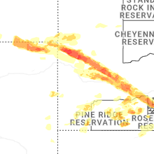
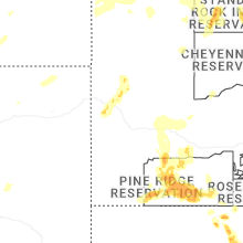


Connect with Interactive Hail Maps