

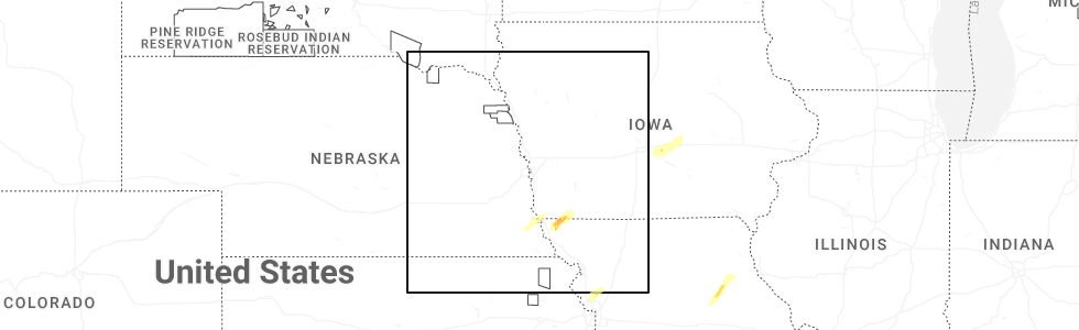
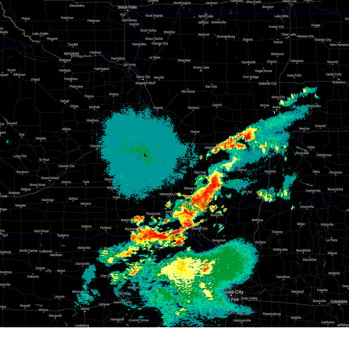
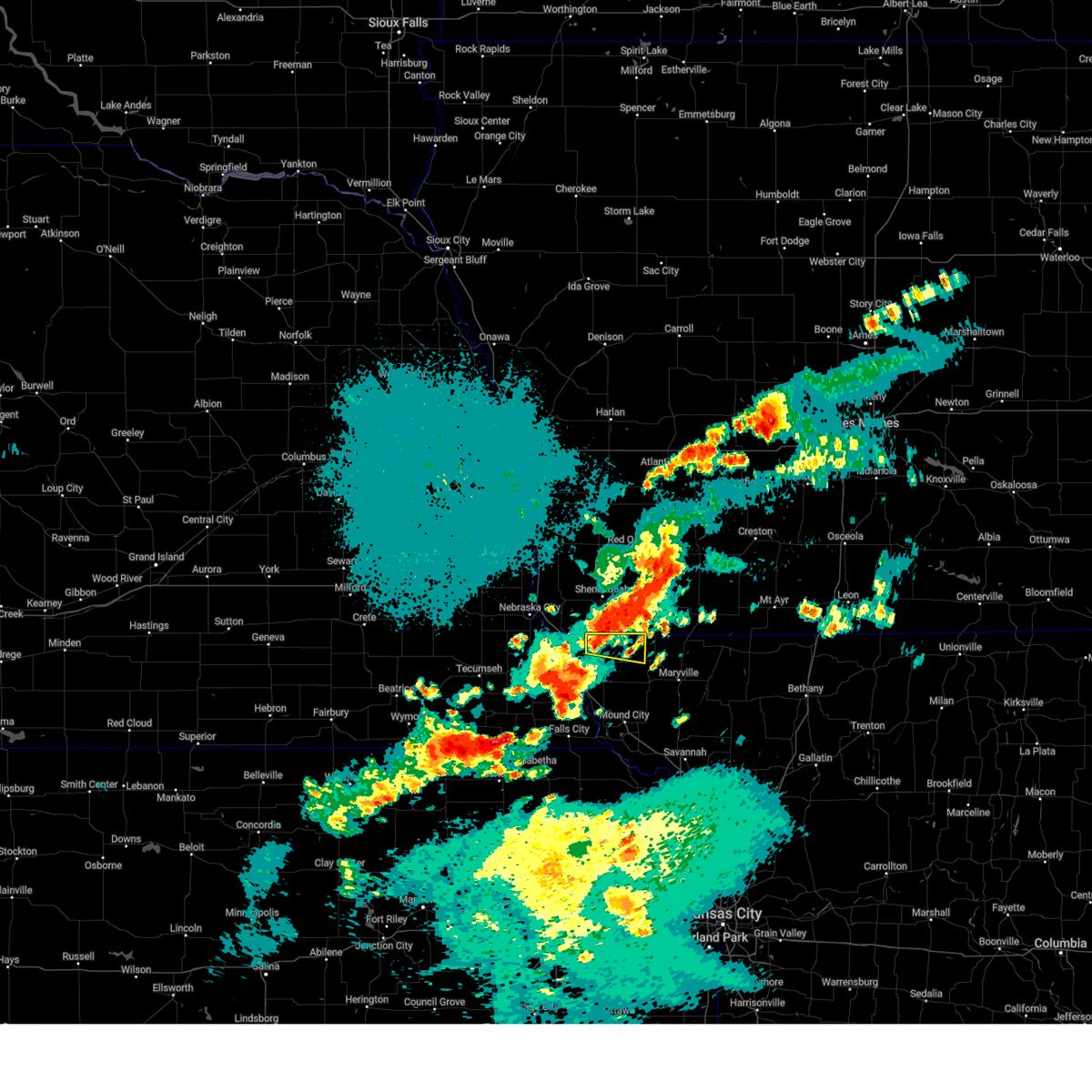
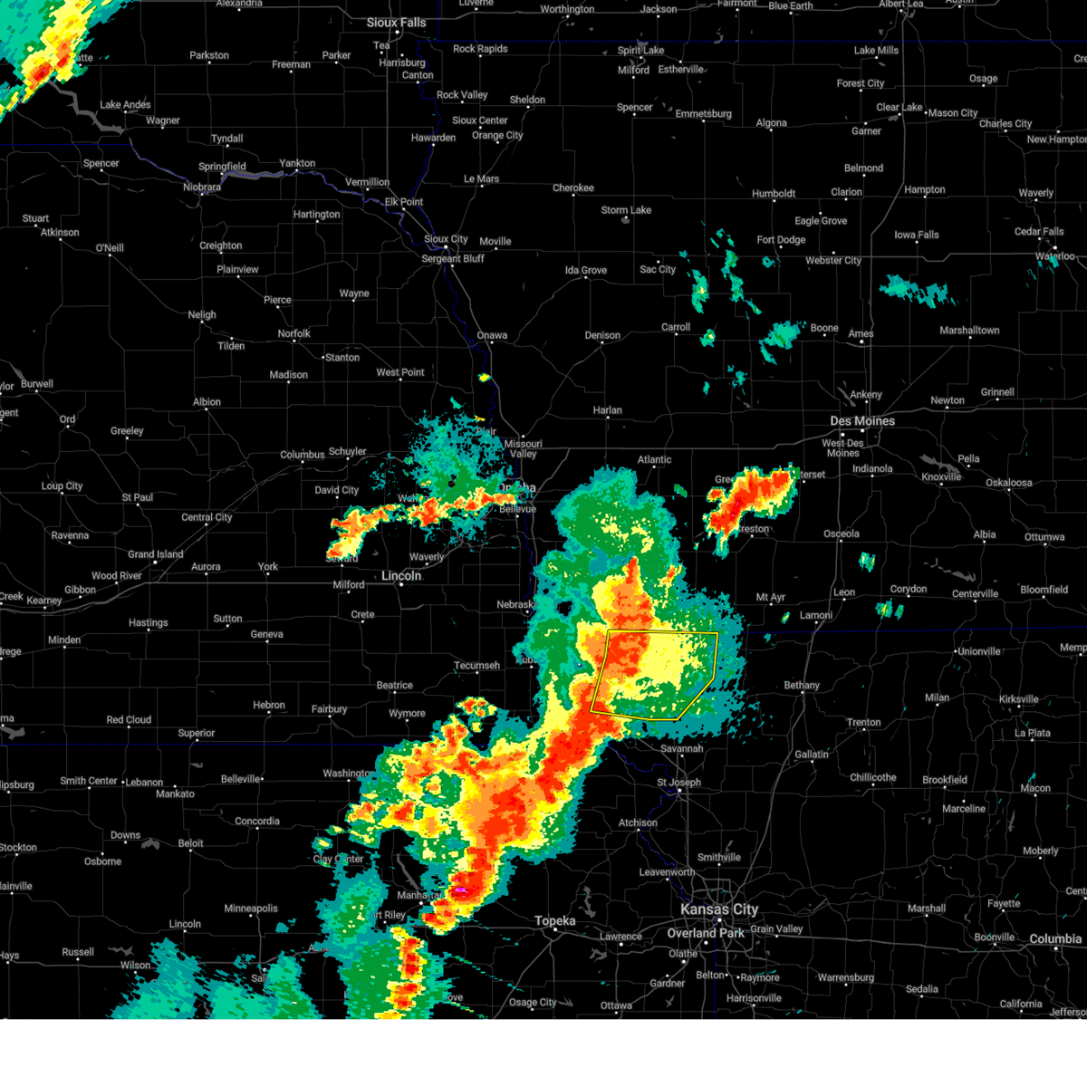
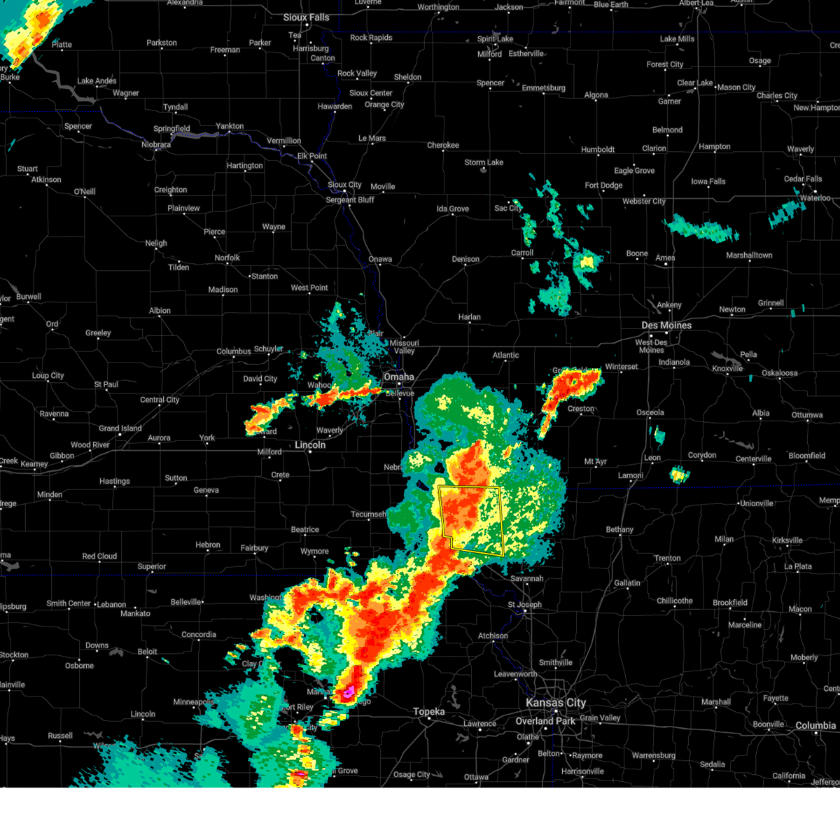
Hail Map for Westboro, MO
The Westboro, MO area has had 12 reports of on-the-ground hail by trained spotters, and has been under severe weather warnings 12 times during the past 12 months. Doppler radar has detected hail at or near Westboro, MO on 73 occasions, including 4 occasions during the past year.
| Name: | Westboro, MO |
| Where Located: | 59.6 miles SSE of Omaha, NE |
| Map: | Google Map for Westboro, MO |
| Population: | 141 |
| Housing Units: | 71 |
| More Info: | Search Google for Westboro, MO |
4
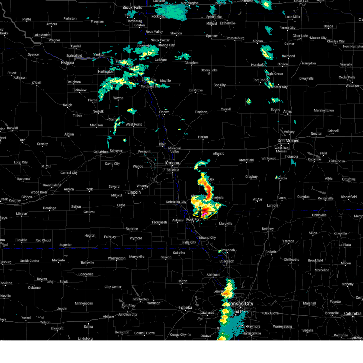
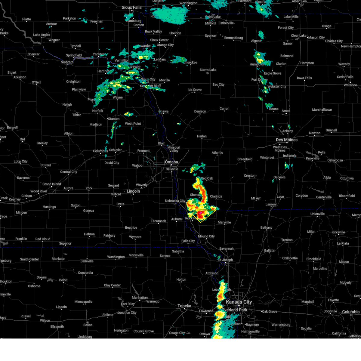
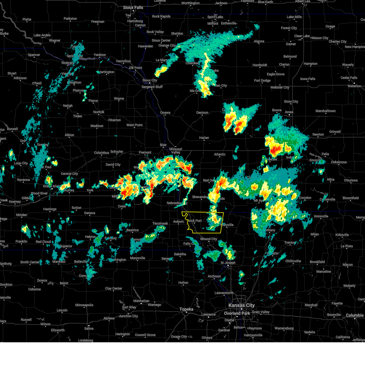
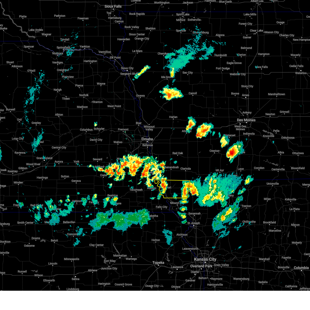
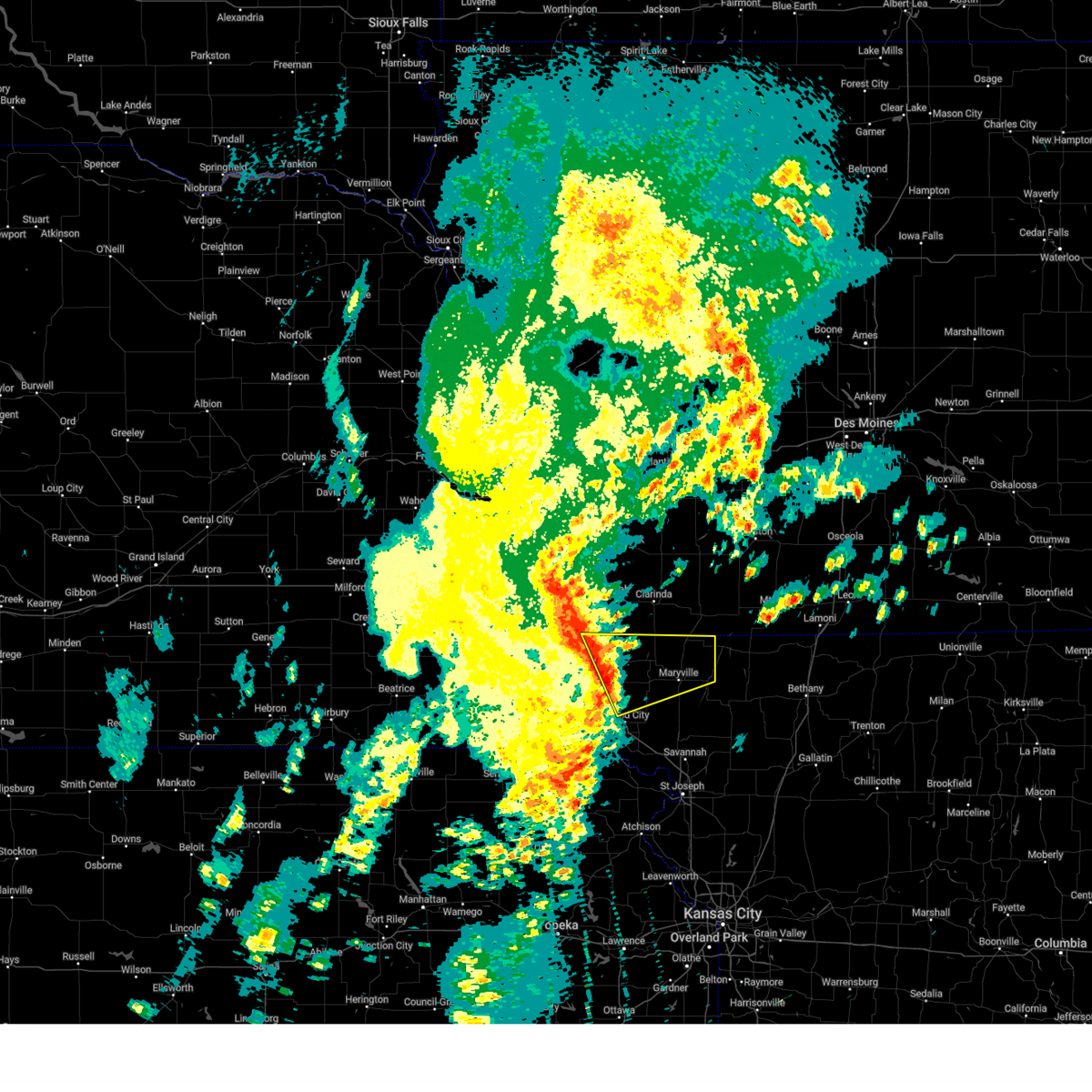
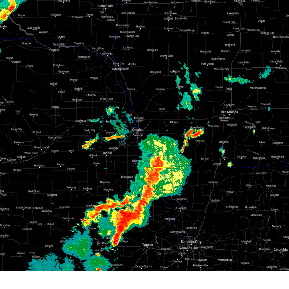
The Top Recent Hail Date for Westboro, MO is Saturday, March 29, 2025 (4th out of 73)
Hail and Wind Damage Spotted near Westboro, MO
| Date / Time | Report Details |
|---|---|
| 3/29/2025 9:31 PM CDT |
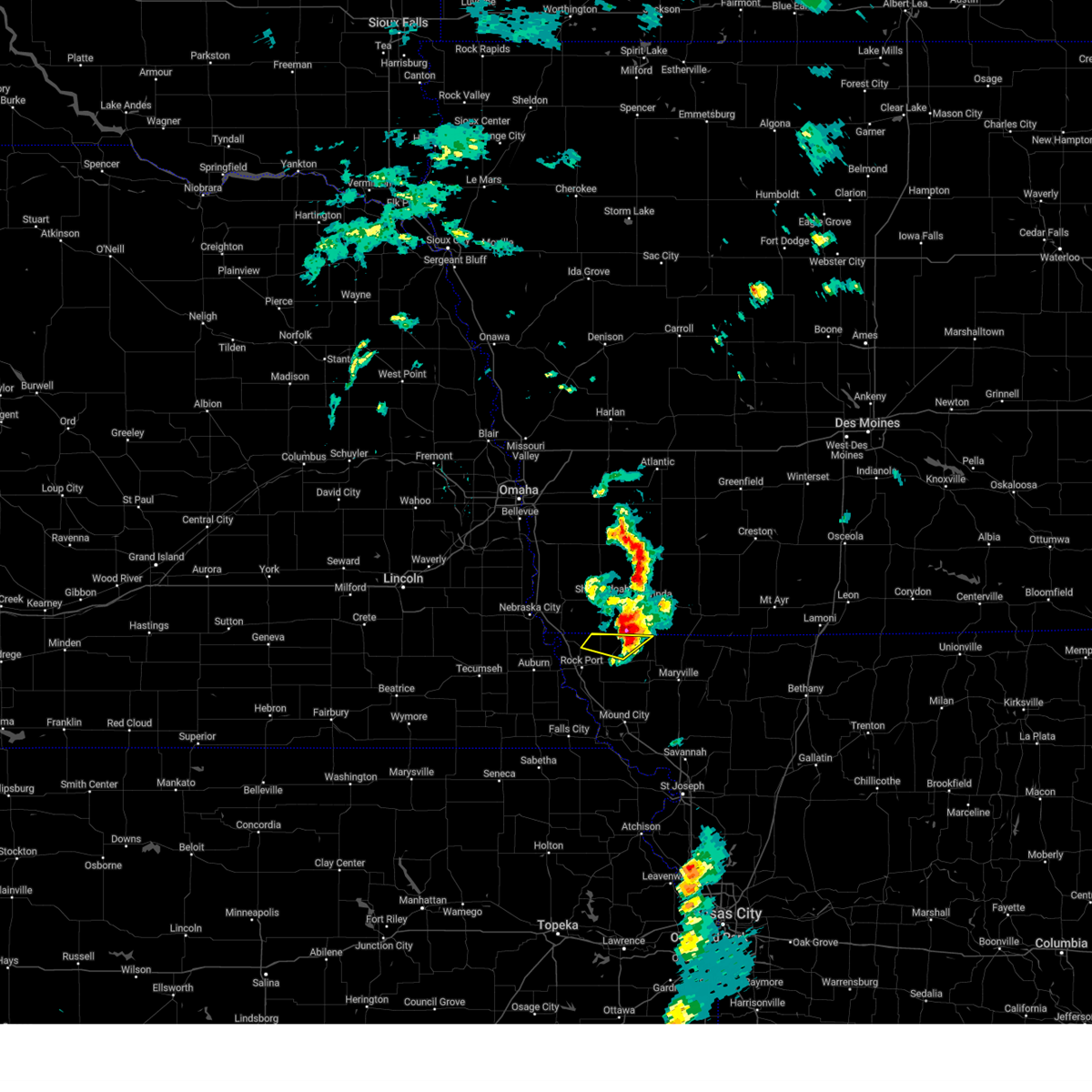 The storm which prompted the warning has moved out of the area. therefore, the warning has been allowed to expire. to report severe weather, contact your nearest law enforcement agency. they will relay your report to the national weather service pleasant hill. The storm which prompted the warning has moved out of the area. therefore, the warning has been allowed to expire. to report severe weather, contact your nearest law enforcement agency. they will relay your report to the national weather service pleasant hill.
|
| 3/29/2025 9:22 PM CDT |
 At 922 pm cdt, a severe thunderstorm was located near blanchard, or 10 miles northeast of tarkio, moving northeast at 35 mph (public. quarter size hail was reported with this storm at 907 pm in tarkio). Hazards include 60 mph wind gusts and quarter size hail. Hail damage to vehicles is expected. expect wind damage to roofs, siding, and trees. Locations impacted include, westboro and elmo. At 922 pm cdt, a severe thunderstorm was located near blanchard, or 10 miles northeast of tarkio, moving northeast at 35 mph (public. quarter size hail was reported with this storm at 907 pm in tarkio). Hazards include 60 mph wind gusts and quarter size hail. Hail damage to vehicles is expected. expect wind damage to roofs, siding, and trees. Locations impacted include, westboro and elmo.
|
| 3/29/2025 9:13 PM CDT |
 At 912 pm cdt, a severe thunderstorm was located near tarkio, moving northeast at 35 mph (public reported quarter sized hail in tarkio). Hazards include 60 mph wind gusts and quarter size hail. Hail damage to vehicles is expected. expect wind damage to roofs, siding, and trees. Locations impacted include, westboro, tarkio, and elmo. At 912 pm cdt, a severe thunderstorm was located near tarkio, moving northeast at 35 mph (public reported quarter sized hail in tarkio). Hazards include 60 mph wind gusts and quarter size hail. Hail damage to vehicles is expected. expect wind damage to roofs, siding, and trees. Locations impacted include, westboro, tarkio, and elmo.
|
| 3/29/2025 9:05 PM CDT |
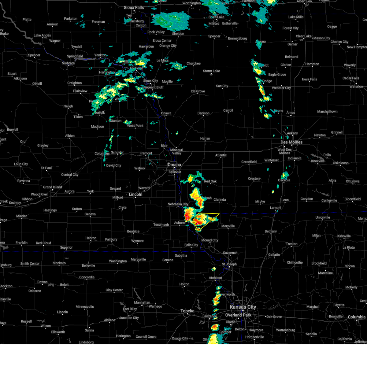 Svreax the national weather service in pleasant hill has issued a * severe thunderstorm warning for, eastern atchison county in northwestern missouri, northwestern nodaway county in northwestern missouri, * until 930 pm cdt. * at 905 pm cdt, a severe thunderstorm was located over tarkio, moving northeast at 35 mph (radar indicated). Hazards include 60 mph wind gusts and quarter size hail. Hail damage to vehicles is expected. Expect wind damage to roofs, siding, and trees. Svreax the national weather service in pleasant hill has issued a * severe thunderstorm warning for, eastern atchison county in northwestern missouri, northwestern nodaway county in northwestern missouri, * until 930 pm cdt. * at 905 pm cdt, a severe thunderstorm was located over tarkio, moving northeast at 35 mph (radar indicated). Hazards include 60 mph wind gusts and quarter size hail. Hail damage to vehicles is expected. Expect wind damage to roofs, siding, and trees.
|
| 3/14/2025 4:51 PM CDT |
 The storm which prompted the warning has moved out of the area. therefore, the warning will be allowed to expire. however, gusty winds are still expected. a severe thunderstorm watch remains in effect until 700 pm cdt for northwestern missouri. The storm which prompted the warning has moved out of the area. therefore, the warning will be allowed to expire. however, gusty winds are still expected. a severe thunderstorm watch remains in effect until 700 pm cdt for northwestern missouri.
|
| 3/14/2025 4:15 PM CDT |
 Svreax the national weather service in pleasant hill has issued a * severe thunderstorm warning for, atchison county in northwestern missouri, northwestern nodaway county in northwestern missouri, * until 500 pm cdt. * at 414 pm cdt, a cluster of severe thunderstorms were located near rock port, or 9 miles west of tarkio, moving north at 65 mph (radar indicated). Hazards include 70 mph wind gusts and penny size hail. Expect considerable tree damage. Damage is likely to mobile homes, roofs, and outbuildings. Svreax the national weather service in pleasant hill has issued a * severe thunderstorm warning for, atchison county in northwestern missouri, northwestern nodaway county in northwestern missouri, * until 500 pm cdt. * at 414 pm cdt, a cluster of severe thunderstorms were located near rock port, or 9 miles west of tarkio, moving north at 65 mph (radar indicated). Hazards include 70 mph wind gusts and penny size hail. Expect considerable tree damage. Damage is likely to mobile homes, roofs, and outbuildings.
|
| 10/30/2024 1:27 PM CDT |
 Svreax the national weather service in pleasant hill has issued a * severe thunderstorm warning for, eastern atchison county in northwestern missouri, north central holt county in northwestern missouri, nodaway county in northwestern missouri, * until 200 pm cdt. * at 127 pm cdt, a severe thunderstorm was located 7 miles west of burlington junction, or 9 miles east of tarkio, moving northeast at 75 mph (radar indicated). Hazards include 70 mph wind gusts and quarter size hail. Hail damage to vehicles is expected. expect considerable tree damage. Wind damage is also likely to mobile homes, roofs, and outbuildings. Svreax the national weather service in pleasant hill has issued a * severe thunderstorm warning for, eastern atchison county in northwestern missouri, north central holt county in northwestern missouri, nodaway county in northwestern missouri, * until 200 pm cdt. * at 127 pm cdt, a severe thunderstorm was located 7 miles west of burlington junction, or 9 miles east of tarkio, moving northeast at 75 mph (radar indicated). Hazards include 70 mph wind gusts and quarter size hail. Hail damage to vehicles is expected. expect considerable tree damage. Wind damage is also likely to mobile homes, roofs, and outbuildings.
|
| 9/21/2024 8:25 PM CDT |
 the severe thunderstorm warning has been cancelled and is no longer in effect the severe thunderstorm warning has been cancelled and is no longer in effect
|
| 9/21/2024 8:10 PM CDT |
 Svreax the national weather service in pleasant hill has issued a * severe thunderstorm warning for, northeastern atchison county in northwestern missouri, northwestern nodaway county in northwestern missouri, * until 900 pm cdt. * at 810 pm cdt, a severe thunderstorm was located near tarkio, moving east at 20 mph (radar indicated). Hazards include 60 mph wind gusts and quarter size hail. Hail damage to vehicles is expected. Expect wind damage to roofs, siding, and trees. Svreax the national weather service in pleasant hill has issued a * severe thunderstorm warning for, northeastern atchison county in northwestern missouri, northwestern nodaway county in northwestern missouri, * until 900 pm cdt. * at 810 pm cdt, a severe thunderstorm was located near tarkio, moving east at 20 mph (radar indicated). Hazards include 60 mph wind gusts and quarter size hail. Hail damage to vehicles is expected. Expect wind damage to roofs, siding, and trees.
|
| 8/14/2024 9:09 PM CDT |
 Svreax the national weather service in pleasant hill has issued a * severe thunderstorm warning for, northwestern worth county in northwestern missouri, eastern atchison county in northwestern missouri, northern holt county in northwestern missouri, nodaway county in northwestern missouri, * until 945 pm cdt. * at 909 pm cdt, severe thunderstorms were located along a line extending from near shambaugh to 3 miles south of burlington junction to 3 miles northwest of mound city, moving east at 40 mph (radar indicated). Hazards include 60 mph wind gusts and penny size hail. expect damage to roofs, siding, and trees Svreax the national weather service in pleasant hill has issued a * severe thunderstorm warning for, northwestern worth county in northwestern missouri, eastern atchison county in northwestern missouri, northern holt county in northwestern missouri, nodaway county in northwestern missouri, * until 945 pm cdt. * at 909 pm cdt, severe thunderstorms were located along a line extending from near shambaugh to 3 miles south of burlington junction to 3 miles northwest of mound city, moving east at 40 mph (radar indicated). Hazards include 60 mph wind gusts and penny size hail. expect damage to roofs, siding, and trees
|
| 8/14/2024 9:02 PM CDT |
 At 902 pm cdt, a severe thunderstorm was located near burlington junction, moving east at 45 mph (radar indicated). Hazards include 60 mph wind gusts and penny size hail. Expect damage to roofs, siding, and trees. Locations impacted include, tarkio, rock port, fairfax, burlington junction, maitland, skidmore, craig, and blanchard. At 902 pm cdt, a severe thunderstorm was located near burlington junction, moving east at 45 mph (radar indicated). Hazards include 60 mph wind gusts and penny size hail. Expect damage to roofs, siding, and trees. Locations impacted include, tarkio, rock port, fairfax, burlington junction, maitland, skidmore, craig, and blanchard.
|
| 8/14/2024 8:44 PM CDT |
 Svreax the national weather service in pleasant hill has issued a * severe thunderstorm warning for, atchison county in northwestern missouri, northern holt county in northwestern missouri, western nodaway county in northwestern missouri, * until 915 pm cdt. * at 843 pm cdt, a severe thunderstorm was located over tarkio, moving east at 40 mph (radar indicated). Hazards include 60 mph wind gusts and penny size hail. expect damage to roofs, siding, and trees Svreax the national weather service in pleasant hill has issued a * severe thunderstorm warning for, atchison county in northwestern missouri, northern holt county in northwestern missouri, western nodaway county in northwestern missouri, * until 915 pm cdt. * at 843 pm cdt, a severe thunderstorm was located over tarkio, moving east at 40 mph (radar indicated). Hazards include 60 mph wind gusts and penny size hail. expect damage to roofs, siding, and trees
|
| 6/15/2024 8:12 PM CDT |
 At 812 pm cdt, severe thunderstorms were located along a line extending from near farragut to 7 miles northwest of skidmore to highland, moving northeast at 45 mph (trained weather spotters). Hazards include 60 mph wind gusts and penny size hail. Expect damage to roofs, siding, and trees. locations impacted include, tarkio, mound city, rock port, fairfax, burlington junction, maitland, skidmore, craig, graham, clearmont, elmo, big lake, westboro, quitman, fortescue, bigelow, and corning. This includes interstate 29 between mile markers 80 and 112. At 812 pm cdt, severe thunderstorms were located along a line extending from near farragut to 7 miles northwest of skidmore to highland, moving northeast at 45 mph (trained weather spotters). Hazards include 60 mph wind gusts and penny size hail. Expect damage to roofs, siding, and trees. locations impacted include, tarkio, mound city, rock port, fairfax, burlington junction, maitland, skidmore, craig, graham, clearmont, elmo, big lake, westboro, quitman, fortescue, bigelow, and corning. This includes interstate 29 between mile markers 80 and 112.
|
| 6/15/2024 7:49 PM CDT |
 At 749 pm cdt, severe thunderstorms were located along a line extending from near nebraska city to 7 miles west of craig to near powhattan, moving northeast at 40 mph (trained weather spotters). Hazards include 70 mph wind gusts and penny size hail. Expect considerable tree damage. damage is likely to mobile homes, roofs, and outbuildings. locations impacted include, tarkio, mound city, rock port, fairfax, burlington junction, maitland, skidmore, craig, graham, clearmont, elmo, big lake, westboro, watson, quitman, fortescue, bigelow, corning, phelps city, and brownville state recreation area. This includes interstate 29 between mile markers 80 and 123. At 749 pm cdt, severe thunderstorms were located along a line extending from near nebraska city to 7 miles west of craig to near powhattan, moving northeast at 40 mph (trained weather spotters). Hazards include 70 mph wind gusts and penny size hail. Expect considerable tree damage. damage is likely to mobile homes, roofs, and outbuildings. locations impacted include, tarkio, mound city, rock port, fairfax, burlington junction, maitland, skidmore, craig, graham, clearmont, elmo, big lake, westboro, watson, quitman, fortescue, bigelow, corning, phelps city, and brownville state recreation area. This includes interstate 29 between mile markers 80 and 123.
|
| 6/15/2024 7:35 PM CDT |
 Svreax the national weather service in pleasant hill has issued a * severe thunderstorm warning for, atchison county in northwestern missouri, northern holt county in northwestern missouri, western nodaway county in northwestern missouri, * until 830 pm cdt. * at 734 pm cdt, severe thunderstorms were located along a line extending from near lorton to near verdon to near kickapoo reservation, moving northeast at 45 mph (radar indicated). Hazards include 60 mph wind gusts and quarter size hail. Hail damage to vehicles is expected. Expect wind damage to roofs, siding, and trees. Svreax the national weather service in pleasant hill has issued a * severe thunderstorm warning for, atchison county in northwestern missouri, northern holt county in northwestern missouri, western nodaway county in northwestern missouri, * until 830 pm cdt. * at 734 pm cdt, severe thunderstorms were located along a line extending from near lorton to near verdon to near kickapoo reservation, moving northeast at 45 mph (radar indicated). Hazards include 60 mph wind gusts and quarter size hail. Hail damage to vehicles is expected. Expect wind damage to roofs, siding, and trees.
|
| 6/4/2024 5:37 PM CDT |
 Svreax the national weather service in pleasant hill has issued a * severe thunderstorm warning for, eastern atchison county in northwestern missouri, northeastern holt county in northwestern missouri, western nodaway county in northwestern missouri, * until 615 pm cdt. * at 537 pm cdt, severe thunderstorms were located along a line extending from near blanchard to 7 miles southeast of fairfax to near craig, moving east at 55 mph (radar indicated). Hazards include 60 mph wind gusts and nickel size hail. expect damage to roofs, siding, and trees Svreax the national weather service in pleasant hill has issued a * severe thunderstorm warning for, eastern atchison county in northwestern missouri, northeastern holt county in northwestern missouri, western nodaway county in northwestern missouri, * until 615 pm cdt. * at 537 pm cdt, severe thunderstorms were located along a line extending from near blanchard to 7 miles southeast of fairfax to near craig, moving east at 55 mph (radar indicated). Hazards include 60 mph wind gusts and nickel size hail. expect damage to roofs, siding, and trees
|
| 5/24/2024 4:00 AM CDT |
 At 400 am cdt, severe thunderstorms were located along a line extending from near blanchard to 6 miles west of skidmore to near white cloud, moving east at 45 mph (radar indicated). Hazards include 60 mph wind gusts. Expect damage to roofs, siding, and trees. locations impacted include, maryville, tarkio, mound city, rock port, fairfax, burlington junction, hopkins, maitland, skidmore, craig, graham, clearmont, elmo, pickering, big lake, westboro, arkoe, quitman, fortescue, and bigelow. This includes interstate 29 between mile markers 76 and 113. At 400 am cdt, severe thunderstorms were located along a line extending from near blanchard to 6 miles west of skidmore to near white cloud, moving east at 45 mph (radar indicated). Hazards include 60 mph wind gusts. Expect damage to roofs, siding, and trees. locations impacted include, maryville, tarkio, mound city, rock port, fairfax, burlington junction, hopkins, maitland, skidmore, craig, graham, clearmont, elmo, pickering, big lake, westboro, arkoe, quitman, fortescue, and bigelow. This includes interstate 29 between mile markers 76 and 113.
|
| 5/24/2024 3:16 AM CDT |
 Svreax the national weather service in pleasant hill has issued a * severe thunderstorm warning for, atchison county in northwestern missouri, holt county in northwestern missouri, nodaway county in northwestern missouri, * until 415 am cdt. * at 315 am cdt, severe thunderstorms were located along a line extending from near nebraska city to near auburn to near du bois, moving east at 50 mph (radar indicated). Hazards include 60 mph wind gusts. expect damage to roofs, siding, and trees Svreax the national weather service in pleasant hill has issued a * severe thunderstorm warning for, atchison county in northwestern missouri, holt county in northwestern missouri, nodaway county in northwestern missouri, * until 415 am cdt. * at 315 am cdt, severe thunderstorms were located along a line extending from near nebraska city to near auburn to near du bois, moving east at 50 mph (radar indicated). Hazards include 60 mph wind gusts. expect damage to roofs, siding, and trees
|
| 5/19/2024 8:07 PM CDT |
 At 807 pm cdt, a severe thunderstorm was located 7 miles south of blanchard, or 9 miles east of tarkio, moving northeast at 35 mph (radar indicated). Hazards include 60 mph wind gusts and quarter size hail. Hail damage to vehicles is expected. expect wind damage to roofs, siding, and trees. Locations impacted include, burlington junction, hopkins, clearmont, elmo, and westboro. At 807 pm cdt, a severe thunderstorm was located 7 miles south of blanchard, or 9 miles east of tarkio, moving northeast at 35 mph (radar indicated). Hazards include 60 mph wind gusts and quarter size hail. Hail damage to vehicles is expected. expect wind damage to roofs, siding, and trees. Locations impacted include, burlington junction, hopkins, clearmont, elmo, and westboro.
|
| 5/19/2024 7:56 PM CDT |
 Svreax the national weather service in pleasant hill has issued a * severe thunderstorm warning for, northeastern atchison county in northwestern missouri, northwestern nodaway county in northwestern missouri, * until 845 pm cdt. * at 756 pm cdt, a severe thunderstorm was located near tarkio, moving northeast at 35 mph (radar indicated). Hazards include 60 mph wind gusts and quarter size hail. Hail damage to vehicles is expected. Expect wind damage to roofs, siding, and trees. Svreax the national weather service in pleasant hill has issued a * severe thunderstorm warning for, northeastern atchison county in northwestern missouri, northwestern nodaway county in northwestern missouri, * until 845 pm cdt. * at 756 pm cdt, a severe thunderstorm was located near tarkio, moving northeast at 35 mph (radar indicated). Hazards include 60 mph wind gusts and quarter size hail. Hail damage to vehicles is expected. Expect wind damage to roofs, siding, and trees.
|
| 5/19/2024 7:20 PM CDT |
 Svreax the national weather service in pleasant hill has issued a * severe thunderstorm warning for, atchison county in northwestern missouri, * until 800 pm cdt. * at 719 pm cdt, a severe thunderstorm was located near nemaha, or 10 miles southeast of auburn, moving northeast at 30 mph (radar indicated). Hazards include 60 mph wind gusts and half dollar size hail. Hail damage to vehicles is expected. Expect wind damage to roofs, siding, and trees. Svreax the national weather service in pleasant hill has issued a * severe thunderstorm warning for, atchison county in northwestern missouri, * until 800 pm cdt. * at 719 pm cdt, a severe thunderstorm was located near nemaha, or 10 miles southeast of auburn, moving northeast at 30 mph (radar indicated). Hazards include 60 mph wind gusts and half dollar size hail. Hail damage to vehicles is expected. Expect wind damage to roofs, siding, and trees.
|
| 5/6/2024 9:51 PM CDT |
 The storms which prompted the warning have weakened below severe limits, and no longer pose an immediate threat to life or property. therefore, the warning will be allowed to expire. however, gusty winds and heavy rain are still possible with these thunderstorms. a tornado watch remains in effect until 1100 pm cdt for northeastern kansas, and northwestern missouri. a tornado watch also remains in effect until 400 am cdt for northwestern missouri. to report severe weather, contact your nearest law enforcement agency. they will relay your report to the national weather service pleasant hill. The storms which prompted the warning have weakened below severe limits, and no longer pose an immediate threat to life or property. therefore, the warning will be allowed to expire. however, gusty winds and heavy rain are still possible with these thunderstorms. a tornado watch remains in effect until 1100 pm cdt for northeastern kansas, and northwestern missouri. a tornado watch also remains in effect until 400 am cdt for northwestern missouri. to report severe weather, contact your nearest law enforcement agency. they will relay your report to the national weather service pleasant hill.
|
| 5/6/2024 9:33 PM CDT |
 At 933 pm cdt, severe thunderstorms were located along a line extending from near red oak to near tarkio to near falls city, moving northeast at 50 mph (radar indicated). Hazards include 60 mph wind gusts and penny size hail. Expect damage to roofs, siding, and trees. locations impacted include, tarkio, mound city, rock port, fairfax, craig, blanchard, big lake, westboro, fortescue, bigelow, corning, and indian cave state park. This includes interstate 29 between mile markers 80 and 113. At 933 pm cdt, severe thunderstorms were located along a line extending from near red oak to near tarkio to near falls city, moving northeast at 50 mph (radar indicated). Hazards include 60 mph wind gusts and penny size hail. Expect damage to roofs, siding, and trees. locations impacted include, tarkio, mound city, rock port, fairfax, craig, blanchard, big lake, westboro, fortescue, bigelow, corning, and indian cave state park. This includes interstate 29 between mile markers 80 and 113.
|
| 5/6/2024 9:14 PM CDT |
 At 913 pm cdt, severe thunderstorms were located along a line extending from 6 miles northwest of essex to 6 miles southwest of fairfax to near morrill, moving northeast at 55 mph (trained weather spotters. a 64 mph wind gust was reported southwest of nemaha, nebraska, as these storms passed). Hazards include 70 mph wind gusts and quarter size hail. Hail damage to vehicles is expected. expect considerable tree damage. wind damage is also likely to mobile homes, roofs, and outbuildings. locations impacted include, tarkio, mound city, rock port, fairfax, craig, blanchard, big lake, westboro, watson, fortescue, bigelow, corning, phelps city, and indian cave state park. This includes interstate 29 between mile markers 80 and 123. At 913 pm cdt, severe thunderstorms were located along a line extending from 6 miles northwest of essex to 6 miles southwest of fairfax to near morrill, moving northeast at 55 mph (trained weather spotters. a 64 mph wind gust was reported southwest of nemaha, nebraska, as these storms passed). Hazards include 70 mph wind gusts and quarter size hail. Hail damage to vehicles is expected. expect considerable tree damage. wind damage is also likely to mobile homes, roofs, and outbuildings. locations impacted include, tarkio, mound city, rock port, fairfax, craig, blanchard, big lake, westboro, watson, fortescue, bigelow, corning, phelps city, and indian cave state park. This includes interstate 29 between mile markers 80 and 123.
|
| 5/6/2024 8:44 PM CDT |
 Svreax the national weather service in pleasant hill has issued a * severe thunderstorm warning for, atchison county in northwestern missouri, northwestern holt county in northwestern missouri, * until 1000 pm cdt. * at 844 pm cdt, severe thunderstorms were located along a line extending from near nebraska city to near dawson to near corning, moving northeast at 50 mph (radar indicated). Hazards include 60 mph wind gusts and quarter size hail. Hail damage to vehicles is expected. Expect wind damage to roofs, siding, and trees. Svreax the national weather service in pleasant hill has issued a * severe thunderstorm warning for, atchison county in northwestern missouri, northwestern holt county in northwestern missouri, * until 1000 pm cdt. * at 844 pm cdt, severe thunderstorms were located along a line extending from near nebraska city to near dawson to near corning, moving northeast at 50 mph (radar indicated). Hazards include 60 mph wind gusts and quarter size hail. Hail damage to vehicles is expected. Expect wind damage to roofs, siding, and trees.
|
| 4/30/2024 5:36 PM CDT |
 At 536 pm cdt, a severe thunderstorm was located over blanchard, or 10 miles northeast of tarkio, moving east at 40 mph (radar indicated). Hazards include 60 mph wind gusts and quarter size hail. Hail damage to vehicles is expected. expect wind damage to roofs, siding, and trees. Locations impacted include, burlington junction, braddyville, blanchard, clearmont, elmo, and westboro. At 536 pm cdt, a severe thunderstorm was located over blanchard, or 10 miles northeast of tarkio, moving east at 40 mph (radar indicated). Hazards include 60 mph wind gusts and quarter size hail. Hail damage to vehicles is expected. expect wind damage to roofs, siding, and trees. Locations impacted include, burlington junction, braddyville, blanchard, clearmont, elmo, and westboro.
|
| 4/30/2024 5:24 PM CDT |
 Svreax the national weather service in pleasant hill has issued a * severe thunderstorm warning for, northeastern atchison county in northwestern missouri, northwestern nodaway county in northwestern missouri, * until 615 pm cdt. * at 523 pm cdt, a severe thunderstorm was located 8 miles north of tarkio, moving east at 40 mph (radar indicated). Hazards include golf ball size hail and 60 mph wind gusts. People and animals outdoors will be injured. expect hail damage to roofs, siding, windows, and vehicles. Expect wind damage to roofs, siding, and trees. Svreax the national weather service in pleasant hill has issued a * severe thunderstorm warning for, northeastern atchison county in northwestern missouri, northwestern nodaway county in northwestern missouri, * until 615 pm cdt. * at 523 pm cdt, a severe thunderstorm was located 8 miles north of tarkio, moving east at 40 mph (radar indicated). Hazards include golf ball size hail and 60 mph wind gusts. People and animals outdoors will be injured. expect hail damage to roofs, siding, windows, and vehicles. Expect wind damage to roofs, siding, and trees.
|
| 4/26/2024 5:26 PM CDT |
 At 526 pm cdt, a severe thunderstorm was located near fairfax, or 8 miles southwest of tarkio, moving northeast at 55 mph (radar indicated). Hazards include 60 mph wind gusts and quarter size hail. Hail damage to vehicles is expected. expect wind damage to roofs, siding, and trees. locations impacted include, tarkio, rock port, fairfax, blanchard, westboro, and indian cave state park. This includes interstate 29 between mile markers 99 and 111. At 526 pm cdt, a severe thunderstorm was located near fairfax, or 8 miles southwest of tarkio, moving northeast at 55 mph (radar indicated). Hazards include 60 mph wind gusts and quarter size hail. Hail damage to vehicles is expected. expect wind damage to roofs, siding, and trees. locations impacted include, tarkio, rock port, fairfax, blanchard, westboro, and indian cave state park. This includes interstate 29 between mile markers 99 and 111.
|
| 4/26/2024 5:24 PM CDT |
 Svreax the national weather service in pleasant hill has issued a * severe thunderstorm warning for, eastern atchison county in northwestern missouri, northwestern holt county in northwestern missouri, * until 615 pm cdt. * at 523 pm cdt, a severe thunderstorm was located near falls city, moving northeast at 55 mph (radar indicated). Hazards include ping pong ball size hail and 60 mph wind gusts. People and animals outdoors will be injured. expect hail damage to roofs, siding, windows, and vehicles. Expect wind damage to roofs, siding, and trees. Svreax the national weather service in pleasant hill has issued a * severe thunderstorm warning for, eastern atchison county in northwestern missouri, northwestern holt county in northwestern missouri, * until 615 pm cdt. * at 523 pm cdt, a severe thunderstorm was located near falls city, moving northeast at 55 mph (radar indicated). Hazards include ping pong ball size hail and 60 mph wind gusts. People and animals outdoors will be injured. expect hail damage to roofs, siding, windows, and vehicles. Expect wind damage to roofs, siding, and trees.
|
| 4/26/2024 4:48 PM CDT |
 Svreax the national weather service in pleasant hill has issued a * severe thunderstorm warning for, atchison county in northwestern missouri, * until 545 pm cdt. * at 448 pm cdt, a severe thunderstorm was located near shubert, or 11 miles northwest of falls city, moving northeast at 55 mph (radar indicated). Hazards include 60 mph wind gusts and half dollar size hail. Hail damage to vehicles is expected. Expect wind damage to roofs, siding, and trees. Svreax the national weather service in pleasant hill has issued a * severe thunderstorm warning for, atchison county in northwestern missouri, * until 545 pm cdt. * at 448 pm cdt, a severe thunderstorm was located near shubert, or 11 miles northwest of falls city, moving northeast at 55 mph (radar indicated). Hazards include 60 mph wind gusts and half dollar size hail. Hail damage to vehicles is expected. Expect wind damage to roofs, siding, and trees.
|
| 4/16/2024 8:13 AM CDT |
 Svreax the national weather service in pleasant hill has issued a * severe thunderstorm warning for, doniphan county in northeastern kansas, atchison county in northeastern kansas, eastern atchison county in northwestern missouri, holt county in northwestern missouri, nodaway county in northwestern missouri, northwestern andrew county in northwestern missouri, * until 900 am cdt. * at 813 am cdt, severe thunderstorms were located along a line extending from rulo to highland, moving northeast at 55 mph (radar indicated). Hazards include 60 mph wind gusts. expect damage to roofs, siding, and trees Svreax the national weather service in pleasant hill has issued a * severe thunderstorm warning for, doniphan county in northeastern kansas, atchison county in northeastern kansas, eastern atchison county in northwestern missouri, holt county in northwestern missouri, nodaway county in northwestern missouri, northwestern andrew county in northwestern missouri, * until 900 am cdt. * at 813 am cdt, severe thunderstorms were located along a line extending from rulo to highland, moving northeast at 55 mph (radar indicated). Hazards include 60 mph wind gusts. expect damage to roofs, siding, and trees
|
| 7/29/2023 9:48 AM CDT |
 At 948 am cdt, severe thunderstorms were located along a line extending from near tarkio to near craig to powhattan, moving east at 50 mph (radar indicated). Hazards include 60 mph wind gusts and nickel size hail. Expect damage to roofs, siding, and trees. locations impacted include, tarkio, mound city, rock port, fairfax, craig, white cloud, big lake, westboro, watson, fortescue, bigelow, corning, phelps city and iowa reservation of kansas and nebraska. this includes interstate 29 between mile markers 78 and 123. hail threat, radar indicated max hail size, 0. 88 in wind threat, observed max wind gust, 60 mph. At 948 am cdt, severe thunderstorms were located along a line extending from near tarkio to near craig to powhattan, moving east at 50 mph (radar indicated). Hazards include 60 mph wind gusts and nickel size hail. Expect damage to roofs, siding, and trees. locations impacted include, tarkio, mound city, rock port, fairfax, craig, white cloud, big lake, westboro, watson, fortescue, bigelow, corning, phelps city and iowa reservation of kansas and nebraska. this includes interstate 29 between mile markers 78 and 123. hail threat, radar indicated max hail size, 0. 88 in wind threat, observed max wind gust, 60 mph.
|
| 7/29/2023 9:30 AM CDT |
 At 929 am cdt, severe thunderstorms were located along a line extending from near peru to 6 miles east of shubert to woodlawn, moving east at 50 mph (radar indicated). Hazards include 60 mph wind gusts and nickel size hail. Expect damage to roofs, siding, and trees. locations impacted include, tarkio, mound city, rock port, fairfax, craig, white cloud, big lake, westboro, watson, fortescue, bigelow, corning, phelps city and iowa reservation of kansas and nebraska. this includes interstate 29 between mile markers 78 and 123. hail threat, radar indicated max hail size, 0. 88 in wind threat, observed max wind gust, 60 mph. At 929 am cdt, severe thunderstorms were located along a line extending from near peru to 6 miles east of shubert to woodlawn, moving east at 50 mph (radar indicated). Hazards include 60 mph wind gusts and nickel size hail. Expect damage to roofs, siding, and trees. locations impacted include, tarkio, mound city, rock port, fairfax, craig, white cloud, big lake, westboro, watson, fortescue, bigelow, corning, phelps city and iowa reservation of kansas and nebraska. this includes interstate 29 between mile markers 78 and 123. hail threat, radar indicated max hail size, 0. 88 in wind threat, observed max wind gust, 60 mph.
|
| 7/29/2023 9:15 AM CDT |
 At 914 am cdt, severe thunderstorms were located along a line extending from near julian to near stella to seneca, moving east at 50 mph (trained spotters have reported 60 to 70 mph wind). Hazards include 70 mph wind gusts and nickel size hail. Expect considerable tree damage. Damage is likely to mobile homes, roofs, and outbuildings. At 914 am cdt, severe thunderstorms were located along a line extending from near julian to near stella to seneca, moving east at 50 mph (trained spotters have reported 60 to 70 mph wind). Hazards include 70 mph wind gusts and nickel size hail. Expect considerable tree damage. Damage is likely to mobile homes, roofs, and outbuildings.
|
| 7/24/2023 6:12 AM CDT |
 The severe thunderstorm warning for northwestern doniphan, atchison, holt, western nodaway and northwestern andrew counties will expire at 615 am cdt, the storms which prompted the warning have weakened below severe limits, and no longer pose an immediate threat to life or property. therefore, the warning will be allowed to expire. however small hail and gusty winds are still possible with these thunderstorms. a severe thunderstorm watch remains in effect until 900 am cdt for northwestern missouri. a severe thunderstorm watch also remains in effect until noon cdt for northeastern kansas, and northwestern missouri. The severe thunderstorm warning for northwestern doniphan, atchison, holt, western nodaway and northwestern andrew counties will expire at 615 am cdt, the storms which prompted the warning have weakened below severe limits, and no longer pose an immediate threat to life or property. therefore, the warning will be allowed to expire. however small hail and gusty winds are still possible with these thunderstorms. a severe thunderstorm watch remains in effect until 900 am cdt for northwestern missouri. a severe thunderstorm watch also remains in effect until noon cdt for northeastern kansas, and northwestern missouri.
|
| 7/24/2023 6:07 AM CDT |
 At 604 am cdt, severe thunderstorms were located along a line extending from 6 miles south of blanchard to near white cloud, moving southeast at 35 mph (radar indicated). Hazards include 60 mph wind gusts and nickel size hail. Expect damage to roofs, siding, and trees. locations impacted include, tarkio, mound city, rock port, oregon, fairfax, burlington junction, maitland, skidmore, forest city, craig, white cloud, graham, clearmont, elmo, big lake, westboro, watson, quitman, fortescue and bigelow. this includes interstate 29 between mile markers 68 and 122. hail threat, radar indicated max hail size, 0. 88 in wind threat, radar indicated max wind gust, 60 mph. At 604 am cdt, severe thunderstorms were located along a line extending from 6 miles south of blanchard to near white cloud, moving southeast at 35 mph (radar indicated). Hazards include 60 mph wind gusts and nickel size hail. Expect damage to roofs, siding, and trees. locations impacted include, tarkio, mound city, rock port, oregon, fairfax, burlington junction, maitland, skidmore, forest city, craig, white cloud, graham, clearmont, elmo, big lake, westboro, watson, quitman, fortescue and bigelow. this includes interstate 29 between mile markers 68 and 122. hail threat, radar indicated max hail size, 0. 88 in wind threat, radar indicated max wind gust, 60 mph.
|
| 7/24/2023 5:58 AM CDT |
 At 558 am cdt, severe thunderstorms were located along a line extending from near blanchard to near rulo, moving southeast at 35 mph (radar indicated). Hazards include 60 mph wind gusts and nickel size hail. Expect damage to roofs, siding, and trees. locations impacted include, tarkio, mound city, rock port, oregon, fairfax, burlington junction, maitland, skidmore, forest city, craig, white cloud, graham, clearmont, elmo, big lake, westboro, watson, quitman, fortescue and bigelow. this includes interstate 29 between mile markers 68 and 122. hail threat, radar indicated max hail size, 0. 88 in wind threat, radar indicated max wind gust, 60 mph. At 558 am cdt, severe thunderstorms were located along a line extending from near blanchard to near rulo, moving southeast at 35 mph (radar indicated). Hazards include 60 mph wind gusts and nickel size hail. Expect damage to roofs, siding, and trees. locations impacted include, tarkio, mound city, rock port, oregon, fairfax, burlington junction, maitland, skidmore, forest city, craig, white cloud, graham, clearmont, elmo, big lake, westboro, watson, quitman, fortescue and bigelow. this includes interstate 29 between mile markers 68 and 122. hail threat, radar indicated max hail size, 0. 88 in wind threat, radar indicated max wind gust, 60 mph.
|
| 7/24/2023 5:50 AM CDT |
 At 549 am cdt, severe thunderstorms were located along a line extending from 8 miles west of blanchard to near rulo, moving southeast at 35 mph (radar indicated). Hazards include 60 mph wind gusts and half dollar size hail. Hail damage to vehicles is expected. expect wind damage to roofs, siding, and trees. locations impacted include, tarkio, mound city, rock port, oregon, fairfax, burlington junction, maitland, skidmore, forest city, craig, white cloud, graham, clearmont, elmo, big lake, westboro, watson, quitman, fortescue and bigelow. this includes interstate 29 between mile markers 68 and 123. hail threat, radar indicated max hail size, 1. 25 in wind threat, radar indicated max wind gust, 60 mph. At 549 am cdt, severe thunderstorms were located along a line extending from 8 miles west of blanchard to near rulo, moving southeast at 35 mph (radar indicated). Hazards include 60 mph wind gusts and half dollar size hail. Hail damage to vehicles is expected. expect wind damage to roofs, siding, and trees. locations impacted include, tarkio, mound city, rock port, oregon, fairfax, burlington junction, maitland, skidmore, forest city, craig, white cloud, graham, clearmont, elmo, big lake, westboro, watson, quitman, fortescue and bigelow. this includes interstate 29 between mile markers 68 and 123. hail threat, radar indicated max hail size, 1. 25 in wind threat, radar indicated max wind gust, 60 mph.
|
| 7/24/2023 5:38 AM CDT |
 At 538 am cdt, severe thunderstorms were located along a line extending from 6 miles north of tarkio to near rulo, moving southeast at 35 mph (radar indicated). Hazards include 60 mph wind gusts and half dollar size hail. Hail damage to vehicles is expected. Expect wind damage to roofs, siding, and trees. At 538 am cdt, severe thunderstorms were located along a line extending from 6 miles north of tarkio to near rulo, moving southeast at 35 mph (radar indicated). Hazards include 60 mph wind gusts and half dollar size hail. Hail damage to vehicles is expected. Expect wind damage to roofs, siding, and trees.
|
| 7/24/2023 5:33 AM CDT |
 At 532 am cdt, a severe thunderstorm was located near fairfax, or 11 miles southwest of tarkio, moving southeast at 35 mph (radar indicated). Hazards include 60 mph wind gusts and half dollar size hail. Hail damage to vehicles is expected. expect wind damage to roofs, siding, and trees. locations impacted include, tarkio, rock port, fairfax, craig, brownville, big lake, westboro, watson, fortescue, bigelow, corning, phelps city, indian cave state park and brownville state recreation area. this includes interstate 29 between mile markers 87 and 122. hail threat, radar indicated max hail size, 1. 25 in wind threat, radar indicated max wind gust, 60 mph. At 532 am cdt, a severe thunderstorm was located near fairfax, or 11 miles southwest of tarkio, moving southeast at 35 mph (radar indicated). Hazards include 60 mph wind gusts and half dollar size hail. Hail damage to vehicles is expected. expect wind damage to roofs, siding, and trees. locations impacted include, tarkio, rock port, fairfax, craig, brownville, big lake, westboro, watson, fortescue, bigelow, corning, phelps city, indian cave state park and brownville state recreation area. this includes interstate 29 between mile markers 87 and 122. hail threat, radar indicated max hail size, 1. 25 in wind threat, radar indicated max wind gust, 60 mph.
|
| 7/24/2023 5:27 AM CDT |
 At 526 am cdt, a severe thunderstorm was located near rock port, or 12 miles southwest of tarkio, moving southeast at 35 mph (radar indicated). Hazards include 60 mph wind gusts and quarter size hail. Hail damage to vehicles is expected. expect wind damage to roofs, siding, and trees. locations impacted include, tarkio, rock port, fairfax, craig, blanchard, big lake, westboro, watson, fortescue, bigelow, corning, phelps city and indian cave state park. this includes interstate 29 between mile markers 87 and 123. hail threat, radar indicated max hail size, 1. 00 in wind threat, radar indicated max wind gust, 60 mph. At 526 am cdt, a severe thunderstorm was located near rock port, or 12 miles southwest of tarkio, moving southeast at 35 mph (radar indicated). Hazards include 60 mph wind gusts and quarter size hail. Hail damage to vehicles is expected. expect wind damage to roofs, siding, and trees. locations impacted include, tarkio, rock port, fairfax, craig, blanchard, big lake, westboro, watson, fortescue, bigelow, corning, phelps city and indian cave state park. this includes interstate 29 between mile markers 87 and 123. hail threat, radar indicated max hail size, 1. 00 in wind threat, radar indicated max wind gust, 60 mph.
|
| 7/24/2023 5:19 AM CDT |
 At 519 am cdt, a severe thunderstorm was located near brownville, or 11 miles west of tarkio, moving southeast at 35 mph (radar indicated). Hazards include 60 mph wind gusts and nickel size hail. expect damage to roofs, siding, and trees At 519 am cdt, a severe thunderstorm was located near brownville, or 11 miles west of tarkio, moving southeast at 35 mph (radar indicated). Hazards include 60 mph wind gusts and nickel size hail. expect damage to roofs, siding, and trees
|
| 6/2/2023 7:40 PM CDT |
 The severe thunderstorm warning for central atchison county will expire at 745 pm cdt, the storm which prompted the warning has moved out of the area. therefore, the warning will be allowed to expire. however gusty winds are still possible with this thunderstorm. The severe thunderstorm warning for central atchison county will expire at 745 pm cdt, the storm which prompted the warning has moved out of the area. therefore, the warning will be allowed to expire. however gusty winds are still possible with this thunderstorm.
|
| 6/2/2023 7:31 PM CDT |
 At 730 pm cdt, a severe thunderstorm was located over tarkio, moving northwest at 15 mph (radar indicated). Hazards include 60 mph wind gusts and quarter size hail. Hail damage to vehicles is expected. expect wind damage to roofs, siding, and trees. locations impacted include, tarkio, rock port, fairfax, westboro, indian cave state park and phelps city. this includes interstate 29 between mile markers 102 and 116. hail threat, radar indicated max hail size, 1. 00 in wind threat, radar indicated max wind gust, 60 mph. At 730 pm cdt, a severe thunderstorm was located over tarkio, moving northwest at 15 mph (radar indicated). Hazards include 60 mph wind gusts and quarter size hail. Hail damage to vehicles is expected. expect wind damage to roofs, siding, and trees. locations impacted include, tarkio, rock port, fairfax, westboro, indian cave state park and phelps city. this includes interstate 29 between mile markers 102 and 116. hail threat, radar indicated max hail size, 1. 00 in wind threat, radar indicated max wind gust, 60 mph.
|
| 6/2/2023 7:17 PM CDT |
 At 717 pm cdt, a severe thunderstorm was located near fairfax, or near tarkio, moving northwest at 15 mph (radar indicated). Hazards include 60 mph wind gusts and nickel size hail. expect damage to roofs, siding, and trees At 717 pm cdt, a severe thunderstorm was located near fairfax, or near tarkio, moving northwest at 15 mph (radar indicated). Hazards include 60 mph wind gusts and nickel size hail. expect damage to roofs, siding, and trees
|
| 5/7/2023 9:23 PM CDT |
 At 922 pm cdt, severe thunderstorms were located along a line extending from 9 miles east of clarinda to near burlington junction to shubert, moving east at 45 mph (radar indicated). Hazards include 60 mph wind gusts and quarter size hail. Hail damage to vehicles is expected. Expect wind damage to roofs, siding, and trees. At 922 pm cdt, severe thunderstorms were located along a line extending from 9 miles east of clarinda to near burlington junction to shubert, moving east at 45 mph (radar indicated). Hazards include 60 mph wind gusts and quarter size hail. Hail damage to vehicles is expected. Expect wind damage to roofs, siding, and trees.
|
| 5/7/2023 8:47 PM CDT |
 At 847 pm cdt, a severe thunderstorm was located over peru, or 10 miles northeast of auburn, moving east at 45 mph (radar indicated). Hazards include 60 mph wind gusts and half dollar size hail. Hail damage to vehicles is expected. Expect wind damage to roofs, siding, and trees. At 847 pm cdt, a severe thunderstorm was located over peru, or 10 miles northeast of auburn, moving east at 45 mph (radar indicated). Hazards include 60 mph wind gusts and half dollar size hail. Hail damage to vehicles is expected. Expect wind damage to roofs, siding, and trees.
|
| 5/6/2023 4:54 PM CDT |
 At 453 pm cdt, a severe thunderstorm was located near blanchard, or 9 miles northeast of tarkio, moving east at 25 mph (golf ball size hail was reported in westboro). Hazards include golf ball size hail and 60 mph wind gusts. People and animals outdoors will be injured. expect hail damage to roofs, siding, windows, and vehicles. expect wind damage to roofs, siding, and trees. Locations impacted include, clearmont, elmo and westboro. At 453 pm cdt, a severe thunderstorm was located near blanchard, or 9 miles northeast of tarkio, moving east at 25 mph (golf ball size hail was reported in westboro). Hazards include golf ball size hail and 60 mph wind gusts. People and animals outdoors will be injured. expect hail damage to roofs, siding, windows, and vehicles. expect wind damage to roofs, siding, and trees. Locations impacted include, clearmont, elmo and westboro.
|
| 5/6/2023 4:44 PM CDT | Golf Ball sized hail reported 0.3 miles SSW of Westboro, MO |
| 5/6/2023 4:44 PM CDT |
 At 443 pm cdt, a severe thunderstorm was located near tarkio, moving east at 25 mph (radar indicated). Hazards include ping pong ball size hail and 60 mph wind gusts. People and animals outdoors will be injured. expect hail damage to roofs, siding, windows, and vehicles. Expect wind damage to roofs, siding, and trees. At 443 pm cdt, a severe thunderstorm was located near tarkio, moving east at 25 mph (radar indicated). Hazards include ping pong ball size hail and 60 mph wind gusts. People and animals outdoors will be injured. expect hail damage to roofs, siding, windows, and vehicles. Expect wind damage to roofs, siding, and trees.
|
| 5/6/2023 4:33 PM CDT |
 At 432 pm cdt, a severe thunderstorm was located near tarkio, moving east at 15 mph (radar indicated). Hazards include ping pong ball size hail and 60 mph wind gusts. People and animals outdoors will be injured. expect hail damage to roofs, siding, windows, and vehicles. expect wind damage to roofs, siding, and trees. Locations impacted include, tarkio, blanchard and westboro. At 432 pm cdt, a severe thunderstorm was located near tarkio, moving east at 15 mph (radar indicated). Hazards include ping pong ball size hail and 60 mph wind gusts. People and animals outdoors will be injured. expect hail damage to roofs, siding, windows, and vehicles. expect wind damage to roofs, siding, and trees. Locations impacted include, tarkio, blanchard and westboro.
|
| 5/6/2023 4:18 PM CDT |
 At 418 pm cdt, a severe thunderstorm was located 8 miles northwest of tarkio, moving east at 30 mph (radar indicated). Hazards include ping pong ball size hail and 60 mph wind gusts. People and animals outdoors will be injured. expect hail damage to roofs, siding, windows, and vehicles. expect wind damage to roofs, siding, and trees. locations impacted include, tarkio, blanchard, westboro and watson. This includes interstate 29 between mile markers 113 and 121. At 418 pm cdt, a severe thunderstorm was located 8 miles northwest of tarkio, moving east at 30 mph (radar indicated). Hazards include ping pong ball size hail and 60 mph wind gusts. People and animals outdoors will be injured. expect hail damage to roofs, siding, windows, and vehicles. expect wind damage to roofs, siding, and trees. locations impacted include, tarkio, blanchard, westboro and watson. This includes interstate 29 between mile markers 113 and 121.
|
| 5/6/2023 4:11 PM CDT |
 At 411 pm cdt, a severe thunderstorm was located 7 miles southeast of hamburg, or 10 miles northwest of tarkio, moving east at 30 mph (radar indicated). Hazards include 60 mph wind gusts and quarter size hail. Hail damage to vehicles is expected. Expect wind damage to roofs, siding, and trees. At 411 pm cdt, a severe thunderstorm was located 7 miles southeast of hamburg, or 10 miles northwest of tarkio, moving east at 30 mph (radar indicated). Hazards include 60 mph wind gusts and quarter size hail. Hail damage to vehicles is expected. Expect wind damage to roofs, siding, and trees.
|
| 4/19/2023 8:25 PM CDT |
 At 824 pm cdt, a severe thunderstorm was located near falls city, moving northeast at 35 mph (radar indicated). Hazards include 60 mph wind gusts and quarter size hail. Hail damage to vehicles is expected. Expect wind damage to roofs, siding, and trees. At 824 pm cdt, a severe thunderstorm was located near falls city, moving northeast at 35 mph (radar indicated). Hazards include 60 mph wind gusts and quarter size hail. Hail damage to vehicles is expected. Expect wind damage to roofs, siding, and trees.
|
| 4/19/2023 8:07 PM CDT |
 At 806 pm cdt, a severe thunderstorm was located over rock port, or 10 miles west of tarkio, moving northeast at 40 mph (radar indicated). Hazards include 60 mph wind gusts and quarter size hail. Hail damage to vehicles is expected. expect wind damage to roofs, siding, and trees. locations impacted include, tarkio, rock port, fairfax, westboro, watson and phelps city. this includes interstate 29 between mile markers 100 and 123. hail threat, radar indicated max hail size, 1. 00 in wind threat, radar indicated max wind gust, 60 mph. At 806 pm cdt, a severe thunderstorm was located over rock port, or 10 miles west of tarkio, moving northeast at 40 mph (radar indicated). Hazards include 60 mph wind gusts and quarter size hail. Hail damage to vehicles is expected. expect wind damage to roofs, siding, and trees. locations impacted include, tarkio, rock port, fairfax, westboro, watson and phelps city. this includes interstate 29 between mile markers 100 and 123. hail threat, radar indicated max hail size, 1. 00 in wind threat, radar indicated max wind gust, 60 mph.
|
| 4/19/2023 7:48 PM CDT |
 At 747 pm cdt, a severe thunderstorm was located near stella, or 8 miles southeast of auburn, moving northeast at 40 mph (radar indicated). Hazards include 60 mph wind gusts and half dollar size hail. Hail damage to vehicles is expected. Expect wind damage to roofs, siding, and trees. At 747 pm cdt, a severe thunderstorm was located near stella, or 8 miles southeast of auburn, moving northeast at 40 mph (radar indicated). Hazards include 60 mph wind gusts and half dollar size hail. Hail damage to vehicles is expected. Expect wind damage to roofs, siding, and trees.
|
| 4/4/2023 7:00 PM CDT |
 At 659 pm cdt, a severe thunderstorm was located over fairfax, or 9 miles south of tarkio, moving northeast at 45 mph (radar indicated). Hazards include 60 mph wind gusts and quarter size hail. Hail damage to vehicles is expected. Expect wind damage to roofs, siding, and trees. At 659 pm cdt, a severe thunderstorm was located over fairfax, or 9 miles south of tarkio, moving northeast at 45 mph (radar indicated). Hazards include 60 mph wind gusts and quarter size hail. Hail damage to vehicles is expected. Expect wind damage to roofs, siding, and trees.
|
| 11/4/2022 5:04 AM CDT |
 At 504 am cdt, a severe thunderstorm was located near rock port, or 7 miles southwest of tarkio, moving northeast at 60 mph (radar indicated). Hazards include 60 mph wind gusts and quarter size hail. Hail damage to vehicles is expected. Expect wind damage to roofs, siding, and trees. At 504 am cdt, a severe thunderstorm was located near rock port, or 7 miles southwest of tarkio, moving northeast at 60 mph (radar indicated). Hazards include 60 mph wind gusts and quarter size hail. Hail damage to vehicles is expected. Expect wind damage to roofs, siding, and trees.
|
| 7/7/2022 2:07 AM CDT |
 At 206 am cdt, severe thunderstorms were located along a line extending from near shenandoah to near skidmore to near nortonville, moving northeast at 50 mph (radar indicated). Hazards include 60 mph wind gusts and nickel size hail. expect damage to roofs, siding, and trees At 206 am cdt, severe thunderstorms were located along a line extending from near shenandoah to near skidmore to near nortonville, moving northeast at 50 mph (radar indicated). Hazards include 60 mph wind gusts and nickel size hail. expect damage to roofs, siding, and trees
|
| 6/17/2022 12:38 AM CDT |
 The severe thunderstorm warning for northwestern doniphan, eastern atchison, holt, nodaway and northwestern andrew counties will expire at 1245 am cdt, the storms which prompted the warning have weakened below severe limits, or have exited the warned area. therefore, the warning will be allowed to expire. however gusty winds and heavy rain are still possible with these thunderstorms. a severe thunderstorm watch remains in effect until 400 am cdt for northeastern kansas, and northwestern missouri. The severe thunderstorm warning for northwestern doniphan, eastern atchison, holt, nodaway and northwestern andrew counties will expire at 1245 am cdt, the storms which prompted the warning have weakened below severe limits, or have exited the warned area. therefore, the warning will be allowed to expire. however gusty winds and heavy rain are still possible with these thunderstorms. a severe thunderstorm watch remains in effect until 400 am cdt for northeastern kansas, and northwestern missouri.
|
| 6/16/2022 11:57 PM CDT |
 At 1156 pm cdt, severe thunderstorms were located along a line extending from 6 miles north of tarkio to craig to salem, moving southeast at 30 mph (radar indicated). Hazards include 60 mph wind gusts and penny size hail. expect damage to roofs, siding, and trees At 1156 pm cdt, severe thunderstorms were located along a line extending from 6 miles north of tarkio to craig to salem, moving southeast at 30 mph (radar indicated). Hazards include 60 mph wind gusts and penny size hail. expect damage to roofs, siding, and trees
|
| 6/7/2022 11:32 PM CDT |
 At 1132 pm cdt, severe thunderstorms were located along a line extending from 6 miles southwest of blanchard to near skidmore to near mound city, moving east at 35 mph (radar indicated). Hazards include 60 mph wind gusts and penny size hail. expect damage to roofs, siding, and trees At 1132 pm cdt, severe thunderstorms were located along a line extending from 6 miles southwest of blanchard to near skidmore to near mound city, moving east at 35 mph (radar indicated). Hazards include 60 mph wind gusts and penny size hail. expect damage to roofs, siding, and trees
|
| 8/31/2021 7:16 AM CDT |
 At 716 am cdt, severe thunderstorms were located along a line extending from near riverton to near peru to near tecumseh, moving southeast at 40 mph (radar indicated). Hazards include 60 mph wind gusts and penny size hail. expect damage to roofs, siding, and trees At 716 am cdt, severe thunderstorms were located along a line extending from near riverton to near peru to near tecumseh, moving southeast at 40 mph (radar indicated). Hazards include 60 mph wind gusts and penny size hail. expect damage to roofs, siding, and trees
|
| 8/7/2021 11:55 PM CDT |
 The severe thunderstorm warning for atchison and northwestern holt counties will expire at midnight cdt, the storm which prompted the warning has weakened below severe limits, and no longer poses an immediate threat to life or property. therefore, the warning will be allowed to expire. however gusty winds are still possible with this thunderstorm. The severe thunderstorm warning for atchison and northwestern holt counties will expire at midnight cdt, the storm which prompted the warning has weakened below severe limits, and no longer poses an immediate threat to life or property. therefore, the warning will be allowed to expire. however gusty winds are still possible with this thunderstorm.
|
| 8/7/2021 11:41 PM CDT |
 At 1140 pm cdt, a severe thunderstorm was located over fairfax, or near tarkio, moving east at 45 mph (radar indicated). Hazards include 60 mph wind gusts and quarter size hail. Hail damage to vehicles is expected. expect wind damage to roofs, siding, and trees. locations impacted include, tarkio, fairfax, westboro, blanchard and corning. this includes interstate 29 between mile markers 94 and 101. hail threat, radar indicated max hail size, 1. 00 in wind threat, radar indicated max wind gust, 60 mph. At 1140 pm cdt, a severe thunderstorm was located over fairfax, or near tarkio, moving east at 45 mph (radar indicated). Hazards include 60 mph wind gusts and quarter size hail. Hail damage to vehicles is expected. expect wind damage to roofs, siding, and trees. locations impacted include, tarkio, fairfax, westboro, blanchard and corning. this includes interstate 29 between mile markers 94 and 101. hail threat, radar indicated max hail size, 1. 00 in wind threat, radar indicated max wind gust, 60 mph.
|
| 8/7/2021 11:16 PM CDT |
 At 1115 pm cdt, a severe thunderstorm was located near peru, or 14 miles west of tarkio, moving northeast at 55 mph (radar indicated). Hazards include 60 mph wind gusts and quarter size hail. Hail damage to vehicles is expected. Expect wind damage to roofs, siding, and trees. At 1115 pm cdt, a severe thunderstorm was located near peru, or 14 miles west of tarkio, moving northeast at 55 mph (radar indicated). Hazards include 60 mph wind gusts and quarter size hail. Hail damage to vehicles is expected. Expect wind damage to roofs, siding, and trees.
|
| 7/30/2021 10:38 PM CDT |
 At 1037 pm cdt, severe thunderstorms were located along a line extending from athelstan to 6 miles northeast of maryville to 7 miles south of blanchard, moving southeast at 30 mph (radar indicated). Hazards include 60 mph wind gusts and quarter size hail. Hail damage to vehicles is expected. expect wind damage to roofs, siding, and trees. Locations impacted include, maryville, grant city, burlington junction, hopkins, ravenwood, skidmore, irena, conception junction, sheridan, parnell, clearmont, elmo, pickering, braddyville, westboro, clyde, gentry, arkoe, worth and allendale. At 1037 pm cdt, severe thunderstorms were located along a line extending from athelstan to 6 miles northeast of maryville to 7 miles south of blanchard, moving southeast at 30 mph (radar indicated). Hazards include 60 mph wind gusts and quarter size hail. Hail damage to vehicles is expected. expect wind damage to roofs, siding, and trees. Locations impacted include, maryville, grant city, burlington junction, hopkins, ravenwood, skidmore, irena, conception junction, sheridan, parnell, clearmont, elmo, pickering, braddyville, westboro, clyde, gentry, arkoe, worth and allendale.
|
| 7/30/2021 10:05 PM CDT |
 At 1004 pm cdt, severe thunderstorms were located along a line extending from near bedford to braddyville to 6 miles southeast of farragut, moving southeast at 30 mph (radar indicated). Hazards include 60 mph wind gusts and quarter size hail. Hail damage to vehicles is expected. Expect wind damage to roofs, siding, and trees. At 1004 pm cdt, severe thunderstorms were located along a line extending from near bedford to braddyville to 6 miles southeast of farragut, moving southeast at 30 mph (radar indicated). Hazards include 60 mph wind gusts and quarter size hail. Hail damage to vehicles is expected. Expect wind damage to roofs, siding, and trees.
|
| 7/10/2021 1:11 AM CDT |
 At 110 am cdt, severe thunderstorms were located along a line extending from 9 miles north of bedford to 7 miles northeast of braddyville to near hamburg, moving southeast at 40 mph. trained weather spotters and automated gauges have reported 70 mph winds and damage from this storm (trained weather spotters). Hazards include 70 mph wind gusts and penny size hail. Expect considerable tree damage. damage is likely to mobile homes, roofs, and outbuildings. Locations impacted include, maryville, tarkio, rock port, fairfax, burlington junction, hopkins, ravenwood, maitland, skidmore, craig, irena, athelstan, sheridan, parnell, graham, clearmont, elmo, pickering, westboro and watson. At 110 am cdt, severe thunderstorms were located along a line extending from 9 miles north of bedford to 7 miles northeast of braddyville to near hamburg, moving southeast at 40 mph. trained weather spotters and automated gauges have reported 70 mph winds and damage from this storm (trained weather spotters). Hazards include 70 mph wind gusts and penny size hail. Expect considerable tree damage. damage is likely to mobile homes, roofs, and outbuildings. Locations impacted include, maryville, tarkio, rock port, fairfax, burlington junction, hopkins, ravenwood, maitland, skidmore, craig, irena, athelstan, sheridan, parnell, graham, clearmont, elmo, pickering, westboro and watson.
|
| 7/10/2021 12:53 AM CDT |
 At 1253 am cdt, severe thunderstorms were located along a line extending from 6 miles southwest of corning to near clarinda to near murray, moving south at 40 mph (radar indicated). Hazards include 70 mph wind gusts and penny size hail. Expect considerable tree damage. Damage is likely to mobile homes, roofs, and outbuildings. At 1253 am cdt, severe thunderstorms were located along a line extending from 6 miles southwest of corning to near clarinda to near murray, moving south at 40 mph (radar indicated). Hazards include 70 mph wind gusts and penny size hail. Expect considerable tree damage. Damage is likely to mobile homes, roofs, and outbuildings.
|
| 6/24/2021 7:36 PM CDT |
 The severe thunderstorm warning for northern atchison county will expire at 745 pm cdt, the storm which prompted the warning has weakened below severe limits, and no longer poses an immediate threat to life or property. therefore, the warning will be allowed to expire. however small hail and gusty winds are still possible with this thunderstorm. a tornado watch remains in effect until 1000 pm cdt for northwestern missouri. The severe thunderstorm warning for northern atchison county will expire at 745 pm cdt, the storm which prompted the warning has weakened below severe limits, and no longer poses an immediate threat to life or property. therefore, the warning will be allowed to expire. however small hail and gusty winds are still possible with this thunderstorm. a tornado watch remains in effect until 1000 pm cdt for northwestern missouri.
|
| 6/24/2021 7:21 PM CDT |
 At 721 pm cdt, a severe thunderstorm was located 8 miles southeast of hamburg, or 9 miles northwest of tarkio, moving southeast at 20 mph (radar indicated). Hazards include 60 mph wind gusts and quarter size hail. Hail damage to vehicles is expected. expect wind damage to roofs, siding, and trees. Locations impacted include, tarkio and westboro. At 721 pm cdt, a severe thunderstorm was located 8 miles southeast of hamburg, or 9 miles northwest of tarkio, moving southeast at 20 mph (radar indicated). Hazards include 60 mph wind gusts and quarter size hail. Hail damage to vehicles is expected. expect wind damage to roofs, siding, and trees. Locations impacted include, tarkio and westboro.
|
| 6/24/2021 7:03 PM CDT |
 At 702 pm cdt, a severe thunderstorm was located over hamburg, or 17 miles northwest of tarkio, moving southeast at 30 mph (radar indicated). Hazards include golf ball size hail and 60 mph wind gusts. People and animals outdoors will be injured. expect hail damage to roofs, siding, windows, and vehicles. Expect wind damage to roofs, siding, and trees. At 702 pm cdt, a severe thunderstorm was located over hamburg, or 17 miles northwest of tarkio, moving southeast at 30 mph (radar indicated). Hazards include golf ball size hail and 60 mph wind gusts. People and animals outdoors will be injured. expect hail damage to roofs, siding, windows, and vehicles. Expect wind damage to roofs, siding, and trees.
|
| 6/24/2021 4:30 AM CDT |
 At 429 am cdt, severe thunderstorms were located along a line extending from 6 miles northeast of braddyville to 7 miles northeast of craig to near humboldt, moving east at 45 mph (radar indicated). Hazards include 60 mph wind gusts and half dollar size hail. Hail damage to vehicles is expected. expect wind damage to roofs, siding, and trees. Locations impacted include, tarkio, mound city, rock port, fairfax, burlington junction, maitland, skidmore, craig, graham, clearmont, elmo, big lake, westboro, quitman, bigelow, corning, phelps city and indian cave state park. At 429 am cdt, severe thunderstorms were located along a line extending from 6 miles northeast of braddyville to 7 miles northeast of craig to near humboldt, moving east at 45 mph (radar indicated). Hazards include 60 mph wind gusts and half dollar size hail. Hail damage to vehicles is expected. expect wind damage to roofs, siding, and trees. Locations impacted include, tarkio, mound city, rock port, fairfax, burlington junction, maitland, skidmore, craig, graham, clearmont, elmo, big lake, westboro, quitman, bigelow, corning, phelps city and indian cave state park.
|
| 6/24/2021 4:14 AM CDT |
 At 414 am cdt, severe thunderstorms were located along a line extending from near coin to near fairfax to near table rock, moving southeast at 45 mph (radar indicated). Hazards include 60 mph wind gusts and penny size hail. expect damage to roofs, siding, and trees At 414 am cdt, severe thunderstorms were located along a line extending from near coin to near fairfax to near table rock, moving southeast at 45 mph (radar indicated). Hazards include 60 mph wind gusts and penny size hail. expect damage to roofs, siding, and trees
|
| 6/24/2021 4:07 AM CDT |
 At 406 am cdt, severe thunderstorms were located along a line extending from near fairfax to near bern, moving southeast at 45 mph (radar indicated). Hazards include 60 mph wind gusts and penny size hail. Expect damage to roofs, siding, and trees. Locations impacted include, tarkio, rock port, fairfax, westboro, watson, blanchard, indian cave state park and phelps city. At 406 am cdt, severe thunderstorms were located along a line extending from near fairfax to near bern, moving southeast at 45 mph (radar indicated). Hazards include 60 mph wind gusts and penny size hail. Expect damage to roofs, siding, and trees. Locations impacted include, tarkio, rock port, fairfax, westboro, watson, blanchard, indian cave state park and phelps city.
|
| 6/24/2021 3:28 AM CDT |
 At 328 am cdt, severe thunderstorms were located along a line extending from 6 miles northwest of hamburg to near tecumseh, moving southeast at 45 mph (radar indicated). Hazards include 60 mph wind gusts and quarter size hail. Hail damage to vehicles is expected. Expect wind damage to roofs, siding, and trees. At 328 am cdt, severe thunderstorms were located along a line extending from 6 miles northwest of hamburg to near tecumseh, moving southeast at 45 mph (radar indicated). Hazards include 60 mph wind gusts and quarter size hail. Hail damage to vehicles is expected. Expect wind damage to roofs, siding, and trees.
|
| 10/11/2020 11:36 PM CDT |
 At 1135 pm cdt, severe thunderstorms were located along a line extending from 7 miles southeast of villisca to 6 miles northeast of reserve, moving east at 50 mph (radar indicated). Hazards include 70 mph wind gusts. Expect considerable tree damage. Damage is likely to mobile homes, roofs, and outbuildings. At 1135 pm cdt, severe thunderstorms were located along a line extending from 7 miles southeast of villisca to 6 miles northeast of reserve, moving east at 50 mph (radar indicated). Hazards include 70 mph wind gusts. Expect considerable tree damage. Damage is likely to mobile homes, roofs, and outbuildings.
|
| 10/11/2020 11:27 PM CDT |
 At 1126 pm cdt, severe thunderstorms were located along a line extending from near clarinda to 7 miles southwest of craig, moving east at 45 mph (public). Hazards include 70 mph wind gusts. Expect considerable tree damage. damage is likely to mobile homes, roofs, and outbuildings. Locations impacted include, tarkio, mound city, rock port, fairfax, burlington junction, craig, rockport, clearmont, elmo, big lake, westboro, watson, quitman, fortescue, bigelow, corning, phelps city and indian cave state park. At 1126 pm cdt, severe thunderstorms were located along a line extending from near clarinda to 7 miles southwest of craig, moving east at 45 mph (public). Hazards include 70 mph wind gusts. Expect considerable tree damage. damage is likely to mobile homes, roofs, and outbuildings. Locations impacted include, tarkio, mound city, rock port, fairfax, burlington junction, craig, rockport, clearmont, elmo, big lake, westboro, watson, quitman, fortescue, bigelow, corning, phelps city and indian cave state park.
|
| 10/11/2020 10:51 PM CDT |
 At 1050 pm cdt, severe thunderstorms were located along a line extending from near sidney to near table rock, moving east at 45 mph (radar indicated). Hazards include 70 mph wind gusts. Expect considerable tree damage. damage is likely to mobile homes, roofs, and outbuildings. Blowing dust will also occur, which may reduce visibility below 1 mile. At 1050 pm cdt, severe thunderstorms were located along a line extending from near sidney to near table rock, moving east at 45 mph (radar indicated). Hazards include 70 mph wind gusts. Expect considerable tree damage. damage is likely to mobile homes, roofs, and outbuildings. Blowing dust will also occur, which may reduce visibility below 1 mile.
|
| 7/9/2020 3:06 AM CDT |
 The severe thunderstorm warning for atchison, holt, nodaway and western andrew counties will expire at 315 am cdt, the storms which prompted the warning have weakened below severe limits, and no longer pose an immediate threat to life or property. therefore, the warning will be allowed to expire. however gusty winds are still possible with these thunderstorms. a severe thunderstorm watch remains in effect until 1000 am cdt for northeastern kansas, and northwestern missouri. The severe thunderstorm warning for atchison, holt, nodaway and western andrew counties will expire at 315 am cdt, the storms which prompted the warning have weakened below severe limits, and no longer pose an immediate threat to life or property. therefore, the warning will be allowed to expire. however gusty winds are still possible with these thunderstorms. a severe thunderstorm watch remains in effect until 1000 am cdt for northeastern kansas, and northwestern missouri.
|
| 7/9/2020 2:40 AM CDT |
 At 240 am cdt, severe thunderstorms were located along a line extending from craig to near willis to near hoyt, moving east at 55 mph (radar indicated). Hazards include 60 mph wind gusts. expect damage to roofs, siding, and trees At 240 am cdt, severe thunderstorms were located along a line extending from craig to near willis to near hoyt, moving east at 55 mph (radar indicated). Hazards include 60 mph wind gusts. expect damage to roofs, siding, and trees
|
| 7/9/2020 2:09 AM CDT |
 At 209 am cdt, severe thunderstorms were located along a line extending from near auburn to near oneida to 7 miles south of onaga, moving east at 55 mph (radar indicated). Hazards include 60 mph wind gusts. expect damage to roofs, siding, and trees At 209 am cdt, severe thunderstorms were located along a line extending from near auburn to near oneida to 7 miles south of onaga, moving east at 55 mph (radar indicated). Hazards include 60 mph wind gusts. expect damage to roofs, siding, and trees
|
| 7/1/2020 2:41 AM CDT |
 The severe thunderstorm warning for atchison and northwestern nodaway counties will expire at 245 am cdt, the storms which prompted the warning have weakened below severe limits, and no longer pose an immediate threat to life or property. therefore, the warning will be allowed to expire. however gusty winds are still possible with these thunderstorms. a severe thunderstorm watch remains in effect until 600 am cdt for northwestern missouri. The severe thunderstorm warning for atchison and northwestern nodaway counties will expire at 245 am cdt, the storms which prompted the warning have weakened below severe limits, and no longer pose an immediate threat to life or property. therefore, the warning will be allowed to expire. however gusty winds are still possible with these thunderstorms. a severe thunderstorm watch remains in effect until 600 am cdt for northwestern missouri.
|
| 7/1/2020 2:24 AM CDT |
 At 223 am cdt, severe thunderstorms were located along a line extending from 9 miles southwest of blanchard to near tarkio to near rockport to 6 miles north of shubert, moving southeast at 30 mph (radar indicated). Hazards include 60 mph wind gusts. Expect damage to roofs, siding, and trees. Locations impacted include, tarkio, rock port, fairfax, rockport, elmo, braddyville, westboro, watson, blanchard, indian cave state park and phelps city. At 223 am cdt, severe thunderstorms were located along a line extending from 9 miles southwest of blanchard to near tarkio to near rockport to 6 miles north of shubert, moving southeast at 30 mph (radar indicated). Hazards include 60 mph wind gusts. Expect damage to roofs, siding, and trees. Locations impacted include, tarkio, rock port, fairfax, rockport, elmo, braddyville, westboro, watson, blanchard, indian cave state park and phelps city.
|
| 7/1/2020 1:49 AM CDT |
 At 148 am cdt, severe thunderstorms were located along a line extending from farragut to near riverton to near hamburg to near peru, moving southeast at 35 mph (radar indicated). Hazards include 60 mph wind gusts. expect damage to roofs, siding, and trees At 148 am cdt, severe thunderstorms were located along a line extending from farragut to near riverton to near hamburg to near peru, moving southeast at 35 mph (radar indicated). Hazards include 60 mph wind gusts. expect damage to roofs, siding, and trees
|
| 6/9/2020 8:48 PM CDT |
 At 848 pm cdt, a severe thunderstorm was located 7 miles north of tarkio, moving north at 30 mph (radar indicated). Hazards include 60 mph wind gusts and quarter size hail. Hail damage to vehicles is expected. expect wind damage to roofs, siding, and trees. Locations impacted include, tarkio, westboro and blanchard. At 848 pm cdt, a severe thunderstorm was located 7 miles north of tarkio, moving north at 30 mph (radar indicated). Hazards include 60 mph wind gusts and quarter size hail. Hail damage to vehicles is expected. expect wind damage to roofs, siding, and trees. Locations impacted include, tarkio, westboro and blanchard.
|
| 6/9/2020 8:34 PM CDT |
 At 834 pm cdt, a severe thunderstorm was located over tarkio, moving north at 30 mph (radar indicated). Hazards include 70 mph wind gusts and half dollar size hail. Hail damage to vehicles is expected. expect considerable tree damage. wind damage is also likely to mobile homes, roofs, and outbuildings. Locations impacted include, tarkio, rock port, rockport, westboro and blanchard. At 834 pm cdt, a severe thunderstorm was located over tarkio, moving north at 30 mph (radar indicated). Hazards include 70 mph wind gusts and half dollar size hail. Hail damage to vehicles is expected. expect considerable tree damage. wind damage is also likely to mobile homes, roofs, and outbuildings. Locations impacted include, tarkio, rock port, rockport, westboro and blanchard.
|
| 6/9/2020 8:24 PM CDT |
 At 824 pm cdt, a severe thunderstorm was located over fairfax, or near tarkio, moving north at 25 mph (radar indicated). Hazards include 70 mph wind gusts and half dollar size hail. Hail damage to vehicles is expected. expect considerable tree damage. Wind damage is also likely to mobile homes, roofs, and outbuildings. At 824 pm cdt, a severe thunderstorm was located over fairfax, or near tarkio, moving north at 25 mph (radar indicated). Hazards include 70 mph wind gusts and half dollar size hail. Hail damage to vehicles is expected. expect considerable tree damage. Wind damage is also likely to mobile homes, roofs, and outbuildings.
|
| 6/9/2020 7:48 PM CDT |
 At 747 pm cdt, severe thunderstorms were located along a line extending from near johnson to 6 miles southeast of shubert, moving north at 30 mph (radar indicated). Hazards include golf ball size hail and 70 mph wind gusts. People and animals outdoors will be injured. expect hail damage to roofs, siding, windows, and vehicles. expect considerable tree damage. Wind damage is also likely to mobile homes, roofs, and outbuildings. At 747 pm cdt, severe thunderstorms were located along a line extending from near johnson to 6 miles southeast of shubert, moving north at 30 mph (radar indicated). Hazards include golf ball size hail and 70 mph wind gusts. People and animals outdoors will be injured. expect hail damage to roofs, siding, windows, and vehicles. expect considerable tree damage. Wind damage is also likely to mobile homes, roofs, and outbuildings.
|
| 6/5/2020 1:46 AM CDT |
 At 146 am cdt, a severe thunderstorm was located 7 miles southeast of tarkio, moving east at 35 mph (radar indicated). Hazards include 60 mph wind gusts and quarter size hail. Hail damage to vehicles is expected. expect wind damage to roofs, siding, and trees. Locations impacted include, tarkio, fairfax, burlington junction, maitland, skidmore, graham, clearmont, elmo, westboro, quitman and corning. At 146 am cdt, a severe thunderstorm was located 7 miles southeast of tarkio, moving east at 35 mph (radar indicated). Hazards include 60 mph wind gusts and quarter size hail. Hail damage to vehicles is expected. expect wind damage to roofs, siding, and trees. Locations impacted include, tarkio, fairfax, burlington junction, maitland, skidmore, graham, clearmont, elmo, westboro, quitman and corning.
|
| 6/5/2020 1:26 AM CDT |
 At 126 am cdt, a severe thunderstorm was located near rockport, or near tarkio, moving east at 40 mph (radar indicated). Hazards include 60 mph wind gusts and quarter size hail. Hail damage to vehicles is expected. Expect wind damage to roofs, siding, and trees. At 126 am cdt, a severe thunderstorm was located near rockport, or near tarkio, moving east at 40 mph (radar indicated). Hazards include 60 mph wind gusts and quarter size hail. Hail damage to vehicles is expected. Expect wind damage to roofs, siding, and trees.
|
| 6/5/2020 1:16 AM CDT |
 At 116 am cdt, a severe thunderstorm was located near rock port, or 8 miles west of tarkio, moving east at 40 mph (radar indicated). Hazards include 60 mph wind gusts and quarter size hail. Hail damage to vehicles is expected. expect wind damage to roofs, siding, and trees. Locations impacted include, tarkio, rock port, fairfax, rockport, westboro, watson, blanchard and phelps city. At 116 am cdt, a severe thunderstorm was located near rock port, or 8 miles west of tarkio, moving east at 40 mph (radar indicated). Hazards include 60 mph wind gusts and quarter size hail. Hail damage to vehicles is expected. expect wind damage to roofs, siding, and trees. Locations impacted include, tarkio, rock port, fairfax, rockport, westboro, watson, blanchard and phelps city.
|
| 6/5/2020 1:00 AM CDT |
 At 1259 am cdt, a severe thunderstorm was located near peru, or 17 miles west of tarkio, moving east at 45 mph (radar indicated). Hazards include 60 mph wind gusts and quarter size hail. Hail damage to vehicles is expected. Expect wind damage to roofs, siding, and trees. At 1259 am cdt, a severe thunderstorm was located near peru, or 17 miles west of tarkio, moving east at 45 mph (radar indicated). Hazards include 60 mph wind gusts and quarter size hail. Hail damage to vehicles is expected. Expect wind damage to roofs, siding, and trees.
|
| 6/21/2019 8:14 AM CDT |
 At 814 am cdt, a severe thunderstorm was located near tarkio, moving northeast at 60 mph (radar indicated). Hazards include 60 mph wind gusts. expect damage to roofs, siding, and trees At 814 am cdt, a severe thunderstorm was located near tarkio, moving northeast at 60 mph (radar indicated). Hazards include 60 mph wind gusts. expect damage to roofs, siding, and trees
|
| 5/28/2019 9:56 PM CDT |
 The severe thunderstorm warning for northeastern atchison and northwestern nodaway counties will expire at 1000 pm cdt, the storm which prompted the warning has moved out of the area. therefore, the warning will be allowed to expire. a severe thunderstorm watch remains in effect until 400 am cdt for northwestern missouri. The severe thunderstorm warning for northeastern atchison and northwestern nodaway counties will expire at 1000 pm cdt, the storm which prompted the warning has moved out of the area. therefore, the warning will be allowed to expire. a severe thunderstorm watch remains in effect until 400 am cdt for northwestern missouri.
|
| 5/28/2019 9:48 PM CDT |
 At 948 pm cdt, a severe thunderstorm was located near burlington junction, or 13 miles east of tarkio, moving northeast at 40 mph (radar indicated). Hazards include 60 mph wind gusts and quarter size hail. Hail damage to vehicles is expected. expect wind damage to roofs, siding, and trees. Locations impacted include, tarkio, burlington junction, hopkins, clearmont, elmo and westboro. At 948 pm cdt, a severe thunderstorm was located near burlington junction, or 13 miles east of tarkio, moving northeast at 40 mph (radar indicated). Hazards include 60 mph wind gusts and quarter size hail. Hail damage to vehicles is expected. expect wind damage to roofs, siding, and trees. Locations impacted include, tarkio, burlington junction, hopkins, clearmont, elmo and westboro.
|
| 5/28/2019 9:24 PM CDT |
 At 923 pm cdt, a severe thunderstorm was located over fairfax, or near tarkio, moving northeast at 40 mph (radar indicated). Hazards include 60 mph wind gusts and quarter size hail. Hail damage to vehicles is expected. Expect wind damage to roofs, siding, and trees. At 923 pm cdt, a severe thunderstorm was located over fairfax, or near tarkio, moving northeast at 40 mph (radar indicated). Hazards include 60 mph wind gusts and quarter size hail. Hail damage to vehicles is expected. Expect wind damage to roofs, siding, and trees.
|
| 5/28/2019 2:42 AM CDT |
 The severe thunderstorm warning for central atchison county will expire at 245 am cdt, the storm which prompted the warning has weakened below severe limits, and no longer poses an immediate threat to life or property. therefore, the warning will be allowed to expire. however nickel sized hail and gusty winds are still possible with this thunderstorm. a severe thunderstorm watch remains in effect until 400 am cdt for northwestern missouri. The severe thunderstorm warning for central atchison county will expire at 245 am cdt, the storm which prompted the warning has weakened below severe limits, and no longer poses an immediate threat to life or property. therefore, the warning will be allowed to expire. however nickel sized hail and gusty winds are still possible with this thunderstorm. a severe thunderstorm watch remains in effect until 400 am cdt for northwestern missouri.
|
| 5/28/2019 2:34 AM CDT |
 At 234 am cdt, a severe thunderstorm was located near tarkio, moving east at 35 mph (radar indicated). Hazards include 60 mph wind gusts and quarter size hail. Hail damage to vehicles is expected. expect wind damage to roofs, siding, and trees. Locations impacted include, tarkio, rock port, fairfax, rockport and westboro. At 234 am cdt, a severe thunderstorm was located near tarkio, moving east at 35 mph (radar indicated). Hazards include 60 mph wind gusts and quarter size hail. Hail damage to vehicles is expected. expect wind damage to roofs, siding, and trees. Locations impacted include, tarkio, rock port, fairfax, rockport and westboro.
|
| 5/28/2019 2:15 AM CDT |
 At 215 am cdt, a severe thunderstorm was located near peru, or 13 miles west of tarkio, moving east at 35 mph (radar indicated). Hazards include 60 mph wind gusts and quarter size hail. Hail damage to vehicles is expected. Expect wind damage to roofs, siding, and trees. At 215 am cdt, a severe thunderstorm was located near peru, or 13 miles west of tarkio, moving east at 35 mph (radar indicated). Hazards include 60 mph wind gusts and quarter size hail. Hail damage to vehicles is expected. Expect wind damage to roofs, siding, and trees.
|
| 5/24/2019 5:22 AM CDT |
 The severe thunderstorm warning for atchison and northwestern holt counties will expire at 530 am cdt, the storm which prompted the warning has moved out of the area. therefore, the warning will be allowed to expire. however gusty winds are still possible with this thunderstorm. a severe thunderstorm watch remains in effect until 1000 am cdt for northwestern missouri. The severe thunderstorm warning for atchison and northwestern holt counties will expire at 530 am cdt, the storm which prompted the warning has moved out of the area. therefore, the warning will be allowed to expire. however gusty winds are still possible with this thunderstorm. a severe thunderstorm watch remains in effect until 1000 am cdt for northwestern missouri.
|
| 5/24/2019 4:38 AM CDT |
 At 438 am cdt, a severe thunderstorm was located over peru, or 18 miles west of tarkio, moving northeast at 50 mph (radar indicated). Hazards include 60 mph wind gusts and quarter size hail. Hail damage to vehicles is expected. Expect wind damage to roofs, siding, and trees. At 438 am cdt, a severe thunderstorm was located over peru, or 18 miles west of tarkio, moving northeast at 50 mph (radar indicated). Hazards include 60 mph wind gusts and quarter size hail. Hail damage to vehicles is expected. Expect wind damage to roofs, siding, and trees.
|
| 5/21/2019 6:15 PM CDT |
 At 1114 pm cdt, a severe thunderstorm was located near fairfax, or 10 miles south of tarkio, moving north at 55 mph (radar indicated). Hazards include 60 mph wind gusts and quarter size hail. Hail damage to vehicles is expected. Expect wind damage to roofs, siding, and trees. At 1114 pm cdt, a severe thunderstorm was located near fairfax, or 10 miles south of tarkio, moving north at 55 mph (radar indicated). Hazards include 60 mph wind gusts and quarter size hail. Hail damage to vehicles is expected. Expect wind damage to roofs, siding, and trees.
|
| 5/5/2019 7:54 PM CDT |
 The severe thunderstorm warning for atchison and northwestern holt counties will expire at 800 pm cdt, the storms which prompted the warning have weakened below severe limits, and no longer pose an immediate threat to life or property. therefore, the warning will be allowed to expire. however gusty winds are still possible with these thunderstorms. a severe thunderstorm watch remains in effect until 100 am cdt for northwestern missouri. The severe thunderstorm warning for atchison and northwestern holt counties will expire at 800 pm cdt, the storms which prompted the warning have weakened below severe limits, and no longer pose an immediate threat to life or property. therefore, the warning will be allowed to expire. however gusty winds are still possible with these thunderstorms. a severe thunderstorm watch remains in effect until 100 am cdt for northwestern missouri.
|
| 5/5/2019 7:14 PM CDT |
 At 714 pm cdt, severe thunderstorms were located along a line extending from near nebraska city to near peru to 6 miles southeast of johnson, moving southeast at 35 mph (radar indicated). Hazards include 60 mph wind gusts and nickel size hail. expect damage to roofs, siding, and trees At 714 pm cdt, severe thunderstorms were located along a line extending from near nebraska city to near peru to 6 miles southeast of johnson, moving southeast at 35 mph (radar indicated). Hazards include 60 mph wind gusts and nickel size hail. expect damage to roofs, siding, and trees
|
| 9/20/2018 9:38 PM CDT |
 The national weather service in pleasant hill has issued a * severe thunderstorm warning for. northwestern doniphan county in northeastern kansas. eastern atchison county in northwestern missouri. holt county in northwestern missouri. Nodaway county in northwestern missouri. The national weather service in pleasant hill has issued a * severe thunderstorm warning for. northwestern doniphan county in northeastern kansas. eastern atchison county in northwestern missouri. holt county in northwestern missouri. Nodaway county in northwestern missouri.
|
| 9/20/2018 9:38 PM CDT |
 At 938 pm cdt, severe thunderstorms were located along a line extending from near braddyville to near reserve, moving east at 40 mph (radar indicated). Hazards include 60 mph wind gusts. expect damage to roofs, siding, and trees At 938 pm cdt, severe thunderstorms were located along a line extending from near braddyville to near reserve, moving east at 40 mph (radar indicated). Hazards include 60 mph wind gusts. expect damage to roofs, siding, and trees
|
| 8/6/2018 7:11 PM CDT |
 The severe thunderstorm warning for eastern atchison county will expire at 715 pm cdt, the storm which prompted the warning has moved out of the area. therefore, the warning will be allowed to expire. a new warning remains in effect for eastern atchison county. The severe thunderstorm warning for eastern atchison county will expire at 715 pm cdt, the storm which prompted the warning has moved out of the area. therefore, the warning will be allowed to expire. a new warning remains in effect for eastern atchison county.
|
| 8/6/2018 7:02 PM CDT |
 At 701 pm cdt, a severe thunderstorm was located near tarkio, moving east at 35 mph (radar indicated). Hazards include 60 mph wind gusts and quarter size hail. Hail damage to vehicles is expected. expect wind damage to roofs, siding, and trees. Locations impacted include, tarkio, westboro and blanchard. At 701 pm cdt, a severe thunderstorm was located near tarkio, moving east at 35 mph (radar indicated). Hazards include 60 mph wind gusts and quarter size hail. Hail damage to vehicles is expected. expect wind damage to roofs, siding, and trees. Locations impacted include, tarkio, westboro and blanchard.
|
| 8/6/2018 7:00 PM CDT | Time matched to rada in atchison county MO, 2.2 miles W of Westboro, MO |
| 8/6/2018 6:56 PM CDT | Delayed report. time-matched to radar. westboro fire department reports multiple trees and limbs down... along with building damage throughout tow in atchison county MO, 0.3 miles SSW of Westboro, MO |
| 8/6/2018 6:42 PM CDT |
 At 641 pm cdt, a severe thunderstorm was located 8 miles southeast of hamburg, or 10 miles northwest of tarkio, moving east at 30 mph (radar indicated). Hazards include 60 mph wind gusts and quarter size hail. Hail damage to vehicles is expected. Expect wind damage to roofs, siding, and trees. At 641 pm cdt, a severe thunderstorm was located 8 miles southeast of hamburg, or 10 miles northwest of tarkio, moving east at 30 mph (radar indicated). Hazards include 60 mph wind gusts and quarter size hail. Hail damage to vehicles is expected. Expect wind damage to roofs, siding, and trees.
|
| 6/11/2018 8:38 PM CDT |
 At 837 pm cdt, severe thunderstorms were located along a line extending from near bedford to 6 miles north of falls city, moving southeast at 30 mph (radar indicated). Hazards include 70 mph wind gusts and ping pong ball size hail. People and animals outdoors will be injured. expect hail damage to roofs, siding, windows, and vehicles. expect considerable tree damage. wind damage is also likely to mobile homes, roofs, and outbuildings. locations impacted include, maryville, tarkio, mound city, rock port, fairfax, burlington junction, hopkins, maitland, skidmore, craig, rockport, graham, clearmont, elmo, pickering, westboro, watson, quitman, corning and phelps city. This includes interstate 29 between mile markers 85 and 116. At 837 pm cdt, severe thunderstorms were located along a line extending from near bedford to 6 miles north of falls city, moving southeast at 30 mph (radar indicated). Hazards include 70 mph wind gusts and ping pong ball size hail. People and animals outdoors will be injured. expect hail damage to roofs, siding, windows, and vehicles. expect considerable tree damage. wind damage is also likely to mobile homes, roofs, and outbuildings. locations impacted include, maryville, tarkio, mound city, rock port, fairfax, burlington junction, hopkins, maitland, skidmore, craig, rockport, graham, clearmont, elmo, pickering, westboro, watson, quitman, corning and phelps city. This includes interstate 29 between mile markers 85 and 116.
|
| 6/11/2018 8:14 PM CDT |
 At 813 pm cdt, severe thunderstorms were located along a line extending from near clarinda to near stella, moving southeast at 35 mph (radar indicated). Hazards include 70 mph wind gusts and ping pong ball size hail. People and animals outdoors will be injured. expect hail damage to roofs, siding, windows, and vehicles. expect considerable tree damage. Wind damage is also likely to mobile homes, roofs, and outbuildings. At 813 pm cdt, severe thunderstorms were located along a line extending from near clarinda to near stella, moving southeast at 35 mph (radar indicated). Hazards include 70 mph wind gusts and ping pong ball size hail. People and animals outdoors will be injured. expect hail damage to roofs, siding, windows, and vehicles. expect considerable tree damage. Wind damage is also likely to mobile homes, roofs, and outbuildings.
|
| 6/11/2018 7:38 PM CDT |
 At 734 pm cdt, severe thunderstorms were located along a line extending from near red oak to 9 miles northwest of pawnee city, moving southeast at 40 mph (radar indicated). Hazards include two inch hail and 70 mph wind gusts. People and animals outdoors will be injured. expect hail damage to roofs, siding, windows, and vehicles. expect considerable tree damage. Wind damage is also likely to mobile homes, roofs, and outbuildings. At 734 pm cdt, severe thunderstorms were located along a line extending from near red oak to 9 miles northwest of pawnee city, moving southeast at 40 mph (radar indicated). Hazards include two inch hail and 70 mph wind gusts. People and animals outdoors will be injured. expect hail damage to roofs, siding, windows, and vehicles. expect considerable tree damage. Wind damage is also likely to mobile homes, roofs, and outbuildings.
|
| 6/6/2018 11:54 PM CDT |
 At 1153 pm cdt, a severe thunderstorm was located over rock port, or 10 miles west of tarkio, moving south at 25 mph (radar indicated). Hazards include 60 mph wind gusts and quarter size hail. Hail damage to vehicles is expected. Expect wind damage to roofs, siding, and trees. At 1153 pm cdt, a severe thunderstorm was located over rock port, or 10 miles west of tarkio, moving south at 25 mph (radar indicated). Hazards include 60 mph wind gusts and quarter size hail. Hail damage to vehicles is expected. Expect wind damage to roofs, siding, and trees.
|
| 6/6/2018 11:21 PM CDT |
 At 1120 pm cdt, a severe thunderstorm was located over hamburg, or 20 miles northwest of tarkio, moving south at 25 mph (radar indicated). Hazards include 60 mph wind gusts and quarter size hail. Hail damage to vehicles is expected. Expect wind damage to roofs, siding, and trees. At 1120 pm cdt, a severe thunderstorm was located over hamburg, or 20 miles northwest of tarkio, moving south at 25 mph (radar indicated). Hazards include 60 mph wind gusts and quarter size hail. Hail damage to vehicles is expected. Expect wind damage to roofs, siding, and trees.
|
| 5/2/2018 5:43 PM CDT |
 At 542 pm cdt, a severe thunderstorm was located near tarkio, moving northeast at 30 mph (radar indicated). Hazards include 60 mph wind gusts and quarter size hail. Hail damage to vehicles is expected. Expect wind damage to roofs, siding, and trees. At 542 pm cdt, a severe thunderstorm was located near tarkio, moving northeast at 30 mph (radar indicated). Hazards include 60 mph wind gusts and quarter size hail. Hail damage to vehicles is expected. Expect wind damage to roofs, siding, and trees.
|
| 4/13/2018 6:39 PM CDT |
 At 638 pm cdt, a severe thunderstorm was located 7 miles northeast of craig, or 8 miles north of mound city, moving northeast at 50 mph. this warning replaces the severe thunderstorm warning that was already in effect (radar indicated). Hazards include 60 mph wind gusts and half dollar size hail. Hail damage to vehicles is expected. Expect wind damage to roofs, siding, and trees. At 638 pm cdt, a severe thunderstorm was located 7 miles northeast of craig, or 8 miles north of mound city, moving northeast at 50 mph. this warning replaces the severe thunderstorm warning that was already in effect (radar indicated). Hazards include 60 mph wind gusts and half dollar size hail. Hail damage to vehicles is expected. Expect wind damage to roofs, siding, and trees.
|
| 4/13/2018 6:13 PM CDT |
 At 613 pm cdt, a severe thunderstorm was located 8 miles east of falls city, moving northeast at 45 mph (radar indicated). Hazards include ping pong ball size hail and 60 mph wind gusts. People and animals outdoors will be injured. expect hail damage to roofs, siding, windows, and vehicles. Expect wind damage to roofs, siding, and trees. At 613 pm cdt, a severe thunderstorm was located 8 miles east of falls city, moving northeast at 45 mph (radar indicated). Hazards include ping pong ball size hail and 60 mph wind gusts. People and animals outdoors will be injured. expect hail damage to roofs, siding, windows, and vehicles. Expect wind damage to roofs, siding, and trees.
|
| 4/13/2018 5:35 PM CDT |
 The severe thunderstorm warning for northeastern atchison county will expire at 545 pm cdt, the storm which prompted the warning has weakened below severe limits, and no longer poses an immediate threat to life or property. therefore, the warning will be allowed to expire. however small hail is still possible with this thunderstorm. a tornado watch remains in effect until 900 pm cdt for northwestern missouri. The severe thunderstorm warning for northeastern atchison county will expire at 545 pm cdt, the storm which prompted the warning has weakened below severe limits, and no longer poses an immediate threat to life or property. therefore, the warning will be allowed to expire. however small hail is still possible with this thunderstorm. a tornado watch remains in effect until 900 pm cdt for northwestern missouri.
|
| 4/13/2018 5:23 PM CDT |
 At 523 pm cdt, a severe thunderstorm was located near tarkio, moving northeast at 40 mph (radar indicated). Hazards include 60 mph wind gusts and quarter size hail. Hail damage to vehicles is expected. expect wind damage to roofs, siding, and trees. locations impacted include, tarkio, rock port, rockport and westboro. A tornado watch remains in effect until 900 pm cdt for northwestern missouri. At 523 pm cdt, a severe thunderstorm was located near tarkio, moving northeast at 40 mph (radar indicated). Hazards include 60 mph wind gusts and quarter size hail. Hail damage to vehicles is expected. expect wind damage to roofs, siding, and trees. locations impacted include, tarkio, rock port, rockport and westboro. A tornado watch remains in effect until 900 pm cdt for northwestern missouri.
|
| 4/13/2018 5:10 PM CDT |
 At 510 pm cdt, a severe thunderstorm was located near fairfax, or 9 miles southwest of tarkio, moving northeast at 45 mph (radar indicated). Hazards include 60 mph wind gusts and quarter size hail. Hail damage to vehicles is expected. expect wind damage to roofs, siding, and trees. locations impacted include, tarkio, rock port, fairfax, rockport, elmo, westboro, blanchard and indian cave state park. this includes interstate 29 between mile markers 100 and 110. A tornado watch remains in effect until 900 pm cdt for northwestern missouri. At 510 pm cdt, a severe thunderstorm was located near fairfax, or 9 miles southwest of tarkio, moving northeast at 45 mph (radar indicated). Hazards include 60 mph wind gusts and quarter size hail. Hail damage to vehicles is expected. expect wind damage to roofs, siding, and trees. locations impacted include, tarkio, rock port, fairfax, rockport, elmo, westboro, blanchard and indian cave state park. this includes interstate 29 between mile markers 100 and 110. A tornado watch remains in effect until 900 pm cdt for northwestern missouri.
|
| 4/13/2018 4:56 PM CDT |
 At 456 pm cdt, a severe thunderstorm was located near shubert, or 9 miles north of falls city, moving northeast at 45 mph (radar indicated). Hazards include 60 mph wind gusts and quarter size hail. Hail damage to vehicles is expected. Expect wind damage to roofs, siding, and trees. At 456 pm cdt, a severe thunderstorm was located near shubert, or 9 miles north of falls city, moving northeast at 45 mph (radar indicated). Hazards include 60 mph wind gusts and quarter size hail. Hail damage to vehicles is expected. Expect wind damage to roofs, siding, and trees.
|
| 6/16/2017 10:48 PM CDT | Estimated time. recorded at a wind farm about 3 miles south of the mo/ia border. no estimation on the height of the measuremen in atchison county MO, 4.1 miles E of Westboro, MO |
| 6/16/2017 9:48 PM CDT |
 At 948 pm cdt, severe thunderstorms were located along a line extending from 6 miles northwest of ravenwood to 6 miles east of fairfax, moving southeast at 45 mph (radar indicated). Hazards include 70 mph wind gusts and quarter size hail. Hail damage to vehicles is expected. expect considerable tree damage. wind damage is also likely to mobile homes, roofs, and outbuildings. locations impacted include, maryville, tarkio, rock port, fairfax, burlington junction, hopkins, skidmore, rockport, clearmont, elmo, pickering, westboro, watson, quitman and phelps city. This includes interstate 29 between mile markers 99 and 117. At 948 pm cdt, severe thunderstorms were located along a line extending from 6 miles northwest of ravenwood to 6 miles east of fairfax, moving southeast at 45 mph (radar indicated). Hazards include 70 mph wind gusts and quarter size hail. Hail damage to vehicles is expected. expect considerable tree damage. wind damage is also likely to mobile homes, roofs, and outbuildings. locations impacted include, maryville, tarkio, rock port, fairfax, burlington junction, hopkins, skidmore, rockport, clearmont, elmo, pickering, westboro, watson, quitman and phelps city. This includes interstate 29 between mile markers 99 and 117.
|
| 6/16/2017 9:26 PM CDT |
 At 926 pm cdt, severe thunderstorms were located along a line extending from near braddyville to near rock port, moving southeast at 55 mph. these are very dangerous storms (radar indicated). Hazards include 80 mph wind gusts and quarter size hail. Flying debris will be dangerous to those caught without shelter. mobile homes will be heavily damaged. expect considerable damage to roofs, windows, and vehicles. extensive tree damage and power outages are likely. locations impacted include, maryville, tarkio, rock port, fairfax, burlington junction, hopkins, skidmore, rockport, clearmont, elmo, pickering, westboro, watson, quitman, phelps city and indian cave state park. This includes interstate 29 between mile markers 99 and 123. At 926 pm cdt, severe thunderstorms were located along a line extending from near braddyville to near rock port, moving southeast at 55 mph. these are very dangerous storms (radar indicated). Hazards include 80 mph wind gusts and quarter size hail. Flying debris will be dangerous to those caught without shelter. mobile homes will be heavily damaged. expect considerable damage to roofs, windows, and vehicles. extensive tree damage and power outages are likely. locations impacted include, maryville, tarkio, rock port, fairfax, burlington junction, hopkins, skidmore, rockport, clearmont, elmo, pickering, westboro, watson, quitman, phelps city and indian cave state park. This includes interstate 29 between mile markers 99 and 123.
|
| 6/16/2017 9:12 PM CDT |
 At 911 pm cdt, severe thunderstorms were located along a line extending from near blanchard to near peru, moving southeast at 45 mph. these are very dangerous storms (radar indicated). Hazards include 80 mph wind gusts and quarter size hail. Flying debris will be dangerous to those caught without shelter. mobile homes will be heavily damaged. expect considerable damage to roofs, windows, and vehicles. Extensive tree damage and power outages are likely. At 911 pm cdt, severe thunderstorms were located along a line extending from near blanchard to near peru, moving southeast at 45 mph. these are very dangerous storms (radar indicated). Hazards include 80 mph wind gusts and quarter size hail. Flying debris will be dangerous to those caught without shelter. mobile homes will be heavily damaged. expect considerable damage to roofs, windows, and vehicles. Extensive tree damage and power outages are likely.
|
| 6/16/2017 8:57 PM CDT |
 At 856 pm cdt, severe thunderstorms were located along a line extending from near farragut to 8 miles east of talmage, moving southeast at 40 mph. these are very dangerous storms (radar indicated). Hazards include 80 mph wind gusts and half dollar size hail. Flying debris will be dangerous to those caught without shelter. mobile homes will be heavily damaged. expect considerable damage to roofs, windows, and vehicles. extensive tree damage and power outages are likely. locations impacted include, tarkio, rock port, rockport, elmo, westboro, watson and phelps city. This includes interstate 29 between mile markers 103 and 123. At 856 pm cdt, severe thunderstorms were located along a line extending from near farragut to 8 miles east of talmage, moving southeast at 40 mph. these are very dangerous storms (radar indicated). Hazards include 80 mph wind gusts and half dollar size hail. Flying debris will be dangerous to those caught without shelter. mobile homes will be heavily damaged. expect considerable damage to roofs, windows, and vehicles. extensive tree damage and power outages are likely. locations impacted include, tarkio, rock port, rockport, elmo, westboro, watson and phelps city. This includes interstate 29 between mile markers 103 and 123.
|
| 6/16/2017 8:36 PM CDT |
 At 835 pm cdt, a severe thunderstorm was located near nebraska city, or 29 miles northwest of tarkio, moving southeast at 45 mph. this is a very dangerous storm (radar indicated). Hazards include 80 mph wind gusts. Flying debris will be dangerous to those caught without shelter. mobile homes will be heavily damaged. expect considerable damage to roofs, windows, and vehicles. Extensive tree damage and power outages are likely. At 835 pm cdt, a severe thunderstorm was located near nebraska city, or 29 miles northwest of tarkio, moving southeast at 45 mph. this is a very dangerous storm (radar indicated). Hazards include 80 mph wind gusts. Flying debris will be dangerous to those caught without shelter. mobile homes will be heavily damaged. expect considerable damage to roofs, windows, and vehicles. Extensive tree damage and power outages are likely.
|
| 5/16/2017 10:29 PM CDT |
 At 1028 pm cdt, severe thunderstorms were located along a line extending from near coin to near tarkio to near fairfax, moving east at 60 mph (radar indicated). Hazards include 60 mph wind gusts. Expect damage to roofs, siding, and trees. Locations impacted include, tarkio, westboro and blanchard. At 1028 pm cdt, severe thunderstorms were located along a line extending from near coin to near tarkio to near fairfax, moving east at 60 mph (radar indicated). Hazards include 60 mph wind gusts. Expect damage to roofs, siding, and trees. Locations impacted include, tarkio, westboro and blanchard.
|
| 5/16/2017 10:15 PM CDT |
 At 1014 pm cdt, severe thunderstorms were located along a line extending from near hamburg to rockport to shubert, moving east at 60 mph (radar indicated). Hazards include 60 mph wind gusts. Expect damage to roofs, siding, and trees. locations impacted include, tarkio, rock port, fairfax, rockport, westboro, watson, blanchard, indian cave state park and phelps city. This includes interstate 29 between mile markers 101 and 123. At 1014 pm cdt, severe thunderstorms were located along a line extending from near hamburg to rockport to shubert, moving east at 60 mph (radar indicated). Hazards include 60 mph wind gusts. Expect damage to roofs, siding, and trees. locations impacted include, tarkio, rock port, fairfax, rockport, westboro, watson, blanchard, indian cave state park and phelps city. This includes interstate 29 between mile markers 101 and 123.
|
| 5/16/2017 9:56 PM CDT |
 At 955 pm cdt, severe thunderstorms were located along a line extending from 6 miles west of peru to near stella to near humboldt, moving east at 55 mph (radar indicated). Hazards include 60 mph wind gusts. expect damage to roofs, siding, and trees At 955 pm cdt, severe thunderstorms were located along a line extending from 6 miles west of peru to near stella to near humboldt, moving east at 55 mph (radar indicated). Hazards include 60 mph wind gusts. expect damage to roofs, siding, and trees
|
| 4/15/2017 7:37 PM CDT |
 At 737 pm cdt, a confirmed tornado was located near blanchard, or 9 miles northeast of tarkio, moving east at 35 mph (weather spotters confirmed tornado). Hazards include damaging tornado. Flying debris will be dangerous to those caught without shelter. mobile homes will be damaged or destroyed. damage to roofs, windows, and vehicles will occur. tree damage is likely. Locations impacted include, burlington junction, clearmont, elmo and westboro. At 737 pm cdt, a confirmed tornado was located near blanchard, or 9 miles northeast of tarkio, moving east at 35 mph (weather spotters confirmed tornado). Hazards include damaging tornado. Flying debris will be dangerous to those caught without shelter. mobile homes will be damaged or destroyed. damage to roofs, windows, and vehicles will occur. tree damage is likely. Locations impacted include, burlington junction, clearmont, elmo and westboro.
|
| 4/15/2017 7:30 PM CDT |
 At 730 pm cdt, a tornado producing storm was located near blanchard, or 7 miles north of tarkio, moving east at 35 mph (radar confirmed tornado). Hazards include damaging tornado and quarter size hail. Flying debris will be dangerous to those caught without shelter. mobile homes will be damaged or destroyed. damage to roofs, windows, and vehicles will occur. Tree damage is likely. At 730 pm cdt, a tornado producing storm was located near blanchard, or 7 miles north of tarkio, moving east at 35 mph (radar confirmed tornado). Hazards include damaging tornado and quarter size hail. Flying debris will be dangerous to those caught without shelter. mobile homes will be damaged or destroyed. damage to roofs, windows, and vehicles will occur. Tree damage is likely.
|
| 4/15/2017 7:14 PM CDT |
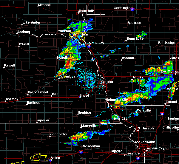 At 713 pm cdt, a severe thunderstorm capable of producing a tornado was located 7 miles northwest of tarkio, moving east at 30 mph (radar indicated rotation). Hazards include tornado and quarter size hail. Flying debris will be dangerous to those caught without shelter. mobile homes will be damaged or destroyed. damage to roofs, windows, and vehicles will occur. Tree damage is likely. At 713 pm cdt, a severe thunderstorm capable of producing a tornado was located 7 miles northwest of tarkio, moving east at 30 mph (radar indicated rotation). Hazards include tornado and quarter size hail. Flying debris will be dangerous to those caught without shelter. mobile homes will be damaged or destroyed. damage to roofs, windows, and vehicles will occur. Tree damage is likely.
|
| 3/6/2017 5:36 PM CST | Golf Ball sized hail reported 3.1 miles E of Westboro, MO, . |
| 3/6/2017 5:34 PM CST | Quarter sized hail reported 4.3 miles ESE of Westboro, MO, dispatch relayed report of 1 inch size hail approx. 1 mile south of the ia border on us hwy 59. |
| 9/9/2016 6:39 PM CDT |
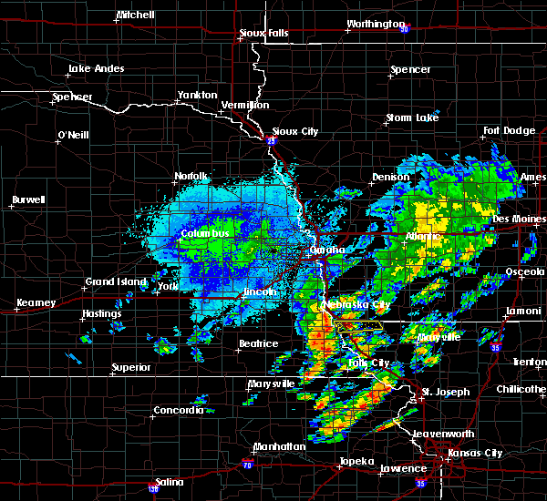 At 638 pm cdt, a severe thunderstorm was located near hamburg, or 14 miles northwest of tarkio, moving east at 40 mph (radar indicated). Hazards include 60 mph wind gusts and quarter size hail. Hail damage to vehicles is expected. Expect wind damage to roofs, siding, and trees. At 638 pm cdt, a severe thunderstorm was located near hamburg, or 14 miles northwest of tarkio, moving east at 40 mph (radar indicated). Hazards include 60 mph wind gusts and quarter size hail. Hail damage to vehicles is expected. Expect wind damage to roofs, siding, and trees.
|
| 8/28/2016 5:42 PM CDT |
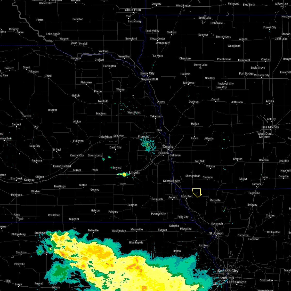 The severe thunderstorm warning for northeastern atchison county will expire at 545 pm cdt, the storm which prompted the warning has weakened below severe limits and exited the warned area. therefore the warning will be allowed to expire. The severe thunderstorm warning for northeastern atchison county will expire at 545 pm cdt, the storm which prompted the warning has weakened below severe limits and exited the warned area. therefore the warning will be allowed to expire.
|
| 8/28/2016 5:33 PM CDT |
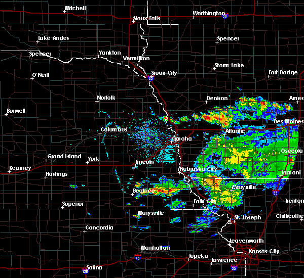 At 533 pm cdt, a severe thunderstorm was located over blanchard, or 12 miles northeast of tarkio, moving northeast at 25 mph (radar indicated). Hazards include 60 mph wind gusts and nickel size hail. Expect damage to roofs. siding. and trees. Locations impacted include, westboro and blanchard. At 533 pm cdt, a severe thunderstorm was located over blanchard, or 12 miles northeast of tarkio, moving northeast at 25 mph (radar indicated). Hazards include 60 mph wind gusts and nickel size hail. Expect damage to roofs. siding. and trees. Locations impacted include, westboro and blanchard.
|
| 8/28/2016 5:27 PM CDT |
 At 526 pm cdt, a severe thunderstorm was located over blanchard, or 9 miles northeast of tarkio, moving northeast at 25 mph (radar indicated). Hazards include 60 mph wind gusts and nickel size hail. Expect damage to roofs. siding. and trees. Locations impacted include, tarkio, westboro and blanchard. At 526 pm cdt, a severe thunderstorm was located over blanchard, or 9 miles northeast of tarkio, moving northeast at 25 mph (radar indicated). Hazards include 60 mph wind gusts and nickel size hail. Expect damage to roofs. siding. and trees. Locations impacted include, tarkio, westboro and blanchard.
|
| 8/28/2016 5:20 PM CDT |
 At 519 pm cdt, a severe thunderstorm was located near tarkio, moving northeast at 25 mph. at 511 pm 60 mph wind gusts were reported in tarkio (radar indicated). Hazards include 60 mph wind gusts and nickel size hail. Expect damage to roofs. siding. and trees. Locations impacted include, tarkio, rock port, rockport, westboro and blanchard. At 519 pm cdt, a severe thunderstorm was located near tarkio, moving northeast at 25 mph. at 511 pm 60 mph wind gusts were reported in tarkio (radar indicated). Hazards include 60 mph wind gusts and nickel size hail. Expect damage to roofs. siding. and trees. Locations impacted include, tarkio, rock port, rockport, westboro and blanchard.
|
| 8/28/2016 5:08 PM CDT |
 At 508 pm cdt, a severe thunderstorm was located near tarkio, moving northeast at 25 mph (radar indicated). Hazards include 60 mph wind gusts and nickel size hail. Expect damage to roofs. siding. And trees. At 508 pm cdt, a severe thunderstorm was located near tarkio, moving northeast at 25 mph (radar indicated). Hazards include 60 mph wind gusts and nickel size hail. Expect damage to roofs. siding. And trees.
|
| 8/24/2016 12:56 AM CDT |
 The severe thunderstorm warning for atchison, northern andrew, northwestern gentry, western worth, nodaway and holt counties will expire at 100 am cdt, the storms which prompted the warning have weakened below severe limits, and no longer pose an immediate threat to life or property. therefore the warning will be allowed to expire. however gusty winds and heavy rain are still possible with these thunderstorms. to report severe weather, contact your nearest law enforcement agency. they will relay your report to the national weather service pleasant hill. The severe thunderstorm warning for atchison, northern andrew, northwestern gentry, western worth, nodaway and holt counties will expire at 100 am cdt, the storms which prompted the warning have weakened below severe limits, and no longer pose an immediate threat to life or property. therefore the warning will be allowed to expire. however gusty winds and heavy rain are still possible with these thunderstorms. to report severe weather, contact your nearest law enforcement agency. they will relay your report to the national weather service pleasant hill.
|
| 8/24/2016 12:15 AM CDT |
 At 1214 am cdt, severe thunderstorms were located along a line extending from 11 miles north of bedford to near tarkio to near auburn, moving south at 40 mph (radar indicated). Hazards include 60 mph wind gusts. Expect damage to roofs. siding. And trees. At 1214 am cdt, severe thunderstorms were located along a line extending from 11 miles north of bedford to near tarkio to near auburn, moving south at 40 mph (radar indicated). Hazards include 60 mph wind gusts. Expect damage to roofs. siding. And trees.
|
| 7/7/2016 3:54 AM CDT |
 The severe thunderstorm warning for eastern atchison and northwestern holt counties will expire at 400 am cdt, the storms which prompted the warning have moved out of the area. therefore the warning will be allowed to expire. a severe thunderstorm watch remains in effect until 900 am cdt for northwestern missouri. The severe thunderstorm warning for eastern atchison and northwestern holt counties will expire at 400 am cdt, the storms which prompted the warning have moved out of the area. therefore the warning will be allowed to expire. a severe thunderstorm watch remains in effect until 900 am cdt for northwestern missouri.
|
| 7/7/2016 3:42 AM CDT |
 At 341 am cdt, severe thunderstorms were located along a line extending from near blanchard to near tarkio to 7 miles west of maitland to 6 miles southwest of mound city, moving east at 50 mph. this storm has knocked tree limbs down in the town of fairfax (emergency management). Hazards include 70 mph wind gusts. Expect considerable tree damage. Damage is likely to mobile homes, roofs, and outbuildings. At 341 am cdt, severe thunderstorms were located along a line extending from near blanchard to near tarkio to 7 miles west of maitland to 6 miles southwest of mound city, moving east at 50 mph. this storm has knocked tree limbs down in the town of fairfax (emergency management). Hazards include 70 mph wind gusts. Expect considerable tree damage. Damage is likely to mobile homes, roofs, and outbuildings.
|
| 7/7/2016 3:24 AM CDT |
 At 322 am cdt, severe thunderstorms were located along a line extending from 6 miles north of tarkio to near rockport to near craig to near falls city, moving east at 60 mph. law enforcement in rockport also reported high winds and observing equipment in falls city nebraska recorded a 68 mph wind gust (radar indicated). Hazards include 70 mph wind gusts and penny size hail. Expect considerable tree damage. damage is likely to mobile homes, roofs, and outbuildings. locations impacted include, tarkio, mound city, rock port, fairfax, craig, rockport, big lake, westboro, watson, blanchard, fortescue, bigelow, corning, indian cave state park and phelps city. This includes interstate 29 between mile markers 78 and 123. At 322 am cdt, severe thunderstorms were located along a line extending from 6 miles north of tarkio to near rockport to near craig to near falls city, moving east at 60 mph. law enforcement in rockport also reported high winds and observing equipment in falls city nebraska recorded a 68 mph wind gust (radar indicated). Hazards include 70 mph wind gusts and penny size hail. Expect considerable tree damage. damage is likely to mobile homes, roofs, and outbuildings. locations impacted include, tarkio, mound city, rock port, fairfax, craig, rockport, big lake, westboro, watson, blanchard, fortescue, bigelow, corning, indian cave state park and phelps city. This includes interstate 29 between mile markers 78 and 123.
|
| 7/7/2016 3:17 AM CDT |
 At 316 am cdt, severe thunderstorms were located along a line extending from near hamburg to near rock port to 7 miles southwest of fairfax to near falls city, moving east at 65 mph (radar indicated). Hazards include 70 mph wind gusts and nickel size hail. Expect considerable tree damage. damage is likely to mobile homes, roofs, and outbuildings. locations impacted include, tarkio, mound city, rock port, fairfax, craig, rockport, big lake, westboro, watson, blanchard, fortescue, bigelow, corning, indian cave state park and phelps city. This includes interstate 29 between mile markers 78 and 123. At 316 am cdt, severe thunderstorms were located along a line extending from near hamburg to near rock port to 7 miles southwest of fairfax to near falls city, moving east at 65 mph (radar indicated). Hazards include 70 mph wind gusts and nickel size hail. Expect considerable tree damage. damage is likely to mobile homes, roofs, and outbuildings. locations impacted include, tarkio, mound city, rock port, fairfax, craig, rockport, big lake, westboro, watson, blanchard, fortescue, bigelow, corning, indian cave state park and phelps city. This includes interstate 29 between mile markers 78 and 123.
|
| 7/7/2016 3:05 AM CDT |
 At 304 am cdt, severe thunderstorms were located along a line extending from near hamburg to near peru to near shubert, moving east at 55 mph (radar indicated). Hazards include 70 mph wind gusts and nickel size hail. Expect considerable tree damage. damage is likely to mobile homes, roofs, and outbuildings. locations impacted include, tarkio, mound city, rock port, fairfax, craig, rockport, big lake, westboro, watson, blanchard, fortescue, bigelow, corning, indian cave state park and phelps city. This includes interstate 29 between mile markers 78 and 123. At 304 am cdt, severe thunderstorms were located along a line extending from near hamburg to near peru to near shubert, moving east at 55 mph (radar indicated). Hazards include 70 mph wind gusts and nickel size hail. Expect considerable tree damage. damage is likely to mobile homes, roofs, and outbuildings. locations impacted include, tarkio, mound city, rock port, fairfax, craig, rockport, big lake, westboro, watson, blanchard, fortescue, bigelow, corning, indian cave state park and phelps city. This includes interstate 29 between mile markers 78 and 123.
|
| 7/7/2016 2:51 AM CDT |
 At 250 am cdt, severe thunderstorms were located along a line extending from near nebraska city to near johnson to near table rock, moving east at 55 mph (radar indicated). Hazards include 70 mph wind gusts and nickel size hail. Expect considerable tree damage. Damage is likely to mobile homes, roofs, and outbuildings. At 250 am cdt, severe thunderstorms were located along a line extending from near nebraska city to near johnson to near table rock, moving east at 55 mph (radar indicated). Hazards include 70 mph wind gusts and nickel size hail. Expect considerable tree damage. Damage is likely to mobile homes, roofs, and outbuildings.
|
| 5/30/2016 6:52 PM CDT |
 At 652 pm cdt, a severe thunderstorm was located near rock port, or 12 miles west of tarkio, moving northeast at 15 mph (radar indicated). Hazards include quarter size hail. damage to vehicles is expected At 652 pm cdt, a severe thunderstorm was located near rock port, or 12 miles west of tarkio, moving northeast at 15 mph (radar indicated). Hazards include quarter size hail. damage to vehicles is expected
|
| 5/9/2016 6:18 PM CDT |
 At 617 pm cdt, a severe thunderstorm was located near tarkio, moving north at 10 mph (trained weather spotters report half dollar sized hail near westboro). Hazards include 60 mph wind gusts and half dollar size hail. Hail damage to vehicles is expected. expect wind damage to roofs, siding, and trees. Locations impacted include, tarkio, westboro and blanchard. At 617 pm cdt, a severe thunderstorm was located near tarkio, moving north at 10 mph (trained weather spotters report half dollar sized hail near westboro). Hazards include 60 mph wind gusts and half dollar size hail. Hail damage to vehicles is expected. expect wind damage to roofs, siding, and trees. Locations impacted include, tarkio, westboro and blanchard.
|
| 5/9/2016 6:17 PM CDT | Half Dollar sized hail reported 0.4 miles NNW of Westboro, MO |
| 5/9/2016 6:14 PM CDT | Quarter sized hail reported 2.1 miles E of Westboro, MO |
| 5/9/2016 6:07 PM CDT |
 At 606 pm cdt, a severe thunderstorm was located near tarkio, moving north at 10 mph (trained weather spotters reported quarter sized hail 3 miles north of tarkio). Hazards include 60 mph wind gusts and quarter size hail. Hail damage to vehicles is expected. expect wind damage to roofs, siding, and trees. Locations impacted include, tarkio, westboro and blanchard. At 606 pm cdt, a severe thunderstorm was located near tarkio, moving north at 10 mph (trained weather spotters reported quarter sized hail 3 miles north of tarkio). Hazards include 60 mph wind gusts and quarter size hail. Hail damage to vehicles is expected. expect wind damage to roofs, siding, and trees. Locations impacted include, tarkio, westboro and blanchard.
|
| 5/9/2016 5:54 PM CDT |
 At 554 pm cdt, a severe thunderstorm was located over tarkio, moving north at 10 mph (radar indicated). Hazards include 60 mph wind gusts and quarter size hail. Hail damage to vehicles is expected. Expect wind damage to roofs, siding, and trees. At 554 pm cdt, a severe thunderstorm was located over tarkio, moving north at 10 mph (radar indicated). Hazards include 60 mph wind gusts and quarter size hail. Hail damage to vehicles is expected. Expect wind damage to roofs, siding, and trees.
|
| 9/8/2015 3:28 AM CDT |
 At 327 am cdt, severe thunderstorms were located along a line extending from near blanchard to near tarkio to rockport, moving southeast at 45 mph (radar indicated). Hazards include 70 mph wind gusts. Expect considerable tree damage. damage is likely to mobile homes, roofs and outbuildings. locations impacted include, tarkio, rock port, fairfax, rockport, elmo, westboro and blanchard. This includes interstate 29 between mile markers 111 and 115. At 327 am cdt, severe thunderstorms were located along a line extending from near blanchard to near tarkio to rockport, moving southeast at 45 mph (radar indicated). Hazards include 70 mph wind gusts. Expect considerable tree damage. damage is likely to mobile homes, roofs and outbuildings. locations impacted include, tarkio, rock port, fairfax, rockport, elmo, westboro and blanchard. This includes interstate 29 between mile markers 111 and 115.
|
| 9/8/2015 3:09 AM CDT |
 At 307 am cdt, a severe thunderstorm was located near hamburg, or 15 miles northwest of tarkio, moving southeast at 40 mph (radar indicated. at 255 am cdt winds gusted to around 65 mph in nebraska city). Hazards include 70 mph wind gusts. Expect considerable tree damage. Damage is likely to mobile homes, roofs and outbuildings. At 307 am cdt, a severe thunderstorm was located near hamburg, or 15 miles northwest of tarkio, moving southeast at 40 mph (radar indicated. at 255 am cdt winds gusted to around 65 mph in nebraska city). Hazards include 70 mph wind gusts. Expect considerable tree damage. Damage is likely to mobile homes, roofs and outbuildings.
|
| 8/10/2015 2:29 AM CDT |
 At 227 am cdt, a severe thunderstorm was located over coin, or 16 miles northeast of tarkio, moving southeast at 25 mph (radar indicated). Hazards include 60 mph wind gusts and quarter size hail. Hail damage to vehicles is expected. Expect wind damage to roofs, siding and trees. At 227 am cdt, a severe thunderstorm was located over coin, or 16 miles northeast of tarkio, moving southeast at 25 mph (radar indicated). Hazards include 60 mph wind gusts and quarter size hail. Hail damage to vehicles is expected. Expect wind damage to roofs, siding and trees.
|
| 6/11/2015 4:09 PM CDT |
 At 405 pm cdt, a confirmed tornado was located 8 miles south of coin, and moving northeast at 35 mph. at 345 pm, a storm chaser reported a tornado 1 mile north of tarkio (weather spotters confirmed tornado). Hazards include damaging tornado and quarter size hail. Flying debris will be dangerous to those caught without shelter. mobile homes will be damaged or destroyed. damage to roofs, windows and vehicles will occur. Tree damage is likely. At 405 pm cdt, a confirmed tornado was located 8 miles south of coin, and moving northeast at 35 mph. at 345 pm, a storm chaser reported a tornado 1 mile north of tarkio (weather spotters confirmed tornado). Hazards include damaging tornado and quarter size hail. Flying debris will be dangerous to those caught without shelter. mobile homes will be damaged or destroyed. damage to roofs, windows and vehicles will occur. Tree damage is likely.
|
| 6/11/2015 3:57 PM CDT |
 At 355 pm cdt, a severe thunderstorm capable of producing a tornado was located 7 miles northeast of tarkio, and moving northeast at 35 mph (radar indicated rotation). Hazards include tornado. Flying debris will be dangerous to those caught without shelter. mobile homes will be damaged or destroyed. damage to roofs, windows and vehicles will occur. Tree damage is likely. At 355 pm cdt, a severe thunderstorm capable of producing a tornado was located 7 miles northeast of tarkio, and moving northeast at 35 mph (radar indicated rotation). Hazards include tornado. Flying debris will be dangerous to those caught without shelter. mobile homes will be damaged or destroyed. damage to roofs, windows and vehicles will occur. Tree damage is likely.
|
| 6/11/2015 3:48 PM CDT |
 At 347 pm cdt, a severe thunderstorm capable of producing a tornado was located near tarkio, and moving east at 15 mph (radar indicated rotation). Hazards include tornado and quarter size hail. Flying debris will be dangerous to those caught without shelter. mobile homes will be damaged or destroyed. damage to roofs, windows and vehicles will occur. tree damage is likely. Locations impacted include, westboro. At 347 pm cdt, a severe thunderstorm capable of producing a tornado was located near tarkio, and moving east at 15 mph (radar indicated rotation). Hazards include tornado and quarter size hail. Flying debris will be dangerous to those caught without shelter. mobile homes will be damaged or destroyed. damage to roofs, windows and vehicles will occur. tree damage is likely. Locations impacted include, westboro.
|
| 6/11/2015 3:36 PM CDT |
 At 333 pm cdt, a severe thunderstorm capable of producing a tornado was located near tarkio, and moving east at 15 mph (radar indicated rotation). Hazards include tornado and quarter size hail. Flying debris will be dangerous to those caught without shelter. mobile homes will be damaged or destroyed. damage to roofs, windows and vehicles will occur. Tree damage is likely. At 333 pm cdt, a severe thunderstorm capable of producing a tornado was located near tarkio, and moving east at 15 mph (radar indicated rotation). Hazards include tornado and quarter size hail. Flying debris will be dangerous to those caught without shelter. mobile homes will be damaged or destroyed. damage to roofs, windows and vehicles will occur. Tree damage is likely.
|
| 6/4/2015 8:38 AM CDT | At 807 am, the public reported a 60.00 mph wind gust 10 miles southwest of rockport. at 835 am cdt, severe thunderstorms were located along a line extending from 8 miles west of burlington junction to 5 miles east of reserve, and moving east at 30 mph (radar indicated). Hazards include 60 mph wind gusts and quarter size hail. Hail damage to vehicles is expected. expect wind damage to roofs, siding and trees. locations impacted include, mound city, burlington junction, white cloud, skidmore, maitland, forest city, oregon, big lake, bigelow, elmo, fortescue, clearmont, quitman, iowa point and graham. This will impact i-29 between mile markers 72 and 94. |
| 6/4/2015 8:38 AM CDT | At 807 am, the public reported a 60.00 mph wind gust 10 miles southwest of rockport. at 835 am cdt, severe thunderstorms were located along a line extending from 8 miles west of burlington junction to 5 miles east of reserve, and moving east at 30 mph (radar indicated). Hazards include 60 mph wind gusts and quarter size hail. Hail damage to vehicles is expected. expect wind damage to roofs, siding and trees. locations impacted include, mound city, burlington junction, white cloud, skidmore, maitland, forest city, oregon, big lake, bigelow, elmo, fortescue, clearmont, quitman, iowa point and graham. This will impact i-29 between mile markers 72 and 94. |
| 6/4/2015 8:24 AM CDT | At 822 am cdt, severe thunderstorms were located along a line extending from 8 miles north of tarkio to falls city, and moving east at 30 mph. at 807 am, the public reported a 60 mph wind gust 11 miles southwest of rockport (radar indicated). Hazards include 60 mph wind gusts and quarter size hail. Hail damage to vehicles is expected. Expect wind damage to roofs, siding and trees. |
| 6/4/2015 8:24 AM CDT | At 822 am cdt, severe thunderstorms were located along a line extending from 8 miles north of tarkio to falls city, and moving east at 30 mph. at 807 am, the public reported a 60 mph wind gust 11 miles southwest of rockport (radar indicated). Hazards include 60 mph wind gusts and quarter size hail. Hail damage to vehicles is expected. Expect wind damage to roofs, siding and trees. |
| 6/3/2014 9:11 PM CDT | Quarter sized hail reported 1 miles S of Westboro, MO |
| 6/3/2014 3:35 PM CDT | Quarter sized hail reported 2.4 miles SW of Westboro, MO |
| 5/28/2013 5:41 PM CDT | Quarter sized hail reported 0.3 miles SSW of Westboro, MO |
| 5/19/2013 4:26 PM CDT | Golf Ball sized hail reported 2.1 miles E of Westboro, MO |
| 3/29/2012 8:04 PM CDT | Ping Pong Ball sized hail reported 0.3 miles SSW of Westboro, MO |
| 1/1/0001 12:00 AM | Quarter sized hail reported 0.4 miles NNW of Westboro, MO |
| 1/1/0001 12:00 AM | Quarter sized hail reported 0.3 miles SSW of Westboro, MO, heavy rain is occurring with the hail. |
Hail Maps for Westboro, MO

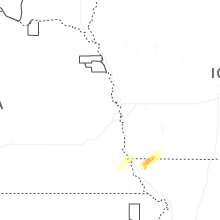
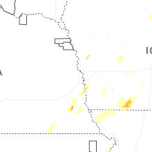


Connect with Interactive Hail Maps