

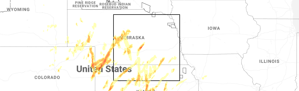
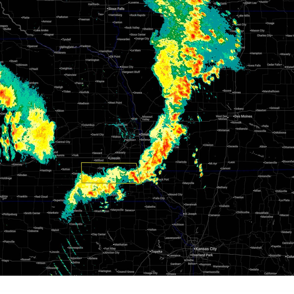
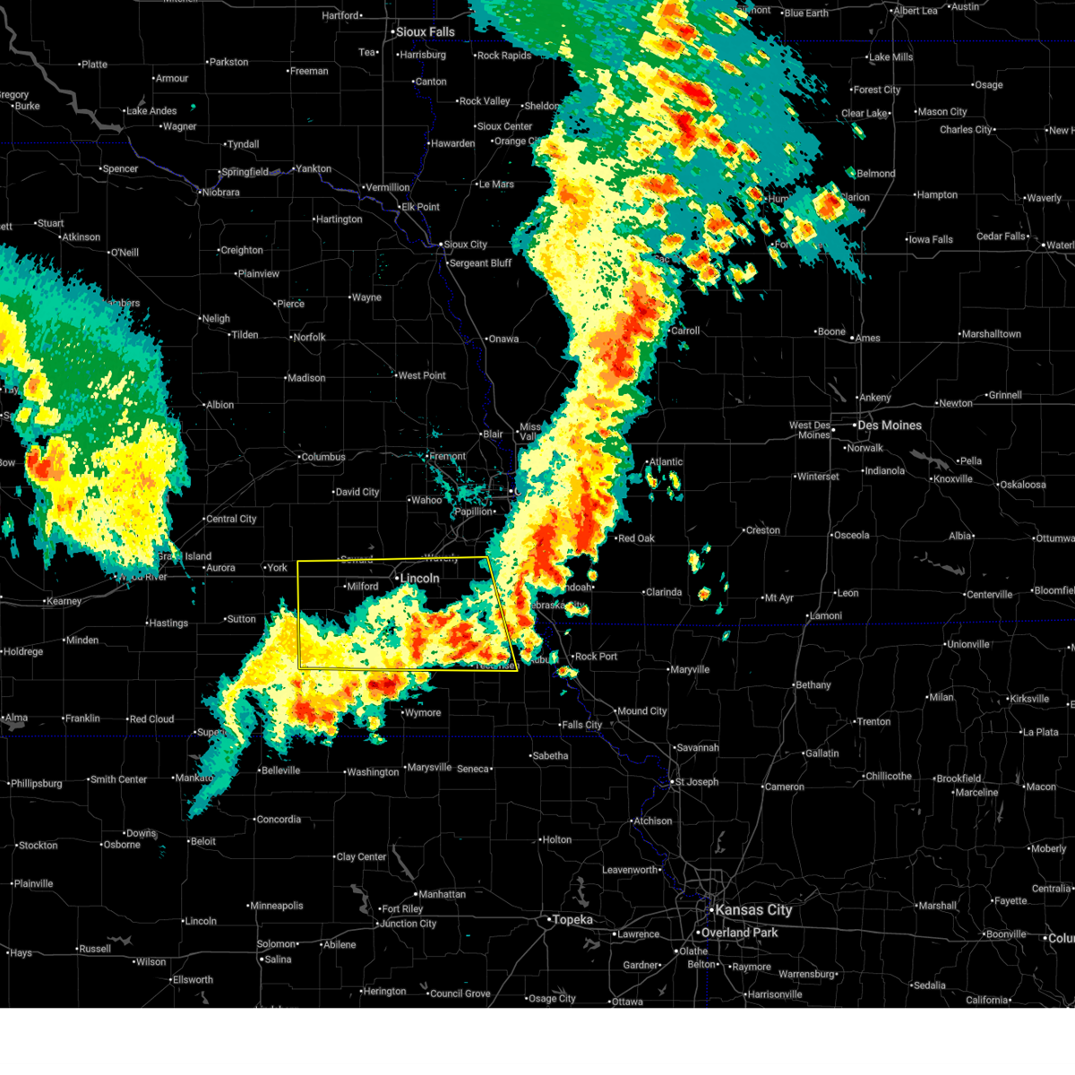
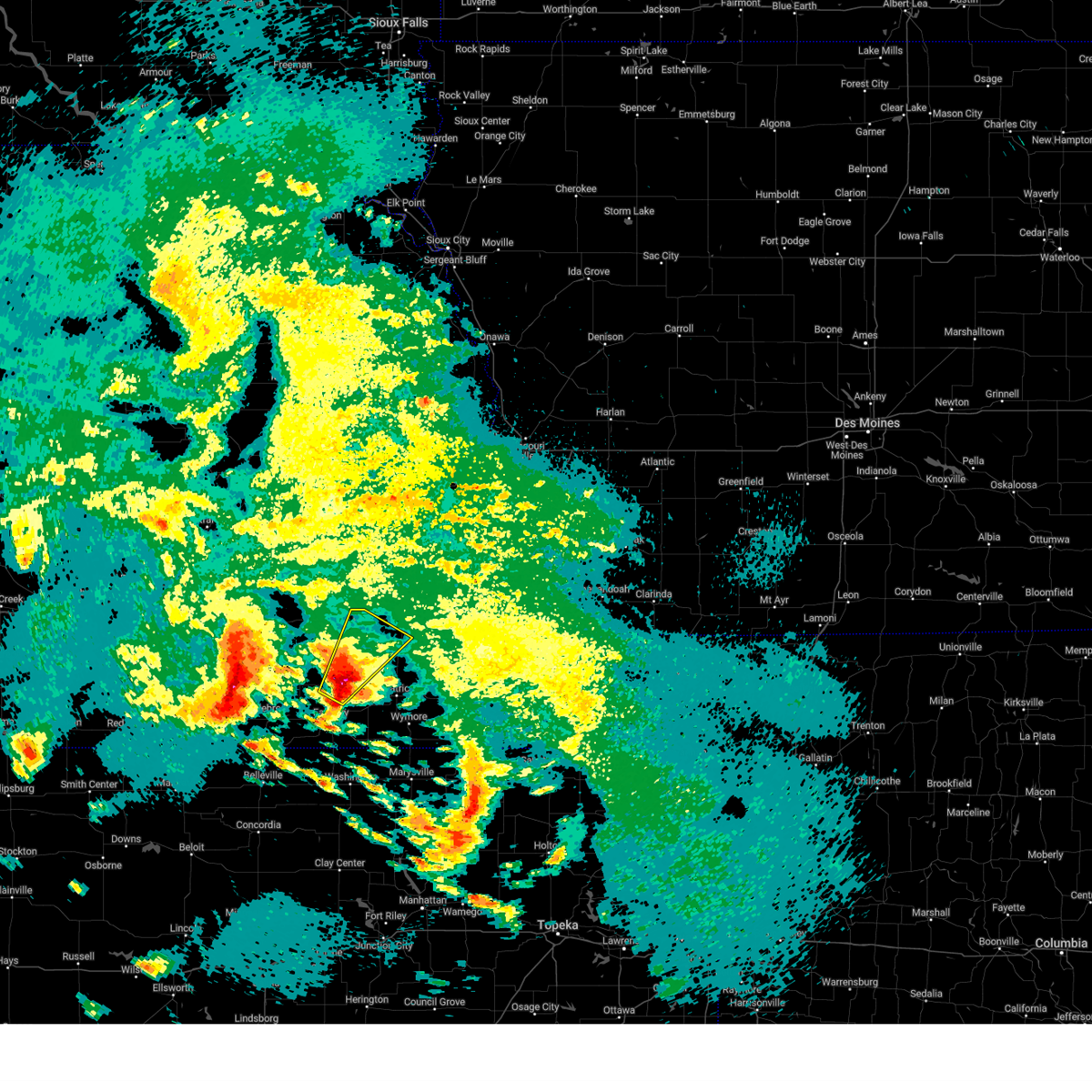
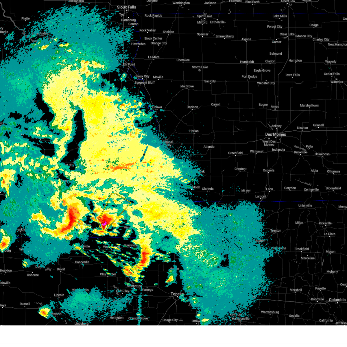
Hail Map for Western, NE
The Western, NE area has had 2 reports of on-the-ground hail by trained spotters, and has been under severe weather warnings 12 times during the past 12 months. Doppler radar has detected hail at or near Western, NE on 96 occasions, including 1 occasion during the past year.
| Name: | Western, NE |
| Where Located: | 70.4 miles ESE of Grand Island, NE |
| Map: | Google Map for Western, NE |
| Population: | 235 |
| Housing Units: | 140 |
| More Info: | Search Google for Western, NE |
0
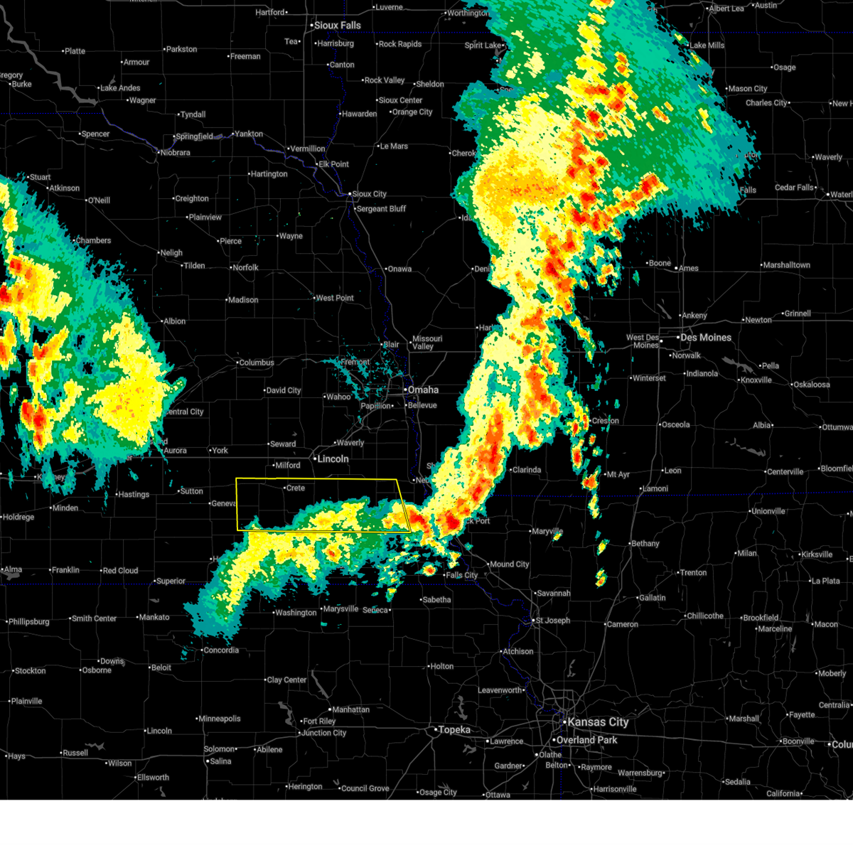
The Top Recent Hail Date for Western, NE is Sunday, May 18, 2025 (96th out of 96)
Hail and Wind Damage Spotted near Western, NE
| Date / Time | Report Details |
|---|---|
| 7/10/2025 3:59 AM CDT |
 the severe thunderstorm warning has been cancelled and is no longer in effect the severe thunderstorm warning has been cancelled and is no longer in effect
|
| 7/10/2025 3:45 AM CDT |
 the severe thunderstorm warning has been cancelled and is no longer in effect the severe thunderstorm warning has been cancelled and is no longer in effect
|
| 7/10/2025 3:45 AM CDT |
 At 344 am cdt, severe thunderstorms were located along a line extending from 3 miles west of sprague to 2 miles northwest of dunbar, moving east at 35 mph (weather instrument measurement measured wind gust of 64 mph at 3:08 am in lincoln, ne). Hazards include 60 mph wind gusts. the strongest winds are occurring behind the heaviest precipitation. Expect damage to roofs, siding, and trees. Locations impacted include, tecumseh, crete, syracuse, wilber, hickman, friend, bennet, firth, dorchester, adams, de witt, cortland, sterling, johnson, cook, unadilla, panama, western, talmage, and clatonia. At 344 am cdt, severe thunderstorms were located along a line extending from 3 miles west of sprague to 2 miles northwest of dunbar, moving east at 35 mph (weather instrument measurement measured wind gust of 64 mph at 3:08 am in lincoln, ne). Hazards include 60 mph wind gusts. the strongest winds are occurring behind the heaviest precipitation. Expect damage to roofs, siding, and trees. Locations impacted include, tecumseh, crete, syracuse, wilber, hickman, friend, bennet, firth, dorchester, adams, de witt, cortland, sterling, johnson, cook, unadilla, panama, western, talmage, and clatonia.
|
| 7/10/2025 3:35 AM CDT |
 the severe thunderstorm warning has been cancelled and is no longer in effect the severe thunderstorm warning has been cancelled and is no longer in effect
|
| 7/10/2025 3:35 AM CDT |
 At 334 am cdt, severe thunderstorms were located along a line extending from 3 miles east of crete to 3 miles northeast of syracuse, moving east at 35 mph (weather instrument measurement measured wind gust of 64 mph at 3:08 am in lincoln, ne). Hazards include 60 mph wind gusts. the strongest winds are occurring behind the heaviest precipitation. Expect damage to roofs, siding, and trees. Locations impacted include, syracuse, hickman, bennet, palmyra, unadilla, panama, roca, dunbar, douglas, sprague, firth, lorton, talmage and cook. At 334 am cdt, severe thunderstorms were located along a line extending from 3 miles east of crete to 3 miles northeast of syracuse, moving east at 35 mph (weather instrument measurement measured wind gust of 64 mph at 3:08 am in lincoln, ne). Hazards include 60 mph wind gusts. the strongest winds are occurring behind the heaviest precipitation. Expect damage to roofs, siding, and trees. Locations impacted include, syracuse, hickman, bennet, palmyra, unadilla, panama, roca, dunbar, douglas, sprague, firth, lorton, talmage and cook.
|
| 7/10/2025 3:12 AM CDT |
 Svroax the national weather service in omaha has issued a * severe thunderstorm warning for, lancaster county in southeastern nebraska, johnson county in southeastern nebraska, northwestern nemaha county in southeastern nebraska, southern seward county in southeastern nebraska, otoe county in southeastern nebraska, saline county in southeastern nebraska, northern gage county in southeastern nebraska, southwestern cass county in southeastern nebraska, * until 415 am cdt. * at 310 am cdt, severe thunderstorms were located along a line extending from near dorchester to 2 miles northeast of palmyra, moving east at 35 mph (weather instrument measurement wind gust of 64 mph at 3:08 am in lincoln, ne). Hazards include 60 mph wind gusts. the strongest winds are occurring behind the heaviest precipitation. Expect damage to roofs, siding, and trees. severe thunderstorms will be near, southeastern lincoln, crete, bennet, palmyra, unadilla, roca, and sprague around 315 am cdt. syracuse and hickman around 320 am cdt. panama around 330 am cdt. other locations in the path of these severe thunderstorms include dunbar, douglas, lorton, firth and talmage. This includes interstate 80 in nebraska between mile markers 366 and 412. Svroax the national weather service in omaha has issued a * severe thunderstorm warning for, lancaster county in southeastern nebraska, johnson county in southeastern nebraska, northwestern nemaha county in southeastern nebraska, southern seward county in southeastern nebraska, otoe county in southeastern nebraska, saline county in southeastern nebraska, northern gage county in southeastern nebraska, southwestern cass county in southeastern nebraska, * until 415 am cdt. * at 310 am cdt, severe thunderstorms were located along a line extending from near dorchester to 2 miles northeast of palmyra, moving east at 35 mph (weather instrument measurement wind gust of 64 mph at 3:08 am in lincoln, ne). Hazards include 60 mph wind gusts. the strongest winds are occurring behind the heaviest precipitation. Expect damage to roofs, siding, and trees. severe thunderstorms will be near, southeastern lincoln, crete, bennet, palmyra, unadilla, roca, and sprague around 315 am cdt. syracuse and hickman around 320 am cdt. panama around 330 am cdt. other locations in the path of these severe thunderstorms include dunbar, douglas, lorton, firth and talmage. This includes interstate 80 in nebraska between mile markers 366 and 412.
|
| 5/18/2025 10:18 PM CDT | the severe thunderstorm warning has been cancelled and is no longer in effect |
| 5/18/2025 9:54 PM CDT |
 At 954 pm cdt, a severe thunderstorm was located 4 miles north of swanton, or 19 miles northwest of beatrice, moving northeast at 35 mph (radar indicated). Hazards include 60 mph wind gusts and quarter size hail. Hail damage to vehicles is expected. expect wind damage to roofs, siding, and trees. this severe storm will be near, wilber around 1000 pm cdt. Other locations in the path of this severe thunderstorm include crete. At 954 pm cdt, a severe thunderstorm was located 4 miles north of swanton, or 19 miles northwest of beatrice, moving northeast at 35 mph (radar indicated). Hazards include 60 mph wind gusts and quarter size hail. Hail damage to vehicles is expected. expect wind damage to roofs, siding, and trees. this severe storm will be near, wilber around 1000 pm cdt. Other locations in the path of this severe thunderstorm include crete.
|
| 5/18/2025 9:42 PM CDT |
 At 942 pm cdt, a severe thunderstorm was located near swanton, or 14 miles north of fairbury, moving northeast at 35 mph (radar indicated). Hazards include ping pong ball size hail and 60 mph wind gusts. People and animals outdoors will be injured. expect hail damage to roofs, siding, windows, and vehicles. expect wind damage to roofs, siding, and trees. this severe storm will be near, swanton around 950 pm cdt. wilber around 955 pm cdt. Other locations in the path of this severe thunderstorm include crete. At 942 pm cdt, a severe thunderstorm was located near swanton, or 14 miles north of fairbury, moving northeast at 35 mph (radar indicated). Hazards include ping pong ball size hail and 60 mph wind gusts. People and animals outdoors will be injured. expect hail damage to roofs, siding, windows, and vehicles. expect wind damage to roofs, siding, and trees. this severe storm will be near, swanton around 950 pm cdt. wilber around 955 pm cdt. Other locations in the path of this severe thunderstorm include crete.
|
| 5/18/2025 9:37 PM CDT | Svroax the national weather service in omaha has issued a * severe thunderstorm warning for, southwestern lancaster county in southeastern nebraska, northwestern jefferson county in southeastern nebraska, eastern saline county in southeastern nebraska, northwestern gage county in southeastern nebraska, * until 1030 pm cdt. * at 937 pm cdt, a severe thunderstorm was located 5 miles southwest of swanton, or 11 miles north of fairbury, moving northeast at 35 mph (radar indicated). Hazards include ping pong ball size hail and 60 mph wind gusts. People and animals outdoors will be injured. expect hail damage to roofs, siding, windows, and vehicles. expect wind damage to roofs, siding, and trees. this severe thunderstorm will be near, swanton around 945 pm cdt. wilber around 955 pm cdt. Other locations in the path of this severe thunderstorm include crete. |
| 7/31/2024 4:22 PM CDT | At 422 pm cdt, severe thunderstorms were located along a line extending from near staplehurst to 6 miles northwest of dorchester to 6 miles east of milligan, moving east at 40 mph (public. at 420 pm, a 63 mph gust was measured 6 miles south- southwest of friend). Hazards include 70 mph wind gusts and quarter size hail. Hail damage to vehicles is expected. expect considerable tree damage. wind damage is also likely to mobile homes, roofs, and outbuildings. Locations impacted include, seward, crete, milford, wilber, friend, utica, dorchester, de witt, beaver crossing, staplehurst, western, garland, pleasant dale, dwight, bee, ulysses, goehner, cordova, tobias, and swanton. |
| 7/31/2024 3:52 PM CDT |
 Svroax the national weather service in omaha has issued a * severe thunderstorm warning for, seward county in southeastern nebraska, saline county in southeastern nebraska, southern butler county in east central nebraska, * until 500 pm cdt. * at 351 pm cdt, severe thunderstorms were located along a line extending from 4 miles southeast of benedict to mccool junction to near geneva, moving east at 35 mph (radar indicated). Hazards include 60 mph wind gusts and half dollar size hail. Hail damage to vehicles is expected. Expect wind damage to roofs, siding, and trees. Svroax the national weather service in omaha has issued a * severe thunderstorm warning for, seward county in southeastern nebraska, saline county in southeastern nebraska, southern butler county in east central nebraska, * until 500 pm cdt. * at 351 pm cdt, severe thunderstorms were located along a line extending from 4 miles southeast of benedict to mccool junction to near geneva, moving east at 35 mph (radar indicated). Hazards include 60 mph wind gusts and half dollar size hail. Hail damage to vehicles is expected. Expect wind damage to roofs, siding, and trees.
|
| 7/6/2024 6:43 PM CDT |
 The storms which prompted the warning have moved out of the area. therefore, the warning will be allowed to expire. however, gusty winds and heavy rain are still possible with these thunderstorms. a severe thunderstorm watch remains in effect until midnight cdt for southeastern nebraska. The storms which prompted the warning have moved out of the area. therefore, the warning will be allowed to expire. however, gusty winds and heavy rain are still possible with these thunderstorms. a severe thunderstorm watch remains in effect until midnight cdt for southeastern nebraska.
|
| 7/6/2024 6:27 PM CDT |
 At 626 pm cdt, severe thunderstorms were located along a line extending from 3 miles northwest of dorchester to 2 miles southeast of swanton to 6 miles southwest of endicott, moving east at 35 mph (radar indicated). Hazards include 60 mph wind gusts and quarter size hail. Hail damage to vehicles is expected. expect wind damage to roofs, siding, and trees. Locations impacted include, fairbury, milford, friend, dorchester, western, endicott, jansen, swanton, swan creek reservoir number 2, the highway 41 and 15 south junction, swan creek wildlife management area, blue river state recreation area, crystal springs campground, camp jefferson, and willard meyer recreation area. At 626 pm cdt, severe thunderstorms were located along a line extending from 3 miles northwest of dorchester to 2 miles southeast of swanton to 6 miles southwest of endicott, moving east at 35 mph (radar indicated). Hazards include 60 mph wind gusts and quarter size hail. Hail damage to vehicles is expected. expect wind damage to roofs, siding, and trees. Locations impacted include, fairbury, milford, friend, dorchester, western, endicott, jansen, swanton, swan creek reservoir number 2, the highway 41 and 15 south junction, swan creek wildlife management area, blue river state recreation area, crystal springs campground, camp jefferson, and willard meyer recreation area.
|
| 7/6/2024 6:25 PM CDT | Storm damage reported in saline county NE, 0.9 miles SE of Western, NE |
| 7/6/2024 6:06 PM CDT |
 At 606 pm cdt, severe thunderstorms were located along a line extending from 2 miles west of cordova to 2 miles southeast of tobias to 3 miles southwest of reynolds, moving east at 50 mph (radar indicated). Hazards include ping pong ball size hail and 60 mph wind gusts. People and animals outdoors will be injured. expect hail damage to roofs, siding, windows, and vehicles. expect wind damage to roofs, siding, and trees. Locations impacted include, fairbury, milford, friend, dorchester, western, daykin, cordova, endicott, jansen, tobias, swanton, reynolds, swan creek reservoir number 2, the highway 41 and 15 south junction, swan creek wildlife management area, alexandria state recreation area, blue river state recreation area, crystal springs campground, buckley creek recreational area, and camp jefferson. At 606 pm cdt, severe thunderstorms were located along a line extending from 2 miles west of cordova to 2 miles southeast of tobias to 3 miles southwest of reynolds, moving east at 50 mph (radar indicated). Hazards include ping pong ball size hail and 60 mph wind gusts. People and animals outdoors will be injured. expect hail damage to roofs, siding, windows, and vehicles. expect wind damage to roofs, siding, and trees. Locations impacted include, fairbury, milford, friend, dorchester, western, daykin, cordova, endicott, jansen, tobias, swanton, reynolds, swan creek reservoir number 2, the highway 41 and 15 south junction, swan creek wildlife management area, alexandria state recreation area, blue river state recreation area, crystal springs campground, buckley creek recreational area, and camp jefferson.
|
| 7/6/2024 5:49 PM CDT |
 Svroax the national weather service in omaha has issued a * severe thunderstorm warning for, jefferson county in southeastern nebraska, southwestern seward county in southeastern nebraska, saline county in southeastern nebraska, * until 645 pm cdt. * at 549 pm cdt, severe thunderstorms were located along a line extending from 3 miles southeast of lushton to 2 miles north of bruning to 3 miles west of chester, moving east at 25 mph (radar indicated). Hazards include ping pong ball size hail and 60 mph wind gusts. People and animals outdoors will be injured. expect hail damage to roofs, siding, windows, and vehicles. Expect wind damage to roofs, siding, and trees. Svroax the national weather service in omaha has issued a * severe thunderstorm warning for, jefferson county in southeastern nebraska, southwestern seward county in southeastern nebraska, saline county in southeastern nebraska, * until 645 pm cdt. * at 549 pm cdt, severe thunderstorms were located along a line extending from 3 miles southeast of lushton to 2 miles north of bruning to 3 miles west of chester, moving east at 25 mph (radar indicated). Hazards include ping pong ball size hail and 60 mph wind gusts. People and animals outdoors will be injured. expect hail damage to roofs, siding, windows, and vehicles. Expect wind damage to roofs, siding, and trees.
|
| 6/26/2024 1:35 AM CDT |
 At 135 am cdt, severe thunderstorms were located along a line extending from 4 miles northwest of sprague to 2 miles south of western, moving southeast at 65 mph (public weather stations measured 55 to 65 mph winds at multiple locations in seward and saline counties with these storms). Hazards include 60 mph wind gusts. Expect damage to roofs, siding, and trees. Locations impacted include, crete, wilber, firth, de witt, cortland, plymouth, western, clatonia, hallam, daykin, sprague, tobias, swanton, swan creek reservoir number 2, the highway 41 and 15 south junction, swan creek wildlife management area, alexandria state recreation area, stagecoach state recreation area, walnut creek recreation area, and gladstone. At 135 am cdt, severe thunderstorms were located along a line extending from 4 miles northwest of sprague to 2 miles south of western, moving southeast at 65 mph (public weather stations measured 55 to 65 mph winds at multiple locations in seward and saline counties with these storms). Hazards include 60 mph wind gusts. Expect damage to roofs, siding, and trees. Locations impacted include, crete, wilber, firth, de witt, cortland, plymouth, western, clatonia, hallam, daykin, sprague, tobias, swanton, swan creek reservoir number 2, the highway 41 and 15 south junction, swan creek wildlife management area, alexandria state recreation area, stagecoach state recreation area, walnut creek recreation area, and gladstone.
|
| 6/26/2024 1:27 AM CDT | Personal weather station measured wind gus in saline county NE, 5 miles SSW of Western, NE |
| 6/26/2024 1:27 AM CDT |
 At 125 am cdt, severe thunderstorms were located along a line extending from 3 miles southwest of pleasant dale to 2 miles north of tobias, moving southeast at 65 mph (public reported measured wind gusts of 63 mph south of milford, 59 mph 4 miles south of friend, and 52 mph in friend). Hazards include 60 mph wind gusts. Expect damage to roofs, siding, and trees. Locations impacted include, seward, crete, milford, wilber, friend, firth, dorchester, de witt, cortland, plymouth, beaver crossing, western, clatonia, hallam, pleasant dale, daykin, goehner, sprague, cordova, and tobias. At 125 am cdt, severe thunderstorms were located along a line extending from 3 miles southwest of pleasant dale to 2 miles north of tobias, moving southeast at 65 mph (public reported measured wind gusts of 63 mph south of milford, 59 mph 4 miles south of friend, and 52 mph in friend). Hazards include 60 mph wind gusts. Expect damage to roofs, siding, and trees. Locations impacted include, seward, crete, milford, wilber, friend, firth, dorchester, de witt, cortland, plymouth, beaver crossing, western, clatonia, hallam, pleasant dale, daykin, goehner, sprague, cordova, and tobias.
|
| 6/26/2024 1:11 AM CDT |
 At 109 am cdt, severe thunderstorms were located along a line extending from 4 miles north of goehner to 2 miles south of fairmont, moving southeast at 65 mph (weather instrument measurement of 55 mph at the york airport. other unofficial weather instruments have measured 60 to 65 mph recently with this storm). Hazards include 60 mph wind gusts and penny size hail. Expect damage to roofs, siding, and trees. Locations impacted include, seward, crete, milford, wilber, friend, utica, firth, dorchester, de witt, cortland, plymouth, beaver crossing, western, clatonia, hallam, pleasant dale, daykin, goehner, sprague, and cordova. At 109 am cdt, severe thunderstorms were located along a line extending from 4 miles north of goehner to 2 miles south of fairmont, moving southeast at 65 mph (weather instrument measurement of 55 mph at the york airport. other unofficial weather instruments have measured 60 to 65 mph recently with this storm). Hazards include 60 mph wind gusts and penny size hail. Expect damage to roofs, siding, and trees. Locations impacted include, seward, crete, milford, wilber, friend, utica, firth, dorchester, de witt, cortland, plymouth, beaver crossing, western, clatonia, hallam, pleasant dale, daykin, goehner, sprague, and cordova.
|
| 6/26/2024 12:57 AM CDT |
 Svroax the national weather service in omaha has issued a * severe thunderstorm warning for, southwestern lancaster county in southeastern nebraska, northern jefferson county in southeastern nebraska, seward county in southeastern nebraska, saline county in southeastern nebraska, northwestern gage county in southeastern nebraska, * until 145 am cdt. * at 1256 am cdt, severe thunderstorms were located along a line extending from 3 miles southeast of gresham to 2 miles northwest of lushton, moving southeast at 65 mph (emergency management reported 60 mph wind gusts near hampton). Hazards include 60 mph wind gusts and penny size hail. expect damage to roofs, siding, and trees Svroax the national weather service in omaha has issued a * severe thunderstorm warning for, southwestern lancaster county in southeastern nebraska, northern jefferson county in southeastern nebraska, seward county in southeastern nebraska, saline county in southeastern nebraska, northwestern gage county in southeastern nebraska, * until 145 am cdt. * at 1256 am cdt, severe thunderstorms were located along a line extending from 3 miles southeast of gresham to 2 miles northwest of lushton, moving southeast at 65 mph (emergency management reported 60 mph wind gusts near hampton). Hazards include 60 mph wind gusts and penny size hail. expect damage to roofs, siding, and trees
|
| 6/18/2024 6:13 PM CDT |
 The storms which prompted the warning have weakened below severe limits, and have exited the warned area. therefore, the warning will be allowed to expire. a severe thunderstorm watch remains in effect until 800 pm cdt for southeastern nebraska. to report severe weather, contact your nearest law enforcement agency. they will relay your report to the national weather service omaha. The storms which prompted the warning have weakened below severe limits, and have exited the warned area. therefore, the warning will be allowed to expire. a severe thunderstorm watch remains in effect until 800 pm cdt for southeastern nebraska. to report severe weather, contact your nearest law enforcement agency. they will relay your report to the national weather service omaha.
|
| 6/18/2024 6:03 PM CDT |
 At 603 pm cdt, severe thunderstorms were located along a line extending from 2 miles west of crete to 4 miles east of milligan, moving east at 55 mph (radar indicated). Hazards include 60 mph wind gusts. Expect damage to roofs, siding, and trees. Locations impacted include, crete, milford, wilber, dorchester, de witt, western, pleasant dale, tobias, swanton, swan creek reservoir number 2, the highway 41 and 15 south junction, swan creek wildlife management area, blue river state recreation area, walnut creek recreation area, and willard meyer recreation area. At 603 pm cdt, severe thunderstorms were located along a line extending from 2 miles west of crete to 4 miles east of milligan, moving east at 55 mph (radar indicated). Hazards include 60 mph wind gusts. Expect damage to roofs, siding, and trees. Locations impacted include, crete, milford, wilber, dorchester, de witt, western, pleasant dale, tobias, swanton, swan creek reservoir number 2, the highway 41 and 15 south junction, swan creek wildlife management area, blue river state recreation area, walnut creek recreation area, and willard meyer recreation area.
|
| 6/18/2024 6:03 PM CDT |
 the severe thunderstorm warning has been cancelled and is no longer in effect the severe thunderstorm warning has been cancelled and is no longer in effect
|
| 6/18/2024 5:36 PM CDT |
 Svroax the national weather service in omaha has issued a * severe thunderstorm warning for, northern jefferson county in southeastern nebraska, southern seward county in southeastern nebraska, saline county in southeastern nebraska, * until 615 pm cdt. * at 536 pm cdt, severe thunderstorms were located along a line extending from 4 miles southeast of fairmont to 2 miles east of strang, moving east at 35 mph (radar indicated). Hazards include 60 mph wind gusts. expect damage to roofs, siding, and trees Svroax the national weather service in omaha has issued a * severe thunderstorm warning for, northern jefferson county in southeastern nebraska, southern seward county in southeastern nebraska, saline county in southeastern nebraska, * until 615 pm cdt. * at 536 pm cdt, severe thunderstorms were located along a line extending from 4 miles southeast of fairmont to 2 miles east of strang, moving east at 35 mph (radar indicated). Hazards include 60 mph wind gusts. expect damage to roofs, siding, and trees
|
| 6/15/2024 5:20 PM CDT |
 At 519 pm cdt, severe thunderstorms were located along a line extending from 6 miles south of dorchester to 5 miles west of plymouth, moving northeast at 40 mph (radar indicated). Hazards include 60 mph wind gusts. Expect damage to roofs, siding, and trees. Locations impacted include, crete, wilber, de witt, plymouth, western, clatonia, hallam, sprague, swanton, pioneers park, the highway 41 and 15 south junction, yankee hill lake, swan creek wildlife management area, walnut creek recreation area, olive creek state recreation area, and bluestem state recreation area. At 519 pm cdt, severe thunderstorms were located along a line extending from 6 miles south of dorchester to 5 miles west of plymouth, moving northeast at 40 mph (radar indicated). Hazards include 60 mph wind gusts. Expect damage to roofs, siding, and trees. Locations impacted include, crete, wilber, de witt, plymouth, western, clatonia, hallam, sprague, swanton, pioneers park, the highway 41 and 15 south junction, yankee hill lake, swan creek wildlife management area, walnut creek recreation area, olive creek state recreation area, and bluestem state recreation area.
|
| 6/15/2024 5:19 PM CDT |
 At 519 pm cdt, severe thunderstorms were located along a line extending from 5 miles north of western to 3 miles northwest of fairbury, moving northeast at 20 mph (radar indicated). Hazards include 60 mph wind gusts. Expect damage to roofs, siding, and trees. Locations impacted include, western and the highway 41 and 15 south junction. At 519 pm cdt, severe thunderstorms were located along a line extending from 5 miles north of western to 3 miles northwest of fairbury, moving northeast at 20 mph (radar indicated). Hazards include 60 mph wind gusts. Expect damage to roofs, siding, and trees. Locations impacted include, western and the highway 41 and 15 south junction.
|
| 6/15/2024 5:07 PM CDT |
 Svroax the national weather service in omaha has issued a * severe thunderstorm warning for, southwestern lancaster county in southeastern nebraska, northeastern jefferson county in southeastern nebraska, eastern saline county in southeastern nebraska, northwestern gage county in southeastern nebraska, * until 545 pm cdt. * at 507 pm cdt, severe thunderstorms were located along a line extending from 6 miles north of western to 4 miles north of fairbury, moving northeast at 40 mph (radar indicated). Hazards include 60 mph wind gusts and quarter size hail. Hail damage to vehicles is expected. Expect wind damage to roofs, siding, and trees. Svroax the national weather service in omaha has issued a * severe thunderstorm warning for, southwestern lancaster county in southeastern nebraska, northeastern jefferson county in southeastern nebraska, eastern saline county in southeastern nebraska, northwestern gage county in southeastern nebraska, * until 545 pm cdt. * at 507 pm cdt, severe thunderstorms were located along a line extending from 6 miles north of western to 4 miles north of fairbury, moving northeast at 40 mph (radar indicated). Hazards include 60 mph wind gusts and quarter size hail. Hail damage to vehicles is expected. Expect wind damage to roofs, siding, and trees.
|
| 6/15/2024 5:02 PM CDT |
 At 501 pm cdt, severe thunderstorms were located along a line extending from 3 miles east of tobias to 4 miles northeast of reynolds, moving east at 20 mph (radar indicated). Hazards include 60 mph wind gusts. Expect damage to roofs, siding, and trees. Locations impacted include, western, daykin, gladstone, the highway 41 and 15 south junction, willard meyer recreation area, and alexandria state recreation area. At 501 pm cdt, severe thunderstorms were located along a line extending from 3 miles east of tobias to 4 miles northeast of reynolds, moving east at 20 mph (radar indicated). Hazards include 60 mph wind gusts. Expect damage to roofs, siding, and trees. Locations impacted include, western, daykin, gladstone, the highway 41 and 15 south junction, willard meyer recreation area, and alexandria state recreation area.
|
| 6/15/2024 4:45 PM CDT |
 Svroax the national weather service in omaha has issued a * severe thunderstorm warning for, northwestern jefferson county in southeastern nebraska, southwestern saline county in southeastern nebraska, * until 530 pm cdt. * at 444 pm cdt, severe thunderstorms were located along a line extending from 3 miles south of tobias to near reynolds, moving northeast at 20 mph (radar indicated). Hazards include 60 mph wind gusts and quarter size hail. Hail damage to vehicles is expected. Expect wind damage to roofs, siding, and trees. Svroax the national weather service in omaha has issued a * severe thunderstorm warning for, northwestern jefferson county in southeastern nebraska, southwestern saline county in southeastern nebraska, * until 530 pm cdt. * at 444 pm cdt, severe thunderstorms were located along a line extending from 3 miles south of tobias to near reynolds, moving northeast at 20 mph (radar indicated). Hazards include 60 mph wind gusts and quarter size hail. Hail damage to vehicles is expected. Expect wind damage to roofs, siding, and trees.
|
| 6/15/2024 4:12 PM CDT |
 Svroax the national weather service in omaha has issued a * severe thunderstorm warning for, northwestern jefferson county in southeastern nebraska, southwestern saline county in southeastern nebraska, * until 445 pm cdt. * at 411 pm cdt, a severe thunderstorm was located near belvidere, or 19 miles northwest of fairbury, moving northeast at 25 mph (radar indicated). Hazards include 60 mph wind gusts and half dollar size hail. Hail damage to vehicles is expected. Expect wind damage to roofs, siding, and trees. Svroax the national weather service in omaha has issued a * severe thunderstorm warning for, northwestern jefferson county in southeastern nebraska, southwestern saline county in southeastern nebraska, * until 445 pm cdt. * at 411 pm cdt, a severe thunderstorm was located near belvidere, or 19 miles northwest of fairbury, moving northeast at 25 mph (radar indicated). Hazards include 60 mph wind gusts and half dollar size hail. Hail damage to vehicles is expected. Expect wind damage to roofs, siding, and trees.
|
| 5/24/2024 1:54 AM CDT |
 Svroax the national weather service in omaha has issued a * severe thunderstorm warning for, southern lancaster county in southeastern nebraska, johnson county in southeastern nebraska, jefferson county in southeastern nebraska, southern seward county in southeastern nebraska, southwestern otoe county in southeastern nebraska, saline county in southeastern nebraska, pawnee county in southeastern nebraska, gage county in southeastern nebraska, * until 245 am cdt. * at 154 am cdt, severe thunderstorms were located along a line extending from 4 miles northwest of dorchester to 2 miles north of swanton to near mahaska, moving east at 60 mph (radar indicated). Hazards include 60 mph wind gusts and quarter size hail. Hail damage to vehicles is expected. Expect wind damage to roofs, siding, and trees. Svroax the national weather service in omaha has issued a * severe thunderstorm warning for, southern lancaster county in southeastern nebraska, johnson county in southeastern nebraska, jefferson county in southeastern nebraska, southern seward county in southeastern nebraska, southwestern otoe county in southeastern nebraska, saline county in southeastern nebraska, pawnee county in southeastern nebraska, gage county in southeastern nebraska, * until 245 am cdt. * at 154 am cdt, severe thunderstorms were located along a line extending from 4 miles northwest of dorchester to 2 miles north of swanton to near mahaska, moving east at 60 mph (radar indicated). Hazards include 60 mph wind gusts and quarter size hail. Hail damage to vehicles is expected. Expect wind damage to roofs, siding, and trees.
|
| 5/24/2024 1:21 AM CDT |
 Svroax the national weather service in omaha has issued a * severe thunderstorm warning for, lancaster county in southeastern nebraska, jefferson county in southeastern nebraska, seward county in southeastern nebraska, saline county in southeastern nebraska, southern butler county in east central nebraska, southwestern saunders county in east central nebraska, western gage county in southeastern nebraska, * until 200 am cdt. * at 121 am cdt, severe thunderstorms were located along a line extending from 3 miles northeast of gresham to 4 miles northwest of hebron, moving east at 55 mph (radar indicated). Hazards include 70 mph wind gusts and quarter size hail. Hail damage to vehicles is expected. expect considerable tree damage. Wind damage is also likely to mobile homes, roofs, and outbuildings. Svroax the national weather service in omaha has issued a * severe thunderstorm warning for, lancaster county in southeastern nebraska, jefferson county in southeastern nebraska, seward county in southeastern nebraska, saline county in southeastern nebraska, southern butler county in east central nebraska, southwestern saunders county in east central nebraska, western gage county in southeastern nebraska, * until 200 am cdt. * at 121 am cdt, severe thunderstorms were located along a line extending from 3 miles northeast of gresham to 4 miles northwest of hebron, moving east at 55 mph (radar indicated). Hazards include 70 mph wind gusts and quarter size hail. Hail damage to vehicles is expected. expect considerable tree damage. Wind damage is also likely to mobile homes, roofs, and outbuildings.
|
| 5/19/2024 6:04 AM CDT |
 the severe thunderstorm warning has been cancelled and is no longer in effect the severe thunderstorm warning has been cancelled and is no longer in effect
|
| 5/19/2024 5:55 AM CDT |
 Svroax the national weather service in omaha has issued a * severe thunderstorm warning for, southwestern lancaster county in southeastern nebraska, northeastern jefferson county in southeastern nebraska, eastern saline county in southeastern nebraska, northwestern gage county in southeastern nebraska, * until 630 am cdt. * at 554 am cdt, a severe thunderstorm was located 4 miles west of wilber, or 20 miles northwest of beatrice, moving northeast at 45 mph (radar indicated). Hazards include quarter size hail. damage to vehicles is expected Svroax the national weather service in omaha has issued a * severe thunderstorm warning for, southwestern lancaster county in southeastern nebraska, northeastern jefferson county in southeastern nebraska, eastern saline county in southeastern nebraska, northwestern gage county in southeastern nebraska, * until 630 am cdt. * at 554 am cdt, a severe thunderstorm was located 4 miles west of wilber, or 20 miles northwest of beatrice, moving northeast at 45 mph (radar indicated). Hazards include quarter size hail. damage to vehicles is expected
|
| 5/4/2024 12:19 AM CDT |
 At 1219 am cdt, severe thunderstorms were located along a line extending from near beaver crossing to 3 miles northwest of plymouth to near mahaska, moving east at 45 mph (radar indicated). Hazards include 60 mph wind gusts and quarter size hail. Hail damage to vehicles is expected. expect wind damage to roofs, siding, and trees. Locations impacted include, fairbury, crete, milford, wilber, friend, dorchester, de witt, plymouth, beaver crossing, diller, western, clatonia, pleasant dale, daykin, goehner, cordova, endicott, jansen, tobias, and swanton. At 1219 am cdt, severe thunderstorms were located along a line extending from near beaver crossing to 3 miles northwest of plymouth to near mahaska, moving east at 45 mph (radar indicated). Hazards include 60 mph wind gusts and quarter size hail. Hail damage to vehicles is expected. expect wind damage to roofs, siding, and trees. Locations impacted include, fairbury, crete, milford, wilber, friend, dorchester, de witt, plymouth, beaver crossing, diller, western, clatonia, pleasant dale, daykin, goehner, cordova, endicott, jansen, tobias, and swanton.
|
| 5/4/2024 12:05 AM CDT |
 At 1204 am cdt, severe thunderstorms were located along a line extending from 6 miles northeast of mccool junction to 3 miles south of western to mahaska, moving east at 45 mph (radar indicated). Hazards include 60 mph wind gusts and quarter size hail. Hail damage to vehicles is expected. expect wind damage to roofs, siding, and trees. Locations impacted include, fairbury, crete, milford, wilber, friend, dorchester, de witt, plymouth, beaver crossing, diller, western, clatonia, pleasant dale, daykin, goehner, cordova, endicott, jansen, tobias, and swanton. At 1204 am cdt, severe thunderstorms were located along a line extending from 6 miles northeast of mccool junction to 3 miles south of western to mahaska, moving east at 45 mph (radar indicated). Hazards include 60 mph wind gusts and quarter size hail. Hail damage to vehicles is expected. expect wind damage to roofs, siding, and trees. Locations impacted include, fairbury, crete, milford, wilber, friend, dorchester, de witt, plymouth, beaver crossing, diller, western, clatonia, pleasant dale, daykin, goehner, cordova, endicott, jansen, tobias, and swanton.
|
| 5/3/2024 11:50 PM CDT |
 Svroax the national weather service in omaha has issued a * severe thunderstorm warning for, southwestern lancaster county in southeastern nebraska, jefferson county in southeastern nebraska, southern seward county in southeastern nebraska, saline county in southeastern nebraska, western gage county in southeastern nebraska, * until 1230 am cdt. * at 1149 pm cdt, severe thunderstorms were located along a line extending from 5 miles north of lushton to 5 miles northwest of daykin to 2 miles east of hubbell, moving east at 50 mph (radar indicated). Hazards include 60 mph wind gusts and quarter size hail. Hail damage to vehicles is expected. Expect wind damage to roofs, siding, and trees. Svroax the national weather service in omaha has issued a * severe thunderstorm warning for, southwestern lancaster county in southeastern nebraska, jefferson county in southeastern nebraska, southern seward county in southeastern nebraska, saline county in southeastern nebraska, western gage county in southeastern nebraska, * until 1230 am cdt. * at 1149 pm cdt, severe thunderstorms were located along a line extending from 5 miles north of lushton to 5 miles northwest of daykin to 2 miles east of hubbell, moving east at 50 mph (radar indicated). Hazards include 60 mph wind gusts and quarter size hail. Hail damage to vehicles is expected. Expect wind damage to roofs, siding, and trees.
|
| 5/2/2024 2:16 AM CDT |
 At 215 am cdt, severe thunderstorms were located along a line extending from 5 miles northeast of friend to 3 miles northwest of swanton to 6 miles southeast of reynolds, moving east at 50 mph (public). Hazards include 60 mph wind gusts and quarter size hail. Hail damage to vehicles is expected. expect wind damage to roofs, siding, and trees. Locations impacted include, fairbury, crete, wilber, friend, dorchester, de witt, plymouth, diller, western, daykin, endicott, jansen, tobias, swanton, reynolds, steele city, harbine, swan creek reservoir number 2, swan creek wildlife management area, and alexandria state recreation area. At 215 am cdt, severe thunderstorms were located along a line extending from 5 miles northeast of friend to 3 miles northwest of swanton to 6 miles southeast of reynolds, moving east at 50 mph (public). Hazards include 60 mph wind gusts and quarter size hail. Hail damage to vehicles is expected. expect wind damage to roofs, siding, and trees. Locations impacted include, fairbury, crete, wilber, friend, dorchester, de witt, plymouth, diller, western, daykin, endicott, jansen, tobias, swanton, reynolds, steele city, harbine, swan creek reservoir number 2, swan creek wildlife management area, and alexandria state recreation area.
|
| 5/2/2024 2:03 AM CDT |
 At 202 am cdt, severe thunderstorms were located along a line extending from 3 miles south of cordova to 2 miles south of tobias to 2 miles north of mahaska, moving east at 45 mph (radar indicated). Hazards include 60 mph wind gusts and quarter size hail. Hail damage to vehicles is expected. expect wind damage to roofs, siding, and trees. Locations impacted include, fairbury, crete, wilber, friend, dorchester, de witt, plymouth, diller, western, daykin, endicott, jansen, tobias, swanton, reynolds, steele city, harbine, swan creek reservoir number 2, swan creek wildlife management area, and alexandria state recreation area. At 202 am cdt, severe thunderstorms were located along a line extending from 3 miles south of cordova to 2 miles south of tobias to 2 miles north of mahaska, moving east at 45 mph (radar indicated). Hazards include 60 mph wind gusts and quarter size hail. Hail damage to vehicles is expected. expect wind damage to roofs, siding, and trees. Locations impacted include, fairbury, crete, wilber, friend, dorchester, de witt, plymouth, diller, western, daykin, endicott, jansen, tobias, swanton, reynolds, steele city, harbine, swan creek reservoir number 2, swan creek wildlife management area, and alexandria state recreation area.
|
| 5/2/2024 1:48 AM CDT |
 Svroax the national weather service in omaha has issued a * severe thunderstorm warning for, jefferson county in southeastern nebraska, saline county in southeastern nebraska, northwestern gage county in southeastern nebraska, * until 230 am cdt. * at 148 am cdt, severe thunderstorms were located along a line extending from 2 miles east of fairmont to 4 miles south of ohiowa to near hubbell, moving east at 50 mph (radar indicated). Hazards include 60 mph wind gusts and quarter size hail. Hail damage to vehicles is expected. Expect wind damage to roofs, siding, and trees. Svroax the national weather service in omaha has issued a * severe thunderstorm warning for, jefferson county in southeastern nebraska, saline county in southeastern nebraska, northwestern gage county in southeastern nebraska, * until 230 am cdt. * at 148 am cdt, severe thunderstorms were located along a line extending from 2 miles east of fairmont to 4 miles south of ohiowa to near hubbell, moving east at 50 mph (radar indicated). Hazards include 60 mph wind gusts and quarter size hail. Hail damage to vehicles is expected. Expect wind damage to roofs, siding, and trees.
|
| 4/26/2024 1:29 PM CDT |
 Svroax the national weather service in omaha has issued a * severe thunderstorm warning for, eastern jefferson county in southeastern nebraska, saline county in southeastern nebraska, * until 230 pm cdt. * at 129 pm cdt, a severe thunderstorm was located 5 miles east of daykin, or 11 miles north of fairbury, moving northeast at 30 mph (radar indicated). Hazards include 60 mph wind gusts and half dollar size hail. Hail damage to vehicles is expected. Expect wind damage to roofs, siding, and trees. Svroax the national weather service in omaha has issued a * severe thunderstorm warning for, eastern jefferson county in southeastern nebraska, saline county in southeastern nebraska, * until 230 pm cdt. * at 129 pm cdt, a severe thunderstorm was located 5 miles east of daykin, or 11 miles north of fairbury, moving northeast at 30 mph (radar indicated). Hazards include 60 mph wind gusts and half dollar size hail. Hail damage to vehicles is expected. Expect wind damage to roofs, siding, and trees.
|
| 4/23/2024 12:06 AM CDT |
 Svroax the national weather service in omaha has issued a * severe thunderstorm warning for, northeastern jefferson county in southeastern nebraska, southeastern saline county in southeastern nebraska, west central gage county in southeastern nebraska, * until 1245 am cdt. * at 1206 am cdt, a severe thunderstorm was located 3 miles southeast of plymouth, or 10 miles west of beatrice, moving east at 50 mph. another severe thunderstorm located northeast of daykin is following a similar trajectory (radar indicated). Hazards include quarter size hail. damage to vehicles is expected Svroax the national weather service in omaha has issued a * severe thunderstorm warning for, northeastern jefferson county in southeastern nebraska, southeastern saline county in southeastern nebraska, west central gage county in southeastern nebraska, * until 1245 am cdt. * at 1206 am cdt, a severe thunderstorm was located 3 miles southeast of plymouth, or 10 miles west of beatrice, moving east at 50 mph. another severe thunderstorm located northeast of daykin is following a similar trajectory (radar indicated). Hazards include quarter size hail. damage to vehicles is expected
|
| 4/16/2024 3:47 AM CDT |
 Svroax the national weather service in omaha has issued a * severe thunderstorm warning for, northwestern jefferson county in southeastern nebraska, southwestern seward county in southeastern nebraska, saline county in southeastern nebraska, * until 430 am cdt. * at 346 am cdt, severe thunderstorms were located along a line extending from near marquette to 4 miles southeast of grafton to 3 miles north of strang to 3 miles east of bruning to 3 miles southeast of belvidere to near hubbell, moving east at 30 mph (radar indicated). Hazards include 60 mph wind gusts. expect damage to roofs, siding, and trees Svroax the national weather service in omaha has issued a * severe thunderstorm warning for, northwestern jefferson county in southeastern nebraska, southwestern seward county in southeastern nebraska, saline county in southeastern nebraska, * until 430 am cdt. * at 346 am cdt, severe thunderstorms were located along a line extending from near marquette to 4 miles southeast of grafton to 3 miles north of strang to 3 miles east of bruning to 3 miles southeast of belvidere to near hubbell, moving east at 30 mph (radar indicated). Hazards include 60 mph wind gusts. expect damage to roofs, siding, and trees
|
| 4/6/2024 6:19 PM CDT |
 the severe thunderstorm warning has been cancelled and is no longer in effect the severe thunderstorm warning has been cancelled and is no longer in effect
|
| 4/6/2024 6:08 PM CDT |
 At 608 pm cdt, severe thunderstorms were located along a line extending from 4 miles northwest of beaver crossing to 2 miles northeast of swanton to 3 miles east of steele city, moving north at 50 mph (radar indicated). Hazards include 60 mph wind gusts. Expect damage to roofs, siding, and trees. Locations impacted include, seward, david city, crete, milford, wilber, friend, utica, dorchester, de witt, bellwood, plymouth, beaver crossing, rising city, brainard, odell, diller, staplehurst, western, clatonia, and garland. At 608 pm cdt, severe thunderstorms were located along a line extending from 4 miles northwest of beaver crossing to 2 miles northeast of swanton to 3 miles east of steele city, moving north at 50 mph (radar indicated). Hazards include 60 mph wind gusts. Expect damage to roofs, siding, and trees. Locations impacted include, seward, david city, crete, milford, wilber, friend, utica, dorchester, de witt, bellwood, plymouth, beaver crossing, rising city, brainard, odell, diller, staplehurst, western, clatonia, and garland.
|
| 4/6/2024 5:49 PM CDT |
 Svroax the national weather service in omaha has issued a * severe thunderstorm warning for, southwestern lancaster county in southeastern nebraska, jefferson county in southeastern nebraska, seward county in southeastern nebraska, saline county in southeastern nebraska, butler county in east central nebraska, western gage county in southeastern nebraska, * until 630 pm cdt. * at 549 pm cdt, severe thunderstorms were located along a line extending from 3 miles west of cordova to 3 miles southeast of western to 2 miles southeast of endicott, moving north at 70 mph (radar indicated). Hazards include 60 mph wind gusts. expect damage to roofs, siding, and trees Svroax the national weather service in omaha has issued a * severe thunderstorm warning for, southwestern lancaster county in southeastern nebraska, jefferson county in southeastern nebraska, seward county in southeastern nebraska, saline county in southeastern nebraska, butler county in east central nebraska, western gage county in southeastern nebraska, * until 630 pm cdt. * at 549 pm cdt, severe thunderstorms were located along a line extending from 3 miles west of cordova to 3 miles southeast of western to 2 miles southeast of endicott, moving north at 70 mph (radar indicated). Hazards include 60 mph wind gusts. expect damage to roofs, siding, and trees
|
| 4/6/2024 5:29 PM CDT |
 At 528 pm cdt, severe thunderstorms were located along a line extending from near ohiowa to near reynolds, moving north at 60 mph (radar indicated). Hazards include 70 mph wind gusts and penny size hail. Expect considerable tree damage. damage is likely to mobile homes, roofs, and outbuildings. Locations impacted include, fairbury, western, daykin, endicott, jansen, tobias, swanton, reynolds, swan creek reservoir number 2, the highway 41 and 15 south junction, swan creek wildlife management area, alexandria state recreation area, crystal springs campground, buckley creek recreational area, camp jefferson, gladstone, and willard meyer recreation area. At 528 pm cdt, severe thunderstorms were located along a line extending from near ohiowa to near reynolds, moving north at 60 mph (radar indicated). Hazards include 70 mph wind gusts and penny size hail. Expect considerable tree damage. damage is likely to mobile homes, roofs, and outbuildings. Locations impacted include, fairbury, western, daykin, endicott, jansen, tobias, swanton, reynolds, swan creek reservoir number 2, the highway 41 and 15 south junction, swan creek wildlife management area, alexandria state recreation area, crystal springs campground, buckley creek recreational area, camp jefferson, gladstone, and willard meyer recreation area.
|
| 4/6/2024 5:11 PM CDT |
 Svroax the national weather service in omaha has issued a * severe thunderstorm warning for, jefferson county in southeastern nebraska, western saline county in southeastern nebraska, * until 600 pm cdt. * at 511 pm cdt, severe thunderstorms were located along a line extending from 4 miles north of hubbell to 3 miles northeast of cuba, moving north at 60 mph (radar indicated). Hazards include 70 mph wind gusts and penny size hail. Expect considerable tree damage. Damage is likely to mobile homes, roofs, and outbuildings. Svroax the national weather service in omaha has issued a * severe thunderstorm warning for, jefferson county in southeastern nebraska, western saline county in southeastern nebraska, * until 600 pm cdt. * at 511 pm cdt, severe thunderstorms were located along a line extending from 4 miles north of hubbell to 3 miles northeast of cuba, moving north at 60 mph (radar indicated). Hazards include 70 mph wind gusts and penny size hail. Expect considerable tree damage. Damage is likely to mobile homes, roofs, and outbuildings.
|
| 10/3/2023 8:21 PM CDT |
 At 820 pm cdt, severe thunderstorms were located along a line extending from 4 miles west of wilber to near plymouth to 4 miles southeast of jansen, moving northeast at 60 mph. these are destructive storms for jefferson, saline, and gage counties (emergency management. at 819 pm, numerous trees were reported downed over roads in and near fairbury). Hazards include 80 mph wind gusts and quarter size hail. Flying debris will be dangerous to those caught without shelter. mobile homes will be heavily damaged. expect considerable damage to roofs, windows, and vehicles. extensive tree damage and power outages are likely. these severe storms will be near, wilber, de witt, plymouth, clatonia, and harbine around 825 pm cdt. other locations impacted by these severe thunderstorms include cub creek recreational area, ellis, homestead national historical park, and swan creek wildlife management area. thunderstorm damage threat, destructive hail threat, radar indicated max hail size, 1. 00 in wind threat, observed max wind gust, 80 mph. At 820 pm cdt, severe thunderstorms were located along a line extending from 4 miles west of wilber to near plymouth to 4 miles southeast of jansen, moving northeast at 60 mph. these are destructive storms for jefferson, saline, and gage counties (emergency management. at 819 pm, numerous trees were reported downed over roads in and near fairbury). Hazards include 80 mph wind gusts and quarter size hail. Flying debris will be dangerous to those caught without shelter. mobile homes will be heavily damaged. expect considerable damage to roofs, windows, and vehicles. extensive tree damage and power outages are likely. these severe storms will be near, wilber, de witt, plymouth, clatonia, and harbine around 825 pm cdt. other locations impacted by these severe thunderstorms include cub creek recreational area, ellis, homestead national historical park, and swan creek wildlife management area. thunderstorm damage threat, destructive hail threat, radar indicated max hail size, 1. 00 in wind threat, observed max wind gust, 80 mph.
|
| 10/3/2023 8:13 PM CDT |
 At 812 pm cdt, severe thunderstorms were located along a line extending from 2 miles east of western to 4 miles northwest of jansen to 5 miles southwest of endicott, moving northeast at 55 mph. these are destructive storms for jefferson, saline, and gage counties (emergency management. at 810 pm, this storm produced an 82 mph wind gust in fairbury). Hazards include 80 mph wind gusts and quarter size hail. Flying debris will be dangerous to those caught without shelter. mobile homes will be heavily damaged. expect considerable damage to roofs, windows, and vehicles. Extensive tree damage and power outages are likely. At 812 pm cdt, severe thunderstorms were located along a line extending from 2 miles east of western to 4 miles northwest of jansen to 5 miles southwest of endicott, moving northeast at 55 mph. these are destructive storms for jefferson, saline, and gage counties (emergency management. at 810 pm, this storm produced an 82 mph wind gust in fairbury). Hazards include 80 mph wind gusts and quarter size hail. Flying debris will be dangerous to those caught without shelter. mobile homes will be heavily damaged. expect considerable damage to roofs, windows, and vehicles. Extensive tree damage and power outages are likely.
|
| 10/3/2023 8:06 PM CDT |
 At 805 pm cdt, severe thunderstorms were located along a line extending from 3 miles southeast of valparaiso to lincoln to 3 miles northeast of crete, moving northeast at 65 mph (radar indicated). Hazards include 60 mph wind gusts and penny size hail. Expect damage to roofs, siding, and trees. locations impacted include, crete, friend, dorchester, western, tobias, denton, swan creek reservoir number 2, the highway 41 and 15 south junction, walnut creek recreation area, blue river state recreation area, conestoga state recreation area, and willard meyer recreation area. hail threat, radar indicated max hail size, 0. 75 in wind threat, radar indicated max wind gust, 60 mph. At 805 pm cdt, severe thunderstorms were located along a line extending from 3 miles southeast of valparaiso to lincoln to 3 miles northeast of crete, moving northeast at 65 mph (radar indicated). Hazards include 60 mph wind gusts and penny size hail. Expect damage to roofs, siding, and trees. locations impacted include, crete, friend, dorchester, western, tobias, denton, swan creek reservoir number 2, the highway 41 and 15 south junction, walnut creek recreation area, blue river state recreation area, conestoga state recreation area, and willard meyer recreation area. hail threat, radar indicated max hail size, 0. 75 in wind threat, radar indicated max wind gust, 60 mph.
|
| 10/3/2023 7:58 PM CDT |
 At 757 pm cdt, severe thunderstorms were located along a line extending from near daykin to 3 miles south of gilead to 2 miles west of narka, moving northeast at 50 mph (radar indicated). Hazards include 60 mph wind gusts and quarter size hail. Hail damage to vehicles is expected. Expect wind damage to roofs, siding, and trees. At 757 pm cdt, severe thunderstorms were located along a line extending from near daykin to 3 miles south of gilead to 2 miles west of narka, moving northeast at 50 mph (radar indicated). Hazards include 60 mph wind gusts and quarter size hail. Hail damage to vehicles is expected. Expect wind damage to roofs, siding, and trees.
|
| 10/3/2023 7:33 PM CDT |
 At 733 pm cdt, severe thunderstorms were located along a line extending from near beaver crossing to 5 miles south of friend to 4 miles southeast of ohiowa, moving northeast at 65 mph (radar indicated). Hazards include 60 mph wind gusts and penny size hail. expect damage to roofs, siding, and trees At 733 pm cdt, severe thunderstorms were located along a line extending from near beaver crossing to 5 miles south of friend to 4 miles southeast of ohiowa, moving northeast at 65 mph (radar indicated). Hazards include 60 mph wind gusts and penny size hail. expect damage to roofs, siding, and trees
|
| 8/5/2023 10:06 PM CDT |
 The severe thunderstorm warning for northwestern jefferson and southwestern saline counties will expire at 1015 pm cdt, the storm which prompted the warning has weakened below severe limits, and no longer poses an immediate threat to life or property. therefore, the warning will be allowed to expire. however, heavy rain is still possible with this thunderstorm. to report severe weather, contact your nearest law enforcement agency. they will relay your report to the national weather service omaha. The severe thunderstorm warning for northwestern jefferson and southwestern saline counties will expire at 1015 pm cdt, the storm which prompted the warning has weakened below severe limits, and no longer poses an immediate threat to life or property. therefore, the warning will be allowed to expire. however, heavy rain is still possible with this thunderstorm. to report severe weather, contact your nearest law enforcement agency. they will relay your report to the national weather service omaha.
|
| 8/5/2023 9:29 PM CDT |
 At 928 pm cdt, a severe thunderstorm was located over ohiowa, or 23 miles northwest of fairbury, moving southeast at 30 mph (radar indicated). Hazards include 60 mph wind gusts and quarter size hail. Hail damage to vehicles is expected. Expect wind damage to roofs, siding, and trees. At 928 pm cdt, a severe thunderstorm was located over ohiowa, or 23 miles northwest of fairbury, moving southeast at 30 mph (radar indicated). Hazards include 60 mph wind gusts and quarter size hail. Hail damage to vehicles is expected. Expect wind damage to roofs, siding, and trees.
|
| 7/29/2023 8:08 AM CDT |
 At 808 am cdt, severe thunderstorms were located along a line extending from near staplehurst to near clatonia to near fairbury, moving east at 40 mph (public). Hazards include 70 mph wind gusts and quarter size hail. Hail damage to vehicles is expected. expect considerable tree damage. wind damage is also likely to mobile homes, roofs, and outbuildings. locations impacted include, seward, fairbury, crete, milford, friend, utica, dorchester, plymouth, beaver crossing, staplehurst, western, garland, dwight, bee, ulysses, daykin, goehner, cordova, endicott, and jansen. thunderstorm damage threat, considerable hail threat, radar indicated max hail size, 1. 00 in wind threat, observed max wind gust, 70 mph. At 808 am cdt, severe thunderstorms were located along a line extending from near staplehurst to near clatonia to near fairbury, moving east at 40 mph (public). Hazards include 70 mph wind gusts and quarter size hail. Hail damage to vehicles is expected. expect considerable tree damage. wind damage is also likely to mobile homes, roofs, and outbuildings. locations impacted include, seward, fairbury, crete, milford, friend, utica, dorchester, plymouth, beaver crossing, staplehurst, western, garland, dwight, bee, ulysses, daykin, goehner, cordova, endicott, and jansen. thunderstorm damage threat, considerable hail threat, radar indicated max hail size, 1. 00 in wind threat, observed max wind gust, 70 mph.
|
| 7/29/2023 7:55 AM CDT |
 The tornado warning for north central jefferson and southern saline counties will expire at 800 am cdt, the tornado threat has diminished and the tornado warning has been cancelled. however, large hail and damaging winds remain likely and a severe thunderstorm warning remains in effect for the area with wind gusts up to 70 mph still possible. small hail, and heavy rain are still possible with this line of thunderstorms. a severe thunderstorm watch remains in effect until 1100 am cdt for southeastern nebraska. The tornado warning for north central jefferson and southern saline counties will expire at 800 am cdt, the tornado threat has diminished and the tornado warning has been cancelled. however, large hail and damaging winds remain likely and a severe thunderstorm warning remains in effect for the area with wind gusts up to 70 mph still possible. small hail, and heavy rain are still possible with this line of thunderstorms. a severe thunderstorm watch remains in effect until 1100 am cdt for southeastern nebraska.
|
| 7/29/2023 7:47 AM CDT |
 At 747 am cdt, severe thunderstorms were located along a line extending from near gresham to 8 miles north of western to 2 miles northeast of gilead, moving east at 40 mph (radar indicated). Hazards include 70 mph wind gusts and quarter size hail. Hail damage to vehicles is expected. expect considerable tree damage. wind damage is also likely to mobile homes, roofs, and outbuildings. locations impacted include, seward, fairbury, crete, milford, friend, utica, dorchester, plymouth, beaver crossing, staplehurst, western, garland, dwight, bee, ulysses, daykin, goehner, cordova, endicott, and jansen. thunderstorm damage threat, considerable hail threat, radar indicated max hail size, 1. 00 in wind threat, radar indicated max wind gust, 70 mph. At 747 am cdt, severe thunderstorms were located along a line extending from near gresham to 8 miles north of western to 2 miles northeast of gilead, moving east at 40 mph (radar indicated). Hazards include 70 mph wind gusts and quarter size hail. Hail damage to vehicles is expected. expect considerable tree damage. wind damage is also likely to mobile homes, roofs, and outbuildings. locations impacted include, seward, fairbury, crete, milford, friend, utica, dorchester, plymouth, beaver crossing, staplehurst, western, garland, dwight, bee, ulysses, daykin, goehner, cordova, endicott, and jansen. thunderstorm damage threat, considerable hail threat, radar indicated max hail size, 1. 00 in wind threat, radar indicated max wind gust, 70 mph.
|
| 7/29/2023 7:46 AM CDT | Storm damage reported in saline county NE, 1.8 miles SE of Western, NE |
| 7/29/2023 7:45 AM CDT | Moderate tree damage and power lines down. time estimated from radar. minor building damag in saline county NE, 0.1 miles E of Western, NE |
| 7/29/2023 7:43 AM CDT |
 At 743 am cdt, a severe thunderstorm capable of producing a tornado was located near western, or 17 miles north of fairbury, moving southeast at 55 mph (radar indicated rotation). Hazards include tornado. Flying debris will be dangerous to those caught without shelter. mobile homes will be damaged or destroyed. damage to roofs, windows, and vehicles will occur. tree damage is likely. this dangerous storm will be near, swanton around 750 am cdt. Other locations impacted by this tornadic thunderstorm include willard meyer recreation area, swan creek wildlife management area, and the highway 41 and 15 south junction. At 743 am cdt, a severe thunderstorm capable of producing a tornado was located near western, or 17 miles north of fairbury, moving southeast at 55 mph (radar indicated rotation). Hazards include tornado. Flying debris will be dangerous to those caught without shelter. mobile homes will be damaged or destroyed. damage to roofs, windows, and vehicles will occur. tree damage is likely. this dangerous storm will be near, swanton around 750 am cdt. Other locations impacted by this tornadic thunderstorm include willard meyer recreation area, swan creek wildlife management area, and the highway 41 and 15 south junction.
|
| 7/29/2023 7:37 AM CDT |
 At 737 am cdt, a severe thunderstorm capable of producing a tornado was located near tobias, or 20 miles north of fairbury, moving southeast at 55 mph (radar indicated rotation). Hazards include tornado. Flying debris will be dangerous to those caught without shelter. mobile homes will be damaged or destroyed. damage to roofs, windows, and vehicles will occur. tree damage is likely. this dangerous storm will be near, western around 740 am cdt. swanton around 745 am cdt. Other locations impacted by this tornadic thunderstorm include swan creek reservoir number 2, the highway 41 and 15 south junction, willard meyer recreation area, and swan creek wildlife management area. At 737 am cdt, a severe thunderstorm capable of producing a tornado was located near tobias, or 20 miles north of fairbury, moving southeast at 55 mph (radar indicated rotation). Hazards include tornado. Flying debris will be dangerous to those caught without shelter. mobile homes will be damaged or destroyed. damage to roofs, windows, and vehicles will occur. tree damage is likely. this dangerous storm will be near, western around 740 am cdt. swanton around 745 am cdt. Other locations impacted by this tornadic thunderstorm include swan creek reservoir number 2, the highway 41 and 15 south junction, willard meyer recreation area, and swan creek wildlife management area.
|
| 7/29/2023 7:31 AM CDT |
 At 731 am cdt, a severe thunderstorm capable of producing a tornado was located 3 miles northwest of tobias, or 23 miles northwest of fairbury, moving southeast at 55 mph (radar indicated rotation). Hazards include tornado. Flying debris will be dangerous to those caught without shelter. mobile homes will be damaged or destroyed. damage to roofs, windows, and vehicles will occur. tree damage is likely. this dangerous storm will be near, tobias around 735 am cdt. western around 740 am cdt. swanton around 745 am cdt. Other locations impacted by this tornadic thunderstorm include swan creek reservoir number 2, the highway 41 and 15 south junction, willard meyer recreation area, and swan creek wildlife management area. At 731 am cdt, a severe thunderstorm capable of producing a tornado was located 3 miles northwest of tobias, or 23 miles northwest of fairbury, moving southeast at 55 mph (radar indicated rotation). Hazards include tornado. Flying debris will be dangerous to those caught without shelter. mobile homes will be damaged or destroyed. damage to roofs, windows, and vehicles will occur. tree damage is likely. this dangerous storm will be near, tobias around 735 am cdt. western around 740 am cdt. swanton around 745 am cdt. Other locations impacted by this tornadic thunderstorm include swan creek reservoir number 2, the highway 41 and 15 south junction, willard meyer recreation area, and swan creek wildlife management area.
|
| 7/29/2023 7:25 AM CDT |
 At 725 am cdt, severe thunderstorms were located along a line extending from stromsburg to near bruning, moving east at 30 mph (radar indicated). Hazards include 70 mph wind gusts and quarter size hail. Hail damage to vehicles is expected. expect considerable tree damage. Wind damage is also likely to mobile homes, roofs, and outbuildings. At 725 am cdt, severe thunderstorms were located along a line extending from stromsburg to near bruning, moving east at 30 mph (radar indicated). Hazards include 70 mph wind gusts and quarter size hail. Hail damage to vehicles is expected. expect considerable tree damage. Wind damage is also likely to mobile homes, roofs, and outbuildings.
|
| 7/4/2023 8:54 PM CDT |
 At 853 pm cdt, a severe thunderstorm was located 3 miles southwest of swanton, or 13 miles north of fairbury, moving east at 35 mph (radar indicated). Hazards include 60 mph wind gusts and penny size hail. Expect damage to roofs, siding, and trees. locations impacted include, plymouth and de witt. hail threat, radar indicated max hail size, 0. 75 in wind threat, radar indicated max wind gust, 60 mph. At 853 pm cdt, a severe thunderstorm was located 3 miles southwest of swanton, or 13 miles north of fairbury, moving east at 35 mph (radar indicated). Hazards include 60 mph wind gusts and penny size hail. Expect damage to roofs, siding, and trees. locations impacted include, plymouth and de witt. hail threat, radar indicated max hail size, 0. 75 in wind threat, radar indicated max wind gust, 60 mph.
|
| 7/4/2023 8:44 PM CDT |
 At 844 pm cdt, a severe thunderstorm was located near daykin, or 14 miles north of fairbury, moving east at 35 mph (radar indicated). Hazards include 60 mph wind gusts and penny size hail. Expect damage to roofs, siding, and trees. this severe storm will be near, western around 850 pm cdt. other locations in the path of this severe thunderstorm include swanton, plymouth and de witt. hail threat, radar indicated max hail size, 0. 75 in wind threat, radar indicated max wind gust, 60 mph. At 844 pm cdt, a severe thunderstorm was located near daykin, or 14 miles north of fairbury, moving east at 35 mph (radar indicated). Hazards include 60 mph wind gusts and penny size hail. Expect damage to roofs, siding, and trees. this severe storm will be near, western around 850 pm cdt. other locations in the path of this severe thunderstorm include swanton, plymouth and de witt. hail threat, radar indicated max hail size, 0. 75 in wind threat, radar indicated max wind gust, 60 mph.
|
| 7/4/2023 8:32 PM CDT |
 At 832 pm cdt, a severe thunderstorm was located over daykin, or 15 miles northwest of fairbury, moving east at 45 mph (radar indicated). Hazards include 60 mph wind gusts and penny size hail. Expect damage to roofs, siding, and trees. this severe thunderstorm will be near, western around 840 pm cdt. swanton around 850 pm cdt. other locations in the path of this severe thunderstorm include plymouth and de witt. hail threat, radar indicated max hail size, 0. 75 in wind threat, radar indicated max wind gust, 60 mph. At 832 pm cdt, a severe thunderstorm was located over daykin, or 15 miles northwest of fairbury, moving east at 45 mph (radar indicated). Hazards include 60 mph wind gusts and penny size hail. Expect damage to roofs, siding, and trees. this severe thunderstorm will be near, western around 840 pm cdt. swanton around 850 pm cdt. other locations in the path of this severe thunderstorm include plymouth and de witt. hail threat, radar indicated max hail size, 0. 75 in wind threat, radar indicated max wind gust, 60 mph.
|
| 6/29/2023 4:48 AM CDT |
 At 448 am cdt, a severe thunderstorm was located near swanton, or 17 miles north of fairbury, moving northeast at 35 mph (radar indicated). Hazards include 60 mph wind gusts and half dollar size hail. Hail damage to vehicles is expected. expect wind damage to roofs, siding, and trees. locations impacted include, fairbury, wilber, de witt, plymouth, diller, western, clatonia, daykin, endicott, jansen, tobias, swanton, harbine, swan creek reservoir number 2, swan creek wildlife management area, alexandria state recreation area, homestead national historical park, ellis, crystal springs campground and gladstone. hail threat, radar indicated max hail size, 1. 25 in wind threat, radar indicated max wind gust, 60 mph. At 448 am cdt, a severe thunderstorm was located near swanton, or 17 miles north of fairbury, moving northeast at 35 mph (radar indicated). Hazards include 60 mph wind gusts and half dollar size hail. Hail damage to vehicles is expected. expect wind damage to roofs, siding, and trees. locations impacted include, fairbury, wilber, de witt, plymouth, diller, western, clatonia, daykin, endicott, jansen, tobias, swanton, harbine, swan creek reservoir number 2, swan creek wildlife management area, alexandria state recreation area, homestead national historical park, ellis, crystal springs campground and gladstone. hail threat, radar indicated max hail size, 1. 25 in wind threat, radar indicated max wind gust, 60 mph.
|
| 6/29/2023 4:40 AM CDT |
 At 439 am cdt, a severe thunderstorm was located 4 miles south of western, or 12 miles north of fairbury, moving northeast at 35 mph (radar indicated). Hazards include 60 mph wind gusts and quarter size hail. Hail damage to vehicles is expected. expect wind damage to roofs, siding, and trees. locations impacted include, swanton and wilber. hail threat, radar indicated max hail size, 1. 00 in wind threat, radar indicated max wind gust, 60 mph. At 439 am cdt, a severe thunderstorm was located 4 miles south of western, or 12 miles north of fairbury, moving northeast at 35 mph (radar indicated). Hazards include 60 mph wind gusts and quarter size hail. Hail damage to vehicles is expected. expect wind damage to roofs, siding, and trees. locations impacted include, swanton and wilber. hail threat, radar indicated max hail size, 1. 00 in wind threat, radar indicated max wind gust, 60 mph.
|
| 6/29/2023 4:27 AM CDT |
 At 427 am cdt, a severe thunderstorm was located 6 miles southeast of daykin, or 7 miles northwest of fairbury, moving northeast at 30 mph (radar indicated). Hazards include 60 mph wind gusts and quarter size hail. Hail damage to vehicles is expected. expect wind damage to roofs, siding, and trees. this severe thunderstorm will be near, daykin around 435 am cdt. western around 445 am cdt. other locations in the path of this severe thunderstorm include swanton and wilber. hail threat, radar indicated max hail size, 1. 00 in wind threat, radar indicated max wind gust, 60 mph. At 427 am cdt, a severe thunderstorm was located 6 miles southeast of daykin, or 7 miles northwest of fairbury, moving northeast at 30 mph (radar indicated). Hazards include 60 mph wind gusts and quarter size hail. Hail damage to vehicles is expected. expect wind damage to roofs, siding, and trees. this severe thunderstorm will be near, daykin around 435 am cdt. western around 445 am cdt. other locations in the path of this severe thunderstorm include swanton and wilber. hail threat, radar indicated max hail size, 1. 00 in wind threat, radar indicated max wind gust, 60 mph.
|
| 5/7/2023 10:58 PM CDT |
 The severe thunderstorm warning for jefferson, southern saline and gage counties will expire at 1100 pm cdt, the storms which prompted the warning have moved out of the area. therefore, the warning will be allowed to expire. however gusty winds are still possible with these thunderstorms. a severe thunderstorm watch remains in effect until 100 am cdt for southeastern nebraska. The severe thunderstorm warning for jefferson, southern saline and gage counties will expire at 1100 pm cdt, the storms which prompted the warning have moved out of the area. therefore, the warning will be allowed to expire. however gusty winds are still possible with these thunderstorms. a severe thunderstorm watch remains in effect until 100 am cdt for southeastern nebraska.
|
| 5/7/2023 10:43 PM CDT |
 At 1043 pm cdt, severe thunderstorms were located along a line extending from near swanton to 6 miles west of beatrice to 2 miles east of wymore, moving northeast at 40 mph (emergency management). Hazards include 70 mph wind gusts and quarter size hail. Hail damage to vehicles is expected. expect considerable tree damage. wind damage is also likely to mobile homes, roofs, and outbuildings. these severe storms will be near, wymore, blue springs and holmesville around 1050 pm cdt. beatrice around 1055 pm cdt. pickrell around 1100 pm cdt. clatonia around 1105 pm cdt. other locations impacted by these severe thunderstorms include ellis, crystal springs campground, buckley creek recreational area, camp jefferson, swan creek wildlife management area, alexandria state recreation area, rockford, rock creek station state historical park, cub creek recreational area and homestead national historical park. thunderstorm damage threat, considerable hail threat, radar indicated max hail size, 1. 00 in wind threat, observed max wind gust, 70 mph. At 1043 pm cdt, severe thunderstorms were located along a line extending from near swanton to 6 miles west of beatrice to 2 miles east of wymore, moving northeast at 40 mph (emergency management). Hazards include 70 mph wind gusts and quarter size hail. Hail damage to vehicles is expected. expect considerable tree damage. wind damage is also likely to mobile homes, roofs, and outbuildings. these severe storms will be near, wymore, blue springs and holmesville around 1050 pm cdt. beatrice around 1055 pm cdt. pickrell around 1100 pm cdt. clatonia around 1105 pm cdt. other locations impacted by these severe thunderstorms include ellis, crystal springs campground, buckley creek recreational area, camp jefferson, swan creek wildlife management area, alexandria state recreation area, rockford, rock creek station state historical park, cub creek recreational area and homestead national historical park. thunderstorm damage threat, considerable hail threat, radar indicated max hail size, 1. 00 in wind threat, observed max wind gust, 70 mph.
|
| 5/7/2023 10:27 PM CDT |
 At 1026 pm cdt, a line of severe thunderstorms were located 3 miles northwest of harbine, or 11 miles northeast of fairbury, moving east at 60 mph (emergency management). Hazards include 70 mph wind gusts and quarter size hail. Hail damage to vehicles is expected. expect considerable tree damage. wind damage is also likely to mobile homes, roofs, and outbuildings. locations impacted include, beatrice, fairbury, wilber, wymore, de witt, plymouth, blue springs, odell, diller, western, clatonia, pickrell, daykin, endicott, jansen, tobias, swanton, reynolds, steele city and harbine. thunderstorm damage threat, considerable hail threat, radar indicated max hail size, 1. 00 in wind threat, observed max wind gust, 70 mph. At 1026 pm cdt, a line of severe thunderstorms were located 3 miles northwest of harbine, or 11 miles northeast of fairbury, moving east at 60 mph (emergency management). Hazards include 70 mph wind gusts and quarter size hail. Hail damage to vehicles is expected. expect considerable tree damage. wind damage is also likely to mobile homes, roofs, and outbuildings. locations impacted include, beatrice, fairbury, wilber, wymore, de witt, plymouth, blue springs, odell, diller, western, clatonia, pickrell, daykin, endicott, jansen, tobias, swanton, reynolds, steele city and harbine. thunderstorm damage threat, considerable hail threat, radar indicated max hail size, 1. 00 in wind threat, observed max wind gust, 70 mph.
|
| 5/7/2023 10:13 PM CDT |
 At 1012 pm cdt, severe thunderstorms were located along a line extending from 2 miles northeast of goehner to 7 miles north of morrowville, moving east at 45 mph (automated weather station. a few stations have reported wind speeds of 55 to 60 mph). Hazards include 60 mph wind gusts and quarter size hail. Hail damage to vehicles is expected. Expect wind damage to roofs, siding, and trees. At 1012 pm cdt, severe thunderstorms were located along a line extending from 2 miles northeast of goehner to 7 miles north of morrowville, moving east at 45 mph (automated weather station. a few stations have reported wind speeds of 55 to 60 mph). Hazards include 60 mph wind gusts and quarter size hail. Hail damage to vehicles is expected. Expect wind damage to roofs, siding, and trees.
|
| 5/7/2023 10:04 PM CDT |
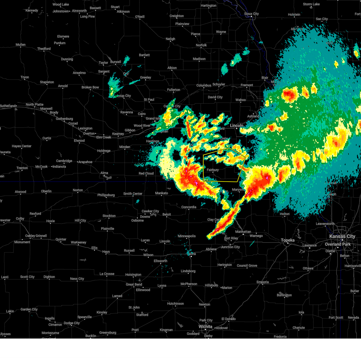 At 1003 pm cdt, severe thunderstorms were located along a line extending from 3 miles northwest of goehner to 5 miles southeast of mahaska, moving east at 40 mph (automated weather station. a few stations have reported wind speeds of 55 to 60 mph). Hazards include 60 mph wind gusts and nickel size hail. expect damage to roofs, siding, and trees At 1003 pm cdt, severe thunderstorms were located along a line extending from 3 miles northwest of goehner to 5 miles southeast of mahaska, moving east at 40 mph (automated weather station. a few stations have reported wind speeds of 55 to 60 mph). Hazards include 60 mph wind gusts and nickel size hail. expect damage to roofs, siding, and trees
|
| 5/7/2023 7:42 PM CDT |
 At 742 pm cdt, a severe thunderstorm was located over swanton, or 16 miles north of fairbury, moving northeast at 35 mph (radar indicated). Hazards include quarter size hail. People and animals outdoors will be injured. expect hail damage to roofs, siding, windows, and vehicles. expect wind damage to roofs, siding, and trees. locations impacted include, de witt, wilber and clatonia. hail threat, radar indicated max hail size, 1. 50 in wind threat, radar indicated max wind gust, 60 mph. At 742 pm cdt, a severe thunderstorm was located over swanton, or 16 miles north of fairbury, moving northeast at 35 mph (radar indicated). Hazards include quarter size hail. People and animals outdoors will be injured. expect hail damage to roofs, siding, windows, and vehicles. expect wind damage to roofs, siding, and trees. locations impacted include, de witt, wilber and clatonia. hail threat, radar indicated max hail size, 1. 50 in wind threat, radar indicated max wind gust, 60 mph.
|
| 5/7/2023 7:27 PM CDT |
 At 727 pm cdt, a severe thunderstorm was located 6 miles southeast of daykin, or 9 miles north of fairbury, moving northeast at 30 mph (radar indicated). Hazards include ping pong ball size hail and 60 mph wind gusts. People and animals outdoors will be injured. expect hail damage to roofs, siding, windows, and vehicles. expect wind damage to roofs, siding, and trees. this severe thunderstorm will be near, plymouth and swanton around 745 pm cdt. other locations in the path of this severe thunderstorm include de witt, wilber and clatonia. hail threat, radar indicated max hail size, 1. 50 in wind threat, radar indicated max wind gust, 60 mph. At 727 pm cdt, a severe thunderstorm was located 6 miles southeast of daykin, or 9 miles north of fairbury, moving northeast at 30 mph (radar indicated). Hazards include ping pong ball size hail and 60 mph wind gusts. People and animals outdoors will be injured. expect hail damage to roofs, siding, windows, and vehicles. expect wind damage to roofs, siding, and trees. this severe thunderstorm will be near, plymouth and swanton around 745 pm cdt. other locations in the path of this severe thunderstorm include de witt, wilber and clatonia. hail threat, radar indicated max hail size, 1. 50 in wind threat, radar indicated max wind gust, 60 mph.
|
| 5/7/2023 7:18 PM CDT |
 At 718 pm cdt, a severe thunderstorm was located 3 miles southeast of alexandria, or 10 miles northwest of fairbury, moving northeast at 20 mph (radar indicated). Hazards include 60 mph wind gusts and quarter size hail. Hail damage to vehicles is expected. expect wind damage to roofs, siding, and trees. locations impacted include, western, daykin, jansen, swan creek wildlife management area and alexandria state recreation area. hail threat, radar indicated max hail size, 1. 00 in wind threat, radar indicated max wind gust, 60 mph. At 718 pm cdt, a severe thunderstorm was located 3 miles southeast of alexandria, or 10 miles northwest of fairbury, moving northeast at 20 mph (radar indicated). Hazards include 60 mph wind gusts and quarter size hail. Hail damage to vehicles is expected. expect wind damage to roofs, siding, and trees. locations impacted include, western, daykin, jansen, swan creek wildlife management area and alexandria state recreation area. hail threat, radar indicated max hail size, 1. 00 in wind threat, radar indicated max wind gust, 60 mph.
|
| 5/7/2023 7:04 PM CDT |
 At 703 pm cdt, a severe thunderstorm was located over gilead, or 13 miles west of fairbury, moving northeast at 20 mph (radar indicated). Hazards include 60 mph wind gusts and quarter size hail. Hail damage to vehicles is expected. expect wind damage to roofs, siding, and trees. locations impacted include, fairbury, western, daykin, jansen, swan creek wildlife management area, alexandria state recreation area, cub creek recreational area and gladstone. hail threat, radar indicated max hail size, 1. 00 in wind threat, radar indicated max wind gust, 60 mph. At 703 pm cdt, a severe thunderstorm was located over gilead, or 13 miles west of fairbury, moving northeast at 20 mph (radar indicated). Hazards include 60 mph wind gusts and quarter size hail. Hail damage to vehicles is expected. expect wind damage to roofs, siding, and trees. locations impacted include, fairbury, western, daykin, jansen, swan creek wildlife management area, alexandria state recreation area, cub creek recreational area and gladstone. hail threat, radar indicated max hail size, 1. 00 in wind threat, radar indicated max wind gust, 60 mph.
|
| 5/7/2023 6:46 PM CDT |
 At 645 pm cdt, a severe thunderstorm was located 4 miles southeast of hebron, or 18 miles west of fairbury, moving northeast at 30 mph (radar indicated). Hazards include 60 mph wind gusts and quarter size hail. Hail damage to vehicles is expected. Expect wind damage to roofs, siding, and trees. At 645 pm cdt, a severe thunderstorm was located 4 miles southeast of hebron, or 18 miles west of fairbury, moving northeast at 30 mph (radar indicated). Hazards include 60 mph wind gusts and quarter size hail. Hail damage to vehicles is expected. Expect wind damage to roofs, siding, and trees.
|
| 5/6/2023 9:37 PM CDT |
 At 937 pm cdt, a severe thunderstorm was located near plymouth, or 13 miles west of beatrice, moving east at 60 mph (radar indicated). Hazards include 60 mph wind gusts and quarter size hail. Hail damage to vehicles is expected. expect wind damage to roofs, siding, and trees. locations impacted include, de witt. hail threat, radar indicated max hail size, 1. 00 in wind threat, radar indicated max wind gust, 60 mph. At 937 pm cdt, a severe thunderstorm was located near plymouth, or 13 miles west of beatrice, moving east at 60 mph (radar indicated). Hazards include 60 mph wind gusts and quarter size hail. Hail damage to vehicles is expected. expect wind damage to roofs, siding, and trees. locations impacted include, de witt. hail threat, radar indicated max hail size, 1. 00 in wind threat, radar indicated max wind gust, 60 mph.
|
| 5/6/2023 9:19 PM CDT |
 At 919 pm cdt, a severe thunderstorm was located over daykin, or 15 miles northwest of fairbury, moving east at 60 mph (radar indicated). Hazards include ping pong ball size hail, 60 mph wind gusts, and blowing dust. People and animals outdoors will be injured. expect hail damage to roofs, siding, windows, and vehicles. expect wind damage to roofs, siding, and trees. this severe thunderstorm will be near, western around 925 pm cdt. swanton around 930 pm cdt. plymouth around 935 pm cdt. other locations in the path of this severe thunderstorm include de witt. hail threat, radar indicated max hail size, 1. 50 in wind threat, radar indicated max wind gust, 60 mph. At 919 pm cdt, a severe thunderstorm was located over daykin, or 15 miles northwest of fairbury, moving east at 60 mph (radar indicated). Hazards include ping pong ball size hail, 60 mph wind gusts, and blowing dust. People and animals outdoors will be injured. expect hail damage to roofs, siding, windows, and vehicles. expect wind damage to roofs, siding, and trees. this severe thunderstorm will be near, western around 925 pm cdt. swanton around 930 pm cdt. plymouth around 935 pm cdt. other locations in the path of this severe thunderstorm include de witt. hail threat, radar indicated max hail size, 1. 50 in wind threat, radar indicated max wind gust, 60 mph.
|
| 10/11/2022 11:03 PM CDT |
 At 1103 pm cdt, severe thunderstorms were located along a line extending from 2 miles west of hallam to 4 miles southwest of endicott, moving east at 40 mph (trained weather spotters). Hazards include 70 mph wind gusts. Expect considerable tree damage. damage is likely to mobile homes, roofs, and outbuildings. locations impacted include, clatonia, hallam, sprague, cortland, hickman, diller, firth, adams, odell, panama, wymore, blue springs and barneston. thunderstorm damage threat, considerable hail threat, radar indicated max hail size, <. 75 in wind threat, radar indicated max wind gust, 70 mph. At 1103 pm cdt, severe thunderstorms were located along a line extending from 2 miles west of hallam to 4 miles southwest of endicott, moving east at 40 mph (trained weather spotters). Hazards include 70 mph wind gusts. Expect considerable tree damage. damage is likely to mobile homes, roofs, and outbuildings. locations impacted include, clatonia, hallam, sprague, cortland, hickman, diller, firth, adams, odell, panama, wymore, blue springs and barneston. thunderstorm damage threat, considerable hail threat, radar indicated max hail size, <. 75 in wind threat, radar indicated max wind gust, 70 mph.
|
| 10/11/2022 10:48 PM CDT |
 At 1048 pm cdt, severe thunderstorms were located along a line extending from 3 miles north of wilber to 3 miles southeast of reynolds, moving east at 40 mph (radar indicated). Hazards include 70 mph wind gusts. Expect considerable tree damage. damage is likely to mobile homes, roofs, and outbuildings. severe thunderstorms will be near, crete and wilber around 1055 pm cdt. clatonia around 1100 pm cdt. hallam around 1105 pm cdt. other locations in the path of these severe thunderstorms include cortland, sprague, steele city, hickman, firth, diller, panama, adams and odell. thunderstorm damage threat, considerable hail threat, radar indicated max hail size, <. 75 in wind threat, radar indicated max wind gust, 70 mph. At 1048 pm cdt, severe thunderstorms were located along a line extending from 3 miles north of wilber to 3 miles southeast of reynolds, moving east at 40 mph (radar indicated). Hazards include 70 mph wind gusts. Expect considerable tree damage. damage is likely to mobile homes, roofs, and outbuildings. severe thunderstorms will be near, crete and wilber around 1055 pm cdt. clatonia around 1100 pm cdt. hallam around 1105 pm cdt. other locations in the path of these severe thunderstorms include cortland, sprague, steele city, hickman, firth, diller, panama, adams and odell. thunderstorm damage threat, considerable hail threat, radar indicated max hail size, <. 75 in wind threat, radar indicated max wind gust, 70 mph.
|
| 7/26/2022 8:39 PM CDT |
 The severe thunderstorm warning for northwestern jefferson and saline counties will expire at 845 pm cdt, the storm which prompted the warning has weakened below severe limits, and no longer poses an immediate threat to life or property. therefore, the warning will be allowed to expire. however gusty winds are still possible with this thunderstorm. to report severe weather, contact your nearest law enforcement agency. they will relay your report to the national weather service omaha. The severe thunderstorm warning for northwestern jefferson and saline counties will expire at 845 pm cdt, the storm which prompted the warning has weakened below severe limits, and no longer poses an immediate threat to life or property. therefore, the warning will be allowed to expire. however gusty winds are still possible with this thunderstorm. to report severe weather, contact your nearest law enforcement agency. they will relay your report to the national weather service omaha.
|
| 7/26/2022 8:23 PM CDT |
 At 823 pm cdt, a severe thunderstorm was located 3 miles north of western, or 21 miles north of fairbury, moving southeast at 40 mph (radar indicated). Hazards include 60 mph wind gusts and quarter size hail. Hail damage to vehicles is expected. expect wind damage to roofs, siding, and trees. locations impacted include, swanton and de witt. hail threat, radar indicated max hail size, 1. 00 in wind threat, radar indicated max wind gust, 60 mph. At 823 pm cdt, a severe thunderstorm was located 3 miles north of western, or 21 miles north of fairbury, moving southeast at 40 mph (radar indicated). Hazards include 60 mph wind gusts and quarter size hail. Hail damage to vehicles is expected. expect wind damage to roofs, siding, and trees. locations impacted include, swanton and de witt. hail threat, radar indicated max hail size, 1. 00 in wind threat, radar indicated max wind gust, 60 mph.
|
| 7/26/2022 8:03 PM CDT |
 At 803 pm cdt, a severe thunderstorm was located 4 miles south of exeter, or 21 miles southeast of york, moving southeast at 35 mph (radar indicated). Hazards include 60 mph wind gusts and quarter size hail. Hail damage to vehicles is expected. expect wind damage to roofs, siding, and trees. this severe thunderstorm will be near, friend around 810 pm cdt. other locations in the path of this severe thunderstorm include western, swanton, wilber and de witt. hail threat, radar indicated max hail size, 1. 00 in wind threat, radar indicated max wind gust, 60 mph. At 803 pm cdt, a severe thunderstorm was located 4 miles south of exeter, or 21 miles southeast of york, moving southeast at 35 mph (radar indicated). Hazards include 60 mph wind gusts and quarter size hail. Hail damage to vehicles is expected. expect wind damage to roofs, siding, and trees. this severe thunderstorm will be near, friend around 810 pm cdt. other locations in the path of this severe thunderstorm include western, swanton, wilber and de witt. hail threat, radar indicated max hail size, 1. 00 in wind threat, radar indicated max wind gust, 60 mph.
|
| 6/12/2022 7:10 AM CDT |
 At 710 am cdt, a severe thunderstorm was located near belvidere, or 19 miles northwest of fairbury, moving east at 40 mph (radar indicated). Hazards include 60 mph wind gusts and quarter size hail. Hail damage to vehicles is expected. expect wind damage to roofs, siding, and trees. this severe thunderstorm will be near, daykin around 720 am cdt. other locations in the path of this severe thunderstorm include fairbury, endicott, jansen, steele city, harbine, diller and odell. hail threat, radar indicated max hail size, 1. 00 in wind threat, radar indicated max wind gust, 60 mph. At 710 am cdt, a severe thunderstorm was located near belvidere, or 19 miles northwest of fairbury, moving east at 40 mph (radar indicated). Hazards include 60 mph wind gusts and quarter size hail. Hail damage to vehicles is expected. expect wind damage to roofs, siding, and trees. this severe thunderstorm will be near, daykin around 720 am cdt. other locations in the path of this severe thunderstorm include fairbury, endicott, jansen, steele city, harbine, diller and odell. hail threat, radar indicated max hail size, 1. 00 in wind threat, radar indicated max wind gust, 60 mph.
|
| 6/11/2022 4:54 PM CDT |
 At 453 pm cdt, a severe thunderstorm capable of producing a tornado was located 8 miles south of dorchester, or 26 miles north of fairbury, moving southeast at 35 mph (radar indicated rotation). Hazards include tornado and two inch hail. Flying debris will be dangerous to those caught without shelter. mobile homes will be damaged or destroyed. damage to roofs, windows, and vehicles will occur. tree damage is likely. Locations impacted include, wilber, western, swanton, the highway 41 and 15 south junction and swan creek wildlife management area. At 453 pm cdt, a severe thunderstorm capable of producing a tornado was located 8 miles south of dorchester, or 26 miles north of fairbury, moving southeast at 35 mph (radar indicated rotation). Hazards include tornado and two inch hail. Flying debris will be dangerous to those caught without shelter. mobile homes will be damaged or destroyed. damage to roofs, windows, and vehicles will occur. tree damage is likely. Locations impacted include, wilber, western, swanton, the highway 41 and 15 south junction and swan creek wildlife management area.
|
| 6/11/2022 4:44 PM CDT |
 At 443 pm cdt, a severe thunderstorm capable of producing a tornado was located 5 miles southeast of friend, or 22 miles south of seward, moving southeast at 20 mph (radar indicated rotation). Hazards include tornado and tennis ball size hail. Flying debris will be dangerous to those caught without shelter. mobile homes will be damaged or destroyed. damage to roofs, windows, and vehicles will occur. Tree damage is likely. At 443 pm cdt, a severe thunderstorm capable of producing a tornado was located 5 miles southeast of friend, or 22 miles south of seward, moving southeast at 20 mph (radar indicated rotation). Hazards include tornado and tennis ball size hail. Flying debris will be dangerous to those caught without shelter. mobile homes will be damaged or destroyed. damage to roofs, windows, and vehicles will occur. Tree damage is likely.
|
| 6/7/2022 9:36 PM CDT |
 At 936 pm cdt, a severe thunderstorm was located 6 miles west of wilber, or 23 miles northwest of beatrice, moving southeast at 35 mph (radar indicated). Hazards include ping pong ball size hail and 60 mph wind gusts. People and animals outdoors will be injured. expect hail damage to roofs, siding, windows, and vehicles. expect wind damage to roofs, siding, and trees. this severe thunderstorm will be near, wilber and swanton around 945 pm cdt. de witt, plymouth and clatonia around 955 pm cdt. other locations in the path of this severe thunderstorm include beatrice and pickrell. hail threat, radar indicated max hail size, 1. 50 in wind threat, radar indicated max wind gust, 60 mph. At 936 pm cdt, a severe thunderstorm was located 6 miles west of wilber, or 23 miles northwest of beatrice, moving southeast at 35 mph (radar indicated). Hazards include ping pong ball size hail and 60 mph wind gusts. People and animals outdoors will be injured. expect hail damage to roofs, siding, windows, and vehicles. expect wind damage to roofs, siding, and trees. this severe thunderstorm will be near, wilber and swanton around 945 pm cdt. de witt, plymouth and clatonia around 955 pm cdt. other locations in the path of this severe thunderstorm include beatrice and pickrell. hail threat, radar indicated max hail size, 1. 50 in wind threat, radar indicated max wind gust, 60 mph.
|
| 6/7/2022 9:24 PM CDT |
 At 924 pm cdt, a severe thunderstorm was located 7 miles southwest of dorchester, or 25 miles south of seward, moving southeast at 35 mph (radar indicated). Hazards include two inch hail and 60 mph wind gusts. People and animals outdoors will be injured. expect hail damage to roofs, siding, windows, and vehicles. expect wind damage to roofs, siding, and trees. locations impacted include, crete, wilber, friend, dorchester, western, tobias, swanton, swan creek reservoir number 2, the highway 41 and 15 south junction, swan creek wildlife management area, blue river state recreation area, walnut creek recreation area and willard meyer recreation area. thunderstorm damage threat, considerable hail threat, radar indicated max hail size, 2. 00 in wind threat, radar indicated max wind gust, 60 mph. At 924 pm cdt, a severe thunderstorm was located 7 miles southwest of dorchester, or 25 miles south of seward, moving southeast at 35 mph (radar indicated). Hazards include two inch hail and 60 mph wind gusts. People and animals outdoors will be injured. expect hail damage to roofs, siding, windows, and vehicles. expect wind damage to roofs, siding, and trees. locations impacted include, crete, wilber, friend, dorchester, western, tobias, swanton, swan creek reservoir number 2, the highway 41 and 15 south junction, swan creek wildlife management area, blue river state recreation area, walnut creek recreation area and willard meyer recreation area. thunderstorm damage threat, considerable hail threat, radar indicated max hail size, 2. 00 in wind threat, radar indicated max wind gust, 60 mph.
|
| 6/7/2022 9:23 PM CDT | Measured by personal weather statio in saline county NE, 5 miles SSW of Western, NE |
| 6/7/2022 9:13 PM CDT |
 At 912 pm cdt, a severe thunderstorm was located 3 miles southeast of friend, or 21 miles south of seward, moving southeast at 45 mph (radar indicated). Hazards include two inch hail and 60 mph wind gusts. People and animals outdoors will be injured. expect hail damage to roofs, siding, windows, and vehicles. expect wind damage to roofs, siding, and trees. locations impacted include, crete, wilber, friend, dorchester, beaver crossing, western, cordova, tobias, swanton, swan creek reservoir number 2, the highway 41 and 15 south junction, swan creek wildlife management area, blue river state recreation area, walnut creek recreation area and willard meyer recreation area. thunderstorm damage threat, considerable hail threat, radar indicated max hail size, 2. 00 in wind threat, radar indicated max wind gust, 60 mph. At 912 pm cdt, a severe thunderstorm was located 3 miles southeast of friend, or 21 miles south of seward, moving southeast at 45 mph (radar indicated). Hazards include two inch hail and 60 mph wind gusts. People and animals outdoors will be injured. expect hail damage to roofs, siding, windows, and vehicles. expect wind damage to roofs, siding, and trees. locations impacted include, crete, wilber, friend, dorchester, beaver crossing, western, cordova, tobias, swanton, swan creek reservoir number 2, the highway 41 and 15 south junction, swan creek wildlife management area, blue river state recreation area, walnut creek recreation area and willard meyer recreation area. thunderstorm damage threat, considerable hail threat, radar indicated max hail size, 2. 00 in wind threat, radar indicated max wind gust, 60 mph.
|
| 6/7/2022 9:02 PM CDT |
 At 902 pm cdt, a severe thunderstorm was located near cordova, or 18 miles southwest of seward, moving southeast at 35 mph (radar indicated). Hazards include ping pong ball size hail and 60 mph wind gusts. People and animals outdoors will be injured. expect hail damage to roofs, siding, windows, and vehicles. expect wind damage to roofs, siding, and trees. locations impacted include, dorchester, crete and wilber. hail threat, radar indicated max hail size, 1. 50 in wind threat, radar indicated max wind gust, 60 mph. At 902 pm cdt, a severe thunderstorm was located near cordova, or 18 miles southwest of seward, moving southeast at 35 mph (radar indicated). Hazards include ping pong ball size hail and 60 mph wind gusts. People and animals outdoors will be injured. expect hail damage to roofs, siding, windows, and vehicles. expect wind damage to roofs, siding, and trees. locations impacted include, dorchester, crete and wilber. hail threat, radar indicated max hail size, 1. 50 in wind threat, radar indicated max wind gust, 60 mph.
|
| 6/7/2022 8:44 PM CDT |
 At 843 pm cdt, a severe thunderstorm was located 4 miles east of mccool junction, or 8 miles southeast of york, moving southeast at 35 mph (radar indicated). Hazards include ping pong ball size hail and 60 mph wind gusts. People and animals outdoors will be injured. expect hail damage to roofs, siding, windows, and vehicles. expect wind damage to roofs, siding, and trees. this severe thunderstorm will be near, beaver crossing and cordova around 900 pm cdt. other locations in the path of this severe thunderstorm include friend, dorchester, crete and wilber. this includes interstate 80 in nebraska between mile markers 366 and 377. hail threat, radar indicated max hail size, 1. 50 in wind threat, radar indicated max wind gust, 60 mph. At 843 pm cdt, a severe thunderstorm was located 4 miles east of mccool junction, or 8 miles southeast of york, moving southeast at 35 mph (radar indicated). Hazards include ping pong ball size hail and 60 mph wind gusts. People and animals outdoors will be injured. expect hail damage to roofs, siding, windows, and vehicles. expect wind damage to roofs, siding, and trees. this severe thunderstorm will be near, beaver crossing and cordova around 900 pm cdt. other locations in the path of this severe thunderstorm include friend, dorchester, crete and wilber. this includes interstate 80 in nebraska between mile markers 366 and 377. hail threat, radar indicated max hail size, 1. 50 in wind threat, radar indicated max wind gust, 60 mph.
|
| 4/29/2022 7:31 PM CDT |
 At 730 pm cdt, severe thunderstorms were located along a line extending from 5 miles southeast of duncan to 4 miles west of milligan, moving east at 45 mph (radar indicated). Hazards include 60 mph wind gusts and nickel size hail. Expect damage to roofs, siding, and trees. severe thunderstorms will be near, bellwood around 745 pm cdt. david city and western around 750 pm cdt. other locations in the path of these severe thunderstorms include wilber and de witt. this includes interstate 80 in nebraska between mile markers 366 and 388. hail threat, radar indicated max hail size, 0. 88 in wind threat, radar indicated max wind gust, 60 mph. At 730 pm cdt, severe thunderstorms were located along a line extending from 5 miles southeast of duncan to 4 miles west of milligan, moving east at 45 mph (radar indicated). Hazards include 60 mph wind gusts and nickel size hail. Expect damage to roofs, siding, and trees. severe thunderstorms will be near, bellwood around 745 pm cdt. david city and western around 750 pm cdt. other locations in the path of these severe thunderstorms include wilber and de witt. this includes interstate 80 in nebraska between mile markers 366 and 388. hail threat, radar indicated max hail size, 0. 88 in wind threat, radar indicated max wind gust, 60 mph.
|
| 4/29/2022 7:31 PM CDT |
 At 751 pm cdt, severe thunderstorms were located along a line extending from near bellwood to near friend, moving east at 40 mph (radar indicated). Hazards include 60 mph wind gusts and nickel size hail. Expect damage to roofs, siding, and trees. locations impacted include, david city, bellwood, milford and pleasant dale. hail threat, radar indicated max hail size, 0. 88 in wind threat, radar indicated max wind gust, 60 mph. At 751 pm cdt, severe thunderstorms were located along a line extending from near bellwood to near friend, moving east at 40 mph (radar indicated). Hazards include 60 mph wind gusts and nickel size hail. Expect damage to roofs, siding, and trees. locations impacted include, david city, bellwood, milford and pleasant dale. hail threat, radar indicated max hail size, 0. 88 in wind threat, radar indicated max wind gust, 60 mph.
|
| 4/12/2022 7:18 PM CDT |
 At 718 pm cdt, severe thunderstorms were located along a line extending from 4 miles southwest of pleasant dale to 4 miles south of western, moving northeast at 45 mph (radar indicated). Hazards include 70 mph wind gusts and quarter size hail. Hail damage to vehicles is expected. expect considerable tree damage. wind damage is also likely to mobile homes, roofs, and outbuildings. locations impacted include, wilber, de witt, clatonia, cortland and hallam. thunderstorm damage threat, considerable hail threat, radar indicated max hail size, 1. 00 in wind threat, radar indicated max wind gust, 70 mph. At 718 pm cdt, severe thunderstorms were located along a line extending from 4 miles southwest of pleasant dale to 4 miles south of western, moving northeast at 45 mph (radar indicated). Hazards include 70 mph wind gusts and quarter size hail. Hail damage to vehicles is expected. expect considerable tree damage. wind damage is also likely to mobile homes, roofs, and outbuildings. locations impacted include, wilber, de witt, clatonia, cortland and hallam. thunderstorm damage threat, considerable hail threat, radar indicated max hail size, 1. 00 in wind threat, radar indicated max wind gust, 70 mph.
|
| 4/12/2022 7:00 PM CDT |
 At 659 pm cdt, severe thunderstorms were located along a line extending from near dorchester to 5 miles west of western, moving northeast at 45 mph (radar indicated). Hazards include 60 mph wind gusts and quarter size hail. Hail damage to vehicles is expected. expect wind damage to roofs, siding, and trees. severe thunderstorms will be near, dorchester around 705 pm cdt. other locations in the path of these severe thunderstorms include wilber, de witt, clatonia, crete, hallam, cortland and hickman. hail threat, radar indicated max hail size, 1. 00 in wind threat, radar indicated max wind gust, 60 mph. At 659 pm cdt, severe thunderstorms were located along a line extending from near dorchester to 5 miles west of western, moving northeast at 45 mph (radar indicated). Hazards include 60 mph wind gusts and quarter size hail. Hail damage to vehicles is expected. expect wind damage to roofs, siding, and trees. severe thunderstorms will be near, dorchester around 705 pm cdt. other locations in the path of these severe thunderstorms include wilber, de witt, clatonia, crete, hallam, cortland and hickman. hail threat, radar indicated max hail size, 1. 00 in wind threat, radar indicated max wind gust, 60 mph.
|
| 8/7/2021 9:24 PM CDT |
 At 923 pm cdt, severe thunderstorms were located along a line extending from alexandria to fairbury to 4 miles northeast of washington, moving northeast at 45 mph (emergency management reported trees down in fairbury along with winds measured up to 53 mph). Hazards include 60 mph wind gusts and nickel size hail. Expect damage to roofs, siding, and trees. locations impacted include, fairbury, plymouth, odell, diller, western, daykin, endicott, jansen, swanton, reynolds, steele city, harbine, alexandria state recreation area, rock creek station state historical park, cub creek recreational area, crystal springs campground, buckley creek recreational area and camp jefferson. hail threat, radar indicated max hail size, 0. 88 in wind threat, observed max wind gust, 60 mph. At 923 pm cdt, severe thunderstorms were located along a line extending from alexandria to fairbury to 4 miles northeast of washington, moving northeast at 45 mph (emergency management reported trees down in fairbury along with winds measured up to 53 mph). Hazards include 60 mph wind gusts and nickel size hail. Expect damage to roofs, siding, and trees. locations impacted include, fairbury, plymouth, odell, diller, western, daykin, endicott, jansen, swanton, reynolds, steele city, harbine, alexandria state recreation area, rock creek station state historical park, cub creek recreational area, crystal springs campground, buckley creek recreational area and camp jefferson. hail threat, radar indicated max hail size, 0. 88 in wind threat, observed max wind gust, 60 mph.
|
| 8/7/2021 9:09 PM CDT |
 At 909 pm cdt, a severe thunderstorm was located over mahaska, or 20 miles northwest of washington, moving northeast at 40 mph (radar indicated). Hazards include 60 mph wind gusts and nickel size hail. expect damage to roofs, siding, and trees At 909 pm cdt, a severe thunderstorm was located over mahaska, or 20 miles northwest of washington, moving northeast at 40 mph (radar indicated). Hazards include 60 mph wind gusts and nickel size hail. expect damage to roofs, siding, and trees
|
| 7/10/2021 12:08 AM CDT | Storm damage reported in saline county NE, 0.7 miles S of Western, NE |
| 7/10/2021 12:06 AM CDT |
 At 1206 am cdt, severe thunderstorms were located along a line extending from weston to 5 miles southeast of western, moving east at 45 mph (radar indicated). Hazards include 75 mph wind gusts and penny size hail. Expect considerable tree damage. damage is likely to mobile homes, roofs, and outbuildings. Locations impacted include, northwestern lincoln, seward, crete, milford, wilber, friend, dorchester, valparaiso, de witt, beaver crossing, brainard, weston, staplehurst, western, garland, pleasant dale, dwight, bee, ulysses and malcolm. At 1206 am cdt, severe thunderstorms were located along a line extending from weston to 5 miles southeast of western, moving east at 45 mph (radar indicated). Hazards include 75 mph wind gusts and penny size hail. Expect considerable tree damage. damage is likely to mobile homes, roofs, and outbuildings. Locations impacted include, northwestern lincoln, seward, crete, milford, wilber, friend, dorchester, valparaiso, de witt, beaver crossing, brainard, weston, staplehurst, western, garland, pleasant dale, dwight, bee, ulysses and malcolm.
|
| 7/9/2021 11:43 PM CDT |
 At 1143 pm cdt, severe thunderstorms were located along a line extending from near brainard to 4 miles south of ohiowa, moving east at 50 mph (radar indicated). Hazards include 75 mph wind gusts and penny size hail. Expect considerable tree damage. damage is likely to mobile homes, roofs, and outbuildings. Locations impacted include, brainard, valparaiso, weston and de witt. At 1143 pm cdt, severe thunderstorms were located along a line extending from near brainard to 4 miles south of ohiowa, moving east at 50 mph (radar indicated). Hazards include 75 mph wind gusts and penny size hail. Expect considerable tree damage. damage is likely to mobile homes, roofs, and outbuildings. Locations impacted include, brainard, valparaiso, weston and de witt.
|
| 7/9/2021 11:26 PM CDT |
 At 1125 pm cdt, severe thunderstorms were located along a line extending from 4 miles east of rising city to near grafton, moving east at 45 mph (radar indicated). Hazards include 75 mph wind gusts. Expect considerable tree damage. damage is likely to mobile homes, roofs, and outbuildings. severe thunderstorms will be near, rising city around 1130 pm cdt. brainard around 1140 pm cdt. other locations in the path of these severe thunderstorms include valparaiso, friend, weston, dorchester, crete and wilber. This includes interstate 80 in nebraska between mile markers 366 and 395. At 1125 pm cdt, severe thunderstorms were located along a line extending from 4 miles east of rising city to near grafton, moving east at 45 mph (radar indicated). Hazards include 75 mph wind gusts. Expect considerable tree damage. damage is likely to mobile homes, roofs, and outbuildings. severe thunderstorms will be near, rising city around 1130 pm cdt. brainard around 1140 pm cdt. other locations in the path of these severe thunderstorms include valparaiso, friend, weston, dorchester, crete and wilber. This includes interstate 80 in nebraska between mile markers 366 and 395.
|
| 6/24/2021 6:00 PM CDT |
 At 559 pm cdt, severe thunderstorms were located along a line extending from 4 miles south of beaver crossing to 8 miles southwest of dorchester to 4 miles southeast of western, moving east at 30 mph. the strongest winds are expected to impact near a line from milligan to crete (radar indicated). Hazards include 70 mph wind gusts. Expect considerable tree damage. damage is likely to mobile homes, roofs, and outbuildings. Locations impacted include, dorchester, de witt, wilber and crete. At 559 pm cdt, severe thunderstorms were located along a line extending from 4 miles south of beaver crossing to 8 miles southwest of dorchester to 4 miles southeast of western, moving east at 30 mph. the strongest winds are expected to impact near a line from milligan to crete (radar indicated). Hazards include 70 mph wind gusts. Expect considerable tree damage. damage is likely to mobile homes, roofs, and outbuildings. Locations impacted include, dorchester, de witt, wilber and crete.
|
| 6/24/2021 5:35 PM CDT |
 At 534 pm cdt, severe thunderstorms were located along a line extending from near mccool junction to near milligan to 6 miles southeast of ohiowa, moving east at 30 mph (radar indicated). Hazards include 60 mph wind gusts. Expect damage to roofs, siding, and trees. severe thunderstorms will be near, western around 550 pm cdt. other locations in the path of these severe thunderstorms include friend, beaver crossing, wilber, dorchester and de witt. This includes interstate 80 in nebraska between mile markers 366 and 375. At 534 pm cdt, severe thunderstorms were located along a line extending from near mccool junction to near milligan to 6 miles southeast of ohiowa, moving east at 30 mph (radar indicated). Hazards include 60 mph wind gusts. Expect damage to roofs, siding, and trees. severe thunderstorms will be near, western around 550 pm cdt. other locations in the path of these severe thunderstorms include friend, beaver crossing, wilber, dorchester and de witt. This includes interstate 80 in nebraska between mile markers 366 and 375.
|
| 6/24/2021 2:37 AM CDT |
 At 236 am cdt, severe thunderstorms were located along a line extending from near ashland to 4 miles southwest of dorchester, moving southeast at 55 mph (radar indicated). Hazards include 60 mph wind gusts. Expect damage to roofs, siding, and trees. these severe storms will be near, louisville around 240 am cdt. Other locations in the path of these severe thunderstorms include elmwood, murdock, wilber, weeping water and de witt. At 236 am cdt, severe thunderstorms were located along a line extending from near ashland to 4 miles southwest of dorchester, moving southeast at 55 mph (radar indicated). Hazards include 60 mph wind gusts. Expect damage to roofs, siding, and trees. these severe storms will be near, louisville around 240 am cdt. Other locations in the path of these severe thunderstorms include elmwood, murdock, wilber, weeping water and de witt.
|
| 6/24/2021 2:24 AM CDT |
 At 223 am cdt, severe thunderstorms were located along a line extending from 7 miles southeast of mead to 4 miles south of beaver crossing, moving southeast at 55 mph (radar indicated). Hazards include 60 mph wind gusts. Expect damage to roofs, siding, and trees. severe thunderstorms will be near, greenwood around 235 am cdt. louisville and murdock around 240 am cdt. other locations in the path of these severe thunderstorms include wilber, elmwood, weeping water and de witt. This includes interstate 80 in nebraska between mile markers 369 and 426. At 223 am cdt, severe thunderstorms were located along a line extending from 7 miles southeast of mead to 4 miles south of beaver crossing, moving southeast at 55 mph (radar indicated). Hazards include 60 mph wind gusts. Expect damage to roofs, siding, and trees. severe thunderstorms will be near, greenwood around 235 am cdt. louisville and murdock around 240 am cdt. other locations in the path of these severe thunderstorms include wilber, elmwood, weeping water and de witt. This includes interstate 80 in nebraska between mile markers 369 and 426.
|
| 6/22/2021 9:36 PM CDT |
 At 935 pm cdt, a severe thunderstorm was located 5 miles east of milligan, or 29 miles southeast of york, moving southeast at 25 mph (radar indicated). Hazards include ping pong ball size hail and 60 mph wind gusts. People and animals outdoors will be injured. expect hail damage to roofs, siding, windows, and vehicles. expect wind damage to roofs, siding, and trees. this severe storm will be near, western around 950 pm cdt. Other locations impacted by this severe thunderstorm include swan creek reservoir number 2, swanton, 11 miles west of wilber, tobias, willard meyer recreation area and swan creek wildlife management area. At 935 pm cdt, a severe thunderstorm was located 5 miles east of milligan, or 29 miles southeast of york, moving southeast at 25 mph (radar indicated). Hazards include ping pong ball size hail and 60 mph wind gusts. People and animals outdoors will be injured. expect hail damage to roofs, siding, windows, and vehicles. expect wind damage to roofs, siding, and trees. this severe storm will be near, western around 950 pm cdt. Other locations impacted by this severe thunderstorm include swan creek reservoir number 2, swanton, 11 miles west of wilber, tobias, willard meyer recreation area and swan creek wildlife management area.
|
| 6/22/2021 9:26 PM CDT |
 At 926 pm cdt, a severe thunderstorm was located near friend, or 24 miles southeast of york, moving southeast at 25 mph (radar indicated). Hazards include ping pong ball size hail and 60 mph wind gusts. People and animals outdoors will be injured. expect hail damage to roofs, siding, windows, and vehicles. expect wind damage to roofs, siding, and trees. this severe storm will be near, western around 950 pm cdt. Other locations impacted by this severe thunderstorm include swan creek reservoir number 2, swanton, 11 miles west of wilber, tobias, willard meyer recreation area and swan creek wildlife management area. At 926 pm cdt, a severe thunderstorm was located near friend, or 24 miles southeast of york, moving southeast at 25 mph (radar indicated). Hazards include ping pong ball size hail and 60 mph wind gusts. People and animals outdoors will be injured. expect hail damage to roofs, siding, windows, and vehicles. expect wind damage to roofs, siding, and trees. this severe storm will be near, western around 950 pm cdt. Other locations impacted by this severe thunderstorm include swan creek reservoir number 2, swanton, 11 miles west of wilber, tobias, willard meyer recreation area and swan creek wildlife management area.
|
| 6/22/2021 9:18 PM CDT |
 At 918 pm cdt, a severe thunderstorm was located over friend, or 20 miles southeast of york, moving southeast at 25 mph (radar indicated). Hazards include ping pong ball size hail and 60 mph wind gusts. People and animals outdoors will be injured. expect hail damage to roofs, siding, windows, and vehicles. expect wind damage to roofs, siding, and trees. this severe thunderstorm will be near, western around 950 pm cdt. Other locations impacted by this severe thunderstorm include swan creek reservoir number 2, swanton, 11 miles west of wilber, tobias, willard meyer recreation area and swan creek wildlife management area. At 918 pm cdt, a severe thunderstorm was located over friend, or 20 miles southeast of york, moving southeast at 25 mph (radar indicated). Hazards include ping pong ball size hail and 60 mph wind gusts. People and animals outdoors will be injured. expect hail damage to roofs, siding, windows, and vehicles. expect wind damage to roofs, siding, and trees. this severe thunderstorm will be near, western around 950 pm cdt. Other locations impacted by this severe thunderstorm include swan creek reservoir number 2, swanton, 11 miles west of wilber, tobias, willard meyer recreation area and swan creek wildlife management area.
|
| 6/20/2021 12:19 AM CDT |
 At 1219 am cdt, severe thunderstorms were located along a line extending from near mccool junction to western to 5 miles northeast of haddam, moving east at 45 mph (radar indicated). Hazards include 60 mph wind gusts and penny size hail. Expect damage to roofs, siding, and trees. Locations impacted include, western, beaver crossing, wilber, de witt, milford and pleasant dale. At 1219 am cdt, severe thunderstorms were located along a line extending from near mccool junction to western to 5 miles northeast of haddam, moving east at 45 mph (radar indicated). Hazards include 60 mph wind gusts and penny size hail. Expect damage to roofs, siding, and trees. Locations impacted include, western, beaver crossing, wilber, de witt, milford and pleasant dale.
|
| 6/20/2021 12:01 AM CDT |
 At 1200 am cdt, severe thunderstorms were located along a line extending from near lushton to 4 miles east of bruning to near munden, moving east at 45 mph (radar indicated). Hazards include 60 mph wind gusts and penny size hail. Expect damage to roofs, siding, and trees. severe thunderstorms will be near, western around 1220 am cdt. other locations in the path of these severe thunderstorms include friend, plymouth, beaver crossing, wilber, de witt and milford. This includes interstate 80 in nebraska between mile markers 366 and 388. At 1200 am cdt, severe thunderstorms were located along a line extending from near lushton to 4 miles east of bruning to near munden, moving east at 45 mph (radar indicated). Hazards include 60 mph wind gusts and penny size hail. Expect damage to roofs, siding, and trees. severe thunderstorms will be near, western around 1220 am cdt. other locations in the path of these severe thunderstorms include friend, plymouth, beaver crossing, wilber, de witt and milford. This includes interstate 80 in nebraska between mile markers 366 and 388.
|
| 6/18/2021 9:38 PM CDT |
 The severe thunderstorm warning for northeastern jefferson and southeastern saline counties will expire at 945 pm cdt, the storm which prompted the warning has weakened below severe limits, and no longer poses an immediate threat to life or property. therefore, the warning will be allowed to expire. however small hail and gusty winds are still possible with this thunderstorm through 10 pm. The severe thunderstorm warning for northeastern jefferson and southeastern saline counties will expire at 945 pm cdt, the storm which prompted the warning has weakened below severe limits, and no longer poses an immediate threat to life or property. therefore, the warning will be allowed to expire. however small hail and gusty winds are still possible with this thunderstorm through 10 pm.
|
| 6/18/2021 9:34 PM CDT |
 At 934 pm cdt, a severe thunderstorm was located 6 miles southeast of western, or 20 miles west of beatrice, moving east at 35 mph (radar indicated). Hazards include 60 mph wind gusts and penny size hail. Expect damage to roofs, siding, and trees. This severe thunderstorm will remain over mainly rural areas of northeastern jefferson and southeastern saline counties, including the following locations, cub creek recreational area and swanton. At 934 pm cdt, a severe thunderstorm was located 6 miles southeast of western, or 20 miles west of beatrice, moving east at 35 mph (radar indicated). Hazards include 60 mph wind gusts and penny size hail. Expect damage to roofs, siding, and trees. This severe thunderstorm will remain over mainly rural areas of northeastern jefferson and southeastern saline counties, including the following locations, cub creek recreational area and swanton.
|
| 6/18/2021 9:25 PM CDT |
 At 925 pm cdt, a severe thunderstorm was located southwest of western, or 24 miles west of beatrice, moving east at 35 mph (radar indicated). Hazards include 60 mph wind gusts and quarter size hail. Hail damage to vehicles is expected. expect wind damage to roofs, siding, and trees. This severe thunderstorm will remain over mainly rural areas of northern jefferson and southern saline counties, including the following locations, cub creek recreational area, swanton, daykin, willard meyer recreation area and swan creek wildlife management area. At 925 pm cdt, a severe thunderstorm was located southwest of western, or 24 miles west of beatrice, moving east at 35 mph (radar indicated). Hazards include 60 mph wind gusts and quarter size hail. Hail damage to vehicles is expected. expect wind damage to roofs, siding, and trees. This severe thunderstorm will remain over mainly rural areas of northern jefferson and southern saline counties, including the following locations, cub creek recreational area, swanton, daykin, willard meyer recreation area and swan creek wildlife management area.
|
| 6/18/2021 9:15 PM CDT |
 At 915 pm cdt, a severe thunderstorm was located near daykin, or 28 miles west of beatrice, moving east at 40 mph (radar indicated). Hazards include 60 mph wind gusts and quarter size hail. Hail damage to vehicles is expected. expect wind damage to roofs, siding, and trees. This severe storm will be near, western around 920 pm cdt. At 915 pm cdt, a severe thunderstorm was located near daykin, or 28 miles west of beatrice, moving east at 40 mph (radar indicated). Hazards include 60 mph wind gusts and quarter size hail. Hail damage to vehicles is expected. expect wind damage to roofs, siding, and trees. This severe storm will be near, western around 920 pm cdt.
|
| 6/18/2021 9:07 PM CDT |
 At 907 pm cdt, a severe thunderstorm was located 6 miles west of western, or 30 miles west of beatrice, moving east at 45 mph (radar indicated). Hazards include 60 mph wind gusts and quarter size hail. Hail damage to vehicles is expected. expect wind damage to roofs, siding, and trees. This severe thunderstorm will be near, western around 915 pm cdt. At 907 pm cdt, a severe thunderstorm was located 6 miles west of western, or 30 miles west of beatrice, moving east at 45 mph (radar indicated). Hazards include 60 mph wind gusts and quarter size hail. Hail damage to vehicles is expected. expect wind damage to roofs, siding, and trees. This severe thunderstorm will be near, western around 915 pm cdt.
|
| 10/11/2020 9:57 PM CDT |
 A severe thunderstorm warning remains in effect until 1015 pm cdt for southern lancaster. jefferson. saline and western gage counties. At 957 pm cdt, severe thunderstorms were located along a line extending from 6 miles north of hickman to 6 miles south of fairbury, moving east at 50 mph. A severe thunderstorm warning remains in effect until 1015 pm cdt for southern lancaster. jefferson. saline and western gage counties. At 957 pm cdt, severe thunderstorms were located along a line extending from 6 miles north of hickman to 6 miles south of fairbury, moving east at 50 mph.
|
| 10/11/2020 9:57 PM CDT |
 At 957 pm cdt, severe thunderstorms were located along a line extending from 6 miles north of hickman to 6 miles south of fairbury, moving east at 50 mph (radar indicated). Hazards include 65 mph wind gusts. Expect damage to roofs, siding, and trees. Locations impacted include, beatrice, crete, fairbury, wilber, hickman, friend, bennet, firth, dorchester, de witt, cortland, plymouth, diller, panama, western, clatonia, hallam, pickrell, roca and daykin. At 957 pm cdt, severe thunderstorms were located along a line extending from 6 miles north of hickman to 6 miles south of fairbury, moving east at 50 mph (radar indicated). Hazards include 65 mph wind gusts. Expect damage to roofs, siding, and trees. Locations impacted include, beatrice, crete, fairbury, wilber, hickman, friend, bennet, firth, dorchester, de witt, cortland, plymouth, diller, panama, western, clatonia, hallam, pickrell, roca and daykin.
|
| 10/11/2020 9:38 PM CDT |
 At 938 pm cdt, severe thunderstorms were located along a line extending from 4 miles north of crete to hubbell, moving east at 50 mph (radar indicated). Hazards include 65 mph wind gusts. expect damage to roofs, siding, and trees At 938 pm cdt, severe thunderstorms were located along a line extending from 4 miles north of crete to hubbell, moving east at 50 mph (radar indicated). Hazards include 65 mph wind gusts. expect damage to roofs, siding, and trees
|
| 10/11/2020 9:15 PM CDT |
 At 915 pm cdt, severe thunderstorms were located along a line extending from near staplehurst to 4 miles north of milligan to near carleton, moving east at 45 mph (radar indicated). Hazards include 65 mph wind gusts. expect damage to roofs, siding, and trees At 915 pm cdt, severe thunderstorms were located along a line extending from near staplehurst to 4 miles north of milligan to near carleton, moving east at 45 mph (radar indicated). Hazards include 65 mph wind gusts. expect damage to roofs, siding, and trees
|
| 7/9/2020 1:06 AM CDT |
 At 105 am cdt, severe thunderstorms were located along a line extending from near cortland to 4 miles southwest of odell, moving east at 50 mph (radar indicated). Hazards include 75 mph wind gusts. Expect considerable tree damage. damage is likely to mobile homes, roofs, and outbuildings. Locations impacted include, beatrice, fairbury, wilber, wymore, de witt, cortland, plymouth, blue springs, odell, diller, western, clatonia, pickrell, adams, daykin, endicott, filley, jansen, barneston and swanton. At 105 am cdt, severe thunderstorms were located along a line extending from near cortland to 4 miles southwest of odell, moving east at 50 mph (radar indicated). Hazards include 75 mph wind gusts. Expect considerable tree damage. damage is likely to mobile homes, roofs, and outbuildings. Locations impacted include, beatrice, fairbury, wilber, wymore, de witt, cortland, plymouth, blue springs, odell, diller, western, clatonia, pickrell, adams, daykin, endicott, filley, jansen, barneston and swanton.
|
| 7/9/2020 1:01 AM CDT |
 At 1259 am cdt, severe thunderstorms were located along a line extending from hallam to near hollenberg, moving east at 50 mph. winds of 60 to 75 mph may occur for 15 to 20 minutes or possibly longer (radar indicated). Hazards include 75 mph wind gusts. Expect considerable tree damage. damage is likely to mobile homes, roofs, and outbuildings. Locations impacted include, beatrice, fairbury, wilber, wymore, de witt, cortland, plymouth, blue springs, odell, diller, western, clatonia, pickrell, adams, daykin, endicott, filley, jansen, barneston and swanton. At 1259 am cdt, severe thunderstorms were located along a line extending from hallam to near hollenberg, moving east at 50 mph. winds of 60 to 75 mph may occur for 15 to 20 minutes or possibly longer (radar indicated). Hazards include 75 mph wind gusts. Expect considerable tree damage. damage is likely to mobile homes, roofs, and outbuildings. Locations impacted include, beatrice, fairbury, wilber, wymore, de witt, cortland, plymouth, blue springs, odell, diller, western, clatonia, pickrell, adams, daykin, endicott, filley, jansen, barneston and swanton.
|
| 7/9/2020 12:55 AM CDT |
 The severe thunderstorm warning for seward, jefferson and saline counties will expire at 100 am cdt, the storms which prompted the warning continue to move eastward, and new warnings have been issued for parts of saline, jefferson and seward counties. a severe thunderstorm watch remains in effect until 500 am cdt for southeastern and east central nebraska. The severe thunderstorm warning for seward, jefferson and saline counties will expire at 100 am cdt, the storms which prompted the warning continue to move eastward, and new warnings have been issued for parts of saline, jefferson and seward counties. a severe thunderstorm watch remains in effect until 500 am cdt for southeastern and east central nebraska.
|
| 7/9/2020 12:53 AM CDT |
 At 1252 am cdt, severe thunderstorms were located along a line extending from 4 miles northeast of wilber to 5 miles northwest of hollenberg, moving east at 50 mph (radar indicated). Hazards include 75 mph wind gusts. Expect considerable tree damage. Damage is likely to mobile homes, roofs, and outbuildings. At 1252 am cdt, severe thunderstorms were located along a line extending from 4 miles northeast of wilber to 5 miles northwest of hollenberg, moving east at 50 mph (radar indicated). Hazards include 75 mph wind gusts. Expect considerable tree damage. Damage is likely to mobile homes, roofs, and outbuildings.
|
| 7/9/2020 12:44 AM CDT |
 At 1243 am cdt, severe thunderstorms were located along a line extending from near dwight to 6 miles northwest of wilber to 7 miles east of mahaska, moving east at 50 mph (radar indicated). Hazards include 75 mph wind gusts. Expect considerable tree damage. damage is likely to mobile homes, roofs, and outbuildings. locations impacted include, seward, crete, fairbury, milford, wilber, friend, utica, dorchester, de witt, plymouth, beaver crossing, diller, staplehurst, western, garland, pleasant dale, bee, daykin, goehner and cordova. This includes interstate 80 in nebraska between mile markers 366 and 388. At 1243 am cdt, severe thunderstorms were located along a line extending from near dwight to 6 miles northwest of wilber to 7 miles east of mahaska, moving east at 50 mph (radar indicated). Hazards include 75 mph wind gusts. Expect considerable tree damage. damage is likely to mobile homes, roofs, and outbuildings. locations impacted include, seward, crete, fairbury, milford, wilber, friend, utica, dorchester, de witt, plymouth, beaver crossing, diller, staplehurst, western, garland, pleasant dale, bee, daykin, goehner and cordova. This includes interstate 80 in nebraska between mile markers 366 and 388.
|
| 7/9/2020 12:37 AM CDT |
 At 1237 am cdt, severe thunderstorms were located along a line extending from near bee to near mahaska, moving east at 50 mph (radar indicated). Hazards include 70 mph wind gusts. Expect considerable tree damage. damage is likely to mobile homes, roofs, and outbuildings. locations impacted include, seward, crete, fairbury, milford, wilber, friend, utica, dorchester, de witt, plymouth, beaver crossing, diller, staplehurst, western, garland, pleasant dale, bee, daykin, goehner and cordova. This includes interstate 80 in nebraska between mile markers 366 and 388. At 1237 am cdt, severe thunderstorms were located along a line extending from near bee to near mahaska, moving east at 50 mph (radar indicated). Hazards include 70 mph wind gusts. Expect considerable tree damage. damage is likely to mobile homes, roofs, and outbuildings. locations impacted include, seward, crete, fairbury, milford, wilber, friend, utica, dorchester, de witt, plymouth, beaver crossing, diller, staplehurst, western, garland, pleasant dale, bee, daykin, goehner and cordova. This includes interstate 80 in nebraska between mile markers 366 and 388.
|
| 7/9/2020 12:26 AM CDT |
 At 1225 am cdt, severe thunderstorms were located along a line extending from near ulysses to hubbell, moving east at 50 mph (radar indicated). Hazards include 70 mph wind gusts. Expect considerable tree damage. damage is likely to mobile homes, roofs, and outbuildings. locations impacted include, seward, crete, fairbury, milford, wilber, friend, utica, dorchester, de witt, plymouth, beaver crossing, diller, staplehurst, western, garland, pleasant dale, bee, daykin, goehner and cordova. This includes interstate 80 in nebraska between mile markers 366 and 388. At 1225 am cdt, severe thunderstorms were located along a line extending from near ulysses to hubbell, moving east at 50 mph (radar indicated). Hazards include 70 mph wind gusts. Expect considerable tree damage. damage is likely to mobile homes, roofs, and outbuildings. locations impacted include, seward, crete, fairbury, milford, wilber, friend, utica, dorchester, de witt, plymouth, beaver crossing, diller, staplehurst, western, garland, pleasant dale, bee, daykin, goehner and cordova. This includes interstate 80 in nebraska between mile markers 366 and 388.
|
| 7/9/2020 12:17 AM CDT |
 At 1216 am cdt, severe thunderstorms were located along a line extending from gresham to chester, moving east at 50 mph. the strongest winds are currently expected across jefferson county but winds of 60 to 70 mph are expected for most of the warned area (radar indicated). Hazards include 70 mph wind gusts. Expect considerable tree damage. damage is likely to mobile homes, roofs, and outbuildings. locations impacted include, seward, crete, fairbury, milford, wilber, friend, utica, dorchester, de witt, plymouth, beaver crossing, diller, staplehurst, western, garland, pleasant dale, bee, daykin, goehner and cordova. This includes interstate 80 in nebraska between mile markers 366 and 388. At 1216 am cdt, severe thunderstorms were located along a line extending from gresham to chester, moving east at 50 mph. the strongest winds are currently expected across jefferson county but winds of 60 to 70 mph are expected for most of the warned area (radar indicated). Hazards include 70 mph wind gusts. Expect considerable tree damage. damage is likely to mobile homes, roofs, and outbuildings. locations impacted include, seward, crete, fairbury, milford, wilber, friend, utica, dorchester, de witt, plymouth, beaver crossing, diller, staplehurst, western, garland, pleasant dale, bee, daykin, goehner and cordova. This includes interstate 80 in nebraska between mile markers 366 and 388.
|
| 7/9/2020 12:07 AM CDT |
 At 1206 am cdt, severe thunderstorms were located along a line extending from near benedict to near byron, moving east at 50 mph (radar indicated). Hazards include 70 mph wind gusts. Expect considerable tree damage. Damage is likely to mobile homes, roofs, and outbuildings. At 1206 am cdt, severe thunderstorms were located along a line extending from near benedict to near byron, moving east at 50 mph (radar indicated). Hazards include 70 mph wind gusts. Expect considerable tree damage. Damage is likely to mobile homes, roofs, and outbuildings.
|
| 6/28/2020 3:07 AM CDT |
 The severe thunderstorm warning for jefferson, saline and western gage counties will expire at 315 am cdt, the storms which prompted the warning have moved out of the warned area. another warning is in effect for areas to the east. The severe thunderstorm warning for jefferson, saline and western gage counties will expire at 315 am cdt, the storms which prompted the warning have moved out of the warned area. another warning is in effect for areas to the east.
|
| 6/28/2020 3:00 AM CDT |
 At 259 am cdt, severe thunderstorms were located along a line extending from crete to near odell, moving east at 45 mph (radar indicated). Hazards include 70 mph wind gusts and quarter size hail. Hail damage to vehicles is expected. expect considerable tree damage. wind damage is also likely to mobile homes, roofs, and outbuildings. Locations impacted include, crete, fairbury, wilber, de witt, plymouth, diller, western, daykin, endicott, jansen, swanton, steele city, harbine, swan creek reservoir number 2, swan creek wildlife management area, rock creek station state historical park, cub creek recreational area, 11 miles west of wilber, crystal springs campground and camp jefferson. At 259 am cdt, severe thunderstorms were located along a line extending from crete to near odell, moving east at 45 mph (radar indicated). Hazards include 70 mph wind gusts and quarter size hail. Hail damage to vehicles is expected. expect considerable tree damage. wind damage is also likely to mobile homes, roofs, and outbuildings. Locations impacted include, crete, fairbury, wilber, de witt, plymouth, diller, western, daykin, endicott, jansen, swanton, steele city, harbine, swan creek reservoir number 2, swan creek wildlife management area, rock creek station state historical park, cub creek recreational area, 11 miles west of wilber, crystal springs campground and camp jefferson.
|
| 6/28/2020 2:53 AM CDT |
 At 252 am cdt, severe thunderstorms were located along a line extending from near crete to 4 miles southwest of odell, moving east at 50 mph. small circulations are developing along the leading edge of the line and a very brief tornado could occur (radar indicated). Hazards include 70 mph wind gusts and quarter size hail. Hail damage to vehicles is expected. expect considerable tree damage. wind damage is also likely to mobile homes, roofs, and outbuildings. Locations impacted include, crete, fairbury, wilber, friend, dorchester, de witt, plymouth, diller, western, daykin, endicott, jansen, tobias, swanton, reynolds, steele city, harbine, swan creek reservoir number 2, swan creek wildlife management area and alexandria state recreation area. At 252 am cdt, severe thunderstorms were located along a line extending from near crete to 4 miles southwest of odell, moving east at 50 mph. small circulations are developing along the leading edge of the line and a very brief tornado could occur (radar indicated). Hazards include 70 mph wind gusts and quarter size hail. Hail damage to vehicles is expected. expect considerable tree damage. wind damage is also likely to mobile homes, roofs, and outbuildings. Locations impacted include, crete, fairbury, wilber, friend, dorchester, de witt, plymouth, diller, western, daykin, endicott, jansen, tobias, swanton, reynolds, steele city, harbine, swan creek reservoir number 2, swan creek wildlife management area and alexandria state recreation area.
|
| 6/28/2020 2:49 AM CDT |
 At 248 am cdt, severe thunderstorms were located along a line extending from near dorchester to 4 miles northeast of hollenberg, moving east at 50 mph. these storms have produced measured winds of over 60 mph (radar indicated). Hazards include 65 mph wind gusts and quarter size hail. Hail damage to vehicles is expected. expect wind damage to roofs, siding, and trees. Locations impacted include, crete, fairbury, wilber, friend, dorchester, de witt, plymouth, diller, western, daykin, endicott, jansen, tobias, swanton, reynolds, steele city, harbine, swan creek reservoir number 2, swan creek wildlife management area and alexandria state recreation area. At 248 am cdt, severe thunderstorms were located along a line extending from near dorchester to 4 miles northeast of hollenberg, moving east at 50 mph. these storms have produced measured winds of over 60 mph (radar indicated). Hazards include 65 mph wind gusts and quarter size hail. Hail damage to vehicles is expected. expect wind damage to roofs, siding, and trees. Locations impacted include, crete, fairbury, wilber, friend, dorchester, de witt, plymouth, diller, western, daykin, endicott, jansen, tobias, swanton, reynolds, steele city, harbine, swan creek reservoir number 2, swan creek wildlife management area and alexandria state recreation area.
|
| 6/28/2020 2:40 AM CDT |
 At 239 am cdt, severe thunderstorms were located along a line extending from near friend to 5 miles west of hollenberg, moving east at 50 mph. the main threat for hail is in western saline county. the wind threat is for the whole warning area but especially southern saline and northern jefferson county (radar indicated). Hazards include 65 mph wind gusts and quarter size hail. Hail damage to vehicles is expected. expect wind damage to roofs, siding, and trees. Locations impacted include, crete, fairbury, wilber, friend, dorchester, de witt, plymouth, diller, western, daykin, endicott, jansen, tobias, swanton, reynolds, steele city, harbine, swan creek reservoir number 2, swan creek wildlife management area and alexandria state recreation area. At 239 am cdt, severe thunderstorms were located along a line extending from near friend to 5 miles west of hollenberg, moving east at 50 mph. the main threat for hail is in western saline county. the wind threat is for the whole warning area but especially southern saline and northern jefferson county (radar indicated). Hazards include 65 mph wind gusts and quarter size hail. Hail damage to vehicles is expected. expect wind damage to roofs, siding, and trees. Locations impacted include, crete, fairbury, wilber, friend, dorchester, de witt, plymouth, diller, western, daykin, endicott, jansen, tobias, swanton, reynolds, steele city, harbine, swan creek reservoir number 2, swan creek wildlife management area and alexandria state recreation area.
|
| 6/28/2020 2:34 AM CDT |
 At 234 am cdt, severe thunderstorms were located along a line extending from 5 miles south of friend to 5 miles north of morrowville, moving east at 45 mph. another storm ahead of the line was near wilber and could be producing one inch hail (radar indicated). Hazards include 65 mph wind gusts and half dollar size hail. Hail damage to vehicles is expected. expect wind damage to roofs, siding, and trees. Locations impacted include, crete, fairbury, wilber, friend, dorchester, de witt, plymouth, diller, western, daykin, endicott, jansen, tobias, swanton, reynolds, steele city, harbine, swan creek reservoir number 2, swan creek wildlife management area and alexandria state recreation area. At 234 am cdt, severe thunderstorms were located along a line extending from 5 miles south of friend to 5 miles north of morrowville, moving east at 45 mph. another storm ahead of the line was near wilber and could be producing one inch hail (radar indicated). Hazards include 65 mph wind gusts and half dollar size hail. Hail damage to vehicles is expected. expect wind damage to roofs, siding, and trees. Locations impacted include, crete, fairbury, wilber, friend, dorchester, de witt, plymouth, diller, western, daykin, endicott, jansen, tobias, swanton, reynolds, steele city, harbine, swan creek reservoir number 2, swan creek wildlife management area and alexandria state recreation area.
|
| 6/28/2020 2:26 AM CDT |
 At 225 am cdt, severe thunderstorms were located along a line extending from near milligan to 5 miles north of haddam, moving east at 40 mph (radar indicated). Hazards include 65 mph wind gusts and half dollar size hail. Hail damage to vehicles is expected. Expect wind damage to roofs, siding, and trees. At 225 am cdt, severe thunderstorms were located along a line extending from near milligan to 5 miles north of haddam, moving east at 40 mph (radar indicated). Hazards include 65 mph wind gusts and half dollar size hail. Hail damage to vehicles is expected. Expect wind damage to roofs, siding, and trees.
|
| 6/28/2020 2:12 AM CDT |
 At 211 am cdt, a severe thunderstorm was located 5 miles northeast of western, or 24 miles northwest of beatrice, moving northeast at 25 mph (radar indicated). Hazards include 60 mph wind gusts and nickel size hail. Expect damage to roofs, siding, and trees. Locations impacted include, crete, wilber, dorchester, western, swanton, swan creek reservoir number 2, swan creek wildlife management area, 11 miles west of wilber and willard meyer recreation area. At 211 am cdt, a severe thunderstorm was located 5 miles northeast of western, or 24 miles northwest of beatrice, moving northeast at 25 mph (radar indicated). Hazards include 60 mph wind gusts and nickel size hail. Expect damage to roofs, siding, and trees. Locations impacted include, crete, wilber, dorchester, western, swanton, swan creek reservoir number 2, swan creek wildlife management area, 11 miles west of wilber and willard meyer recreation area.
|
| 6/28/2020 2:02 AM CDT |
 At 202 am cdt, a severe thunderstorm was located near western, or 28 miles northwest of beatrice, moving northeast at 25 mph (radar indicated). Hazards include 60 mph wind gusts and nickel size hail. Expect damage to roofs, siding, and trees. Locations impacted include, crete, wilber, dorchester, western, daykin, tobias, swanton, swan creek reservoir number 2, swan creek wildlife management area, 11 miles west of wilber and willard meyer recreation area. At 202 am cdt, a severe thunderstorm was located near western, or 28 miles northwest of beatrice, moving northeast at 25 mph (radar indicated). Hazards include 60 mph wind gusts and nickel size hail. Expect damage to roofs, siding, and trees. Locations impacted include, crete, wilber, dorchester, western, daykin, tobias, swanton, swan creek reservoir number 2, swan creek wildlife management area, 11 miles west of wilber and willard meyer recreation area.
|
| 6/28/2020 1:55 AM CDT |
 At 154 am cdt, a severe thunderstorm was located near western, or 29 miles west of beatrice, moving northeast at 25 mph (radar indicated). Hazards include 60 mph wind gusts and quarter size hail. Hail damage to vehicles is expected. expect wind damage to roofs, siding, and trees. Locations impacted include, crete, wilber, dorchester, western, daykin, tobias, swanton, swan creek reservoir number 2, swan creek wildlife management area, 11 miles west of wilber and willard meyer recreation area. At 154 am cdt, a severe thunderstorm was located near western, or 29 miles west of beatrice, moving northeast at 25 mph (radar indicated). Hazards include 60 mph wind gusts and quarter size hail. Hail damage to vehicles is expected. expect wind damage to roofs, siding, and trees. Locations impacted include, crete, wilber, dorchester, western, daykin, tobias, swanton, swan creek reservoir number 2, swan creek wildlife management area, 11 miles west of wilber and willard meyer recreation area.
|
| 6/28/2020 1:43 AM CDT |
 At 143 am cdt, a severe thunderstorm was located 6 miles west of western, or 30 miles west of beatrice, moving northeast at 25 mph (radar indicated). Hazards include 60 mph wind gusts and quarter size hail. Hail damage to vehicles is expected. Expect wind damage to roofs, siding, and trees. At 143 am cdt, a severe thunderstorm was located 6 miles west of western, or 30 miles west of beatrice, moving northeast at 25 mph (radar indicated). Hazards include 60 mph wind gusts and quarter size hail. Hail damage to vehicles is expected. Expect wind damage to roofs, siding, and trees.
|
| 6/28/2020 1:22 AM CDT |
 The severe thunderstorm warning for jefferson, saline and west central gage counties will expire at 130 am cdt, the storms which prompted the warning have weakened below severe limits, and no longer pose an immediate threat to life or property. therefore, the warning will be allowed to expire. however gusty winds and heavy rain are still possible with these thunderstorms. other storms are possible the next hour or two. the strongest storms as of 120 am cdt were in thayer county, northwest of alexandria. The severe thunderstorm warning for jefferson, saline and west central gage counties will expire at 130 am cdt, the storms which prompted the warning have weakened below severe limits, and no longer pose an immediate threat to life or property. therefore, the warning will be allowed to expire. however gusty winds and heavy rain are still possible with these thunderstorms. other storms are possible the next hour or two. the strongest storms as of 120 am cdt were in thayer county, northwest of alexandria.
|
| 6/28/2020 1:11 AM CDT |
 At 110 am cdt, severe thunderstorms were located along a line extending from 7 miles east of alexandria to 6 miles southeast of fairbury, moving northeast at 35 mph. the storms had weakened a little since 1 am cdt (radar indicated). Hazards include 60 mph wind gusts and nickel size hail. Expect damage to roofs, siding, and trees. Locations impacted include, fairbury, wilber, de witt, plymouth, diller, western, daykin, endicott, jansen, tobias, swanton, reynolds, harbine, swan creek reservoir number 2, swan creek wildlife management area, alexandria state recreation area, rock creek station state historical park, cub creek recreational area, 11 miles west of wilber and crystal springs campground. At 110 am cdt, severe thunderstorms were located along a line extending from 7 miles east of alexandria to 6 miles southeast of fairbury, moving northeast at 35 mph. the storms had weakened a little since 1 am cdt (radar indicated). Hazards include 60 mph wind gusts and nickel size hail. Expect damage to roofs, siding, and trees. Locations impacted include, fairbury, wilber, de witt, plymouth, diller, western, daykin, endicott, jansen, tobias, swanton, reynolds, harbine, swan creek reservoir number 2, swan creek wildlife management area, alexandria state recreation area, rock creek station state historical park, cub creek recreational area, 11 miles west of wilber and crystal springs campground.
|
| 6/28/2020 1:02 AM CDT |
 At 102 am cdt, severe thunderstorms were located along a line extending from 5 miles east of alexandria to near fairbury, moving northeast at 20 mph (radar indicated). Hazards include 60 mph wind gusts and quarter size hail. Hail damage to vehicles is expected. expect wind damage to roofs, siding, and trees. Locations impacted include, fairbury, wilber, de witt, plymouth, diller, western, daykin, endicott, jansen, tobias, swanton, reynolds, harbine, swan creek reservoir number 2, swan creek wildlife management area, alexandria state recreation area, rock creek station state historical park, cub creek recreational area, 11 miles west of wilber and crystal springs campground. At 102 am cdt, severe thunderstorms were located along a line extending from 5 miles east of alexandria to near fairbury, moving northeast at 20 mph (radar indicated). Hazards include 60 mph wind gusts and quarter size hail. Hail damage to vehicles is expected. expect wind damage to roofs, siding, and trees. Locations impacted include, fairbury, wilber, de witt, plymouth, diller, western, daykin, endicott, jansen, tobias, swanton, reynolds, harbine, swan creek reservoir number 2, swan creek wildlife management area, alexandria state recreation area, rock creek station state historical park, cub creek recreational area, 11 miles west of wilber and crystal springs campground.
|
| 6/28/2020 12:52 AM CDT |
 At 1252 am cdt, severe thunderstorms were located along a line extending from 4 miles east of alexandria to 4 miles southwest of fairbury, moving northeast at 35 mph (radar indicated). Hazards include 60 mph wind gusts and quarter size hail. Hail damage to vehicles is expected. expect wind damage to roofs, siding, and trees. Locations impacted include, fairbury, wilber, de witt, plymouth, diller, western, daykin, endicott, jansen, tobias, swanton, reynolds, harbine, swan creek reservoir number 2, swan creek wildlife management area, alexandria state recreation area, rock creek station state historical park, cub creek recreational area, 11 miles west of wilber and crystal springs campground. At 1252 am cdt, severe thunderstorms were located along a line extending from 4 miles east of alexandria to 4 miles southwest of fairbury, moving northeast at 35 mph (radar indicated). Hazards include 60 mph wind gusts and quarter size hail. Hail damage to vehicles is expected. expect wind damage to roofs, siding, and trees. Locations impacted include, fairbury, wilber, de witt, plymouth, diller, western, daykin, endicott, jansen, tobias, swanton, reynolds, harbine, swan creek reservoir number 2, swan creek wildlife management area, alexandria state recreation area, rock creek station state historical park, cub creek recreational area, 11 miles west of wilber and crystal springs campground.
|
| 6/28/2020 12:42 AM CDT |
 At 1242 am cdt, a severe thunderstorm was located over gilead, or 27 miles northeast of belleville, moving northeast at 35 mph (radar indicated). Hazards include 60 mph wind gusts and quarter size hail. Hail damage to vehicles is expected. Expect wind damage to roofs, siding, and trees. At 1242 am cdt, a severe thunderstorm was located over gilead, or 27 miles northeast of belleville, moving northeast at 35 mph (radar indicated). Hazards include 60 mph wind gusts and quarter size hail. Hail damage to vehicles is expected. Expect wind damage to roofs, siding, and trees.
|
| 6/9/2020 6:10 PM CDT |
 At 610 pm cdt, a severe thunderstorm was located 6 miles southwest of western, or 26 miles west of beatrice, moving north at 55 mph (radar indicated). Hazards include 60 mph wind gusts and quarter size hail. Hail damage to vehicles is expected. Expect wind damage to roofs, siding, and trees. At 610 pm cdt, a severe thunderstorm was located 6 miles southwest of western, or 26 miles west of beatrice, moving north at 55 mph (radar indicated). Hazards include 60 mph wind gusts and quarter size hail. Hail damage to vehicles is expected. Expect wind damage to roofs, siding, and trees.
|
| 6/3/2020 11:27 PM CDT |
 The severe thunderstorm warning for southern lancaster, southeastern seward, jefferson, eastern saline and northwestern gage counties will expire at 1130 pm cdt, the storms which prompted the warning have moved out of the area. therefore, the warning will be allowed to expire. however gusty winds are still possible with these thunderstorms. a severe thunderstorm watch remains in effect until 300 am cdt for southeastern nebraska. The severe thunderstorm warning for southern lancaster, southeastern seward, jefferson, eastern saline and northwestern gage counties will expire at 1130 pm cdt, the storms which prompted the warning have moved out of the area. therefore, the warning will be allowed to expire. however gusty winds are still possible with these thunderstorms. a severe thunderstorm watch remains in effect until 300 am cdt for southeastern nebraska.
|
| 6/3/2020 10:56 PM CDT |
 At 1056 pm cdt, severe thunderstorms were located along a line extending from 7 miles east of crete to near de witt to 6 miles southwest of fairbury, moving southeast at 45 mph (radar indicated). Hazards include 65 mph wind gusts. Expect damage to roofs, siding, and trees. locations impacted include, southern lincoln, beatrice, crete, fairbury, wilber, hickman, firth, de witt, cortland, plymouth, diller, panama, western, clatonia, hallam, pleasant dale, pickrell, roca, denton and daykin. This includes interstate 80 in nebraska near mile marker 385. At 1056 pm cdt, severe thunderstorms were located along a line extending from 7 miles east of crete to near de witt to 6 miles southwest of fairbury, moving southeast at 45 mph (radar indicated). Hazards include 65 mph wind gusts. Expect damage to roofs, siding, and trees. locations impacted include, southern lincoln, beatrice, crete, fairbury, wilber, hickman, firth, de witt, cortland, plymouth, diller, panama, western, clatonia, hallam, pleasant dale, pickrell, roca, denton and daykin. This includes interstate 80 in nebraska near mile marker 385.
|
| 6/3/2020 10:40 PM CDT |
 At 1038 pm cdt, severe thunderstorms were located along a line extending from near pleasant dale to 4 miles west of wilber to near alexandria, moving southeast at 45 mph (radar indicated). Hazards include 65 mph wind gusts. expect damage to roofs, siding, and trees At 1038 pm cdt, severe thunderstorms were located along a line extending from near pleasant dale to 4 miles west of wilber to near alexandria, moving southeast at 45 mph (radar indicated). Hazards include 65 mph wind gusts. expect damage to roofs, siding, and trees
|
| 6/3/2020 10:30 PM CDT |
 At 1030 pm cdt, a severe thunderstorm was located 7 miles northwest of wilber, or 25 miles northwest of beatrice, moving southeast at 40 mph (trained weather spotters). Hazards include 65 mph wind gusts. Expect damage to roofs, siding, and trees. locations impacted include, southern lincoln, beatrice, crete, milford, wilber, hickman, friend, utica, bennet, firth, dorchester, de witt, cortland, plymouth, beaver crossing, western, clatonia, hallam, pleasant dale and pickrell. This includes interstate 80 in nebraska between mile markers 366 and 385. At 1030 pm cdt, a severe thunderstorm was located 7 miles northwest of wilber, or 25 miles northwest of beatrice, moving southeast at 40 mph (trained weather spotters). Hazards include 65 mph wind gusts. Expect damage to roofs, siding, and trees. locations impacted include, southern lincoln, beatrice, crete, milford, wilber, hickman, friend, utica, bennet, firth, dorchester, de witt, cortland, plymouth, beaver crossing, western, clatonia, hallam, pleasant dale and pickrell. This includes interstate 80 in nebraska between mile markers 366 and 385.
|
| 6/3/2020 10:13 PM CDT |
 At 1012 pm cdt, a severe thunderstorm was located near dorchester, or 28 miles southeast of york, moving southeast at 45 mph (radar indicated). Hazards include 70 mph wind gusts. Expect considerable tree damage. damage is likely to mobile homes, roofs, and outbuildings. locations impacted include, southern lincoln, beatrice, seward, crete, milford, wilber, hickman, friend, utica, bennet, firth, dorchester, de witt, cortland, plymouth, beaver crossing, staplehurst, western, clatonia and hallam. This includes interstate 80 in nebraska between mile markers 366 and 395. At 1012 pm cdt, a severe thunderstorm was located near dorchester, or 28 miles southeast of york, moving southeast at 45 mph (radar indicated). Hazards include 70 mph wind gusts. Expect considerable tree damage. damage is likely to mobile homes, roofs, and outbuildings. locations impacted include, southern lincoln, beatrice, seward, crete, milford, wilber, hickman, friend, utica, bennet, firth, dorchester, de witt, cortland, plymouth, beaver crossing, staplehurst, western, clatonia and hallam. This includes interstate 80 in nebraska between mile markers 366 and 395.
|
| 6/3/2020 9:55 PM CDT |
 At 955 pm cdt, a severe thunderstorm was located near mccool junction, or 11 miles south of york, moving southeast at 45 mph (radar indicated). Hazards include 70 mph wind gusts. Expect considerable tree damage. Damage is likely to mobile homes, roofs, and outbuildings. At 955 pm cdt, a severe thunderstorm was located near mccool junction, or 11 miles south of york, moving southeast at 45 mph (radar indicated). Hazards include 70 mph wind gusts. Expect considerable tree damage. Damage is likely to mobile homes, roofs, and outbuildings.
|
| 9/21/2019 7:54 PM CDT |
 The severe thunderstorm warning for northwestern jefferson and southwestern saline counties will expire at 800 pm cdt, the storm which prompted the warning has weakened below severe limits, and no longer poses an immediate threat to life or property. therefore, the warning will be allowed to expire. however small hail is still possible with this thunderstorm. a severe thunderstorm watch remains in effect until midnight cdt for southeastern nebraska. The severe thunderstorm warning for northwestern jefferson and southwestern saline counties will expire at 800 pm cdt, the storm which prompted the warning has weakened below severe limits, and no longer poses an immediate threat to life or property. therefore, the warning will be allowed to expire. however small hail is still possible with this thunderstorm. a severe thunderstorm watch remains in effect until midnight cdt for southeastern nebraska.
|
| 9/21/2019 7:42 PM CDT |
 At 741 pm cdt, a severe thunderstorm was located 5 miles west of western, or 29 miles west of beatrice, moving northeast at 30 mph (radar indicated). Hazards include 60 mph wind gusts and quarter size hail. Hail damage to vehicles is expected. expect wind damage to roofs, siding, and trees. Locations impacted include, western, daykin, tobias and willard meyer recreation area. At 741 pm cdt, a severe thunderstorm was located 5 miles west of western, or 29 miles west of beatrice, moving northeast at 30 mph (radar indicated). Hazards include 60 mph wind gusts and quarter size hail. Hail damage to vehicles is expected. expect wind damage to roofs, siding, and trees. Locations impacted include, western, daykin, tobias and willard meyer recreation area.
|
| 9/21/2019 7:32 PM CDT |
 At 732 pm cdt, a severe thunderstorm was located 6 miles north of alexandria, or 31 miles west of beatrice, moving northeast at 30 mph (radar indicated). Hazards include 60 mph wind gusts and quarter size hail. Hail damage to vehicles is expected. expect wind damage to roofs, siding, and trees. Locations impacted include, western, daykin, tobias, willard meyer recreation area and alexandria state recreation area. At 732 pm cdt, a severe thunderstorm was located 6 miles north of alexandria, or 31 miles west of beatrice, moving northeast at 30 mph (radar indicated). Hazards include 60 mph wind gusts and quarter size hail. Hail damage to vehicles is expected. expect wind damage to roofs, siding, and trees. Locations impacted include, western, daykin, tobias, willard meyer recreation area and alexandria state recreation area.
|
| 9/21/2019 7:22 PM CDT |
 At 722 pm cdt, a severe thunderstorm was located over alexandria, or 33 miles north of belleville, moving northeast at 30 mph (radar indicated). Hazards include 60 mph wind gusts and quarter size hail. Hail damage to vehicles is expected. Expect wind damage to roofs, siding, and trees. At 722 pm cdt, a severe thunderstorm was located over alexandria, or 33 miles north of belleville, moving northeast at 30 mph (radar indicated). Hazards include 60 mph wind gusts and quarter size hail. Hail damage to vehicles is expected. Expect wind damage to roofs, siding, and trees.
|
| 9/7/2019 9:19 PM CDT |
 At 919 pm cdt, a severe thunderstorm was located 6 miles northeast of alexandria, or 29 miles west of beatrice, moving east at 25 mph (radar indicated). Hazards include ping pong ball size hail and 60 mph wind gusts. People and animals outdoors will be injured. expect hail damage to roofs, siding, windows, and vehicles. expect wind damage to roofs, siding, and trees. Locations impacted include, fairbury, plymouth, western, daykin, endicott, jansen, tobias, alexandria state recreation area and cub creek recreational area. At 919 pm cdt, a severe thunderstorm was located 6 miles northeast of alexandria, or 29 miles west of beatrice, moving east at 25 mph (radar indicated). Hazards include ping pong ball size hail and 60 mph wind gusts. People and animals outdoors will be injured. expect hail damage to roofs, siding, windows, and vehicles. expect wind damage to roofs, siding, and trees. Locations impacted include, fairbury, plymouth, western, daykin, endicott, jansen, tobias, alexandria state recreation area and cub creek recreational area.
|
| 9/7/2019 9:06 PM CDT |
 At 906 pm cdt, a severe thunderstorm was located 5 miles north of alexandria, or 32 miles west of beatrice, moving east at 25 mph (radar indicated). Hazards include golf ball size hail and 60 mph wind gusts. People and animals outdoors will be injured. expect hail damage to roofs, siding, windows, and vehicles. Expect wind damage to roofs, siding, and trees. At 906 pm cdt, a severe thunderstorm was located 5 miles north of alexandria, or 32 miles west of beatrice, moving east at 25 mph (radar indicated). Hazards include golf ball size hail and 60 mph wind gusts. People and animals outdoors will be injured. expect hail damage to roofs, siding, windows, and vehicles. Expect wind damage to roofs, siding, and trees.
|
| 8/26/2019 8:15 AM CDT |
 At 814 am cdt, severe thunderstorms were located along a line extending from near de witt to near fairbury, moving southeast at 45 mph (radar indicated). Hazards include 60 mph wind gusts and quarter size hail. Hail damage to vehicles is expected. expect wind damage to roofs, siding, and trees. Locations impacted include, fairbury, plymouth, diller, western, endicott, jansen, swanton, steele city, harbine, swan creek wildlife management area, rock creek station state historical park, cub creek recreational area, crystal springs campground and camp jefferson. At 814 am cdt, severe thunderstorms were located along a line extending from near de witt to near fairbury, moving southeast at 45 mph (radar indicated). Hazards include 60 mph wind gusts and quarter size hail. Hail damage to vehicles is expected. expect wind damage to roofs, siding, and trees. Locations impacted include, fairbury, plymouth, diller, western, endicott, jansen, swanton, steele city, harbine, swan creek wildlife management area, rock creek station state historical park, cub creek recreational area, crystal springs campground and camp jefferson.
|
| 8/26/2019 8:08 AM CDT |
 At 807 am cdt, there was an area of severe thunderstorms located along a line extending from 6 miles east of western to near fairbury, moving southeast at 50 mph (radar indicated). Hazards include 60 mph wind gusts and quarter size hail. Hail damage to vehicles is expected. expect wind damage to roofs, siding, and trees. Locations impacted include, fairbury, plymouth, diller, western, daykin, endicott, jansen, tobias, swanton, steele city, harbine, swan creek wildlife management area, alexandria state recreation area, rock creek station state historical park, cub creek recreational area, crystal springs campground, camp jefferson and willard meyer recreation area. At 807 am cdt, there was an area of severe thunderstorms located along a line extending from 6 miles east of western to near fairbury, moving southeast at 50 mph (radar indicated). Hazards include 60 mph wind gusts and quarter size hail. Hail damage to vehicles is expected. expect wind damage to roofs, siding, and trees. Locations impacted include, fairbury, plymouth, diller, western, daykin, endicott, jansen, tobias, swanton, steele city, harbine, swan creek wildlife management area, alexandria state recreation area, rock creek station state historical park, cub creek recreational area, crystal springs campground, camp jefferson and willard meyer recreation area.
|
| 8/26/2019 8:03 AM CDT |
 At 803 am cdt, a severe thunderstorm was located 7 miles south of western, or 23 miles west of beatrice, moving southeast at 45 mph (radar indicated). Hazards include 60 mph wind gusts and quarter size hail. Hail damage to vehicles is expected. expect wind damage to roofs, siding, and trees. Locations impacted include, fairbury, plymouth, diller, western, daykin, endicott, jansen, tobias, swanton, steele city, harbine, swan creek wildlife management area, alexandria state recreation area, rock creek station state historical park, cub creek recreational area, crystal springs campground, camp jefferson and willard meyer recreation area. At 803 am cdt, a severe thunderstorm was located 7 miles south of western, or 23 miles west of beatrice, moving southeast at 45 mph (radar indicated). Hazards include 60 mph wind gusts and quarter size hail. Hail damage to vehicles is expected. expect wind damage to roofs, siding, and trees. Locations impacted include, fairbury, plymouth, diller, western, daykin, endicott, jansen, tobias, swanton, steele city, harbine, swan creek wildlife management area, alexandria state recreation area, rock creek station state historical park, cub creek recreational area, crystal springs campground, camp jefferson and willard meyer recreation area.
|
| 8/26/2019 7:57 AM CDT |
 The national weather service in omaha has issued a * severe thunderstorm warning for. jefferson county in southeastern nebraska. southern saline county in southeastern nebraska. until 830 am cdt. At 757 am cdt, a severe thunderstorm was located 6 miles southwest. The national weather service in omaha has issued a * severe thunderstorm warning for. jefferson county in southeastern nebraska. southern saline county in southeastern nebraska. until 830 am cdt. At 757 am cdt, a severe thunderstorm was located 6 miles southwest.
|
| 8/12/2019 2:08 AM CDT |
 The severe thunderstorm warning for lancaster, seward, jefferson, saline and gage counties will expire at 215 am cdt, the storms which prompted the warning have weakened below severe limits, and no longer pose an immediate threat to life or property. therefore, the warning will be allowed to expire. however gusty winds and heavy rain are still possible with these thunderstorms. a severe thunderstorm watch remains in effect until 500 am cdt for southeastern nebraska. The severe thunderstorm warning for lancaster, seward, jefferson, saline and gage counties will expire at 215 am cdt, the storms which prompted the warning have weakened below severe limits, and no longer pose an immediate threat to life or property. therefore, the warning will be allowed to expire. however gusty winds and heavy rain are still possible with these thunderstorms. a severe thunderstorm watch remains in effect until 500 am cdt for southeastern nebraska.
|
| 8/12/2019 2:03 AM CDT |
 At 202 am cdt, severe thunderstorms were located along a line extending from 4 miles northeast of beaver crossing to 4 miles northeast of wilber to near diller, moving east at 50 mph (radar indicated). Hazards include 60 mph wind gusts. Expect damage to roofs, siding, and trees. locations impacted include, lincoln, beatrice, seward, crete, fairbury, milford, wilber, hickman, wymore, friend, utica, firth, dorchester, de witt, cortland, plymouth, beaver crossing, blue springs, odell and diller. This includes interstate 80 in nebraska between mile markers 366 and 407. At 202 am cdt, severe thunderstorms were located along a line extending from 4 miles northeast of beaver crossing to 4 miles northeast of wilber to near diller, moving east at 50 mph (radar indicated). Hazards include 60 mph wind gusts. Expect damage to roofs, siding, and trees. locations impacted include, lincoln, beatrice, seward, crete, fairbury, milford, wilber, hickman, wymore, friend, utica, firth, dorchester, de witt, cortland, plymouth, beaver crossing, blue springs, odell and diller. This includes interstate 80 in nebraska between mile markers 366 and 407.
|
| 8/12/2019 1:46 AM CDT |
 At 146 am cdt, severe thunderstorms were located along a line extending from 5 miles west of beaver crossing to 6 miles north of western to 6 miles east of mahaska, moving east at 45 mph (radar indicated). Hazards include 60 mph wind gusts. Expect damage to roofs, siding, and trees. locations impacted include, lincoln, beatrice, seward, crete, fairbury, milford, wilber, hickman, wymore, friend, utica, firth, dorchester, de witt, cortland, plymouth, beaver crossing, blue springs, odell and diller. This includes interstate 80 in nebraska between mile markers 366 and 407. At 146 am cdt, severe thunderstorms were located along a line extending from 5 miles west of beaver crossing to 6 miles north of western to 6 miles east of mahaska, moving east at 45 mph (radar indicated). Hazards include 60 mph wind gusts. Expect damage to roofs, siding, and trees. locations impacted include, lincoln, beatrice, seward, crete, fairbury, milford, wilber, hickman, wymore, friend, utica, firth, dorchester, de witt, cortland, plymouth, beaver crossing, blue springs, odell and diller. This includes interstate 80 in nebraska between mile markers 366 and 407.
|
| 8/12/2019 1:19 AM CDT |
 The national weather service in omaha has issued a * severe thunderstorm warning for. lancaster county in southeastern nebraska. seward county in southeastern nebraska. jefferson county in southeastern nebraska. Saline county in southeastern nebraska. The national weather service in omaha has issued a * severe thunderstorm warning for. lancaster county in southeastern nebraska. seward county in southeastern nebraska. jefferson county in southeastern nebraska. Saline county in southeastern nebraska.
|
| 6/26/2019 6:38 AM CDT |
 At 638 am cdt, a severe thunderstorm was located over western, or 22 miles west of beatrice, moving southeast at 30 mph (radar indicated). Hazards include 60 mph wind gusts and penny size hail. expect damage to roofs, siding, and trees At 638 am cdt, a severe thunderstorm was located over western, or 22 miles west of beatrice, moving southeast at 30 mph (radar indicated). Hazards include 60 mph wind gusts and penny size hail. expect damage to roofs, siding, and trees
|
| 6/21/2019 7:06 AM CDT |
 The severe thunderstorm warning for jefferson, southeastern saline and northwestern gage counties will expire at 715 am cdt, the storm which prompted the warning has moved out of the area. therefore, the warning will be allowed to expire. a severe thunderstorm watch remains in effect until 1000 am cdt for southeastern nebraska. The severe thunderstorm warning for jefferson, southeastern saline and northwestern gage counties will expire at 715 am cdt, the storm which prompted the warning has moved out of the area. therefore, the warning will be allowed to expire. a severe thunderstorm watch remains in effect until 1000 am cdt for southeastern nebraska.
|
| 6/21/2019 6:54 AM CDT |
 At 653 am cdt, a severe thunderstorm was located 5 miles southeast of plymouth, or 9 miles west of beatrice, moving east at 50 mph (public reported a wind gust to 60 mph in fairbury at 650 am). Hazards include 60 mph wind gusts. Expect damage to roofs, siding, and trees. Locations impacted include, beatrice, fairbury, wilber, de witt, plymouth, diller, western, clatonia, pickrell, endicott, jansen, swanton, reynolds, steele city, harbine, swan creek wildlife management area, rock creek station state historical park, cub creek recreational area, 11 miles west of wilber and crystal springs campground. At 653 am cdt, a severe thunderstorm was located 5 miles southeast of plymouth, or 9 miles west of beatrice, moving east at 50 mph (public reported a wind gust to 60 mph in fairbury at 650 am). Hazards include 60 mph wind gusts. Expect damage to roofs, siding, and trees. Locations impacted include, beatrice, fairbury, wilber, de witt, plymouth, diller, western, clatonia, pickrell, endicott, jansen, swanton, reynolds, steele city, harbine, swan creek wildlife management area, rock creek station state historical park, cub creek recreational area, 11 miles west of wilber and crystal springs campground.
|
| 6/21/2019 6:43 AM CDT |
 At 640 am cdt, a severe thunderstorm was located 6 miles north of fairbury, or 21 miles west of beatrice, moving east at 50 mph (radar indicated). Hazards include 60 mph wind gusts. expect damage to roofs, siding, and trees At 640 am cdt, a severe thunderstorm was located 6 miles north of fairbury, or 21 miles west of beatrice, moving east at 50 mph (radar indicated). Hazards include 60 mph wind gusts. expect damage to roofs, siding, and trees
|
| 6/21/2019 6:16 AM CDT |
 At 615 am cdt, a severe thunderstorm was located over belvidere, or 31 miles north of belleville, moving east at 55 mph (radar indicated). Hazards include 60 mph wind gusts and penny size hail. expect damage to roofs, siding, and trees At 615 am cdt, a severe thunderstorm was located over belvidere, or 31 miles north of belleville, moving east at 55 mph (radar indicated). Hazards include 60 mph wind gusts and penny size hail. expect damage to roofs, siding, and trees
|
| 6/21/2019 2:40 AM CDT |
 At 239 am cdt, a severe thunderstorm was located near de witt, or 9 miles northwest of beatrice, moving east at 50 mph (radar indicated). Hazards include 65 mph wind gusts. expect damage to roofs, siding, and trees At 239 am cdt, a severe thunderstorm was located near de witt, or 9 miles northwest of beatrice, moving east at 50 mph (radar indicated). Hazards include 65 mph wind gusts. expect damage to roofs, siding, and trees
|
| 6/21/2019 2:00 AM CDT |
 At 156 am cdt, a severe thunderstorm was located over strang, or 29 miles south of york, moving northeast at 45 mph (radar indicated. this storm has a history of reported 60 to 70 mph winds gusts). Hazards include 70 mph wind gusts. Expect considerable tree damage. Damage is likely to mobile homes, roofs, and outbuildings. At 156 am cdt, a severe thunderstorm was located over strang, or 29 miles south of york, moving northeast at 45 mph (radar indicated. this storm has a history of reported 60 to 70 mph winds gusts). Hazards include 70 mph wind gusts. Expect considerable tree damage. Damage is likely to mobile homes, roofs, and outbuildings.
|
| 6/14/2019 11:09 PM CDT |
 At 1109 pm cdt, a severe thunderstorm was located near western, or 21 miles northwest of beatrice, moving east at 30 mph (radar indicated). Hazards include 60 mph wind gusts. Expect damage to roofs, siding, and trees. Locations impacted include, de witt, plymouth, western, daykin, tobias, swanton, swan creek reservoir number 2, swan creek wildlife management area, cub creek recreational area, 11 miles west of wilber and willard meyer recreation area. At 1109 pm cdt, a severe thunderstorm was located near western, or 21 miles northwest of beatrice, moving east at 30 mph (radar indicated). Hazards include 60 mph wind gusts. Expect damage to roofs, siding, and trees. Locations impacted include, de witt, plymouth, western, daykin, tobias, swanton, swan creek reservoir number 2, swan creek wildlife management area, cub creek recreational area, 11 miles west of wilber and willard meyer recreation area.
|
| 6/14/2019 10:57 PM CDT |
 At 1057 pm cdt, a severe thunderstorm was located over western, or 27 miles west of beatrice, moving east at 30 mph (radar indicated). Hazards include 60 mph wind gusts. expect damage to roofs, siding, and trees At 1057 pm cdt, a severe thunderstorm was located over western, or 27 miles west of beatrice, moving east at 30 mph (radar indicated). Hazards include 60 mph wind gusts. expect damage to roofs, siding, and trees
|
| 5/28/2019 12:26 AM CDT |
 The severe thunderstorm warning for northwestern jefferson and western saline counties will expire at 1230 am cdt, the storm which prompted the warning has weakened below severe limits, and no longer poses an immediate threat to life or property. therefore, the warning will be allowed to expire. however gusty winds are still possible with this thunderstorm. a severe thunderstorm watch remains in effect until 400 am cdt for southeastern nebraska. The severe thunderstorm warning for northwestern jefferson and western saline counties will expire at 1230 am cdt, the storm which prompted the warning has weakened below severe limits, and no longer poses an immediate threat to life or property. therefore, the warning will be allowed to expire. however gusty winds are still possible with this thunderstorm. a severe thunderstorm watch remains in effect until 400 am cdt for southeastern nebraska.
|
| 5/28/2019 12:25 AM CDT |
 The severe thunderstorm warning for jefferson, southeastern saline and west central gage counties will expire at 1230 am cdt, the storm which prompted the warning has moved out of the area. therefore, the warning will be allowed to expire. however gusty winds are still possible with this thunderstorm. a severe thunderstorm watch remains in effect until 400 am cdt for southeastern nebraska. The severe thunderstorm warning for jefferson, southeastern saline and west central gage counties will expire at 1230 am cdt, the storm which prompted the warning has moved out of the area. therefore, the warning will be allowed to expire. however gusty winds are still possible with this thunderstorm. a severe thunderstorm watch remains in effect until 400 am cdt for southeastern nebraska.
|
| 5/28/2019 12:10 AM CDT |
 At 1210 am cdt, a severe thunderstorm was located 7 miles southeast of western, or 20 miles west of beatrice, moving northeast at 50 mph (radar indicated). Hazards include 65 mph wind gusts and quarter size hail. Hail damage to vehicles is expected. expect wind damage to roofs, siding, and trees. Locations impacted include, crete, fairbury, wilber, de witt, plymouth, western, daykin, jansen, swanton, reynolds, harbine, swan creek wildlife management area, alexandria state recreation area, cub creek recreational area, 11 miles west of wilber, crystal springs campground, buckley creek recreational area and walnut creek recreation area. At 1210 am cdt, a severe thunderstorm was located 7 miles southeast of western, or 20 miles west of beatrice, moving northeast at 50 mph (radar indicated). Hazards include 65 mph wind gusts and quarter size hail. Hail damage to vehicles is expected. expect wind damage to roofs, siding, and trees. Locations impacted include, crete, fairbury, wilber, de witt, plymouth, western, daykin, jansen, swanton, reynolds, harbine, swan creek wildlife management area, alexandria state recreation area, cub creek recreational area, 11 miles west of wilber, crystal springs campground, buckley creek recreational area and walnut creek recreation area.
|
| 5/28/2019 12:07 AM CDT |
 At 1206 am cdt, a severe thunderstorm was located 8 miles north of western, or 29 miles northwest of beatrice, moving northeast at 65 mph (radar indicated). Hazards include 65 mph wind gusts and quarter size hail. Hail damage to vehicles is expected. expect wind damage to roofs, siding, and trees. Locations impacted include, friend, western, daykin, tobias, swan creek reservoir number 2, 11 miles west of wilber and willard meyer recreation area. At 1206 am cdt, a severe thunderstorm was located 8 miles north of western, or 29 miles northwest of beatrice, moving northeast at 65 mph (radar indicated). Hazards include 65 mph wind gusts and quarter size hail. Hail damage to vehicles is expected. expect wind damage to roofs, siding, and trees. Locations impacted include, friend, western, daykin, tobias, swan creek reservoir number 2, 11 miles west of wilber and willard meyer recreation area.
|
| 5/27/2019 11:48 PM CDT |
 At 1148 pm cdt, a severe thunderstorm was located over gilead, or 24 miles northeast of belleville, moving northeast at 35 mph (radar indicated). Hazards include 65 mph wind gusts and quarter size hail. Hail damage to vehicles is expected. Expect wind damage to roofs, siding, and trees. At 1148 pm cdt, a severe thunderstorm was located over gilead, or 24 miles northeast of belleville, moving northeast at 35 mph (radar indicated). Hazards include 65 mph wind gusts and quarter size hail. Hail damage to vehicles is expected. Expect wind damage to roofs, siding, and trees.
|
| 5/27/2019 11:43 PM CDT |
 At 1143 pm cdt, a severe thunderstorm was located over ohiowa, or 30 miles south of york, moving northeast at 30 mph (radar indicated). Hazards include 65 mph wind gusts and quarter size hail. Hail damage to vehicles is expected. Expect wind damage to roofs, siding, and trees. At 1143 pm cdt, a severe thunderstorm was located over ohiowa, or 30 miles south of york, moving northeast at 30 mph (radar indicated). Hazards include 65 mph wind gusts and quarter size hail. Hail damage to vehicles is expected. Expect wind damage to roofs, siding, and trees.
|
| 5/23/2019 3:25 PM CDT |
 At 325 pm cdt, a severe thunderstorm was located near western, or 29 miles west of beatrice, moving northeast at 35 mph (radar indicated). Hazards include quarter size hail. Damage to vehicles is expected. Locations impacted include, friend, dorchester, western, daykin, cordova, tobias, swanton, swan creek reservoir number 2, swan creek wildlife management area, 11 miles west of wilber and willard meyer recreation area. At 325 pm cdt, a severe thunderstorm was located near western, or 29 miles west of beatrice, moving northeast at 35 mph (radar indicated). Hazards include quarter size hail. Damage to vehicles is expected. Locations impacted include, friend, dorchester, western, daykin, cordova, tobias, swanton, swan creek reservoir number 2, swan creek wildlife management area, 11 miles west of wilber and willard meyer recreation area.
|
| 5/23/2019 3:08 PM CDT |
 At 308 pm cdt, a severe thunderstorm was located over alexandria, or 30 miles north of belleville, moving northeast at 40 mph (radar indicated). Hazards include quarter size hail. damage to vehicles is expected At 308 pm cdt, a severe thunderstorm was located over alexandria, or 30 miles north of belleville, moving northeast at 40 mph (radar indicated). Hazards include quarter size hail. damage to vehicles is expected
|
| 4/10/2019 8:49 PM CDT |
 At 821 pm cdt, severe thunderstorms were located along a line extending from 7 miles west of blue springs to near haddam, moving northeast at 40 mph (radar indicated). Hazards include golf ball size hail and 60 mph wind gusts. People and animals outdoors will be injured. expect hail damage to roofs, siding, windows, and vehicles. Expect wind damage to roofs, siding, and trees. At 821 pm cdt, severe thunderstorms were located along a line extending from 7 miles west of blue springs to near haddam, moving northeast at 40 mph (radar indicated). Hazards include golf ball size hail and 60 mph wind gusts. People and animals outdoors will be injured. expect hail damage to roofs, siding, windows, and vehicles. Expect wind damage to roofs, siding, and trees.
|
| 4/10/2019 8:21 PM CDT |
 At 821 pm cdt, severe thunderstorms were located along a line extending from 7 miles west of blue springs to near haddam, moving northeast at 40 mph (radar indicated). Hazards include golf ball size hail and 60 mph wind gusts. People and animals outdoors will be injured. expect hail damage to roofs, siding, windows, and vehicles. Expect wind damage to roofs, siding, and trees. At 821 pm cdt, severe thunderstorms were located along a line extending from 7 miles west of blue springs to near haddam, moving northeast at 40 mph (radar indicated). Hazards include golf ball size hail and 60 mph wind gusts. People and animals outdoors will be injured. expect hail damage to roofs, siding, windows, and vehicles. Expect wind damage to roofs, siding, and trees.
|
| 9/20/2018 7:25 PM CDT |
 At 725 pm cdt, severe thunderstorms were located along a line extending from 3 miles south of friend to 3 miles southeast of western to 6 miles south of fairbury, moving east at 45 mph (radar indicated). Hazards include 60 mph wind gusts. Expect damage to roofs, siding, and trees. Locations impacted include, crete, fairbury, wilber, de witt, plymouth, diller, western, daykin, endicott, jansen, tobias, swanton, reynolds, steele city, harbine, swan creek reservoir number 2, swan creek wildlife management area, alexandria state recreation area, 11 miles west of wilber and crystal springs campground. At 725 pm cdt, severe thunderstorms were located along a line extending from 3 miles south of friend to 3 miles southeast of western to 6 miles south of fairbury, moving east at 45 mph (radar indicated). Hazards include 60 mph wind gusts. Expect damage to roofs, siding, and trees. Locations impacted include, crete, fairbury, wilber, de witt, plymouth, diller, western, daykin, endicott, jansen, tobias, swanton, reynolds, steele city, harbine, swan creek reservoir number 2, swan creek wildlife management area, alexandria state recreation area, 11 miles west of wilber and crystal springs campground.
|
| 9/20/2018 7:10 PM CDT |
 The national weather service in omaha has issued a * severe thunderstorm warning for. jefferson county in southeastern nebraska. saline county in southeastern nebraska. until 745 pm cdt. At 710 pm cdt, severe thunderstorms were located along a line. The national weather service in omaha has issued a * severe thunderstorm warning for. jefferson county in southeastern nebraska. saline county in southeastern nebraska. until 745 pm cdt. At 710 pm cdt, severe thunderstorms were located along a line.
|
| 9/1/2018 8:33 PM CDT |
 At 833 pm cdt, severe thunderstorms were located along a line extending from near western to near diller to 5 miles north of washington, moving east at 40 mph. these are very dangerous storms (trained weather spotters reported wind gusts over 80 mph with this line of storms in fairbury between 810 pm and 815 pm). Hazards include 80 mph wind gusts and quarter size hail. Flying debris will be dangerous to those caught without shelter. mobile homes will be heavily damaged. expect considerable damage to roofs, windows, and vehicles. Extensive tree damage and power outages are likely. At 833 pm cdt, severe thunderstorms were located along a line extending from near western to near diller to 5 miles north of washington, moving east at 40 mph. these are very dangerous storms (trained weather spotters reported wind gusts over 80 mph with this line of storms in fairbury between 810 pm and 815 pm). Hazards include 80 mph wind gusts and quarter size hail. Flying debris will be dangerous to those caught without shelter. mobile homes will be heavily damaged. expect considerable damage to roofs, windows, and vehicles. Extensive tree damage and power outages are likely.
|
| 9/1/2018 8:14 PM CDT |
 At 814 pm cdt, severe thunderstorms were located along a line extending from 5 miles north of alexandria to fairbury to 5 miles north of morrowville to 5 miles northwest of linn, moving northeast at 40 mph. these are very dangerous storms (trained weather spotters reported an 83 mph wind gust in fairbury at 805 pm). Hazards include 80 mph wind gusts and quarter size hail. Flying debris will be dangerous to those caught without shelter. mobile homes will be heavily damaged. expect considerable damage to roofs, windows, and vehicles. extensive tree damage and power outages are likely. Locations impacted include, fairbury, de witt, plymouth, diller, western, daykin, endicott, jansen, swanton, reynolds, steele city, harbine, swan creek wildlife management area, alexandria state recreation area, rock creek station state historical park, cub creek recreational area, crystal springs campground, buckley creek recreational area and camp jefferson. At 814 pm cdt, severe thunderstorms were located along a line extending from 5 miles north of alexandria to fairbury to 5 miles north of morrowville to 5 miles northwest of linn, moving northeast at 40 mph. these are very dangerous storms (trained weather spotters reported an 83 mph wind gust in fairbury at 805 pm). Hazards include 80 mph wind gusts and quarter size hail. Flying debris will be dangerous to those caught without shelter. mobile homes will be heavily damaged. expect considerable damage to roofs, windows, and vehicles. extensive tree damage and power outages are likely. Locations impacted include, fairbury, de witt, plymouth, diller, western, daykin, endicott, jansen, swanton, reynolds, steele city, harbine, swan creek wildlife management area, alexandria state recreation area, rock creek station state historical park, cub creek recreational area, crystal springs campground, buckley creek recreational area and camp jefferson.
|
| 9/1/2018 8:07 PM CDT |
 At 807 pm cdt, severe thunderstorms were located along a line extending from 4 miles southeast of bruning to 5 miles south of fairbury to 4 miles northwest of morrowville to 7 miles northwest of palmer, moving northeast at 25 mph (radar indicated). Hazards include 60 mph wind gusts and quarter size hail. Hail damage to vehicles is expected. expect wind damage to roofs, siding, and trees. Locations impacted include, fairbury, de witt, plymouth, diller, western, daykin, endicott, jansen, swanton, reynolds, steele city, harbine, swan creek wildlife management area, alexandria state recreation area, rock creek station state historical park, cub creek recreational area, crystal springs campground, buckley creek recreational area and camp jefferson. At 807 pm cdt, severe thunderstorms were located along a line extending from 4 miles southeast of bruning to 5 miles south of fairbury to 4 miles northwest of morrowville to 7 miles northwest of palmer, moving northeast at 25 mph (radar indicated). Hazards include 60 mph wind gusts and quarter size hail. Hail damage to vehicles is expected. expect wind damage to roofs, siding, and trees. Locations impacted include, fairbury, de witt, plymouth, diller, western, daykin, endicott, jansen, swanton, reynolds, steele city, harbine, swan creek wildlife management area, alexandria state recreation area, rock creek station state historical park, cub creek recreational area, crystal springs campground, buckley creek recreational area and camp jefferson.
|
| 9/1/2018 7:49 PM CDT |
 At 749 pm cdt, severe thunderstorms were located along a line extending from 4 miles east of bruning to 5 miles east of mahaska to near haddam to 4 miles north of clifton, moving east at 40 mph (radar indicated). Hazards include 60 mph wind gusts and quarter size hail. Hail damage to vehicles is expected. Expect wind damage to roofs, siding, and trees. At 749 pm cdt, severe thunderstorms were located along a line extending from 4 miles east of bruning to 5 miles east of mahaska to near haddam to 4 miles north of clifton, moving east at 40 mph (radar indicated). Hazards include 60 mph wind gusts and quarter size hail. Hail damage to vehicles is expected. Expect wind damage to roofs, siding, and trees.
|
| 7/1/2018 12:29 AM CDT |
 At 1228 am cdt, a severe thunderstorm was located 4 miles west of de witt, or 16 miles northwest of beatrice, moving east at 55 mph (radar indicated). Hazards include 60 mph wind gusts. expect damage to roofs, siding, and trees At 1228 am cdt, a severe thunderstorm was located 4 miles west of de witt, or 16 miles northwest of beatrice, moving east at 55 mph (radar indicated). Hazards include 60 mph wind gusts. expect damage to roofs, siding, and trees
|
| 7/1/2018 12:20 AM CDT |
 At 1219 am cdt, a severe thunderstorm was located near western, or 22 miles northwest of beatrice, moving east at 50 mph (radar indicated). Hazards include 60 mph wind gusts. Expect damage to roofs, siding, and trees. Locations impacted include, crete, fairbury, wilber, friend, dorchester, de witt, plymouth, western, daykin, jansen, tobias, swanton, harbine, swan creek reservoir number 2, swan creek wildlife management area, alexandria state recreation area, cub creek recreational area, blue river state recreation area, 11 miles west of wilber and walnut creek recreation area. At 1219 am cdt, a severe thunderstorm was located near western, or 22 miles northwest of beatrice, moving east at 50 mph (radar indicated). Hazards include 60 mph wind gusts. Expect damage to roofs, siding, and trees. Locations impacted include, crete, fairbury, wilber, friend, dorchester, de witt, plymouth, western, daykin, jansen, tobias, swanton, harbine, swan creek reservoir number 2, swan creek wildlife management area, alexandria state recreation area, cub creek recreational area, blue river state recreation area, 11 miles west of wilber and walnut creek recreation area.
|
| 7/1/2018 12:06 AM CDT |
 At 1206 am cdt, a severe thunderstorm was located near ohiowa, or 33 miles south of york, moving east at 50 mph (radar indicated). Hazards include 60 mph wind gusts. expect damage to roofs, siding, and trees At 1206 am cdt, a severe thunderstorm was located near ohiowa, or 33 miles south of york, moving east at 50 mph (radar indicated). Hazards include 60 mph wind gusts. expect damage to roofs, siding, and trees
|
| 6/19/2018 5:06 PM CDT |
 At 506 pm cdt, a severe thunderstorm was located near crete, or 20 miles southwest of lincoln, moving northeast at 15 mph (radar indicated). Hazards include 60 mph wind gusts and quarter size hail. Hail damage to vehicles is expected. expect wind damage to roofs, siding, and trees. Locations impacted include, crete, wilber, friend, dorchester, western, tobias, swanton, swan creek reservoir number 2, swan creek wildlife management area, blue river state recreation area, 11 miles west of wilber, walnut creek recreation area and willard meyer recreation area. At 506 pm cdt, a severe thunderstorm was located near crete, or 20 miles southwest of lincoln, moving northeast at 15 mph (radar indicated). Hazards include 60 mph wind gusts and quarter size hail. Hail damage to vehicles is expected. expect wind damage to roofs, siding, and trees. Locations impacted include, crete, wilber, friend, dorchester, western, tobias, swanton, swan creek reservoir number 2, swan creek wildlife management area, blue river state recreation area, 11 miles west of wilber, walnut creek recreation area and willard meyer recreation area.
|
| 6/19/2018 4:51 PM CDT |
 At 450 pm cdt, a severe thunderstorm was located 6 miles south of dorchester, or 26 miles northwest of beatrice, moving northeast at 10 mph (radar indicated). Hazards include 60 mph wind gusts and quarter size hail. Hail damage to vehicles is expected. Expect wind damage to roofs, siding, and trees. At 450 pm cdt, a severe thunderstorm was located 6 miles south of dorchester, or 26 miles northwest of beatrice, moving northeast at 10 mph (radar indicated). Hazards include 60 mph wind gusts and quarter size hail. Hail damage to vehicles is expected. Expect wind damage to roofs, siding, and trees.
|
| 6/19/2018 4:34 PM CDT |
 At 434 pm cdt, a severe thunderstorm was located near gilead, or 26 miles northeast of belleville, moving northeast at 20 mph (radar indicated). Hazards include 60 mph wind gusts and quarter size hail. Hail damage to vehicles is expected. expect wind damage to roofs, siding, and trees. Locations impacted include, western, daykin, tobias, swanton, swan creek reservoir number 2, swan creek wildlife management area, alexandria state recreation area, 11 miles west of wilber and willard meyer recreation area. At 434 pm cdt, a severe thunderstorm was located near gilead, or 26 miles northeast of belleville, moving northeast at 20 mph (radar indicated). Hazards include 60 mph wind gusts and quarter size hail. Hail damage to vehicles is expected. expect wind damage to roofs, siding, and trees. Locations impacted include, western, daykin, tobias, swanton, swan creek reservoir number 2, swan creek wildlife management area, alexandria state recreation area, 11 miles west of wilber and willard meyer recreation area.
|
| 6/19/2018 4:24 PM CDT |
 At 424 pm cdt, a severe thunderstorm was located near western, or 28 miles west of beatrice, moving northeast at 25 mph (radar indicated). Hazards include 60 mph wind gusts and quarter size hail. Hail damage to vehicles is expected. expect wind damage to roofs, siding, and trees. Locations impacted include, western, daykin, tobias, swanton, reynolds, swan creek reservoir number 2, buckley creek recreational area, swan creek wildlife management area, alexandria state recreation area, 11 miles west of wilber and willard meyer recreation area. At 424 pm cdt, a severe thunderstorm was located near western, or 28 miles west of beatrice, moving northeast at 25 mph (radar indicated). Hazards include 60 mph wind gusts and quarter size hail. Hail damage to vehicles is expected. expect wind damage to roofs, siding, and trees. Locations impacted include, western, daykin, tobias, swanton, reynolds, swan creek reservoir number 2, buckley creek recreational area, swan creek wildlife management area, alexandria state recreation area, 11 miles west of wilber and willard meyer recreation area.
|
| 6/19/2018 4:08 PM CDT |
 At 407 pm cdt, a severe thunderstorm was located 4 miles northeast of alexandria, or 31 miles west of beatrice, moving northeast at 20 mph (radar indicated). Hazards include 60 mph wind gusts and quarter size hail. Hail damage to vehicles is expected. expect wind damage to roofs, siding, and trees. Locations impacted include, western, daykin, tobias, swanton, reynolds, swan creek reservoir number 2, buckley creek recreational area, swan creek wildlife management area, alexandria state recreation area, 11 miles west of wilber and willard meyer recreation area. At 407 pm cdt, a severe thunderstorm was located 4 miles northeast of alexandria, or 31 miles west of beatrice, moving northeast at 20 mph (radar indicated). Hazards include 60 mph wind gusts and quarter size hail. Hail damage to vehicles is expected. expect wind damage to roofs, siding, and trees. Locations impacted include, western, daykin, tobias, swanton, reynolds, swan creek reservoir number 2, buckley creek recreational area, swan creek wildlife management area, alexandria state recreation area, 11 miles west of wilber and willard meyer recreation area.
|
| 6/19/2018 3:55 PM CDT |
 At 355 pm cdt, a severe thunderstorm was located 4 miles north of alexandria, or 33 miles west of beatrice, moving northeast at 25 mph (radar indicated). Hazards include 60 mph wind gusts and quarter size hail. Hail damage to vehicles is expected. Expect wind damage to roofs, siding, and trees. At 355 pm cdt, a severe thunderstorm was located 4 miles north of alexandria, or 33 miles west of beatrice, moving northeast at 25 mph (radar indicated). Hazards include 60 mph wind gusts and quarter size hail. Hail damage to vehicles is expected. Expect wind damage to roofs, siding, and trees.
|
| 6/9/2018 2:53 AM CDT |
 At 253 am cdt, severe thunderstorms were located along a line extending from 4 miles west of brainard to 5 miles east of beaver crossing to 3 miles northwest of bruning, moving east at 40 mph (radar indicated). Hazards include 60 mph wind gusts. expect damage to roofs, siding, and trees At 253 am cdt, severe thunderstorms were located along a line extending from 4 miles west of brainard to 5 miles east of beaver crossing to 3 miles northwest of bruning, moving east at 40 mph (radar indicated). Hazards include 60 mph wind gusts. expect damage to roofs, siding, and trees
|
| 5/29/2018 9:53 PM CDT |
 The severe thunderstorm warning for southwestern lancaster, saline and western gage counties will expire at 1000 pm cdt, the storms which prompted the warning have weakened below severe limits, and no longer pose an immediate threat to life or property. therefore, the warning will be allowed to expire. however gusty winds and heavy rain are still possible with these thunderstorms. The severe thunderstorm warning for southwestern lancaster, saline and western gage counties will expire at 1000 pm cdt, the storms which prompted the warning have weakened below severe limits, and no longer pose an immediate threat to life or property. therefore, the warning will be allowed to expire. however gusty winds and heavy rain are still possible with these thunderstorms.
|
| 5/29/2018 9:45 PM CDT |
 At 944 pm cdt, severe thunderstorms were located along a line extending from 6 miles southeast of friend to 3 miles southeast of clatonia to 4 miles south of beatrice, moving northeast at 50 mph (radar indicated). Hazards include 60 mph wind gusts. Expect damage to roofs, siding, and trees. locations impacted include, beatrice, crete, wilber, wymore, friend, dorchester, de witt, cortland, blue springs, western, clatonia, hallam, pickrell, swanton, swan creek reservoir number 2, swan creek wildlife management area, stagecoach state recreation area, 11 miles west of wilber, olive creek state recreation area and willard meyer recreation area. this includes the following highways, highway 136 in nebraska between mile markers 167 and 185. Highway 77 in nebraska between mile markers 10 and 45. At 944 pm cdt, severe thunderstorms were located along a line extending from 6 miles southeast of friend to 3 miles southeast of clatonia to 4 miles south of beatrice, moving northeast at 50 mph (radar indicated). Hazards include 60 mph wind gusts. Expect damage to roofs, siding, and trees. locations impacted include, beatrice, crete, wilber, wymore, friend, dorchester, de witt, cortland, blue springs, western, clatonia, hallam, pickrell, swanton, swan creek reservoir number 2, swan creek wildlife management area, stagecoach state recreation area, 11 miles west of wilber, olive creek state recreation area and willard meyer recreation area. this includes the following highways, highway 136 in nebraska between mile markers 167 and 185. Highway 77 in nebraska between mile markers 10 and 45.
|
| 5/29/2018 9:30 PM CDT |
 At 930 pm cdt, severe thunderstorms were located along a line extending from 3 miles east of milligan to 3 miles south of de witt to 4 miles north of odell, moving northeast at 45 mph (radar indicated). Hazards include 60 mph wind gusts. Expect damage to roofs, siding, and trees. locations impacted include, beatrice, crete, wilber, wymore, friend, dorchester, de witt, cortland, plymouth, blue springs, diller, western, clatonia, hallam, pickrell, tobias, swanton, harbine, swan creek reservoir number 2 and swan creek wildlife management area. this includes the following highways, highway 136 in nebraska between mile markers 162 and 185. Highway 77 in nebraska between mile markers 10 and 45. At 930 pm cdt, severe thunderstorms were located along a line extending from 3 miles east of milligan to 3 miles south of de witt to 4 miles north of odell, moving northeast at 45 mph (radar indicated). Hazards include 60 mph wind gusts. Expect damage to roofs, siding, and trees. locations impacted include, beatrice, crete, wilber, wymore, friend, dorchester, de witt, cortland, plymouth, blue springs, diller, western, clatonia, hallam, pickrell, tobias, swanton, harbine, swan creek reservoir number 2 and swan creek wildlife management area. this includes the following highways, highway 136 in nebraska between mile markers 162 and 185. Highway 77 in nebraska between mile markers 10 and 45.
|
| 5/29/2018 9:21 PM CDT |
 At 921 pm cdt, severe thunderstorms were located along a line extending from 5 miles west of western to near plymouth to 4 miles east of diller, moving northeast at 50 mph (radar indicated). Hazards include 60 mph wind gusts. expect damage to roofs, siding, and trees At 921 pm cdt, severe thunderstorms were located along a line extending from 5 miles west of western to near plymouth to 4 miles east of diller, moving northeast at 50 mph (radar indicated). Hazards include 60 mph wind gusts. expect damage to roofs, siding, and trees
|
| 5/11/2018 3:46 AM CDT |
 At 345 am cdt, a severe thunderstorm was located 6 miles east of western, or 20 miles northwest of beatrice, moving northeast at 45 mph (radar indicated). Hazards include 60 mph wind gusts and quarter size hail. Hail damage to vehicles is expected. expect wind damage to roofs, siding, and trees. locations impacted include, western lincoln, beatrice, seward, crete, fairbury, milford, wilber, friend, firth, dorchester, de witt, cortland, plymouth, beaver crossing, western, clatonia, garland, hallam, pleasant dale and pickrell. this includes the following highways, highway 136 in nebraska between mile markers 147 and 191. highway 77 in nebraska between mile markers 19 and 57, and near mile marker 63. Interstate 80 in nebraska between mile markers 373 and 397. At 345 am cdt, a severe thunderstorm was located 6 miles east of western, or 20 miles northwest of beatrice, moving northeast at 45 mph (radar indicated). Hazards include 60 mph wind gusts and quarter size hail. Hail damage to vehicles is expected. expect wind damage to roofs, siding, and trees. locations impacted include, western lincoln, beatrice, seward, crete, fairbury, milford, wilber, friend, firth, dorchester, de witt, cortland, plymouth, beaver crossing, western, clatonia, garland, hallam, pleasant dale and pickrell. this includes the following highways, highway 136 in nebraska between mile markers 147 and 191. highway 77 in nebraska between mile markers 19 and 57, and near mile marker 63. Interstate 80 in nebraska between mile markers 373 and 397.
|
| 5/11/2018 3:34 AM CDT |
 At 333 am cdt, a severe thunderstorm was located 7 miles north of fairbury, or 24 miles west of beatrice, moving northeast at 45 mph (radar indicated). Hazards include 60 mph wind gusts and quarter size hail. Hail damage to vehicles is expected. Expect wind damage to roofs, siding, and trees. At 333 am cdt, a severe thunderstorm was located 7 miles north of fairbury, or 24 miles west of beatrice, moving northeast at 45 mph (radar indicated). Hazards include 60 mph wind gusts and quarter size hail. Hail damage to vehicles is expected. Expect wind damage to roofs, siding, and trees.
|
| 5/11/2018 2:14 AM CDT |
 At 214 am cdt, severe thunderstorms were located along a line extending from 6 miles west of brainard to 4 miles east of beaver crossing to near gilead, moving east at 45 mph (radar indicated). Hazards include 60 mph wind gusts. Expect damage to roofs, siding, and trees. locations impacted include, northwestern lincoln, seward, crete, fairbury, milford, wilber, friend, utica, dorchester, valparaiso, de witt, plymouth, beaver crossing, staplehurst, western, garland, pleasant dale, dwight, bee and ulysses. this includes the following highways, highway 136 in nebraska between mile markers 144 and 162. highway 92 in nebraska near mile marker 409. Interstate 80 in nebraska between mile markers 366 and 395. At 214 am cdt, severe thunderstorms were located along a line extending from 6 miles west of brainard to 4 miles east of beaver crossing to near gilead, moving east at 45 mph (radar indicated). Hazards include 60 mph wind gusts. Expect damage to roofs, siding, and trees. locations impacted include, northwestern lincoln, seward, crete, fairbury, milford, wilber, friend, utica, dorchester, valparaiso, de witt, plymouth, beaver crossing, staplehurst, western, garland, pleasant dale, dwight, bee and ulysses. this includes the following highways, highway 136 in nebraska between mile markers 144 and 162. highway 92 in nebraska near mile marker 409. Interstate 80 in nebraska between mile markers 366 and 395.
|
| 5/11/2018 1:57 AM CDT |
 At 155 am cdt, severe thunderstorms were located along a line extending from 3 miles west of bellwood to 4 miles south of waco to near deshler, moving east at 45 mph (radar indicated. strongest winds of 60 mph have been reported with this line of storms with near zero visibility in blowing dust along the thunderstorm gust front out ahead of the thunderstorms). Hazards include 60 mph wind gusts. expect damage to roofs, siding, and trees At 155 am cdt, severe thunderstorms were located along a line extending from 3 miles west of bellwood to 4 miles south of waco to near deshler, moving east at 45 mph (radar indicated. strongest winds of 60 mph have been reported with this line of storms with near zero visibility in blowing dust along the thunderstorm gust front out ahead of the thunderstorms). Hazards include 60 mph wind gusts. expect damage to roofs, siding, and trees
|
| 6/16/2017 10:02 PM CDT |
 At 1001 pm cdt, severe thunderstorms were located along a line extending from 6 miles northeast of shubert to 6 miles southeast of alexandria, moving south at 40 mph. these are very dangerous storms (radar indicated). Hazards include 80 mph wind gusts and quarter size hail. Flying debris will be dangerous to those caught without shelter. mobile homes will be heavily damaged. expect considerable damage to roofs, windows, and vehicles. extensive tree damage and power outages are likely. locations impacted include, beatrice, falls city, fairbury, auburn, tecumseh, wymore, pawnee city, humboldt, peru, de witt, sterling, plymouth, blue springs, johnson, odell, table rock, diller, western, pickrell and verdon. this includes the following highways, highway 136 in nebraska between mile markers 141 and 238. highway 75 in nebraska between mile markers 1 and 33. Highway 77 in nebraska between mile markers 1 and 32. At 1001 pm cdt, severe thunderstorms were located along a line extending from 6 miles northeast of shubert to 6 miles southeast of alexandria, moving south at 40 mph. these are very dangerous storms (radar indicated). Hazards include 80 mph wind gusts and quarter size hail. Flying debris will be dangerous to those caught without shelter. mobile homes will be heavily damaged. expect considerable damage to roofs, windows, and vehicles. extensive tree damage and power outages are likely. locations impacted include, beatrice, falls city, fairbury, auburn, tecumseh, wymore, pawnee city, humboldt, peru, de witt, sterling, plymouth, blue springs, johnson, odell, table rock, diller, western, pickrell and verdon. this includes the following highways, highway 136 in nebraska between mile markers 141 and 238. highway 75 in nebraska between mile markers 1 and 33. Highway 77 in nebraska between mile markers 1 and 32.
|
| 6/16/2017 9:42 PM CDT |
 At 940 pm cdt, severe thunderstorms were located along a line extending from 6 miles north of auburn to 6 miles southeast of western, moving southeast at 35 mph. these are very dangerous storms (trained weather spotters). Hazards include winds were estimated at near 100 mph 6 miles northwest of beatrice at 937 pm cdt. Flying debris will be dangerous to those caught without shelter. mobile homes will be heavily damaged. expect considerable damage to roofs, windows, and vehicles. extensive tree damage and power outages are likely. locations impacted include, beatrice, falls city, nebraska city, fairbury, auburn, syracuse, wilber, tecumseh, hickman, wymore, pawnee city, humboldt, peru, firth, de witt, cortland, sterling, plymouth, blue springs and johnson. this includes the following highways, highway 136 in nebraska between mile markers 141 and 238. highway 2 in nebraska between mile markers 484 and 508. highway 75 in nebraska between mile markers 1 and 51. Highway 77 in nebraska between mile markers 1 and 48. At 940 pm cdt, severe thunderstorms were located along a line extending from 6 miles north of auburn to 6 miles southeast of western, moving southeast at 35 mph. these are very dangerous storms (trained weather spotters). Hazards include winds were estimated at near 100 mph 6 miles northwest of beatrice at 937 pm cdt. Flying debris will be dangerous to those caught without shelter. mobile homes will be heavily damaged. expect considerable damage to roofs, windows, and vehicles. extensive tree damage and power outages are likely. locations impacted include, beatrice, falls city, nebraska city, fairbury, auburn, syracuse, wilber, tecumseh, hickman, wymore, pawnee city, humboldt, peru, firth, de witt, cortland, sterling, plymouth, blue springs and johnson. this includes the following highways, highway 136 in nebraska between mile markers 141 and 238. highway 2 in nebraska between mile markers 484 and 508. highway 75 in nebraska between mile markers 1 and 51. Highway 77 in nebraska between mile markers 1 and 48.
|
| 6/16/2017 9:27 PM CDT |
 At 927 pm cdt, severe thunderstorms were located along a line extending from 4 miles northwest of lorton to 3 miles east of milligan, moving southeast at 40 mph (radar indicated). Hazards include 70 mph wind gusts and quarter size hail. Hail damage to vehicles is expected. expect considerable tree damage. Wind damage is also likely to mobile homes, roofs, and outbuildings. At 927 pm cdt, severe thunderstorms were located along a line extending from 4 miles northwest of lorton to 3 miles east of milligan, moving southeast at 40 mph (radar indicated). Hazards include 70 mph wind gusts and quarter size hail. Hail damage to vehicles is expected. expect considerable tree damage. Wind damage is also likely to mobile homes, roofs, and outbuildings.
|
| 6/16/2017 8:51 PM CDT |
 At 850 pm cdt, severe thunderstorms were located along a line extending from near elmwood to 6 miles west of hickman to 4 miles northwest of friend, moving southeast at 45 mph (radar indicated). Hazards include 70 mph wind gusts. Expect considerable tree damage. Damage is likely to mobile homes, roofs, and outbuildings. At 850 pm cdt, severe thunderstorms were located along a line extending from near elmwood to 6 miles west of hickman to 4 miles northwest of friend, moving southeast at 45 mph (radar indicated). Hazards include 70 mph wind gusts. Expect considerable tree damage. Damage is likely to mobile homes, roofs, and outbuildings.
|
| 6/15/2017 7:28 PM CDT |
 At 728 pm cdt, a severe thunderstorm was located 6 miles northwest of plymouth, or 18 miles west of beatrice, moving east at 10 mph (trained weather spotters). Hazards include golf ball size hail. People and animals outdoors will be injured. expect damage to roofs, siding, windows, and vehicles. Locations impacted include, de witt, plymouth, western, swanton, cub creek recreational area and swan creek wildlife management area. At 728 pm cdt, a severe thunderstorm was located 6 miles northwest of plymouth, or 18 miles west of beatrice, moving east at 10 mph (trained weather spotters). Hazards include golf ball size hail. People and animals outdoors will be injured. expect damage to roofs, siding, windows, and vehicles. Locations impacted include, de witt, plymouth, western, swanton, cub creek recreational area and swan creek wildlife management area.
|
| 6/15/2017 7:20 PM CDT |
 At 719 pm cdt, a severe thunderstorm was located 5 miles northwest of plymouth, or 17 miles west of beatrice, moving east at 15 mph (radar indicated). Hazards include ping pong ball size hail. People and animals outdoors will be injured. expect damage to roofs, siding, windows, and vehicles. Locations impacted include, de witt, plymouth, western, swanton, cub creek recreational area and swan creek wildlife management area. At 719 pm cdt, a severe thunderstorm was located 5 miles northwest of plymouth, or 17 miles west of beatrice, moving east at 15 mph (radar indicated). Hazards include ping pong ball size hail. People and animals outdoors will be injured. expect damage to roofs, siding, windows, and vehicles. Locations impacted include, de witt, plymouth, western, swanton, cub creek recreational area and swan creek wildlife management area.
|
| 6/15/2017 7:11 PM CDT |
 At 711 pm cdt, a severe thunderstorm was located 5 miles southeast of western, or 19 miles west of beatrice, moving east at 15 mph (radar indicated). Hazards include quarter size hail. damage to vehicles is expected At 711 pm cdt, a severe thunderstorm was located 5 miles southeast of western, or 19 miles west of beatrice, moving east at 15 mph (radar indicated). Hazards include quarter size hail. damage to vehicles is expected
|
| 6/15/2017 7:04 PM CDT |
 At 704 pm cdt, a severe thunderstorm was located 5 miles southeast of western, or 20 miles west of beatrice, moving east at 15 mph (radar indicated). Hazards include quarter size hail. Damage to vehicles is expected. Locations impacted include, de witt, plymouth, western, swanton, cub creek recreational area and swan creek wildlife management area. At 704 pm cdt, a severe thunderstorm was located 5 miles southeast of western, or 20 miles west of beatrice, moving east at 15 mph (radar indicated). Hazards include quarter size hail. Damage to vehicles is expected. Locations impacted include, de witt, plymouth, western, swanton, cub creek recreational area and swan creek wildlife management area.
|
| 6/15/2017 6:56 PM CDT |
 At 655 pm cdt, a severe thunderstorm was located 5 miles southeast of western, or 20 miles west of beatrice, moving east at 20 mph (radar indicated). Hazards include quarter size hail. damage to vehicles is expected At 655 pm cdt, a severe thunderstorm was located 5 miles southeast of western, or 20 miles west of beatrice, moving east at 20 mph (radar indicated). Hazards include quarter size hail. damage to vehicles is expected
|
| 5/16/2017 8:22 PM CDT |
 At 821 pm cdt, severe thunderstorms were located along a line extending from 3 miles west of crete to 5 miles west of beatrice, moving northeast at 50 mph (radar indicated). Hazards include 60 mph wind gusts and quarter size hail. Hail damage to vehicles is expected. expect wind damage to roofs, siding, and trees. Locations impacted include, beatrice, crete, wilber, de witt, plymouth, diller, western, clatonia, hallam, pickrell, jansen, swanton, harbine, swan creek reservoir number 2, swan creek wildlife management area, rock creek station state historical park, cub creek recreational area, 11 miles west of wilber and willard meyer recreation area. At 821 pm cdt, severe thunderstorms were located along a line extending from 3 miles west of crete to 5 miles west of beatrice, moving northeast at 50 mph (radar indicated). Hazards include 60 mph wind gusts and quarter size hail. Hail damage to vehicles is expected. expect wind damage to roofs, siding, and trees. Locations impacted include, beatrice, crete, wilber, de witt, plymouth, diller, western, clatonia, hallam, pickrell, jansen, swanton, harbine, swan creek reservoir number 2, swan creek wildlife management area, rock creek station state historical park, cub creek recreational area, 11 miles west of wilber and willard meyer recreation area.
|
| 5/16/2017 8:16 PM CDT |
 At 815 pm cdt, severe thunderstorms were located along a line extending from 3 miles south of dorchester to 7 miles north of diller, moving northeast at 50 mph (radar indicated). Hazards include 60 mph wind gusts and quarter size hail. Hail damage to vehicles is expected. expect wind damage to roofs, siding, and trees. Locations impacted include, beatrice, crete, wilber, de witt, plymouth, diller, western, clatonia, hallam, pickrell, jansen, swanton, harbine, swan creek reservoir number 2, swan creek wildlife management area, rock creek station state historical park, cub creek recreational area, 11 miles west of wilber and willard meyer recreation area. At 815 pm cdt, severe thunderstorms were located along a line extending from 3 miles south of dorchester to 7 miles north of diller, moving northeast at 50 mph (radar indicated). Hazards include 60 mph wind gusts and quarter size hail. Hail damage to vehicles is expected. expect wind damage to roofs, siding, and trees. Locations impacted include, beatrice, crete, wilber, de witt, plymouth, diller, western, clatonia, hallam, pickrell, jansen, swanton, harbine, swan creek reservoir number 2, swan creek wildlife management area, rock creek station state historical park, cub creek recreational area, 11 miles west of wilber and willard meyer recreation area.
|
| 5/16/2017 8:07 PM CDT |
 At 806 pm cdt, a severe thunderstorm was located 4 miles east of western, or 21 miles northwest of beatrice, moving northeast at 45 mph (radar indicated). Hazards include 60 mph wind gusts. expect damage to roofs, siding, and trees At 806 pm cdt, a severe thunderstorm was located 4 miles east of western, or 21 miles northwest of beatrice, moving northeast at 45 mph (radar indicated). Hazards include 60 mph wind gusts. expect damage to roofs, siding, and trees
|
| 4/19/2017 5:20 PM CDT |
 At 519 pm cdt, a severe thunderstorm was located 5 miles north of alexandria, or 32 miles west of beatrice, moving northeast at 45 mph (radar indicated). Hazards include 60 mph wind gusts and half dollar size hail. Hail damage to vehicles is expected. Expect wind damage to roofs, siding, and trees. At 519 pm cdt, a severe thunderstorm was located 5 miles north of alexandria, or 32 miles west of beatrice, moving northeast at 45 mph (radar indicated). Hazards include 60 mph wind gusts and half dollar size hail. Hail damage to vehicles is expected. Expect wind damage to roofs, siding, and trees.
|
| 4/9/2017 8:48 PM CDT |
 At 848 pm cdt, a severe thunderstorm was located 7 miles northeast of western, or 24 miles northwest of beatrice, moving east at 40 mph (trained weather spotters). Hazards include half dollar size hail. Damage to vehicles is expected. Locations impacted include, crete, wilber, dorchester, de witt, plymouth, western, swanton, swan creek wildlife management area, walnut creek recreation area and 11 miles west of wilber. At 848 pm cdt, a severe thunderstorm was located 7 miles northeast of western, or 24 miles northwest of beatrice, moving east at 40 mph (trained weather spotters). Hazards include half dollar size hail. Damage to vehicles is expected. Locations impacted include, crete, wilber, dorchester, de witt, plymouth, western, swanton, swan creek wildlife management area, walnut creek recreation area and 11 miles west of wilber.
|
| 4/9/2017 8:33 PM CDT |
 At 833 pm cdt, a severe thunderstorm was located 4 miles southeast of milligan, or 32 miles southeast of york, moving east at 35 mph (trained weather spotters). Hazards include half dollar size hail. Damage to vehicles is expected. Locations impacted include, crete, wilber, friend, dorchester, de witt, plymouth, western, daykin, tobias, swanton, swan creek reservoir number 2, swan creek wildlife management area, 11 miles west of wilber, walnut creek recreation area and willard meyer recreation area. At 833 pm cdt, a severe thunderstorm was located 4 miles southeast of milligan, or 32 miles southeast of york, moving east at 35 mph (trained weather spotters). Hazards include half dollar size hail. Damage to vehicles is expected. Locations impacted include, crete, wilber, friend, dorchester, de witt, plymouth, western, daykin, tobias, swanton, swan creek reservoir number 2, swan creek wildlife management area, 11 miles west of wilber, walnut creek recreation area and willard meyer recreation area.
|
| 4/9/2017 8:14 PM CDT |
 At 814 pm cdt, a severe thunderstorm was located over strang, or 31 miles south of york, moving east at 35 mph (trained weather spotters). Hazards include ping pong ball size hail. People and animals outdoors will be injured. Expect damage to roofs, siding, windows, and vehicles. At 814 pm cdt, a severe thunderstorm was located over strang, or 31 miles south of york, moving east at 35 mph (trained weather spotters). Hazards include ping pong ball size hail. People and animals outdoors will be injured. Expect damage to roofs, siding, windows, and vehicles.
|
| 10/6/2016 5:10 PM CDT |
 The severe thunderstorm warning for southwestern saline county will expire at 515 pm cdt, the storm which prompted the warning has weakened below severe limits, and has exited the warned area. therefore, the warning will be allowed to expire. a tornado watch remains in effect until 900 pm cdt for southeastern nebraska. The severe thunderstorm warning for southwestern saline county will expire at 515 pm cdt, the storm which prompted the warning has weakened below severe limits, and has exited the warned area. therefore, the warning will be allowed to expire. a tornado watch remains in effect until 900 pm cdt for southeastern nebraska.
|
| 10/6/2016 4:59 PM CDT | Quarter sized hail reported 2.9 miles SW of Western, NE |
| 10/6/2016 4:58 PM CDT |
 At 457 pm cdt, a severe thunderstorm was located near western, or 25 miles northwest of beatrice, moving northeast at 40 mph (radar indicated). Hazards include quarter size hail. Damage to vehicles is expected. locations impacted include, western, willard meyer recreation area, 11 miles west of wilber and swan creek wildlife management area. A tornado watch remains in effect until 900 pm cdt for southeastern nebraska. At 457 pm cdt, a severe thunderstorm was located near western, or 25 miles northwest of beatrice, moving northeast at 40 mph (radar indicated). Hazards include quarter size hail. Damage to vehicles is expected. locations impacted include, western, willard meyer recreation area, 11 miles west of wilber and swan creek wildlife management area. A tornado watch remains in effect until 900 pm cdt for southeastern nebraska.
|
| 10/6/2016 4:51 PM CDT |
 At 451 pm cdt, a severe thunderstorm was located near western, or 25 miles west of beatrice, moving northeast at 40 mph (radar indicated). Hazards include quarter size hail. Damage to vehicles is expected. locations impacted include, western, daykin, swanton, willard meyer recreation area, 11 miles west of wilber and swan creek wildlife management area. A tornado watch remains in effect until 900 pm cdt for southeastern nebraska. At 451 pm cdt, a severe thunderstorm was located near western, or 25 miles west of beatrice, moving northeast at 40 mph (radar indicated). Hazards include quarter size hail. Damage to vehicles is expected. locations impacted include, western, daykin, swanton, willard meyer recreation area, 11 miles west of wilber and swan creek wildlife management area. A tornado watch remains in effect until 900 pm cdt for southeastern nebraska.
|
| 10/6/2016 4:42 PM CDT |
 At 442 pm cdt, a severe thunderstorm was located 6 miles east of alexandria, or 27 miles west of beatrice, moving northeast at 40 mph (radar indicated). Hazards include quarter size hail. damage to vehicles is expected At 442 pm cdt, a severe thunderstorm was located 6 miles east of alexandria, or 27 miles west of beatrice, moving northeast at 40 mph (radar indicated). Hazards include quarter size hail. damage to vehicles is expected
|
| 10/4/2016 5:35 PM CDT |
 At 535 pm cdt, a severe thunderstorm was located near milligan, or 30 miles southeast of york, moving northeast at 20 mph (radar indicated). Hazards include ping pong ball size hail and 60 mph wind gusts. People and animals outdoors will be injured. expect hail damage to roofs, siding, windows, and vehicles. expect wind damage to roofs, siding, and trees. locations impacted include, friend, western, tobias, willard meyer recreation area, 11 miles west of wilber, swan creek reservoir number 2 and swan creek wildlife management area. A tornado watch remains in effect until 900 pm cdt for southeastern nebraska. At 535 pm cdt, a severe thunderstorm was located near milligan, or 30 miles southeast of york, moving northeast at 20 mph (radar indicated). Hazards include ping pong ball size hail and 60 mph wind gusts. People and animals outdoors will be injured. expect hail damage to roofs, siding, windows, and vehicles. expect wind damage to roofs, siding, and trees. locations impacted include, friend, western, tobias, willard meyer recreation area, 11 miles west of wilber, swan creek reservoir number 2 and swan creek wildlife management area. A tornado watch remains in effect until 900 pm cdt for southeastern nebraska.
|
| 10/4/2016 5:22 PM CDT |
 At 522 pm cdt, a severe thunderstorm was located near strang, or 33 miles south of york, moving northeast at 25 mph (radar indicated). Hazards include 60 mph wind gusts and quarter size hail. Hail damage to vehicles is expected. Expect wind damage to roofs, siding, and trees. At 522 pm cdt, a severe thunderstorm was located near strang, or 33 miles south of york, moving northeast at 25 mph (radar indicated). Hazards include 60 mph wind gusts and quarter size hail. Hail damage to vehicles is expected. Expect wind damage to roofs, siding, and trees.
|
| 8/11/2016 8:26 PM CDT |
 The severe thunderstorm warning for northern gage, saline, northern jefferson and southern lancaster counties will expire at 830 pm cdt, the storm which prompted the warning has weakened below severe limits, and no longer pose an immediate threat to life or property. therefore, the warning will be allowed to expire. however gusty winds of 45 to 55 mph are still possible with this thunderstorm. a severe thunderstorm watch remains in effect until 1100 pm cdt for southeastern nebraska. The severe thunderstorm warning for northern gage, saline, northern jefferson and southern lancaster counties will expire at 830 pm cdt, the storm which prompted the warning has weakened below severe limits, and no longer pose an immediate threat to life or property. therefore, the warning will be allowed to expire. however gusty winds of 45 to 55 mph are still possible with this thunderstorm. a severe thunderstorm watch remains in effect until 1100 pm cdt for southeastern nebraska.
|
| 8/11/2016 8:12 PM CDT |
 At 811 pm cdt, a severe thunderstorm was located over hallam, or 17 miles north of beatrice, moving east at 50 mph (radar indicated). Hazards include 60 mph wind gusts. Expect damage to roofs. siding. and trees. locations impacted include, beatrice, wilber, hickman, firth, de witt, cortland, plymouth, western, clatonia, hallam, pickrell, daykin, sprague, filley, tobias, swanton, wagon train state recreation area, stagecoach state recreation area, swan creek reservoir number 2 and willard meyer recreation area. this includes the following highways, highway 136 in nebraska between mile markers 175 and 188. Highway 77 in nebraska between milemarkers 22 and 48. At 811 pm cdt, a severe thunderstorm was located over hallam, or 17 miles north of beatrice, moving east at 50 mph (radar indicated). Hazards include 60 mph wind gusts. Expect damage to roofs. siding. and trees. locations impacted include, beatrice, wilber, hickman, firth, de witt, cortland, plymouth, western, clatonia, hallam, pickrell, daykin, sprague, filley, tobias, swanton, wagon train state recreation area, stagecoach state recreation area, swan creek reservoir number 2 and willard meyer recreation area. this includes the following highways, highway 136 in nebraska between mile markers 175 and 188. Highway 77 in nebraska between milemarkers 22 and 48.
|
| 8/11/2016 7:54 PM CDT |
 At 753 pm cdt, a severe thunderstorm was located over de witt, or 12 miles northwest of beatrice, moving east at 50 mph (radar indicated). Hazards include 60 mph wind gusts. Expect damage to roofs. siding. And trees. At 753 pm cdt, a severe thunderstorm was located over de witt, or 12 miles northwest of beatrice, moving east at 50 mph (radar indicated). Hazards include 60 mph wind gusts. Expect damage to roofs. siding. And trees.
|
| 8/11/2016 7:39 PM CDT |
 At 739 pm cdt, a severe thunderstorm was located 5 miles southeast of western, or 20 miles west of beatrice, moving east at 50 mph (radar indicated). Hazards include 60 mph wind gusts. Expect damage to roofs. siding. and trees. locations impacted include, fairbury, wilber, de witt, plymouth, diller, western, daykin, jansen, tobias, swanton, harbine, crystal springs campground, willard meyer recreation area, 11 miles west of wilber, cub creek recreational area, alexandria state recreation area and swan creek wildlife management area. This includes highway 136 in nebraska between mile markers 141 and 162. At 739 pm cdt, a severe thunderstorm was located 5 miles southeast of western, or 20 miles west of beatrice, moving east at 50 mph (radar indicated). Hazards include 60 mph wind gusts. Expect damage to roofs. siding. and trees. locations impacted include, fairbury, wilber, de witt, plymouth, diller, western, daykin, jansen, tobias, swanton, harbine, crystal springs campground, willard meyer recreation area, 11 miles west of wilber, cub creek recreational area, alexandria state recreation area and swan creek wildlife management area. This includes highway 136 in nebraska between mile markers 141 and 162.
|
| 8/11/2016 7:29 PM CDT |
 At 729 pm cdt, a severe thunderstorm was located 4 miles east of alexandria, or 29 miles west of beatrice, moving east at 45 mph (radar indicated). Hazards include 60 mph wind gusts. Expect damage to roofs. siding. And trees. At 729 pm cdt, a severe thunderstorm was located 4 miles east of alexandria, or 29 miles west of beatrice, moving east at 45 mph (radar indicated). Hazards include 60 mph wind gusts. Expect damage to roofs. siding. And trees.
|
| 5/10/2016 10:27 PM CDT |
 At 1026 pm cdt, severe thunderstorms were located along a line extending from 4 miles southwest of ulysses to 6 miles southeast of beaver crossing to near western, moving east at 30 mph (radar indicated). Hazards include 60 mph wind gusts and quarter size hail. Hail damage to vehicles is expected. expect wind damage to roofs, siding and trees. locations impacted include, seward, crete, milford, wilber, friend, utica, dorchester, plymouth, beaver crossing, staplehurst, western, bee, ulysses, daykin, goehner, cordova, tobias, swanton, tamora and blue river state recreation area. This includes interstate 80 in nebraska between mile markers 366 and 385. At 1026 pm cdt, severe thunderstorms were located along a line extending from 4 miles southwest of ulysses to 6 miles southeast of beaver crossing to near western, moving east at 30 mph (radar indicated). Hazards include 60 mph wind gusts and quarter size hail. Hail damage to vehicles is expected. expect wind damage to roofs, siding and trees. locations impacted include, seward, crete, milford, wilber, friend, utica, dorchester, plymouth, beaver crossing, staplehurst, western, bee, ulysses, daykin, goehner, cordova, tobias, swanton, tamora and blue river state recreation area. This includes interstate 80 in nebraska between mile markers 366 and 385.
|
| 5/10/2016 10:02 PM CDT |
 At 1002 pm cdt, severe thunderstorms were located along a line extending from 5 miles east of benedict to 4 miles northeast of exeter to near ohiowa, moving east at 20 mph (radar indicated). Hazards include 60 mph wind gusts and quarter size hail. Hail damage to vehicles is expected. Expect wind damage to roofs, siding and trees. At 1002 pm cdt, severe thunderstorms were located along a line extending from 5 miles east of benedict to 4 miles northeast of exeter to near ohiowa, moving east at 20 mph (radar indicated). Hazards include 60 mph wind gusts and quarter size hail. Hail damage to vehicles is expected. Expect wind damage to roofs, siding and trees.
|
| 5/9/2016 7:39 PM CDT |
 The severe thunderstorm warning for southeastern saline and northeastern jefferson counties will expire at 745 pm cdt, the severe thunderstorm which prompted the warning has weakened. therefore the warning will be allowed to expire. however small hail and heavy rain are still possible with this thunderstorm. a severe thunderstorm watch remains in effect until midnight cdt for southeastern nebraska. The severe thunderstorm warning for southeastern saline and northeastern jefferson counties will expire at 745 pm cdt, the severe thunderstorm which prompted the warning has weakened. therefore the warning will be allowed to expire. however small hail and heavy rain are still possible with this thunderstorm. a severe thunderstorm watch remains in effect until midnight cdt for southeastern nebraska.
|
| 5/9/2016 7:28 PM CDT |
 At 727 pm cdt, a severe thunderstorm was located near de witt, or 14 miles northwest of beatrice, moving southeast at 25 mph (radar indicated). Hazards include quarter size hail. Damage to vehicles is expected. Locations impacted include, wilber, plymouth, western, swanton and swan creek wildlife management area. At 727 pm cdt, a severe thunderstorm was located near de witt, or 14 miles northwest of beatrice, moving southeast at 25 mph (radar indicated). Hazards include quarter size hail. Damage to vehicles is expected. Locations impacted include, wilber, plymouth, western, swanton and swan creek wildlife management area.
|
| 5/9/2016 7:09 PM CDT |
 At 709 pm cdt, a severe thunderstorm was located 6 miles east of western, or 18 miles northwest of beatrice, moving southwest at 15 mph (radar indicated). Hazards include quarter size hail. damage to vehicles is expected At 709 pm cdt, a severe thunderstorm was located 6 miles east of western, or 18 miles northwest of beatrice, moving southwest at 15 mph (radar indicated). Hazards include quarter size hail. damage to vehicles is expected
|
| 5/8/2016 11:39 PM CDT | The severe thunderstorm warning for southern saline and northwestern jefferson counties will expire at 1145 pm cdt, the storm which prompted the warning has weakened below severe limits, and no longer poses an immediate threat to life or property. therefore the warning will be allowed to expire. however small hail and gusty winds are still possible with this thunderstorm. a severe thunderstorm watch remains in effect until 100 am cdt for southeastern nebraska. |
| 5/8/2016 11:33 PM CDT | At 1132 pm cdt, a severe thunderstorm was located near western, or 25 miles northwest of beatrice, moving north at 40 mph (radar indicated). Hazards include 60 mph wind gusts and quarter size hail. Hail damage to vehicles is expected. expect wind damage to roofs, siding and trees. Locations impacted include, fairbury, wilber, de witt, western, daykin, swanton, 11 miles west of wilber and swan creek wildlife management area. |
| 5/8/2016 11:20 PM CDT |
 At 1119 pm cdt, a severe thunderstorm was located 8 miles north of fairbury, or 25 miles west of beatrice, moving northeast at 35 mph (radar indicated). Hazards include 60 mph wind gusts and quarter size hail. Hail damage to vehicles is expected. Expect wind damage to roofs, siding and trees. At 1119 pm cdt, a severe thunderstorm was located 8 miles north of fairbury, or 25 miles west of beatrice, moving northeast at 35 mph (radar indicated). Hazards include 60 mph wind gusts and quarter size hail. Hail damage to vehicles is expected. Expect wind damage to roofs, siding and trees.
|
| 9/7/2015 8:08 PM CDT |
 At 806 pm cdt, a severe thunderstorm was located over wilber, or 17 miles northwest of beatrice, moving east at 30 mph. other storms were farther back to the west in fillmore county (radar indicated). Hazards include 60 mph wind gusts and half dollar size hail. Hail damage to vehicles is expected. expect wind damage to roofs, siding and trees. locations impacted include, wilber, de witt, western, clatonia, hallam, pickrell, 11 miles west of wilber, swan creek wildlife management area and olive creek state recreation area. This includes highway 77 in nebraska between milemarkers 32 and 37. At 806 pm cdt, a severe thunderstorm was located over wilber, or 17 miles northwest of beatrice, moving east at 30 mph. other storms were farther back to the west in fillmore county (radar indicated). Hazards include 60 mph wind gusts and half dollar size hail. Hail damage to vehicles is expected. expect wind damage to roofs, siding and trees. locations impacted include, wilber, de witt, western, clatonia, hallam, pickrell, 11 miles west of wilber, swan creek wildlife management area and olive creek state recreation area. This includes highway 77 in nebraska between milemarkers 32 and 37.
|
| 9/7/2015 8:00 PM CDT |
 At 759 pm cdt, a severe thunderstorm was located over wilber, or 19 miles northwest of beatrice, moving east at 25 mph (radar indicated). Hazards include 60 mph wind gusts and half dollar size hail. Hail damage to vehicles is expected. expect wind damage to roofs, siding and trees. locations impacted include, wilber, de witt, western, clatonia, hallam, pickrell, 11 miles west of wilber, swan creek wildlife management area and olive creek state recreation area. This includes highway 77 in nebraska between milemarkers 32 and 37. At 759 pm cdt, a severe thunderstorm was located over wilber, or 19 miles northwest of beatrice, moving east at 25 mph (radar indicated). Hazards include 60 mph wind gusts and half dollar size hail. Hail damage to vehicles is expected. expect wind damage to roofs, siding and trees. locations impacted include, wilber, de witt, western, clatonia, hallam, pickrell, 11 miles west of wilber, swan creek wildlife management area and olive creek state recreation area. This includes highway 77 in nebraska between milemarkers 32 and 37.
|
| 9/7/2015 7:54 PM CDT |
 At 752 pm cdt, a severe thunderstorm was located just west of wilber, or 22 miles northwest of beatrice, moving east at 25 mph (radar indicated). Hazards include 60 mph wind gusts and quarter size hail. Hail damage to vehicles is expected. expect wind damage to roofs, siding and trees. locations impacted include, wilber, de witt, western, clatonia, hallam, pickrell, willard meyer recreation area, 11 miles west of wilber, swan creek wildlife management area and olive creek state recreation area. This includes highway 77 in nebraska between milemarkers 32 and 37. At 752 pm cdt, a severe thunderstorm was located just west of wilber, or 22 miles northwest of beatrice, moving east at 25 mph (radar indicated). Hazards include 60 mph wind gusts and quarter size hail. Hail damage to vehicles is expected. expect wind damage to roofs, siding and trees. locations impacted include, wilber, de witt, western, clatonia, hallam, pickrell, willard meyer recreation area, 11 miles west of wilber, swan creek wildlife management area and olive creek state recreation area. This includes highway 77 in nebraska between milemarkers 32 and 37.
|
| 9/7/2015 7:45 PM CDT |
 At 745 pm cdt, a severe thunderstorm was located near western, or 25 miles northwest of beatrice, moving east at 25 mph (radar indicated). Hazards include 60 mph wind gusts and quarter size hail. Hail damage to vehicles is expected. Expect wind damage to roofs, siding and trees. At 745 pm cdt, a severe thunderstorm was located near western, or 25 miles northwest of beatrice, moving east at 25 mph (radar indicated). Hazards include 60 mph wind gusts and quarter size hail. Hail damage to vehicles is expected. Expect wind damage to roofs, siding and trees.
|
| 9/7/2015 3:38 PM CDT |
 At 337 pm cdt, a severe thunderstorm was located over fairbury, or 22 miles north of washington, moving east at 30 mph (emergency management). Hazards include 60 mph wind gusts and half dollar size hail. Hail damage to vehicles is expected. expect wind damage to roofs, siding and trees. this storm is capapble of producing hail up to tennis ball size and 70 mph winds. a tornado has also been observed about 5 miles south of fairbury. seek shelter now! locations impacted include, fairbury, de witt, plymouth, diller, western, endicott, jansen, swanton, steele city, harbine, camp jefferson, crystal springs campground, cub creek recreational area, rock creek station state historical park and buckley creek recreational area. This includes highway 136 in nebraska between mile markers 147 and 162. At 337 pm cdt, a severe thunderstorm was located over fairbury, or 22 miles north of washington, moving east at 30 mph (emergency management). Hazards include 60 mph wind gusts and half dollar size hail. Hail damage to vehicles is expected. expect wind damage to roofs, siding and trees. this storm is capapble of producing hail up to tennis ball size and 70 mph winds. a tornado has also been observed about 5 miles south of fairbury. seek shelter now! locations impacted include, fairbury, de witt, plymouth, diller, western, endicott, jansen, swanton, steele city, harbine, camp jefferson, crystal springs campground, cub creek recreational area, rock creek station state historical park and buckley creek recreational area. This includes highway 136 in nebraska between mile markers 147 and 162.
|
| 9/7/2015 3:26 PM CDT |
 At 325 pm cdt, a severe thunderstorm was located near fairbury, or 26 miles northwest of washington, moving east at 30 mph (radar indicated). Hazards include tennis ball size hail and 70 mph wind gusts. People and animals outdoors will be injured. expect hail damage to roofs, siding, windows and vehicles. expect considerable tree damage. wind damage is also likely to mobile homes, roofs and outbuildings. two inch diameter hail was observed about 6 miles west of fairbury with this storm. a tornado warning is also in effect for southern jefferson county. a tornado was observed near reynolds. locations impacted include, fairbury, de witt, plymouth, diller, western, daykin, endicott, jansen, tobias, swanton, reynolds, steele city, harbine, camp jefferson, crystal springs campground, cub creek recreational area, rock creek station state historical park, swan creek wildlife management area, alexandria state recreation area and buckley creek recreational area. This includes highway 136 in nebraska between mile markers 141 and 162. At 325 pm cdt, a severe thunderstorm was located near fairbury, or 26 miles northwest of washington, moving east at 30 mph (radar indicated). Hazards include tennis ball size hail and 70 mph wind gusts. People and animals outdoors will be injured. expect hail damage to roofs, siding, windows and vehicles. expect considerable tree damage. wind damage is also likely to mobile homes, roofs and outbuildings. two inch diameter hail was observed about 6 miles west of fairbury with this storm. a tornado warning is also in effect for southern jefferson county. a tornado was observed near reynolds. locations impacted include, fairbury, de witt, plymouth, diller, western, daykin, endicott, jansen, tobias, swanton, reynolds, steele city, harbine, camp jefferson, crystal springs campground, cub creek recreational area, rock creek station state historical park, swan creek wildlife management area, alexandria state recreation area and buckley creek recreational area. This includes highway 136 in nebraska between mile markers 141 and 162.
|
| 9/7/2015 3:13 PM CDT |
 At 312 pm cdt, a severe thunderstorm was located over gilead, or 27 miles northeast of belleville, moving east at 30 mph (radar indicated). Hazards include tennis ball size hail and 70 mph wind gusts. People and animals outdoors will be injured. expect hail damage to roofs, siding, windows and vehicles. expect considerable tree damage. wind damage is also likely to mobile homes, roofs and outbuildings. a tornado warning is also in effect for southern jefferson county. locations impacted include, fairbury, de witt, plymouth, diller, western, daykin, endicott, jansen, tobias, swanton, reynolds, steele city, harbine, camp jefferson, crystal springs campground, cub creek recreational area, rock creek station state historical park, swan creek wildlife management area, alexandria state recreation area and buckley creek recreational area. This includes highway 136 in nebraska between mile markers 141 and 162. At 312 pm cdt, a severe thunderstorm was located over gilead, or 27 miles northeast of belleville, moving east at 30 mph (radar indicated). Hazards include tennis ball size hail and 70 mph wind gusts. People and animals outdoors will be injured. expect hail damage to roofs, siding, windows and vehicles. expect considerable tree damage. wind damage is also likely to mobile homes, roofs and outbuildings. a tornado warning is also in effect for southern jefferson county. locations impacted include, fairbury, de witt, plymouth, diller, western, daykin, endicott, jansen, tobias, swanton, reynolds, steele city, harbine, camp jefferson, crystal springs campground, cub creek recreational area, rock creek station state historical park, swan creek wildlife management area, alexandria state recreation area and buckley creek recreational area. This includes highway 136 in nebraska between mile markers 141 and 162.
|
| 9/7/2015 2:56 PM CDT |
 At 256 pm cdt, a severe thunderstorm was located over belvidere, or 28 miles north of belleville, moving east at 35 mph (radar indicated). Hazards include tennis ball size hail and 70 mph wind gusts. People and animals outdoors will be injured. expect hail damage to roofs, siding, windows and vehicles. expect considerable tree damage. Wind damage is also likely to mobile homes, roofs and outbuildings. At 256 pm cdt, a severe thunderstorm was located over belvidere, or 28 miles north of belleville, moving east at 35 mph (radar indicated). Hazards include tennis ball size hail and 70 mph wind gusts. People and animals outdoors will be injured. expect hail damage to roofs, siding, windows and vehicles. expect considerable tree damage. Wind damage is also likely to mobile homes, roofs and outbuildings.
|
| 7/24/2015 11:44 PM CDT |
 At 1144 pm cdt, severe thunderstorms were located along a line extending from near ulysses to near western, moving east at 40 mph (radar indicated). Hazards include 60 mph wind gusts. Expect damage to roofs. siding and trees. Locations impacted include, seward, crete, milford, wilber, friend, utica, dorchester, valparaiso, de witt, beaver crossing, staplehurst, western, clatonia, garland, hallam, pleasant dale, dwight, bee, ulysses and malcolm. At 1144 pm cdt, severe thunderstorms were located along a line extending from near ulysses to near western, moving east at 40 mph (radar indicated). Hazards include 60 mph wind gusts. Expect damage to roofs. siding and trees. Locations impacted include, seward, crete, milford, wilber, friend, utica, dorchester, valparaiso, de witt, beaver crossing, staplehurst, western, clatonia, garland, hallam, pleasant dale, dwight, bee, ulysses and malcolm.
|
| 7/24/2015 11:28 PM CDT |
 At 1128 pm cdt, severe thunderstorms were located along a line extending from near shelby to near bruning, moving east at 40 mph (radar indicated). Hazards include 60 mph wind gusts. Expect damage to roofs. Siding and trees. At 1128 pm cdt, severe thunderstorms were located along a line extending from near shelby to near bruning, moving east at 40 mph (radar indicated). Hazards include 60 mph wind gusts. Expect damage to roofs. Siding and trees.
|
| 6/4/2015 6:11 AM CDT | At 611 am cdt, severe thunderstorms were located along a line extending from near wilber to near alexandria, moving southeast at 30 mph (radar indicated). Hazards include 60 mph wind gusts and nickel size hail. Expect damage to roofs. siding and trees. locations impacted include, crete, fairbury, wilber, plymouth, western, daykin, jansen, tobias, swanton, crystal springs campground, swan creek reservoir number 2, willard meyer recreation area, 11 miles west of wilber, cub creek recreational area, alexandria state recreation area and swan creek wildlife management area. This includes highway 136 in nebraska between mile markers 141 and 154. |
| 6/4/2015 6:04 AM CDT | At 603 am cdt, severe thunderstorms were located along a line extending from near dorchester to near alexandria, moving east at 30 mph (trained weather spotters. wind gusts greater than 60 mph were reported by spotters 7 miles south of friend). Hazards include 60 mph wind gusts. Expect damage to roofs. siding and trees. locations impacted include, crete, fairbury, wilber, plymouth, western, daykin, jansen, tobias, swanton, crystal springs campground, swan creek reservoir number 2, willard meyer recreation area, 11 miles west of wilber, cub creek recreational area, alexandria state recreation area and swan creek wildlife management area. This includes highway 136 in nebraska between mile markers 141 and 154. |
| 6/4/2015 5:54 AM CDT | At 554 am cdt, severe thunderstorms were located along a line extending from near dorchester to near alexandria, moving east at 20 mph (radar indicated). Hazards include 60 mph wind gusts and nickel size hail. Expect damage to roofs. Siding and trees. |
| 5/6/2015 9:19 PM CDT | At 919 pm cdt, a severe thunderstorm was located near western, or 20 miles west of beatrice, moving northeast at 30 mph (radar indicated). Hazards include 60 mph wind gusts and quarter size hail. Hail damage to vehicles is expected. expect wind damage to roofs, siding and trees. locations impacted include, western, swanton and swan creek wildlife management area. a tornado watch remains in effect until 200 am cdt for southeastern nebraska. 1. 00in. |
| 5/6/2015 9:10 PM CDT | At 910 pm cdt, a severe thunderstorm was located near western, or 22 miles west of beatrice, moving northeast at 25 mph (radar indicated). Hazards include 60 mph wind gusts and half dollar size hail. Hail damage to vehicles is expected. expect wind damage to roofs, siding and trees. locations impacted include, western, daykin, swanton, 11 miles west of wilber and swan creek wildlife management area. a tornado watch remains in effect until 200 am cdt for southeastern nebraska. 1. 25in. |
| 5/6/2015 9:01 PM CDT | At 901 pm cdt, a severe thunderstorm was located 8 miles south of western, or 24 miles west of beatrice, moving northeast at 30 mph (radar indicated). Hazards include 60 mph wind gusts and half dollar size hail. Hail damage to vehicles is expected. expect wind damage to roofs, siding and trees. locations impacted include, plymouth, western, daykin, swanton, 11 miles west of wilber, alexandria state recreation area and swan creek wildlife management area. this includes highway 136 in nebraska between mile markers 144 and 147. a tornado watch remains in effect until 200 am cdt for southeastern nebraska. 1. 25in. |
| 5/6/2015 8:54 PM CDT | At 854 pm cdt, a severe thunderstorm was located 7 miles east of alexandria, or 26 miles west of beatrice, moving northeast at 30 mph (radar indicated). Hazards include 60 mph wind gusts and half dollar size hail. Hail damage to vehicles is expected. expect wind damage to roofs, siding and trees. locations impacted include, fairbury, plymouth, western, daykin, swanton, 11 miles west of wilber, crystal springs campground, alexandria state recreation area and swan creek wildlife management area. this includes highway 136 in nebraska between mile markers 141 and 147. a tornado watch remains in effect until 200 am cdt for southeastern nebraska. 1. 25in. |
| 5/6/2015 8:46 PM CDT | At 845 pm cdt, a severe thunderstorm was located near gilead, or 27 miles northwest of washington, moving northeast at 30 mph (radar indicated). Hazards include 60 mph wind gusts and quarter size hail. Hail damage to vehicles is expected. Expect wind damage to roofs, siding and trees. |
| 5/6/2015 8:22 PM CDT | At 822 pm cdt, a severe thunderstorm capable of producing a tornado was located just south of western, or 25 miles west of beatrice, moving north at 35 mph (radar indicated rotation). Hazards include tornado. Flying debris will be dangerous to those caught without shelter. mobile homes will be damaged or destroyed. damage to roofs, windows and vehicles will occur. tree damage is likely. this dangerous storm will be near, western around 830 pm cdt. other locations impacted by this tornadic thunderstorm include swan creek wildlife management area. Radar indicated. |
| 5/6/2015 7:25 PM CDT | Pole shed destroyed. 2 to 3 inch trees blown ove in saline county NE, 0.1 miles E of Western, NE |
| 5/6/2015 7:22 PM CDT | The severe thunderstorm warning for western saline and western jefferson counties will expire at 730 pm cdt, the storms which prompted the warning have moved out of the area. therefore the warning will be allowed to expire. however small hail and gusty winds are still possible with these thunderstorms. other storms are moving north from kansas and will move toward jefferson county. additional warnings may be needed a little later. a tornado watch remains in effect until 900 pm cdt for southeastern nebraska. |
| 5/6/2015 7:10 PM CDT | At 709 pm cdt, severe thunderstorms were located along a line extending from near western to near fairbury, moving northeast at 30 mph (radar indicated). Hazards include 60 mph wind gusts and penny size hail. Expect damage to roofs. siding and trees. locations impacted include, friend, western, daykin, tobias, reynolds, willard meyer recreation area, 11 miles west of wilber, alexandria state recreation area, swan creek reservoir number 2 and buckley creek recreational area. this includes highway 136 in nebraska between mile markers 141 and 147. a tornado watch remains in effect until 900 pm cdt for southeastern nebraska. 0. 75in. |
| 5/6/2015 7:01 PM CDT | At 700 pm cdt, severe thunderstorms were located along a line extending from near milligan to near alexandria, moving north at 45 mph. another storm with possible strong winds was near friend (radar indicated). Hazards include 60 mph wind gusts and penny size hail. Expect damage to roofs. siding and trees. locations impacted include, friend, western, daykin, tobias, reynolds, willard meyer recreation area, 11 miles west of wilber, alexandria state recreation area, swan creek reservoir number 2 and buckley creek recreational area. this includes highway 136 in nebraska between mile markers 141 and 147. a tornado watch remains in effect until 900 pm cdt for southeastern nebraska. 0. 75in. |
| 5/6/2015 6:47 PM CDT | At 647 pm cdt, a severe thunderstorm was located over alexandria, or 30 miles northeast of belleville, moving north at 45 mph (radar indicated). Hazards include 60 mph wind gusts and penny size hail. Expect damage to roofs. Siding and trees. |
| 6/15/2014 12:40 AM CDT | Storm damage reported in saline county NE, 3.9 miles ESE of Western, NE |
| 7/2/2013 6:28 PM CDT | Ping Pong Ball sized hail reported 8.3 miles S of Western, NE, near intersection of highway 15 and 41. lasted for 5 minutes. hail covered the ground. |
| 1/1/0001 12:00 AM | Storm damage reported in saline county NE, 1.2 miles E of Western, NE |
Hail Maps for Western, NE


Connect with Interactive Hail Maps