

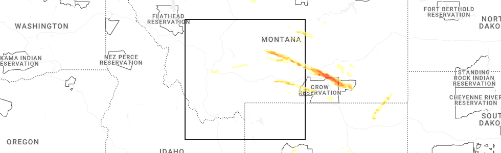
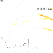
Hail Map for Wheatland, MT
The Wheatland, MT area has had 0 reports of on-the-ground hail by trained spotters, and has been under severe weather warnings 3 times during the past 12 months. Doppler radar has detected hail at or near Wheatland, MT on 16 occasions, including 2 occasions during the past year.
| Name: | Wheatland, MT |
| Where Located: | 31 miles WNW of Bozeman, MT |
| Map: | Google Map for Wheatland, MT |
| Population: | 568 |
| Housing Units: | 224 |
| More Info: | Search Google for Wheatland, MT |
0
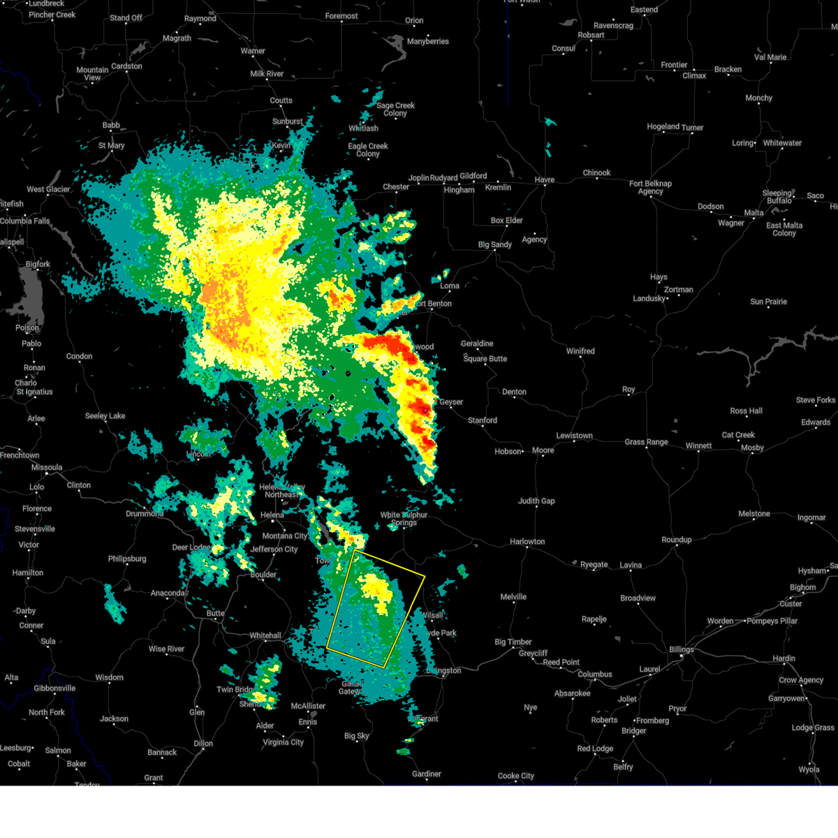
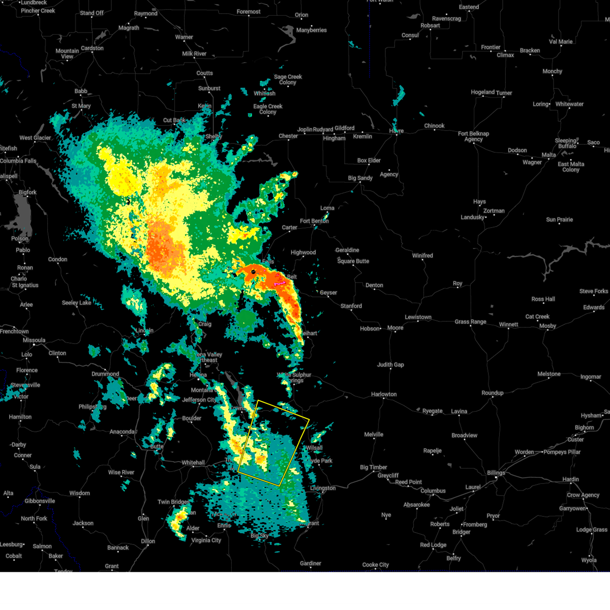
The Top Recent Hail Date for Wheatland, MT is Friday, June 13, 2025 (16th out of 16)
Hail and Wind Damage Spotted near Wheatland, MT
| Date / Time | Report Details |
|---|---|
| 6/13/2025 1:16 PM MDT |
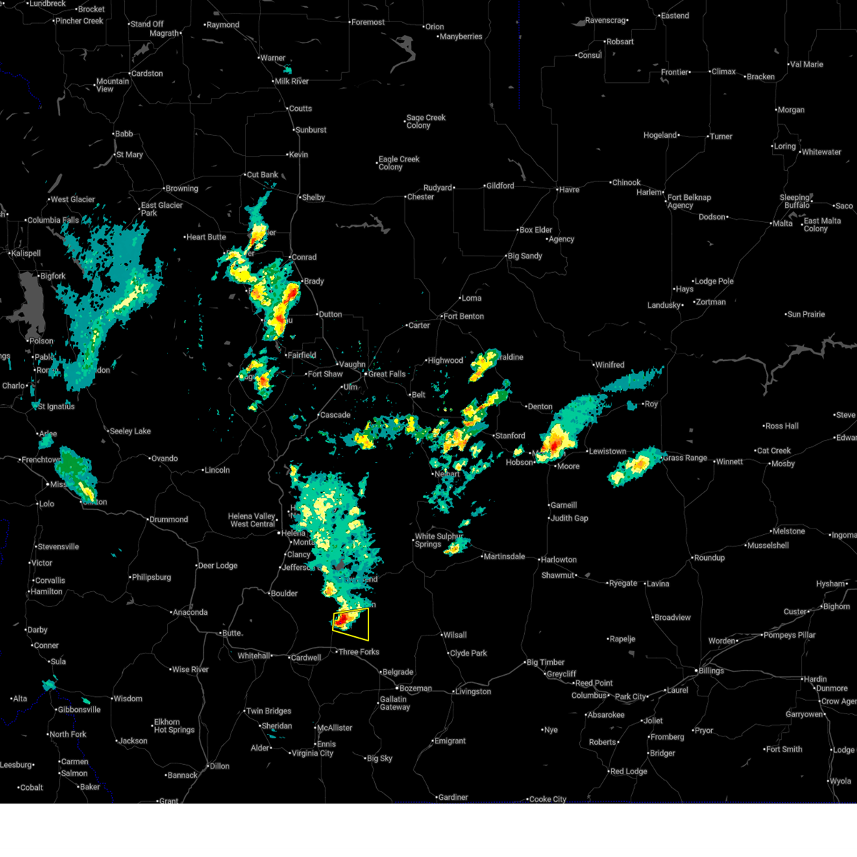 Svrtfx the national weather service in great falls has issued a * severe thunderstorm warning for, south central broadwater county in southwestern montana, northern gallatin county in south central montana, * until 145 pm mdt. * at 116 pm mdt, a severe thunderstorm was located 8 miles southwest of toston, or 18 miles south of townsend, moving east at 25 mph (radar indicated). Hazards include quarter size hail. Damage to vehicles is expected. This severe thunderstorm will remain over mainly rural areas of south central broadwater and northern gallatin counties. Svrtfx the national weather service in great falls has issued a * severe thunderstorm warning for, south central broadwater county in southwestern montana, northern gallatin county in south central montana, * until 145 pm mdt. * at 116 pm mdt, a severe thunderstorm was located 8 miles southwest of toston, or 18 miles south of townsend, moving east at 25 mph (radar indicated). Hazards include quarter size hail. Damage to vehicles is expected. This severe thunderstorm will remain over mainly rural areas of south central broadwater and northern gallatin counties.
|
| 9/11/2024 7:56 PM MDT |
 The storm which prompted the warning has weakened below severe limits, and no longer poses an immediate threat to life or property. therefore, the warning will be allowed to expire. however, gusty winds to 50 mph are still possible with this thunderstorm. The storm which prompted the warning has weakened below severe limits, and no longer poses an immediate threat to life or property. therefore, the warning will be allowed to expire. however, gusty winds to 50 mph are still possible with this thunderstorm.
|
| 9/11/2024 7:30 PM MDT |
 Svrtfx the national weather service in great falls has issued a * severe thunderstorm warning for, southeastern broadwater county in southwestern montana, south central meagher county in central montana, northeastern gallatin county in south central montana, * until 800 pm mdt. * at 730 pm mdt, a severe thunderstorm was located 11 miles northeast of manhattan, or 22 miles north of bozeman, moving northeast at 40 mph (radar indicated). Hazards include 70 mph wind gusts. Expect considerable tree damage. Damage is likely to mobile homes, roofs, and outbuildings. Svrtfx the national weather service in great falls has issued a * severe thunderstorm warning for, southeastern broadwater county in southwestern montana, south central meagher county in central montana, northeastern gallatin county in south central montana, * until 800 pm mdt. * at 730 pm mdt, a severe thunderstorm was located 11 miles northeast of manhattan, or 22 miles north of bozeman, moving northeast at 40 mph (radar indicated). Hazards include 70 mph wind gusts. Expect considerable tree damage. Damage is likely to mobile homes, roofs, and outbuildings.
|
| 8/29/2023 8:48 PM MDT |
 At 847 pm mdt, severe thunderstorms were located along a line extending from near three forks to 18 miles northeast of ennis to 18 miles west of crescent lake to 11 miles north of henrys lake in idaho, moving northeast at 20 mph (radar indicated). Hazards include 60 mph wind gusts. Expect damage to roofs, siding, and trees. locations impacted include, three forks, manhattan, big sky, bozeman hot springs, gallatin gateway, targhee pass, missouri headwaters state park, raynolds pass, logan, red rock pass, amsterdam, four corners, trident, church hill, willow creek, and madison buffalo jump state park. hail threat, radar indicated max hail size, <. 75 in wind threat, radar indicated max wind gust, 60 mph. At 847 pm mdt, severe thunderstorms were located along a line extending from near three forks to 18 miles northeast of ennis to 18 miles west of crescent lake to 11 miles north of henrys lake in idaho, moving northeast at 20 mph (radar indicated). Hazards include 60 mph wind gusts. Expect damage to roofs, siding, and trees. locations impacted include, three forks, manhattan, big sky, bozeman hot springs, gallatin gateway, targhee pass, missouri headwaters state park, raynolds pass, logan, red rock pass, amsterdam, four corners, trident, church hill, willow creek, and madison buffalo jump state park. hail threat, radar indicated max hail size, <. 75 in wind threat, radar indicated max wind gust, 60 mph.
|
| 8/29/2023 8:18 PM MDT |
 At 817 pm mdt, severe thunderstorms were located along a line extending from near harrison to 11 miles east of ennis to 21 miles west of divide lake to 15 miles northeast of kilgore, moving northeast at 20 mph (radar indicated). Hazards include 60 mph wind gusts. hail up to pea size. expect damage to roofs, siding, and trees At 817 pm mdt, severe thunderstorms were located along a line extending from near harrison to 11 miles east of ennis to 21 miles west of divide lake to 15 miles northeast of kilgore, moving northeast at 20 mph (radar indicated). Hazards include 60 mph wind gusts. hail up to pea size. expect damage to roofs, siding, and trees
|
| 7/13/2022 3:50 PM MDT |
 The severe thunderstorm warning for south central broadwater, southeastern jefferson and northern gallatin counties will expire at 400 pm mdt, the storm which prompted the warning has weakened below severe limits, and no longer poses an immediate threat to life or property. therefore, the warning will be allowed to expire. a severe thunderstorm watch remains in effect until 900 pm mdt for south central and southwestern montana. The severe thunderstorm warning for south central broadwater, southeastern jefferson and northern gallatin counties will expire at 400 pm mdt, the storm which prompted the warning has weakened below severe limits, and no longer poses an immediate threat to life or property. therefore, the warning will be allowed to expire. a severe thunderstorm watch remains in effect until 900 pm mdt for south central and southwestern montana.
|
| 7/13/2022 3:47 PM MDT |
 At 347 pm mdt, a severe thunderstorm was located over manhattan, or 20 miles northwest of bozeman, moving northeast at 25 mph (radar indicated). Hazards include 60 mph wind gusts. Expect damage to roofs, siding, and trees. locations impacted include, belgrade, three forks, manhattan, logan, amsterdam, trident, church hill, willow creek, menard, madison buffalo jump state park and missouri headwaters state park. hail threat, radar indicated max hail size, <. 75 in wind threat, radar indicated max wind gust, 60 mph. At 347 pm mdt, a severe thunderstorm was located over manhattan, or 20 miles northwest of bozeman, moving northeast at 25 mph (radar indicated). Hazards include 60 mph wind gusts. Expect damage to roofs, siding, and trees. locations impacted include, belgrade, three forks, manhattan, logan, amsterdam, trident, church hill, willow creek, menard, madison buffalo jump state park and missouri headwaters state park. hail threat, radar indicated max hail size, <. 75 in wind threat, radar indicated max wind gust, 60 mph.
|
| 7/13/2022 3:41 PM MDT |
 At 340 pm mdt, a severe thunderstorm was located near three forks, or 24 miles northwest of bozeman, moving northeast at 25 mph (radar indicated). Hazards include 60 mph wind gusts. Expect damage to roofs, siding, and trees. locations impacted include, belgrade, three forks, manhattan, logan, amsterdam, trident, church hill, willow creek, menard, madison buffalo jump state park and missouri headwaters state park. hail threat, radar indicated max hail size, <. 75 in wind threat, radar indicated max wind gust, 60 mph. At 340 pm mdt, a severe thunderstorm was located near three forks, or 24 miles northwest of bozeman, moving northeast at 25 mph (radar indicated). Hazards include 60 mph wind gusts. Expect damage to roofs, siding, and trees. locations impacted include, belgrade, three forks, manhattan, logan, amsterdam, trident, church hill, willow creek, menard, madison buffalo jump state park and missouri headwaters state park. hail threat, radar indicated max hail size, <. 75 in wind threat, radar indicated max wind gust, 60 mph.
|
| 7/13/2022 3:34 PM MDT |
 At 334 pm mdt, a severe thunderstorm was located near three forks, or 24 miles northwest of bozeman, moving northeast at 25 mph (radar indicated). Hazards include 60 mph wind gusts. Expect damage to roofs, siding, and trees. locations impacted include, belgrade, three forks, manhattan, logan, amsterdam, trident, church hill, willow creek, menard, madison buffalo jump state park and missouri headwaters state park. hail threat, radar indicated max hail size, <. 75 in wind threat, radar indicated max wind gust, 60 mph. At 334 pm mdt, a severe thunderstorm was located near three forks, or 24 miles northwest of bozeman, moving northeast at 25 mph (radar indicated). Hazards include 60 mph wind gusts. Expect damage to roofs, siding, and trees. locations impacted include, belgrade, three forks, manhattan, logan, amsterdam, trident, church hill, willow creek, menard, madison buffalo jump state park and missouri headwaters state park. hail threat, radar indicated max hail size, <. 75 in wind threat, radar indicated max wind gust, 60 mph.
|
| 7/13/2022 3:21 PM MDT |
 At 320 pm mdt, a severe thunderstorm was located near three forks, or 26 miles west of bozeman, moving northeast at 15 mph (radar indicated). Hazards include 60 mph wind gusts and nickel size hail. expect damage to roofs, siding, and trees At 320 pm mdt, a severe thunderstorm was located near three forks, or 26 miles west of bozeman, moving northeast at 15 mph (radar indicated). Hazards include 60 mph wind gusts and nickel size hail. expect damage to roofs, siding, and trees
|
| 6/28/2022 3:18 PM MDT |
 At 317 pm mdt, a severe thunderstorm was located near toston, or 15 miles south of townsend, moving northeast at 40 mph (radar indicated). Hazards include 60 mph wind gusts. expect damage to roofs, siding, and trees At 317 pm mdt, a severe thunderstorm was located near toston, or 15 miles south of townsend, moving northeast at 40 mph (radar indicated). Hazards include 60 mph wind gusts. expect damage to roofs, siding, and trees
|
| 8/8/2021 5:04 PM MDT |
 At 501 pm mdt, sporadic areas of severe wind gusts continue across the warned area. many locations within the warned area have reported wind gusts of 50 to 55 mph over the last 30 minutes. a few gusts to around 60 mph are likely (trained weather spotters). Hazards include 60 mph wind gusts. Expect damage to roofs, siding, and trees. locations impacted include, bozeman, dillon, sheridan, virginia city, belgrade, three forks, manhattan, ennis, lima, pony, alder, harrison, dell, bannack pass, cameron, missouri headwaters state park, snowline, maudlow, four corners and amsterdam. hail threat, radar indicated max hail size, <. 75 in wind threat, radar indicated max wind gust, 60 mph. At 501 pm mdt, sporadic areas of severe wind gusts continue across the warned area. many locations within the warned area have reported wind gusts of 50 to 55 mph over the last 30 minutes. a few gusts to around 60 mph are likely (trained weather spotters). Hazards include 60 mph wind gusts. Expect damage to roofs, siding, and trees. locations impacted include, bozeman, dillon, sheridan, virginia city, belgrade, three forks, manhattan, ennis, lima, pony, alder, harrison, dell, bannack pass, cameron, missouri headwaters state park, snowline, maudlow, four corners and amsterdam. hail threat, radar indicated max hail size, <. 75 in wind threat, radar indicated max wind gust, 60 mph.
|
| 8/8/2021 4:29 PM MDT |
 At 429 pm mdt, areas of severe wind gusts were located along a line extending from 11 miles southeast of toston to 6 miles north of leadore, moving northeast at 45 mph (radar indicated). Hazards include 60 mph wind gusts. expect damage to roofs, siding, and trees At 429 pm mdt, areas of severe wind gusts were located along a line extending from 11 miles southeast of toston to 6 miles north of leadore, moving northeast at 45 mph (radar indicated). Hazards include 60 mph wind gusts. expect damage to roofs, siding, and trees
|
| 6/24/2020 6:54 PM MDT |
 At 653 pm mdt, a severe thunderstorm was located near three forks, or 31 miles northwest of bozeman, moving east at 10 mph (radar indicated). Hazards include 60 mph wind gusts and quarter size hail. Hail damage to vehicles is expected. expect wind damage to roofs, siding, and trees. Locations impacted include, three forks, trident, willow creek, logan, madison buffalo jump state park and missouri headwaters state park. At 653 pm mdt, a severe thunderstorm was located near three forks, or 31 miles northwest of bozeman, moving east at 10 mph (radar indicated). Hazards include 60 mph wind gusts and quarter size hail. Hail damage to vehicles is expected. expect wind damage to roofs, siding, and trees. Locations impacted include, three forks, trident, willow creek, logan, madison buffalo jump state park and missouri headwaters state park.
|
| 6/24/2020 6:38 PM MDT |
 At 638 pm mdt, a severe thunderstorm was located 7 miles west of three forks, or 32 miles south of townsend, moving east at 10 mph (radar indicated). Hazards include 60 mph wind gusts and quarter size hail. Hail damage to vehicles is expected. Expect wind damage to roofs, siding, and trees. At 638 pm mdt, a severe thunderstorm was located 7 miles west of three forks, or 32 miles south of townsend, moving east at 10 mph (radar indicated). Hazards include 60 mph wind gusts and quarter size hail. Hail damage to vehicles is expected. Expect wind damage to roofs, siding, and trees.
|
| 8/11/2019 3:42 PM MDT |
 The severe thunderstorm warning for southwestern broadwater, north central madison, northern gallatin and southeastern jefferson counties will expire at 345 pm mdt, the storms which prompted the warning have moved out of the area. therefore, the warning will be allowed to expire. a severe thunderstorm watch remains in effect until 700 pm mdt for south central and southwestern montana. The severe thunderstorm warning for southwestern broadwater, north central madison, northern gallatin and southeastern jefferson counties will expire at 345 pm mdt, the storms which prompted the warning have moved out of the area. therefore, the warning will be allowed to expire. a severe thunderstorm watch remains in effect until 700 pm mdt for south central and southwestern montana.
|
| 8/11/2019 3:27 PM MDT |
 At 326 pm mdt, severe thunderstorms were located along a line extending from near three forks to 9 miles southwest of belgrade, moving east at 55 mph (radar indicated). Hazards include 60 mph wind gusts and nickel size hail. Expect damage to roofs, siding, and trees. Locations impacted include, belgrade, three forks, manhattan, toston, missouri headwaters state park, logan, lewis and clark caverns state park, amsterdam, trident, church hill, willow creek, menard and madison buffalo jump state park. At 326 pm mdt, severe thunderstorms were located along a line extending from near three forks to 9 miles southwest of belgrade, moving east at 55 mph (radar indicated). Hazards include 60 mph wind gusts and nickel size hail. Expect damage to roofs, siding, and trees. Locations impacted include, belgrade, three forks, manhattan, toston, missouri headwaters state park, logan, lewis and clark caverns state park, amsterdam, trident, church hill, willow creek, menard and madison buffalo jump state park.
|
| 8/11/2019 3:17 PM MDT |
 At 316 pm mdt, severe thunderstorms were located along a line extending from 6 miles north of harrison to 14 miles southwest of manhattan, moving northeast at 55 mph (radar indicated). Hazards include 60 mph wind gusts and quarter size hail. Hail damage to vehicles is expected. Expect wind damage to roofs, siding, and trees. At 316 pm mdt, severe thunderstorms were located along a line extending from 6 miles north of harrison to 14 miles southwest of manhattan, moving northeast at 55 mph (radar indicated). Hazards include 60 mph wind gusts and quarter size hail. Hail damage to vehicles is expected. Expect wind damage to roofs, siding, and trees.
|
| 7/16/2019 6:55 PM MDT |
 The severe thunderstorm warning for southwestern broadwater and east central jefferson counties will expire at 700 pm mdt, the storm which prompted the warning has moved out of the area. therefore, the warning will be allowed to expire. however small hail is still possible with this thunderstorm. this storm has had a history of producing hail up to quarter size and covering the ground a few inches deep with pea size hail. The severe thunderstorm warning for southwestern broadwater and east central jefferson counties will expire at 700 pm mdt, the storm which prompted the warning has moved out of the area. therefore, the warning will be allowed to expire. however small hail is still possible with this thunderstorm. this storm has had a history of producing hail up to quarter size and covering the ground a few inches deep with pea size hail.
|
| 7/16/2019 6:33 PM MDT |
 At 632 pm mdt, a severe thunderstorm was located 13 miles northwest of three forks, moving northeast at 25 mph (trained weather spotters). Hazards include quarter size hail. Damage to vehicles is expected. this severe thunderstorm will remain over mainly rural areas of southwestern broadwater and east central jefferson counties. Quarter size hail has covered interstate 90 around cardwell with this storm. At 632 pm mdt, a severe thunderstorm was located 13 miles northwest of three forks, moving northeast at 25 mph (trained weather spotters). Hazards include quarter size hail. Damage to vehicles is expected. this severe thunderstorm will remain over mainly rural areas of southwestern broadwater and east central jefferson counties. Quarter size hail has covered interstate 90 around cardwell with this storm.
|
| 7/16/2019 6:16 PM MDT |
 At 616 pm mdt, a severe thunderstorm was located 7 miles east of whitehall, moving northeast at 20 mph (trained weather spotters). Hazards include quarter size hail. damage to vehicles is expected At 616 pm mdt, a severe thunderstorm was located 7 miles east of whitehall, moving northeast at 20 mph (trained weather spotters). Hazards include quarter size hail. damage to vehicles is expected
|
| 7/12/2019 6:29 PM MDT |
 At 628 pm mdt, a severe thunderstorm was located 10 miles northeast of whitehall, or 20 miles southeast of boulder, moving northeast at 30 mph (radar indicated). Hazards include 60 mph wind gusts and half dollar size hail. Hail damage to vehicles is expected. expect wind damage to roofs, siding, and trees. This severe thunderstorm will remain over mainly rural areas of southwestern broadwater and southeastern jefferson counties. At 628 pm mdt, a severe thunderstorm was located 10 miles northeast of whitehall, or 20 miles southeast of boulder, moving northeast at 30 mph (radar indicated). Hazards include 60 mph wind gusts and half dollar size hail. Hail damage to vehicles is expected. expect wind damage to roofs, siding, and trees. This severe thunderstorm will remain over mainly rural areas of southwestern broadwater and southeastern jefferson counties.
|
| 7/12/2019 6:13 PM MDT |
 At 612 pm mdt, a severe thunderstorm was located over whitehall, or 23 miles south of boulder, moving northeast at 30 mph (radar indicated). Hazards include 60 mph wind gusts and quarter size hail. Hail damage to vehicles is expected. Expect wind damage to roofs, siding, and trees. At 612 pm mdt, a severe thunderstorm was located over whitehall, or 23 miles south of boulder, moving northeast at 30 mph (radar indicated). Hazards include 60 mph wind gusts and quarter size hail. Hail damage to vehicles is expected. Expect wind damage to roofs, siding, and trees.
|
| 6/13/2019 2:08 PM MDT |
 At 205 pm mdt, a severe thunderstorm was located 7 miles south of toston, or 16 miles southeast of townsend, moving southeast at 10 mph (emergency management. at 145 pm, broadwater county emergency management reported hail to the size of quarters near toston). Hazards include 60 mph wind gusts and quarter size hail. Hail damage to vehicles is expected. expect wind damage to roofs, siding, and trees. Locations impacted include, toston and maudlow. At 205 pm mdt, a severe thunderstorm was located 7 miles south of toston, or 16 miles southeast of townsend, moving southeast at 10 mph (emergency management. at 145 pm, broadwater county emergency management reported hail to the size of quarters near toston). Hazards include 60 mph wind gusts and quarter size hail. Hail damage to vehicles is expected. expect wind damage to roofs, siding, and trees. Locations impacted include, toston and maudlow.
|
| 6/13/2019 1:40 PM MDT |
 At 139 pm mdt, a severe thunderstorm was located near toston, or 13 miles south of townsend, moving southeast at 10 mph (radar indicated). Hazards include 60 mph wind gusts and quarter size hail. Hail damage to vehicles is expected. Expect wind damage to roofs, siding, and trees. At 139 pm mdt, a severe thunderstorm was located near toston, or 13 miles south of townsend, moving southeast at 10 mph (radar indicated). Hazards include 60 mph wind gusts and quarter size hail. Hail damage to vehicles is expected. Expect wind damage to roofs, siding, and trees.
|
| 5/26/2018 6:55 PM MDT |
 At 648 pm mdt, a severe thunderstorm was located 10 miles northwest of three forks, or 25 miles southeast of boulder, moving north at 25 mph (radar indicated). Hazards include 60 mph wind gusts and quarter size hail. Hail damage to vehicles is expected. expect wind damage to roofs, siding, and trees. This severe thunderstorm will remain over mainly rural areas of southwestern broadwater and east central jefferson counties. At 648 pm mdt, a severe thunderstorm was located 10 miles northwest of three forks, or 25 miles southeast of boulder, moving north at 25 mph (radar indicated). Hazards include 60 mph wind gusts and quarter size hail. Hail damage to vehicles is expected. expect wind damage to roofs, siding, and trees. This severe thunderstorm will remain over mainly rural areas of southwestern broadwater and east central jefferson counties.
|
| 5/26/2018 6:48 PM MDT |
 At 648 pm mdt, a severe thunderstorm was located 10 miles northwest of three forks, or 25 miles southeast of boulder, moving north at 25 mph (radar indicated). Hazards include 60 mph wind gusts and quarter size hail. Hail damage to vehicles is expected. expect wind damage to roofs, siding, and trees. This severe thunderstorm will remain over mainly rural areas of southwestern broadwater and east central jefferson counties. At 648 pm mdt, a severe thunderstorm was located 10 miles northwest of three forks, or 25 miles southeast of boulder, moving north at 25 mph (radar indicated). Hazards include 60 mph wind gusts and quarter size hail. Hail damage to vehicles is expected. expect wind damage to roofs, siding, and trees. This severe thunderstorm will remain over mainly rural areas of southwestern broadwater and east central jefferson counties.
|
| 5/26/2018 6:35 PM MDT |
 At 634 pm mdt, a severe thunderstorm was located 11 miles west of three forks, or 28 miles southeast of boulder, moving north at 30 mph (trained weather spotters). Hazards include 60 mph wind gusts and quarter size hail. Hail damage to vehicles is expected. Expect wind damage to roofs, siding, and trees. At 634 pm mdt, a severe thunderstorm was located 11 miles west of three forks, or 28 miles southeast of boulder, moving north at 30 mph (trained weather spotters). Hazards include 60 mph wind gusts and quarter size hail. Hail damage to vehicles is expected. Expect wind damage to roofs, siding, and trees.
|
| 5/26/2018 6:24 PM MDT |
 The severe thunderstorm warning for southeastern jefferson county will expire at 630 pm mdt, the storm which prompted the warning has weakened below severe limits, and no longer poses an immediate threat to life or property. therefore, the warning will be allowed to expire. however small hail and gusty winds are still possible with this thunderstorm. The severe thunderstorm warning for southeastern jefferson county will expire at 630 pm mdt, the storm which prompted the warning has weakened below severe limits, and no longer poses an immediate threat to life or property. therefore, the warning will be allowed to expire. however small hail and gusty winds are still possible with this thunderstorm.
|
| 5/26/2018 6:07 PM MDT |
 At 607 pm mdt, a severe thunderstorm was located 13 miles west of three forks, or 24 miles southeast of boulder, moving northeast at 40 mph (radar indicated). Hazards include 60 mph wind gusts and quarter size hail. Hail damage to vehicles is expected. expect wind damage to roofs, siding, and trees. This severe thunderstorm will remain over mainly rural areas of southeastern jefferson county. At 607 pm mdt, a severe thunderstorm was located 13 miles west of three forks, or 24 miles southeast of boulder, moving northeast at 40 mph (radar indicated). Hazards include 60 mph wind gusts and quarter size hail. Hail damage to vehicles is expected. expect wind damage to roofs, siding, and trees. This severe thunderstorm will remain over mainly rural areas of southeastern jefferson county.
|
| 5/26/2018 5:54 PM MDT |
 At 554 pm mdt, a severe thunderstorm was located 9 miles east of whitehall, or 28 miles southeast of boulder, moving northeast at 20 mph (radar indicated). Hazards include 60 mph wind gusts and quarter size hail. Hail damage to vehicles is expected. Expect wind damage to roofs, siding, and trees. At 554 pm mdt, a severe thunderstorm was located 9 miles east of whitehall, or 28 miles southeast of boulder, moving northeast at 20 mph (radar indicated). Hazards include 60 mph wind gusts and quarter size hail. Hail damage to vehicles is expected. Expect wind damage to roofs, siding, and trees.
|
| 6/1/2015 3:52 PM MDT | At 351 pm mdt, doppler radar indicated a severe thunderstorm capable of producing quarter size hail and damaging winds in excess of 60 mph. this storm was located near three forks, moving northeast at 35 mph. locations impacted include, three forks, manhattan, toston, logan, maudlow and trident. |
| 6/1/2015 3:36 PM MDT | At 335 pm mdt, doppler radar indicated a severe thunderstorm capable of producing quarter size hail and damaging winds in excess of 60 mph. this storm was located near three forks moving northeast at 35 mph. |
| 9/5/2013 7:32 PM MDT | Spotter also reported very heavy rainfall in jefferson county MT, 18.8 miles ESE of Wheatland, MT |
| 9/5/2013 7:30 PM MDT | 79 mph wind gust...with a pivot tipped ove in jefferson county MT, 18.8 miles ESE of Wheatland, MT |
Hail Maps for Wheatland, MT


Connect with Interactive Hail Maps