

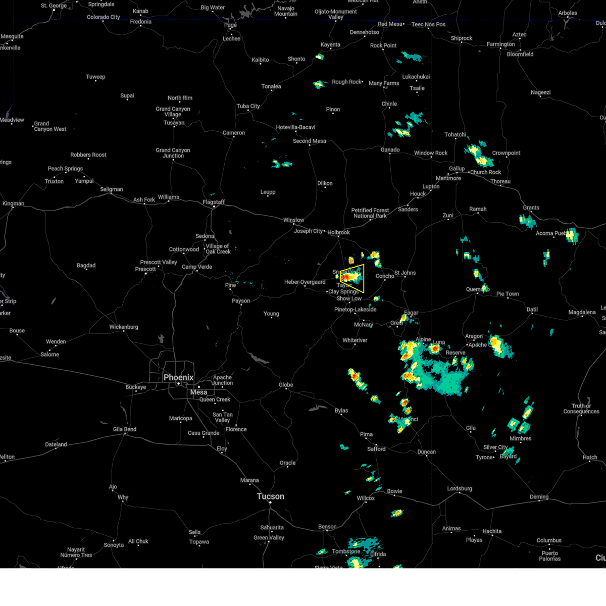
Hail Map for White Mountain Lake, AZ
The White Mountain Lake, AZ area has had 0 reports of on-the-ground hail by trained spotters, and has been under severe weather warnings 3 times during the past 12 months. Doppler radar has detected hail at or near White Mountain Lake, AZ on 21 occasions, including 1 occasion during the past year.
| Name: | White Mountain Lake, AZ |
| Where Located: | 7.7 miles NNE of Show Low, AZ |
| Map: | Google Map for White Mountain Lake, AZ |
| Population: | 2205 |
| Housing Units: | 1772 |
| More Info: | Search Google for White Mountain Lake, AZ |
0
The Top Recent Hail Date for White Mountain Lake, AZ is Wednesday, August 21, 2024 (21st out of 21)

Hail and Wind Damage Spotted near White Mountain Lake, AZ
| Date / Time | Report Details |
|---|---|
| 7/27/2024 1:29 PM MST |
 The storm which prompted the warning has weakened below severe limits, and no longer poses an immediate threat to life or property. therefore, the warning will be allowed to expire. however, small hail and heavy rain are still possible with this thunderstorm. The storm which prompted the warning has weakened below severe limits, and no longer poses an immediate threat to life or property. therefore, the warning will be allowed to expire. however, small hail and heavy rain are still possible with this thunderstorm.
|
| 7/27/2024 1:20 PM MST |
 At 120 pm mst, a severe thunderstorm was located near taylor, or 17 miles north of show low, moving east at 15 mph (radar indicated). Hazards include 60 mph wind gusts and quarter size hail. Hail damage to vehicles is expected. expect wind damage to roofs, siding, and trees. locations impacted include, taylor airport, taylor, pioneer park, and snowflake. this includes the following highways, state route 277 between mile markers 333 and 336. State route 77 between mile markers 357 and 365. At 120 pm mst, a severe thunderstorm was located near taylor, or 17 miles north of show low, moving east at 15 mph (radar indicated). Hazards include 60 mph wind gusts and quarter size hail. Hail damage to vehicles is expected. expect wind damage to roofs, siding, and trees. locations impacted include, taylor airport, taylor, pioneer park, and snowflake. this includes the following highways, state route 277 between mile markers 333 and 336. State route 77 between mile markers 357 and 365.
|
| 7/27/2024 1:05 PM MST |
 Svrfgz the national weather service in flagstaff has issued a * severe thunderstorm warning for, apache county in northeastern arizona, navajo county in north central arizona, * until 130 pm mst. * at 104 pm mst, a severe thunderstorm was located over taylor, or 17 miles north of show low, moving east at 15 mph (radar indicated). Hazards include 60 mph wind gusts and quarter size hail. Hail damage to vehicles is expected. Expect wind damage to roofs, siding, and trees. Svrfgz the national weather service in flagstaff has issued a * severe thunderstorm warning for, apache county in northeastern arizona, navajo county in north central arizona, * until 130 pm mst. * at 104 pm mst, a severe thunderstorm was located over taylor, or 17 miles north of show low, moving east at 15 mph (radar indicated). Hazards include 60 mph wind gusts and quarter size hail. Hail damage to vehicles is expected. Expect wind damage to roofs, siding, and trees.
|
| 9/13/2023 4:55 PM MST |
 At 453 pm mst, a severe thunderstorm was located near ned lake, or 8 miles northwest of show low, moving southeast at 15 mph (radar indicated). Hazards include quarter size hail. Damage to vehicles is expected. locations impacted include, show low, shumway, schoens lake, fool hollow lake, telephone lake, ned lake, pintail lake, white mountain lake estates, fool hollow lake campground, and white mountain lake. this includes the following highways, state route 260 between mile markers 333 and 336. state route 77 between mile markers 346 and 354. hail threat, radar indicated max hail size, 1. 00 in wind threat, radar indicated max wind gust, <50 mph. At 453 pm mst, a severe thunderstorm was located near ned lake, or 8 miles northwest of show low, moving southeast at 15 mph (radar indicated). Hazards include quarter size hail. Damage to vehicles is expected. locations impacted include, show low, shumway, schoens lake, fool hollow lake, telephone lake, ned lake, pintail lake, white mountain lake estates, fool hollow lake campground, and white mountain lake. this includes the following highways, state route 260 between mile markers 333 and 336. state route 77 between mile markers 346 and 354. hail threat, radar indicated max hail size, 1. 00 in wind threat, radar indicated max wind gust, <50 mph.
|
| 9/13/2023 4:25 PM MST |
 At 423 pm mst, a severe thunderstorm was located near clay springs, or 15 miles northwest of show low, moving southeast at 20 mph (radar indicated). Hazards include 60 mph wind gusts and quarter size hail. Hail damage to vehicles is expected. Expect wind damage to roofs, siding, and trees. At 423 pm mst, a severe thunderstorm was located near clay springs, or 15 miles northwest of show low, moving southeast at 20 mph (radar indicated). Hazards include 60 mph wind gusts and quarter size hail. Hail damage to vehicles is expected. Expect wind damage to roofs, siding, and trees.
|
| 7/11/2023 5:12 PM MST |
 The severe thunderstorm warning for apache and navajo counties will expire at 515 pm mst, the storm which prompted the warning has weakened below severe limits, and no longer poses an immediate threat to life or property. therefore, the warning will be allowed to expire. however heavy rain is still possible with this thunderstorm. The severe thunderstorm warning for apache and navajo counties will expire at 515 pm mst, the storm which prompted the warning has weakened below severe limits, and no longer poses an immediate threat to life or property. therefore, the warning will be allowed to expire. however heavy rain is still possible with this thunderstorm.
|
| 7/11/2023 5:03 PM MST |
 At 502 pm mst, a severe thunderstorm was located near show low, moving east at 5 mph. this storm is producing heavy rain, and some locations in the warned area have picked up about one inch of rainfall over the last hour. ponding on area roadways is possible (radar indicated). Hazards include 60 mph wind gusts and penny size hail. Expect damage to roofs, siding, and trees. locations impacted include, show low and scott reservoir campground. this includes the following highways, state route 260 near mile marker 345. state route 77 between mile markers 343 and 344. highway 60 between mile markers 342 and 352. hail threat, radar indicated max hail size, 0. 75 in wind threat, radar indicated max wind gust, 60 mph. At 502 pm mst, a severe thunderstorm was located near show low, moving east at 5 mph. this storm is producing heavy rain, and some locations in the warned area have picked up about one inch of rainfall over the last hour. ponding on area roadways is possible (radar indicated). Hazards include 60 mph wind gusts and penny size hail. Expect damage to roofs, siding, and trees. locations impacted include, show low and scott reservoir campground. this includes the following highways, state route 260 near mile marker 345. state route 77 between mile markers 343 and 344. highway 60 between mile markers 342 and 352. hail threat, radar indicated max hail size, 0. 75 in wind threat, radar indicated max wind gust, 60 mph.
|
| 7/11/2023 4:24 PM MST |
 At 423 pm mst, a severe thunderstorm was located over show low, moving east at 10 mph (radar indicated). Hazards include 60 mph wind gusts and penny size hail. expect damage to roofs, siding, and trees At 423 pm mst, a severe thunderstorm was located over show low, moving east at 10 mph (radar indicated). Hazards include 60 mph wind gusts and penny size hail. expect damage to roofs, siding, and trees
|
| 5/14/2023 12:27 PM MST |
 At 1227 pm mst, a severe thunderstorm was located near show low, moving northwest at 15 mph (radar indicated). Hazards include 60 mph wind gusts. Expect damage to roofs, siding, and trees. locations impacted include, show low, pinetop-lakeside, lake of the woods--pinetop-lakeside, wagon wheel, pinetop country club, scott reservoir campground, fool hollow lake campground, white mountain lake and lakeside campground. this includes the following highways, state route 260 between mile markers 335 and 356. state route 77 between mile markers 343 and 348. highway 60 between mile markers 337 and 349. hail threat, radar indicated max hail size, <. 75 in wind threat, radar indicated max wind gust, 60 mph. At 1227 pm mst, a severe thunderstorm was located near show low, moving northwest at 15 mph (radar indicated). Hazards include 60 mph wind gusts. Expect damage to roofs, siding, and trees. locations impacted include, show low, pinetop-lakeside, lake of the woods--pinetop-lakeside, wagon wheel, pinetop country club, scott reservoir campground, fool hollow lake campground, white mountain lake and lakeside campground. this includes the following highways, state route 260 between mile markers 335 and 356. state route 77 between mile markers 343 and 348. highway 60 between mile markers 337 and 349. hail threat, radar indicated max hail size, <. 75 in wind threat, radar indicated max wind gust, 60 mph.
|
| 5/14/2023 11:54 AM MST |
 At 1154 am mst, a severe thunderstorm was located near pinetop-lakeside, or 11 miles southeast of show low, moving northwest at 15 mph (radar indicated). Hazards include 60 mph wind gusts and nickel size hail. expect damage to roofs, siding, and trees At 1154 am mst, a severe thunderstorm was located near pinetop-lakeside, or 11 miles southeast of show low, moving northwest at 15 mph (radar indicated). Hazards include 60 mph wind gusts and nickel size hail. expect damage to roofs, siding, and trees
|
| 8/26/2022 4:21 PM MST | The severe thunderstorm warning for navajo county will expire at 430 pm mst, the storm which prompted the warning has weakened below severe limits, and no longer poses an immediate threat to life or property. therefore, the warning will be allowed to expire. however gusty winds and heavy rain are still possible with this thunderstorm. |
| 8/26/2022 4:13 PM MST | At 413 pm mst, a severe thunderstorm was located over taylor, moving east at 15 mph (trained weather spotters reported penny size hail). Hazards include 60 mph wind gusts and quarter size hail. Hail damage to vehicles is expected. expect wind damage to roofs, siding, and trees. locations impacted include, taylor, shumway, snowflake and white mountain lake. hail threat, radar indicated max hail size, 1. 00 in wind threat, radar indicated max wind gust, 60 mph. |
| 8/26/2022 3:56 PM MST | At 356 pm mst, a severe thunderstorm was located near taylor, moving east at 15 mph (radar indicated). Hazards include 60 mph wind gusts and quarter size hail. Hail damage to vehicles is expected. Expect wind damage to roofs, siding, and trees. |
| 7/17/2022 1:16 PM MST |
 At 113 pm mst, a severe thunderstorm was located 7 miles east of show low, moving northeast at 15 mph (public report of quarter size hail. radar indicated rotation within the storm). Hazards include 60 mph wind gusts, quarter size hail, and heavy rainfall. Hail damage to vehicles is expected. Expect wind damage to roofs, siding, and trees. At 113 pm mst, a severe thunderstorm was located 7 miles east of show low, moving northeast at 15 mph (public report of quarter size hail. radar indicated rotation within the storm). Hazards include 60 mph wind gusts, quarter size hail, and heavy rainfall. Hail damage to vehicles is expected. Expect wind damage to roofs, siding, and trees.
|
| 7/17/2022 12:38 PM MST |
 At 1236 pm mst, a severe thunderstorm was located over wagon wheel, or over show low, moving north at 10 to 15 mph (radar indicated). Hazards include 60 mph wind gusts, quarter size hail, and heavy rainfall. Hail damage to vehicles is expected. Expect wind damage to roofs, siding, and trees. At 1236 pm mst, a severe thunderstorm was located over wagon wheel, or over show low, moving north at 10 to 15 mph (radar indicated). Hazards include 60 mph wind gusts, quarter size hail, and heavy rainfall. Hail damage to vehicles is expected. Expect wind damage to roofs, siding, and trees.
|
| 10/5/2021 5:25 PM MST |
 The severe thunderstorm warning for apache and navajo counties will expire at 530 pm mst, the storm which prompted the warning west of concho has weakened below severe limits, but could still produce small hail and very heavy rainfall. therefore, the warning will be allowed to expire at 5:30 pm mst this evening. a severe thunderstorm watch remains in effect until 800 pm mst for north central arizona. The severe thunderstorm warning for apache and navajo counties will expire at 530 pm mst, the storm which prompted the warning west of concho has weakened below severe limits, but could still produce small hail and very heavy rainfall. therefore, the warning will be allowed to expire at 5:30 pm mst this evening. a severe thunderstorm watch remains in effect until 800 pm mst for north central arizona.
|
| 10/5/2021 5:18 PM MST |
 At 517 pm mst, a severe thunderstorm was located 11 miles east of shumway, or 16 miles northeast of show low, moving northeast at 20 mph (radar indicated). Hazards include 60 mph wind gusts and half dollar size hail. Hail damage to vehicles is expected. expect wind damage to roofs, siding, and trees. this severe thunderstorm will remain over mainly rural areas of apache and navajo counties. hail threat, radar indicated max hail size, 1. 25 in wind threat, radar indicated max wind gust, 60 mph. At 517 pm mst, a severe thunderstorm was located 11 miles east of shumway, or 16 miles northeast of show low, moving northeast at 20 mph (radar indicated). Hazards include 60 mph wind gusts and half dollar size hail. Hail damage to vehicles is expected. expect wind damage to roofs, siding, and trees. this severe thunderstorm will remain over mainly rural areas of apache and navajo counties. hail threat, radar indicated max hail size, 1. 25 in wind threat, radar indicated max wind gust, 60 mph.
|
| 10/5/2021 5:06 PM MST |
 At 505 pm mst, a severe thunderstorm was located 7 miles east of shumway, or 12 miles northeast of show low, moving northeast at 20 mph (radar indicated). Hazards include 60 mph wind gusts and half dollar size hail. Hail damage to vehicles is expected. expect wind damage to roofs, siding, and trees. locations impacted include, shumway and white mountain lake. hail threat, radar indicated max hail size, 1. 25 in wind threat, radar indicated max wind gust, 60 mph. At 505 pm mst, a severe thunderstorm was located 7 miles east of shumway, or 12 miles northeast of show low, moving northeast at 20 mph (radar indicated). Hazards include 60 mph wind gusts and half dollar size hail. Hail damage to vehicles is expected. expect wind damage to roofs, siding, and trees. locations impacted include, shumway and white mountain lake. hail threat, radar indicated max hail size, 1. 25 in wind threat, radar indicated max wind gust, 60 mph.
|
| 10/5/2021 4:49 PM MST |
 At 449 pm mst, a severe thunderstorm was located near shumway, or 7 miles north of show low, moving northeast at 20 mph (radar indicated). Hazards include 60 mph wind gusts and half dollar size hail. Hail damage to vehicles is expected. Expect wind damage to roofs, siding, and trees. At 449 pm mst, a severe thunderstorm was located near shumway, or 7 miles north of show low, moving northeast at 20 mph (radar indicated). Hazards include 60 mph wind gusts and half dollar size hail. Hail damage to vehicles is expected. Expect wind damage to roofs, siding, and trees.
|
| 8/15/2021 7:53 PM MST |
 At 753 pm mst, a severe thunderstorm was located over show low, moving southwest at 10 mph (radar indicated). Hazards include quarter size hail. damage to vehicles is expected At 753 pm mst, a severe thunderstorm was located over show low, moving southwest at 10 mph (radar indicated). Hazards include quarter size hail. damage to vehicles is expected
|
| 7/9/2021 5:32 PM MST |
 At 531 pm mst, a severe thunderstorm was located near linden, or 7 miles northwest of show low, moving southwest at 15 mph (radar indicated). Hazards include 60 mph wind gusts and quarter size hail. Hail damage to vehicles is expected. Expect wind damage to roofs, siding, and trees. At 531 pm mst, a severe thunderstorm was located near linden, or 7 miles northwest of show low, moving southwest at 15 mph (radar indicated). Hazards include 60 mph wind gusts and quarter size hail. Hail damage to vehicles is expected. Expect wind damage to roofs, siding, and trees.
|
| 5/8/2019 3:59 PM MST |
 At 358 pm mst, a severe thunderstorm was located 7 miles northwest of taylor, or 21 miles north of show low, moving southeast at 45 mph (radar indicated). Hazards include quarter size hail. damage to vehicles is expected At 358 pm mst, a severe thunderstorm was located 7 miles northwest of taylor, or 21 miles north of show low, moving southeast at 45 mph (radar indicated). Hazards include quarter size hail. damage to vehicles is expected
|
| 8/13/2018 7:42 PM MST |
 At 740 pm mst, a severe thunderstorm was located near show low, moving south at 20 mph (radar indicated). Hazards include quarter size hail and wind gusts 40 mph. damage to vehicles is possible At 740 pm mst, a severe thunderstorm was located near show low, moving south at 20 mph (radar indicated). Hazards include quarter size hail and wind gusts 40 mph. damage to vehicles is possible
|
| 8/13/2018 7:23 PM MST |
 At 722 pm mst, a severe thunderstorm was located 12 miles northwest of vernon, moving south at 15 mph (radar indicated). Hazards include quarter size hail and wind gusts to 40 mph. Damage to vehicles is possible. this includes the following highways, highway 60 between mile markers 344 and 357. State route 61 between mile markers 353 and 357. At 722 pm mst, a severe thunderstorm was located 12 miles northwest of vernon, moving south at 15 mph (radar indicated). Hazards include quarter size hail and wind gusts to 40 mph. Damage to vehicles is possible. this includes the following highways, highway 60 between mile markers 344 and 357. State route 61 between mile markers 353 and 357.
|
| 8/9/2018 3:50 PM MST |
 At 349 pm mst, a severe thunderstorm was located 7 miles northwest of taylor, or 22 miles north of show low, moving south at 15 mph (radar indicated). Hazards include 60 mph wind gusts and half dollar size hail. Hail damage to vehicles is expected. expect wind damage to roofs, siding, and trees. locations impacted include, taylor, clay springs, aripine, shumway, snowflake and dry lake. this includes the following highways, state route 277 between mile markers 315 and 336. state route 260 between mile markers 314 and 325. state route 377 between mile markers 5 and 16. State route 77 between mile markers 351 and 374. At 349 pm mst, a severe thunderstorm was located 7 miles northwest of taylor, or 22 miles north of show low, moving south at 15 mph (radar indicated). Hazards include 60 mph wind gusts and half dollar size hail. Hail damage to vehicles is expected. expect wind damage to roofs, siding, and trees. locations impacted include, taylor, clay springs, aripine, shumway, snowflake and dry lake. this includes the following highways, state route 277 between mile markers 315 and 336. state route 260 between mile markers 314 and 325. state route 377 between mile markers 5 and 16. State route 77 between mile markers 351 and 374.
|
| 8/9/2018 3:33 PM MST |
 At 333 pm mst, a severe thunderstorm was located 12 miles north of taylor, or 27 miles north of show low, moving south at 15 mph (radar indicated). Hazards include 60 mph wind gusts and quarter size hail. Hail damage to vehicles is expected. Expect wind damage to roofs, siding, and trees. At 333 pm mst, a severe thunderstorm was located 12 miles north of taylor, or 27 miles north of show low, moving south at 15 mph (radar indicated). Hazards include 60 mph wind gusts and quarter size hail. Hail damage to vehicles is expected. Expect wind damage to roofs, siding, and trees.
|
| 9/27/2016 3:51 PM MST |
 At 349 pm mst, doppler radar indicated a severe thunderstorm capable of producing quarter size hail. this storm was located near shumway, or 9 miles north of show low, moving northwest at 20 mph. in addition, at 343 pm one inch diameter hail was reported 3 miles northeast of show low airpor. locations impacted include, white mountain lake, los burros campground and brown creek campground. At 349 pm mst, doppler radar indicated a severe thunderstorm capable of producing quarter size hail. this storm was located near shumway, or 9 miles north of show low, moving northwest at 20 mph. in addition, at 343 pm one inch diameter hail was reported 3 miles northeast of show low airpor. locations impacted include, white mountain lake, los burros campground and brown creek campground.
|
| 9/27/2016 3:24 PM MST |
 The national weather service in flagstaff has issued a * severe thunderstorm warning for. apache county in northeastern arizona. navajo county in north central arizona. until 400 pm mst * at 324 pm mst. Doppler radar indicated a severe thunderstorm. The national weather service in flagstaff has issued a * severe thunderstorm warning for. apache county in northeastern arizona. navajo county in north central arizona. until 400 pm mst * at 324 pm mst. Doppler radar indicated a severe thunderstorm.
|
| 6/5/2015 5:57 PM MST | The severe thunderstorm warning for southeastern navajo and southern apache counties will expire at 600 pm mst, the storm which prompted the warning has weakened below severe limits, and no longer poses an immediate threat to life or property. therefore the warning will be allowed to expire. however gusty winds and heavy rain are still possible with this thunderstorm, including the show low area. |
| 6/5/2015 5:35 PM MST | At 534 pm mst, doppler radar indicated a severe thunderstorm capable of producing large damaging hail up to golf ball size and destructive winds in excess of 70 mph. this storm was located near milepost 330 on hwy 60, or 11 miles southwest of show low, and moving northeast at 50 mph. |
Hail Maps for White Mountain Lake, AZ


Connect with Interactive Hail Maps