

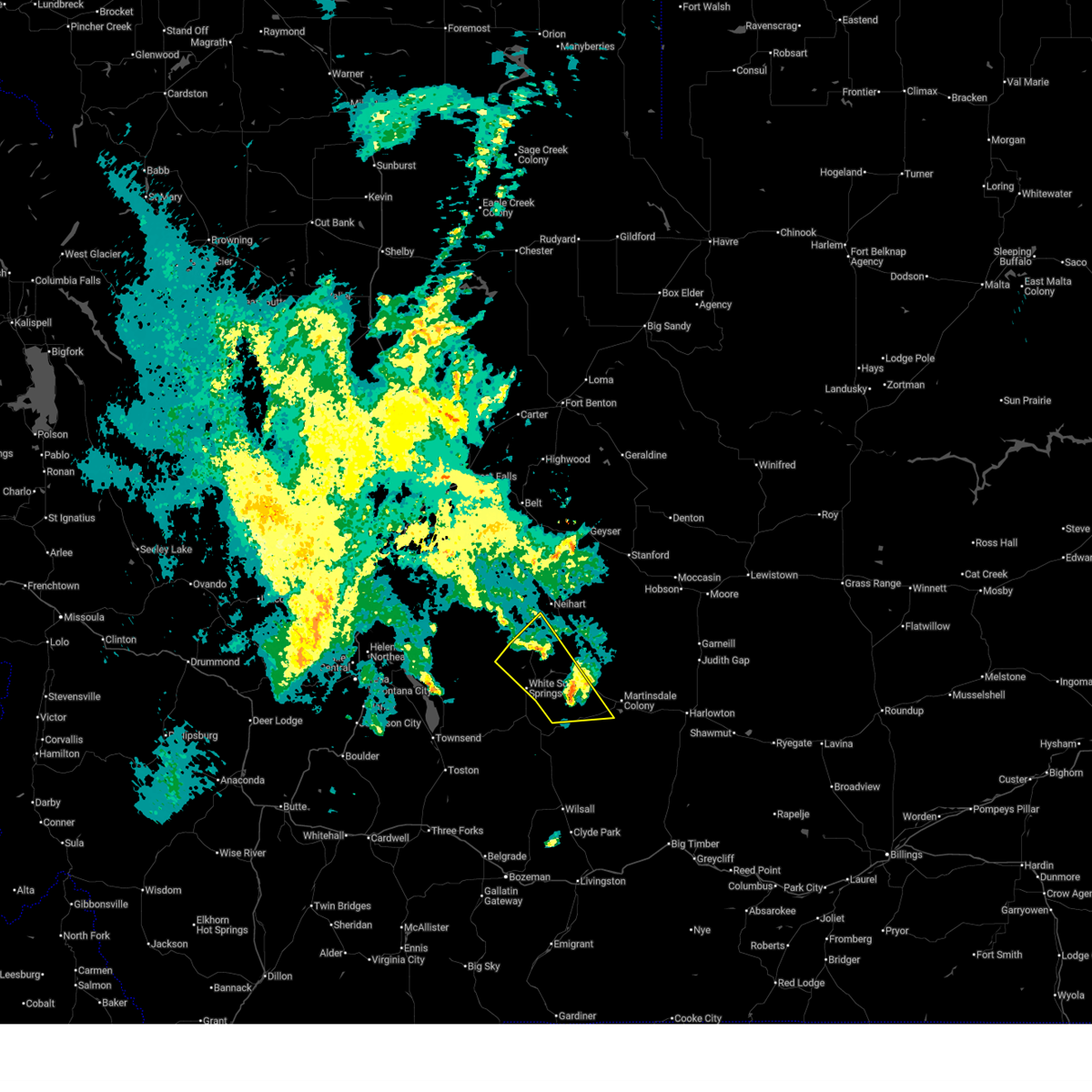
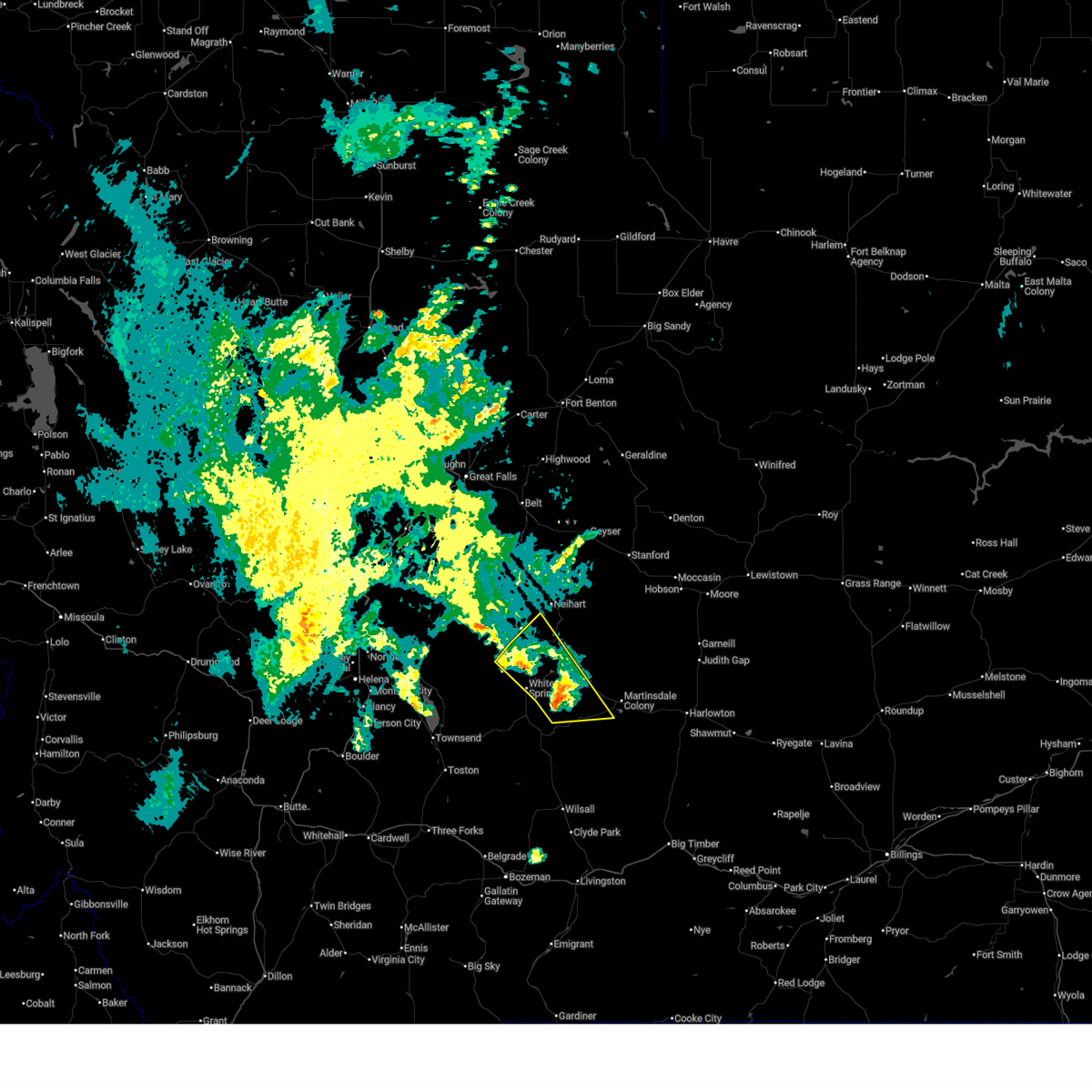
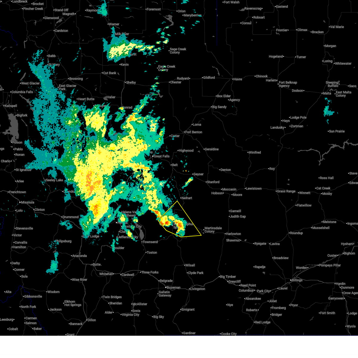
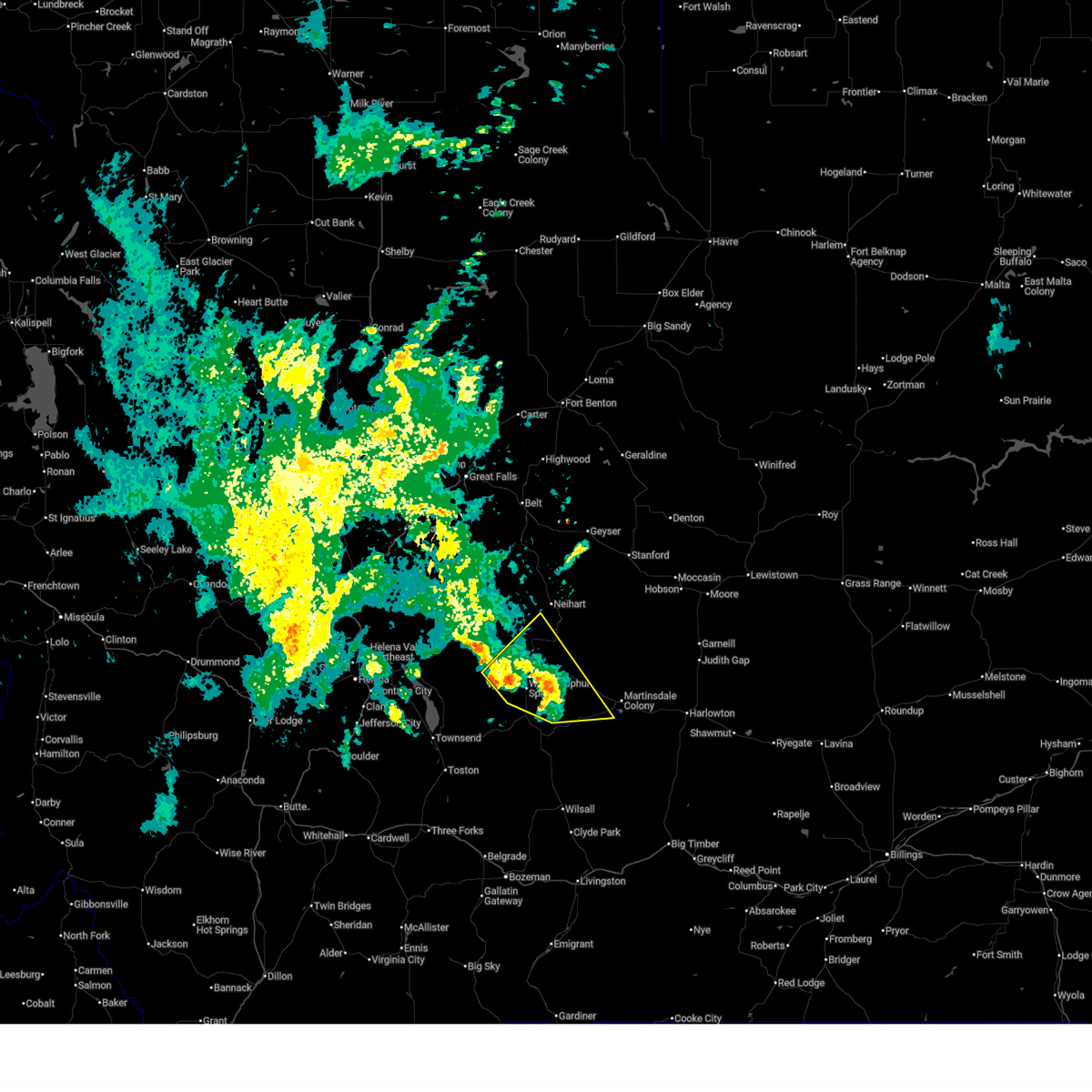
Hail Map for White Sulphur Springs, MT
The White Sulphur Springs, MT area has had 7 reports of on-the-ground hail by trained spotters, and has been under severe weather warnings 7 times during the past 12 months. Doppler radar has detected hail at or near White Sulphur Springs, MT on 9 occasions.
| Name: | White Sulphur Springs, MT |
| Where Located: | 60.3 miles N of Bozeman, MT |
| Map: | Google Map for White Sulphur Springs, MT |
| Population: | 939 |
| Housing Units: | 563 |
| More Info: | Search Google for White Sulphur Springs, MT |
5
The Top Recent Hail Date for White Sulphur Springs, MT is Tuesday, June 5, 2012 (1st out of 9)

Hail and Wind Damage Spotted near White Sulphur Springs, MT
| Date / Time | Report Details |
|---|---|
| 6/20/2025 4:12 PM MDT |
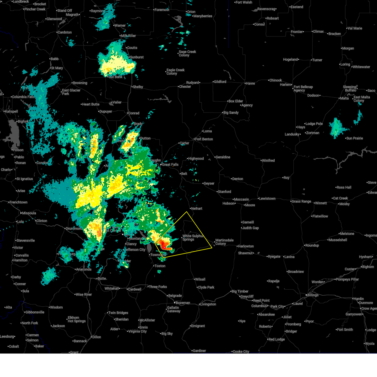
 The storm which prompted the warning has moved out of the area. therefore, the warning will be allowed to expire. however, small hail and gusty winds are still possible with this thunderstorm. The storm which prompted the warning has moved out of the area. therefore, the warning will be allowed to expire. however, small hail and gusty winds are still possible with this thunderstorm.
|
| 6/20/2025 4:00 PM MDT |
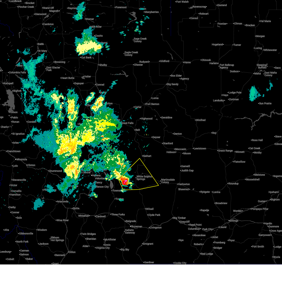
 At 359 pm mdt, a severe thunderstorm was located near white sulphur springs, moving northeast at 35 mph (radar indicated). Hazards include 60 mph wind gusts and quarter size hail. Hail damage to vehicles is expected. expect wind damage to roofs, siding, and trees. Locations impacted include, white sulphur springs, checkerboard, newlan creek reservoir, and lennep. At 359 pm mdt, a severe thunderstorm was located near white sulphur springs, moving northeast at 35 mph (radar indicated). Hazards include 60 mph wind gusts and quarter size hail. Hail damage to vehicles is expected. expect wind damage to roofs, siding, and trees. Locations impacted include, white sulphur springs, checkerboard, newlan creek reservoir, and lennep.
|
| 6/20/2025 3:50 PM MDT |
 At 349 pm mdt, a severe thunderstorm was located over white sulphur springs, moving northeast at 35 mph (radar indicated). Hazards include 60 mph wind gusts and quarter size hail. Hail damage to vehicles is expected. expect wind damage to roofs, siding, and trees. Locations impacted include, white sulphur springs, checkerboard, newlan creek reservoir, and lennep. At 349 pm mdt, a severe thunderstorm was located over white sulphur springs, moving northeast at 35 mph (radar indicated). Hazards include 60 mph wind gusts and quarter size hail. Hail damage to vehicles is expected. expect wind damage to roofs, siding, and trees. Locations impacted include, white sulphur springs, checkerboard, newlan creek reservoir, and lennep.
|
| 6/20/2025 3:50 PM MDT |
 the severe thunderstorm warning has been cancelled and is no longer in effect the severe thunderstorm warning has been cancelled and is no longer in effect
|
| 6/20/2025 3:39 PM MDT |
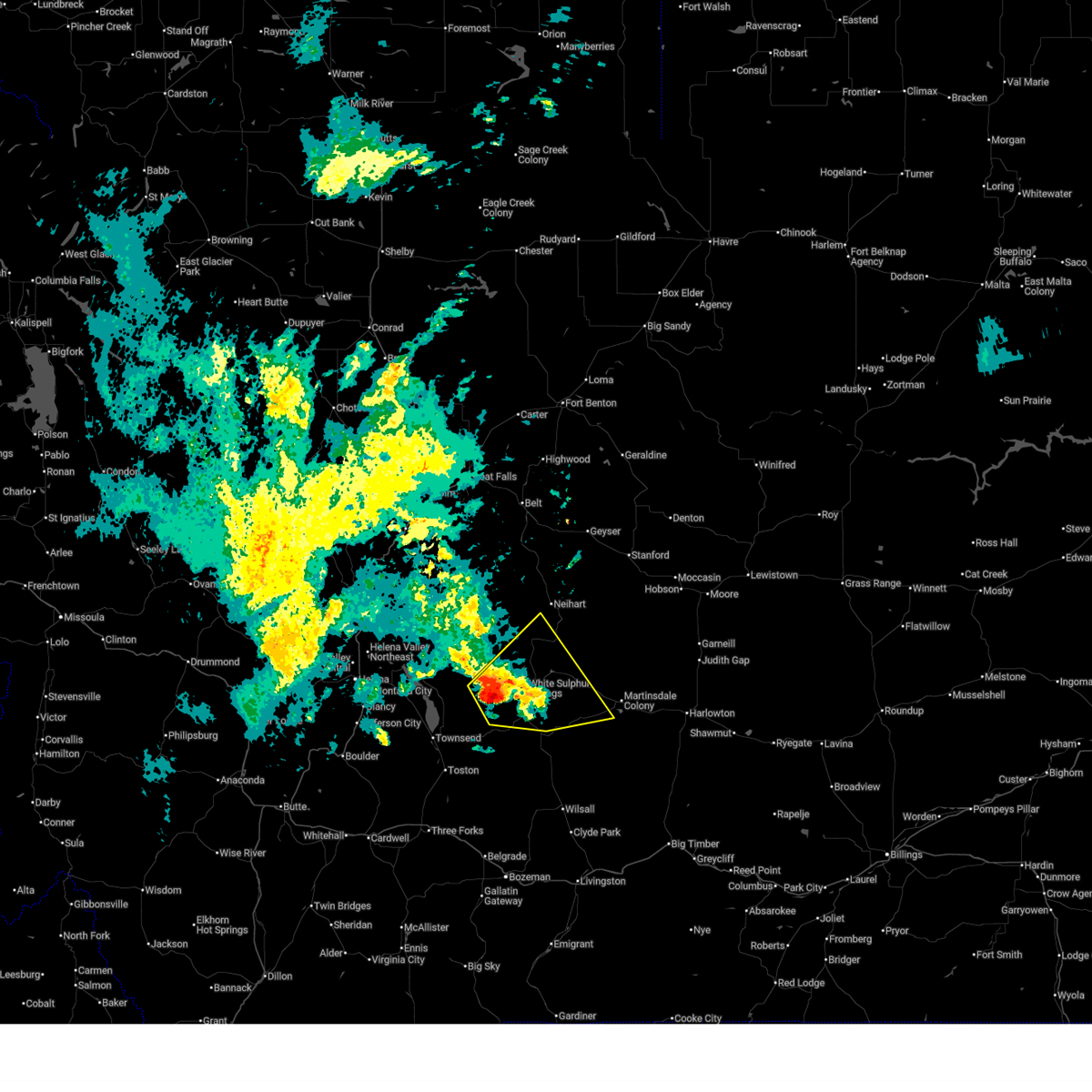 At 338 pm mdt, a severe thunderstorm was located 8 miles west of white sulphur springs, moving northeast at 40 mph (radar indicated). Hazards include 60 mph wind gusts and quarter size hail. Hail damage to vehicles is expected. expect wind damage to roofs, siding, and trees. Locations impacted include, white sulphur springs, checkerboard, newlan creek reservoir, and lennep. At 338 pm mdt, a severe thunderstorm was located 8 miles west of white sulphur springs, moving northeast at 40 mph (radar indicated). Hazards include 60 mph wind gusts and quarter size hail. Hail damage to vehicles is expected. expect wind damage to roofs, siding, and trees. Locations impacted include, white sulphur springs, checkerboard, newlan creek reservoir, and lennep.
|
| 6/20/2025 3:30 PM MDT |
 At 330 pm mdt, a severe thunderstorm was located 13 miles southwest of white sulphur springs, moving northeast at 40 mph (radar indicated). Hazards include 60 mph wind gusts and quarter size hail. Hail damage to vehicles is expected. expect wind damage to roofs, siding, and trees. Locations impacted include, white sulphur springs, checkerboard, newlan creek reservoir, and lennep. At 330 pm mdt, a severe thunderstorm was located 13 miles southwest of white sulphur springs, moving northeast at 40 mph (radar indicated). Hazards include 60 mph wind gusts and quarter size hail. Hail damage to vehicles is expected. expect wind damage to roofs, siding, and trees. Locations impacted include, white sulphur springs, checkerboard, newlan creek reservoir, and lennep.
|
| 6/20/2025 3:23 PM MDT |
 Svrtfx the national weather service in great falls has issued a * severe thunderstorm warning for, east central broadwater county in southwestern montana, central meagher county in central montana, * until 415 pm mdt. * at 323 pm mdt, a severe thunderstorm was located 13 miles northeast of townsend, moving northeast at 35 mph (radar indicated). Hazards include 60 mph wind gusts and quarter size hail. Hail damage to vehicles is expected. Expect wind damage to roofs, siding, and trees. Svrtfx the national weather service in great falls has issued a * severe thunderstorm warning for, east central broadwater county in southwestern montana, central meagher county in central montana, * until 415 pm mdt. * at 323 pm mdt, a severe thunderstorm was located 13 miles northeast of townsend, moving northeast at 35 mph (radar indicated). Hazards include 60 mph wind gusts and quarter size hail. Hail damage to vehicles is expected. Expect wind damage to roofs, siding, and trees.
|
| 6/19/2025 6:40 PM MDT | Mesonet station ncrm8 newlan creek raws. time of gust is estimated using radar given the site reports a peak gust once per hou in meagher county MT, 13.6 miles S of White Sulphur Springs, MT |
| 6/21/2024 2:03 PM MDT | Half Dollar sized hail reported 22.4 miles SSW of White Sulphur Springs, MT, hail up to half dollar size falling at showdown ski area. |
| 8/18/2023 3:50 PM MDT |
 At 349 pm mdt, severe thunderstorms were located along a line extending from 40 miles northeast of townsend to near white sulphur springs to 27 miles northeast of toston, moving east at 50 mph (radar indicated). Hazards include 60 mph wind gusts. expect damage to roofs, siding, and trees At 349 pm mdt, severe thunderstorms were located along a line extending from 40 miles northeast of townsend to near white sulphur springs to 27 miles northeast of toston, moving east at 50 mph (radar indicated). Hazards include 60 mph wind gusts. expect damage to roofs, siding, and trees
|
| 7/10/2023 5:43 PM MDT | Mesonet station mtdpc deep creek us12 mp 23. in meagher county MT, 15.8 miles NNE of White Sulphur Springs, MT |
| 7/1/2023 1:37 PM MDT |
 At 136 pm mdt, a severe thunderstorm was located 12 miles southwest of white sulphur springs, moving east at 40 mph (radar indicated). Hazards include 60 mph wind gusts. Expect damage to roofs, siding, and trees. locations impacted include, white sulphur springs. hail threat, radar indicated max hail size, <. 75 in wind threat, observed max wind gust, 60 mph. At 136 pm mdt, a severe thunderstorm was located 12 miles southwest of white sulphur springs, moving east at 40 mph (radar indicated). Hazards include 60 mph wind gusts. Expect damage to roofs, siding, and trees. locations impacted include, white sulphur springs. hail threat, radar indicated max hail size, <. 75 in wind threat, observed max wind gust, 60 mph.
|
| 7/1/2023 1:21 PM MDT |
 At 121 pm mdt, a severe thunderstorm was located 13 miles northeast of townsend, moving east at 50 mph (public observed wind near the silos). Hazards include 60 mph wind gusts. expect damage to roofs, siding, and trees At 121 pm mdt, a severe thunderstorm was located 13 miles northeast of townsend, moving east at 50 mph (public observed wind near the silos). Hazards include 60 mph wind gusts. expect damage to roofs, siding, and trees
|
| 7/1/2023 1:08 PM MDT |
 At 107 pm mdt, severe thunderstorms were located along a line extending from 24 miles south of cascade to 24 miles east of east helena to near townsend, moving east at 50 mph (public). Hazards include 60 mph wind gusts. Expect damage to roofs, siding, and trees. locations impacted include, white sulphur springs, silos, fort logan on the smith river, fort logan, winston and goose bay. hail threat, radar indicated max hail size, <. 75 in wind threat, observed max wind gust, 60 mph. At 107 pm mdt, severe thunderstorms were located along a line extending from 24 miles south of cascade to 24 miles east of east helena to near townsend, moving east at 50 mph (public). Hazards include 60 mph wind gusts. Expect damage to roofs, siding, and trees. locations impacted include, white sulphur springs, silos, fort logan on the smith river, fort logan, winston and goose bay. hail threat, radar indicated max hail size, <. 75 in wind threat, observed max wind gust, 60 mph.
|
| 7/1/2023 12:48 PM MDT |
 At 1247 pm mdt, severe thunderstorms were located along a line extending from 15 miles southeast of wolf creek to 9 miles east of east helena to 11 miles west of townsend, moving east at 50 mph (public). Hazards include 60 mph wind gusts. expect damage to roofs, siding, and trees At 1247 pm mdt, severe thunderstorms were located along a line extending from 15 miles southeast of wolf creek to 9 miles east of east helena to 11 miles west of townsend, moving east at 50 mph (public). Hazards include 60 mph wind gusts. expect damage to roofs, siding, and trees
|
| 9/7/2022 6:32 PM MDT |
 At 630 pm mdt, severe thunderstorms were located along a line extending from 16 miles north of black eagle to 19 miles southwest of geyser to near white sulphur springs, moving east at 40 mph (radar indicated). Hazards include 70 mph wind gusts, and widespread blowing dust. Expect considerable tree damage. damage is likely to mobile homes, roofs, and outbuildings. Visibility will be reduced to less than 2 miles at times in blowing dust. At 630 pm mdt, severe thunderstorms were located along a line extending from 16 miles north of black eagle to 19 miles southwest of geyser to near white sulphur springs, moving east at 40 mph (radar indicated). Hazards include 70 mph wind gusts, and widespread blowing dust. Expect considerable tree damage. damage is likely to mobile homes, roofs, and outbuildings. Visibility will be reduced to less than 2 miles at times in blowing dust.
|
| 9/7/2022 6:13 PM MDT |
 At 611 pm mdt, severe thunderstorms were located along a line extending from 9 miles east of dutton to 19 miles south of belt to near townsend, moving east at 50 mph (radar indicated). Hazards include 70 mph wind gusts, and blowing dust. Expect considerable tree damage. damage is likely to mobile homes, roofs, and outbuildings. visibility will be reduced to less than 2 miles at times in blowing dust. locations impacted include, great falls, townsend, fort benton, white sulphur springs, stanford, belt, dutton, highwood, black eagle, geyser, power, carter, neihart, fort logan on the smith river, floweree, eden, sapphire village, fort logan, stockett and first peoples buffalo jump state park. thunderstorm damage threat, considerable hail threat, radar indicated max hail size, <. 75 in wind threat, radar indicated max wind gust, 70 mph. At 611 pm mdt, severe thunderstorms were located along a line extending from 9 miles east of dutton to 19 miles south of belt to near townsend, moving east at 50 mph (radar indicated). Hazards include 70 mph wind gusts, and blowing dust. Expect considerable tree damage. damage is likely to mobile homes, roofs, and outbuildings. visibility will be reduced to less than 2 miles at times in blowing dust. locations impacted include, great falls, townsend, fort benton, white sulphur springs, stanford, belt, dutton, highwood, black eagle, geyser, power, carter, neihart, fort logan on the smith river, floweree, eden, sapphire village, fort logan, stockett and first peoples buffalo jump state park. thunderstorm damage threat, considerable hail threat, radar indicated max hail size, <. 75 in wind threat, radar indicated max wind gust, 70 mph.
|
| 9/7/2022 5:57 PM MDT |
 At 556 pm mdt, severe thunderstorms were located along a line extending from near dutton to 23 miles southeast of cascade to 10 miles southwest of townsend, moving east at 50 mph (radar indicated). Hazards include 70 mph wind gusts. Expect considerable tree damage. Damage is likely to mobile homes, roofs, and outbuildings. At 556 pm mdt, severe thunderstorms were located along a line extending from near dutton to 23 miles southeast of cascade to 10 miles southwest of townsend, moving east at 50 mph (radar indicated). Hazards include 70 mph wind gusts. Expect considerable tree damage. Damage is likely to mobile homes, roofs, and outbuildings.
|
| 8/4/2022 2:43 PM MDT |
 The severe thunderstorm warning for northeastern broadwater, meagher and northeastern gallatin counties will expire at 245 pm mdt, the storms which prompted the warning have weakened below severe limits, and no longer pose an immediate threat to life or property. therefore, the warning will be allowed to expire. however, wind gusts to 50 mph are still possible with these thunderstorms as they move across meagher county. The severe thunderstorm warning for northeastern broadwater, meagher and northeastern gallatin counties will expire at 245 pm mdt, the storms which prompted the warning have weakened below severe limits, and no longer pose an immediate threat to life or property. therefore, the warning will be allowed to expire. however, wind gusts to 50 mph are still possible with these thunderstorms as they move across meagher county.
|
| 8/4/2022 2:16 PM MDT |
 At 215 pm mdt, severe thunderstorms were located along a line extending from 15 miles north of townsend to 19 miles east of toston, moving east at 55 mph (radar indicated). Hazards include 60 mph wind gusts. expect damage to roofs, siding, and trees At 215 pm mdt, severe thunderstorms were located along a line extending from 15 miles north of townsend to 19 miles east of toston, moving east at 55 mph (radar indicated). Hazards include 60 mph wind gusts. expect damage to roofs, siding, and trees
|
| 7/6/2022 7:37 PM MDT |
 The severe thunderstorm warning for central meagher county will expire at 745 pm mdt, the storms which prompted the warning have weakened below severe limits, and no longer pose an immediate threat to life or property. therefore, the warning will be allowed to expire. a severe thunderstorm watch remains in effect until 1000 pm mdt for central montana. The severe thunderstorm warning for central meagher county will expire at 745 pm mdt, the storms which prompted the warning have weakened below severe limits, and no longer pose an immediate threat to life or property. therefore, the warning will be allowed to expire. a severe thunderstorm watch remains in effect until 1000 pm mdt for central montana.
|
| 7/6/2022 7:04 PM MDT |
 At 703 pm mdt, severe thunderstorms were located along a line extending from 35 miles northeast of townsend to 6 miles east of white sulphur springs, moving northeast at 25 mph (radar indicated). Hazards include 60 mph wind gusts and penny size hail. Expect damage to roofs, siding, and trees. locations impacted include, white sulphur springs, fort logan on the smith river, checkerboard, newlan creek reservoir and fort logan. hail threat, radar indicated max hail size, 0. 75 in wind threat, radar indicated max wind gust, 60 mph. At 703 pm mdt, severe thunderstorms were located along a line extending from 35 miles northeast of townsend to 6 miles east of white sulphur springs, moving northeast at 25 mph (radar indicated). Hazards include 60 mph wind gusts and penny size hail. Expect damage to roofs, siding, and trees. locations impacted include, white sulphur springs, fort logan on the smith river, checkerboard, newlan creek reservoir and fort logan. hail threat, radar indicated max hail size, 0. 75 in wind threat, radar indicated max wind gust, 60 mph.
|
| 7/6/2022 6:48 PM MDT |
 At 647 pm mdt, severe thunderstorms were located along a line extending from 25 miles northeast of east helena to 11 miles west of white sulphur springs, moving northeast at 20 mph (radar indicated). Hazards include 60 mph wind gusts and penny size hail. expect damage to roofs, siding, and trees At 647 pm mdt, severe thunderstorms were located along a line extending from 25 miles northeast of east helena to 11 miles west of white sulphur springs, moving northeast at 20 mph (radar indicated). Hazards include 60 mph wind gusts and penny size hail. expect damage to roofs, siding, and trees
|
| 8/20/2020 12:03 AM MDT | Mesonet station mtdpc deep creek us-12 (mt dot in meagher county MT, 15.8 miles NNE of White Sulphur Springs, MT |
| 7/23/2020 3:40 PM MDT | Part of a tree and a power line are in the street at the 200 block of central ave south of white sulphur springs. time was estimated based off of highest wind gust at t in meagher county MT, 0.2 miles S of White Sulphur Springs, MT |
| 7/7/2020 1:58 PM MDT |
 The severe thunderstorm warning for southeastern meagher county will expire at 200 pm mdt, this severe threat will be replaced with another severe thunderstorm warning. a severe thunderstorm watch remains in effect until 900 pm mdt for central montana. The severe thunderstorm warning for southeastern meagher county will expire at 200 pm mdt, this severe threat will be replaced with another severe thunderstorm warning. a severe thunderstorm watch remains in effect until 900 pm mdt for central montana.
|
| 7/7/2020 1:51 PM MDT |
 At 149 pm mdt, a severe thunderstorm was located 23 miles southeast of white sulphur springs, moving northeast at 50 mph (radar indicated). Hazards include 60 mph wind gusts and quarter size hail. Hail damage to vehicles is expected. expect wind damage to roofs, siding, and trees. Locations impacted include, white sulphur springs and lennep. At 149 pm mdt, a severe thunderstorm was located 23 miles southeast of white sulphur springs, moving northeast at 50 mph (radar indicated). Hazards include 60 mph wind gusts and quarter size hail. Hail damage to vehicles is expected. expect wind damage to roofs, siding, and trees. Locations impacted include, white sulphur springs and lennep.
|
| 7/7/2020 1:28 PM MDT |
 The national weather service in great falls has issued a * severe thunderstorm warning for. east central broadwater county in southwestern montana. southeastern meagher county in central montana. northeastern gallatin county in south central montana. Until 200 pm mdt. The national weather service in great falls has issued a * severe thunderstorm warning for. east central broadwater county in southwestern montana. southeastern meagher county in central montana. northeastern gallatin county in south central montana. Until 200 pm mdt.
|
| 7/3/2020 4:40 PM MDT | Mesonet station k7s6 3.6 s white sulphur springs (gtfwfo in meagher county MT, 3.3 miles N of White Sulphur Springs, MT |
| 8/10/2019 7:54 PM MDT |
 The severe thunderstorm warning for east central broadwater and southeastern meagher counties will expire at 800 pm mdt, the storm which prompted the warning has moved out of the area. therefore, the warning will be allowed to expire. a severe thunderstorm watch remains in effect until 900 pm mdt for south central, central and southwestern montana. remember, a new severe thunderstorm warning remains in effect for southern meagher county. The severe thunderstorm warning for east central broadwater and southeastern meagher counties will expire at 800 pm mdt, the storm which prompted the warning has moved out of the area. therefore, the warning will be allowed to expire. a severe thunderstorm watch remains in effect until 900 pm mdt for south central, central and southwestern montana. remember, a new severe thunderstorm warning remains in effect for southern meagher county.
|
| 8/10/2019 7:35 PM MDT |
 At 735 pm mdt, a severe thunderstorm was located 14 miles southwest of white sulphur springs, moving east at 40 mph (radar indicated). Hazards include ping pong ball size hail and 60 mph wind gusts. People and animals outdoors will be injured. expect hail damage to roofs, siding, windows, and vehicles. expect wind damage to roofs, siding, and trees. Locations impacted include, white sulphur springs, lennep and ringling. At 735 pm mdt, a severe thunderstorm was located 14 miles southwest of white sulphur springs, moving east at 40 mph (radar indicated). Hazards include ping pong ball size hail and 60 mph wind gusts. People and animals outdoors will be injured. expect hail damage to roofs, siding, windows, and vehicles. expect wind damage to roofs, siding, and trees. Locations impacted include, white sulphur springs, lennep and ringling.
|
| 8/10/2019 7:25 PM MDT |
 At 725 pm mdt, a severe thunderstorm was located 16 miles northeast of toston, or 17 miles east of townsend, moving east at 30 mph (radar indicated). Hazards include ping pong ball size hail and 60 mph wind gusts. People and animals outdoors will be injured. expect hail damage to roofs, siding, windows, and vehicles. expect wind damage to roofs, siding, and trees. Locations impacted include, white sulphur springs, lennep and ringling. At 725 pm mdt, a severe thunderstorm was located 16 miles northeast of toston, or 17 miles east of townsend, moving east at 30 mph (radar indicated). Hazards include ping pong ball size hail and 60 mph wind gusts. People and animals outdoors will be injured. expect hail damage to roofs, siding, windows, and vehicles. expect wind damage to roofs, siding, and trees. Locations impacted include, white sulphur springs, lennep and ringling.
|
| 8/10/2019 7:12 PM MDT |
 At 711 pm mdt, a severe thunderstorm was located 11 miles northeast of toston, or 14 miles east of townsend, moving east at 55 mph (radar indicated). Hazards include golf ball size hail and 60 mph wind gusts. People and animals outdoors will be injured. expect hail damage to roofs, siding, windows, and vehicles. Expect wind damage to roofs, siding, and trees. At 711 pm mdt, a severe thunderstorm was located 11 miles northeast of toston, or 14 miles east of townsend, moving east at 55 mph (radar indicated). Hazards include golf ball size hail and 60 mph wind gusts. People and animals outdoors will be injured. expect hail damage to roofs, siding, windows, and vehicles. Expect wind damage to roofs, siding, and trees.
|
| 7/14/2019 8:28 PM MDT |
 At 828 pm mdt, severe thunderstorms were located along a line extending from 18 miles east of east helena to 8 miles east of townsend, moving northeast at 35 mph (radar indicated). Hazards include 70 mph wind gusts and ping pong ball size hail. People and animals outdoors will be injured. expect hail damage to roofs, siding, windows, and vehicles. expect considerable tree damage. Wind damage is also likely to mobile homes, roofs, and outbuildings. At 828 pm mdt, severe thunderstorms were located along a line extending from 18 miles east of east helena to 8 miles east of townsend, moving northeast at 35 mph (radar indicated). Hazards include 70 mph wind gusts and ping pong ball size hail. People and animals outdoors will be injured. expect hail damage to roofs, siding, windows, and vehicles. expect considerable tree damage. Wind damage is also likely to mobile homes, roofs, and outbuildings.
|
| 7/6/2019 6:40 PM MDT |
 The severe thunderstorm warning for central meagher county will expire at 645 pm mdt, the storm which prompted the warning has weakened below severe limits, and no longer poses an immediate threat to life or property. therefore, the warning will be allowed to expire. however small hail, gusty winds and heavy rain are still possible with this thunderstorm. The severe thunderstorm warning for central meagher county will expire at 645 pm mdt, the storm which prompted the warning has weakened below severe limits, and no longer poses an immediate threat to life or property. therefore, the warning will be allowed to expire. however small hail, gusty winds and heavy rain are still possible with this thunderstorm.
|
| 7/6/2019 6:30 PM MDT | Ping Pong Ball sized hail reported 0.2 miles S of White Sulphur Springs, MT, spotter provided picture. hail was at least quarter-size. some stones looked to be as big as ping pong balls. |
| 7/6/2019 6:27 PM MDT |
 At 626 pm mdt, a severe thunderstorm was located over white sulphur springs, moving east at 10 mph (radar indicated). Hazards include 60 mph wind gusts and half dollar size hail. Hail damage to vehicles is expected. expect wind damage to roofs, siding, and trees. Locations impacted include, white sulphur springs and newlan creek reservoir. At 626 pm mdt, a severe thunderstorm was located over white sulphur springs, moving east at 10 mph (radar indicated). Hazards include 60 mph wind gusts and half dollar size hail. Hail damage to vehicles is expected. expect wind damage to roofs, siding, and trees. Locations impacted include, white sulphur springs and newlan creek reservoir.
|
| 7/6/2019 6:19 PM MDT | Half Dollar sized hail reported 0.2 miles S of White Sulphur Springs, MT, meagher county des coordinator reported quarter to half dollar-size hail. |
| 7/6/2019 6:13 PM MDT |
 The severe thunderstorm warning for central meagher county will expire at 615 pm mdt, a new warning has been issued just to the east of this warning. therefore, this warning will be allowed to expire at 6:15 pm. The severe thunderstorm warning for central meagher county will expire at 615 pm mdt, a new warning has been issued just to the east of this warning. therefore, this warning will be allowed to expire at 6:15 pm.
|
| 7/6/2019 6:10 PM MDT |
 At 609 pm mdt, a severe thunderstorm was located over white sulphur springs, moving east at 30 mph (radar indicated). Hazards include 60 mph wind gusts and half dollar size hail. Hail damage to vehicles is expected. Expect wind damage to roofs, siding, and trees. At 609 pm mdt, a severe thunderstorm was located over white sulphur springs, moving east at 30 mph (radar indicated). Hazards include 60 mph wind gusts and half dollar size hail. Hail damage to vehicles is expected. Expect wind damage to roofs, siding, and trees.
|
| 7/6/2019 5:38 PM MDT |
 At 538 pm mdt, a severe thunderstorm was located near white sulphur springs, moving east at 10 mph (radar indicated). Hazards include 60 mph wind gusts and half dollar size hail. Hail damage to vehicles is expected. Expect wind damage to roofs, siding, and trees. At 538 pm mdt, a severe thunderstorm was located near white sulphur springs, moving east at 10 mph (radar indicated). Hazards include 60 mph wind gusts and half dollar size hail. Hail damage to vehicles is expected. Expect wind damage to roofs, siding, and trees.
|
| 6/6/2019 3:25 PM MDT | Corrects previous non-tstm wnd gst report from 4 s white sulphur springs. mesonet station k7s6 white sulphur springs airpor in meagher county MT, 3.3 miles N of White Sulphur Springs, MT |
| 6/21/2018 4:20 PM MDT | White sulphur springs airport awos report from a collapsing thunderstor in meagher county MT, 3.3 miles N of White Sulphur Springs, MT |
| 10/1/2016 3:06 PM MDT | 62 mph wind gust at the dot sensor at deep creek pass on highway 1 in broadwater county MT, 15.8 miles NNE of White Sulphur Springs, MT |
| 8/7/2016 5:50 PM MDT |
 At 550 pm mdt, a severe thunderstorm was located near townsend, moving northeast at 25 mph. at 547 pm, the public reported half dollar size hail in townsend (public). Hazards include 60 mph wind gusts and half dollar size hail. Hail damage to vehicles is expected. expect wind damage to roofs, siding, and trees. Locations impacted include, townsend, white sulphur springs, fort logan on the smith river, lennep, silos, newlan creek reservoir and fort logan. At 550 pm mdt, a severe thunderstorm was located near townsend, moving northeast at 25 mph. at 547 pm, the public reported half dollar size hail in townsend (public). Hazards include 60 mph wind gusts and half dollar size hail. Hail damage to vehicles is expected. expect wind damage to roofs, siding, and trees. Locations impacted include, townsend, white sulphur springs, fort logan on the smith river, lennep, silos, newlan creek reservoir and fort logan.
|
| 8/7/2016 5:45 PM MDT |
 At 543 pm mdt, a severe thunderstorm was located near townsend, moving northeast at 40 mph. at 535 pm, trained spotters reported dime size hail in townsend. hail up to quarter size is likely (radar indicated). Hazards include 60 mph wind gusts and quarter size hail. Hail damage to vehicles is expected. Expect wind damage to roofs, siding, and trees. At 543 pm mdt, a severe thunderstorm was located near townsend, moving northeast at 40 mph. at 535 pm, trained spotters reported dime size hail in townsend. hail up to quarter size is likely (radar indicated). Hazards include 60 mph wind gusts and quarter size hail. Hail damage to vehicles is expected. Expect wind damage to roofs, siding, and trees.
|
| 6/1/2015 5:00 PM MDT | 64 mph wind gust at the deep creek raws location on highway 1 in meagher county MT, 14.9 miles NNE of White Sulphur Springs, MT |
| 6/1/2015 4:57 PM MDT | At 456 pm mdt, doppler radar indicated a severe thunderstorm capable of producing quarter size hail and damaging winds in excess of 60 mph. this storm was located 18 miles south of white sulphur springs, and moving northeast at 30 mph. |
| 7/8/2013 2:00 PM MDT | Quarter sized hail reported 8.1 miles E of White Sulphur Springs, MT |
| 8/14/2012 9:45 PM MDT | Wind gust estimated near 60 mph. power was out for about 3 hour in meagher county MT, 0.2 miles S of White Sulphur Springs, MT |
| 6/5/2012 4:17 PM MDT | Hen Egg sized hail reported 0.5 miles N of White Sulphur Springs, MT, hail measued at 2.0 inches |
| 6/5/2012 3:50 PM MDT | Quarter sized hail reported 0.2 miles S of White Sulphur Springs, MT |
| 6/5/2012 3:44 PM MDT | Golf Ball sized hail reported 0.2 miles S of White Sulphur Springs, MT, sheriff office reports golf ball size hail in white sulphur springs falling at the sheriff office. |
Hail Maps for White Sulphur Springs, MT


Connect with Interactive Hail Maps