

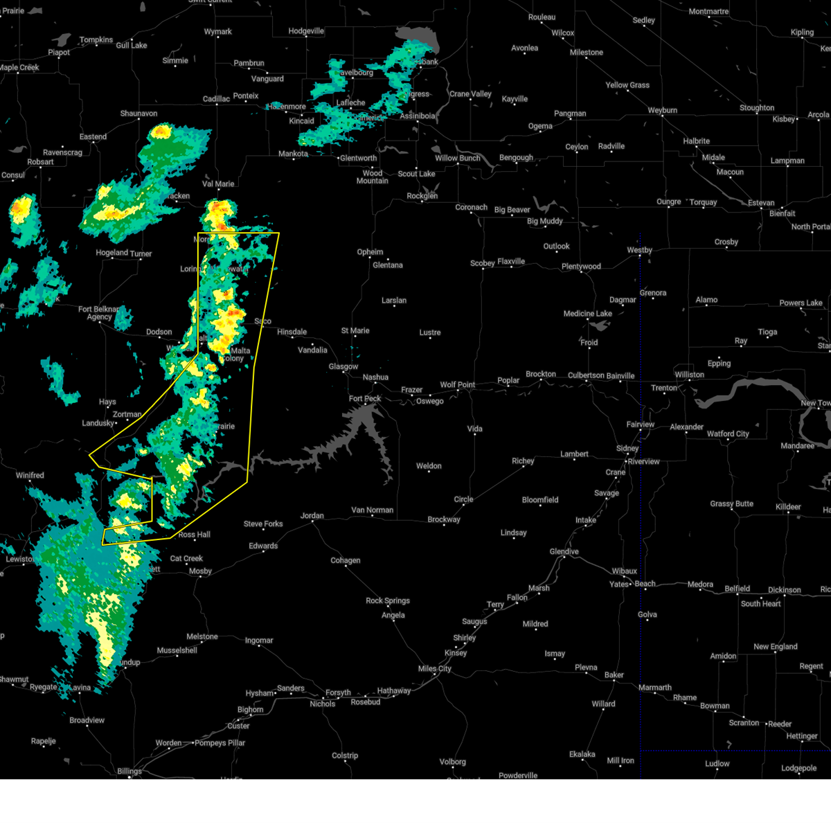
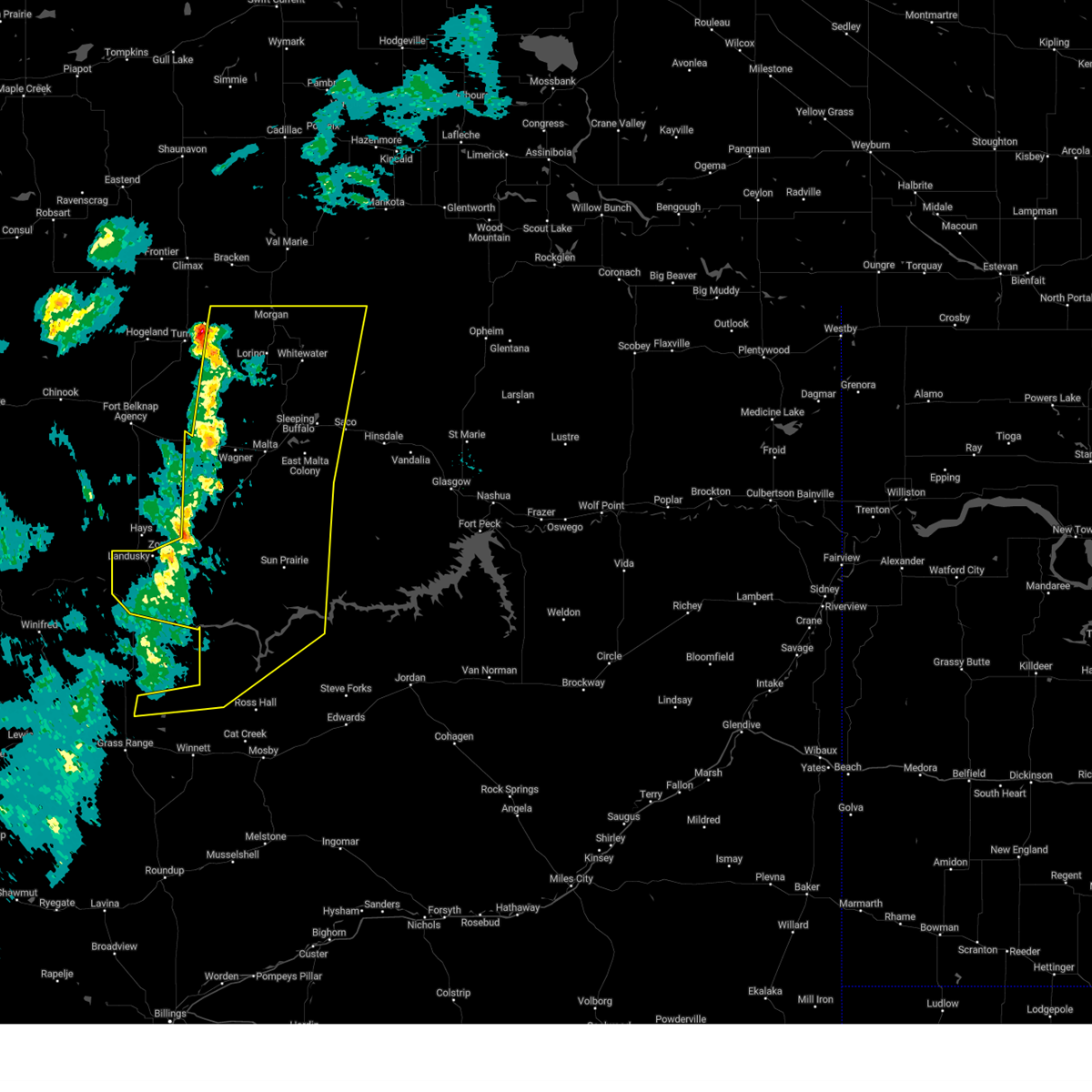
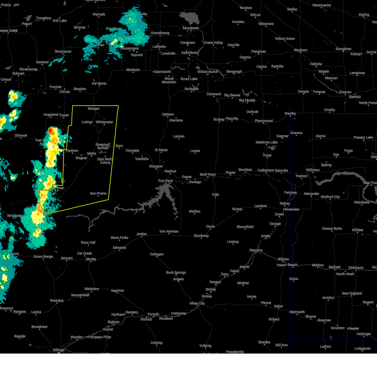
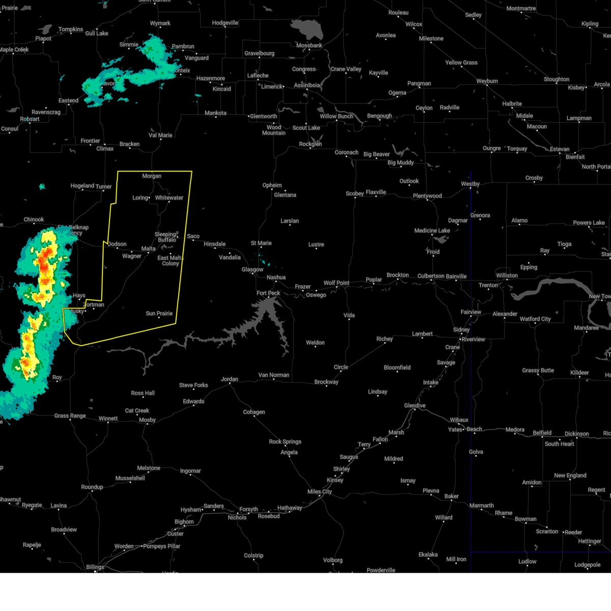
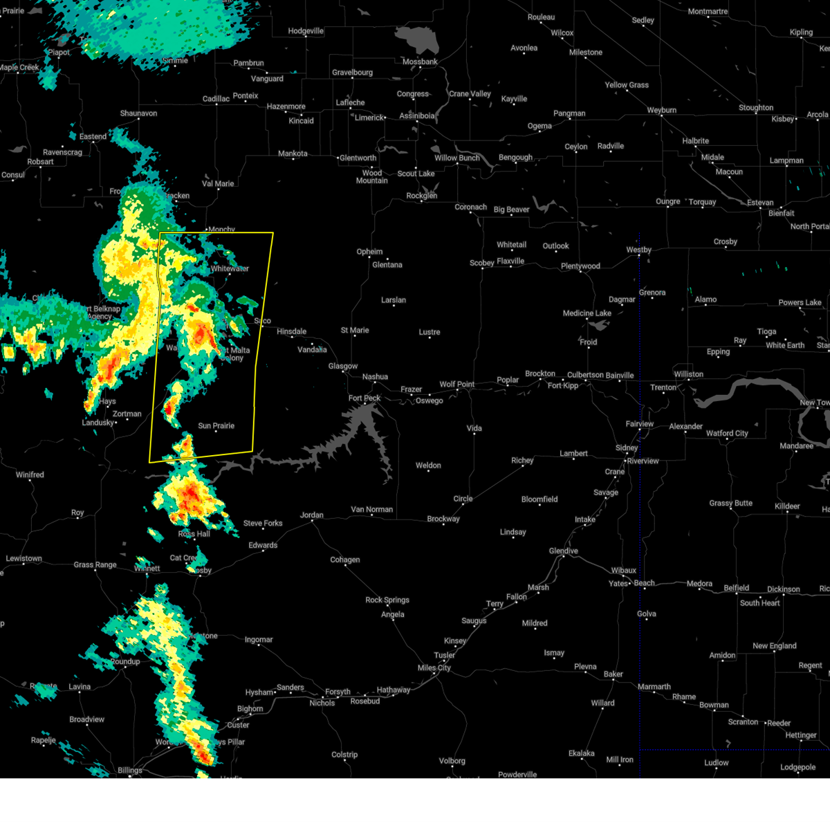
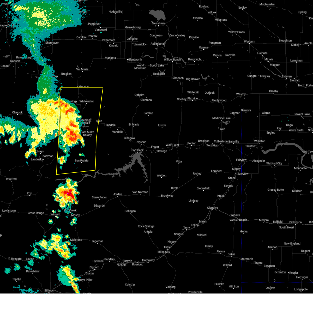
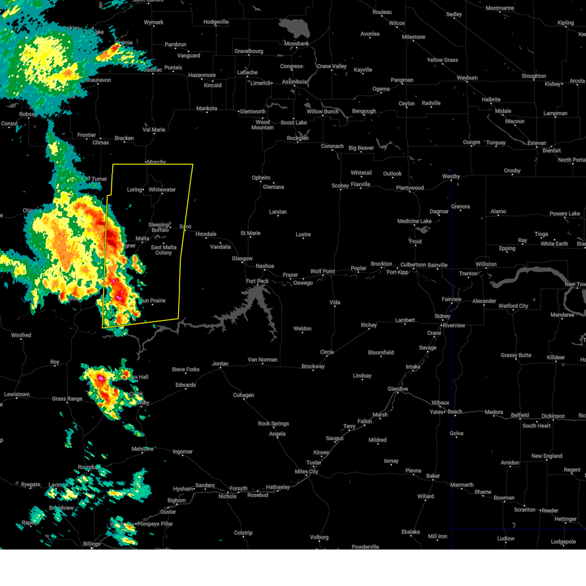
Hail Map for Whitewater, MT
The Whitewater, MT area has had 3 reports of on-the-ground hail by trained spotters, and has been under severe weather warnings 7 times during the past 12 months. Doppler radar has detected hail at or near Whitewater, MT on 17 occasions, including 1 occasion during the past year.
| Name: | Whitewater, MT |
| Where Located: | 60.1 miles NW of Glasgow, MT |
| Map: | Google Map for Whitewater, MT |
| Population: | 64 |
| Housing Units: | 38 |
| More Info: | Search Google for Whitewater, MT |
1
The Top Recent Hail Date for Whitewater, MT is Friday, August 23, 2024 (3rd out of 17)

Hail and Wind Damage Spotted near Whitewater, MT
| Date / Time | Report Details |
|---|---|
| 5/10/2025 7:39 PM MDT |
 At 738 pm mdt, severe thunderstorms were located along a line extending from 16 miles east of port of morgan to 15 miles south of crooked creek rec area, moving east at 45 mph (public). Hazards include 60 mph wind gusts. Expect damage to roofs, siding, and trees. Locations impacted include, fourchette, u l bend rec area, sleeping buffalo, fred robinson bridge, crooked creek rec area, whitewater, phillips, malta, loring, devils creek rec area, port of morgan, content, sun prairie, and bowdoin. At 738 pm mdt, severe thunderstorms were located along a line extending from 16 miles east of port of morgan to 15 miles south of crooked creek rec area, moving east at 45 mph (public). Hazards include 60 mph wind gusts. Expect damage to roofs, siding, and trees. Locations impacted include, fourchette, u l bend rec area, sleeping buffalo, fred robinson bridge, crooked creek rec area, whitewater, phillips, malta, loring, devils creek rec area, port of morgan, content, sun prairie, and bowdoin.
|
| 5/10/2025 7:15 PM MDT | Loring sw (hydromet) in north-central phillips count in phillips county MT, 11.4 miles E of Whitewater, MT |
| 5/10/2025 6:57 PM MDT |
 Svrggw the national weather service in glasgow has issued a * severe thunderstorm warning for, phillips county in northeastern montana, northern petroleum county in northeastern montana, west central garfield county in northeastern montana, * until 800 pm mdt. * at 656 pm mdt, severe thunderstorms were located along a line extending from near loring to 16 miles north of winnett, moving northeast at 40 mph (radar indicated). Hazards include 60 mph wind gusts. expect damage to roofs, siding, and trees Svrggw the national weather service in glasgow has issued a * severe thunderstorm warning for, phillips county in northeastern montana, northern petroleum county in northeastern montana, west central garfield county in northeastern montana, * until 800 pm mdt. * at 656 pm mdt, severe thunderstorms were located along a line extending from near loring to 16 miles north of winnett, moving northeast at 40 mph (radar indicated). Hazards include 60 mph wind gusts. expect damage to roofs, siding, and trees
|
| 5/10/2025 6:30 PM MDT |
 At 630 pm mdt, severe thunderstorms were located along a line extending from 7 miles southeast of turner to 17 miles south of zortman, moving northeast at 40 mph (radar indicated). Hazards include 60 mph wind gusts. Expect damage to roofs, siding, and trees. Locations impacted include, chapman, sleeping buffalo, wagner, fred robinson bridge, whitewater, phillips, dodson, malta, loring, port of morgan, zortman, landusky, content, sun prairie, bowdoin, and fourchette. At 630 pm mdt, severe thunderstorms were located along a line extending from 7 miles southeast of turner to 17 miles south of zortman, moving northeast at 40 mph (radar indicated). Hazards include 60 mph wind gusts. Expect damage to roofs, siding, and trees. Locations impacted include, chapman, sleeping buffalo, wagner, fred robinson bridge, whitewater, phillips, dodson, malta, loring, port of morgan, zortman, landusky, content, sun prairie, bowdoin, and fourchette.
|
| 5/10/2025 5:59 PM MDT |
 Svrggw the national weather service in glasgow has issued a * severe thunderstorm warning for, phillips county in northeastern montana, * until 700 pm mdt. * at 559 pm mdt, severe thunderstorms were located along a line extending from 10 miles west of turner to near zortman, moving northeast at 60 mph (radar indicated). Hazards include 60 mph wind gusts. expect damage to roofs, siding, and trees Svrggw the national weather service in glasgow has issued a * severe thunderstorm warning for, phillips county in northeastern montana, * until 700 pm mdt. * at 559 pm mdt, severe thunderstorms were located along a line extending from 10 miles west of turner to near zortman, moving northeast at 60 mph (radar indicated). Hazards include 60 mph wind gusts. expect damage to roofs, siding, and trees
|
| 8/19/2024 4:22 AM MDT |
 The storms which prompted the warning have weakened below severe limits, and no longer pose an immediate threat to life or property. therefore, the warning will be allowed to expire. however, gusty winds and heavy rain are still possible with these thunderstorms. The storms which prompted the warning have weakened below severe limits, and no longer pose an immediate threat to life or property. therefore, the warning will be allowed to expire. however, gusty winds and heavy rain are still possible with these thunderstorms.
|
| 8/19/2024 4:03 AM MDT |
 At 403 am mdt, severe thunderstorms were located along a line extending from 6 miles south of port of morgan to 23 miles southeast of malta, moving northeast at 30 mph (radar indicated). Hazards include 60 mph wind gusts and quarter size hail. Hail damage to vehicles is expected. expect wind damage to roofs, siding, and trees. Locations impacted include, malta, whitewater, dodson, fourchette, loring, port of morgan, phillips, chapman, sleeping buffalo, wagner, content, sun prairie, and bowdoin. At 403 am mdt, severe thunderstorms were located along a line extending from 6 miles south of port of morgan to 23 miles southeast of malta, moving northeast at 30 mph (radar indicated). Hazards include 60 mph wind gusts and quarter size hail. Hail damage to vehicles is expected. expect wind damage to roofs, siding, and trees. Locations impacted include, malta, whitewater, dodson, fourchette, loring, port of morgan, phillips, chapman, sleeping buffalo, wagner, content, sun prairie, and bowdoin.
|
| 8/19/2024 3:24 AM MDT |
 Svrggw the national weather service in glasgow has issued a * severe thunderstorm warning for, phillips county in northeastern montana, * until 430 am mdt. * at 323 am mdt, severe thunderstorms were located along a line extending from 13 miles southeast of turner to 7 miles northeast of fourchette, moving northeast at 40 mph (radar indicated). Hazards include 60 mph wind gusts and quarter size hail. Hail damage to vehicles is expected. Expect wind damage to roofs, siding, and trees. Svrggw the national weather service in glasgow has issued a * severe thunderstorm warning for, phillips county in northeastern montana, * until 430 am mdt. * at 323 am mdt, severe thunderstorms were located along a line extending from 13 miles southeast of turner to 7 miles northeast of fourchette, moving northeast at 40 mph (radar indicated). Hazards include 60 mph wind gusts and quarter size hail. Hail damage to vehicles is expected. Expect wind damage to roofs, siding, and trees.
|
| 6/6/2023 3:51 PM MDT |
 The severe thunderstorm warning for northeastern phillips and northwestern valley counties will expire at 400 pm mdt, the storm which prompted the warning has weakened below severe limits, and no longer poses an immediate threat to life or property. therefore, the warning will be allowed to expire. however gusty winds and heavy rain are still possible with this thunderstorm. The severe thunderstorm warning for northeastern phillips and northwestern valley counties will expire at 400 pm mdt, the storm which prompted the warning has weakened below severe limits, and no longer poses an immediate threat to life or property. therefore, the warning will be allowed to expire. however gusty winds and heavy rain are still possible with this thunderstorm.
|
| 6/6/2023 3:25 PM MDT |
 At 324 pm mdt, a severe thunderstorm was located 7 miles east of whitewater, moving east at 15 mph (trained weather spotters). Hazards include 60 mph wind gusts and quarter size hail. Hail damage to vehicles is expected. expect wind damage to roofs, siding, and trees. locations impacted include, whitewater, saco, frenchman reservoir and sleeping buffalo. hail threat, radar indicated max hail size, 1. 00 in wind threat, radar indicated max wind gust, 60 mph. At 324 pm mdt, a severe thunderstorm was located 7 miles east of whitewater, moving east at 15 mph (trained weather spotters). Hazards include 60 mph wind gusts and quarter size hail. Hail damage to vehicles is expected. expect wind damage to roofs, siding, and trees. locations impacted include, whitewater, saco, frenchman reservoir and sleeping buffalo. hail threat, radar indicated max hail size, 1. 00 in wind threat, radar indicated max wind gust, 60 mph.
|
| 6/6/2023 2:55 PM MDT |
 At 254 pm mdt, a severe thunderstorm was located over whitewater, moving east at 15 mph (radar indicated). Hazards include ping pong ball size hail and 60 mph wind gusts. People and animals outdoors will be injured. expect hail damage to roofs, siding, windows, and vehicles. Expect wind damage to roofs, siding, and trees. At 254 pm mdt, a severe thunderstorm was located over whitewater, moving east at 15 mph (radar indicated). Hazards include ping pong ball size hail and 60 mph wind gusts. People and animals outdoors will be injured. expect hail damage to roofs, siding, windows, and vehicles. Expect wind damage to roofs, siding, and trees.
|
| 6/6/2023 2:50 PM MDT | Quarter sized hail reported 0.1 miles NW of Whitewater, MT, also reported heavy rain... 35 mph wind gusts estimated. |
| 6/6/2023 2:31 PM MDT |
 At 230 pm mdt, a severe thunderstorm was located 7 miles southwest of whitewater, moving east at 15 mph (radar indicated). Hazards include 60 mph wind gusts and quarter size hail. Hail damage to vehicles is expected. expect wind damage to roofs, siding, and trees. locations impacted include, whitewater, loring, port of morgan, chapman and sleeping buffalo. hail threat, radar indicated max hail size, 1. 00 in wind threat, radar indicated max wind gust, 60 mph. At 230 pm mdt, a severe thunderstorm was located 7 miles southwest of whitewater, moving east at 15 mph (radar indicated). Hazards include 60 mph wind gusts and quarter size hail. Hail damage to vehicles is expected. expect wind damage to roofs, siding, and trees. locations impacted include, whitewater, loring, port of morgan, chapman and sleeping buffalo. hail threat, radar indicated max hail size, 1. 00 in wind threat, radar indicated max wind gust, 60 mph.
|
| 6/6/2023 2:07 PM MDT |
 At 207 pm mdt, a severe thunderstorm was located 8 miles south of loring, or 14 miles southwest of whitewater, moving east at 15 mph (radar indicated). Hazards include ping pong ball size hail and 60 mph wind gusts. People and animals outdoors will be injured. expect hail damage to roofs, siding, windows, and vehicles. Expect wind damage to roofs, siding, and trees. At 207 pm mdt, a severe thunderstorm was located 8 miles south of loring, or 14 miles southwest of whitewater, moving east at 15 mph (radar indicated). Hazards include ping pong ball size hail and 60 mph wind gusts. People and animals outdoors will be injured. expect hail damage to roofs, siding, windows, and vehicles. Expect wind damage to roofs, siding, and trees.
|
| 5/24/2023 4:05 PM MDT |
 At 405 pm mdt, a severe thunderstorm was located near whitewater, moving north at 15 mph (radar indicated). Hazards include ping pong ball size hail and 60 mph wind gusts. People and animals outdoors will be injured. expect hail damage to roofs, siding, windows, and vehicles. expect wind damage to roofs, siding, and trees. locations impacted include, whitewater. hail threat, radar indicated max hail size, 1. 50 in wind threat, radar indicated max wind gust, 60 mph. At 405 pm mdt, a severe thunderstorm was located near whitewater, moving north at 15 mph (radar indicated). Hazards include ping pong ball size hail and 60 mph wind gusts. People and animals outdoors will be injured. expect hail damage to roofs, siding, windows, and vehicles. expect wind damage to roofs, siding, and trees. locations impacted include, whitewater. hail threat, radar indicated max hail size, 1. 50 in wind threat, radar indicated max wind gust, 60 mph.
|
| 5/24/2023 3:36 PM MDT |
 At 336 pm mdt, a severe thunderstorm was located 13 miles south of whitewater, moving north at 15 mph (radar indicated). Hazards include 60 mph wind gusts and quarter size hail. Hail damage to vehicles is expected. Expect wind damage to roofs, siding, and trees. At 336 pm mdt, a severe thunderstorm was located 13 miles south of whitewater, moving north at 15 mph (radar indicated). Hazards include 60 mph wind gusts and quarter size hail. Hail damage to vehicles is expected. Expect wind damage to roofs, siding, and trees.
|
| 8/12/2022 6:26 PM MDT |
 The severe thunderstorm warning for northeastern phillips county will expire at 630 pm mdt, the storm which prompted the warning has weakened below severe limits, and has exited the warned area. therefore, the warning will be allowed to expire. however gusty winds are still possible with this thunderstorm. The severe thunderstorm warning for northeastern phillips county will expire at 630 pm mdt, the storm which prompted the warning has weakened below severe limits, and has exited the warned area. therefore, the warning will be allowed to expire. however gusty winds are still possible with this thunderstorm.
|
| 8/12/2022 6:06 PM MDT |
 At 605 pm mdt, a severe thunderstorm was located near whitewater, moving southeast at 25 mph (radar indicated). Hazards include 60 mph wind gusts and quarter size hail. Hail damage to vehicles is expected. expect wind damage to roofs, siding, and trees. locations impacted include, whitewater and port of morgan. hail threat, radar indicated max hail size, 1. 00 in wind threat, radar indicated max wind gust, 60 mph. At 605 pm mdt, a severe thunderstorm was located near whitewater, moving southeast at 25 mph (radar indicated). Hazards include 60 mph wind gusts and quarter size hail. Hail damage to vehicles is expected. expect wind damage to roofs, siding, and trees. locations impacted include, whitewater and port of morgan. hail threat, radar indicated max hail size, 1. 00 in wind threat, radar indicated max wind gust, 60 mph.
|
| 8/12/2022 5:27 PM MDT |
 At 526 pm mdt, a severe thunderstorm was located over port of morgan, or 20 miles northwest of whitewater, moving southeast at 25 mph (radar indicated). Hazards include 60 mph wind gusts and quarter size hail. Hail damage to vehicles is expected. Expect wind damage to roofs, siding, and trees. At 526 pm mdt, a severe thunderstorm was located over port of morgan, or 20 miles northwest of whitewater, moving southeast at 25 mph (radar indicated). Hazards include 60 mph wind gusts and quarter size hail. Hail damage to vehicles is expected. Expect wind damage to roofs, siding, and trees.
|
| 7/18/2022 4:01 PM MDT |
 At 400 pm mdt, a severe thunderstorm was located 12 miles southeast of dodson, or 14 miles southwest of malta, moving northeast at 55 mph (radar indicated). Hazards include 60 mph wind gusts and nickel size hail. expect damage to roofs, siding, and trees At 400 pm mdt, a severe thunderstorm was located 12 miles southeast of dodson, or 14 miles southwest of malta, moving northeast at 55 mph (radar indicated). Hazards include 60 mph wind gusts and nickel size hail. expect damage to roofs, siding, and trees
|
| 7/9/2022 7:53 PM MDT |
 At 753 pm mdt, severe thunderstorms were located along a line extending from 20 miles northeast of chinook to near harlem to 17 miles south of fort belknap, moving east at 45 mph (radar indicated). Hazards include 60 mph wind gusts and quarter size hail. Hail damage to vehicles is expected. Expect wind damage to roofs, siding, and trees. At 753 pm mdt, severe thunderstorms were located along a line extending from 20 miles northeast of chinook to near harlem to 17 miles south of fort belknap, moving east at 45 mph (radar indicated). Hazards include 60 mph wind gusts and quarter size hail. Hail damage to vehicles is expected. Expect wind damage to roofs, siding, and trees.
|
| 7/8/2022 10:12 PM MDT |
 The severe thunderstorm warning for northeastern phillips and northwestern valley counties will expire at 1015 pm mdt, the storm which prompted the warning has weakened below severe limits, and no longer poses an immediate threat to life or property. therefore, the warning will be allowed to expire. however gusty winds are still possible with this thunderstorm. a severe thunderstorm watch remains in effect until 300 am mdt for northeastern montana. The severe thunderstorm warning for northeastern phillips and northwestern valley counties will expire at 1015 pm mdt, the storm which prompted the warning has weakened below severe limits, and no longer poses an immediate threat to life or property. therefore, the warning will be allowed to expire. however gusty winds are still possible with this thunderstorm. a severe thunderstorm watch remains in effect until 300 am mdt for northeastern montana.
|
| 7/8/2022 9:15 PM MDT |
 At 914 pm mdt, a severe thunderstorm was located 8 miles northwest of dodson, or 24 miles northwest of malta, moving east at 50 mph. this is a destructive storm for dodson and surrounding areas (radar indicated). Hazards include 80 mph wind gusts and nickel size hail. Flying debris will be dangerous to those caught without shelter. mobile homes will be heavily damaged. expect considerable damage to roofs, windows, and vehicles. Extensive tree damage and power outages are likely. At 914 pm mdt, a severe thunderstorm was located 8 miles northwest of dodson, or 24 miles northwest of malta, moving east at 50 mph. this is a destructive storm for dodson and surrounding areas (radar indicated). Hazards include 80 mph wind gusts and nickel size hail. Flying debris will be dangerous to those caught without shelter. mobile homes will be heavily damaged. expect considerable damage to roofs, windows, and vehicles. Extensive tree damage and power outages are likely.
|
| 7/8/2021 1:41 PM MDT |
 At 141 pm mdt, a severe thunderstorm was located near whitewater, moving southeast at 25 mph (radar indicated). Hazards include 60 mph wind gusts and quarter size hail. Hail damage to vehicles is expected. expect wind damage to roofs, siding, and trees. Locations impacted include, whitewater and frenchman reservoir. At 141 pm mdt, a severe thunderstorm was located near whitewater, moving southeast at 25 mph (radar indicated). Hazards include 60 mph wind gusts and quarter size hail. Hail damage to vehicles is expected. expect wind damage to roofs, siding, and trees. Locations impacted include, whitewater and frenchman reservoir.
|
| 7/8/2021 1:15 PM MDT |
 At 115 pm mdt, a severe thunderstorm was located 7 miles south of port of morgan, or 11 miles northwest of whitewater, moving east at 25 mph (radar indicated). Hazards include 60 mph wind gusts and penny size hail. expect damage to roofs, siding, and trees At 115 pm mdt, a severe thunderstorm was located 7 miles south of port of morgan, or 11 miles northwest of whitewater, moving east at 25 mph (radar indicated). Hazards include 60 mph wind gusts and penny size hail. expect damage to roofs, siding, and trees
|
| 6/8/2021 7:25 PM MDT |
 The severe thunderstorm warning for northeastern phillips and northwestern valley counties will expire at 730 pm mdt, the storm which prompted the warning has weakened below severe limits, and no longer poses an immediate threat to life or property. therefore, the warning will be allowed to expire. a severe thunderstorm watch remains in effect until 1100 pm mdt for northeastern montana. The severe thunderstorm warning for northeastern phillips and northwestern valley counties will expire at 730 pm mdt, the storm which prompted the warning has weakened below severe limits, and no longer poses an immediate threat to life or property. therefore, the warning will be allowed to expire. a severe thunderstorm watch remains in effect until 1100 pm mdt for northeastern montana.
|
| 6/8/2021 7:06 PM MDT |
 At 705 pm mdt, a severe thunderstorm was located 10 miles east of whitewater, moving north at 50 mph (radar indicated). Hazards include 60 mph wind gusts and quarter size hail. Hail damage to vehicles is expected. Expect wind damage to roofs, siding, and trees. At 705 pm mdt, a severe thunderstorm was located 10 miles east of whitewater, moving north at 50 mph (radar indicated). Hazards include 60 mph wind gusts and quarter size hail. Hail damage to vehicles is expected. Expect wind damage to roofs, siding, and trees.
|
| 6/8/2021 6:43 PM MDT |
 At 642 pm mdt, a severe thunderstorm was located 11 miles southeast of whitewater, moving north at 45 mph (radar indicated). Hazards include 60 mph wind gusts and quarter size hail. Hail damage to vehicles is expected. expect wind damage to roofs, siding, and trees. Locations impacted include, whitewater, saco, loring, frenchman reservoir and sleeping buffalo. At 642 pm mdt, a severe thunderstorm was located 11 miles southeast of whitewater, moving north at 45 mph (radar indicated). Hazards include 60 mph wind gusts and quarter size hail. Hail damage to vehicles is expected. expect wind damage to roofs, siding, and trees. Locations impacted include, whitewater, saco, loring, frenchman reservoir and sleeping buffalo.
|
| 6/8/2021 6:16 PM MDT |
 At 615 pm mdt, a severe thunderstorm was located 13 miles southwest of hinsdale, or 28 miles west of glasgow, moving north at 45 mph (radar indicated). Hazards include 60 mph wind gusts and quarter size hail. Hail damage to vehicles is expected. Expect wind damage to roofs, siding, and trees. At 615 pm mdt, a severe thunderstorm was located 13 miles southwest of hinsdale, or 28 miles west of glasgow, moving north at 45 mph (radar indicated). Hazards include 60 mph wind gusts and quarter size hail. Hail damage to vehicles is expected. Expect wind damage to roofs, siding, and trees.
|
| 7/7/2020 5:12 PM MDT |
 At 511 pm mdt, severe thunderstorms were located along a line extending from 14 miles west of port of morgan to 11 miles northwest of saco to 12 miles southwest of hinsdale, moving east at 60 mph. these are very dangerous storms (awos mesonet). Hazards include 90 mph wind gusts and half dollar size hail. You are in a life-threatening situation. flying debris may be deadly to those caught without shelter. mobile homes will be heavily damaged or destroyed. homes and businesses will have substantial roof and window damage. Expect extensive tree damage and power outages. At 511 pm mdt, severe thunderstorms were located along a line extending from 14 miles west of port of morgan to 11 miles northwest of saco to 12 miles southwest of hinsdale, moving east at 60 mph. these are very dangerous storms (awos mesonet). Hazards include 90 mph wind gusts and half dollar size hail. You are in a life-threatening situation. flying debris may be deadly to those caught without shelter. mobile homes will be heavily damaged or destroyed. homes and businesses will have substantial roof and window damage. Expect extensive tree damage and power outages.
|
| 6/27/2019 8:15 PM MDT |
 At 815 pm mdt, severe thunderstorms were located along a line extending from near port of morgan to 23 miles southeast of malta, moving northeast at 40 mph (radar indicated). Hazards include 60 mph wind gusts. Expect damage to roofs, siding, and trees. Locations impacted include, whitewater, saco, fourchette, sleeping buffalo, content, sun prairie, frenchman reservoir and bowdoin. At 815 pm mdt, severe thunderstorms were located along a line extending from near port of morgan to 23 miles southeast of malta, moving northeast at 40 mph (radar indicated). Hazards include 60 mph wind gusts. Expect damage to roofs, siding, and trees. Locations impacted include, whitewater, saco, fourchette, sleeping buffalo, content, sun prairie, frenchman reservoir and bowdoin.
|
| 6/27/2019 7:37 PM MDT |
 At 737 pm mdt, severe thunderstorms were located along a line extending from 6 miles northeast of turner to 14 miles northwest of fourchette, moving northeast at 40 mph. these are very dangerous storms (radar indicated). Hazards include 80 mph wind gusts. Flying debris will be dangerous to those caught without shelter. mobile homes will be heavily damaged. expect considerable damage to roofs, windows, and vehicles. Extensive tree damage and power outages are likely. At 737 pm mdt, severe thunderstorms were located along a line extending from 6 miles northeast of turner to 14 miles northwest of fourchette, moving northeast at 40 mph. these are very dangerous storms (radar indicated). Hazards include 80 mph wind gusts. Flying debris will be dangerous to those caught without shelter. mobile homes will be heavily damaged. expect considerable damage to roofs, windows, and vehicles. Extensive tree damage and power outages are likely.
|
| 7/10/2018 5:36 PM MDT |
 The severe thunderstorm warning for northeastern phillips county will expire at 545 pm mdt, the storm which prompted the warning has moved out of the area. therefore, the warning will be allowed to expire. however gusty winds are still possible with this thunderstorm. a severe thunderstorm watch remains in effect until 900 pm mdt for northeastern montana. The severe thunderstorm warning for northeastern phillips county will expire at 545 pm mdt, the storm which prompted the warning has moved out of the area. therefore, the warning will be allowed to expire. however gusty winds are still possible with this thunderstorm. a severe thunderstorm watch remains in effect until 900 pm mdt for northeastern montana.
|
| 7/10/2018 5:20 PM MDT |
 At 520 pm mdt, a severe thunderstorm was located over port of morgan, or 17 miles northwest of whitewater, moving northeast at 45 mph (radar indicated). Hazards include 60 mph wind gusts and quarter size hail. Hail damage to vehicles is expected. expect wind damage to roofs, siding, and trees. Locations impacted include, whitewater, loring and port of morgan. At 520 pm mdt, a severe thunderstorm was located over port of morgan, or 17 miles northwest of whitewater, moving northeast at 45 mph (radar indicated). Hazards include 60 mph wind gusts and quarter size hail. Hail damage to vehicles is expected. expect wind damage to roofs, siding, and trees. Locations impacted include, whitewater, loring and port of morgan.
|
| 7/10/2018 4:46 PM MDT |
 At 446 pm mdt, a severe thunderstorm was located near turner, or 31 miles west of whitewater, moving northeast at 45 mph (radar indicated). Hazards include ping pong ball size hail and 60 mph wind gusts. People and animals outdoors will be injured. expect hail damage to roofs, siding, windows, and vehicles. Expect wind damage to roofs, siding, and trees. At 446 pm mdt, a severe thunderstorm was located near turner, or 31 miles west of whitewater, moving northeast at 45 mph (radar indicated). Hazards include ping pong ball size hail and 60 mph wind gusts. People and animals outdoors will be injured. expect hail damage to roofs, siding, windows, and vehicles. Expect wind damage to roofs, siding, and trees.
|
| 7/30/2016 6:20 PM MDT | Tree limbs down in phillips county MT, 17.4 miles SSW of Whitewater, MT |
| 7/30/2016 6:06 PM MDT |
 The severe thunderstorm warning for north central phillips county will expire at 615 pm mdt, the storm which prompted the warning has weakened below severe limits, and no longer pose an immediate threat to life or property. therefore, the warning will be allowed to expire. however small. The severe thunderstorm warning for north central phillips county will expire at 615 pm mdt, the storm which prompted the warning has weakened below severe limits, and no longer pose an immediate threat to life or property. therefore, the warning will be allowed to expire. however small.
|
| 7/30/2016 5:55 PM MDT | Quarter sized hail reported 18.9 miles SSE of Whitewater, MT, one or two quarter sized hailstones along with lots of dime and nickel sized hail. |
| 7/30/2016 5:45 PM MDT |
 At 545 pm mdt, a severe thunderstorm was located 7 miles southeast of port of morgan, or 12 miles northwest of whitewater, moving southeast at 30 mph (radar indicated). Hazards include 60 mph wind gusts and quarter size hail. Hail damage to vehicles is expected. expect wind damage to roofs, siding, and trees. Locations impacted include, whitewater, loring and port of morgan. At 545 pm mdt, a severe thunderstorm was located 7 miles southeast of port of morgan, or 12 miles northwest of whitewater, moving southeast at 30 mph (radar indicated). Hazards include 60 mph wind gusts and quarter size hail. Hail damage to vehicles is expected. expect wind damage to roofs, siding, and trees. Locations impacted include, whitewater, loring and port of morgan.
|
| 7/30/2016 5:08 PM MDT |
 At 507 pm mdt, a severe thunderstorm was located 13 miles west of port of morgan, or 29 miles northwest of whitewater, moving southeast at 30 mph (trained weather spotters). Hazards include ping pong ball size hail. People and animals outdoors will be injured. Expect damage to roofs, siding, windows, and vehicles. At 507 pm mdt, a severe thunderstorm was located 13 miles west of port of morgan, or 29 miles northwest of whitewater, moving southeast at 30 mph (trained weather spotters). Hazards include ping pong ball size hail. People and animals outdoors will be injured. Expect damage to roofs, siding, windows, and vehicles.
|
| 6/21/2016 4:41 PM MDT |
 At 440 pm mdt, a severe thunderstorm was located near port of morgan, or 13 miles northwest of whitewater, moving east at 45 mph (radar indicated). Hazards include 60 mph wind gusts and quarter size hail. Hail damage to vehicles is expected. Expect wind damage to roofs, siding, and trees. At 440 pm mdt, a severe thunderstorm was located near port of morgan, or 13 miles northwest of whitewater, moving east at 45 mph (radar indicated). Hazards include 60 mph wind gusts and quarter size hail. Hail damage to vehicles is expected. Expect wind damage to roofs, siding, and trees.
|
| 6/18/2016 7:44 PM MDT |
 At 744 pm mdt, severe thunderstorms were located along a line extending from 11 miles northwest of opheim to 15 miles northeast of hinsdale to 25 miles south of saco, moving east at 85 mph (trained weather spotters). Hazards include 70 mph wind gusts and ping pong ball size hail. People and animals outdoors will be injured. expect hail damage to roofs, siding, windows, and vehicles. expect considerable tree damage. wind damage is also likely to mobile homes, roofs, and outbuildings. locations impacted include, glasgow, opheim, whitewater, saco, st. Marie, port of opheim, tampico, hinsdale, frenchman reservoir, baylor, vandalia, glentana, sleeping buffalo, bowdoin, thoeny and the bentonite plant. At 744 pm mdt, severe thunderstorms were located along a line extending from 11 miles northwest of opheim to 15 miles northeast of hinsdale to 25 miles south of saco, moving east at 85 mph (trained weather spotters). Hazards include 70 mph wind gusts and ping pong ball size hail. People and animals outdoors will be injured. expect hail damage to roofs, siding, windows, and vehicles. expect considerable tree damage. wind damage is also likely to mobile homes, roofs, and outbuildings. locations impacted include, glasgow, opheim, whitewater, saco, st. Marie, port of opheim, tampico, hinsdale, frenchman reservoir, baylor, vandalia, glentana, sleeping buffalo, bowdoin, thoeny and the bentonite plant.
|
| 6/18/2016 7:22 PM MDT |
 At 721 pm mdt, severe thunderstorms were located along a line extending from 17 miles east of whitewater to 7 miles west of saco to 18 miles south of malta, moving east at 75 mph (trained weather spotters). Hazards include 70 mph wind gusts and quarter size hail. Hail damage to vehicles is expected. expect considerable tree damage. Wind damage is also likely to mobile homes, roofs, and outbuildings. At 721 pm mdt, severe thunderstorms were located along a line extending from 17 miles east of whitewater to 7 miles west of saco to 18 miles south of malta, moving east at 75 mph (trained weather spotters). Hazards include 70 mph wind gusts and quarter size hail. Hail damage to vehicles is expected. expect considerable tree damage. Wind damage is also likely to mobile homes, roofs, and outbuildings.
|
| 6/14/2016 6:28 PM MDT |
 At 627 pm mdt, severe thunderstorms were located along a line extending from 34 miles north of port of morgan to 18 miles east of whitewater to 13 miles south of hinsdale, moving northeast at 35 mph (radar indicated). Hazards include 70 mph wind gusts and quarter size hail. Hail damage to vehicles is expected. expect considerable tree damage. wind damage is also likely to mobile homes, roofs, and outbuildings. locations impacted include, glasgow, opheim, whitewater, nashua, fort peck, saco, st. Marie, fort peck marina, duck creek rec area, tampico, port of morgan, hinsdale, the pines rec area, frenchman reservoir, park grove, whatley, baylor, vandalia, glentana and sleeping buffalo. At 627 pm mdt, severe thunderstorms were located along a line extending from 34 miles north of port of morgan to 18 miles east of whitewater to 13 miles south of hinsdale, moving northeast at 35 mph (radar indicated). Hazards include 70 mph wind gusts and quarter size hail. Hail damage to vehicles is expected. expect considerable tree damage. wind damage is also likely to mobile homes, roofs, and outbuildings. locations impacted include, glasgow, opheim, whitewater, nashua, fort peck, saco, st. Marie, fort peck marina, duck creek rec area, tampico, port of morgan, hinsdale, the pines rec area, frenchman reservoir, park grove, whatley, baylor, vandalia, glentana and sleeping buffalo.
|
| 6/14/2016 5:58 PM MDT | Storm damage reported in phillips county MT, 1.4 miles N of Whitewater, MT |
| 6/14/2016 5:56 PM MDT |
 At 555 pm mdt, severe thunderstorms were located along a line extending from 25 miles northwest of port of morgan to 12 miles northwest of saco to 28 miles northeast of devils creek rec area, moving northeast at 35 mph (radar indicated). Hazards include 70 mph wind gusts and quarter size hail. Hail damage to vehicles is expected. expect considerable tree damage. Wind damage is also likely to mobile homes, roofs, and outbuildings. At 555 pm mdt, severe thunderstorms were located along a line extending from 25 miles northwest of port of morgan to 12 miles northwest of saco to 28 miles northeast of devils creek rec area, moving northeast at 35 mph (radar indicated). Hazards include 70 mph wind gusts and quarter size hail. Hail damage to vehicles is expected. expect considerable tree damage. Wind damage is also likely to mobile homes, roofs, and outbuildings.
|
| 6/14/2016 5:34 PM MDT |
 At 533 pm mdt, severe thunderstorms were located along a line extending from 6 miles northwest of turner to near malta to 6 miles east of fourchette, moving northeast at 50 mph (trained weather spotters reported 70 mph wind gusts in the dodson area). Hazards include 70 mph wind gusts. Expect considerable tree damage. damage is likely to mobile homes, roofs, and outbuildings. Locations impacted include, malta, whitewater, saco, dodson, loring, devils creek rec area, hinsdale, u l bend rec area, fourchette, phillips, wagner, sun prairie, frenchman reservoir, chapman, sleeping buffalo, bowdoin, the bentonite plant and content. At 533 pm mdt, severe thunderstorms were located along a line extending from 6 miles northwest of turner to near malta to 6 miles east of fourchette, moving northeast at 50 mph (trained weather spotters reported 70 mph wind gusts in the dodson area). Hazards include 70 mph wind gusts. Expect considerable tree damage. damage is likely to mobile homes, roofs, and outbuildings. Locations impacted include, malta, whitewater, saco, dodson, loring, devils creek rec area, hinsdale, u l bend rec area, fourchette, phillips, wagner, sun prairie, frenchman reservoir, chapman, sleeping buffalo, bowdoin, the bentonite plant and content.
|
| 6/14/2016 5:09 PM MDT |
 At 507 pm mdt, severe thunderstorms were located along a line extending from 12 miles southeast of turner to 6 miles northeast of devils creek rec area, moving northeast at 40 mph (trained weather spotters. at 5:00 pm 70 mph wind gust and wind damage was reported 10 miles south of dodson). Hazards include 70 mph wind gusts. Expect considerable tree damage. Damage is likely to mobile homes, roofs, and outbuildings. At 507 pm mdt, severe thunderstorms were located along a line extending from 12 miles southeast of turner to 6 miles northeast of devils creek rec area, moving northeast at 40 mph (trained weather spotters. at 5:00 pm 70 mph wind gust and wind damage was reported 10 miles south of dodson). Hazards include 70 mph wind gusts. Expect considerable tree damage. Damage is likely to mobile homes, roofs, and outbuildings.
|
| 5/21/2016 6:50 PM MDT | A severe thunderstorm warning remains in effect until 730 pm mdt for northwestern valley and northeastern phillips counties. at 649 pm mdt. severe thunderstorms were located along a line extending from 13 miles northwest of malta to 12 miles south of whitewater to 9 miles northeast of saco. moving north at 40 mph. hazard. 60 mph wind gusts. |
| 7/27/2015 6:07 PM MDT |
 At 605 pm mdt, a severe thunderstorm was located 6 miles west of hinsdale, and moving north at 30 mph (trained weather spotters). Hazards include golf ball size hail and 60 mph wind gusts. People and animals outdoors will be injured. expect hail damage to roofs, siding, windows and vehicles. expect wind damage to roofs, siding and trees. Locations impacted include, hinsdale, whitewater, saco, sleeping buffalo and frenchman reservoir. At 605 pm mdt, a severe thunderstorm was located 6 miles west of hinsdale, and moving north at 30 mph (trained weather spotters). Hazards include golf ball size hail and 60 mph wind gusts. People and animals outdoors will be injured. expect hail damage to roofs, siding, windows and vehicles. expect wind damage to roofs, siding and trees. Locations impacted include, hinsdale, whitewater, saco, sleeping buffalo and frenchman reservoir.
|
| 7/27/2015 6:03 PM MDT |
 At 557 pm mdt, a severe thunderstorm was located 7 miles west of hinsdale, and moving north at 30 mph (trained weather spotters). Hazards include spotter reported quarter size hail near hinsdale...in addition, 60 mph wind gusts are possible. Hail damage to crops and plants is expected. some damage to vehicles is possible. expect wind damage to roofs, siding and trees. Locations impacted include, whitewater, hinsdale, saco, sleeping buffalo and frenchman reservoir. At 557 pm mdt, a severe thunderstorm was located 7 miles west of hinsdale, and moving north at 30 mph (trained weather spotters). Hazards include spotter reported quarter size hail near hinsdale...in addition, 60 mph wind gusts are possible. Hail damage to crops and plants is expected. some damage to vehicles is possible. expect wind damage to roofs, siding and trees. Locations impacted include, whitewater, hinsdale, saco, sleeping buffalo and frenchman reservoir.
|
| 7/27/2015 5:34 PM MDT |
 At 533 pm mdt, a severe thunderstorm was located 17 miles southwest of hinsdale, and moving north at 30 mph (radar indicated). Hazards include 60 mph wind gusts and quarter size hail. Hail damage to crops and plants is expected. some damage to vehicles is possible. expect wind damage to roofs, siding and trees. The severe thunderstorm will be near, hinsdale and saco around 605 pm mdt. At 533 pm mdt, a severe thunderstorm was located 17 miles southwest of hinsdale, and moving north at 30 mph (radar indicated). Hazards include 60 mph wind gusts and quarter size hail. Hail damage to crops and plants is expected. some damage to vehicles is possible. expect wind damage to roofs, siding and trees. The severe thunderstorm will be near, hinsdale and saco around 605 pm mdt.
|
| 6/19/2015 5:18 PM MDT |
 At 512 pm mdt, a severe thunderstorm was located 12 miles northeast of whitewater, and moving southeast at 50 mph (radar indicated). Hazards include 60 mph wind gusts and quarter size hail. Hail damage to crops and plants is expected. some damage to vehicles is possible. expect wind damage to roofs, siding and trees. Locations impacted include, saco, hinsdale, sleeping buffalo, frenchman reservoir and thoeny. At 512 pm mdt, a severe thunderstorm was located 12 miles northeast of whitewater, and moving southeast at 50 mph (radar indicated). Hazards include 60 mph wind gusts and quarter size hail. Hail damage to crops and plants is expected. some damage to vehicles is possible. expect wind damage to roofs, siding and trees. Locations impacted include, saco, hinsdale, sleeping buffalo, frenchman reservoir and thoeny.
|
| 6/19/2015 5:01 PM MDT | Golf Ball sized hail reported 17.1 miles SSE of Whitewater, MT |
| 6/19/2015 4:47 PM MDT |
 At 439 pm mdt, a severe thunderstorm was located 6 miles northwest of port of morgan, and moving southeast at 50 mph (radar indicated). Hazards include 60 mph wind gusts and half dollar size hail. Hail damage to vehicles is expected. expect wind damage to roofs, siding and trees. The severe thunderstorm will affect mainly rural areas of northeastern phillips and northwestern valley counties. At 439 pm mdt, a severe thunderstorm was located 6 miles northwest of port of morgan, and moving southeast at 50 mph (radar indicated). Hazards include 60 mph wind gusts and half dollar size hail. Hail damage to vehicles is expected. expect wind damage to roofs, siding and trees. The severe thunderstorm will affect mainly rural areas of northeastern phillips and northwestern valley counties.
|
| 5/28/2014 9:35 PM MDT | Storm damage reported in phillips county MT, 2.1 miles N of Whitewater, MT |
| 6/24/2013 10:15 PM MDT | Storm damage reported in phillips county MT, 15.4 miles NE of Whitewater, MT |
| 6/24/2013 10:15 PM MDT | Very strong winds along with heavy rain and pea hail in phillips county MT, 15.4 miles NE of Whitewater, MT |
| 6/8/2012 6:30 PM MDT | Storm damage reported in phillips county MT, 8.3 miles S of Whitewater, MT |
| 1/1/0001 12:00 AM | 0.50 inches of rain in phillips county MT, 13.3 miles W of Whitewater, MT |
Hail Maps for Whitewater, MT


Connect with Interactive Hail Maps