

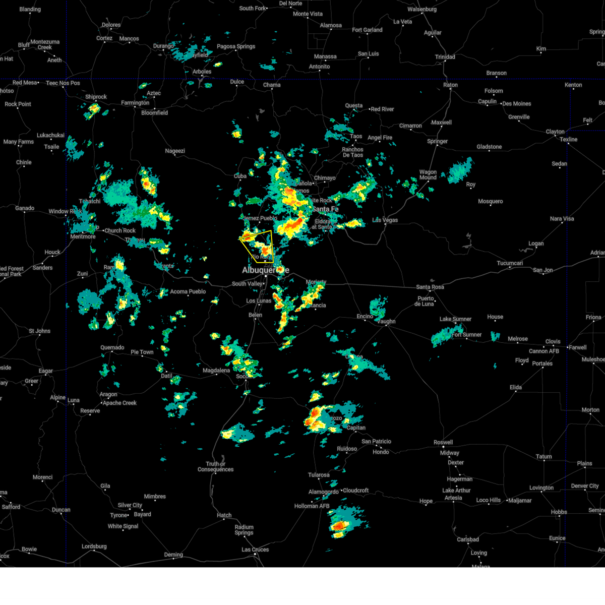
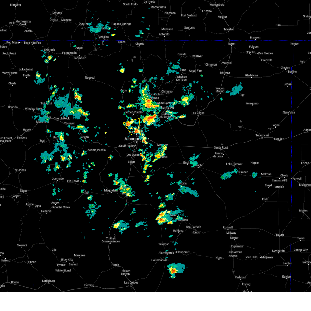
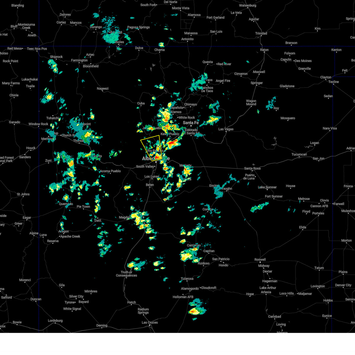
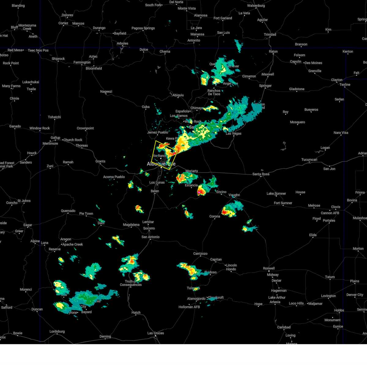
Hail Map for Zia Pueblo, NM
The Zia Pueblo, NM area has had 0 reports of on-the-ground hail by trained spotters, and has been under severe weather warnings 11 times during the past 12 months. Doppler radar has detected hail at or near Zia Pueblo, NM on 35 occasions, including 2 occasions during the past year.
| Name: | Zia Pueblo, NM |
| Where Located: | 31.8 miles N of Albuquerque, NM |
| Map: | Google Map for Zia Pueblo, NM |
| Population: | 737 |
| Housing Units: | 201 |
| More Info: | Search Google for Zia Pueblo, NM |
1
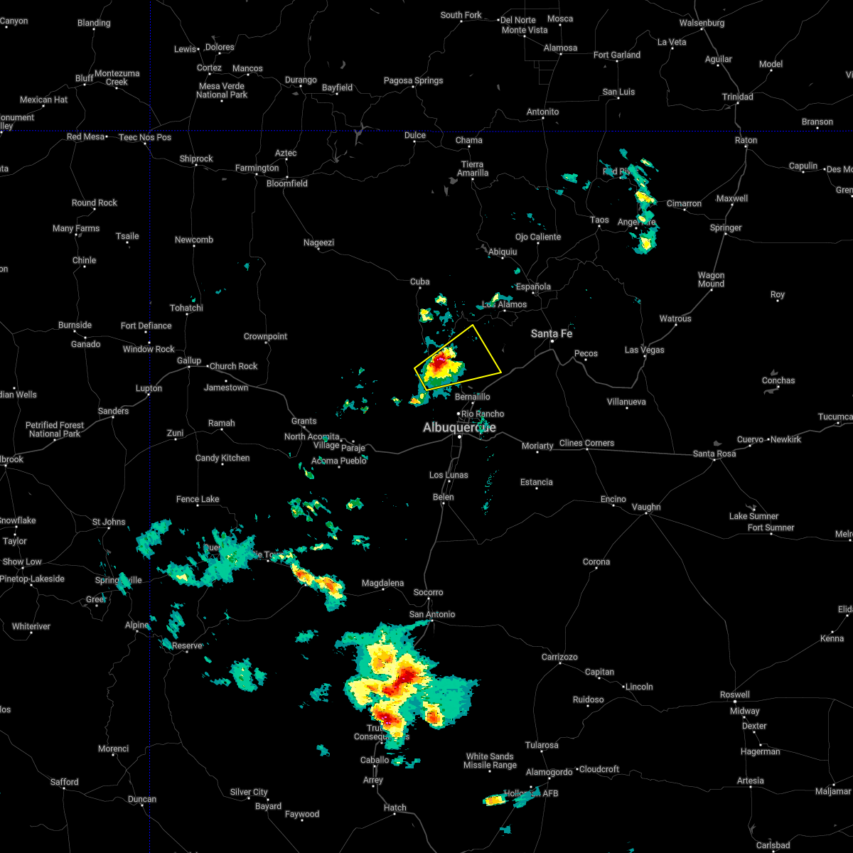
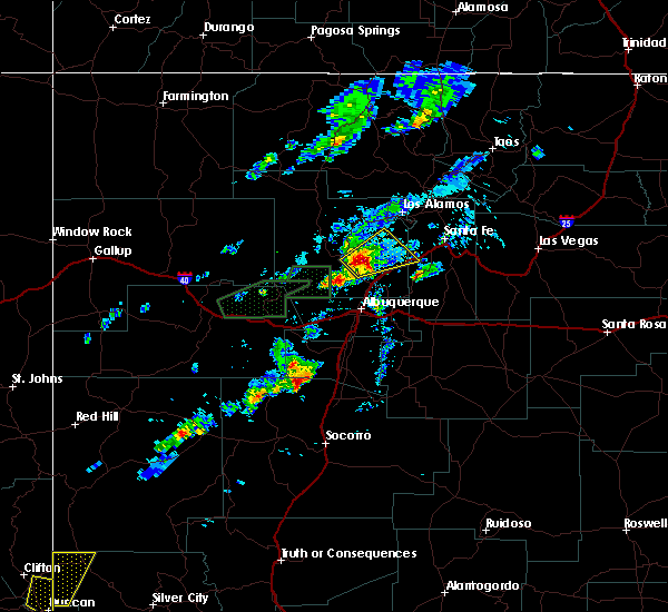
The Top Recent Hail Date for Zia Pueblo, NM is Thursday, September 5, 2024 (10th out of 35)

Hail and Wind Damage Spotted near Zia Pueblo, NM
| Date / Time | Report Details |
|---|---|
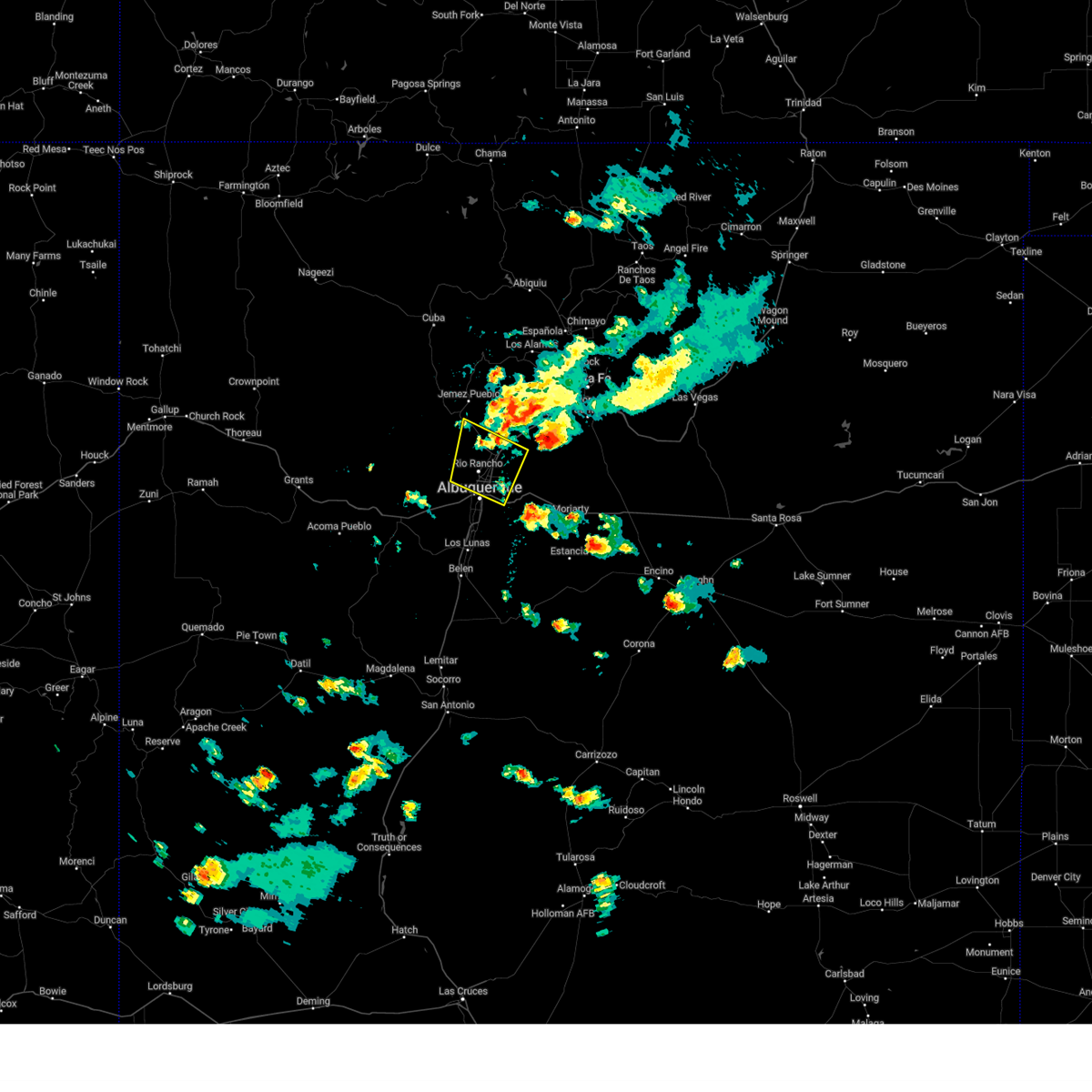
| 5/4/2025 2:33 PM MDT |
 the severe thunderstorm warning has been cancelled and is no longer in effect the severe thunderstorm warning has been cancelled and is no longer in effect
|
| 5/4/2025 2:22 PM MDT |
 At 222 pm mdt, a severe thunderstorm was located over rio rancho, moving north at 30 mph (radar indicated). Hazards include 60 mph wind gusts and quarter size hail. Hail damage to vehicles is expected. expect wind damage to roofs, siding, and trees. locations impacted include, rio rancho, bernalillo, corrales, mariposa, northern meadows, rio rancho city center, enchanted hills, vista hills, cabezon and zia pueblo. this includes the following highways, highway 550 between mile markers 4 and 18. Interstate 25 between mile markers 236 and 238. At 222 pm mdt, a severe thunderstorm was located over rio rancho, moving north at 30 mph (radar indicated). Hazards include 60 mph wind gusts and quarter size hail. Hail damage to vehicles is expected. expect wind damage to roofs, siding, and trees. locations impacted include, rio rancho, bernalillo, corrales, mariposa, northern meadows, rio rancho city center, enchanted hills, vista hills, cabezon and zia pueblo. this includes the following highways, highway 550 between mile markers 4 and 18. Interstate 25 between mile markers 236 and 238.
|
| 5/4/2025 2:22 PM MDT |
 the severe thunderstorm warning has been cancelled and is no longer in effect the severe thunderstorm warning has been cancelled and is no longer in effect
|
| 5/4/2025 2:09 PM MDT |
 Svrabq the national weather service in albuquerque has issued a * severe thunderstorm warning for, bernalillo county in central new mexico, south central sandoval county in north central new mexico, * until 300 pm mdt. * at 209 pm mdt, a severe thunderstorm was located over los ranchos de albuquerque, or 5 miles north of albuquerque, moving north at 30 mph (radar indicated). Hazards include 60 mph wind gusts and quarter size hail. Hail damage to vehicles is expected. Expect wind damage to roofs, siding, and trees. Svrabq the national weather service in albuquerque has issued a * severe thunderstorm warning for, bernalillo county in central new mexico, south central sandoval county in north central new mexico, * until 300 pm mdt. * at 209 pm mdt, a severe thunderstorm was located over los ranchos de albuquerque, or 5 miles north of albuquerque, moving north at 30 mph (radar indicated). Hazards include 60 mph wind gusts and quarter size hail. Hail damage to vehicles is expected. Expect wind damage to roofs, siding, and trees.
|
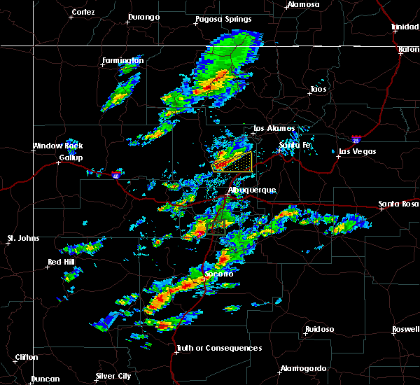
| 9/5/2024 5:39 PM MDT |
 the severe thunderstorm warning has been cancelled and is no longer in effect the severe thunderstorm warning has been cancelled and is no longer in effect
|
| 9/5/2024 5:31 PM MDT |
 At 531 pm mdt, severe thunderstorms were located along a line extending from 6 miles west of northern meadows to sandia heights, moving southwest at 20 mph (public). Hazards include 60 mph wind gusts. Expect damage to roofs, siding, and trees. locations impacted include, northern albuquerque, rio rancho, bernalillo, corrales, los ranchos de albuquerque, enchanted hills, mariposa, cabezon, coronado state monument, and vista hills. this includes the following highways, interstate 40 between mile markers 159 and 168. interstate 25 between mile markers 228 and 249. Highway 550 between mile markers 1 and 20. At 531 pm mdt, severe thunderstorms were located along a line extending from 6 miles west of northern meadows to sandia heights, moving southwest at 20 mph (public). Hazards include 60 mph wind gusts. Expect damage to roofs, siding, and trees. locations impacted include, northern albuquerque, rio rancho, bernalillo, corrales, los ranchos de albuquerque, enchanted hills, mariposa, cabezon, coronado state monument, and vista hills. this includes the following highways, interstate 40 between mile markers 159 and 168. interstate 25 between mile markers 228 and 249. Highway 550 between mile markers 1 and 20.
|
| 9/5/2024 5:09 PM MDT |
 Svrabq the national weather service in albuquerque has issued a * severe thunderstorm warning for, southeastern sandoval county in north central new mexico, bernalillo county in central new mexico, * until 615 pm mdt. * at 509 pm mdt, severe thunderstorms were located along a line extending from near mariposa to 7 miles southeast of santa ana pueblo, moving southwest at 15 mph (public). Hazards include 60 mph wind gusts. expect damage to roofs, siding, and trees Svrabq the national weather service in albuquerque has issued a * severe thunderstorm warning for, southeastern sandoval county in north central new mexico, bernalillo county in central new mexico, * until 615 pm mdt. * at 509 pm mdt, severe thunderstorms were located along a line extending from near mariposa to 7 miles southeast of santa ana pueblo, moving southwest at 15 mph (public). Hazards include 60 mph wind gusts. expect damage to roofs, siding, and trees
|
| 7/21/2024 6:57 PM MDT |
 Svrabq the national weather service in albuquerque has issued a * severe thunderstorm warning for, north central valencia county in central new mexico, south central sandoval county in north central new mexico, bernalillo county in central new mexico, * until 800 pm mdt. * at 657 pm mdt, a severe thunderstorm was located 9 miles west of northern meadows, or 11 miles west of rio rancho, moving southeast at 30 mph (radar indicated). Hazards include 60 mph wind gusts and penny size hail. expect damage to roofs, siding, and trees Svrabq the national weather service in albuquerque has issued a * severe thunderstorm warning for, north central valencia county in central new mexico, south central sandoval county in north central new mexico, bernalillo county in central new mexico, * until 800 pm mdt. * at 657 pm mdt, a severe thunderstorm was located 9 miles west of northern meadows, or 11 miles west of rio rancho, moving southeast at 30 mph (radar indicated). Hazards include 60 mph wind gusts and penny size hail. expect damage to roofs, siding, and trees
|
| 7/21/2024 6:30 PM MDT |
 the severe thunderstorm warning has been cancelled and is no longer in effect the severe thunderstorm warning has been cancelled and is no longer in effect
|
| 7/21/2024 6:30 PM MDT |
 At 629 pm mdt, severe thunderstorms were located along a line extending from 10 miles northwest of jemez pueblo to near torreon to 8 miles southeast of marquez, moving southeast at 40 mph (radar indicated). Hazards include 60 mph wind gusts. Expect damage to roofs, siding, and trees. locations impacted include, northwestern albuquerque, rio rancho, san ysidro, mesita, northern meadows, mariposa, zia pueblo, rio rancho city center, jemez pueblo, and tohajiilee. this includes the following highways, interstate 40 between mile markers 116 and 146. Highway 550 between mile markers 5 and 45. At 629 pm mdt, severe thunderstorms were located along a line extending from 10 miles northwest of jemez pueblo to near torreon to 8 miles southeast of marquez, moving southeast at 40 mph (radar indicated). Hazards include 60 mph wind gusts. Expect damage to roofs, siding, and trees. locations impacted include, northwestern albuquerque, rio rancho, san ysidro, mesita, northern meadows, mariposa, zia pueblo, rio rancho city center, jemez pueblo, and tohajiilee. this includes the following highways, interstate 40 between mile markers 116 and 146. Highway 550 between mile markers 5 and 45.
|
| 7/21/2024 6:12 PM MDT |
 Svrabq the national weather service in albuquerque has issued a * severe thunderstorm warning for, northeastern cibola county in west central new mexico, east central mckinley county in west central new mexico, northwestern valencia county in central new mexico, south central sandoval county in north central new mexico, bernalillo county in central new mexico, * until 700 pm mdt. * at 612 pm mdt, severe thunderstorms were located along a line extending from 12 miles southwest of fenton lake state park to 9 miles northwest of torreon to marquez, moving south at 45 mph (radar indicated). Hazards include 60 mph wind gusts. expect damage to roofs, siding, and trees Svrabq the national weather service in albuquerque has issued a * severe thunderstorm warning for, northeastern cibola county in west central new mexico, east central mckinley county in west central new mexico, northwestern valencia county in central new mexico, south central sandoval county in north central new mexico, bernalillo county in central new mexico, * until 700 pm mdt. * at 612 pm mdt, severe thunderstorms were located along a line extending from 12 miles southwest of fenton lake state park to 9 miles northwest of torreon to marquez, moving south at 45 mph (radar indicated). Hazards include 60 mph wind gusts. expect damage to roofs, siding, and trees
|
| 7/8/2024 5:08 PM MDT |
 The storm which prompted the warning has weakened below severe limits, and no longer poses an immediate threat to life or property. therefore, the warning will be allowed to expire. however, small hail is still possible with this thunderstorm. The storm which prompted the warning has weakened below severe limits, and no longer poses an immediate threat to life or property. therefore, the warning will be allowed to expire. however, small hail is still possible with this thunderstorm.
|
| 7/8/2024 4:58 PM MDT |
 At 458 pm mdt, a severe thunderstorm was located over san ysidro, or 19 miles north of rio rancho, moving south at 20 mph (radar indicated). Hazards include 60 mph wind gusts and half dollar size hail. Hail damage to vehicles is expected. expect wind damage to roofs, siding, and trees. locations impacted include, san ysidro, zia pueblo, jemez pueblo, canon, and ponderosa. This includes highway 550 between mile markers 9 and 37. At 458 pm mdt, a severe thunderstorm was located over san ysidro, or 19 miles north of rio rancho, moving south at 20 mph (radar indicated). Hazards include 60 mph wind gusts and half dollar size hail. Hail damage to vehicles is expected. expect wind damage to roofs, siding, and trees. locations impacted include, san ysidro, zia pueblo, jemez pueblo, canon, and ponderosa. This includes highway 550 between mile markers 9 and 37.
|
| 7/8/2024 4:40 PM MDT |
 Svrabq the national weather service in albuquerque has issued a * severe thunderstorm warning for, south central sandoval county in north central new mexico, * until 515 pm mdt. * at 440 pm mdt, a severe thunderstorm was located near jemez pueblo, or 25 miles north of rio rancho, moving south at 20 mph (radar indicated). Hazards include 60 mph wind gusts and half dollar size hail. Hail damage to vehicles is expected. Expect wind damage to roofs, siding, and trees. Svrabq the national weather service in albuquerque has issued a * severe thunderstorm warning for, south central sandoval county in north central new mexico, * until 515 pm mdt. * at 440 pm mdt, a severe thunderstorm was located near jemez pueblo, or 25 miles north of rio rancho, moving south at 20 mph (radar indicated). Hazards include 60 mph wind gusts and half dollar size hail. Hail damage to vehicles is expected. Expect wind damage to roofs, siding, and trees.
|
| 6/29/2024 9:32 PM MDT |
 The warning has been allowed to expire. however, heavy rain and flash flooding is still possible with this thunderstorm. The warning has been allowed to expire. however, heavy rain and flash flooding is still possible with this thunderstorm.
|
| 6/29/2024 9:31 PM MDT |
 The warning has been allowed to expire. however, heavy rain and flash flooding is still possible with this thunderstorm. The warning has been allowed to expire. however, heavy rain and flash flooding is still possible with this thunderstorm.
|
| 6/29/2024 9:00 PM MDT |
 Svrabq the national weather service in albuquerque has issued a * severe thunderstorm warning for, southeastern sandoval county in north central new mexico, bernalillo county in central new mexico, * until 930 pm mdt. * at 859 pm mdt, a severe thunderstorm was located over southern rio rancho, moving north at 15 mph (radar indicated). Hazards include 60 mph wind gusts and penny size hail. expect damage to roofs, siding, and trees Svrabq the national weather service in albuquerque has issued a * severe thunderstorm warning for, southeastern sandoval county in north central new mexico, bernalillo county in central new mexico, * until 930 pm mdt. * at 859 pm mdt, a severe thunderstorm was located over southern rio rancho, moving north at 15 mph (radar indicated). Hazards include 60 mph wind gusts and penny size hail. expect damage to roofs, siding, and trees
|
| 5/11/2024 1:15 PM MDT |
 Svrabq the national weather service in albuquerque has issued a * severe thunderstorm warning for, east central sandoval county in north central new mexico, * until 215 pm mdt. * at 114 pm mdt, a severe thunderstorm was located over zia pueblo, or 17 miles north of rio rancho, moving northeast at 20 mph (radar indicated). Hazards include 60 mph wind gusts and quarter size hail. Hail damage to vehicles is expected. Expect wind damage to roofs, siding, and trees. Svrabq the national weather service in albuquerque has issued a * severe thunderstorm warning for, east central sandoval county in north central new mexico, * until 215 pm mdt. * at 114 pm mdt, a severe thunderstorm was located over zia pueblo, or 17 miles north of rio rancho, moving northeast at 20 mph (radar indicated). Hazards include 60 mph wind gusts and quarter size hail. Hail damage to vehicles is expected. Expect wind damage to roofs, siding, and trees.
|
| 5/11/2024 12:53 PM MDT |
 the severe thunderstorm warning has been cancelled and is no longer in effect the severe thunderstorm warning has been cancelled and is no longer in effect
|
| 5/11/2024 12:32 PM MDT |
 Svrabq the national weather service in albuquerque has issued a * severe thunderstorm warning for, south central sandoval county in north central new mexico, * until 130 pm mdt. * at 1232 pm mdt, a severe thunderstorm was located 10 miles northeast of marquez, or 27 miles northeast of laguna pueblo, moving northeast at 25 mph (radar indicated). Hazards include 60 mph wind gusts and quarter size hail. Hail damage to vehicles is expected. Expect wind damage to roofs, siding, and trees. Svrabq the national weather service in albuquerque has issued a * severe thunderstorm warning for, south central sandoval county in north central new mexico, * until 130 pm mdt. * at 1232 pm mdt, a severe thunderstorm was located 10 miles northeast of marquez, or 27 miles northeast of laguna pueblo, moving northeast at 25 mph (radar indicated). Hazards include 60 mph wind gusts and quarter size hail. Hail damage to vehicles is expected. Expect wind damage to roofs, siding, and trees.
|
| 6/8/2022 4:52 PM MDT |
 The severe thunderstorm warning for southeastern sandoval county will expire at 500 pm mdt, the storm which prompted the warning has weakened below severe limits, and no longer poses an immediate threat to life or property. therefore, the warning will be allowed to expire. however gusty winds and heavy rain are still possible with this thunderstorm. The severe thunderstorm warning for southeastern sandoval county will expire at 500 pm mdt, the storm which prompted the warning has weakened below severe limits, and no longer poses an immediate threat to life or property. therefore, the warning will be allowed to expire. however gusty winds and heavy rain are still possible with this thunderstorm.
|
| 6/8/2022 4:31 PM MDT |
 At 431 pm mdt, a severe thunderstorm was located over zia pueblo, or 17 miles northwest of bernalillo, moving northeast at 35 mph (radar indicated). Hazards include 60 mph wind gusts and quarter size hail. Hail damage to vehicles is expected. expect wind damage to roofs, siding, and trees. locations impacted include, santo domingo pueblo, san ysidro, zia pueblo, kewa pueblo, jemez pueblo and ponderosa. this includes highway 550 between mile markers 12 and 32. hail threat, radar indicated max hail size, 1. 00 in wind threat, radar indicated max wind gust, 60 mph. At 431 pm mdt, a severe thunderstorm was located over zia pueblo, or 17 miles northwest of bernalillo, moving northeast at 35 mph (radar indicated). Hazards include 60 mph wind gusts and quarter size hail. Hail damage to vehicles is expected. expect wind damage to roofs, siding, and trees. locations impacted include, santo domingo pueblo, san ysidro, zia pueblo, kewa pueblo, jemez pueblo and ponderosa. this includes highway 550 between mile markers 12 and 32. hail threat, radar indicated max hail size, 1. 00 in wind threat, radar indicated max wind gust, 60 mph.
|
| 6/8/2022 4:09 PM MDT |
 At 408 pm mdt, a severe thunderstorm was located 12 miles southwest of san ysidro, or 19 miles northwest of rio rancho, moving northeast at 35 mph (radar indicated). Hazards include 60 mph wind gusts and half dollar size hail. Hail damage to vehicles is expected. Expect wind damage to roofs, siding, and trees. At 408 pm mdt, a severe thunderstorm was located 12 miles southwest of san ysidro, or 19 miles northwest of rio rancho, moving northeast at 35 mph (radar indicated). Hazards include 60 mph wind gusts and half dollar size hail. Hail damage to vehicles is expected. Expect wind damage to roofs, siding, and trees.
|
| 7/10/2021 4:02 PM MDT |
 At 402 pm mdt, a severe thunderstorm was located near san ysidro, or 19 miles northwest of rio rancho, moving southwest at 15 mph (radar indicated). Hazards include ping pong ball size hail and 60 mph wind gusts. People and animals outdoors will be injured. expect hail damage to roofs, siding, windows, and vehicles. expect wind damage to roofs, siding, and trees. locations impacted include, northwestern rio rancho, san ysidro, northern meadows and zia pueblo. This includes highway 550 between mile markers 15 and 32. At 402 pm mdt, a severe thunderstorm was located near san ysidro, or 19 miles northwest of rio rancho, moving southwest at 15 mph (radar indicated). Hazards include ping pong ball size hail and 60 mph wind gusts. People and animals outdoors will be injured. expect hail damage to roofs, siding, windows, and vehicles. expect wind damage to roofs, siding, and trees. locations impacted include, northwestern rio rancho, san ysidro, northern meadows and zia pueblo. This includes highway 550 between mile markers 15 and 32.
|
| 7/10/2021 3:48 PM MDT |
 At 348 pm mdt, a severe thunderstorm was located over san ysidro, or 20 miles northwest of rio rancho, moving southwest at 15 mph (radar indicated). Hazards include 60 mph wind gusts and quarter size hail. Hail damage to vehicles is expected. Expect wind damage to roofs, siding, and trees. At 348 pm mdt, a severe thunderstorm was located over san ysidro, or 20 miles northwest of rio rancho, moving southwest at 15 mph (radar indicated). Hazards include 60 mph wind gusts and quarter size hail. Hail damage to vehicles is expected. Expect wind damage to roofs, siding, and trees.
|
| 5/31/2021 1:05 PM MDT |
 At 105 pm mdt, a severe thunderstorm was located near san ysidro, or 18 miles northwest of rio rancho, moving east at 10 mph (radar indicated). Hazards include 60 mph wind gusts and quarter size hail. Hail damage to vehicles is expected. Expect wind damage to roofs, siding, and trees. At 105 pm mdt, a severe thunderstorm was located near san ysidro, or 18 miles northwest of rio rancho, moving east at 10 mph (radar indicated). Hazards include 60 mph wind gusts and quarter size hail. Hail damage to vehicles is expected. Expect wind damage to roofs, siding, and trees.
|
| 2/13/2021 6:15 PM MST |
 At 614 pm mst, severe thunderstorms with snow and hail were located along a line extending from san felipe pueblo to albuquerque, moving east at 35 mph (public). Hazards include 60 mph wind gusts. Expect damage to roofs, siding, and trees. locations impacted include, albuquerque, rio rancho, corrales, bernalillo, los ranchos de albuquerque, santo domingo pueblo, tijeras, mariposa, san felipe pueblo and coronado state monument. this includes the following highways, interstate 40 between mile markers 151 and 168, and between mile markers 173 and 178. interstate 25 between mile markers 223 and 258. Highway 550 between mile markers 1 and 18. At 614 pm mst, severe thunderstorms with snow and hail were located along a line extending from san felipe pueblo to albuquerque, moving east at 35 mph (public). Hazards include 60 mph wind gusts. Expect damage to roofs, siding, and trees. locations impacted include, albuquerque, rio rancho, corrales, bernalillo, los ranchos de albuquerque, santo domingo pueblo, tijeras, mariposa, san felipe pueblo and coronado state monument. this includes the following highways, interstate 40 between mile markers 151 and 168, and between mile markers 173 and 178. interstate 25 between mile markers 223 and 258. Highway 550 between mile markers 1 and 18.
|
| 2/13/2021 6:00 PM MST |
 At 600 pm mst, severe thunderstorms were located along a line extending from 6 miles west of san felipe pueblo to albuquerque, moving northeast at 45 mph (radar indicated). Hazards include 60 mph wind gusts. expect damage to roofs, siding, and trees At 600 pm mst, severe thunderstorms were located along a line extending from 6 miles west of san felipe pueblo to albuquerque, moving northeast at 45 mph (radar indicated). Hazards include 60 mph wind gusts. expect damage to roofs, siding, and trees
|
| 8/2/2020 4:19 PM MDT |
 At 419 pm mdt, a severe thunderstorm was located over enchanted hills, or near bernalillo, moving southeast at 25 mph (radar indicated). Hazards include 60 mph wind gusts and quarter size hail. Hail damage to vehicles is expected. expect wind damage to roofs, siding, and trees. locations impacted include, rio rancho, corrales, bernalillo, enchanted hills, mariposa, san felipe pueblo, coronado state monument, vista hills, sandia pueblo and santa ana pueblo. this includes the following highways, interstate 25 between mile markers 238 and 253. Highway 550 between mile markers 1 and 15. At 419 pm mdt, a severe thunderstorm was located over enchanted hills, or near bernalillo, moving southeast at 25 mph (radar indicated). Hazards include 60 mph wind gusts and quarter size hail. Hail damage to vehicles is expected. expect wind damage to roofs, siding, and trees. locations impacted include, rio rancho, corrales, bernalillo, enchanted hills, mariposa, san felipe pueblo, coronado state monument, vista hills, sandia pueblo and santa ana pueblo. this includes the following highways, interstate 25 between mile markers 238 and 253. Highway 550 between mile markers 1 and 15.
|
| 8/2/2020 4:05 PM MDT |
 At 405 pm mdt, a severe thunderstorm was located near mariposa, or 10 miles northwest of bernalillo, moving southeast at 20 mph (radar indicated). Hazards include 60 mph wind gusts and quarter size hail. Hail damage to vehicles is expected. Expect wind damage to roofs, siding, and trees. At 405 pm mdt, a severe thunderstorm was located near mariposa, or 10 miles northwest of bernalillo, moving southeast at 20 mph (radar indicated). Hazards include 60 mph wind gusts and quarter size hail. Hail damage to vehicles is expected. Expect wind damage to roofs, siding, and trees.
|
| 7/31/2020 5:47 PM MDT |
 At 546 pm mdt, a severe thunderstorm was located over san felipe pueblo, or 9 miles northeast of bernalillo, moving south at 20 mph (radar indicated). Hazards include 70 mph wind gusts and penny size hail. Expect considerable tree damage. damage is likely to mobile homes, roofs, and outbuildings. locations impacted include, rio rancho, corrales, bernalillo, santo domingo pueblo, enchanted hills, mariposa, san felipe pueblo, cabezon, coronado state monument and vista hills. this includes the following highways, interstate 25 between mile markers 237 and 263. Highway 550 between mile markers 1 and 13. At 546 pm mdt, a severe thunderstorm was located over san felipe pueblo, or 9 miles northeast of bernalillo, moving south at 20 mph (radar indicated). Hazards include 70 mph wind gusts and penny size hail. Expect considerable tree damage. damage is likely to mobile homes, roofs, and outbuildings. locations impacted include, rio rancho, corrales, bernalillo, santo domingo pueblo, enchanted hills, mariposa, san felipe pueblo, cabezon, coronado state monument and vista hills. this includes the following highways, interstate 25 between mile markers 237 and 263. Highway 550 between mile markers 1 and 13.
|
| 7/31/2020 5:31 PM MDT |
 At 530 pm mdt, a severe thunderstorm and accompanying outflow boundary was located over santo domingo pueblo, or 15 miles northeast of bernalillo, moving south at 25 mph (radar indicated). Hazards include 60 mph wind gusts and penny size hail. expect damage to roofs, siding, and trees At 530 pm mdt, a severe thunderstorm and accompanying outflow boundary was located over santo domingo pueblo, or 15 miles northeast of bernalillo, moving south at 25 mph (radar indicated). Hazards include 60 mph wind gusts and penny size hail. expect damage to roofs, siding, and trees
|
| 7/31/2018 8:00 PM MDT |
 The national weather service in albuquerque has issued a * severe thunderstorm warning for. south central sandoval county in north central new mexico. bernalillo county in central new mexico. until 845 pm mdt. At 759 pm mdt, a severe thunderstorm was located over zia pueblo,. The national weather service in albuquerque has issued a * severe thunderstorm warning for. south central sandoval county in north central new mexico. bernalillo county in central new mexico. until 845 pm mdt. At 759 pm mdt, a severe thunderstorm was located over zia pueblo,.
|
| 7/31/2018 7:31 PM MDT |
 At 731 pm mdt, a severe thunderstorm was located near jemez pueblo, or 26 miles north of bernalillo, moving south at 20 mph (radar indicated). Hazards include golf ball size hail and 70 mph wind gusts. People and animals outdoors will be injured. expect hail damage to roofs, siding, windows, and vehicles. expect considerable tree damage. wind damage is also likely to mobile homes, roofs, and outbuildings. Locations impacted include, jemez springs, san ysidro, jemez state monument, jemez pueblo, ponderosa and zia pueblo. At 731 pm mdt, a severe thunderstorm was located near jemez pueblo, or 26 miles north of bernalillo, moving south at 20 mph (radar indicated). Hazards include golf ball size hail and 70 mph wind gusts. People and animals outdoors will be injured. expect hail damage to roofs, siding, windows, and vehicles. expect considerable tree damage. wind damage is also likely to mobile homes, roofs, and outbuildings. Locations impacted include, jemez springs, san ysidro, jemez state monument, jemez pueblo, ponderosa and zia pueblo.
|
| 7/31/2018 7:08 PM MDT |
 At 708 pm mdt, a severe thunderstorm was located over jemez springs, or 20 miles southwest of los alamos, moving south at 20 mph (radar indicated). Hazards include golf ball size hail and 70 mph wind gusts. People and animals outdoors will be injured. expect hail damage to roofs, siding, windows, and vehicles. expect considerable tree damage. Wind damage is also likely to mobile homes, roofs, and outbuildings. At 708 pm mdt, a severe thunderstorm was located over jemez springs, or 20 miles southwest of los alamos, moving south at 20 mph (radar indicated). Hazards include golf ball size hail and 70 mph wind gusts. People and animals outdoors will be injured. expect hail damage to roofs, siding, windows, and vehicles. expect considerable tree damage. Wind damage is also likely to mobile homes, roofs, and outbuildings.
|
| 7/31/2018 6:52 PM MDT |
 At 652 pm mdt, a severe thunderstorm was located near jemez springs, or 22 miles southwest of los alamos, moving southwest at 30 mph (radar indicated). Hazards include two inch hail and 70 mph wind gusts. People and animals outdoors will be injured. expect hail damage to roofs, siding, windows, and vehicles. expect considerable tree damage. wind damage is also likely to mobile homes, roofs, and outbuildings. Locations impacted include, jemez springs, san ysidro, zia pueblo, jemez state monument, jemez pueblo and ponderosa. At 652 pm mdt, a severe thunderstorm was located near jemez springs, or 22 miles southwest of los alamos, moving southwest at 30 mph (radar indicated). Hazards include two inch hail and 70 mph wind gusts. People and animals outdoors will be injured. expect hail damage to roofs, siding, windows, and vehicles. expect considerable tree damage. wind damage is also likely to mobile homes, roofs, and outbuildings. Locations impacted include, jemez springs, san ysidro, zia pueblo, jemez state monument, jemez pueblo and ponderosa.
|
| 7/31/2018 6:29 PM MDT |
 The national weather service in albuquerque has issued a * severe thunderstorm warning for. east central sandoval county in north central new mexico. until 715 pm mdt. At 629 pm mdt, a severe thunderstorm was located 8 miles east of fenton lake state park, or 15 miles west of los alamos, moving. The national weather service in albuquerque has issued a * severe thunderstorm warning for. east central sandoval county in north central new mexico. until 715 pm mdt. At 629 pm mdt, a severe thunderstorm was located 8 miles east of fenton lake state park, or 15 miles west of los alamos, moving.
|
| 6/3/2018 2:34 PM MDT |
 At 233 pm mdt, severe thunderstorms were located along a line extending from 17 miles southeast of marquez to 11 miles west of los chaves to 25 miles west of bernardo, moving northeast at 30 mph (radar indicated). Hazards include 60 mph wind gusts and quarter size hail. Hail damage to vehicles is expected. Expect wind damage to roofs, siding, and trees. At 233 pm mdt, severe thunderstorms were located along a line extending from 17 miles southeast of marquez to 11 miles west of los chaves to 25 miles west of bernardo, moving northeast at 30 mph (radar indicated). Hazards include 60 mph wind gusts and quarter size hail. Hail damage to vehicles is expected. Expect wind damage to roofs, siding, and trees.
|
| 5/21/2018 3:22 PM MDT |
 At 322 pm mdt, severe thunderstorms were located along a line extending from near jemez pueblo to near la bajada, moving northeast at 35 mph (radar indicated). Hazards include 70 mph wind gusts and quarter size hail. Hail damage to vehicles is expected. expect considerable tree damage. wind damage is also likely to mobile homes, roofs, and outbuildings. locations impacted include, santo domingo pueblo, jemez springs, san ysidro, san felipe pueblo, kewa pueblo, cochiti pueblo, la bajada, jemez pueblo, zia pueblo and jemez state monument. This includes interstate 25 between mile markers 249 and 273. At 322 pm mdt, severe thunderstorms were located along a line extending from near jemez pueblo to near la bajada, moving northeast at 35 mph (radar indicated). Hazards include 70 mph wind gusts and quarter size hail. Hail damage to vehicles is expected. expect considerable tree damage. wind damage is also likely to mobile homes, roofs, and outbuildings. locations impacted include, santo domingo pueblo, jemez springs, san ysidro, san felipe pueblo, kewa pueblo, cochiti pueblo, la bajada, jemez pueblo, zia pueblo and jemez state monument. This includes interstate 25 between mile markers 249 and 273.
|
| 5/21/2018 3:05 PM MDT |
 At 304 pm mdt, severe thunderstorms were located along a line extending from 7 miles west of san ysidro to 7 miles northwest of golden, moving north at 40 mph (radar indicated). Hazards include 70 mph wind gusts and quarter size hail. Hail damage to vehicles is expected. expect considerable tree damage. wind damage is also likely to mobile homes, roofs, and outbuildings. locations impacted include, rio rancho, bernalillo, santo domingo pueblo, jemez springs, san ysidro, mariposa, san felipe pueblo, coronado state monument, jemez pueblo and santa ana pueblo. This includes interstate 25 between mile markers 239 and 273. At 304 pm mdt, severe thunderstorms were located along a line extending from 7 miles west of san ysidro to 7 miles northwest of golden, moving north at 40 mph (radar indicated). Hazards include 70 mph wind gusts and quarter size hail. Hail damage to vehicles is expected. expect considerable tree damage. wind damage is also likely to mobile homes, roofs, and outbuildings. locations impacted include, rio rancho, bernalillo, santo domingo pueblo, jemez springs, san ysidro, mariposa, san felipe pueblo, coronado state monument, jemez pueblo and santa ana pueblo. This includes interstate 25 between mile markers 239 and 273.
|
| 5/21/2018 2:44 PM MDT |
 At 243 pm mdt, severe thunderstorms were located along a line extending from 12 miles northeast of marquez to sandia park, moving north at 35 mph (radar indicated). Hazards include 60 mph wind gusts and quarter size hail. Hail damage to vehicles is expected. Expect wind damage to roofs, siding, and trees. At 243 pm mdt, severe thunderstorms were located along a line extending from 12 miles northeast of marquez to sandia park, moving north at 35 mph (radar indicated). Hazards include 60 mph wind gusts and quarter size hail. Hail damage to vehicles is expected. Expect wind damage to roofs, siding, and trees.
|
| 10/5/2017 4:11 PM MDT |
 The severe thunderstorm warning for southeastern sandoval county will expire at 415 pm mdt, the storm that prompted the warning has weakened below severe limits, and no longer poses an immediate threat to life or property. therefore the warning will be allowed to expire. however heavy rain is still possible with this thunderstorm. The severe thunderstorm warning for southeastern sandoval county will expire at 415 pm mdt, the storm that prompted the warning has weakened below severe limits, and no longer poses an immediate threat to life or property. therefore the warning will be allowed to expire. however heavy rain is still possible with this thunderstorm.
|
| 10/5/2017 3:42 PM MDT |
 At 342 pm mdt, a severe thunderstorm was located over zia pueblo, or 13 miles northwest of bernalillo, moving east at 25 mph (radar indicated). Hazards include 60 mph wind gusts and quarter size hail. Hail damage to vehicles is expected. expect wind damage to roofs, siding, and trees. locations impacted include, santo domingo pueblo, zia pueblo, san felipe pueblo, kewa pueblo, cochiti pueblo, cochiti lake, domingo, pena blanca and algodones. This includes interstate 25 between mile markers 252 and 259. At 342 pm mdt, a severe thunderstorm was located over zia pueblo, or 13 miles northwest of bernalillo, moving east at 25 mph (radar indicated). Hazards include 60 mph wind gusts and quarter size hail. Hail damage to vehicles is expected. expect wind damage to roofs, siding, and trees. locations impacted include, santo domingo pueblo, zia pueblo, san felipe pueblo, kewa pueblo, cochiti pueblo, cochiti lake, domingo, pena blanca and algodones. This includes interstate 25 between mile markers 252 and 259.
|
| 10/5/2017 3:25 PM MDT |
 At 324 pm mdt, a severe thunderstorm was located near san ysidro, or 17 miles northwest of rio rancho, moving east at 30 mph (radar indicated). Hazards include 60 mph wind gusts and quarter size hail. Hail damage to vehicles is expected. Expect wind damage to roofs, siding, and trees. At 324 pm mdt, a severe thunderstorm was located near san ysidro, or 17 miles northwest of rio rancho, moving east at 30 mph (radar indicated). Hazards include 60 mph wind gusts and quarter size hail. Hail damage to vehicles is expected. Expect wind damage to roofs, siding, and trees.
|
| 10/4/2017 5:09 PM MDT |
 At 509 pm mdt, a severe thunderstorm was located near zia pueblo, or 12 miles northwest of bernalillo, moving northeast at 25 mph (radar indicated). Hazards include 60 mph wind gusts and quarter size hail. Hail damage to vehicles is expected. Expect wind damage to roofs, siding, and trees. At 509 pm mdt, a severe thunderstorm was located near zia pueblo, or 12 miles northwest of bernalillo, moving northeast at 25 mph (radar indicated). Hazards include 60 mph wind gusts and quarter size hail. Hail damage to vehicles is expected. Expect wind damage to roofs, siding, and trees.
|
| 9/30/2017 5:40 PM MDT |
 At 539 pm mdt, a severe thunderstorm was located over mariposa, or 8 miles north of rio rancho, moving east at 30 mph (radar indicated). Hazards include 60 mph wind gusts and quarter size hail. Hail damage to vehicles is expected. Expect wind damage to roofs, siding, and trees. At 539 pm mdt, a severe thunderstorm was located over mariposa, or 8 miles north of rio rancho, moving east at 30 mph (radar indicated). Hazards include 60 mph wind gusts and quarter size hail. Hail damage to vehicles is expected. Expect wind damage to roofs, siding, and trees.
|
| 9/30/2017 4:17 PM MDT |
 At 417 pm mdt, a severe thunderstorm was located 7 miles southeast of zia pueblo, or 10 miles north of bernalillo, moving east at 15 mph (radar indicated). Hazards include golf ball size hail and 60 mph wind gusts. People and animals outdoors will be injured. expect hail damage to roofs, siding, windows, and vehicles. expect wind damage to roofs, siding, and trees. locations impacted include, northern rio rancho, santo domingo pueblo, zia pueblo, san felipe pueblo, kewa pueblo, cochiti pueblo, santa ana pueblo, algodones and pena blanca. This includes interstate 25 between mile markers 245 and 258. At 417 pm mdt, a severe thunderstorm was located 7 miles southeast of zia pueblo, or 10 miles north of bernalillo, moving east at 15 mph (radar indicated). Hazards include golf ball size hail and 60 mph wind gusts. People and animals outdoors will be injured. expect hail damage to roofs, siding, windows, and vehicles. expect wind damage to roofs, siding, and trees. locations impacted include, northern rio rancho, santo domingo pueblo, zia pueblo, san felipe pueblo, kewa pueblo, cochiti pueblo, santa ana pueblo, algodones and pena blanca. This includes interstate 25 between mile markers 245 and 258.
|
| 9/30/2017 4:10 PM MDT |
 The severe thunderstorm warning for central sandoval county will expire at 415 pm mdt, the storm which prompted the warning has weakened below severe limits, and no longer poses an immediate threat to life or property. therefore the warning will be allowed to expire. however small hail, gusty winds and heavy rain are still possible with this thunderstorm. The severe thunderstorm warning for central sandoval county will expire at 415 pm mdt, the storm which prompted the warning has weakened below severe limits, and no longer poses an immediate threat to life or property. therefore the warning will be allowed to expire. however small hail, gusty winds and heavy rain are still possible with this thunderstorm.
|
| 9/30/2017 4:06 PM MDT |
 At 406 pm mdt, a severe thunderstorm was located near mariposa, or 9 miles northwest of bernalillo, moving east at 20 mph (radar indicated). Hazards include ping pong ball size hail and 60 mph wind gusts. People and animals outdoors will be injured. expect hail damage to roofs, siding, windows, and vehicles. Expect wind damage to roofs, siding, and trees. At 406 pm mdt, a severe thunderstorm was located near mariposa, or 9 miles northwest of bernalillo, moving east at 20 mph (radar indicated). Hazards include ping pong ball size hail and 60 mph wind gusts. People and animals outdoors will be injured. expect hail damage to roofs, siding, windows, and vehicles. Expect wind damage to roofs, siding, and trees.
|
| 9/30/2017 3:53 PM MDT |
 At 353 pm mdt, a severe thunderstorm was located near san ysidro, or 23 miles north of rio rancho, moving east at 20 mph (radar indicated). Hazards include 60 mph wind gusts and quarter size hail. Hail damage to vehicles is expected. expect wind damage to roofs, siding, and trees. Locations impacted include, jemez springs, san ysidro, zia pueblo, jemez state monument, jemez pueblo and ponderosa. At 353 pm mdt, a severe thunderstorm was located near san ysidro, or 23 miles north of rio rancho, moving east at 20 mph (radar indicated). Hazards include 60 mph wind gusts and quarter size hail. Hail damage to vehicles is expected. expect wind damage to roofs, siding, and trees. Locations impacted include, jemez springs, san ysidro, zia pueblo, jemez state monument, jemez pueblo and ponderosa.
|
| 9/30/2017 3:52 PM MDT |
 At 352 pm mdt, a severe thunderstorm was located near mariposa, or 11 miles north of rio rancho, moving east at 20 mph (radar indicated). Hazards include 60 mph wind gusts and quarter size hail. Hail damage to vehicles is expected. expect wind damage to roofs, siding, and trees. Locations impacted include, rio rancho, corrales, san ysidro, northern meadows, mariposa, zia pueblo and rio rancho city center. At 352 pm mdt, a severe thunderstorm was located near mariposa, or 11 miles north of rio rancho, moving east at 20 mph (radar indicated). Hazards include 60 mph wind gusts and quarter size hail. Hail damage to vehicles is expected. expect wind damage to roofs, siding, and trees. Locations impacted include, rio rancho, corrales, san ysidro, northern meadows, mariposa, zia pueblo and rio rancho city center.
|
| 9/30/2017 3:36 PM MDT |
 At 336 pm mdt, a severe thunderstorm was located near san ysidro, or 25 miles northwest of rio rancho, moving east at 20 mph (radar indicated). Hazards include 60 mph wind gusts and half dollar size hail. Hail damage to vehicles is expected. expect wind damage to roofs, siding, and trees. Locations impacted include, jemez springs, san ysidro, zia pueblo, jemez state monument, jemez pueblo and ponderosa. At 336 pm mdt, a severe thunderstorm was located near san ysidro, or 25 miles northwest of rio rancho, moving east at 20 mph (radar indicated). Hazards include 60 mph wind gusts and half dollar size hail. Hail damage to vehicles is expected. expect wind damage to roofs, siding, and trees. Locations impacted include, jemez springs, san ysidro, zia pueblo, jemez state monument, jemez pueblo and ponderosa.
|
| 9/30/2017 3:29 PM MDT |
 At 329 pm mdt, a severe thunderstorm was located 9 miles northwest of northern meadows, or 13 miles northwest of rio rancho, moving east at 20 mph (radar indicated). Hazards include 60 mph wind gusts and half dollar size hail. Hail damage to vehicles is expected. expect wind damage to roofs, siding, and trees. Locations impacted include, rio rancho, corrales, san ysidro, northern meadows, mariposa, zia pueblo and rio rancho city center. At 329 pm mdt, a severe thunderstorm was located 9 miles northwest of northern meadows, or 13 miles northwest of rio rancho, moving east at 20 mph (radar indicated). Hazards include 60 mph wind gusts and half dollar size hail. Hail damage to vehicles is expected. expect wind damage to roofs, siding, and trees. Locations impacted include, rio rancho, corrales, san ysidro, northern meadows, mariposa, zia pueblo and rio rancho city center.
|
| 9/30/2017 3:16 PM MDT |
 At 316 pm mdt, a severe thunderstorm was located 12 miles west of san ysidro, or 29 miles south of cuba, moving east at 20 mph (radar indicated). Hazards include 60 mph wind gusts and quarter size hail. Hail damage to vehicles is expected. Expect wind damage to roofs, siding, and trees. At 316 pm mdt, a severe thunderstorm was located 12 miles west of san ysidro, or 29 miles south of cuba, moving east at 20 mph (radar indicated). Hazards include 60 mph wind gusts and quarter size hail. Hail damage to vehicles is expected. Expect wind damage to roofs, siding, and trees.
|
| 9/30/2017 3:15 PM MDT |
 At 315 pm mdt, a severe thunderstorm was located 13 miles west of northern meadows, or 17 miles northwest of rio rancho, moving east at 20 mph (radar indicated). Hazards include 60 mph wind gusts and quarter size hail. Hail damage to vehicles is expected. Expect wind damage to roofs, siding, and trees. At 315 pm mdt, a severe thunderstorm was located 13 miles west of northern meadows, or 17 miles northwest of rio rancho, moving east at 20 mph (radar indicated). Hazards include 60 mph wind gusts and quarter size hail. Hail damage to vehicles is expected. Expect wind damage to roofs, siding, and trees.
|
| 7/1/2017 4:31 PM MDT |
 At 431 pm mdt, a severe thunderstorm was located 7 miles southwest of san ysidro, or 19 miles northwest of rio rancho, moving east at 25 mph (radar indicated). Hazards include 60 mph wind gusts and quarter size hail. Hail damage to vehicles is expected. expect wind damage to roofs, siding, and trees. Locations impacted include, san ysidro, zia pueblo, jemez pueblo and ponderosa. At 431 pm mdt, a severe thunderstorm was located 7 miles southwest of san ysidro, or 19 miles northwest of rio rancho, moving east at 25 mph (radar indicated). Hazards include 60 mph wind gusts and quarter size hail. Hail damage to vehicles is expected. expect wind damage to roofs, siding, and trees. Locations impacted include, san ysidro, zia pueblo, jemez pueblo and ponderosa.
|
| 7/1/2017 4:14 PM MDT |
 At 414 pm mdt, a severe thunderstorm was located 14 miles west of san ysidro, or 25 miles northwest of rio rancho, moving east at 20 mph (radar indicated). Hazards include 60 mph wind gusts and quarter size hail. Hail damage to vehicles is expected. Expect wind damage to roofs, siding, and trees. At 414 pm mdt, a severe thunderstorm was located 14 miles west of san ysidro, or 25 miles northwest of rio rancho, moving east at 20 mph (radar indicated). Hazards include 60 mph wind gusts and quarter size hail. Hail damage to vehicles is expected. Expect wind damage to roofs, siding, and trees.
|
| 6/6/2017 2:24 PM MDT |
 At 223 pm mdt, a severe thunderstorm was located near mariposa, or 8 miles northwest of bernalillo, moving southeast at 25 mph (radar indicated). Hazards include 60 mph wind gusts and quarter size hail. Hail damage to vehicles is expected. Expect wind damage to roofs, siding, and trees. At 223 pm mdt, a severe thunderstorm was located near mariposa, or 8 miles northwest of bernalillo, moving southeast at 25 mph (radar indicated). Hazards include 60 mph wind gusts and quarter size hail. Hail damage to vehicles is expected. Expect wind damage to roofs, siding, and trees.
|
| 5/9/2017 4:10 PM MDT |
 At 410 pm mdt, a severe thunderstorm was located over southeastern rio rancho, moving northwest at 25 mph (radar indicated). Hazards include 60 mph wind gusts and quarter size hail. Hail damage to vehicles is expected. Expect wind damage to roofs, siding, and trees. At 410 pm mdt, a severe thunderstorm was located over southeastern rio rancho, moving northwest at 25 mph (radar indicated). Hazards include 60 mph wind gusts and quarter size hail. Hail damage to vehicles is expected. Expect wind damage to roofs, siding, and trees.
|
| 7/29/2016 4:55 PM MDT |
 The severe thunderstorm warning for southeastern sandoval county will expire at 500 pm mdt, the storm which prompted the warning has weakened below severe limits, and no longer pose an immediate threat to life or property. therefore the warning will be allowed to expire. however small hail, gusty winds and heavy rain are still possible with this thunderstorm. The severe thunderstorm warning for southeastern sandoval county will expire at 500 pm mdt, the storm which prompted the warning has weakened below severe limits, and no longer pose an immediate threat to life or property. therefore the warning will be allowed to expire. however small hail, gusty winds and heavy rain are still possible with this thunderstorm.
|
| 7/29/2016 4:38 PM MDT |
 At 438 pm mdt, a severe thunderstorm was located near zia pueblo, or 13 miles north of rio rancho, moving southeast at 30 mph (trained weather spotters). Hazards include 60 mph wind gusts and quarter size hail. Hail damage to vehicles is expected. expect wind damage to roofs, siding, and trees. Locations impacted include, northwestern rio rancho, san ysidro, zia pueblo, san felipe pueblo, mariposa, jemez pueblo, ponderosa and algodones. At 438 pm mdt, a severe thunderstorm was located near zia pueblo, or 13 miles north of rio rancho, moving southeast at 30 mph (trained weather spotters). Hazards include 60 mph wind gusts and quarter size hail. Hail damage to vehicles is expected. expect wind damage to roofs, siding, and trees. Locations impacted include, northwestern rio rancho, san ysidro, zia pueblo, san felipe pueblo, mariposa, jemez pueblo, ponderosa and algodones.
|
| 7/29/2016 4:20 PM MDT |
 At 419 pm mdt, a severe thunderstorm was located over jemez pueblo, or 22 miles northwest of bernalillo, moving south at 25 mph (trained weather spotters). Hazards include 60 mph wind gusts and quarter size hail. Hail damage to vehicles is expected. Expect wind damage to roofs, siding, and trees. At 419 pm mdt, a severe thunderstorm was located over jemez pueblo, or 22 miles northwest of bernalillo, moving south at 25 mph (trained weather spotters). Hazards include 60 mph wind gusts and quarter size hail. Hail damage to vehicles is expected. Expect wind damage to roofs, siding, and trees.
|
| 10/3/2015 1:26 PM MDT |
 The severe thunderstorm warning for southeastern sandoval county will expire at 130 pm mdt, the storm which prompted the warning has weakened below severe limits, and no longer pose an immediate threat to life or property. therefore the warning will be allowed to expire. however small hail and gusty winds are still possible with this thunderstorm. The severe thunderstorm warning for southeastern sandoval county will expire at 130 pm mdt, the storm which prompted the warning has weakened below severe limits, and no longer pose an immediate threat to life or property. therefore the warning will be allowed to expire. however small hail and gusty winds are still possible with this thunderstorm.
|
| 10/3/2015 1:09 PM MDT |
 At 109 pm mdt, a severe thunderstorm was located over mariposa, or 8 miles north of rio rancho, moving northeast at 30 mph (radar indicated). Hazards include quarter size hail and 60 mph wind gusts. Hail damage to vehicles is expected. Expect wind damage to roofs, siding and trees. At 109 pm mdt, a severe thunderstorm was located over mariposa, or 8 miles north of rio rancho, moving northeast at 30 mph (radar indicated). Hazards include quarter size hail and 60 mph wind gusts. Hail damage to vehicles is expected. Expect wind damage to roofs, siding and trees.
|
| 6/27/2015 5:26 PM MDT |
 At 525 pm mdt, a severe thunderstorm was located 10 miles northwest of jemez pueblo, or 23 miles south of cuba, moving southwest at 15 mph (radar indicated). Hazards include 60 mph wind gusts and half dollar size hail. Hail damage to vehicles is expected. expect wind damage to roofs, siding and trees. locations impacted include, jemez springs, san ysidro, zia pueblo, jemez pueblo and ponderosa. Other locations affected include paliza campground and vista linda campground. At 525 pm mdt, a severe thunderstorm was located 10 miles northwest of jemez pueblo, or 23 miles south of cuba, moving southwest at 15 mph (radar indicated). Hazards include 60 mph wind gusts and half dollar size hail. Hail damage to vehicles is expected. expect wind damage to roofs, siding and trees. locations impacted include, jemez springs, san ysidro, zia pueblo, jemez pueblo and ponderosa. Other locations affected include paliza campground and vista linda campground.
|
| 6/27/2015 5:00 PM MDT |
 At 459 pm mdt, a severe thunderstorm was located near jemez springs, or 22 miles southeast of cuba, moving south at 20 mph (radar indicated). Hazards include half dollar size hail and 60 mph wind gusts. Hail damage to vehicles is expected. expect wind damage to roofs, siding and trees. this severe thunderstorm will be near, jemez pueblo around 525 pm mdt. zia pueblo around 540 pm mdt. san ysidro around 545 pm mdt. Other locations impacted by this severe thunderstorm include ponderosa. At 459 pm mdt, a severe thunderstorm was located near jemez springs, or 22 miles southeast of cuba, moving south at 20 mph (radar indicated). Hazards include half dollar size hail and 60 mph wind gusts. Hail damage to vehicles is expected. expect wind damage to roofs, siding and trees. this severe thunderstorm will be near, jemez pueblo around 525 pm mdt. zia pueblo around 540 pm mdt. san ysidro around 545 pm mdt. Other locations impacted by this severe thunderstorm include ponderosa.
|
Hail Maps for Zia Pueblo, NM


Connect with Interactive Hail Maps