

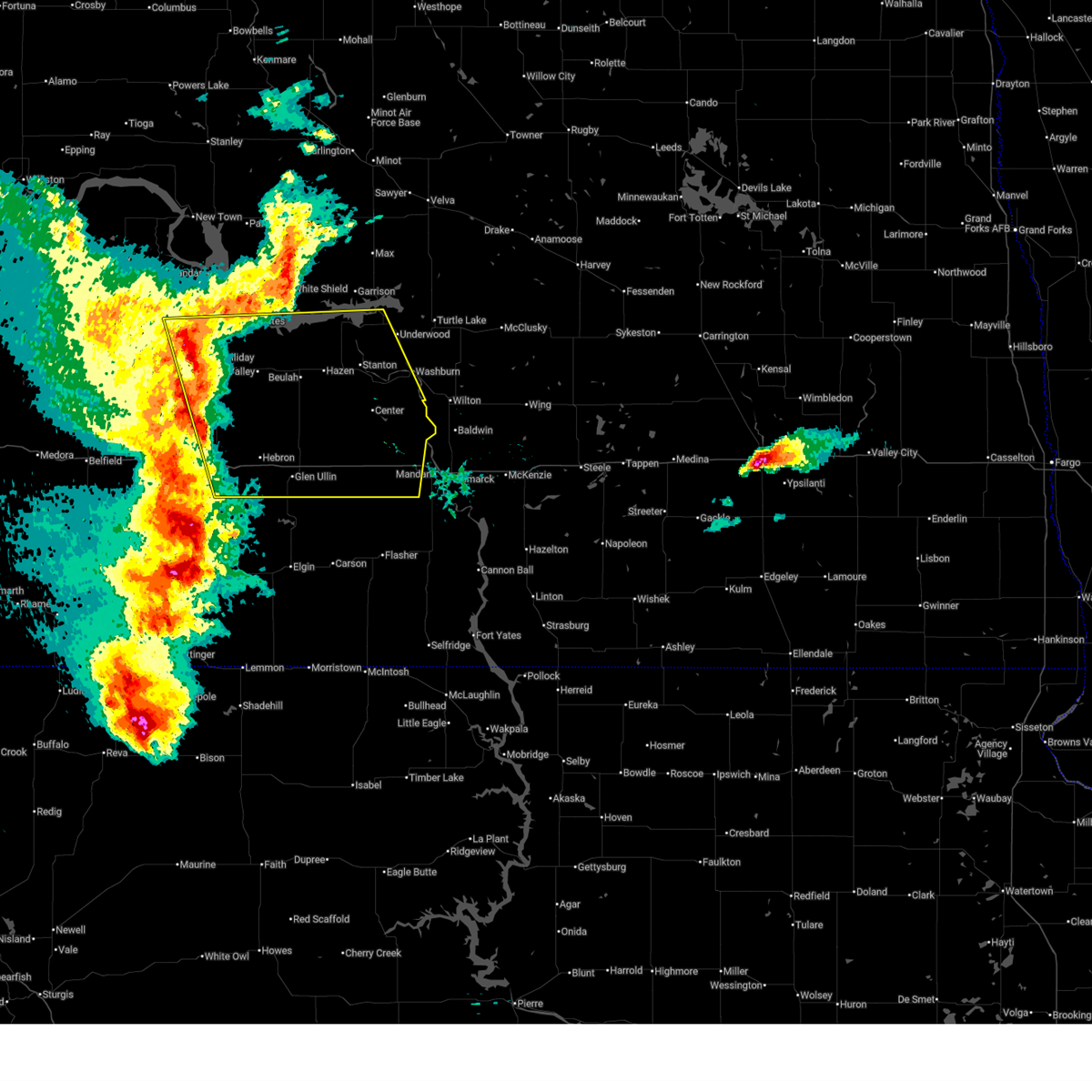
Hail Map for Glen Ullin, ND
The Glen Ullin, ND area has had 30 reports of on-the-ground hail by trained spotters, and has been under severe weather warnings 6 times during the past 12 months. Doppler radar has detected hail at or near Glen Ullin, ND on 58 occasions, including 2 occasions during the past year.
| Name: | Glen Ullin, ND |
| Where Located: | 49.8 miles W of Bismarck, ND |
| Map: | Google Map for Glen Ullin, ND |
| Population: | 807 |
| Housing Units: | 416 |
| More Info: | Search Google for Glen Ullin, ND |
1
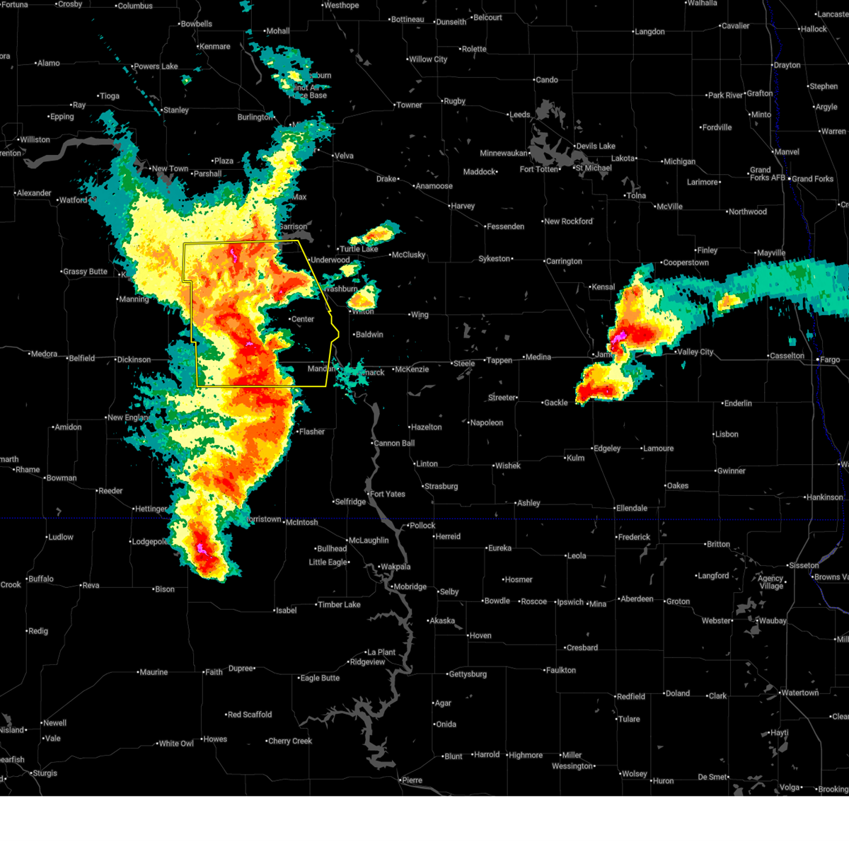
The Top Recent Hail Date for Glen Ullin, ND is Wednesday, June 18, 2025 (14th out of 58)
Hail and Wind Damage Spotted near Glen Ullin, ND
| Date / Time | Report Details |
|---|---|
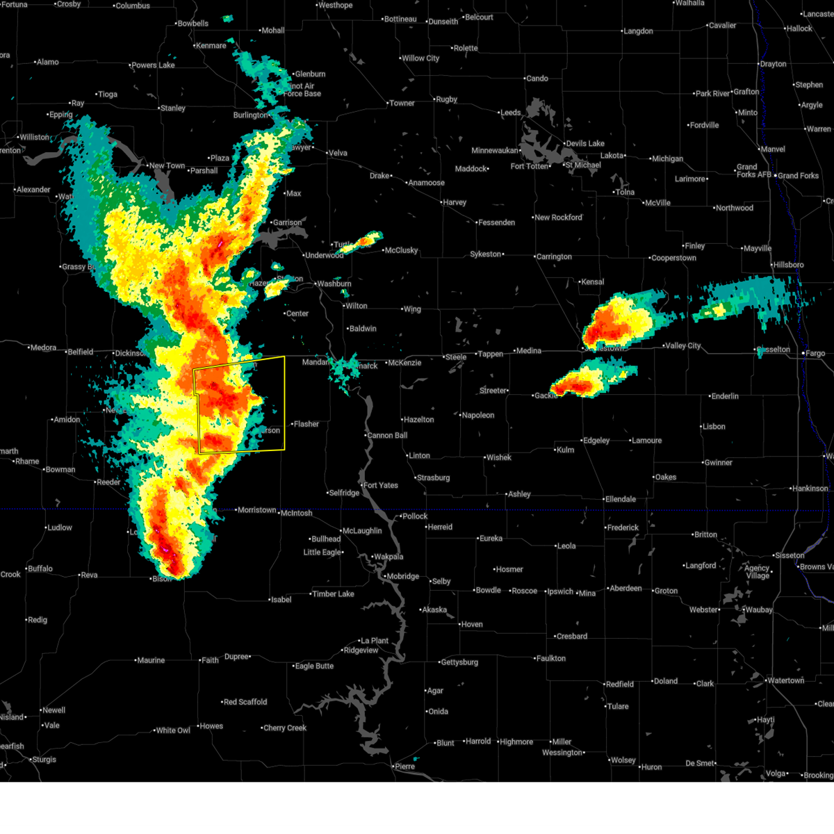
| 6/20/2025 8:42 PM CDT |
 At 842 pm cdt, severe thunderstorms were located along a line extending from 4 miles northwest of hazen to 10 miles northwest of new salem to 8 miles southwest of almont, moving east at 50 mph (radar indicated). Hazards include 70 mph wind gusts and nickel size hail. Expect considerable tree damage. damage is likely to mobile homes, roofs, and outbuildings. Locations impacted include, mandan, beulah, hazen, washburn, new salem, glen ullin, underwood, hebron, center, stanton, zap, riverdale, golden valley, pick city, almont, coleharbor, beulah bay recreation area, hazen bay recreation area, hannover, and judson. At 842 pm cdt, severe thunderstorms were located along a line extending from 4 miles northwest of hazen to 10 miles northwest of new salem to 8 miles southwest of almont, moving east at 50 mph (radar indicated). Hazards include 70 mph wind gusts and nickel size hail. Expect considerable tree damage. damage is likely to mobile homes, roofs, and outbuildings. Locations impacted include, mandan, beulah, hazen, washburn, new salem, glen ullin, underwood, hebron, center, stanton, zap, riverdale, golden valley, pick city, almont, coleharbor, beulah bay recreation area, hazen bay recreation area, hannover, and judson.
|
| 6/20/2025 8:42 PM CDT |
 the severe thunderstorm warning has been cancelled and is no longer in effect the severe thunderstorm warning has been cancelled and is no longer in effect
|
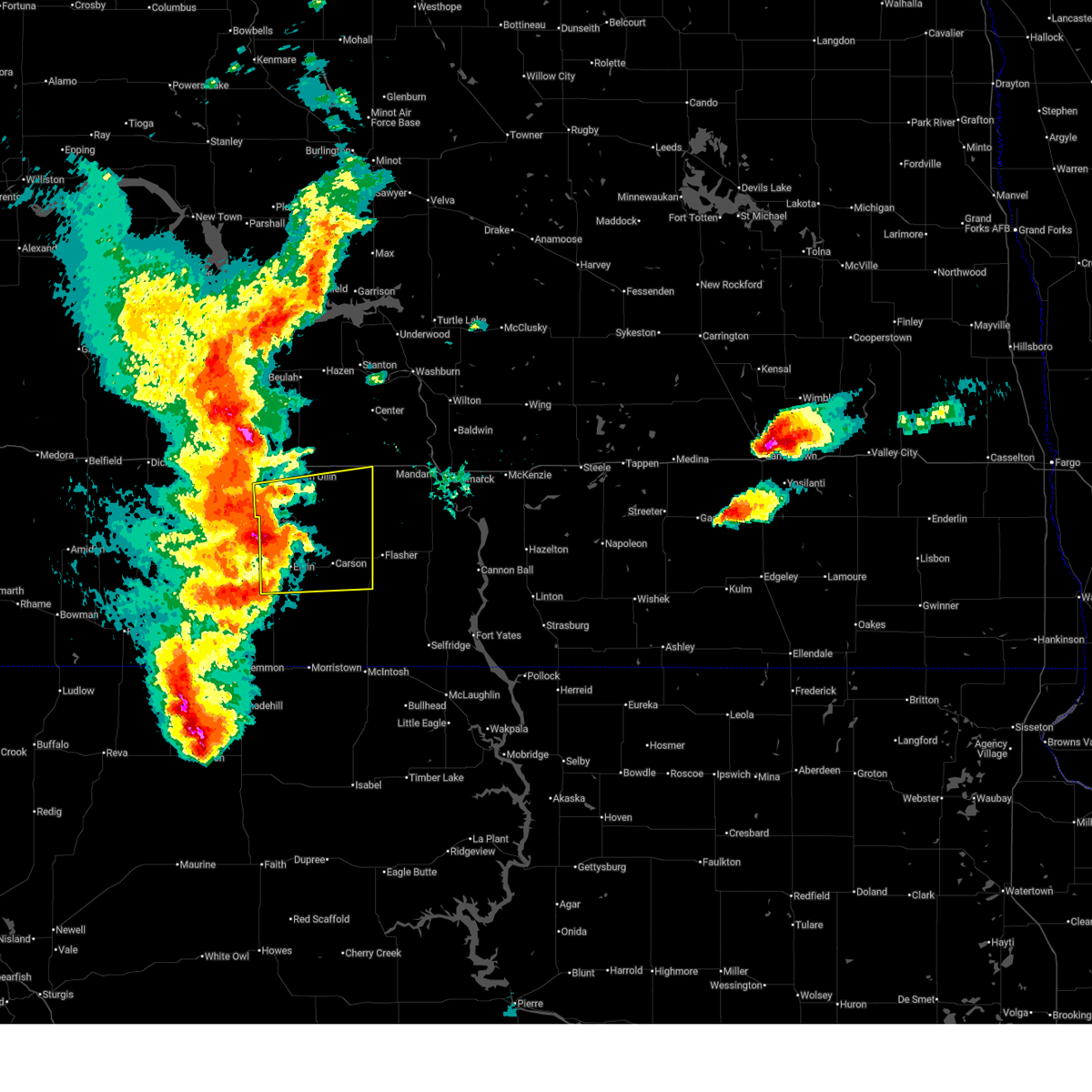
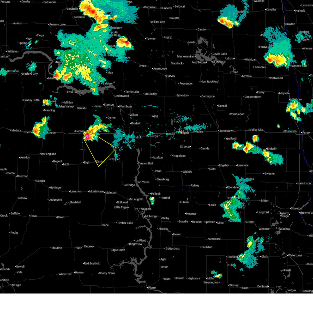
| 6/20/2025 7:31 PM MDT |
 At 830 pm cdt/730 pm mdt/, severe thunderstorms were located along a line extending from near glen ullin to 8 miles south of almont to 9 miles southeast of elgin, moving east at 65 mph. these are destructive storms for grant county (trained weather spotters. at 717 pm mdt, a 94 mph wind gust was reported 10 miles northwest of elgin). Hazards include 90 mph wind gusts. You are in a life-threatening situation. flying debris may be deadly to those caught without shelter. mobile homes will be heavily damaged or destroyed. homes and businesses will have substantial roof and window damage. expect extensive tree damage and power outages. Locations impacted include, new salem, glen ullin, elgin, carson, new leipzig, almont, heart butte dam, lark, raleigh, leith, and heil. At 830 pm cdt/730 pm mdt/, severe thunderstorms were located along a line extending from near glen ullin to 8 miles south of almont to 9 miles southeast of elgin, moving east at 65 mph. these are destructive storms for grant county (trained weather spotters. at 717 pm mdt, a 94 mph wind gust was reported 10 miles northwest of elgin). Hazards include 90 mph wind gusts. You are in a life-threatening situation. flying debris may be deadly to those caught without shelter. mobile homes will be heavily damaged or destroyed. homes and businesses will have substantial roof and window damage. expect extensive tree damage and power outages. Locations impacted include, new salem, glen ullin, elgin, carson, new leipzig, almont, heart butte dam, lark, raleigh, leith, and heil.
|
| 6/20/2025 8:28 PM CDT | Downed cottonwood. relayed via social media with a radar estimated tim in morton county ND, 0.4 miles S of Glen Ullin, ND |
| 6/20/2025 7:20 PM MDT |
 Svrbis the national weather service in bismarck has issued a * severe thunderstorm warning for, northwestern morton county in south central north dakota, northwestern grant county in south central north dakota, * until 845 pm cdt/745 pm mdt/. * at 820 pm cdt/720 pm mdt/, a severe thunderstorm was located near heart butte dam, or 44 miles north of lemmon, moving east at 70 mph. this is a destructive storm for northwest grant county, including heart butte dam (trained weather spotters). Hazards include 90 mph wind gusts. You are in a life-threatening situation. flying debris may be deadly to those caught without shelter. mobile homes will be heavily damaged or destroyed. homes and businesses will have substantial roof and window damage. Expect extensive tree damage and power outages. Svrbis the national weather service in bismarck has issued a * severe thunderstorm warning for, northwestern morton county in south central north dakota, northwestern grant county in south central north dakota, * until 845 pm cdt/745 pm mdt/. * at 820 pm cdt/720 pm mdt/, a severe thunderstorm was located near heart butte dam, or 44 miles north of lemmon, moving east at 70 mph. this is a destructive storm for northwest grant county, including heart butte dam (trained weather spotters). Hazards include 90 mph wind gusts. You are in a life-threatening situation. flying debris may be deadly to those caught without shelter. mobile homes will be heavily damaged or destroyed. homes and businesses will have substantial roof and window damage. Expect extensive tree damage and power outages.
|
| 6/20/2025 8:04 PM CDT |
 Svrbis the national weather service in bismarck has issued a * severe thunderstorm warning for, southeastern dunn county in southwestern north dakota, central mclean county in south central north dakota, northwestern morton county in south central north dakota, northeastern stark county in southwestern north dakota, oliver county in south central north dakota, mercer county in south central north dakota, * until 900 pm cdt/800 pm mdt/. * at 804 pm cdt/704 pm mdt/, severe thunderstorms were located along a line extending from 7 miles north of halliday to 9 miles southeast of marshall to 7 miles south of richardton, moving east at 50 mph (radar indicated). Hazards include 70 mph wind gusts and quarter size hail. Hail damage to vehicles is expected. expect considerable tree damage. Wind damage is also likely to mobile homes, roofs, and outbuildings. Svrbis the national weather service in bismarck has issued a * severe thunderstorm warning for, southeastern dunn county in southwestern north dakota, central mclean county in south central north dakota, northwestern morton county in south central north dakota, northeastern stark county in southwestern north dakota, oliver county in south central north dakota, mercer county in south central north dakota, * until 900 pm cdt/800 pm mdt/. * at 804 pm cdt/704 pm mdt/, severe thunderstorms were located along a line extending from 7 miles north of halliday to 9 miles southeast of marshall to 7 miles south of richardton, moving east at 50 mph (radar indicated). Hazards include 70 mph wind gusts and quarter size hail. Hail damage to vehicles is expected. expect considerable tree damage. Wind damage is also likely to mobile homes, roofs, and outbuildings.
|
| 6/18/2025 7:51 PM CDT |
 Svrbis the national weather service in bismarck has issued a * severe thunderstorm warning for, central morton county in south central north dakota, north central grant county in south central north dakota, * until 845 pm cdt/745 pm mdt/. * at 751 pm cdt/651 pm mdt/, a severe thunderstorm was located 5 miles southeast of glen ullin, or 33 miles south of beulah, moving southeast at 30 mph (radar indicated). Hazards include 60 mph wind gusts and quarter size hail. Hail damage to vehicles is expected. Expect wind damage to roofs, siding, and trees. Svrbis the national weather service in bismarck has issued a * severe thunderstorm warning for, central morton county in south central north dakota, north central grant county in south central north dakota, * until 845 pm cdt/745 pm mdt/. * at 751 pm cdt/651 pm mdt/, a severe thunderstorm was located 5 miles southeast of glen ullin, or 33 miles south of beulah, moving southeast at 30 mph (radar indicated). Hazards include 60 mph wind gusts and quarter size hail. Hail damage to vehicles is expected. Expect wind damage to roofs, siding, and trees.
|
| 6/27/2024 8:39 PM CDT |
 Svrbis the national weather service in bismarck has issued a * severe thunderstorm warning for, northwestern morton county in south central north dakota, oliver county in south central north dakota, southern mercer county in south central north dakota, * until 945 pm cdt. * at 839 pm cdt, severe thunderstorms were located along a line extending from 6 miles east of marshall to 12 miles south of beulah to glen ullin, moving east at 45 mph (radar indicated). Hazards include 70 mph wind gusts. Expect considerable tree damage. Damage is likely to mobile homes, roofs, and outbuildings. Svrbis the national weather service in bismarck has issued a * severe thunderstorm warning for, northwestern morton county in south central north dakota, oliver county in south central north dakota, southern mercer county in south central north dakota, * until 945 pm cdt. * at 839 pm cdt, severe thunderstorms were located along a line extending from 6 miles east of marshall to 12 miles south of beulah to glen ullin, moving east at 45 mph (radar indicated). Hazards include 70 mph wind gusts. Expect considerable tree damage. Damage is likely to mobile homes, roofs, and outbuildings.
|
| 6/27/2024 7:34 PM MDT |
 At 833 pm cdt/733 pm mdt/, severe thunderstorms were located along a line extending from near marshall to 10 miles northeast of hebron to near glen ullin, moving east at 55 mph. these are destructive storms for northeast stark, southeast dunn, southwest morton, and southwest mercer counties (radar indicated). Hazards include 80 mph wind gusts. Flying debris will be dangerous to those caught without shelter. mobile homes will be heavily damaged. expect considerable damage to roofs, windows, and vehicles. extensive tree damage and power outages are likely. Locations impacted include, glen ullin, hebron, zap, golden valley, and marshall. At 833 pm cdt/733 pm mdt/, severe thunderstorms were located along a line extending from near marshall to 10 miles northeast of hebron to near glen ullin, moving east at 55 mph. these are destructive storms for northeast stark, southeast dunn, southwest morton, and southwest mercer counties (radar indicated). Hazards include 80 mph wind gusts. Flying debris will be dangerous to those caught without shelter. mobile homes will be heavily damaged. expect considerable damage to roofs, windows, and vehicles. extensive tree damage and power outages are likely. Locations impacted include, glen ullin, hebron, zap, golden valley, and marshall.
|
| 6/27/2024 7:22 PM MDT |
 At 821 pm cdt/721 pm mdt/, severe thunderstorms were located along a line extending from 7 miles west of marshall to 14 miles northeast of richardton to 4 miles southwest of hebron, moving east at 50 mph. these are destructive storms for northeast stark, southeast dunn, southwest morton, and southwest mercer counties (radar indicated). Hazards include 90 mph wind gusts. You are in a life-threatening situation. flying debris may be deadly to those caught without shelter. mobile homes will be heavily damaged or destroyed. homes and businesses will have substantial roof and window damage. expect extensive tree damage and power outages. Locations impacted include, glen ullin, hebron, richardton, zap, golden valley, taylor, dodge, marshall, and hirschville. At 821 pm cdt/721 pm mdt/, severe thunderstorms were located along a line extending from 7 miles west of marshall to 14 miles northeast of richardton to 4 miles southwest of hebron, moving east at 50 mph. these are destructive storms for northeast stark, southeast dunn, southwest morton, and southwest mercer counties (radar indicated). Hazards include 90 mph wind gusts. You are in a life-threatening situation. flying debris may be deadly to those caught without shelter. mobile homes will be heavily damaged or destroyed. homes and businesses will have substantial roof and window damage. expect extensive tree damage and power outages. Locations impacted include, glen ullin, hebron, richardton, zap, golden valley, taylor, dodge, marshall, and hirschville.
|
| 6/27/2024 7:21 PM MDT |
 At 820 pm cdt/720 pm mdt/, severe thunderstorms were located along a line extending from near hebron to 12 miles west of heart butte dam to near mott, moving east at 55 mph. these are destructive storms (radar indicated). Hazards include 80 mph wind gusts and quarter size hail. Flying debris will be dangerous to those caught without shelter. mobile homes will be heavily damaged. expect considerable damage to roofs, windows, and vehicles. extensive tree damage and power outages are likely. Locations impacted include, new salem, glen ullin, mott, elgin, carson, new leipzig, regent, almont, heart butte dam, burt, leith, heil, and bentley. At 820 pm cdt/720 pm mdt/, severe thunderstorms were located along a line extending from near hebron to 12 miles west of heart butte dam to near mott, moving east at 55 mph. these are destructive storms (radar indicated). Hazards include 80 mph wind gusts and quarter size hail. Flying debris will be dangerous to those caught without shelter. mobile homes will be heavily damaged. expect considerable damage to roofs, windows, and vehicles. extensive tree damage and power outages are likely. Locations impacted include, new salem, glen ullin, mott, elgin, carson, new leipzig, regent, almont, heart butte dam, burt, leith, heil, and bentley.
|
| 6/27/2024 7:05 PM MDT |
 Svrbis the national weather service in bismarck has issued a * severe thunderstorm warning for, southeastern dunn county in southwestern north dakota, northwestern morton county in south central north dakota, northeastern stark county in southwestern north dakota, southwestern mercer county in south central north dakota, * until 845 pm cdt/745 pm mdt/. * at 804 pm cdt/704 pm mdt/, severe thunderstorms were located along a line extending from 9 miles west of marshall to 5 miles north of taylor to 4 miles southwest of richardton, moving northeast at 55 mph. these are destructive storms for northeast stark, southeast dunn, southwest morton, and southwest mercer counties (trained weather spotters. at 648 pm mdt, an 89 mph gust was reported at the dickinson airport). Hazards include 90 mph wind gusts and penny size hail. You are in a life-threatening situation. flying debris may be deadly to those caught without shelter. mobile homes will be heavily damaged or destroyed. homes and businesses will have substantial roof and window damage. Expect extensive tree damage and power outages. Svrbis the national weather service in bismarck has issued a * severe thunderstorm warning for, southeastern dunn county in southwestern north dakota, northwestern morton county in south central north dakota, northeastern stark county in southwestern north dakota, southwestern mercer county in south central north dakota, * until 845 pm cdt/745 pm mdt/. * at 804 pm cdt/704 pm mdt/, severe thunderstorms were located along a line extending from 9 miles west of marshall to 5 miles north of taylor to 4 miles southwest of richardton, moving northeast at 55 mph. these are destructive storms for northeast stark, southeast dunn, southwest morton, and southwest mercer counties (trained weather spotters. at 648 pm mdt, an 89 mph gust was reported at the dickinson airport). Hazards include 90 mph wind gusts and penny size hail. You are in a life-threatening situation. flying debris may be deadly to those caught without shelter. mobile homes will be heavily damaged or destroyed. homes and businesses will have substantial roof and window damage. Expect extensive tree damage and power outages.
|
| 6/27/2024 6:58 PM MDT |
 Svrbis the national weather service in bismarck has issued a * severe thunderstorm warning for, hettinger county in southwestern north dakota, northwestern morton county in south central north dakota, southeastern stark county in southwestern north dakota, northwestern grant county in south central north dakota, * until 900 pm cdt/800 pm mdt/. * at 757 pm cdt/657 pm mdt/, severe thunderstorms were located along a line extending from 5 miles southwest of richardton to 9 miles northeast of regent to 17 miles west of mott, moving east at 55 mph. these are destructive storms (radar indicated). Hazards include 80 mph wind gusts and half dollar size hail. Flying debris will be dangerous to those caught without shelter. mobile homes will be heavily damaged. expect considerable damage to roofs, windows, and vehicles. Extensive tree damage and power outages are likely. Svrbis the national weather service in bismarck has issued a * severe thunderstorm warning for, hettinger county in southwestern north dakota, northwestern morton county in south central north dakota, southeastern stark county in southwestern north dakota, northwestern grant county in south central north dakota, * until 900 pm cdt/800 pm mdt/. * at 757 pm cdt/657 pm mdt/, severe thunderstorms were located along a line extending from 5 miles southwest of richardton to 9 miles northeast of regent to 17 miles west of mott, moving east at 55 mph. these are destructive storms (radar indicated). Hazards include 80 mph wind gusts and half dollar size hail. Flying debris will be dangerous to those caught without shelter. mobile homes will be heavily damaged. expect considerable damage to roofs, windows, and vehicles. Extensive tree damage and power outages are likely.
|
| 6/16/2024 8:24 PM MDT | Ping Pong Ball sized hail reported 13.9 miles NNE of Glen Ullin, ND, facebook report and photos of brief large hail at campgrounds on north side of lake tschida. time estimated based on radar. |
| 6/15/2024 7:30 PM MDT | Golf Ball sized hail reported 13.9 miles NE of Glen Ullin, ND, hail lasted from around 8:30 to 9:00 pm cdt. largest hail was golf ball size. |
| 9/4/2023 7:17 PM CDT | Quarter sized hail reported 8.5 miles SSW of Glen Ullin, ND, wind gusts estimated at 60 mph. |
| 9/4/2023 6:06 PM MDT | 2.00 inches of rain and very small soft hai in mercer county ND, 15.7 miles S of Glen Ullin, ND |
| 9/4/2023 7:00 PM CDT | Quarter sized hail reported 7.5 miles S of Glen Ullin, ND, also estimated 60-70 mph winds with the hail. |
| 9/4/2023 7:00 PM CDT | Also had quarter size hail. event ongoing at time of cal in morton county ND, 7.5 miles S of Glen Ullin, ND |
| 9/4/2023 6:31 PM CDT |
 At 631 pm cdt/531 pm mdt/, a severe thunderstorm was located near hebron, or 30 miles southwest of beulah, moving northeast at 20 mph (radar indicated). Hazards include ping pong ball size hail and 60 mph wind gusts. People and animals outdoors will be injured. expect hail damage to roofs, siding, windows, and vehicles. expect wind damage to roofs, siding, and trees. this severe thunderstorm will be near, hebron around 635 pm cdt. hail threat, radar indicated max hail size, 1. 50 in wind threat, radar indicated max wind gust, 60 mph. At 631 pm cdt/531 pm mdt/, a severe thunderstorm was located near hebron, or 30 miles southwest of beulah, moving northeast at 20 mph (radar indicated). Hazards include ping pong ball size hail and 60 mph wind gusts. People and animals outdoors will be injured. expect hail damage to roofs, siding, windows, and vehicles. expect wind damage to roofs, siding, and trees. this severe thunderstorm will be near, hebron around 635 pm cdt. hail threat, radar indicated max hail size, 1. 50 in wind threat, radar indicated max wind gust, 60 mph.
|
| 8/24/2023 6:08 PM CDT | Estimated 60 mph near the morton mercer county line. winds ongoing at time of warning issuanc in mercer county ND, 11.6 miles S of Glen Ullin, ND |
| 8/24/2023 6:08 PM CDT |
 At 607 pm cdt, severe thunderstorms were located along a line extending from 4 miles east of hazen to 6 miles northwest of hannover to 5 miles northeast of glen ullin, moving east at 50 mph (radar indicated). Hazards include 60 mph wind gusts. Expect damage to roofs, siding, and trees. severe thunderstorms will be near, stanton and hannover around 615 pm cdt. new salem and center around 620 pm cdt. underwood around 625 pm cdt. washburn around 630 pm cdt. turtle lake around 640 pm cdt. wilton and mercer around 650 pm cdt. other locations impacted by these severe thunderstorms include cross ranch state park, price, sweet briar lake, falkirk, crown butte lake, sanger, hensler, fort clark, lake harmon and judson. hail threat, radar indicated max hail size, <. 75 in wind threat, radar indicated max wind gust, 60 mph. At 607 pm cdt, severe thunderstorms were located along a line extending from 4 miles east of hazen to 6 miles northwest of hannover to 5 miles northeast of glen ullin, moving east at 50 mph (radar indicated). Hazards include 60 mph wind gusts. Expect damage to roofs, siding, and trees. severe thunderstorms will be near, stanton and hannover around 615 pm cdt. new salem and center around 620 pm cdt. underwood around 625 pm cdt. washburn around 630 pm cdt. turtle lake around 640 pm cdt. wilton and mercer around 650 pm cdt. other locations impacted by these severe thunderstorms include cross ranch state park, price, sweet briar lake, falkirk, crown butte lake, sanger, hensler, fort clark, lake harmon and judson. hail threat, radar indicated max hail size, <. 75 in wind threat, radar indicated max wind gust, 60 mph.
|
| 8/1/2023 9:12 PM MDT |
 At 1011 pm cdt/911 pm mdt/, severe thunderstorms were located along a line extending from 6 miles north of heart butte dam to 5 miles north of elgin to near new leipzig, moving southeast at 40 mph (radar indicated). Hazards include 70 mph wind gusts and penny size hail. Expect considerable tree damage. damage is likely to mobile homes, roofs, and outbuildings. these severe storms will be near, almont around 1025 pm cdt. carson around 930 pm mdt. other locations impacted by these severe thunderstorms include heil and leith. thunderstorm damage threat, considerable hail threat, radar indicated max hail size, 0. 75 in wind threat, radar indicated max wind gust, 70 mph. At 1011 pm cdt/911 pm mdt/, severe thunderstorms were located along a line extending from 6 miles north of heart butte dam to 5 miles north of elgin to near new leipzig, moving southeast at 40 mph (radar indicated). Hazards include 70 mph wind gusts and penny size hail. Expect considerable tree damage. damage is likely to mobile homes, roofs, and outbuildings. these severe storms will be near, almont around 1025 pm cdt. carson around 930 pm mdt. other locations impacted by these severe thunderstorms include heil and leith. thunderstorm damage threat, considerable hail threat, radar indicated max hail size, 0. 75 in wind threat, radar indicated max wind gust, 70 mph.
|
| 8/1/2023 8:52 PM MDT |
 At 951 pm cdt/851 pm mdt/, severe thunderstorms were located along a line extending from 9 miles south of hebron to 13 miles west of heart butte dam to 8 miles east of mott, moving southeast at 45 mph (radar indicated). Hazards include 70 mph wind gusts and quarter size hail. Hail damage to vehicles is expected. expect considerable tree damage. wind damage is also likely to mobile homes, roofs, and outbuildings. these severe storms will be near, new leipzig around 905 pm mdt. elgin and heart butte dam around 915 pm mdt. carson around 935 pm mdt. other locations impacted by these severe thunderstorms include heil and leith. thunderstorm damage threat, considerable hail threat, radar indicated max hail size, 1. 00 in wind threat, radar indicated max wind gust, 70 mph. At 951 pm cdt/851 pm mdt/, severe thunderstorms were located along a line extending from 9 miles south of hebron to 13 miles west of heart butte dam to 8 miles east of mott, moving southeast at 45 mph (radar indicated). Hazards include 70 mph wind gusts and quarter size hail. Hail damage to vehicles is expected. expect considerable tree damage. wind damage is also likely to mobile homes, roofs, and outbuildings. these severe storms will be near, new leipzig around 905 pm mdt. elgin and heart butte dam around 915 pm mdt. carson around 935 pm mdt. other locations impacted by these severe thunderstorms include heil and leith. thunderstorm damage threat, considerable hail threat, radar indicated max hail size, 1. 00 in wind threat, radar indicated max wind gust, 70 mph.
|
| 8/1/2023 9:39 PM CDT |
 At 938 pm cdt/838 pm mdt/, severe thunderstorms were located along a line extending from 4 miles northwest of hebron to 11 miles southeast of richardton to 15 miles north of mott, moving southeast at 35 mph. these are destructive storms for eastern stark, northeastern hettinger, western morton, and northwestern grant counties (radar indicated). Hazards include 80 mph wind gusts and nickel size hail. Flying debris will be dangerous to those caught without shelter. mobile homes will be heavily damaged. expect considerable damage to roofs, windows, and vehicles. extensive tree damage and power outages are likely. these severe storms will be near, glen ullin around 1005 pm cdt. new leipzig around 910 pm mdt. elgin and heart butte dam around 915 pm mdt. almont around 1030 pm cdt. carson around 935 pm mdt. other locations impacted by these severe thunderstorms include heil and leith. thunderstorm damage threat, destructive hail threat, radar indicated max hail size, 0. 88 in wind threat, radar indicated max wind gust, 80 mph. At 938 pm cdt/838 pm mdt/, severe thunderstorms were located along a line extending from 4 miles northwest of hebron to 11 miles southeast of richardton to 15 miles north of mott, moving southeast at 35 mph. these are destructive storms for eastern stark, northeastern hettinger, western morton, and northwestern grant counties (radar indicated). Hazards include 80 mph wind gusts and nickel size hail. Flying debris will be dangerous to those caught without shelter. mobile homes will be heavily damaged. expect considerable damage to roofs, windows, and vehicles. extensive tree damage and power outages are likely. these severe storms will be near, glen ullin around 1005 pm cdt. new leipzig around 910 pm mdt. elgin and heart butte dam around 915 pm mdt. almont around 1030 pm cdt. carson around 935 pm mdt. other locations impacted by these severe thunderstorms include heil and leith. thunderstorm damage threat, destructive hail threat, radar indicated max hail size, 0. 88 in wind threat, radar indicated max wind gust, 80 mph.
|
| 8/1/2023 8:35 PM MDT |
 At 935 pm cdt/835 pm mdt/, a severe thunderstorm was located 7 miles south of hebron, or 32 miles east of dickinson, moving southeast at 40 mph (radar indicated). Hazards include 70 mph wind gusts and penny size hail. Expect considerable tree damage. damage is likely to mobile homes, roofs, and outbuildings. this severe storm will be near, glen ullin around 950 pm cdt. heart butte dam around 900 pm mdt. almont around 1015 pm cdt. other locations impacted by this severe thunderstorm include heil, lefor, fish creek dam, burt and leith. thunderstorm damage threat, considerable hail threat, radar indicated max hail size, 0. 75 in wind threat, radar indicated max wind gust, 70 mph. At 935 pm cdt/835 pm mdt/, a severe thunderstorm was located 7 miles south of hebron, or 32 miles east of dickinson, moving southeast at 40 mph (radar indicated). Hazards include 70 mph wind gusts and penny size hail. Expect considerable tree damage. damage is likely to mobile homes, roofs, and outbuildings. this severe storm will be near, glen ullin around 950 pm cdt. heart butte dam around 900 pm mdt. almont around 1015 pm cdt. other locations impacted by this severe thunderstorm include heil, lefor, fish creek dam, burt and leith. thunderstorm damage threat, considerable hail threat, radar indicated max hail size, 0. 75 in wind threat, radar indicated max wind gust, 70 mph.
|
| 8/1/2023 9:12 PM CDT |
 At 912 pm cdt/812 pm mdt/, a severe thunderstorm was located over taylor, or 18 miles east of dickinson, moving southeast at 40 mph (radar indicated). Hazards include 70 mph wind gusts and quarter size hail. Hail damage to vehicles is expected. expect considerable tree damage. wind damage is also likely to mobile homes, roofs, and outbuildings. this severe thunderstorm will be near, glen ullin around 950 pm cdt. heart butte dam around 900 pm mdt. almont around 1015 pm cdt. other locations impacted by this severe thunderstorm include heil, lefor, fish creek dam, burt and leith. thunderstorm damage threat, considerable hail threat, radar indicated max hail size, 1. 00 in wind threat, radar indicated max wind gust, 70 mph. At 912 pm cdt/812 pm mdt/, a severe thunderstorm was located over taylor, or 18 miles east of dickinson, moving southeast at 40 mph (radar indicated). Hazards include 70 mph wind gusts and quarter size hail. Hail damage to vehicles is expected. expect considerable tree damage. wind damage is also likely to mobile homes, roofs, and outbuildings. this severe thunderstorm will be near, glen ullin around 950 pm cdt. heart butte dam around 900 pm mdt. almont around 1015 pm cdt. other locations impacted by this severe thunderstorm include heil, lefor, fish creek dam, burt and leith. thunderstorm damage threat, considerable hail threat, radar indicated max hail size, 1. 00 in wind threat, radar indicated max wind gust, 70 mph.
|
| 6/2/2023 3:55 PM CDT | Awos station kd57 glen ulli in morton county ND, 2 miles ESE of Glen Ullin, ND |
| 5/9/2023 5:25 PM MDT | Golf Ball sized hail reported 16.5 miles S of Glen Ullin, ND, public reported pea to golf ball size hail covering the ground. |
| 7/25/2022 10:13 PM CDT |
 The severe thunderstorm warning for southeastern dunn, northern hettinger, northwestern morton, eastern stark, western oliver, mercer and northwestern grant counties will expire at 1015 pm cdt/915 pm mdt/, the storms which prompted the warning have weakened below severe limits, and no longer pose an immediate threat to life or property. therefore, the warning will be allowed to expire. however gusty winds are still possible with these thunderstorms. The severe thunderstorm warning for southeastern dunn, northern hettinger, northwestern morton, eastern stark, western oliver, mercer and northwestern grant counties will expire at 1015 pm cdt/915 pm mdt/, the storms which prompted the warning have weakened below severe limits, and no longer pose an immediate threat to life or property. therefore, the warning will be allowed to expire. however gusty winds are still possible with these thunderstorms.
|
| 7/25/2022 9:52 PM CDT |
 At 951 pm cdt/851 pm mdt/, severe thunderstorms were located along a line extending from near zap to near glen ullin to 5 miles northwest of mott, moving east at 45 mph (radar indicated). Hazards include 60 mph wind gusts. Expect damage to roofs, siding, and trees. locations impacted include, glen ullin, zap, beulah, hazen, new salem, new leipzig, stanton and elgin. hail threat, radar indicated max hail size, <. 75 in wind threat, radar indicated max wind gust, 60 mph. At 951 pm cdt/851 pm mdt/, severe thunderstorms were located along a line extending from near zap to near glen ullin to 5 miles northwest of mott, moving east at 45 mph (radar indicated). Hazards include 60 mph wind gusts. Expect damage to roofs, siding, and trees. locations impacted include, glen ullin, zap, beulah, hazen, new salem, new leipzig, stanton and elgin. hail threat, radar indicated max hail size, <. 75 in wind threat, radar indicated max wind gust, 60 mph.
|
| 7/25/2022 8:24 PM MDT |
 At 923 pm cdt/823 pm mdt/, severe thunderstorms were located along a line extending from 4 miles west of halliday to 4 miles northeast of richardton to near new england, moving east at 50 mph (radar indicated). Hazards include 60 mph wind gusts. Expect damage to roofs, siding, and trees. severe thunderstorms will be near, hebron around 935 pm cdt. dodge around 835 pm mdt. other locations in the path of these severe thunderstorms include golden valley, glen ullin, zap, beulah, hazen, new salem, stanton, elgin and new leipzig. hail threat, radar indicated max hail size, <. 75 in wind threat, radar indicated max wind gust, 60 mph. At 923 pm cdt/823 pm mdt/, severe thunderstorms were located along a line extending from 4 miles west of halliday to 4 miles northeast of richardton to near new england, moving east at 50 mph (radar indicated). Hazards include 60 mph wind gusts. Expect damage to roofs, siding, and trees. severe thunderstorms will be near, hebron around 935 pm cdt. dodge around 835 pm mdt. other locations in the path of these severe thunderstorms include golden valley, glen ullin, zap, beulah, hazen, new salem, stanton, elgin and new leipzig. hail threat, radar indicated max hail size, <. 75 in wind threat, radar indicated max wind gust, 60 mph.
|
| 7/21/2022 4:44 PM CDT |
 At 443 pm cdt, severe thunderstorms were located along a line extending from 6 miles west of hannover to 6 miles east of glen ullin, moving southeast at 40 mph (radar indicated). Hazards include golf ball size hail and 60 mph wind gusts. People and animals outdoors will be injured. expect hail damage to roofs, siding, windows, and vehicles. expect wind damage to roofs, siding, and trees. severe thunderstorms will be near, hannover around 450 pm cdt. new salem, center and almont around 500 pm cdt. other locations in the path of these severe thunderstorms include fish creek dam, lake harmon and mandan. thunderstorm damage threat, considerable hail threat, radar indicated max hail size, 1. 75 in wind threat, radar indicated max wind gust, 60 mph. At 443 pm cdt, severe thunderstorms were located along a line extending from 6 miles west of hannover to 6 miles east of glen ullin, moving southeast at 40 mph (radar indicated). Hazards include golf ball size hail and 60 mph wind gusts. People and animals outdoors will be injured. expect hail damage to roofs, siding, windows, and vehicles. expect wind damage to roofs, siding, and trees. severe thunderstorms will be near, hannover around 450 pm cdt. new salem, center and almont around 500 pm cdt. other locations in the path of these severe thunderstorms include fish creek dam, lake harmon and mandan. thunderstorm damage threat, considerable hail threat, radar indicated max hail size, 1. 75 in wind threat, radar indicated max wind gust, 60 mph.
|
| 7/10/2022 4:03 AM CDT |
 At 402 am cdt/302 am mdt/, a severe thunderstorm was located near glen ullin, moving east at 55 mph (trained weather spotters). Hazards include 70 mph wind gusts and quarter size hail. Hail damage to vehicles is expected. expect considerable tree damage. wind damage is also likely to mobile homes, roofs, and outbuildings. this severe storm will be near, almont around 415 am cdt. new salem around 420 am cdt. thunderstorm damage threat, considerable hail threat, radar indicated max hail size, 1. 00 in wind threat, observed max wind gust, 70 mph. At 402 am cdt/302 am mdt/, a severe thunderstorm was located near glen ullin, moving east at 55 mph (trained weather spotters). Hazards include 70 mph wind gusts and quarter size hail. Hail damage to vehicles is expected. expect considerable tree damage. wind damage is also likely to mobile homes, roofs, and outbuildings. this severe storm will be near, almont around 415 am cdt. new salem around 420 am cdt. thunderstorm damage threat, considerable hail threat, radar indicated max hail size, 1. 00 in wind threat, observed max wind gust, 70 mph.
|
| 7/10/2022 3:39 AM CDT |
 At 338 am cdt/238 am mdt/, a severe thunderstorm was located 5 miles southeast of richardton, or 19 miles west of glen ullin, moving east at 55 mph (radar indicated). Hazards include 70 mph wind gusts and quarter size hail. Hail damage to vehicles is expected. expect considerable tree damage. wind damage is also likely to mobile homes, roofs, and outbuildings. this severe thunderstorm will be near, hebron around 350 am cdt. glen ullin around 400 am cdt. almont around 415 am cdt. new salem around 420 am cdt. thunderstorm damage threat, considerable hail threat, radar indicated max hail size, 1. 00 in wind threat, radar indicated max wind gust, 70 mph. At 338 am cdt/238 am mdt/, a severe thunderstorm was located 5 miles southeast of richardton, or 19 miles west of glen ullin, moving east at 55 mph (radar indicated). Hazards include 70 mph wind gusts and quarter size hail. Hail damage to vehicles is expected. expect considerable tree damage. wind damage is also likely to mobile homes, roofs, and outbuildings. this severe thunderstorm will be near, hebron around 350 am cdt. glen ullin around 400 am cdt. almont around 415 am cdt. new salem around 420 am cdt. thunderstorm damage threat, considerable hail threat, radar indicated max hail size, 1. 00 in wind threat, radar indicated max wind gust, 70 mph.
|
| 7/4/2022 12:40 AM MDT |
 At 139 am cdt/1239 am mdt/, severe thunderstorms were located along a line extending from 12 miles northeast of glen ullin to near carson to keldron, moving east at 45 mph (radar indicated). Hazards include 60 mph wind gusts. Expect damage to roofs, siding, and trees. severe thunderstorms will be near, new salem around 155 am cdt. flasher around 200 am cdt. other locations impacted by these severe thunderstorms include heil, raleigh, st. gertrude, sweet briar lake, porcupine, crown butte lake, breien, leith, lark and judson. hail threat, radar indicated max hail size, <. 75 in wind threat, radar indicated max wind gust, 60 mph. At 139 am cdt/1239 am mdt/, severe thunderstorms were located along a line extending from 12 miles northeast of glen ullin to near carson to keldron, moving east at 45 mph (radar indicated). Hazards include 60 mph wind gusts. Expect damage to roofs, siding, and trees. severe thunderstorms will be near, new salem around 155 am cdt. flasher around 200 am cdt. other locations impacted by these severe thunderstorms include heil, raleigh, st. gertrude, sweet briar lake, porcupine, crown butte lake, breien, leith, lark and judson. hail threat, radar indicated max hail size, <. 75 in wind threat, radar indicated max wind gust, 60 mph.
|
| 7/4/2022 12:31 AM MDT |
 At 131 am cdt/1231 am mdt/, severe thunderstorms were located along a line extending from 11 miles northeast of hebron to 5 miles southeast of elgin to near lemmon, moving east at 40 mph (radar indicated). Hazards include 70 mph wind gusts. Expect considerable tree damage. damage is likely to mobile homes, roofs, and outbuildings. locations impacted include, glen ullin, elgin, hebron, richardton, carson, new leipzig, taylor, heart butte dam, north lemmon, burt, leith, heil and bentley. thunderstorm damage threat, considerable hail threat, radar indicated max hail size, <. 75 in wind threat, radar indicated max wind gust, 70 mph. At 131 am cdt/1231 am mdt/, severe thunderstorms were located along a line extending from 11 miles northeast of hebron to 5 miles southeast of elgin to near lemmon, moving east at 40 mph (radar indicated). Hazards include 70 mph wind gusts. Expect considerable tree damage. damage is likely to mobile homes, roofs, and outbuildings. locations impacted include, glen ullin, elgin, hebron, richardton, carson, new leipzig, taylor, heart butte dam, north lemmon, burt, leith, heil and bentley. thunderstorm damage threat, considerable hail threat, radar indicated max hail size, <. 75 in wind threat, radar indicated max wind gust, 70 mph.
|
| 7/4/2022 12:01 AM MDT |
 At 101 am cdt/1201 am mdt/, severe thunderstorms were located along a line extending from 9 miles northeast of richardton to 8 miles west of new leipzig to 4 miles south of haynes, moving east at 40 mph (radar indicated). Hazards include 70 mph wind gusts. Expect considerable tree damage. damage is likely to mobile homes, roofs, and outbuildings. locations impacted include, hebron, new leipzig, elgin, north lemmon and carson. thunderstorm damage threat, considerable hail threat, radar indicated max hail size, <. 75 in wind threat, radar indicated max wind gust, 70 mph. At 101 am cdt/1201 am mdt/, severe thunderstorms were located along a line extending from 9 miles northeast of richardton to 8 miles west of new leipzig to 4 miles south of haynes, moving east at 40 mph (radar indicated). Hazards include 70 mph wind gusts. Expect considerable tree damage. damage is likely to mobile homes, roofs, and outbuildings. locations impacted include, hebron, new leipzig, elgin, north lemmon and carson. thunderstorm damage threat, considerable hail threat, radar indicated max hail size, <. 75 in wind threat, radar indicated max wind gust, 70 mph.
|
| 7/3/2022 11:39 PM MDT |
 At 1238 am cdt/1138 pm mdt/, severe thunderstorms were located along a line extending from 5 miles northwest of taylor to 4 miles southwest of mott to 7 miles southwest of hettinger, moving east at 40 mph (radar indicated). Hazards include 70 mph wind gusts. Expect considerable tree damage. damage is likely to mobile homes, roofs, and outbuildings. severe thunderstorms will be near, mott around 1145 pm mdt. richardton around 1150 pm mdt. other locations in the path of these severe thunderstorms include haynes, hebron, new leipzig, elgin, north lemmon and carson. thunderstorm damage threat, considerable hail threat, radar indicated max hail size, <. 75 in wind threat, radar indicated max wind gust, 70 mph. At 1238 am cdt/1138 pm mdt/, severe thunderstorms were located along a line extending from 5 miles northwest of taylor to 4 miles southwest of mott to 7 miles southwest of hettinger, moving east at 40 mph (radar indicated). Hazards include 70 mph wind gusts. Expect considerable tree damage. damage is likely to mobile homes, roofs, and outbuildings. severe thunderstorms will be near, mott around 1145 pm mdt. richardton around 1150 pm mdt. other locations in the path of these severe thunderstorms include haynes, hebron, new leipzig, elgin, north lemmon and carson. thunderstorm damage threat, considerable hail threat, radar indicated max hail size, <. 75 in wind threat, radar indicated max wind gust, 70 mph.
|
| 8/30/2021 5:06 PM CDT |
 At 506 pm cdt/406 pm mdt/, a severe thunderstorm was located 7 miles southeast of glen ullin, moving southeast at 10 mph (radar indicated). Hazards include 60 mph wind gusts and half dollar size hail. Hail damage to vehicles is expected. expect wind damage to roofs, siding, and trees. locations impacted include, glen ullin and almont. hail threat, radar indicated max hail size, 1. 25 in wind threat, radar indicated max wind gust, 60 mph. At 506 pm cdt/406 pm mdt/, a severe thunderstorm was located 7 miles southeast of glen ullin, moving southeast at 10 mph (radar indicated). Hazards include 60 mph wind gusts and half dollar size hail. Hail damage to vehicles is expected. expect wind damage to roofs, siding, and trees. locations impacted include, glen ullin and almont. hail threat, radar indicated max hail size, 1. 25 in wind threat, radar indicated max wind gust, 60 mph.
|
| 8/30/2021 4:43 PM CDT |
 At 443 pm cdt/343 pm mdt/, a severe thunderstorm was located near glen ullin, moving southeast at 10 mph (radar indicated). Hazards include ping pong ball size hail and 60 mph wind gusts. People and animals outdoors will be injured. expect hail damage to roofs, siding, windows, and vehicles. Expect wind damage to roofs, siding, and trees. At 443 pm cdt/343 pm mdt/, a severe thunderstorm was located near glen ullin, moving southeast at 10 mph (radar indicated). Hazards include ping pong ball size hail and 60 mph wind gusts. People and animals outdoors will be injured. expect hail damage to roofs, siding, windows, and vehicles. Expect wind damage to roofs, siding, and trees.
|
| 8/30/2021 4:18 PM CDT | Quarter sized hail reported 0.5 miles WNW of Glen Ullin, ND, report from mping: quarter (1.00 in.). |
| 6/11/2021 12:40 AM CDT |
 The severe thunderstorm warning for southeastern dunn, northwestern morton, eastern stark, southwestern mercer and northwestern grant counties will expire at 1245 am cdt/1145 pm mdt/, the storm which prompted the warning has moved out of the area. therefore, the warning will be allowed to expire. however gusty winds are still possible with this thunderstorm. a severe thunderstorm watch remains in effect until 300 am cdt/200 am mdt/ for south central and southwestern north dakota. The severe thunderstorm warning for southeastern dunn, northwestern morton, eastern stark, southwestern mercer and northwestern grant counties will expire at 1245 am cdt/1145 pm mdt/, the storm which prompted the warning has moved out of the area. therefore, the warning will be allowed to expire. however gusty winds are still possible with this thunderstorm. a severe thunderstorm watch remains in effect until 300 am cdt/200 am mdt/ for south central and southwestern north dakota.
|
| 6/11/2021 12:31 AM CDT | Half Dollar sized hail reported 11.6 miles S of Glen Ullin, ND, report from mping: half dollar (1.25 in.). |
| 6/11/2021 12:26 AM CDT |
 At 1224 am cdt/1124 pm mdt/, a severe thunderstorm was located near hebron, or 7 miles northwest of glen ullin, moving northeast at 55 mph (trained weather spotters near richardton have reported wind gusts near 60 mph and hail the size of quarters. strong winds over 60 mph were also observed at glen ullin). Hazards include 70 mph wind gusts and quarter size hail. Hail damage to vehicles is expected. expect considerable tree damage. wind damage is also likely to mobile homes, roofs, and outbuildings. Locations impacted include, glen ullin, hebron, richardton, taylor, marshall and lefor. At 1224 am cdt/1124 pm mdt/, a severe thunderstorm was located near hebron, or 7 miles northwest of glen ullin, moving northeast at 55 mph (trained weather spotters near richardton have reported wind gusts near 60 mph and hail the size of quarters. strong winds over 60 mph were also observed at glen ullin). Hazards include 70 mph wind gusts and quarter size hail. Hail damage to vehicles is expected. expect considerable tree damage. wind damage is also likely to mobile homes, roofs, and outbuildings. Locations impacted include, glen ullin, hebron, richardton, taylor, marshall and lefor.
|
| 6/10/2021 11:21 PM MDT |
 At 1221 am cdt/1121 pm mdt/, severe thunderstorms were located along a line extending from 6 miles south of glen ullin to carson to keldron, moving east at 20 mph (radar indicated). Hazards include 70 mph wind gusts and nickel size hail. Expect considerable tree damage. damage is likely to mobile homes, roofs, and outbuildings. severe thunderstorms will be near, carson around 1125 pm mdt. Other locations in the path of these severe thunderstorms include flasher, almont and new salem. At 1221 am cdt/1121 pm mdt/, severe thunderstorms were located along a line extending from 6 miles south of glen ullin to carson to keldron, moving east at 20 mph (radar indicated). Hazards include 70 mph wind gusts and nickel size hail. Expect considerable tree damage. damage is likely to mobile homes, roofs, and outbuildings. severe thunderstorms will be near, carson around 1125 pm mdt. Other locations in the path of these severe thunderstorms include flasher, almont and new salem.
|
| 6/11/2021 12:20 AM CDT | 5 inch tree trunk broken. picture relayed via social medi in morton county ND, 0.4 miles S of Glen Ullin, ND |
| 6/10/2021 11:09 PM MDT |
 At 1208 am cdt/1108 pm mdt/, a severe thunderstorm was located 14 miles south of hebron, or 16 miles southwest of glen ullin, moving northeast at 55 mph (trained weather spotters near richardton have reported wind gusts near 75 mph and hail the size of quarters). Hazards include 70 mph wind gusts and quarter size hail. Hail damage to vehicles is expected. expect considerable tree damage. wind damage is also likely to mobile homes, roofs, and outbuildings. Locations impacted include, glen ullin, hebron, richardton, taylor, marshall and lefor. At 1208 am cdt/1108 pm mdt/, a severe thunderstorm was located 14 miles south of hebron, or 16 miles southwest of glen ullin, moving northeast at 55 mph (trained weather spotters near richardton have reported wind gusts near 75 mph and hail the size of quarters). Hazards include 70 mph wind gusts and quarter size hail. Hail damage to vehicles is expected. expect considerable tree damage. wind damage is also likely to mobile homes, roofs, and outbuildings. Locations impacted include, glen ullin, hebron, richardton, taylor, marshall and lefor.
|
| 6/10/2021 10:59 PM MDT |
 At 1159 pm cdt/1059 pm mdt/, a severe thunderstorm was located 15 miles north of mott, moving northeast at 55 mph (trained weather spotters near richardton have reported wind gusts near 60 mph and hail the size of quarters). Hazards include 60 mph wind gusts and quarter size hail. Hail damage to vehicles is expected. expect wind damage to roofs, siding, and trees. Locations impacted include, glen ullin, mott, hebron, richardton, regent, taylor, marshall, burt and lefor. At 1159 pm cdt/1059 pm mdt/, a severe thunderstorm was located 15 miles north of mott, moving northeast at 55 mph (trained weather spotters near richardton have reported wind gusts near 60 mph and hail the size of quarters). Hazards include 60 mph wind gusts and quarter size hail. Hail damage to vehicles is expected. expect wind damage to roofs, siding, and trees. Locations impacted include, glen ullin, mott, hebron, richardton, regent, taylor, marshall, burt and lefor.
|
| 6/10/2021 10:51 PM MDT |
 At 1150 pm cdt/1050 pm mdt/, a severe thunderstorm was located 7 miles north of mott, moving northeast at 55 mph (radar indicated). Hazards include 60 mph wind gusts and quarter size hail. Hail damage to vehicles is expected. Expect wind damage to roofs, siding, and trees. At 1150 pm cdt/1050 pm mdt/, a severe thunderstorm was located 7 miles north of mott, moving northeast at 55 mph (radar indicated). Hazards include 60 mph wind gusts and quarter size hail. Hail damage to vehicles is expected. Expect wind damage to roofs, siding, and trees.
|
| 6/8/2021 11:55 PM MDT |
 At 1244 am cdt/1144 pm mdt/, severe thunderstorms were located along a line extending from 4 miles east of glen ullin to new leipzig, moving east at 30 mph (radar indicated). Hazards include 60 mph wind gusts. Expect damage to roofs, siding, and trees. Locations impacted include, glen ullin, elgin, new leipzig, heart butte dam, burt and bentley. At 1244 am cdt/1144 pm mdt/, severe thunderstorms were located along a line extending from 4 miles east of glen ullin to new leipzig, moving east at 30 mph (radar indicated). Hazards include 60 mph wind gusts. Expect damage to roofs, siding, and trees. Locations impacted include, glen ullin, elgin, new leipzig, heart butte dam, burt and bentley.
|
| 6/8/2021 11:45 PM MDT |
 At 1244 am cdt/1144 pm mdt/, severe thunderstorms were located along a line extending from 4 miles east of glen ullin to new leipzig, moving east at 30 mph (radar indicated). Hazards include 60 mph wind gusts. Expect damage to roofs, siding, and trees. Locations impacted include, glen ullin, elgin, new leipzig, heart butte dam, burt and bentley. At 1244 am cdt/1144 pm mdt/, severe thunderstorms were located along a line extending from 4 miles east of glen ullin to new leipzig, moving east at 30 mph (radar indicated). Hazards include 60 mph wind gusts. Expect damage to roofs, siding, and trees. Locations impacted include, glen ullin, elgin, new leipzig, heart butte dam, burt and bentley.
|
| 6/8/2021 11:25 PM MDT |
 At 1224 am cdt/1124 pm mdt/, severe thunderstorms were located along a line extending from 5 miles west of glen ullin to 8 miles west of new leipzig, moving east at 30 mph (radar indicated). Hazards include 60 mph wind gusts and penny size hail. Expect damage to roofs, siding, and trees. Locations impacted include, glen ullin and elgin. At 1224 am cdt/1124 pm mdt/, severe thunderstorms were located along a line extending from 5 miles west of glen ullin to 8 miles west of new leipzig, moving east at 30 mph (radar indicated). Hazards include 60 mph wind gusts and penny size hail. Expect damage to roofs, siding, and trees. Locations impacted include, glen ullin and elgin.
|
| 6/8/2021 11:01 PM MDT |
 At 1201 am cdt/1101 pm mdt/, severe thunderstorms were located along a line extending from 7 miles southeast of richardton to near mott, moving east at 30 mph (radar indicated). Hazards include 60 mph wind gusts and penny size hail. Expect damage to roofs, siding, and trees. severe thunderstorms will be near, hebron around 1120 pm mdt. Other locations in the path of these severe thunderstorms include glen ullin, new leipzig and elgin. At 1201 am cdt/1101 pm mdt/, severe thunderstorms were located along a line extending from 7 miles southeast of richardton to near mott, moving east at 30 mph (radar indicated). Hazards include 60 mph wind gusts and penny size hail. Expect damage to roofs, siding, and trees. severe thunderstorms will be near, hebron around 1120 pm mdt. Other locations in the path of these severe thunderstorms include glen ullin, new leipzig and elgin.
|
| 5/23/2021 8:47 PM CDT |
 At 847 pm cdt/747 pm mdt/, a severe thunderstorm was located near hebron, or 9 miles west of glen ullin, moving north at 35 mph (radar indicated). Hazards include 60 mph wind gusts and quarter size hail. Hail damage to vehicles is expected. expect wind damage to roofs, siding, and trees. Locations impacted include, hebron. At 847 pm cdt/747 pm mdt/, a severe thunderstorm was located near hebron, or 9 miles west of glen ullin, moving north at 35 mph (radar indicated). Hazards include 60 mph wind gusts and quarter size hail. Hail damage to vehicles is expected. expect wind damage to roofs, siding, and trees. Locations impacted include, hebron.
|
| 5/23/2021 8:31 PM CDT |
 At 831 pm cdt/731 pm mdt/, a severe thunderstorm was located 13 miles southwest of glen ullin, moving north at 35 mph (radar indicated). Hazards include 60 mph wind gusts and quarter size hail. Hail damage to vehicles is expected. expect wind damage to roofs, siding, and trees. This severe thunderstorm will be near, hebron around 855 pm cdt. At 831 pm cdt/731 pm mdt/, a severe thunderstorm was located 13 miles southwest of glen ullin, moving north at 35 mph (radar indicated). Hazards include 60 mph wind gusts and quarter size hail. Hail damage to vehicles is expected. expect wind damage to roofs, siding, and trees. This severe thunderstorm will be near, hebron around 855 pm cdt.
|
| 8/27/2020 7:13 PM MDT | Golf Ball sized hail reported 13.8 miles NNE of Glen Ullin, ND, relayed via broadcast media. |
| 7/7/2020 10:44 PM CDT |
 At 1043 pm cdt, severe thunderstorms capable of producing tornadoes were located along a line extending from 6 miles northeast of hebron to 6 miles south of glen ullin, moving northeast at 55 mph (radar indicated rotation). Hazards include tornado and half dollar size hail. Flying debris will be dangerous to those caught without shelter. mobile homes will be damaged or destroyed. damage to roofs, windows, and vehicles will occur. tree damage is likely. Locations impacted include, glen ullin, hebron and almont. At 1043 pm cdt, severe thunderstorms capable of producing tornadoes were located along a line extending from 6 miles northeast of hebron to 6 miles south of glen ullin, moving northeast at 55 mph (radar indicated rotation). Hazards include tornado and half dollar size hail. Flying debris will be dangerous to those caught without shelter. mobile homes will be damaged or destroyed. damage to roofs, windows, and vehicles will occur. tree damage is likely. Locations impacted include, glen ullin, hebron and almont.
|
| 7/7/2020 9:39 PM MDT |
 At 1039 pm cdt/939 pm mdt/, severe thunderstorms were located along a line extending from 5 miles northeast of manning to 9 miles east of marshall to 10 miles southwest of glen ullin to 9 miles south of mott, moving northeast at 55 mph. these are very dangerous storms (radar indicated). Hazards include 80 mph wind gusts and half dollar size hail. Flying debris will be dangerous to those caught without shelter. mobile homes will be heavily damaged. expect considerable damage to roofs, windows, and vehicles. extensive tree damage and power outages are likely. these severe storms will be near, glen ullin around 1050 pm cdt. zap and halliday around 1055 pm cdt. beulah and new leipzig around 1100 pm cdt. elgin and hazen around 1110 pm cdt. Other locations impacted by these severe thunderstorms include heil, twin buttes, hirschville, burt, bentley, lefor and new hradec. At 1039 pm cdt/939 pm mdt/, severe thunderstorms were located along a line extending from 5 miles northeast of manning to 9 miles east of marshall to 10 miles southwest of glen ullin to 9 miles south of mott, moving northeast at 55 mph. these are very dangerous storms (radar indicated). Hazards include 80 mph wind gusts and half dollar size hail. Flying debris will be dangerous to those caught without shelter. mobile homes will be heavily damaged. expect considerable damage to roofs, windows, and vehicles. extensive tree damage and power outages are likely. these severe storms will be near, glen ullin around 1050 pm cdt. zap and halliday around 1055 pm cdt. beulah and new leipzig around 1100 pm cdt. elgin and hazen around 1110 pm cdt. Other locations impacted by these severe thunderstorms include heil, twin buttes, hirschville, burt, bentley, lefor and new hradec.
|
| 7/7/2020 10:34 PM CDT |
 At 1034 pm cdt/934 pm mdt/, a severe thunderstorm capable of producing a tornado was located over hebron, or 11 miles west of glen ullin, moving northeast at 55 mph (radar indicated rotation). Hazards include tornado and half dollar size hail. Flying debris will be dangerous to those caught without shelter. mobile homes will be damaged or destroyed. damage to roofs, windows, and vehicles will occur. tree damage is likely. This tornadic thunderstorm will remain over mainly rural areas of northwestern morton, east central stark, southwestern oliver and south central mercer counties. At 1034 pm cdt/934 pm mdt/, a severe thunderstorm capable of producing a tornado was located over hebron, or 11 miles west of glen ullin, moving northeast at 55 mph (radar indicated rotation). Hazards include tornado and half dollar size hail. Flying debris will be dangerous to those caught without shelter. mobile homes will be damaged or destroyed. damage to roofs, windows, and vehicles will occur. tree damage is likely. This tornadic thunderstorm will remain over mainly rural areas of northwestern morton, east central stark, southwestern oliver and south central mercer counties.
|
| 7/7/2020 9:13 PM MDT |
 At 1013 pm cdt/913 pm mdt/, severe thunderstorms were located along a line extending from 8 miles east of south fairfield to 5 miles north of gladstone to 10 miles northeast of regent to 7 miles northeast of reeder, moving northeast at 50 mph. these are very dangerous storms (radar indicated). Hazards include 80 mph wind gusts and half dollar size hail. Flying debris will be dangerous to those caught without shelter. mobile homes will be heavily damaged. expect considerable damage to roofs, windows, and vehicles. extensive tree damage and power outages are likely. severe thunderstorms will be near, taylor around 920 pm mdt. manning and marshall around 935 pm mdt. regent around 940 pm mdt. dunn center around 945 pm mdt. mott around 950 pm mdt. glen ullin and golden valley around 1055 pm cdt. zap and halliday around 1100 pm cdt. dodge around 1105 pm cdt. Other locations impacted by these severe thunderstorms include heil, twin buttes, hirschville, burt, bentley, lefor and new hradec. At 1013 pm cdt/913 pm mdt/, severe thunderstorms were located along a line extending from 8 miles east of south fairfield to 5 miles north of gladstone to 10 miles northeast of regent to 7 miles northeast of reeder, moving northeast at 50 mph. these are very dangerous storms (radar indicated). Hazards include 80 mph wind gusts and half dollar size hail. Flying debris will be dangerous to those caught without shelter. mobile homes will be heavily damaged. expect considerable damage to roofs, windows, and vehicles. extensive tree damage and power outages are likely. severe thunderstorms will be near, taylor around 920 pm mdt. manning and marshall around 935 pm mdt. regent around 940 pm mdt. dunn center around 945 pm mdt. mott around 950 pm mdt. glen ullin and golden valley around 1055 pm cdt. zap and halliday around 1100 pm cdt. dodge around 1105 pm cdt. Other locations impacted by these severe thunderstorms include heil, twin buttes, hirschville, burt, bentley, lefor and new hradec.
|
| 6/16/2020 10:53 PM CDT |
 At 1052 pm cdt, severe thunderstorms were located along a line extending from 9 miles northwest of new salem to 4 miles west of almont, moving northeast at 30 mph (trained weather spotters. at 1047 pm cdt, quarter size hail was reported 8 miles east-northeast of glen ullin). Hazards include 60 mph wind gusts and quarter size hail. Hail damage to vehicles is expected. expect wind damage to roofs, siding, and trees. These severe storms will be near, new salem around 1115 pm cdt. At 1052 pm cdt, severe thunderstorms were located along a line extending from 9 miles northwest of new salem to 4 miles west of almont, moving northeast at 30 mph (trained weather spotters. at 1047 pm cdt, quarter size hail was reported 8 miles east-northeast of glen ullin). Hazards include 60 mph wind gusts and quarter size hail. Hail damage to vehicles is expected. expect wind damage to roofs, siding, and trees. These severe storms will be near, new salem around 1115 pm cdt.
|
| 6/16/2020 10:47 PM CDT | Quarter sized hail reported 8.2 miles WSW of Glen Ullin, ND, storm spotter |
| 6/16/2020 10:41 PM CDT |
 At 1041 pm cdt/941 pm mdt/, severe thunderstorms were located along a line extending from 9 miles east of glen ullin to 7 miles southwest of almont, moving northeast at 35 mph (radar indicated). Hazards include 60 mph wind gusts and half dollar size hail. Hail damage to vehicles is expected. expect wind damage to roofs, siding, and trees. these severe storms will be near, almont around 1050 pm cdt. New salem around 1110 pm cdt. At 1041 pm cdt/941 pm mdt/, severe thunderstorms were located along a line extending from 9 miles east of glen ullin to 7 miles southwest of almont, moving northeast at 35 mph (radar indicated). Hazards include 60 mph wind gusts and half dollar size hail. Hail damage to vehicles is expected. expect wind damage to roofs, siding, and trees. these severe storms will be near, almont around 1050 pm cdt. New salem around 1110 pm cdt.
|
| 6/16/2020 10:26 PM CDT |
 At 1026 pm cdt/926 pm mdt/, severe thunderstorms were located along a line extending from 7 miles southeast of glen ullin to 4 miles southeast of heart butte dam, moving northeast at 30 mph (radar indicated). Hazards include 60 mph wind gusts and quarter size hail. Hail damage to vehicles is expected. expect wind damage to roofs, siding, and trees. severe thunderstorms will be near, glen ullin around 1035 pm cdt. almont around 1100 pm cdt. New salem around 1120 pm cdt. At 1026 pm cdt/926 pm mdt/, severe thunderstorms were located along a line extending from 7 miles southeast of glen ullin to 4 miles southeast of heart butte dam, moving northeast at 30 mph (radar indicated). Hazards include 60 mph wind gusts and quarter size hail. Hail damage to vehicles is expected. expect wind damage to roofs, siding, and trees. severe thunderstorms will be near, glen ullin around 1035 pm cdt. almont around 1100 pm cdt. New salem around 1120 pm cdt.
|
| 6/7/2020 9:15 PM CDT |
 At 914 pm cdt/814 pm mdt/, a severe thunderstorm was located 6 miles north of heart butte dam, or 9 miles south of glen ullin, moving northeast at 35 mph (radar indicated). Hazards include 60 mph wind gusts and quarter size hail. Hail damage to vehicles is expected. expect wind damage to roofs, siding, and trees. Locations impacted include, glen ullin and almont. At 914 pm cdt/814 pm mdt/, a severe thunderstorm was located 6 miles north of heart butte dam, or 9 miles south of glen ullin, moving northeast at 35 mph (radar indicated). Hazards include 60 mph wind gusts and quarter size hail. Hail damage to vehicles is expected. expect wind damage to roofs, siding, and trees. Locations impacted include, glen ullin and almont.
|
| 6/7/2020 8:00 PM MDT |
 At 900 pm cdt/800 pm mdt/, a severe thunderstorm was located 5 miles northwest of heart butte dam, or 12 miles south of glen ullin, moving northeast at 30 mph (radar indicated). Hazards include 60 mph wind gusts and half dollar size hail. Hail damage to vehicles is expected. expect wind damage to roofs, siding, and trees. Locations impacted include, glen ullin, almont and heart butte dam. At 900 pm cdt/800 pm mdt/, a severe thunderstorm was located 5 miles northwest of heart butte dam, or 12 miles south of glen ullin, moving northeast at 30 mph (radar indicated). Hazards include 60 mph wind gusts and half dollar size hail. Hail damage to vehicles is expected. expect wind damage to roofs, siding, and trees. Locations impacted include, glen ullin, almont and heart butte dam.
|
| 6/7/2020 7:45 PM MDT |
 At 844 pm cdt/744 pm mdt/, a severe thunderstorm was located 10 miles west of heart butte dam, or 13 miles northwest of elgin, moving northeast at 35 mph (radar indicated). Hazards include ping pong ball size hail and 60 mph wind gusts. People and animals outdoors will be injured. expect hail damage to roofs, siding, windows, and vehicles. expect wind damage to roofs, siding, and trees. Locations impacted include, glen ullin, hebron, almont and heart butte dam. At 844 pm cdt/744 pm mdt/, a severe thunderstorm was located 10 miles west of heart butte dam, or 13 miles northwest of elgin, moving northeast at 35 mph (radar indicated). Hazards include ping pong ball size hail and 60 mph wind gusts. People and animals outdoors will be injured. expect hail damage to roofs, siding, windows, and vehicles. expect wind damage to roofs, siding, and trees. Locations impacted include, glen ullin, hebron, almont and heart butte dam.
|
| 6/7/2020 7:26 PM MDT |
 At 826 pm cdt/726 pm mdt/, a severe thunderstorm was located 10 miles northeast of mott, moving northeast at 30 mph (radar indicated). Hazards include ping pong ball size hail and 60 mph wind gusts. People and animals outdoors will be injured. expect hail damage to roofs, siding, windows, and vehicles. expect wind damage to roofs, siding, and trees. this severe thunderstorm will be near, glen ullin around 930 pm cdt. Other locations impacted by this severe thunderstorm include burt. At 826 pm cdt/726 pm mdt/, a severe thunderstorm was located 10 miles northeast of mott, moving northeast at 30 mph (radar indicated). Hazards include ping pong ball size hail and 60 mph wind gusts. People and animals outdoors will be injured. expect hail damage to roofs, siding, windows, and vehicles. expect wind damage to roofs, siding, and trees. this severe thunderstorm will be near, glen ullin around 930 pm cdt. Other locations impacted by this severe thunderstorm include burt.
|
| 6/6/2020 10:57 PM CDT |
 At 1056 pm cdt/956 pm mdt/, severe thunderstorms were located along a line extending from 6 miles southwest of new salem to 8 miles north of flasher to 9 miles northeast of shields, moving northeast at 50 mph (radar indicated). Hazards include 60 mph wind gusts. Expect damage to roofs, siding, and trees. these severe storms will be near, solen and st. anthony around 1110 pm cdt. other locations impacted by these severe thunderstorms include heil, st. Gertrude, raleigh, sweet briar lake, porcupine, breien, leith, lark and judson. At 1056 pm cdt/956 pm mdt/, severe thunderstorms were located along a line extending from 6 miles southwest of new salem to 8 miles north of flasher to 9 miles northeast of shields, moving northeast at 50 mph (radar indicated). Hazards include 60 mph wind gusts. Expect damage to roofs, siding, and trees. these severe storms will be near, solen and st. anthony around 1110 pm cdt. other locations impacted by these severe thunderstorms include heil, st. Gertrude, raleigh, sweet briar lake, porcupine, breien, leith, lark and judson.
|
| 6/6/2020 9:39 PM MDT |
 At 1039 pm cdt/939 pm mdt/, severe thunderstorms were located along a line extending from 7 miles north of heart butte dam to 6 miles northeast of carson to 6 miles west of shields, moving northeast at 45 mph (radar indicated). Hazards include 60 mph wind gusts. Expect damage to roofs, siding, and trees. these severe storms will be near, shields around 945 pm mdt. flasher around 950 pm mdt. new salem and fish creek dam around 1105 pm cdt. solen around 1110 pm cdt. st. anthony around 1120 pm cdt. other locations impacted by these severe thunderstorms include heil, st. Gertrude, raleigh, sweet briar lake, porcupine, breien, leith, lark and judson. At 1039 pm cdt/939 pm mdt/, severe thunderstorms were located along a line extending from 7 miles north of heart butte dam to 6 miles northeast of carson to 6 miles west of shields, moving northeast at 45 mph (radar indicated). Hazards include 60 mph wind gusts. Expect damage to roofs, siding, and trees. these severe storms will be near, shields around 945 pm mdt. flasher around 950 pm mdt. new salem and fish creek dam around 1105 pm cdt. solen around 1110 pm cdt. st. anthony around 1120 pm cdt. other locations impacted by these severe thunderstorms include heil, st. Gertrude, raleigh, sweet briar lake, porcupine, breien, leith, lark and judson.
|
| 6/6/2020 9:24 PM MDT |
 At 1021 pm cdt/921 pm mdt/, severe thunderstorms were located along a line extending from 9 miles west of heart butte dam to 5 miles southwest of carson to 12 miles north of watauga, moving northeast at 60 mph (radar indicated). Hazards include 70 mph wind gusts. Expect considerable tree damage. damage is likely to mobile homes, roofs, and outbuildings. severe thunderstorms will be near, carson around 925 pm mdt. heart butte dam around 930 pm mdt. glen ullin, flasher and shields around 940 pm mdt. almont around 945 pm mdt. new salem and fish creek dam around 1055 pm cdt. solen around 1100 pm cdt. other locations impacted by these severe thunderstorms include heil, st. Gertrude, raleigh, sweet briar lake, porcupine, breien, leith, lark and judson. At 1021 pm cdt/921 pm mdt/, severe thunderstorms were located along a line extending from 9 miles west of heart butte dam to 5 miles southwest of carson to 12 miles north of watauga, moving northeast at 60 mph (radar indicated). Hazards include 70 mph wind gusts. Expect considerable tree damage. damage is likely to mobile homes, roofs, and outbuildings. severe thunderstorms will be near, carson around 925 pm mdt. heart butte dam around 930 pm mdt. glen ullin, flasher and shields around 940 pm mdt. almont around 945 pm mdt. new salem and fish creek dam around 1055 pm cdt. solen around 1100 pm cdt. other locations impacted by these severe thunderstorms include heil, st. Gertrude, raleigh, sweet briar lake, porcupine, breien, leith, lark and judson.
|
| 3/4/2020 2:56 PM MST |
 The severe thunderstorm warning for eastern hettinger, morton, southeastern stark and grant counties will expire at 400 pm cst/300 pm mst/, the storms which prompted the warning have weakened below severe limits. therefore, the warning will be allowed to expire. however, strong and gusty winds are still possible with this line of showers. wind gusts of 50 to 55 mph are likely until 6 pm cst across south central north dakota. The severe thunderstorm warning for eastern hettinger, morton, southeastern stark and grant counties will expire at 400 pm cst/300 pm mst/, the storms which prompted the warning have weakened below severe limits. therefore, the warning will be allowed to expire. however, strong and gusty winds are still possible with this line of showers. wind gusts of 50 to 55 mph are likely until 6 pm cst across south central north dakota.
|
| 3/4/2020 2:32 PM MST |
 At 331 pm cst/231 pm mst/, severe thunderstorms were located along a line extending from 7 miles east of glen ullin to near new leipzig, moving east at 75 mph (radar indicated). Hazards include 70 mph wind gusts. Expect considerable tree damage. damage is likely to mobile homes, roofs, and outbuildings. these severe storms will be near, new salem and almont around 240 pm mst. fish creek dam around 250 pm mst. mandan around 400 pm cst. other locations impacted by these severe thunderstorms include heil, st. Gertrude, raleigh, sweet briar lake, crown butte lake, burt, leith, lark, bentley and judson. At 331 pm cst/231 pm mst/, severe thunderstorms were located along a line extending from 7 miles east of glen ullin to near new leipzig, moving east at 75 mph (radar indicated). Hazards include 70 mph wind gusts. Expect considerable tree damage. damage is likely to mobile homes, roofs, and outbuildings. these severe storms will be near, new salem and almont around 240 pm mst. fish creek dam around 250 pm mst. mandan around 400 pm cst. other locations impacted by these severe thunderstorms include heil, st. Gertrude, raleigh, sweet briar lake, crown butte lake, burt, leith, lark, bentley and judson.
|
| 3/4/2020 2:12 PM MST |
 At 311 pm cst/211 pm mst/, severe thunderstorms were located along a line extending from 4 miles southwest of hebron to 5 miles southeast of regent, moving east at 75 mph (radar indicated). Hazards include 70 mph wind gusts. Expect considerable tree damage. damage is likely to mobile homes, roofs, and outbuildings. severe thunderstorms will be near, hebron around 215 pm mst. glen ullin around 225 pm mst. new leipzig around 230 pm mst. new salem and almont around 235 pm mst. fish creek dam around 245 pm mst. other locations impacted by these severe thunderstorms include heil, st. Gertrude, raleigh, sweet briar lake, crown butte lake, burt, leith, lark, bentley and judson. At 311 pm cst/211 pm mst/, severe thunderstorms were located along a line extending from 4 miles southwest of hebron to 5 miles southeast of regent, moving east at 75 mph (radar indicated). Hazards include 70 mph wind gusts. Expect considerable tree damage. damage is likely to mobile homes, roofs, and outbuildings. severe thunderstorms will be near, hebron around 215 pm mst. glen ullin around 225 pm mst. new leipzig around 230 pm mst. new salem and almont around 235 pm mst. fish creek dam around 245 pm mst. other locations impacted by these severe thunderstorms include heil, st. Gertrude, raleigh, sweet briar lake, crown butte lake, burt, leith, lark, bentley and judson.
|
| 8/4/2019 11:40 AM CDT |
 The severe thunderstorm warning for northwestern morton county will expire at 1145 am cdt, the storm which prompted the warning has weakened below severe limits, and no longer poses an immediate threat to life or property. therefore, the warning will be allowed to expire. however heavy rain and small hail is still possible with this thunderstorm. The severe thunderstorm warning for northwestern morton county will expire at 1145 am cdt, the storm which prompted the warning has weakened below severe limits, and no longer poses an immediate threat to life or property. therefore, the warning will be allowed to expire. however heavy rain and small hail is still possible with this thunderstorm.
|
| 8/4/2019 11:33 AM CDT |
 At 1132 am cdt, a severe thunderstorm was located 10 miles northeast of glen ullin, moving east at 50 mph (radar indicated). Hazards include 60 mph wind gusts and quarter size hail. Hail damage to vehicles is expected. expect wind damage to roofs, siding, and trees. Locations impacted include, glen ullin. At 1132 am cdt, a severe thunderstorm was located 10 miles northeast of glen ullin, moving east at 50 mph (radar indicated). Hazards include 60 mph wind gusts and quarter size hail. Hail damage to vehicles is expected. expect wind damage to roofs, siding, and trees. Locations impacted include, glen ullin.
|
| 8/4/2019 11:22 AM CDT |
 At 1122 am cdt/1022 am mdt/, a severe thunderstorm was located 7 miles east of hebron, or 8 miles north of glen ullin, moving east at 50 mph (radar indicated). Hazards include 60 mph wind gusts and half dollar size hail. Hail damage to vehicles is expected. expect wind damage to roofs, siding, and trees. This severe thunderstorm will remain over mainly rural areas of northwestern morton and east central stark counties. At 1122 am cdt/1022 am mdt/, a severe thunderstorm was located 7 miles east of hebron, or 8 miles north of glen ullin, moving east at 50 mph (radar indicated). Hazards include 60 mph wind gusts and half dollar size hail. Hail damage to vehicles is expected. expect wind damage to roofs, siding, and trees. This severe thunderstorm will remain over mainly rural areas of northwestern morton and east central stark counties.
|
| 8/4/2019 11:05 AM CDT |
 At 1105 am cdt/1005 am mdt/, a severe thunderstorm was located 5 miles east of richardton, or 18 miles west of glen ullin, moving east at 50 mph (radar indicated). Hazards include 60 mph wind gusts and quarter size hail. Hail damage to vehicles is expected. expect wind damage to roofs, siding, and trees. This severe thunderstorm will be near, hebron around 1115 am cdt. At 1105 am cdt/1005 am mdt/, a severe thunderstorm was located 5 miles east of richardton, or 18 miles west of glen ullin, moving east at 50 mph (radar indicated). Hazards include 60 mph wind gusts and quarter size hail. Hail damage to vehicles is expected. expect wind damage to roofs, siding, and trees. This severe thunderstorm will be near, hebron around 1115 am cdt.
|
| 7/15/2019 2:05 AM CDT |
 At 203 am cdt/103 am mdt/, severe thunderstorms were located along a line extending from near beulah bay recreation area to 11 miles northeast of glen ullin to 13 miles north of morristown, moving east at 50 mph (radar indicated. at 202 am cdt a wind gust of 64 mph occurred at the glen ullin airport). Hazards include 70 mph wind gusts and quarter size hail. Hail damage to vehicles is expected. expect considerable tree damage. wind damage is also likely to mobile homes, roofs, and outbuildings. these severe storms will be near, new salem around 215 am cdt. other locations impacted by these severe thunderstorms include heil, st. Gertrude, raleigh, sweet briar lake, crown butte lake, leith, lark, fort clark, judson and nelson lake. At 203 am cdt/103 am mdt/, severe thunderstorms were located along a line extending from near beulah bay recreation area to 11 miles northeast of glen ullin to 13 miles north of morristown, moving east at 50 mph (radar indicated. at 202 am cdt a wind gust of 64 mph occurred at the glen ullin airport). Hazards include 70 mph wind gusts and quarter size hail. Hail damage to vehicles is expected. expect considerable tree damage. wind damage is also likely to mobile homes, roofs, and outbuildings. these severe storms will be near, new salem around 215 am cdt. other locations impacted by these severe thunderstorms include heil, st. Gertrude, raleigh, sweet briar lake, crown butte lake, leith, lark, fort clark, judson and nelson lake.
|
| 7/15/2019 1:39 AM CDT |
 At 138 am cdt/1238 am mdt/, severe thunderstorms were located along a line extending from 9 miles southeast of mckenzie bay recreation area to near hebron to 12 miles north of north lemmon, moving east at 50 mph (radar indicated). Hazards include 70 mph wind gusts and quarter size hail. Hail damage to vehicles is expected. expect considerable tree damage. wind damage is also likely to mobile homes, roofs, and outbuildings. these severe storms will be near, glen ullin around 150 am cdt. new salem around 215 am cdt. other locations impacted by these severe thunderstorms include heil, st. Gertrude, raleigh, sweet briar lake, crown butte lake, leith, lark, fort clark, judson and nelson lake. At 138 am cdt/1238 am mdt/, severe thunderstorms were located along a line extending from 9 miles southeast of mckenzie bay recreation area to near hebron to 12 miles north of north lemmon, moving east at 50 mph (radar indicated). Hazards include 70 mph wind gusts and quarter size hail. Hail damage to vehicles is expected. expect considerable tree damage. wind damage is also likely to mobile homes, roofs, and outbuildings. these severe storms will be near, glen ullin around 150 am cdt. new salem around 215 am cdt. other locations impacted by these severe thunderstorms include heil, st. Gertrude, raleigh, sweet briar lake, crown butte lake, leith, lark, fort clark, judson and nelson lake.
|
| 7/15/2019 1:34 AM CDT |
 At 133 am cdt/1233 am mdt/, severe thunderstorms were located along a line extending from 6 miles south of mckenzie bay recreation area to 5 miles west of hebron to 13 miles north of north lemmon, moving east at 50 mph (radar indicated). Hazards include 70 mph wind gusts. Expect considerable tree damage. damage is likely to mobile homes, roofs, and outbuildings. severe thunderstorms will be near, hebron around 1240 am mdt. glen ullin around 150 am cdt. new salem around 215 am cdt. other locations impacted by these severe thunderstorms include heil, st. Gertrude, raleigh, sweet briar lake, crown butte lake, leith, lark, fort clark, judson and nelson lake. At 133 am cdt/1233 am mdt/, severe thunderstorms were located along a line extending from 6 miles south of mckenzie bay recreation area to 5 miles west of hebron to 13 miles north of north lemmon, moving east at 50 mph (radar indicated). Hazards include 70 mph wind gusts. Expect considerable tree damage. damage is likely to mobile homes, roofs, and outbuildings. severe thunderstorms will be near, hebron around 1240 am mdt. glen ullin around 150 am cdt. new salem around 215 am cdt. other locations impacted by these severe thunderstorms include heil, st. Gertrude, raleigh, sweet briar lake, crown butte lake, leith, lark, fort clark, judson and nelson lake.
|
| 7/8/2019 4:20 PM CDT | Quarter sized hail reported 7.1 miles W of Glen Ullin, ND |
| 7/8/2019 4:10 PM CDT |
 At 410 pm cdt, a severe thunderstorm was located 5 miles east of glen ullin, moving east at 30 mph (radar indicated). Hazards include ping pong ball size hail and 60 mph wind gusts. People and animals outdoors will be injured. expect hail damage to roofs, siding, windows, and vehicles. expect wind damage to roofs, siding, and trees. this severe thunderstorm will be near, new salem around 435 pm cdt. Other locations impacted by this severe thunderstorm include sweet briar lake and judson. At 410 pm cdt, a severe thunderstorm was located 5 miles east of glen ullin, moving east at 30 mph (radar indicated). Hazards include ping pong ball size hail and 60 mph wind gusts. People and animals outdoors will be injured. expect hail damage to roofs, siding, windows, and vehicles. expect wind damage to roofs, siding, and trees. this severe thunderstorm will be near, new salem around 435 pm cdt. Other locations impacted by this severe thunderstorm include sweet briar lake and judson.
|
| 6/29/2019 6:35 PM MDT |
 At 735 pm cdt/635 pm mdt/, a severe thunderstorm was located 10 miles northwest of heart butte dam, or 11 miles southwest of glen ullin, moving east at 40 mph (radar indicated). Hazards include 60 mph wind gusts and half dollar size hail. Hail damage to vehicles is expected. expect wind damage to roofs, siding, and trees. this severe storm will be near, glen ullin around 750 pm cdt. Almont around 800 pm cdt. At 735 pm cdt/635 pm mdt/, a severe thunderstorm was located 10 miles northwest of heart butte dam, or 11 miles southwest of glen ullin, moving east at 40 mph (radar indicated). Hazards include 60 mph wind gusts and half dollar size hail. Hail damage to vehicles is expected. expect wind damage to roofs, siding, and trees. this severe storm will be near, glen ullin around 750 pm cdt. Almont around 800 pm cdt.
|
| 6/29/2019 6:18 PM MDT |
 At 717 pm cdt/617 pm mdt/, a severe thunderstorm was located near glen ullin, moving east at 30 mph (radar indicated). Hazards include 60 mph wind gusts and half dollar size hail. Hail damage to vehicles is expected. expect wind damage to roofs, siding, and trees. this severe storm will be near, almont around 750 pm cdt. New salem around 800 pm cdt. At 717 pm cdt/617 pm mdt/, a severe thunderstorm was located near glen ullin, moving east at 30 mph (radar indicated). Hazards include 60 mph wind gusts and half dollar size hail. Hail damage to vehicles is expected. expect wind damage to roofs, siding, and trees. this severe storm will be near, almont around 750 pm cdt. New salem around 800 pm cdt.
|
| 6/29/2019 6:03 PM MDT |
 At 702 pm cdt/602 pm mdt/, a severe thunderstorm was located 10 miles southwest of glen ullin, moving east at 30 mph (radar indicated). Hazards include 60 mph wind gusts and half dollar size hail. Hail damage to vehicles is expected. expect wind damage to roofs, siding, and trees. this severe thunderstorm will be near, glen ullin around 720 pm cdt. almont around 745 pm cdt. New salem around 755 pm cdt. At 702 pm cdt/602 pm mdt/, a severe thunderstorm was located 10 miles southwest of glen ullin, moving east at 30 mph (radar indicated). Hazards include 60 mph wind gusts and half dollar size hail. Hail damage to vehicles is expected. expect wind damage to roofs, siding, and trees. this severe thunderstorm will be near, glen ullin around 720 pm cdt. almont around 745 pm cdt. New salem around 755 pm cdt.
|
| 6/28/2019 6:26 AM CDT | Quarter sized hail reported 10.8 miles S of Glen Ullin, ND, wind estimated at 60 mph shaving branches off a cottonwood tree. |
| 9/6/2018 8:30 PM CDT |
 At 829 pm cdt/729 pm mdt/, a severe thunderstorm was located 5 miles southeast of glen ullin, moving east at 20 mph (radar indicated). Hazards include 60 mph wind gusts and quarter size hail. Hail damage to vehicles is expected. expect wind damage to roofs, siding, and trees. This severe thunderstorm will be near, almont around 900 pm cdt. At 829 pm cdt/729 pm mdt/, a severe thunderstorm was located 5 miles southeast of glen ullin, moving east at 20 mph (radar indicated). Hazards include 60 mph wind gusts and quarter size hail. Hail damage to vehicles is expected. expect wind damage to roofs, siding, and trees. This severe thunderstorm will be near, almont around 900 pm cdt.
|
| 9/6/2018 8:21 PM CDT |
 At 820 pm cdt, a severe thunderstorm was located near glen ullin, moving east at 20 mph (radar indicated). Hazards include 60 mph wind gusts and half dollar size hail. Hail damage to vehicles is expected. expect wind damage to roofs, siding, and trees. This severe thunderstorm will remain over mainly rural areas of western morton county, south of the town of glen ullin. At 820 pm cdt, a severe thunderstorm was located near glen ullin, moving east at 20 mph (radar indicated). Hazards include 60 mph wind gusts and half dollar size hail. Hail damage to vehicles is expected. expect wind damage to roofs, siding, and trees. This severe thunderstorm will remain over mainly rural areas of western morton county, south of the town of glen ullin.
|
| 9/6/2018 8:11 PM CDT |
 At 808 pm cdt, a severe thunderstorm was located over glen ullin, moving east at 25 mph (radar indicated). Hazards include 60 mph wind gusts and quarter size hail. Hail damage to vehicles is expected. expect wind damage to roofs, siding, and trees. This severe thunderstorm will remain near glen ullin and over rural areas of northwestern morton county near glen ullin through 830 pm cdt. At 808 pm cdt, a severe thunderstorm was located over glen ullin, moving east at 25 mph (radar indicated). Hazards include 60 mph wind gusts and quarter size hail. Hail damage to vehicles is expected. expect wind damage to roofs, siding, and trees. This severe thunderstorm will remain near glen ullin and over rural areas of northwestern morton county near glen ullin through 830 pm cdt.
|
| 9/6/2018 7:52 PM CDT |
 At 749 pm cdt, a severe thunderstorm was located near glen ullin, moving east at 20 mph (radar indicated). Hazards include 60 mph wind gusts and half dollar size hail. Hail damage to vehicles is expected. expect wind damage to roofs, siding, and trees. This severe storm will be near, glen ullin around 800 pm cdt. At 749 pm cdt, a severe thunderstorm was located near glen ullin, moving east at 20 mph (radar indicated). Hazards include 60 mph wind gusts and half dollar size hail. Hail damage to vehicles is expected. expect wind damage to roofs, siding, and trees. This severe storm will be near, glen ullin around 800 pm cdt.
|
| 9/6/2018 7:33 PM CDT |
 At 732 pm cdt/632 pm mdt/, a severe thunderstorm was located near hebron, or 9 miles west of glen ullin, moving east at 15 mph (radar indicated). Hazards include golf ball size hail and 60 mph wind gusts. People and animals outdoors will be injured. expect hail damage to roofs, siding, windows, and vehicles. expect wind damage to roofs, siding, and trees. This severe storm will be near, glen ullin around 805 pm cdt. At 732 pm cdt/632 pm mdt/, a severe thunderstorm was located near hebron, or 9 miles west of glen ullin, moving east at 15 mph (radar indicated). Hazards include golf ball size hail and 60 mph wind gusts. People and animals outdoors will be injured. expect hail damage to roofs, siding, windows, and vehicles. expect wind damage to roofs, siding, and trees. This severe storm will be near, glen ullin around 805 pm cdt.
|
| 9/6/2018 7:24 PM CDT |
 At 722 pm cdt/622 pm mdt/, a severe thunderstorm was located 5 miles southwest of hebron, or 13 miles west of glen ullin, moving east at 15 mph (radar indicated). Hazards include ping pong ball size hail and 60 mph wind gusts. People and animals outdoors will be injured. expect hail damage to roofs, siding, windows, and vehicles. expect wind damage to roofs, siding, and trees. this severe thunderstorm will be near, hebron around 745 pm cdt. Glen ullin around 825 pm cdt. At 722 pm cdt/622 pm mdt/, a severe thunderstorm was located 5 miles southwest of hebron, or 13 miles west of glen ullin, moving east at 15 mph (radar indicated). Hazards include ping pong ball size hail and 60 mph wind gusts. People and animals outdoors will be injured. expect hail damage to roofs, siding, windows, and vehicles. expect wind damage to roofs, siding, and trees. this severe thunderstorm will be near, hebron around 745 pm cdt. Glen ullin around 825 pm cdt.
|
| 7/3/2018 3:12 AM MDT |
 The national weather service in bismarck has issued a * severe thunderstorm warning for. sioux county in south central north dakota. southwestern burleigh county in south central north dakota. morton county in south central north dakota. Grant county in south central north dakota. The national weather service in bismarck has issued a * severe thunderstorm warning for. sioux county in south central north dakota. southwestern burleigh county in south central north dakota. morton county in south central north dakota. Grant county in south central north dakota.
|
| 7/3/2018 3:06 AM MDT |
 At 405 am cdt/305 am mdt/, severe thunderstorms were located along a line extending from 10 miles northwest of new salem to 5 miles southeast of elgin to 5 miles southeast of lemmon, moving east at 45 mph. these are very dangerous storms (radar indicated). Hazards include 80 mph wind gusts and quarter size hail. Flying debris will be dangerous to those caught without shelter. mobile homes will be heavily damaged. expect considerable damage to roofs, windows, and vehicles. extensive tree damage and power outages are likely. Locations impacted include, glen ullin, mott, elgin, new salem, hebron, carson, new leipzig, almont, morristown, haynes, heart butte dam, north lemmon, burt, leith, heil and bentley. At 405 am cdt/305 am mdt/, severe thunderstorms were located along a line extending from 10 miles northwest of new salem to 5 miles southeast of elgin to 5 miles southeast of lemmon, moving east at 45 mph. these are very dangerous storms (radar indicated). Hazards include 80 mph wind gusts and quarter size hail. Flying debris will be dangerous to those caught without shelter. mobile homes will be heavily damaged. expect considerable damage to roofs, windows, and vehicles. extensive tree damage and power outages are likely. Locations impacted include, glen ullin, mott, elgin, new salem, hebron, carson, new leipzig, almont, morristown, haynes, heart butte dam, north lemmon, burt, leith, heil and bentley.
|
| 7/3/2018 3:03 AM MDT |
 At 402 am cdt/302 am mdt/, severe thunderstorms were located along a line extending from 10 miles northeast of glen ullin to elgin to near lemmon, moving east at 45 mph (a wind gust of 67 mph was reported at glen ullin airport). Hazards include 70 mph wind gusts and quarter size hail. Hail damage to vehicles is expected. expect considerable tree damage. wind damage is also likely to mobile homes, roofs, and outbuildings. Locations impacted include, hettinger, glen ullin, mott, elgin, new salem, hebron, richardton, carson, gladstone, new leipzig, regent, taylor, almont, morristown, haynes, heart butte dam, north lemmon, burt, bucyrus and leith. At 402 am cdt/302 am mdt/, severe thunderstorms were located along a line extending from 10 miles northeast of glen ullin to elgin to near lemmon, moving east at 45 mph (a wind gust of 67 mph was reported at glen ullin airport). Hazards include 70 mph wind gusts and quarter size hail. Hail damage to vehicles is expected. expect considerable tree damage. wind damage is also likely to mobile homes, roofs, and outbuildings. Locations impacted include, hettinger, glen ullin, mott, elgin, new salem, hebron, richardton, carson, gladstone, new leipzig, regent, taylor, almont, morristown, haynes, heart butte dam, north lemmon, burt, bucyrus and leith.
|
| 7/3/2018 2:38 AM MDT |
 At 337 am cdt/237 am mdt/, severe thunderstorms were located along a line extending from 7 miles northeast of hebron to 9 miles northwest of new leipzig to haynes, moving east at 50 mph (automated systems measured wind gusts up to 60 mph at hettinger airport). Hazards include 60 mph wind gusts and quarter size hail. Hail damage to vehicles is expected. expect wind damage to roofs, siding, and trees. Locations impacted include, hettinger, glen ullin, mott, elgin, new salem, hebron, richardton, carson, gladstone, new leipzig, regent, taylor, almont, morristown, haynes, heart butte dam, north lemmon, burt, bucyrus and leith. At 337 am cdt/237 am mdt/, severe thunderstorms were located along a line extending from 7 miles northeast of hebron to 9 miles northwest of new leipzig to haynes, moving east at 50 mph (automated systems measured wind gusts up to 60 mph at hettinger airport). Hazards include 60 mph wind gusts and quarter size hail. Hail damage to vehicles is expected. expect wind damage to roofs, siding, and trees. Locations impacted include, hettinger, glen ullin, mott, elgin, new salem, hebron, richardton, carson, gladstone, new leipzig, regent, taylor, almont, morristown, haynes, heart butte dam, north lemmon, burt, bucyrus and leith.
|
| 7/3/2018 2:15 AM MDT |
 At 314 am cdt/214 am mdt/, severe thunderstorms were located along a line extending from 6 miles northeast of richardton to 8 miles northwest of mott to 4 miles south of haynes, moving east at 45 mph (radar indicated). Hazards include 60 mph wind gusts and quarter size hail. Hail damage to vehicles is expected. Expect wind damage to roofs, siding, and trees. At 314 am cdt/214 am mdt/, severe thunderstorms were located along a line extending from 6 miles northeast of richardton to 8 miles northwest of mott to 4 miles south of haynes, moving east at 45 mph (radar indicated). Hazards include 60 mph wind gusts and quarter size hail. Hail damage to vehicles is expected. Expect wind damage to roofs, siding, and trees.
|
| 6/28/2018 11:48 PM MDT |
 At 1246 am cdt/1146 pm mdt/, severe thunderstorms were located along a line extending from 4 miles east of glen ullin to near new leipzig to near white butte, moving east at 55 mph (radar indicated). Hazards include 70 mph wind gusts and quarter size hail. Hail damage to vehicles is expected. expect considerable tree damage. wind damage is also likely to mobile homes, roofs, and outbuildings. these severe storms will be near, elgin around 1150 pm mdt. carson and almont around 1200 am mdt. morristown and fish creek dam around 1215 am mdt. other locations impacted by these severe thunderstorms include heil, st. Gertrude, raleigh, burt, leith, lark and bentley. At 1246 am cdt/1146 pm mdt/, severe thunderstorms were located along a line extending from 4 miles east of glen ullin to near new leipzig to near white butte, moving east at 55 mph (radar indicated). Hazards include 70 mph wind gusts and quarter size hail. Hail damage to vehicles is expected. expect considerable tree damage. wind damage is also likely to mobile homes, roofs, and outbuildings. these severe storms will be near, elgin around 1150 pm mdt. carson and almont around 1200 am mdt. morristown and fish creek dam around 1215 am mdt. other locations impacted by these severe thunderstorms include heil, st. Gertrude, raleigh, burt, leith, lark and bentley.
|
| 6/29/2018 12:27 AM CDT |
 At 1219 am cdt, a severe thunderstorm was located 6 miles north of new salem, or 20 miles northeast of glen ullin, moving east at 55 mph (radar indicated). Hazards include 70 mph wind gusts. at 1202 am cdt, wind gusts up to 60 mph were reported 10 miles north of glen ullin, which blew down tree branches. Expect considerable tree damage. damage is likely to mobile homes, roofs, and outbuildings. this severe thunderstorm will remain over mainly rural areas of northwestern morton county, including the following locations, sweet briar lake, judson and crown butte lake. The severe winds will mainly impact areas along and north of interstate 94. At 1219 am cdt, a severe thunderstorm was located 6 miles north of new salem, or 20 miles northeast of glen ullin, moving east at 55 mph (radar indicated). Hazards include 70 mph wind gusts. at 1202 am cdt, wind gusts up to 60 mph were reported 10 miles north of glen ullin, which blew down tree branches. Expect considerable tree damage. damage is likely to mobile homes, roofs, and outbuildings. this severe thunderstorm will remain over mainly rural areas of northwestern morton county, including the following locations, sweet briar lake, judson and crown butte lake. The severe winds will mainly impact areas along and north of interstate 94.
|
| 6/29/2018 12:22 AM CDT |
 At 1219 am cdt, a severe thunderstorm was located 6 miles north of new salem, or 20 miles northeast of glen ullin, moving east at 55 mph (radar indicated). Hazards include 70 mph wind gusts. at 1202 am cdt, wind gusts up to 60 mph were reported 10 miles north of glen ullin, which blew down tree branches. Expect considerable tree damage. damage is likely to mobile homes, roofs, and outbuildings. this severe thunderstorm will remain over mainly rural areas of northwestern morton county, including the following locations, sweet briar lake, judson and crown butte lake. The severe winds will mainly impact areas along and north of interstate 94. At 1219 am cdt, a severe thunderstorm was located 6 miles north of new salem, or 20 miles northeast of glen ullin, moving east at 55 mph (radar indicated). Hazards include 70 mph wind gusts. at 1202 am cdt, wind gusts up to 60 mph were reported 10 miles north of glen ullin, which blew down tree branches. Expect considerable tree damage. damage is likely to mobile homes, roofs, and outbuildings. this severe thunderstorm will remain over mainly rural areas of northwestern morton county, including the following locations, sweet briar lake, judson and crown butte lake. The severe winds will mainly impact areas along and north of interstate 94.
|
| 6/28/2018 11:17 PM MDT |
 At 1215 am cdt/1115 pm mdt/, severe thunderstorms were located along a line extending from near richardton to 5 miles west of mott to 11 miles south of reeder, moving east at 55 mph (radar indicated). Hazards include 70 mph wind gusts and quarter size hail. Hail damage to vehicles is expected. expect considerable tree damage. wind damage is also likely to mobile homes, roofs, and outbuildings. severe thunderstorms will be near, mott around 1125 pm mdt. hettinger and haynes around 1135 pm mdt. glen ullin and new leipzig around 1140 pm mdt. elgin around 1145 pm mdt. north lemmon around 1155 pm mdt. Carson around 1200 am mdt. At 1215 am cdt/1115 pm mdt/, severe thunderstorms were located along a line extending from near richardton to 5 miles west of mott to 11 miles south of reeder, moving east at 55 mph (radar indicated). Hazards include 70 mph wind gusts and quarter size hail. Hail damage to vehicles is expected. expect considerable tree damage. wind damage is also likely to mobile homes, roofs, and outbuildings. severe thunderstorms will be near, mott around 1125 pm mdt. hettinger and haynes around 1135 pm mdt. glen ullin and new leipzig around 1140 pm mdt. elgin around 1145 pm mdt. north lemmon around 1155 pm mdt. Carson around 1200 am mdt.
|
| 6/29/2018 12:02 AM CDT | Thunderstorm winds of 50 to 60 mph lasted about 4 minutes... until 1206 am. large branches were blown dow in morton county ND, 10.1 miles S of Glen Ullin, ND |
| 6/29/2018 12:02 AM CDT |
 The national weather service in bismarck has issued a * severe thunderstorm warning for. northwestern morton county in south central north dakota. until 100 am cdt. At 1201 am cdt, a severe thunderstorm was located 9 miles north of glen ullin, moving east at 60 mph. The national weather service in bismarck has issued a * severe thunderstorm warning for. northwestern morton county in south central north dakota. until 100 am cdt. At 1201 am cdt, a severe thunderstorm was located 9 miles north of glen ullin, moving east at 60 mph.
|
| 6/26/2018 10:11 PM MDT |
 At 1111 pm cdt/1011 pm mdt/, a severe thunderstorm was located 5 miles northwest of heart butte dam, or 12 miles south of glen ullin, moving east at 30 mph (radar indicated). Hazards include quarter size hail. Damage to vehicles is expected. This severe storm will be near, heart butte dam around 1020 pm mdt. At 1111 pm cdt/1011 pm mdt/, a severe thunderstorm was located 5 miles northwest of heart butte dam, or 12 miles south of glen ullin, moving east at 30 mph (radar indicated). Hazards include quarter size hail. Damage to vehicles is expected. This severe storm will be near, heart butte dam around 1020 pm mdt.
|
| 6/26/2018 9:51 PM MDT |
 At 1051 pm cdt/951 pm mdt/, a severe thunderstorm was located 13 miles south of hebron, or 16 miles southwest of glen ullin, moving east at 25 mph (radar indicated). Hazards include quarter size hail. Damage to vehicles is expected. This severe thunderstorm will be near, heart butte dam around 1040 pm mdt. At 1051 pm cdt/951 pm mdt/, a severe thunderstorm was located 13 miles south of hebron, or 16 miles southwest of glen ullin, moving east at 25 mph (radar indicated). Hazards include quarter size hail. Damage to vehicles is expected. This severe thunderstorm will be near, heart butte dam around 1040 pm mdt.
|
| 6/26/2018 9:11 PM CDT |
 The severe thunderstorm warning for northwestern morton, southwestern oliver and south central mercer counties will expire at 915 pm cdt, the storm which prompted the warning has weakened below severe limits. therefore, the warning will be allowed to expire. however heavy rain is still possible with this thunderstorm. a severe thunderstorm watch remains in effect until 1100 pm cdt for south central and southwestern north dakota. The severe thunderstorm warning for northwestern morton, southwestern oliver and south central mercer counties will expire at 915 pm cdt, the storm which prompted the warning has weakened below severe limits. therefore, the warning will be allowed to expire. however heavy rain is still possible with this thunderstorm. a severe thunderstorm watch remains in effect until 1100 pm cdt for south central and southwestern north dakota.
|
| 6/26/2018 9:07 PM CDT |
 The tornado warning for northwestern morton county will expire at 915 pm cdt, the tornado threat has diminished and the tornado warning has been cancelled. however, large hail and damaging winds remain likely and a severe thunderstorm warning remains in effect for the area. however small hail and gusty winds are still possible with this thunderstorm. a severe thunderstorm watch remains in effect until 1100 pm cdt for south central north dakota. The tornado warning for northwestern morton county will expire at 915 pm cdt, the tornado threat has diminished and the tornado warning has been cancelled. however, large hail and damaging winds remain likely and a severe thunderstorm warning remains in effect for the area. however small hail and gusty winds are still possible with this thunderstorm. a severe thunderstorm watch remains in effect until 1100 pm cdt for south central north dakota.
|
| 6/26/2018 8:57 PM CDT |
 At 857 pm cdt, a severe thunderstorm capable of producing a tornado was located over glen ullin, moving southeast at 25 mph (radar indicated rotation). Hazards include tornado and quarter size hail. Flying debris will be dangerous to those caught without shelter. mobile homes will be damaged or destroyed. damage to roofs, windows, and vehicles will occur. tree damage is likely. This tornadic thunderstorm will remain over mainly rural areas of northwestern morton county. At 857 pm cdt, a severe thunderstorm capable of producing a tornado was located over glen ullin, moving southeast at 25 mph (radar indicated rotation). Hazards include tornado and quarter size hail. Flying debris will be dangerous to those caught without shelter. mobile homes will be damaged or destroyed. damage to roofs, windows, and vehicles will occur. tree damage is likely. This tornadic thunderstorm will remain over mainly rural areas of northwestern morton county.
|
| 6/26/2018 8:56 PM CDT | Several large trees and numerous branches downed in the town of glen ullin. law enforcement estimated 70 mph wind in morton county ND, 0.4 miles S of Glen Ullin, ND |
| 6/26/2018 8:50 PM CDT | Quarter sized hail reported 10.1 miles S of Glen Ullin, ND |
| 6/26/2018 8:47 PM CDT |
 At 846 pm cdt, a severe thunderstorm capable of producing a tornado was located 5 miles northwest of glen ullin, moving southeast at 25 mph (radar indicated rotation). Hazards include tornado and quarter size hail. Flying debris will be dangerous to those caught without shelter. mobile homes will be damaged or destroyed. damage to roofs, windows, and vehicles will occur. tree damage is likely. This dangerous storm will be near, glen ullin around 900 pm cdt. At 846 pm cdt, a severe thunderstorm capable of producing a tornado was located 5 miles northwest of glen ullin, moving southeast at 25 mph (radar indicated rotation). Hazards include tornado and quarter size hail. Flying debris will be dangerous to those caught without shelter. mobile homes will be damaged or destroyed. damage to roofs, windows, and vehicles will occur. tree damage is likely. This dangerous storm will be near, glen ullin around 900 pm cdt.
|
| 6/26/2018 8:38 PM CDT |
 At 838 pm cdt, a severe thunderstorm was located over hebron, or 9 miles northwest of glen ullin, moving southeast at 25 mph (trained weather spotters reported 60 mph winds, nickle size hail and tree branches down in hebron). Hazards include 60 mph wind gusts and quarter size hail. Hail damage to vehicles is expected. expect wind damage to roofs, siding, and trees. This severe thunderstorm will remain over mainly rural areas of northwestern morton, southwestern oliver and south central mercer counties. At 838 pm cdt, a severe thunderstorm was located over hebron, or 9 miles northwest of glen ullin, moving southeast at 25 mph (trained weather spotters reported 60 mph winds, nickle size hail and tree branches down in hebron). Hazards include 60 mph wind gusts and quarter size hail. Hail damage to vehicles is expected. expect wind damage to roofs, siding, and trees. This severe thunderstorm will remain over mainly rural areas of northwestern morton, southwestern oliver and south central mercer counties.
|
| 6/26/2018 7:17 PM MDT |
 At 817 pm cdt, a severe thunderstorm was located 9 miles north of hebron, or 20 miles northwest of glen ullin, moving east at 20 mph (radar indicated). Hazards include 60 mph wind gusts and quarter size hail. Hail damage to vehicles is expected. expect wind damage to roofs, siding, and trees. This severe thunderstorm will be near, hebron around 835 pm cdt. At 817 pm cdt, a severe thunderstorm was located 9 miles north of hebron, or 20 miles northwest of glen ullin, moving east at 20 mph (radar indicated). Hazards include 60 mph wind gusts and quarter size hail. Hail damage to vehicles is expected. expect wind damage to roofs, siding, and trees. This severe thunderstorm will be near, hebron around 835 pm cdt.
|
| 6/10/2018 9:10 PM CDT |
 The severe thunderstorm warning for northwestern morton, southwestern oliver and northwestern grant counties will expire at 915 pm cdt/815 pm mdt/, the storms which prompted the warning have weakened below severe limits, and have exited the warned area. therefore, the warning will be allowed to expire. however gusty winds and heavy rain are still possible with these thunderstorms. a severe thunderstorm watch remains in effect until 1100 pm cdt/1000 pm mdt/ for south central and southwestern north dakota. The severe thunderstorm warning for northwestern morton, southwestern oliver and northwestern grant counties will expire at 915 pm cdt/815 pm mdt/, the storms which prompted the warning have weakened below severe limits, and have exited the warned area. therefore, the warning will be allowed to expire. however gusty winds and heavy rain are still possible with these thunderstorms. a severe thunderstorm watch remains in effect until 1100 pm cdt/1000 pm mdt/ for south central and southwestern north dakota.
|
| 6/10/2018 8:59 PM CDT |
 At 856 pm cdt/756 pm mdt/, severe thunderstorms were located along a line extending from 7 miles west of hannover to 4 miles north of carson, moving east at 30 mph (radar indicated). Hazards include 60 mph wind gusts and nickel size hail. Expect damage to roofs, siding, and trees. Locations impacted include, glen ullin, hebron, carson and heart butte dam. At 856 pm cdt/756 pm mdt/, severe thunderstorms were located along a line extending from 7 miles west of hannover to 4 miles north of carson, moving east at 30 mph (radar indicated). Hazards include 60 mph wind gusts and nickel size hail. Expect damage to roofs, siding, and trees. Locations impacted include, glen ullin, hebron, carson and heart butte dam.
|
| 6/10/2018 8:40 PM CDT |
 At 839 pm cdt/739 pm mdt/, severe thunderstorms were located along a line extending from 13 miles south of beulah to 5 miles northeast of elgin, moving east at 30 mph (radar indicated). Hazards include 60 mph wind gusts and nickel size hail. Expect damage to roofs, siding, and trees. Locations impacted include, glen ullin, hebron, carson and heart butte dam. At 839 pm cdt/739 pm mdt/, severe thunderstorms were located along a line extending from 13 miles south of beulah to 5 miles northeast of elgin, moving east at 30 mph (radar indicated). Hazards include 60 mph wind gusts and nickel size hail. Expect damage to roofs, siding, and trees. Locations impacted include, glen ullin, hebron, carson and heart butte dam.
|
| 6/10/2018 8:21 PM CDT |
 At 821 pm cdt/721 pm mdt/, severe thunderstorms were located along a line extending from 11 miles northeast of hebron to 4 miles north of new leipzig, moving east at 30 mph (radar indicated). Hazards include 70 mph wind gusts and nickel size hail. Expect considerable tree damage. Damage is likely to mobile homes, roofs, and outbuildings. At 821 pm cdt/721 pm mdt/, severe thunderstorms were located along a line extending from 11 miles northeast of hebron to 4 miles north of new leipzig, moving east at 30 mph (radar indicated). Hazards include 70 mph wind gusts and nickel size hail. Expect considerable tree damage. Damage is likely to mobile homes, roofs, and outbuildings.
|
| 6/1/2018 6:11 PM CDT |
 At 611 pm cdt/511 pm mdt/, a severe thunderstorm capable of producing a tornado was located 7 miles north of heart butte dam, or 8 miles south of glen ullin, moving north at 30 mph (radar indicated rotation). Hazards include tornado and golf ball size hail. Flying debris will be dangerous to those caught without shelter. mobile homes will be damaged or destroyed. damage to roofs, windows, and vehicles will occur. tree damage is likely. This dangerous storm will be near, glen ullin around 625 pm cdt. At 611 pm cdt/511 pm mdt/, a severe thunderstorm capable of producing a tornado was located 7 miles north of heart butte dam, or 8 miles south of glen ullin, moving north at 30 mph (radar indicated rotation). Hazards include tornado and golf ball size hail. Flying debris will be dangerous to those caught without shelter. mobile homes will be damaged or destroyed. damage to roofs, windows, and vehicles will occur. tree damage is likely. This dangerous storm will be near, glen ullin around 625 pm cdt.
|
| 6/1/2018 5:10 PM MDT |
 At 610 pm cdt, a severe thunderstorm capable of producing a tornado was located 10 miles south of zap, or 11 miles southwest of beulah, moving north at 55 mph (radar indicated rotation). Hazards include tornado and ping pong ball size hail. Flying debris will be dangerous to those caught without shelter. mobile homes will be damaged or destroyed. damage to roofs, windows, and vehicles will occur. tree damage is likely. Locations impacted include, beulah, glen ullin, hazen, zap and golden valley. At 610 pm cdt, a severe thunderstorm capable of producing a tornado was located 10 miles south of zap, or 11 miles southwest of beulah, moving north at 55 mph (radar indicated rotation). Hazards include tornado and ping pong ball size hail. Flying debris will be dangerous to those caught without shelter. mobile homes will be damaged or destroyed. damage to roofs, windows, and vehicles will occur. tree damage is likely. Locations impacted include, beulah, glen ullin, hazen, zap and golden valley.
|
| 6/1/2018 6:05 PM CDT | Larger suv was hit broadside by high wind and pushed / slid sideways. also had quarter size hai in morton county ND, 5.2 miles N of Glen Ullin, ND |
| 6/1/2018 5:57 PM CDT |
 At 557 pm cdt/457 pm mdt/, a severe thunderstorm capable of producing a tornado was located over heart butte dam, or 13 miles south of glen ullin, moving north at 30 mph (radar indicated rotation). Hazards include tornado and golf ball size hail. Flying debris will be dangerous to those caught without shelter. mobile homes will be damaged or destroyed. damage to roofs, windows, and vehicles will occur. tree damage is likely. This dangerous storm will be near, glen ullin around 625 pm cdt. At 557 pm cdt/457 pm mdt/, a severe thunderstorm capable of producing a tornado was located over heart butte dam, or 13 miles south of glen ullin, moving north at 30 mph (radar indicated rotation). Hazards include tornado and golf ball size hail. Flying debris will be dangerous to those caught without shelter. mobile homes will be damaged or destroyed. damage to roofs, windows, and vehicles will occur. tree damage is likely. This dangerous storm will be near, glen ullin around 625 pm cdt.
|
| 6/1/2018 4:54 PM MDT |
 At 553 pm cdt, a severe thunderstorm capable of producing a tornado was located near hebron, or 8 miles northwest of glen ullin, moving north at 55 mph (radar indicated rotation). Hazards include tornado and ping pong ball size hail. Flying debris will be dangerous to those caught without shelter. mobile homes will be damaged or destroyed. damage to roofs, windows, and vehicles will occur. tree damage is likely. This dangerous storm will be near, beulah and zap around 625 pm cdt. At 553 pm cdt, a severe thunderstorm capable of producing a tornado was located near hebron, or 8 miles northwest of glen ullin, moving north at 55 mph (radar indicated rotation). Hazards include tornado and ping pong ball size hail. Flying debris will be dangerous to those caught without shelter. mobile homes will be damaged or destroyed. damage to roofs, windows, and vehicles will occur. tree damage is likely. This dangerous storm will be near, beulah and zap around 625 pm cdt.
|
| 6/1/2018 5:42 PM CDT |
 At 542 pm cdt/442 pm mdt/, a severe thunderstorm was located over glen ullin, moving north at 45 mph (radar indicated). Hazards include 60 mph wind gusts and quarter size hail. Hail damage to vehicles is expected. expect wind damage to roofs, siding, and trees. locations impacted include, glen ullin, almont and heart butte dam. A tornado watch remains in effect until 1100 pm cdt/1000 pm mdt/ for south central north dakota. At 542 pm cdt/442 pm mdt/, a severe thunderstorm was located over glen ullin, moving north at 45 mph (radar indicated). Hazards include 60 mph wind gusts and quarter size hail. Hail damage to vehicles is expected. expect wind damage to roofs, siding, and trees. locations impacted include, glen ullin, almont and heart butte dam. A tornado watch remains in effect until 1100 pm cdt/1000 pm mdt/ for south central north dakota.
|
| 6/1/2018 5:22 PM CDT |
 At 521 pm cdt/421 pm mdt/, a severe thunderstorm was located over heart butte dam, or 13 miles north of elgin, moving north at 40 mph (radar indicated). Hazards include 60 mph wind gusts and quarter size hail. Hail damage to vehicles is expected. Expect wind damage to roofs, siding, and trees. At 521 pm cdt/421 pm mdt/, a severe thunderstorm was located over heart butte dam, or 13 miles north of elgin, moving north at 40 mph (radar indicated). Hazards include 60 mph wind gusts and quarter size hail. Hail damage to vehicles is expected. Expect wind damage to roofs, siding, and trees.
|
| 5/31/2018 7:27 PM CDT |
 The severe thunderstorm warning for northwestern morton and southern oliver counties will expire at 730 pm cdt. the storm which prompted the warning has weakened below severe limits, and no longer poses an immediate threat to life or property. therefore, the warning will be allowed to expire. However small hail and gusty winds are still possible with these thunderstorms. The severe thunderstorm warning for northwestern morton and southern oliver counties will expire at 730 pm cdt. the storm which prompted the warning has weakened below severe limits, and no longer poses an immediate threat to life or property. therefore, the warning will be allowed to expire. However small hail and gusty winds are still possible with these thunderstorms.
|
| 5/31/2018 7:03 PM CDT |
 At 626 pm cdt, a line of severe thunderstorms extended from south of beulay to near glen ullin, moving east at 30 mph. thunderstorm wind gusts around 80 mph have been reported near glen ullin with this line of storms (public). Hazards include 80 mph wind gusts. Flying debris will be dangerous to those caught without shelter. mobile homes will be heavily damaged. expect considerable damage to roofs, windows, and vehicles. Extensive tree damage and power outages are likely. At 626 pm cdt, a line of severe thunderstorms extended from south of beulay to near glen ullin, moving east at 30 mph. thunderstorm wind gusts around 80 mph have been reported near glen ullin with this line of storms (public). Hazards include 80 mph wind gusts. Flying debris will be dangerous to those caught without shelter. mobile homes will be heavily damaged. expect considerable damage to roofs, windows, and vehicles. Extensive tree damage and power outages are likely.
|
| 5/31/2018 6:28 PM CDT |
 At 626 pm cdt, a line of severe thunderstorms extended from south of beulay to near glen ullin, moving east at 30 mph. thunderstorm wind gusts around 80 mph have been reported near glen ullin with this line of storms (public). Hazards include 80 mph wind gusts. Flying debris will be dangerous to those caught without shelter. mobile homes will be heavily damaged. expect considerable damage to roofs, windows, and vehicles. Extensive tree damage and power outages are likely. At 626 pm cdt, a line of severe thunderstorms extended from south of beulay to near glen ullin, moving east at 30 mph. thunderstorm wind gusts around 80 mph have been reported near glen ullin with this line of storms (public). Hazards include 80 mph wind gusts. Flying debris will be dangerous to those caught without shelter. mobile homes will be heavily damaged. expect considerable damage to roofs, windows, and vehicles. Extensive tree damage and power outages are likely.
|
| 5/31/2018 6:15 PM CDT | Storm damage reported in morton county ND, 0.4 miles S of Glen Ullin, ND |
| 7/20/2017 5:24 PM MDT |
 At 624 pm cdt/524 pm mdt/, a severe thunderstorm was located 13 miles northeast of new england, or 15 miles south of dickinson, moving east at 30 mph (radar indicated). Hazards include 60 mph wind gusts and quarter size hail. Hail damage to vehicles is expected. expect wind damage to roofs, siding, and trees. Locations impacted include, glen ullin, hebron, richardton, gladstone, taylor, almont, schefield and lefor. At 624 pm cdt/524 pm mdt/, a severe thunderstorm was located 13 miles northeast of new england, or 15 miles south of dickinson, moving east at 30 mph (radar indicated). Hazards include 60 mph wind gusts and quarter size hail. Hail damage to vehicles is expected. expect wind damage to roofs, siding, and trees. Locations impacted include, glen ullin, hebron, richardton, gladstone, taylor, almont, schefield and lefor.
|
| 7/20/2017 6:13 PM CDT |
 At 612 pm cdt/512 pm mdt/, severe thunderstorms were located along a line extending from 6 miles northwest of beulah bay recreation area to 7 miles northwest of hazen to 10 miles south of beulah to 5 miles northwest of hebron, moving southeast at 45 mph (radar indicated). Hazards include 70 mph wind gusts and quarter size hail. Hail damage to vehicles is expected. expect considerable tree damage. wind damage is also likely to mobile homes, roofs, and outbuildings. severe thunderstorms will be near, hazen around 620 pm cdt. stanton around 630 pm cdt. glen ullin, pick city and lake sakakawea state park around 635 pm cdt. new salem and riverdale around 640 pm cdt. center around 645 pm cdt. almont around 655 pm cdt. Other locations impacted by these severe thunderstorms include sweet briar lake, crown butte lake, hensler, dakota waters recreation area, fort clark, judson and nelson lake. At 612 pm cdt/512 pm mdt/, severe thunderstorms were located along a line extending from 6 miles northwest of beulah bay recreation area to 7 miles northwest of hazen to 10 miles south of beulah to 5 miles northwest of hebron, moving southeast at 45 mph (radar indicated). Hazards include 70 mph wind gusts and quarter size hail. Hail damage to vehicles is expected. expect considerable tree damage. wind damage is also likely to mobile homes, roofs, and outbuildings. severe thunderstorms will be near, hazen around 620 pm cdt. stanton around 630 pm cdt. glen ullin, pick city and lake sakakawea state park around 635 pm cdt. new salem and riverdale around 640 pm cdt. center around 645 pm cdt. almont around 655 pm cdt. Other locations impacted by these severe thunderstorms include sweet briar lake, crown butte lake, hensler, dakota waters recreation area, fort clark, judson and nelson lake.
|
| 7/20/2017 5:01 PM MDT |
 At 600 pm cdt/500 pm mdt/, a severe thunderstorm was located 11 miles south of dickinson, moving east at 25 mph (radar indicated). Hazards include 60 mph wind gusts and quarter size hail. Hail damage to vehicles is expected. Expect wind damage to roofs, siding, and trees. At 600 pm cdt/500 pm mdt/, a severe thunderstorm was located 11 miles south of dickinson, moving east at 25 mph (radar indicated). Hazards include 60 mph wind gusts and quarter size hail. Hail damage to vehicles is expected. Expect wind damage to roofs, siding, and trees.
|
| 7/19/2017 9:01 AM MDT |
 At 1001 am cdt/901 am mdt/, severe thunderstorms were located along a line extending from near new salem to 7 miles east of heart butte dam to 13 miles northwest of new leipzig, moving east at 60 mph (trained weather spotters). Hazards include 60 mph wind gusts and quarter size hail. Hail damage to vehicles is expected. expect wind damage to roofs, siding, and trees. locations impacted include, glen ullin, elgin, new salem, carson, flasher, new leipzig, almont, heart butte dam, fish creek dam, judson, lark, raleigh, leith, heil, st. Gertrude and sweet briar lake. At 1001 am cdt/901 am mdt/, severe thunderstorms were located along a line extending from near new salem to 7 miles east of heart butte dam to 13 miles northwest of new leipzig, moving east at 60 mph (trained weather spotters). Hazards include 60 mph wind gusts and quarter size hail. Hail damage to vehicles is expected. expect wind damage to roofs, siding, and trees. locations impacted include, glen ullin, elgin, new salem, carson, flasher, new leipzig, almont, heart butte dam, fish creek dam, judson, lark, raleigh, leith, heil, st. Gertrude and sweet briar lake.
|
| 7/19/2017 8:44 AM MDT |
 At 944 am cdt/844 am mdt/, severe thunderstorms were located along a line extending from 9 miles north of glen ullin to 12 miles south of hebron to 14 miles southeast of gladstone, moving east at 50 mph (radar indicated). Hazards include 60 mph wind gusts and quarter size hail. Hail damage to vehicles is expected. expect wind damage to roofs, siding, and trees. locations impacted include, glen ullin, elgin, new salem, hebron, carson, flasher, new leipzig, almont, heart butte dam, fish creek dam, judson, lark, raleigh, leith, heil, lefor, st. Gertrude and sweet briar lake. At 944 am cdt/844 am mdt/, severe thunderstorms were located along a line extending from 9 miles north of glen ullin to 12 miles south of hebron to 14 miles southeast of gladstone, moving east at 50 mph (radar indicated). Hazards include 60 mph wind gusts and quarter size hail. Hail damage to vehicles is expected. expect wind damage to roofs, siding, and trees. locations impacted include, glen ullin, elgin, new salem, hebron, carson, flasher, new leipzig, almont, heart butte dam, fish creek dam, judson, lark, raleigh, leith, heil, lefor, st. Gertrude and sweet briar lake.
|
| 7/19/2017 8:30 AM MDT |
 At 930 am cdt/830 am mdt/, severe thunderstorms were located along a line extending from 4 miles northwest of hebron to 10 miles south of richardton to 6 miles east of new england, moving east at 70 mph (radar indicated). Hazards include 60 mph wind gusts and quarter size hail. Hail damage to vehicles is expected. expect wind damage to roofs, siding, and trees. severe thunderstorms will be near, hebron around 835 am mdt. glen ullin around 845 am mdt. heart butte dam around 850 am mdt. almont around 855 am mdt. new salem around 900 am mdt. elgin and new leipzig around 905 am mdt. fish creek dam around 910 am mdt. flasher around 915 am mdt. other locations impacted by these severe thunderstorms include heil, raleigh, st. Gertrude, sweet briar lake, leith, lark, lefor, judson and burt. At 930 am cdt/830 am mdt/, severe thunderstorms were located along a line extending from 4 miles northwest of hebron to 10 miles south of richardton to 6 miles east of new england, moving east at 70 mph (radar indicated). Hazards include 60 mph wind gusts and quarter size hail. Hail damage to vehicles is expected. expect wind damage to roofs, siding, and trees. severe thunderstorms will be near, hebron around 835 am mdt. glen ullin around 845 am mdt. heart butte dam around 850 am mdt. almont around 855 am mdt. new salem around 900 am mdt. elgin and new leipzig around 905 am mdt. fish creek dam around 910 am mdt. flasher around 915 am mdt. other locations impacted by these severe thunderstorms include heil, raleigh, st. Gertrude, sweet briar lake, leith, lark, lefor, judson and burt.
|
| 6/10/2017 1:13 AM CDT |
 At 112 am cdt, a severe thunderstorm was located 8 miles north of glen ullin, moving east at 45 mph (public). Hazards include golf ball size hail and 60 mph wind gusts. People and animals outdoors will be injured. expect hail damage to roofs, siding, windows, and vehicles. expect wind damage to roofs, siding, and trees. Locations impacted include, glen ullin and hebron. At 112 am cdt, a severe thunderstorm was located 8 miles north of glen ullin, moving east at 45 mph (public). Hazards include golf ball size hail and 60 mph wind gusts. People and animals outdoors will be injured. expect hail damage to roofs, siding, windows, and vehicles. expect wind damage to roofs, siding, and trees. Locations impacted include, glen ullin and hebron.
|
| 6/10/2017 1:10 AM CDT | Quarter sized hail reported 10.1 miles S of Glen Ullin, ND, winds gusting to 70 mph. the duration of the hail event was 5 minutes. |
| 6/10/2017 1:00 AM CDT |
 At 100 am cdt/1200 am mdt/, a severe thunderstorm was located over hebron, or 9 miles northwest of glen ullin, moving east at 55 mph (radar indicated). Hazards include golf ball size hail and 60 mph wind gusts. People and animals outdoors will be injured. expect hail damage to roofs, siding, windows, and vehicles. expect wind damage to roofs, siding, and trees. Locations impacted include, glen ullin, hebron and richardton. At 100 am cdt/1200 am mdt/, a severe thunderstorm was located over hebron, or 9 miles northwest of glen ullin, moving east at 55 mph (radar indicated). Hazards include golf ball size hail and 60 mph wind gusts. People and animals outdoors will be injured. expect hail damage to roofs, siding, windows, and vehicles. expect wind damage to roofs, siding, and trees. Locations impacted include, glen ullin, hebron and richardton.
|
| 6/9/2017 11:45 PM MDT |
 At 1245 am cdt/1145 pm mdt/, a severe thunderstorm was located over richardton, or 21 miles east of dickinson, moving east at 60 mph (radar indicated). Hazards include two inch hail and 60 mph wind gusts. People and animals outdoors will be injured. expect hail damage to roofs, siding, windows, and vehicles. expect wind damage to roofs, siding, and trees. Locations impacted include, glen ullin, hebron, richardton, gladstone and taylor. At 1245 am cdt/1145 pm mdt/, a severe thunderstorm was located over richardton, or 21 miles east of dickinson, moving east at 60 mph (radar indicated). Hazards include two inch hail and 60 mph wind gusts. People and animals outdoors will be injured. expect hail damage to roofs, siding, windows, and vehicles. expect wind damage to roofs, siding, and trees. Locations impacted include, glen ullin, hebron, richardton, gladstone and taylor.
|
| 6/10/2017 12:33 AM CDT |
 At 1233 am cdt/1133 pm mdt/, a severe thunderstorm was located 5 miles southwest of gladstone, or 8 miles southeast of dickinson, moving east at 45 mph (radar indicated). Hazards include ping pong ball size hail and 60 mph wind gusts. People and animals outdoors will be injured. expect hail damage to roofs, siding, windows, and vehicles. expect wind damage to roofs, siding, and trees. this severe thunderstorm will be near, taylor around 1150 pm mdt. richardton around 1155 pm mdt. Hebron around 110 am cdt. At 1233 am cdt/1133 pm mdt/, a severe thunderstorm was located 5 miles southwest of gladstone, or 8 miles southeast of dickinson, moving east at 45 mph (radar indicated). Hazards include ping pong ball size hail and 60 mph wind gusts. People and animals outdoors will be injured. expect hail damage to roofs, siding, windows, and vehicles. expect wind damage to roofs, siding, and trees. this severe thunderstorm will be near, taylor around 1150 pm mdt. richardton around 1155 pm mdt. Hebron around 110 am cdt.
|
| 8/10/2016 8:46 PM CDT | Tea Cup sized hail reported 8.2 miles SW of Glen Ullin, ND, report relayed via social media picture. time estimated from radar. |
| 8/10/2016 8:45 PM CDT |
 At 844 pm cdt, a severe thunderstorm was located 10 miles northwest of new salem, or 11 miles northeast of glen ullin, moving east at 35 mph (radar indicated). Hazards include tennis ball size hail and 60 mph wind gusts. People and animals outdoors will be injured. expect hail damage to roofs, siding, windows, and vehicles. expect wind damage to roofs, siding, and trees. this severe storm will be near, new salem around 900 pm cdt. other locations impacted by this severe thunderstorm include sweet briar lake, judson, nelson lake and crown butte lake. This storm will impact interstate 94 between mile markers 113 and 126. At 844 pm cdt, a severe thunderstorm was located 10 miles northwest of new salem, or 11 miles northeast of glen ullin, moving east at 35 mph (radar indicated). Hazards include tennis ball size hail and 60 mph wind gusts. People and animals outdoors will be injured. expect hail damage to roofs, siding, windows, and vehicles. expect wind damage to roofs, siding, and trees. this severe storm will be near, new salem around 900 pm cdt. other locations impacted by this severe thunderstorm include sweet briar lake, judson, nelson lake and crown butte lake. This storm will impact interstate 94 between mile markers 113 and 126.
|
| 8/10/2016 8:35 PM CDT | 70-75 mph winds estimated at the highway 49 exit on interstate 94 near glen ullin. zero visibility in the high wind and heavy rai in morton county ND, 4 miles SW of Glen Ullin, ND |
| 8/10/2016 8:30 PM CDT | Glen ullin airport observation... peak gus in morton county ND, 1.1 miles ESE of Glen Ullin, ND |
| 8/10/2016 8:22 PM CDT |
 At 821 pm cdt, a severe thunderstorm was located 7 miles east of hebron, or 9 miles north of glen ullin, moving east at 35 mph. this is a very dangerous storm (radar indicated). Hazards include baseball size hail and 60 mph wind gusts. People and animals outdoors will be severely injured. expect shattered windows, extensive damage to roofs, siding, and vehicles. this severe thunderstorm will be near, glen ullin around 830 pm cdt. new salem around 900 pm cdt. fish creek dam around 915 pm cdt. Other locations impacted by this severe thunderstorm include sweet briar lake, judson, nelson lake and crown butte lake. At 821 pm cdt, a severe thunderstorm was located 7 miles east of hebron, or 9 miles north of glen ullin, moving east at 35 mph. this is a very dangerous storm (radar indicated). Hazards include baseball size hail and 60 mph wind gusts. People and animals outdoors will be severely injured. expect shattered windows, extensive damage to roofs, siding, and vehicles. this severe thunderstorm will be near, glen ullin around 830 pm cdt. new salem around 900 pm cdt. fish creek dam around 915 pm cdt. Other locations impacted by this severe thunderstorm include sweet briar lake, judson, nelson lake and crown butte lake.
|
| 8/10/2016 8:17 PM CDT |
 At 817 pm cdt, a severe thunderstorm capable of producing a tornado was located 5 miles northwest of glen ullin, moving east at 40 mph (radar indicated rotation). Hazards include tornado and baseball size hail. Flying debris will be dangerous to those caught without shelter. mobile homes will be damaged or destroyed. damage to roofs, windows, and vehicles will occur. tree damage is likely. This tornadic thunderstorm will remain over mainly rural areas of northwestern morton county. At 817 pm cdt, a severe thunderstorm capable of producing a tornado was located 5 miles northwest of glen ullin, moving east at 40 mph (radar indicated rotation). Hazards include tornado and baseball size hail. Flying debris will be dangerous to those caught without shelter. mobile homes will be damaged or destroyed. damage to roofs, windows, and vehicles will occur. tree damage is likely. This tornadic thunderstorm will remain over mainly rural areas of northwestern morton county.
|
| 8/10/2016 8:10 PM CDT |
 At 810 pm cdt, a severe thunderstorm capable of producing a tornado was located near hebron, or 10 miles northwest of glen ullin, moving east at 35 mph (radar indicated rotation). Hazards include tornado and baseball size hail. Flying debris will be dangerous to those caught without shelter. mobile homes will be damaged or destroyed. damage to roofs, windows, and vehicles will occur. tree damage is likely. This dangerous storm will be near, glen ullin around 825 pm cdt. At 810 pm cdt, a severe thunderstorm capable of producing a tornado was located near hebron, or 10 miles northwest of glen ullin, moving east at 35 mph (radar indicated rotation). Hazards include tornado and baseball size hail. Flying debris will be dangerous to those caught without shelter. mobile homes will be damaged or destroyed. damage to roofs, windows, and vehicles will occur. tree damage is likely. This dangerous storm will be near, glen ullin around 825 pm cdt.
|
| 8/10/2016 8:04 PM CDT |
 At 804 pm cdt/704 pm mdt/, a severe thunderstorm capable of producing a tornado was located over hebron, or 12 miles northwest of glen ullin, moving east at 35 mph (radar indicated rotation). Hazards include tornado and baseball size hail. Flying debris will be dangerous to those caught without shelter. mobile homes will be damaged or destroyed. damage to roofs, windows, and vehicles will occur. tree damage is likely. This dangerous storm will be near, glen ullin around 815 pm cdt. At 804 pm cdt/704 pm mdt/, a severe thunderstorm capable of producing a tornado was located over hebron, or 12 miles northwest of glen ullin, moving east at 35 mph (radar indicated rotation). Hazards include tornado and baseball size hail. Flying debris will be dangerous to those caught without shelter. mobile homes will be damaged or destroyed. damage to roofs, windows, and vehicles will occur. tree damage is likely. This dangerous storm will be near, glen ullin around 815 pm cdt.
|
| 8/10/2016 6:53 PM MDT |
 At 752 pm cdt/652 pm mdt/, a severe thunderstorm capable of producing a tornado was located near richardton, or 20 miles west of glen ullin, moving southeast at 30 mph (radar indicated rotation). Hazards include tornado and two inch hail. Flying debris will be dangerous to those caught without shelter. mobile homes will be damaged or destroyed. damage to roofs, windows, and vehicles will occur. tree damage is likely. This dangerous storm will be near, hebron around 810 pm cdt. At 752 pm cdt/652 pm mdt/, a severe thunderstorm capable of producing a tornado was located near richardton, or 20 miles west of glen ullin, moving southeast at 30 mph (radar indicated rotation). Hazards include tornado and two inch hail. Flying debris will be dangerous to those caught without shelter. mobile homes will be damaged or destroyed. damage to roofs, windows, and vehicles will occur. tree damage is likely. This dangerous storm will be near, hebron around 810 pm cdt.
|
| 8/10/2016 6:43 PM MDT |
 At 743 pm cdt/643 pm mdt/, a severe thunderstorm capable of producing a tornado was located near richardton, or 23 miles east of dickinson, moving east at 30 mph (radar indicated rotation). Hazards include tornado and ping pong ball size hail. Flying debris will be dangerous to those caught without shelter. mobile homes will be damaged or destroyed. damage to roofs, windows, and vehicles will occur. tree damage is likely. This dangerous storm will be near, hebron around 810 pm cdt. At 743 pm cdt/643 pm mdt/, a severe thunderstorm capable of producing a tornado was located near richardton, or 23 miles east of dickinson, moving east at 30 mph (radar indicated rotation). Hazards include tornado and ping pong ball size hail. Flying debris will be dangerous to those caught without shelter. mobile homes will be damaged or destroyed. damage to roofs, windows, and vehicles will occur. tree damage is likely. This dangerous storm will be near, hebron around 810 pm cdt.
|
| 7/22/2016 7:58 PM CDT |
 The severe thunderstorm warning for north central grant and northwestern morton counties will expire at 800 pm cdt/700 pm mdt/, the storms which prompted the warning have weakened below severe limits, and have exited the warned area. therefore the warning will be allowed to expire. however small hail and heavy rain are still possible with these thunderstorms. a severe thunderstorm watch remains in effect until 1100 pm cdt/1000 pm mdt/ for south central north dakota. The severe thunderstorm warning for north central grant and northwestern morton counties will expire at 800 pm cdt/700 pm mdt/, the storms which prompted the warning have weakened below severe limits, and have exited the warned area. therefore the warning will be allowed to expire. however small hail and heavy rain are still possible with these thunderstorms. a severe thunderstorm watch remains in effect until 1100 pm cdt/1000 pm mdt/ for south central north dakota.
|
| 7/22/2016 7:33 PM CDT |
 At 732 pm cdt/632 pm mdt/, severe thunderstorms were located along a line extending from 6 miles west of new salem to 8 miles northeast of flasher, moving northeast at 50 mph (trained weather spotters). Hazards include 60 mph wind gusts and quarter size hail. Hail damage to vehicles is expected. expect wind damage to roofs, siding, and trees. locations impacted include, glen ullin, new salem, carson, almont, fish creek dam, heart butte dam, judson, lark and sweet briar lake. 60 mph winds were reported about 6 miles south of glen ullin with these storms. At 732 pm cdt/632 pm mdt/, severe thunderstorms were located along a line extending from 6 miles west of new salem to 8 miles northeast of flasher, moving northeast at 50 mph (trained weather spotters). Hazards include 60 mph wind gusts and quarter size hail. Hail damage to vehicles is expected. expect wind damage to roofs, siding, and trees. locations impacted include, glen ullin, new salem, carson, almont, fish creek dam, heart butte dam, judson, lark and sweet briar lake. 60 mph winds were reported about 6 miles south of glen ullin with these storms.
|
| 7/22/2016 7:19 PM CDT |
 At 718 pm cdt/618 pm mdt/, severe thunderstorms were located along a line extending from 5 miles southeast of glen ullin to near flasher, moving northeast at 40 mph (trained weather spotters at 705 pm cdt 65 mph winds were reported north of lake tschida). Hazards include 70 mph wind gusts and half dollar size hail. Hail damage to vehicles is expected. expect considerable tree damage. wind damage is also likely to mobile homes, roofs, and outbuildings. Locations impacted include, glen ullin, new salem, carson, almont, fish creek dam, heart butte dam, judson, lark and sweet briar lake. At 718 pm cdt/618 pm mdt/, severe thunderstorms were located along a line extending from 5 miles southeast of glen ullin to near flasher, moving northeast at 40 mph (trained weather spotters at 705 pm cdt 65 mph winds were reported north of lake tschida). Hazards include 70 mph wind gusts and half dollar size hail. Hail damage to vehicles is expected. expect considerable tree damage. wind damage is also likely to mobile homes, roofs, and outbuildings. Locations impacted include, glen ullin, new salem, carson, almont, fish creek dam, heart butte dam, judson, lark and sweet briar lake.
|
| 7/22/2016 7:15 PM CDT | . in morton county ND, 5.6 miles NNW of Glen Ullin, ND |
| 7/22/2016 5:59 PM MDT |
 At 658 pm cdt/558 pm mdt/, severe thunderstorms were located along a line extending from 10 miles northwest of heart butte dam to 4 miles south of carson, moving northeast at 50 mph (radar indicated). Hazards include 60 mph wind gusts and half dollar size hail. Hail damage to vehicles is expected. expect wind damage to roofs, siding, and trees. severe thunderstorms will be near, carson around 605 pm mdt. glen ullin around 615 pm mdt. new salem around 735 pm cdt. Other locations impacted by these severe thunderstorms include leith, lark, sweet briar lake, judson and heil. At 658 pm cdt/558 pm mdt/, severe thunderstorms were located along a line extending from 10 miles northwest of heart butte dam to 4 miles south of carson, moving northeast at 50 mph (radar indicated). Hazards include 60 mph wind gusts and half dollar size hail. Hail damage to vehicles is expected. expect wind damage to roofs, siding, and trees. severe thunderstorms will be near, carson around 605 pm mdt. glen ullin around 615 pm mdt. new salem around 735 pm cdt. Other locations impacted by these severe thunderstorms include leith, lark, sweet briar lake, judson and heil.
|
| 7/10/2016 7:16 PM MDT |
 At 815 pm cdt/715 pm mdt/, severe thunderstorms were located along a line extending from 10 miles south of center to near morristown, moving east at 50 mph (trained weather spotters). Hazards include 70 mph wind gusts and half dollar size hail. Hail damage to vehicles is expected. expect considerable tree damage. wind damage is also likely to mobile homes, roofs, and outbuildings. locations impacted include, glen ullin, elgin, new salem, hebron, carson, flasher, new leipzig, almont, fish creek dam, shields, heart butte dam, judson, lark, raleigh, leith, porcupine, sweet briar lake, crown butte lake, heil and st. Gertrude. At 815 pm cdt/715 pm mdt/, severe thunderstorms were located along a line extending from 10 miles south of center to near morristown, moving east at 50 mph (trained weather spotters). Hazards include 70 mph wind gusts and half dollar size hail. Hail damage to vehicles is expected. expect considerable tree damage. wind damage is also likely to mobile homes, roofs, and outbuildings. locations impacted include, glen ullin, elgin, new salem, hebron, carson, flasher, new leipzig, almont, fish creek dam, shields, heart butte dam, judson, lark, raleigh, leith, porcupine, sweet briar lake, crown butte lake, heil and st. Gertrude.
|
| 7/10/2016 6:54 PM MDT |
 At 753 pm cdt/653 pm mdt/, severe thunderstorms were located along a line extending from 10 miles northwest of new salem to 5 miles southwest of watauga, moving east at 60 mph (trained weather spotters). Hazards include 70 mph wind gusts and half dollar size hail. Hail damage to vehicles is expected. expect considerable tree damage. wind damage is also likely to mobile homes, roofs, and outbuildings. locations impacted include, glen ullin, mott, elgin, new salem, hebron, carson, flasher, new leipzig, almont, fish creek dam, shields, heart butte dam, judson, burt, lark, raleigh, leith, porcupine, sweet briar lake and crown butte lake. torrential rain is occurring with these storms, and may lead to flooding on streets, creeks, and culverts. Do not drive your vehicle through flooded roadways. At 753 pm cdt/653 pm mdt/, severe thunderstorms were located along a line extending from 10 miles northwest of new salem to 5 miles southwest of watauga, moving east at 60 mph (trained weather spotters). Hazards include 70 mph wind gusts and half dollar size hail. Hail damage to vehicles is expected. expect considerable tree damage. wind damage is also likely to mobile homes, roofs, and outbuildings. locations impacted include, glen ullin, mott, elgin, new salem, hebron, carson, flasher, new leipzig, almont, fish creek dam, shields, heart butte dam, judson, burt, lark, raleigh, leith, porcupine, sweet briar lake and crown butte lake. torrential rain is occurring with these storms, and may lead to flooding on streets, creeks, and culverts. Do not drive your vehicle through flooded roadways.
|
| 7/10/2016 7:38 PM CDT | From the spotter network in morton county ND, 4.6 miles ENE of Glen Ullin, ND |
| 7/10/2016 6:32 PM MDT |
 At 729 pm cdt/629 pm mdt/, severe thunderstorms were located along a line extending from 4 miles north of hebron to near lemmon, moving east at 60 mph. these are very dangerous storms. get inside now if you are in their path. get away from windows! these storms have a long history of producing very large hail and damaging wind. minor flooding of streets, ditches, and creeks is expected (trained weather spotters). Hazards include 80 mph wind gusts and golf ball size hail. Flying debris will be dangerous to those caught without shelter. mobile homes will be heavily damaged. expect considerable damage to roofs, windows, and vehicles. Extensive tree damage and power outages are likely. At 729 pm cdt/629 pm mdt/, severe thunderstorms were located along a line extending from 4 miles north of hebron to near lemmon, moving east at 60 mph. these are very dangerous storms. get inside now if you are in their path. get away from windows! these storms have a long history of producing very large hail and damaging wind. minor flooding of streets, ditches, and creeks is expected (trained weather spotters). Hazards include 80 mph wind gusts and golf ball size hail. Flying debris will be dangerous to those caught without shelter. mobile homes will be heavily damaged. expect considerable damage to roofs, windows, and vehicles. Extensive tree damage and power outages are likely.
|
| 7/10/2016 6:21 PM MDT |
 At 719 pm cdt/619 pm mdt/, severe thunderstorms were located along a line extending from 4 miles west of marshall to 5 miles west of heart butte dam to 4 miles northeast of white butte, moving east at 70 mph. these are very dangerous storms. get to shelter now if you are in the warned area! stay away from windows! (public). Hazards include 80 mph wind gusts and golf ball size hail. Flying debris will be dangerous to those caught without shelter. mobile homes will be heavily damaged. expect considerable damage to roofs, windows, and vehicles. extensive tree damage and power outages are likely. Locations impacted include, glen ullin, elgin, hebron, richardton, carson, new leipzig, haynes, heart butte dam and fish creek dam. At 719 pm cdt/619 pm mdt/, severe thunderstorms were located along a line extending from 4 miles west of marshall to 5 miles west of heart butte dam to 4 miles northeast of white butte, moving east at 70 mph. these are very dangerous storms. get to shelter now if you are in the warned area! stay away from windows! (public). Hazards include 80 mph wind gusts and golf ball size hail. Flying debris will be dangerous to those caught without shelter. mobile homes will be heavily damaged. expect considerable damage to roofs, windows, and vehicles. extensive tree damage and power outages are likely. Locations impacted include, glen ullin, elgin, hebron, richardton, carson, new leipzig, haynes, heart butte dam and fish creek dam.
|
| 7/10/2016 5:57 PM MDT |
 At 656 pm cdt/556 pm mdt/, severe thunderstorms were located along a line extending from 7 miles south of dunn center to 13 miles south of hebron to 11 miles south of mott, moving east at 70 mph (radar indicated). Hazards include 70 mph wind gusts and half dollar size hail. Hail damage to vehicles is expected. expect considerable tree damage. wind damage is also likely to mobile homes, roofs, and outbuildings. Locations impacted include, dickinson, beulah, hettinger, glen ullin, mott, elgin, new salem, hebron, new england, richardton, carson, gladstone, zap, new leipzig, regent, taylor, almont, marshall, haynes and heart butte dam. At 656 pm cdt/556 pm mdt/, severe thunderstorms were located along a line extending from 7 miles south of dunn center to 13 miles south of hebron to 11 miles south of mott, moving east at 70 mph (radar indicated). Hazards include 70 mph wind gusts and half dollar size hail. Hail damage to vehicles is expected. expect considerable tree damage. wind damage is also likely to mobile homes, roofs, and outbuildings. Locations impacted include, dickinson, beulah, hettinger, glen ullin, mott, elgin, new salem, hebron, new england, richardton, carson, gladstone, zap, new leipzig, regent, taylor, almont, marshall, haynes and heart butte dam.
|
| 7/10/2016 5:36 PM MDT |
 At 635 pm cdt/535 pm mdt/, severe thunderstorms were located along a line extending from 5 miles east of south fairfield to 13 miles north of regent to 6 miles east of reeder, moving east at 70 mph (radar indicated). Hazards include two inch hail and 70 mph wind gusts. People and animals outdoors will be injured. expect hail damage to roofs, siding, windows, and vehicles. expect considerable tree damage. Wind damage is also likely to mobile homes, roofs, and outbuildings. At 635 pm cdt/535 pm mdt/, severe thunderstorms were located along a line extending from 5 miles east of south fairfield to 13 miles north of regent to 6 miles east of reeder, moving east at 70 mph (radar indicated). Hazards include two inch hail and 70 mph wind gusts. People and animals outdoors will be injured. expect hail damage to roofs, siding, windows, and vehicles. expect considerable tree damage. Wind damage is also likely to mobile homes, roofs, and outbuildings.
|
| 7/10/2016 1:17 AM MDT |
 At 214 am cdt/114 am mdt/, a severe thunderstorm was located 5 miles south of zap, or 6 miles southwest of beulah, moving east at 40 mph. this is a very dangerous storm (radar indicated). Hazards include 80 mph wind gusts and penny size hail. Flying debris will be dangerous to those caught without shelter. mobile homes will be heavily damaged. expect considerable damage to roofs, windows, and vehicles. extensive tree damage and power outages are likely. this severe storm will be near, beulah around 225 am cdt. hazen around 235 am cdt. stanton around 245 am cdt. strong gust front winds of 50 to 60 mph extend well south of this storm, into morton county and along interstate 94. Other locations impacted by this severe thunderstorm include sweet briar lake, fort clark, judson, dakota waters recreation area, nelson lake and twin buttes. At 214 am cdt/114 am mdt/, a severe thunderstorm was located 5 miles south of zap, or 6 miles southwest of beulah, moving east at 40 mph. this is a very dangerous storm (radar indicated). Hazards include 80 mph wind gusts and penny size hail. Flying debris will be dangerous to those caught without shelter. mobile homes will be heavily damaged. expect considerable damage to roofs, windows, and vehicles. extensive tree damage and power outages are likely. this severe storm will be near, beulah around 225 am cdt. hazen around 235 am cdt. stanton around 245 am cdt. strong gust front winds of 50 to 60 mph extend well south of this storm, into morton county and along interstate 94. Other locations impacted by this severe thunderstorm include sweet briar lake, fort clark, judson, dakota waters recreation area, nelson lake and twin buttes.
|
| 7/10/2016 1:05 AM MDT |
 At 201 am cdt/101 am mdt/, severe thunderstorms were located along a line extending from near indian hills recreation area to 9 miles south of beulah to near almont, moving east at 55 mph. these are very dangerous storms (radar indicated). Hazards include 80 mph wind gusts and penny size hail. Flying debris will be dangerous to those caught without shelter. mobile homes will be heavily damaged. expect considerable damage to roofs, windows, and vehicles. extensive tree damage and power outages are likely. these severe storms will be near, almont around 205 am cdt. fish creek dam, hannover and beulah bay recreation area around 220 am cdt. beulah, center and hazen bay recreation area around 225 am cdt. hazen around 230 am cdt. pick city and lake sakakawea state park around 235 am cdt. Other locations impacted by these severe thunderstorms include sweet briar lake, fort clark, judson, dakota waters recreation area, nelson lake and twin buttes. At 201 am cdt/101 am mdt/, severe thunderstorms were located along a line extending from near indian hills recreation area to 9 miles south of beulah to near almont, moving east at 55 mph. these are very dangerous storms (radar indicated). Hazards include 80 mph wind gusts and penny size hail. Flying debris will be dangerous to those caught without shelter. mobile homes will be heavily damaged. expect considerable damage to roofs, windows, and vehicles. extensive tree damage and power outages are likely. these severe storms will be near, almont around 205 am cdt. fish creek dam, hannover and beulah bay recreation area around 220 am cdt. beulah, center and hazen bay recreation area around 225 am cdt. hazen around 230 am cdt. pick city and lake sakakawea state park around 235 am cdt. Other locations impacted by these severe thunderstorms include sweet briar lake, fort clark, judson, dakota waters recreation area, nelson lake and twin buttes.
|
| 7/10/2016 12:47 AM MDT |
 At 146 am cdt/1246 am mdt/, severe thunderstorms were located along a line extending from 7 miles southwest of indian hills recreation area to 12 miles north of hebron to 5 miles west of glen ullin, moving northeast at 55 mph. these are very dangerous storms (radar indicated). Hazards include 80 mph wind gusts. Flying debris will be dangerous to those caught without shelter. mobile homes will be heavily damaged. expect considerable damage to roofs, windows, and vehicles. extensive tree damage and power outages are likely. severe thunderstorms will be near, hazen around 210 am cdt. new salem around 215 am cdt. stanton around 220 am cdt. Other locations impacted by these severe thunderstorms include sweet briar lake, fort clark, judson, dakota waters recreation area, and twin buttes. At 146 am cdt/1246 am mdt/, severe thunderstorms were located along a line extending from 7 miles southwest of indian hills recreation area to 12 miles north of hebron to 5 miles west of glen ullin, moving northeast at 55 mph. these are very dangerous storms (radar indicated). Hazards include 80 mph wind gusts. Flying debris will be dangerous to those caught without shelter. mobile homes will be heavily damaged. expect considerable damage to roofs, windows, and vehicles. extensive tree damage and power outages are likely. severe thunderstorms will be near, hazen around 210 am cdt. new salem around 215 am cdt. stanton around 220 am cdt. Other locations impacted by these severe thunderstorms include sweet briar lake, fort clark, judson, dakota waters recreation area, and twin buttes.
|
| 7/3/2016 7:46 PM CDT |
 The severe thunderstorm warning for southeastern mclean, southeastern mercer, oliver, northwestern burleigh and northwestern morton counties has expired, the storms which prompted the warning have weakened below severe limits. therefore the warning has been allowed to expire. however, gusty winds up to 50 mph and heavy rain are still expected with these storms as they move southeast into the bismarck and mandan area by 830 pm cdt. The severe thunderstorm warning for southeastern mclean, southeastern mercer, oliver, northwestern burleigh and northwestern morton counties has expired, the storms which prompted the warning have weakened below severe limits. therefore the warning has been allowed to expire. however, gusty winds up to 50 mph and heavy rain are still expected with these storms as they move southeast into the bismarck and mandan area by 830 pm cdt.
|
| 7/3/2016 7:27 PM CDT |
 At 727 pm cdt, severe thunderstorms were located along a line extending from near washburn to 8 miles south of center to 6 miles west of glen ullin, moving east at 30 mph (radar indicated). Hazards include 60 mph wind gusts and quarter size hail. Hail damage to vehicles is expected. expect wind damage to roofs, siding, and trees. these severe storms will be near, washburn around 730 pm cdt. cross ranch state park around 735 pm cdt. new salem around 740 pm cdt. Other locations impacted by these severe thunderstorms include double ditch indian village, hensler, sweet briar lake, baldwin, fort clark, judson, nelson lake, crown butte lake, price and falkirk. At 727 pm cdt, severe thunderstorms were located along a line extending from near washburn to 8 miles south of center to 6 miles west of glen ullin, moving east at 30 mph (radar indicated). Hazards include 60 mph wind gusts and quarter size hail. Hail damage to vehicles is expected. expect wind damage to roofs, siding, and trees. these severe storms will be near, washburn around 730 pm cdt. cross ranch state park around 735 pm cdt. new salem around 740 pm cdt. Other locations impacted by these severe thunderstorms include double ditch indian village, hensler, sweet briar lake, baldwin, fort clark, judson, nelson lake, crown butte lake, price and falkirk.
|
| 7/3/2016 7:07 PM CDT |
 At 707 pm cdt, severe thunderstorms were located along a line extending from 6 miles northeast of stanton to 9 miles southwest of hannover to 4 miles southeast of hebron, moving southeast at 20 mph (public. between 635 pm cdt and 650 pm cdt...hail up to golf ball size was reported in beulah, and wind gusts up to 72 mph were measured near hazen. numerous tree branches were reported down in hazen). Hazards include golf ball size hail and 70 mph wind gusts. People and animals outdoors will be injured. expect hail damage to roofs, siding, windows, and vehicles. expect considerable tree damage. wind damage is also likely to mobile homes, roofs, and outbuildings. these severe storms will be near, glen ullin around 725 pm cdt. washburn around 735 pm cdt. new salem around 740 pm cdt. cross ranch state park around 745 pm cdt. Other locations impacted by these severe thunderstorms include double ditch indian village, hensler, sweet briar lake, baldwin, fort clark, judson, nelson lake, crown butte lake, price and falkirk. At 707 pm cdt, severe thunderstorms were located along a line extending from 6 miles northeast of stanton to 9 miles southwest of hannover to 4 miles southeast of hebron, moving southeast at 20 mph (public. between 635 pm cdt and 650 pm cdt...hail up to golf ball size was reported in beulah, and wind gusts up to 72 mph were measured near hazen. numerous tree branches were reported down in hazen). Hazards include golf ball size hail and 70 mph wind gusts. People and animals outdoors will be injured. expect hail damage to roofs, siding, windows, and vehicles. expect considerable tree damage. wind damage is also likely to mobile homes, roofs, and outbuildings. these severe storms will be near, glen ullin around 725 pm cdt. washburn around 735 pm cdt. new salem around 740 pm cdt. cross ranch state park around 745 pm cdt. Other locations impacted by these severe thunderstorms include double ditch indian village, hensler, sweet briar lake, baldwin, fort clark, judson, nelson lake, crown butte lake, price and falkirk.
|
| 7/3/2016 6:44 PM CDT |
 At 643 pm cdt, severe thunderstorms were located along a line extending from near riverdale to 8 miles south of hazen to 7 miles north of hebron, moving southeast at 25 mph (radar indicated). Hazards include golf ball size hail and 70 mph wind gusts. People and animals outdoors will be injured. expect hail damage to roofs, siding, windows, and vehicles. expect considerable tree damage. wind damage is also likely to mobile homes, roofs, and outbuildings. severe thunderstorms will be near, coleharbor around 700 pm cdt. hannover around 705 pm cdt. underwood around 715 pm cdt. glen ullin and center around 720 pm cdt. washburn around 740 pm cdt. new salem around 745 pm cdt. Other locations impacted by these severe thunderstorms include double ditch indian village, hensler, sweet briar lake, baldwin, fort clark, judson, nelson lake, crown butte lake, price and falkirk. At 643 pm cdt, severe thunderstorms were located along a line extending from near riverdale to 8 miles south of hazen to 7 miles north of hebron, moving southeast at 25 mph (radar indicated). Hazards include golf ball size hail and 70 mph wind gusts. People and animals outdoors will be injured. expect hail damage to roofs, siding, windows, and vehicles. expect considerable tree damage. wind damage is also likely to mobile homes, roofs, and outbuildings. severe thunderstorms will be near, coleharbor around 700 pm cdt. hannover around 705 pm cdt. underwood around 715 pm cdt. glen ullin and center around 720 pm cdt. washburn around 740 pm cdt. new salem around 745 pm cdt. Other locations impacted by these severe thunderstorms include double ditch indian village, hensler, sweet briar lake, baldwin, fort clark, judson, nelson lake, crown butte lake, price and falkirk.
|
| 6/22/2016 12:07 AM CDT |
 At 1205 am cdt, severe thunderstorms were located along a line extending from 5 miles south of underwood to near glen ullin, moving southeast at 35 mph (radar indicated). Hazards include 60 mph wind gusts and quarter size hail. Hail damage to vehicles is expected. expect wind damage to roofs, siding, and trees. severe thunderstorms will be near, washburn around 1215 am cdt. cross ranch state park around 1225 am cdt. almont around 1235 am cdt. wilton around 1240 am cdt. Other locations impacted by these severe thunderstorms include double ditch indian village, hensler, sweet briar lake, fort clark, judson, nelson lake, crown butte lake, price, falkirk and sanger. At 1205 am cdt, severe thunderstorms were located along a line extending from 5 miles south of underwood to near glen ullin, moving southeast at 35 mph (radar indicated). Hazards include 60 mph wind gusts and quarter size hail. Hail damage to vehicles is expected. expect wind damage to roofs, siding, and trees. severe thunderstorms will be near, washburn around 1215 am cdt. cross ranch state park around 1225 am cdt. almont around 1235 am cdt. wilton around 1240 am cdt. Other locations impacted by these severe thunderstorms include double ditch indian village, hensler, sweet briar lake, fort clark, judson, nelson lake, crown butte lake, price, falkirk and sanger.
|
| 6/17/2016 3:28 AM CDT | At 327 am cdt/227 am mdt/, severe thunderstorms were located along a line extending from 10 miles north of glen ullin to 8 miles southwest of almont to 7 miles southeast of new leipzig, moving east at 45 mph (radar indicated). Hazards include 70 mph wind gusts and half dollar size hail. Hail damage to vehicles is expected. expect considerable tree damage. wind damage is also likely to mobile homes, roofs, and outbuildings. severe thunderstorms will be near, almont around 235 am mdt. new salem and fish creek dam around 250 am mdt. st. anthony around 415 am cdt. other locations impacted by these severe thunderstorms include sweet briar lake, raleigh, judson, nelson lake, heil, crown butte lake, leith, lark and st. Gertrude. |
| 6/17/2016 3:20 AM CDT | Thunderstorm wind gusts estimated around 65 mph. winds were accompanied by dime to penny size hai in morton county ND, 0.4 miles S of Glen Ullin, ND |
| 6/17/2016 2:18 AM MDT | At 318 am cdt/218 am mdt/, severe thunderstorms were located along a line extending from 7 miles northeast of hebron to 6 miles northeast of heart butte dam to 5 miles southeast of new leipzig, moving east at 40 mph (radar indicated). Hazards include 70 mph wind gusts and ping pong ball size hail. People and animals outdoors will be injured. expect hail damage to roofs, siding, windows, and vehicles. expect considerable tree damage. wind damage is also likely to mobile homes, roofs, and outbuildings. these severe storms will be near, almont around 330 am cdt. Other locations impacted by these severe thunderstorms include burt, leith, lark, bentley and heil. |
| 6/17/2016 2:01 AM MDT | At 301 am cdt/201 am mdt/, severe thunderstorms were located along a line extending from 7 miles northeast of richardton to 8 miles west of heart butte dam to 9 miles southeast of mott, moving east at 45 mph (radar indicated). Hazards include 70 mph wind gusts and ping pong ball size hail. People and animals outdoors will be injured. expect hail damage to roofs, siding, windows, and vehicles. expect considerable tree damage. wind damage is also likely to mobile homes, roofs, and outbuildings. these severe storms will be near, heart butte dam around 210 am mdt. new leipzig around 215 am mdt. elgin around 225 am mdt. almont around 330 am cdt. Other locations impacted by these severe thunderstorms include burt, leith, lark, bentley and heil. |
| 6/17/2016 1:45 AM MDT | At 245 am cdt/145 am mdt/, severe thunderstorms were located along a line extending from 4 miles north of taylor to 18 miles west of heart butte dam to 5 miles southwest of mott, moving east at 50 mph (radar indicated). Hazards include 70 mph wind gusts and ping pong ball size hail. People and animals outdoors will be injured. expect hail damage to roofs, siding, windows, and vehicles. expect considerable tree damage. wind damage is also likely to mobile homes, roofs, and outbuildings. these severe storms will be near, hebron and heart butte dam around 205 am mdt. new leipzig around 210 am mdt. elgin around 215 am mdt. almont around 325 am cdt. carson around 330 am cdt. Other locations impacted by these severe thunderstorms include burt, leith, lark, bentley, lefor and heil. |
| 6/17/2016 1:30 AM MDT | At 230 am cdt/130 am mdt/, severe thunderstorms were located along a line extending from 7 miles northeast of dickinson to 11 miles north of mott to 8 miles south of regent, moving east at 50 mph (radar indicated). Hazards include 70 mph wind gusts and quarter size hail. Hail damage to vehicles is expected. expect considerable tree damage. wind damage is also likely to mobile homes, roofs, and outbuildings. severe thunderstorms will be near, mott and taylor around 145 am mdt. richardton around 150 am mdt. heart butte dam around 200 am mdt. hebron and new leipzig around 205 am mdt. elgin around 315 am cdt. almont around 320 am cdt. carson around 330 am cdt. Other locations impacted by these severe thunderstorms include burt, heil, havelock, dickinson regional airport, leith, lark, bentley and lefor. |
| 9/6/2015 12:22 AM MDT |
 At 121 am cdt, severe thunderstorms were located along a line extending from zap to 4 miles northwest of glen ullin, moving northeast at 50 mph (radar indicated). Hazards include 60 mph wind gusts and quarter size hail. Hail damage to vehicles is expected. expect wind damage to roofs, siding and trees. Locations impacted include, beulah, glen ullin, hazen, new salem, hebron, zap, golden valley, hannover and sweet briar lake. At 121 am cdt, severe thunderstorms were located along a line extending from zap to 4 miles northwest of glen ullin, moving northeast at 50 mph (radar indicated). Hazards include 60 mph wind gusts and quarter size hail. Hail damage to vehicles is expected. expect wind damage to roofs, siding and trees. Locations impacted include, beulah, glen ullin, hazen, new salem, hebron, zap, golden valley, hannover and sweet briar lake.
|
| 9/6/2015 12:51 AM CDT |
 At 1250 am cdt /1150 pm mdt/, severe thunderstorms were located along a line extending from 5 miles south of marshall to 15 miles south of richardton, moving northeast at 50 mph (radar indicated). Hazards include 60 mph wind gusts and quarter size hail. Hail damage to vehicles is expected. Expect wind damage to roofs, siding and trees. At 1250 am cdt /1150 pm mdt/, severe thunderstorms were located along a line extending from 5 miles south of marshall to 15 miles south of richardton, moving northeast at 50 mph (radar indicated). Hazards include 60 mph wind gusts and quarter size hail. Hail damage to vehicles is expected. Expect wind damage to roofs, siding and trees.
|
| 7/27/2015 10:03 PM CDT |
 At 1000 pm cdt /900 pm mdt/, severe thunderstorms were located along a line extending from 12 miles northeast of glen ullin to 5 miles northwest of fish creek dam to near flasher to 4 miles northwest of selfridge, moving northeast at 50 mph (trained weather spotters. at 955 pm cdt /855 pm mdt...60 mph winds were reported at heart butte dam). Hazards include 60 mph wind gusts and penny size hail. Expect damage to roofs. siding and trees. locations impacted include, mandan, glen ullin, elgin, selfridge, new salem, hebron, carson, flasher, almont, solen, cannon ball, shields, st. Anthony, heart butte dam, prairie knights resort, fish creek dam, lake harmon, judson, lark and raleigh. At 1000 pm cdt /900 pm mdt/, severe thunderstorms were located along a line extending from 12 miles northeast of glen ullin to 5 miles northwest of fish creek dam to near flasher to 4 miles northwest of selfridge, moving northeast at 50 mph (trained weather spotters. at 955 pm cdt /855 pm mdt...60 mph winds were reported at heart butte dam). Hazards include 60 mph wind gusts and penny size hail. Expect damage to roofs. siding and trees. locations impacted include, mandan, glen ullin, elgin, selfridge, new salem, hebron, carson, flasher, almont, solen, cannon ball, shields, st. Anthony, heart butte dam, prairie knights resort, fish creek dam, lake harmon, judson, lark and raleigh.
|
| 7/27/2015 9:39 PM CDT |
 At 937 pm cdt /837 pm mdt/, severe thunderstorms were located along a line extending from 5 miles west of glen ullin to 7 miles southwest of almont to 8 miles southeast of carson to 6 miles northeast of mcintosh, moving northeast at 60 mph (radar indicated). Hazards include 60 mph wind gusts and penny size hail. Expect damage to roofs. Siding and trees. At 937 pm cdt /837 pm mdt/, severe thunderstorms were located along a line extending from 5 miles west of glen ullin to 7 miles southwest of almont to 8 miles southeast of carson to 6 miles northeast of mcintosh, moving northeast at 60 mph (radar indicated). Hazards include 60 mph wind gusts and penny size hail. Expect damage to roofs. Siding and trees.
|
| 7/15/2015 5:26 PM CDT |
 At 525 pm cdt /425 pm mdt/, a severe thunderstorm was located 6 miles northwest of almont, or 10 miles east of glen ullin, moving north at 30 mph. this severe storm will impact interstate 94 between glen ullin and new salem (radar indicated). Hazards include 60 mph wind gusts and quarter size hail. Hail damage to vehicles is expected. expect wind damage to roofs, siding and trees. This severe thunderstorm will remain over mainly rural areas of north central grant and northwestern morton counties. At 525 pm cdt /425 pm mdt/, a severe thunderstorm was located 6 miles northwest of almont, or 10 miles east of glen ullin, moving north at 30 mph. this severe storm will impact interstate 94 between glen ullin and new salem (radar indicated). Hazards include 60 mph wind gusts and quarter size hail. Hail damage to vehicles is expected. expect wind damage to roofs, siding and trees. This severe thunderstorm will remain over mainly rural areas of north central grant and northwestern morton counties.
|
| 7/15/2015 5:25 PM CDT | Thunderstorm winds of 60 mph lasted about 5 minutes...to 530 p in morton county ND, 6.4 miles WNW of Glen Ullin, ND |
| 7/15/2015 5:09 PM CDT |
 At 508 pm cdt /408 pm mdt/, a severe thunderstorm was located 8 miles northeast of heart butte dam, or 13 miles southeast of glen ullin, moving north at 25 mph (radar indicated). Hazards include 60 mph wind gusts and quarter size hail. Hail damage to vehicles is expected. expect wind damage to roofs, siding and trees. this severe thunderstorm will be near, almont around 515 pm cdt. Glen ullin around 535 pm cdt. At 508 pm cdt /408 pm mdt/, a severe thunderstorm was located 8 miles northeast of heart butte dam, or 13 miles southeast of glen ullin, moving north at 25 mph (radar indicated). Hazards include 60 mph wind gusts and quarter size hail. Hail damage to vehicles is expected. expect wind damage to roofs, siding and trees. this severe thunderstorm will be near, almont around 515 pm cdt. Glen ullin around 535 pm cdt.
|
| 6/19/2015 8:21 PM CDT |
 At 820 pm cdt, a severe thunderstorm was located near nelson lake, moving east at 30 mph (radar indicated). Hazards include 70 mph wind gusts and quarter size hail. Hail damage to vehicles is expected. expect considerable tree damage. wind damage is also likely to mobile homes, roofs and outbuildings. this severe thunderstorm will be near, lake harmon around 850 pm cdt. mandan around 855 pm cdt. Other locations impacted by this severe thunderstorm include double ditch indian village, sweet briar lake, baldwin, judson, crown butte lake, price and sanger. At 820 pm cdt, a severe thunderstorm was located near nelson lake, moving east at 30 mph (radar indicated). Hazards include 70 mph wind gusts and quarter size hail. Hail damage to vehicles is expected. expect considerable tree damage. wind damage is also likely to mobile homes, roofs and outbuildings. this severe thunderstorm will be near, lake harmon around 850 pm cdt. mandan around 855 pm cdt. Other locations impacted by this severe thunderstorm include double ditch indian village, sweet briar lake, baldwin, judson, crown butte lake, price and sanger.
|
| 6/19/2015 8:18 PM CDT |
 At 817 pm cdt /717 pm mdt/, severe thunderstorms were located along a line extending from 6 miles southwest of nelson lake to 15 miles south of richardton, moving southeast at 30 mph (radar indicated). Hazards include 70 mph wind gusts and quarter size hail. Hail damage to vehicles is expected. expect considerable tree damage. wind damage is also likely to mobile homes, roofs and outbuildings. Locations impacted include, beulah, glen ullin, hebron and zap. At 817 pm cdt /717 pm mdt/, severe thunderstorms were located along a line extending from 6 miles southwest of nelson lake to 15 miles south of richardton, moving southeast at 30 mph (radar indicated). Hazards include 70 mph wind gusts and quarter size hail. Hail damage to vehicles is expected. expect considerable tree damage. wind damage is also likely to mobile homes, roofs and outbuildings. Locations impacted include, beulah, glen ullin, hebron and zap.
|
| 6/19/2015 8:05 PM CDT |
 At 803 pm cdt /703 pm mdt/, severe thunderstorms were located along a line extending from 4 miles southwest of center to 10 miles south of richardton, moving east at 115 mph. these are very dangerous storms with damaging wind (radar indicated). Hazards include 80 mph wind gusts and quarter size hail. Flying debris will be dangerous to those caught without shelter. mobile homes will be heavily damaged. expect considerable damage to roofs, windows and vehicles. extensive tree damage and power outages are likely. locations impacted include, beulah, glen ullin, hebron, richardton, zap, golden valley, taylor and dodge. Time, mot, loc 0103z 280deg 101kt 4707 10136 4673 10236. At 803 pm cdt /703 pm mdt/, severe thunderstorms were located along a line extending from 4 miles southwest of center to 10 miles south of richardton, moving east at 115 mph. these are very dangerous storms with damaging wind (radar indicated). Hazards include 80 mph wind gusts and quarter size hail. Flying debris will be dangerous to those caught without shelter. mobile homes will be heavily damaged. expect considerable damage to roofs, windows and vehicles. extensive tree damage and power outages are likely. locations impacted include, beulah, glen ullin, hebron, richardton, zap, golden valley, taylor and dodge. Time, mot, loc 0103z 280deg 101kt 4707 10136 4673 10236.
|
| 6/19/2015 6:51 PM MDT |
 At 750 pm cdt /650 pm mdt/, severe thunderstorms were located along a line extending from 4 miles southwest of zap to 11 miles north of new england, moving southeast at 30 mph. these are very dangerous storms (radar indicated). Hazards include 80 mph wind gusts and quarter size hail. Flying debris will be dangerous to those caught without shelter. mobile homes will be heavily damaged. expect considerable damage to roofs, windows and vehicles. extensive tree damage and power outages are likely. These severe thunderstorms will remain over mainly rural areas of eastern stark, southeastern dunn, southwestern oliver, northwestern morton and southwestern mercer counties. At 750 pm cdt /650 pm mdt/, severe thunderstorms were located along a line extending from 4 miles southwest of zap to 11 miles north of new england, moving southeast at 30 mph. these are very dangerous storms (radar indicated). Hazards include 80 mph wind gusts and quarter size hail. Flying debris will be dangerous to those caught without shelter. mobile homes will be heavily damaged. expect considerable damage to roofs, windows and vehicles. extensive tree damage and power outages are likely. These severe thunderstorms will remain over mainly rural areas of eastern stark, southeastern dunn, southwestern oliver, northwestern morton and southwestern mercer counties.
|
| 6/19/2015 6:38 PM MDT |
 At 737 pm cdt /637 pm mdt/, severe thunderstorms were located along a line extending from golden valley to 8 miles southeast of south heart, moving southeast at 30 mph (radar indicated). Hazards include 60 mph wind gusts and half dollar size hail. Hail damage to vehicles is expected. expect wind damage to roofs, siding and trees. severe thunderstorms will be near, zap around 645 pm mdt. Other locations impacted by these severe thunderstorms include dickinson regional airport and hirschville. At 737 pm cdt /637 pm mdt/, severe thunderstorms were located along a line extending from golden valley to 8 miles southeast of south heart, moving southeast at 30 mph (radar indicated). Hazards include 60 mph wind gusts and half dollar size hail. Hail damage to vehicles is expected. expect wind damage to roofs, siding and trees. severe thunderstorms will be near, zap around 645 pm mdt. Other locations impacted by these severe thunderstorms include dickinson regional airport and hirschville.
|
| 6/2/2015 4:56 PM CDT | The tornado warning for northwestern morton county will expire at 500 pm cdt, the tornado threat has diminished, therefore the tornado warning has been cancelled. however, large hail and damaging winds remain likely and a severe thunderstorm warning remains in effect for morton county until 545 pm cdt. a tornado watch remains in effect until 1000 pm cdt for parts of south central north dakota. to report severe weather, contact your nearest law enforcement agency. they will relay your report to the national weather service bismarck. remember, a severe thunderstorm warning remains in effect for morton county until 545 pm cdt. |
| 6/2/2015 4:48 PM CDT | At 446 pm cdt, a severe thunderstorm was located 6 miles east of glen ullin, moving east at 35 mph (radar indicated). Hazards include golf ball size hail and 60 mph wind gusts. People and animals outdoors will be injured. expect hail damage to roofs, siding, windows and vehicles. expect wind damage to roofs, siding and trees. this severe thunderstorm will be near, almont around 505 pm cdt. new salem around 510 pm cdt. fish creek dam around 525 pm cdt. other locations impacted by this severe thunderstorm include judson, sweet briar lake and crown butte lake. A tornado watch remains in effect until 1000 pm cdt for parts of south central north dakota. |
| 6/2/2015 4:45 PM CDT | Golf Ball sized hail reported 0.4 miles S of Glen Ullin, ND, hailing at time of observation |
| 6/2/2015 4:45 PM CDT | Hen Egg sized hail reported 0.4 miles S of Glen Ullin, ND |
| 6/2/2015 4:41 PM CDT | At 440 pm cdt, a severe thunderstorm capable of producing a tornado was located near glen ullin, moving southeast at 35 mph (radar indicated rotation). Hazards include tornado and golf ball size hail. Flying debris will be dangerous to those caught without shelter. mobile homes will be damaged or destroyed. damage to roofs, windows and vehicles will occur. tree damage is likely. This dangerous storm will be near, glen ullin around 450 pm cdt. |
| 6/2/2015 4:25 PM CDT | At 425 pm cdt /325 pm mdt/, a severe thunderstorm capable of producing a tornado was located near hebron, or 12 miles northwest of glen ullin, moving east at 25 mph (radar indicated rotation). Hazards include tornado and golf ball size hail. Flying debris will be dangerous to those caught without shelter. mobile homes will be damaged or destroyed. damage to roofs, windows and vehicles will occur. tree damage is likely. This dangerous storm will be near, glen ullin around 450 pm cdt. |
| 6/2/2015 4:07 PM CDT | At 405 pm cdt /305 pm mdt/, a severe thunderstorm was located 7 miles northwest of hebron, or 18 miles northwest of glen ullin, moving east at 30 mph (radar indicated). Hazards include golf ball size hail and 60 mph wind gusts. People and animals outdoors will be injured. expect hail damage to roofs, siding, windows and vehicles. expect wind damage to roofs, siding and trees. this severe storm will be near, hebron around 420 pm cdt. A tornado watch remains in effect until 1000 pm cdt/900 pm mdt/ for parts of south central north dakota. |
| 6/2/2015 2:46 PM MDT | At 345 pm cdt /245 pm mdt/, a severe thunderstorm was located 8 miles south of marshall, or 24 miles northeast of dickinson, moving east at 30 mph (radar indicated). Hazards include golf ball size hail and 60 mph wind gusts. People and animals outdoors will be injured. expect hail damage to roofs, siding, windows and vehicles. expect wind damage to roofs, siding and trees. this severe storm will be near, hebron around 415 pm cdt. A tornado watch remains in effect until 1000 pm cdt/900 pm mdt/ for parts of south central north dakota. |
| 6/2/2015 2:34 PM MDT | At 333 pm cdt /233 pm mdt/, a severe thunderstorm was located 8 miles southwest of marshall, or 19 miles northeast of dickinson, moving east at 30 mph (radar indicated). Hazards include 60 mph wind gusts and half dollar size hail. Hail damage to vehicles is expected. expect wind damage to roofs, siding and trees. this severe thunderstorm will be near, hebron around 415 pm cdt. other locations impacted by this severe thunderstorm include hirschville. A tornado watch remains in effect until 1000 pm cdt/900 pm mdt/ for parts of south central north dakota. |
| 3/28/2015 7:43 PM CDT | A severe thunderstorm warning remains in effect for central morton. oliver. eastern mercer. south central mclean and extreme northwestern grant counties until 800 pm cdt/700 pm mdt/. at 740 pm cdt. severe thunderstorms were located along a line extending from underwood to 8 miles southeast of almont. Moving east at 55 mph. |
| 3/28/2015 6:15 PM CST | Storm damage reported in morton county ND, 3.8 miles E of Glen Ullin, ND |
| 3/28/2015 7:14 PM CDT | The national weather service in bismarck has issued a * severe thunderstorm warning for. northwestern grant county in south central north dakota. south central mclean county in south central north dakota. eastern mercer county in south central north dakota. Northwestern morton county in south central north dakota. |
| 8/20/2014 6:00 PM CDT | Near zero visibility for a brief period in very heavy rain. hard time keeping car on the road as traveler drove north on nd highway 49. no hail. report relayed from pub in morton county ND, 5.1 miles N of Glen Ullin, ND |
| 7/21/2014 4:08 PM CDT | Storm damage reported in morton county ND, 5.3 miles S of Glen Ullin, ND |
| 6/25/2014 9:03 PM MDT | Quarter sized hail reported 9.3 miles N of Glen Ullin, ND |
| 8/30/2013 6:30 PM CDT | Hen Egg sized hail reported 8.5 miles SSW of Glen Ullin, ND, hail lasted 20 to 25 mph. |
| 7/21/2013 5:45 PM CDT | Golf Ball sized hail reported 6.1 miles NW of Glen Ullin, ND, quarter to golf ball size hail lasted for 15 minutes. crops were heavily damaged. |
| 7/8/2013 9:30 PM CDT | Ongoing at time of report. time was estimate in morton county ND, 0.4 miles S of Glen Ullin, ND |
| 7/8/2013 9:25 PM CDT | Storm damage reported in morton county ND, 0.4 miles S of Glen Ullin, ND |
| 6/6/2012 4:13 PM MDT | Quarter sized hail reported 16.3 miles S of Glen Ullin, ND, lots of nickels. largest stone was quarter size. hail lasted two minutes. |
| 1/1/0001 12:00 AM | Quarter sized hail reported 8 miles S of Glen Ullin, ND, hail up to the size of quarters...winds estimated at 40 to 50 mph...heavy rain... |
| 1/1/0001 12:00 AM | Estimated wind gusts of at least 60 mph. zero visibility. winds ongoing. report relayed by warning poin in morton county ND, 0.4 miles S of Glen Ullin, ND |
| 1/1/0001 12:00 AM | 6 to 8 inch diameter trees snapped. estimated 70 mile per hour winds. strong winds lasted 10 to 15 minutes. 1.80 inch precipitatio in morton county ND, 0.4 miles S of Glen Ullin, ND |
| 1/1/0001 12:00 AM | Very heavy rain with visibility 50 feet. ndhp report. near mile marker 115 on interstate 94. hail size has decreased to about dime siz in morton county ND, 6.4 miles SSW of Glen Ullin, ND |
| 1/1/0001 12:00 AM | Hen Egg sized hail reported 6.2 miles WSW of Glen Ullin, ND, relayed by law enforcement...golfball to hen egg sized hail reported by public near mile marker 115 on interstate 94. |
| 1/1/0001 12:00 AM | Quarter sized hail reported 8 miles SSW of Glen Ullin, ND |
| 1/1/0001 12:00 AM | Tennis Ball sized hail reported 6.8 miles SSE of Glen Ullin, ND, late report. |
| 1/1/0001 12:00 AM | Golf Ball sized hail reported 5.2 miles NNW of Glen Ullin, ND |
| 1/1/0001 12:00 AM | Hen Egg sized hail reported 9.9 miles N of Glen Ullin, ND, mostly pea size hail with a few larger stones. no damage to report. correction to earlier report. |
| 1/1/0001 12:00 AM | Softball sized hail reported 9.9 miles N of Glen Ullin, ND, mostly pea size hail and heavy rain. no damage to report. |
| 1/1/0001 12:00 AM | Hen Egg sized hail reported 5.2 miles NNW of Glen Ullin, ND |
| 1/1/0001 12:00 AM | Golf Ball sized hail reported 0.4 miles S of Glen Ullin, ND, still hailing. |
| 1/1/0001 12:00 AM | Golf Ball sized hail reported 6.4 miles SSW of Glen Ullin, ND |
Hail Maps for Glen Ullin, ND


Connect with Interactive Hail Maps