

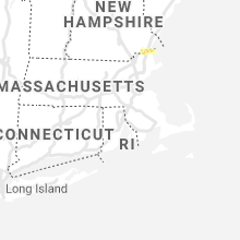
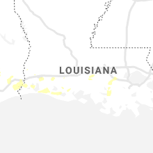
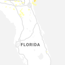
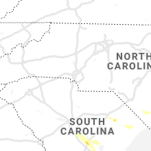
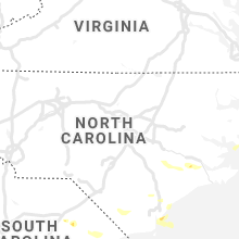
Hail Map for Tuesday, June 15, 2021

Number of Impacted Households on 6/15/2021
0
Impacted by 1" or Larger Hail
0
Impacted by 1.75" or Larger Hail
0
Impacted by 2.5" or Larger Hail
Square Miles of Populated Area Impacted on 6/15/2021
0
Impacted by 1" or Larger Hail
0
Impacted by 1.75" or Larger Hail
0
Impacted by 2.5" or Larger Hail


Cities Most Affected by Hail Storms of 6/15/2021
| Hail Size | Demographics of Zip Codes Affected | ||||||
|---|---|---|---|---|---|---|---|
| City | Count | Average | Largest | Pop Density | House Value | Income | Age |
| Shelton, NE | 2 | 1.88 | 2.00 | 10 | $64k | $37.8k | 39.0 |
| Fountain, FL | 1 | 1.75 | 1.75 | 60 | $43k | $25.5k | 40.6 |
| Santee, SC | 1 | 1.75 | 1.75 | 89 | $100k | $27.4k | 43.9 |
| Ossipee, NH | 1 | 1.75 | 1.75 | 29 | $103k | $36.3k | 47.6 |
Hail and Wind Damage Spotted on 6/15/2021
Filter by Report Type:Hail ReportsWind Reports
States Impacted
Idaho, Washington, North Carolina, Florida, New Hampshire, South Carolina, Maine, Massachusetts, New Mexico, Texas, Georgia, Nebraska, MontanaIdaho
| Local Time | Report Details |
|---|---|
| 5:15 AM PDT | Quarter sized hail reported near Moscow, ID, 67.5 miles SSE of Spokane, WA |
Washington
| Local Time | Report Details |
|---|---|
| 7:10 AM PDT | Half Dollar sized hail reported near Endicott, WA, 48.6 miles SSW of Spokane, WA |
| 8:28 AM PDT | Quarter sized hail reported near Pomeroy, WA, 45.4 miles NE of Walla Walla, WA |
| 8:39 AM PDT | Quarter sized hail reported near Pomeroy, WA, 39.5 miles NE of Walla Walla, WA |
| 1:30 PM PDT | Walla walla county sheriff confirmed several trees as well as power lines downe in walla walla county WA, 2.8 miles SW of Walla Walla, WA |
North Carolina
| Local Time | Report Details |
|---|---|
| 2:32 PM EDT | Quarter sized hail reported near Wilmington, NC, 7 miles SSE of Wilmington, NC |
| 2:38 PM EDT | Trees down on highways 11 s and 258 in lenoir county NC, 57.4 miles NNE of Wilmington, NC |
| 3:04 PM EDT | Jones county emergency manager reported numerous trees down with roof damage to outbuildings on hwy 58 s just before pollocksvill in jones county NC, 66 miles NE of Wilmington, NC |
| 3:05 PM EDT | Quarter sized hail reported near Pollocksville, NC, 66 miles NE of Wilmington, NC, jones county emergency manager observed dime to quarter sized hail on hwy 58 s just before pollocksville. time based on radar. |
| 3:05 PM EDT | Several trees down in pollocksvill in jones county NC, 67.2 miles NE of Wilmington, NC |
| 3:06 PM EDT | Jones county emergency management reported trees down on lees chapel r in jones county NC, 64.5 miles NE of Wilmington, NC |
| 4:26 PM EDT | Wind damage to exterior wooden staircase leading up to a house... swingset... and trampoline... located along bobbies way off of nc-130 in whiteville. time of event is in columbus county NC, 40.3 miles W of Wilmington, NC |
Florida
| Local Time | Report Details |
|---|---|
| 1:56 PM CDT | Spotter measured wind gusts of 60 mph near crystal lak in bay county FL, 40.1 miles E of Miramar Beach, FL |
| 3:00 PM EDT | Lauderhill fire department reported a palm tree that was toppled onto a multi-story apartment building during a strong thunderstorm. video shows that the ground was sat in broward county FL, 29 miles N of Miami, FL |
| 3:10 PM EDT | 911 call center reported a tree down near the intersection of 164th rd and 161st rd. time estimate based on rada in suwannee county FL, 74.5 miles ESE of Tallahassee, FL |
| 3:15 PM EDT | 911 call center reported a tree down near the intersection of co rd 137 & hogan rd. time estimate based on rada in suwannee county FL, 69.9 miles W of Jacksonville, FL |
| 3:15 PM EDT | 911 call center reported a tree down near the intersection of 180th st and 89th rd. time estimate based on rada in suwannee county FL, 77.6 miles W of Jacksonville, FL |
| 2:15 PM CDT | Quarter sized hail reported near Wewahitchka, FL, 61.5 miles W of Tallahassee, FL, social media report of quarter sized hail in southwestern calhoun county. |
| 3:20 PM EDT | 911 call center reported a tree down near the intersection of sr 247 & cr 137. time estimate based on rada in suwannee county FL, 71.9 miles WSW of Jacksonville, FL |
| 3:25 PM EDT | 911 call center reported a tree down near the intersection of 256th st & 41st rd. time estimate based on rada in suwannee county FL, 74.1 miles WSW of Jacksonville, FL |
| 2:30 PM CDT | Report of estimated 70 mph wind gust near cherokee landin in bay county FL, 45.8 miles E of Miramar Beach, FL |
| 2:30 PM CDT | Quarter sized hail reported near Youngstown, FL, 56.8 miles E of Miramar Beach, FL, social media report of dime to quarter size hail in northern bay county east of highway 231. |
| 2:44 PM CDT | Spotter reports measured wind gust of 59 mph near youngstow in bay county FL, 57.4 miles E of Miramar Beach, FL |
| 2:59 PM CDT | Golf Ball sized hail reported near Fountain, FL, 58.1 miles E of Miramar Beach, FL, received a report of golf ball size hail along the bay/calhoun county line along highway 20. |
| 4:10 PM EDT | Quarter sized hail reported near Sanderson, FL, 41.1 miles W of Jacksonville, FL, **correction** storm spotter called in a report of quarter size hail falling at his residence near the intersection of cr 235 and sr100. |
| 4:15 PM EDT | Corrects time of previous tstm wnd dmg report from newport. 911 call center reported multiple trees dow in wakulla county FL, 17.6 miles SSE of Tallahassee, FL |
| 4:15 PM EDT | Fallen trees or limbs resulted in a power outage near woodville highway and shadeville road as reported by duke energ in wakulla county FL, 14.8 miles SSE of Tallahassee, FL |
| 4:20 PM EDT | 911 call center reported a tree down near the intersection of nw cr 229 and cr 229a. time estimate based on rada in bradford county FL, 38.4 miles SW of Jacksonville, FL |
| 4:25 PM EDT | 911 call center reported a tree down near the intersection of nw 180th st & northwest 75th avenue. time estimate based on rada in bradford county FL, 39.2 miles SW of Jacksonville, FL |
| 4:26 PM EDT | Received a report on social media of a tree knocked dow in wakulla county FL, 29 miles SSW of Tallahassee, FL |
| 4:27 PM EDT | Fallen trees or limbs resulted in a power outage in the saint marks areas as reported on the duke energy outage ma in wakulla county FL, 19.7 miles SSE of Tallahassee, FL |
| 3:30 PM CDT | Report of trees down in northern gulf count in gulf county FL, 67.5 miles WSW of Tallahassee, FL |
| 4:55 PM EDT | 911 call center reported a tree was knocked dow in madison county FL, 47.8 miles ENE of Tallahassee, FL |
| 5:02 PM EDT | 911 call center reported multiple trees dow in wakulla county FL, 17.6 miles SSE of Tallahassee, FL |
| 5:05 PM EDT | Trained spotter reported a tree was knocked dow in madison county FL, 50.5 miles ENE of Tallahassee, FL |
| 5:10 PM EDT | 911 call center reported a tree was knocked dow in madison county FL, 52.8 miles E of Tallahassee, FL |
| 5:18 PM EDT | 911 call center reported a tree was knocked dow in madison county FL, 53.1 miles E of Tallahassee, FL |
| 5:20 PM EDT | 911 call center reported a tree was knocked dow in madison county FL, 53.4 miles E of Tallahassee, FL |
| 5:30 PM EDT | 911 call center reported a tree and power line down near the 5900 block of east university avenue. time estimate based on rada in alachua county FL, 59.3 miles SW of Jacksonville, FL |
| 5:30 PM EDT | 911 call center reported a tree down near the intersection of northwest 15th place & fort clarke boulevard. time estimate based on rada in alachua county FL, 65 miles SW of Jacksonville, FL |
| 5:35 PM EDT | 911 call center reported a tree down at 2643 nw 13th st (us441). time estimate based on rada in alachua county FL, 60.8 miles SW of Jacksonville, FL |
| 5:35 PM EDT | 911 call center reported a tree was knocked dow in madison county FL, 59.1 miles E of Tallahassee, FL |
| 5:40 PM EDT | Tree down on ne lantana stree in madison county FL, 60.9 miles E of Tallahassee, FL |
| 6:01 PM EDT | Mesonet station xjak jacksonvill in duval county FL, 11.3 miles ENE of Jacksonville, FL |
| 6:05 PM EDT | 911 call center reported a tree down near the intersection of east buffalo bluff rd & cove drive. time estimate based on rada in putnam county FL, 51.8 miles S of Jacksonville, FL |
| 6:06 PM EDT | Mesonet station xhup huguenot par in amz452 county FL, 15.9 miles ENE of Jacksonville, FL |
| 8:45 PM EDT | Resident called in a report of wind damage due to thunderstorm wind at sw 144th lane near sr121. power was knocked out... several large trees pushed down and a chicken in alachua county FL, 71.5 miles SW of Jacksonville, FL |
New Hampshire
| Local Time | Report Details |
|---|---|
| 3:30 PM EDT | Trees down around lake waukewan west of meredit in belknap county NH, 62.8 miles W of Portland, ME |
| 4:00 PM EDT | Ping Pong Ball sized hail reported near Mirror Lake, NH, 50.3 miles W of Portland, ME, hail between 1.25 and 1.5 in fell for about 5 minutes. some small branches also snapped. time estimated by radar. |
| 4:14 PM EDT | Spotter reports several branches up to 2in diameter and small trees throughout town on nh-140. time estimated by rada in belknap county NH, 60.7 miles WSW of Portland, ME |
| 4:15 PM EDT | Golf Ball sized hail reported near Ossipee, NH, 43.3 miles W of Portland, ME, golf ball sized hail fell and covered grassy areas. a few small branches snapped as well. |
| 4:40 PM EDT | Tree down on albuquerque rd in litchfield... partially blocking southbound lan in hillsborough county NH, 70.9 miles N of Providence, RI |
| 4:44 PM EDT | Tree down on daniel webster highway at bedford r in hillsborough county NH, 73.7 miles N of Providence, RI |
| 5:10 PM EDT | Several branches down across highway 121. small hail also fell for about 2 minute in rockingham county NH, 71.5 miles SW of Portland, ME |
| 5:40 PM EDT | Large tree fell down blocking walton rd near centennial ave in seabroo in rockingham county NH, 61.8 miles SSW of Portland, ME |
South Carolina
| Local Time | Report Details |
|---|---|
| 3:50 PM EDT | A tree fell across pee dee highway... near the antioch road intersection. time of event is radar estimate in horry county SC, 64.3 miles NE of Charleston, SC |
| 4:20 PM EDT | Large tree limbs snapped by strong winds in the avalon family community neighborhood in carolina forest. time of event is radar estimate in horry county SC, 64.8 miles WSW of Wilmington, NC |
| 4:50 PM EDT | Half Dollar sized hail reported near Ridgeville, SC, 12.3 miles WSW of Charleston, SC, the public measured hail the size of a half dollar coin. |
| 6:00 PM EDT | Numerous trees down along burke r in calhoun county SC, 56.3 miles WNW of Charleston, SC |
| 6:05 PM EDT | Sc highway patrol reports trees down near the intersection of belleville rd and moorer rd. time estimated from rada in calhoun county SC, 51.5 miles WNW of Charleston, SC |
| 6:12 PM EDT | Calhoun county dispatch reports widespread trees down across the county. time estimated from rada in calhoun county SC, 46.6 miles WNW of Charleston, SC |
| 6:33 PM EDT | Sc highway patrol reports trees down near the intersection of us 301 and felderville rd. time estimated from rada in orangeburg county SC, 36.5 miles WNW of Charleston, SC |
| 6:38 PM EDT | Orangeburg county em reports tree damage along vance road. reports of tree tops snapped off and multiple trees uproote in orangeburg county SC, 32.1 miles WNW of Charleston, SC |
| 6:41 PM EDT | Golf Ball sized hail reported near Santee, SC, 34.2 miles WNW of Charleston, SC, the orangeburg county emergency manager reports golf ball sized hail near santee. the em also reports significant damage to lake marion high school including damage to |
| 6:45 PM EDT | Sc highway patrol reports trees down near the intersection of us 176 and us 15. time estimated from rada in orangeburg county SC, 29.6 miles WNW of Charleston, SC |
| 6:51 PM EDT | Orangeburg county 911 reports widespread trees down across the eastern portion of the county. operator said they had gotten reports from elloree to eutawville. time est in orangeburg county SC, 23.4 miles WNW of Charleston, SC |
| 7:31 PM EDT | The public reported a tree down on church roa in jasper county SC, 15.1 miles N of Savannah, GA |
| 7:39 PM EDT | The public reported a large branch split off a tree near the intersection of highway 52 and 17 in berkeley county SC, 1.3 miles E of Charleston, SC |
| 7:40 PM EDT | Measured by nws wind equipment along the south side of lake moultri in berkeley county SC, 4 miles NNW of Charleston, SC |
| 7:45 PM EDT | The public reported a pecan tree uprooted and a small horse shelter blown ove in hampton county SC, 58.5 miles N of Savannah, GA |
| 7:47 PM EDT | Law enforcement reported trees and power lines down along may river road between gibbet road and simmonsville road. time based on rada in beaufort county SC, 13.7 miles NE of Savannah, GA |
| 7:50 PM EDT | Quarter sized hail reported near Charleston, SC, 25.7 miles S of Charleston, SC, the public reported quarter size hail in grand oak plantation. |
| 7:51 PM EDT | The public reported 2 trees approximately 1 foot in diameter snapped 10 feet off the ground near the intersection of bimimi drive and bluewater wa in charleston county SC, 27.1 miles S of Charleston, SC |
| 8:05 PM EDT | Quarter sized hail reported near Charleston, SC, 28.8 miles S of Charleston, SC, the public reported quarter size hail at south windermere |
| 8:05 PM EDT | A tree was reported down near river reach wa in charleston county SC, 25.3 miles S of Charleston, SC |
| 8:14 PM EDT | Quarter sized hail reported near Charleston, SC, 33.3 miles S of Charleston, SC, the public reported quarter size hail near lighthouse point. |
| 8:23 PM EDT | Quarter sized hail reported near Mount Pleasant, SC, 27.6 miles SSE of Charleston, SC, the media reported quarter size hail near the intersection of rifle range road and the iop connector. |
| 10:37 PM EDT | Quarter sized hail reported near Okatie, SC, 16.4 miles NNE of Savannah, GA, a trained spotter reported quarter size hail near sunbeam drive. |
Maine
| Local Time | Report Details |
|---|---|
| 5:00 PM EDT | Trees dow in oxford county ME, 46.1 miles NNW of Portland, ME |
Massachusetts
| Local Time | Report Details |
|---|---|
| 5:45 PM EDT | Half Dollar sized hail reported near Newburyport, MA, 66.8 miles SSW of Portland, ME, cocorahs observer |
New Mexico
| Local Time | Report Details |
|---|---|
| 4:52 PM MDT | 1 inch tree limbs broken and shingles stripped from roof in santa fe county NM, 50.9 miles NE of Albuquerque, NM |
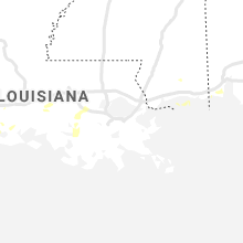
Texas
| Local Time | Report Details |
|---|---|
| 5:58 PM CDT | Quarter sized hail reported near Houston, TX, 6 miles NW of Houston, TX, report from mping: quarter (1.00 in.). |
| 6:00 PM CDT | Quarter sized hail reported near Houston, TX, 5.5 miles NW of Houston, TX |
| 6:00 PM CDT | Quarter sized hail reported near Houston, TX, 2.8 miles NNW of Houston, TX, quarter size hail. |
| 6:01 PM CDT | Quarter sized hail reported near Houston, TX, 3.5 miles N of Houston, TX, report from mping: quarter (1.00 in.). |
| 6:07 PM CDT | Quarter sized hail reported near Houston, TX, 4.8 miles NNW of Houston, TX, pea to quarter sized hail reported in the garden oaks/oak forest neighborhood. |
| 6:26 PM CDT | Quarter sized hail reported near Houston, TX, 6.8 miles NW of Houston, TX, report from mping: quarter (1.00 in.). |
| 6:40 PM CDT | Quarter sized hail reported near Pasadena, TX, 13.4 miles E of Houston, TX |
| 6:50 PM CDT | Mesonet station xcrb crab lak in galveston county TX, 49.4 miles ESE of Houston, TX |
| 7:02 PM CDT | Weatherflow crab lake sit in gmz335 county TX, 49.6 miles ESE of Houston, TX |
| 7:09 PM CDT | Galveston fishing pie in galveston county TX, 47.1 miles SE of Houston, TX |
| 7:12 PM CDT | Buoy station gnjt2 galveston bay entrance... north jetty... in gmz355 county TX, 47.9 miles SE of Houston, TX |
| 7:35 PM CDT | Public reported a measured wind speed of 62 mph... with a power outage shortly after. also noted some downed tree in bexar county TX, 9.7 miles WNW of San Antonio, TX |
| 7:52 PM CDT | Downed power lines due to strong wind in fort bend county TX, 33.7 miles SW of Houston, TX |
| 7:55 PM CDT | Quarter sized hail reported near Bandera, TX, 39.5 miles WNW of San Antonio, TX, mostly dime to nickel sized hail with a few hailstones up to quarter sized. |
Georgia
| Local Time | Report Details |
|---|---|
| 8:10 PM EDT | The crisp county emergency manager reported power lines down on rockhouse road near i-7 in crisp county GA, 59.9 miles WNW of Douglas, GA |
| 8:15 PM EDT | The crisp county emergency manager reported trees and power lines down on rains station roa in crisp county GA, 65.1 miles WNW of Douglas, GA |
Nebraska
| Local Time | Report Details |
|---|---|
| 7:25 PM CDT | Hen Egg sized hail reported near Shelton, NE, 22.7 miles WSW of Grand Island, NE, fb photo. |
| 7:30 PM CDT | Golf Ball sized hail reported near Shelton, NE, 22.7 miles WSW of Grand Island, NE |
Montana
| Local Time | Report Details |
|---|---|
| 7:30 PM MDT | Report via media on twitter with photo of a large tree branch that smashed a car windshiel in lake county MT, 45.6 miles N of Missoula, MT |
Connect with Interactive Hail Maps