

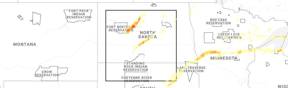
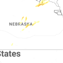
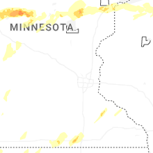
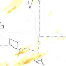
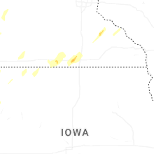
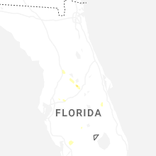
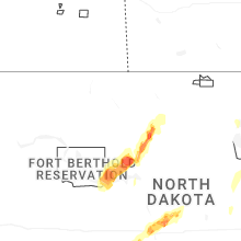
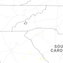
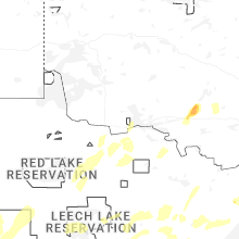
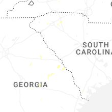
Hail Map for Monday, June 29, 2026
Number of Impacted Households on 6/29/2026
0
Impacted by 1" or Larger Hail
0
Impacted by 1.75" or Larger Hail
0
Impacted by 2.5" or Larger Hail
Square Miles of Populated Area Impacted on 6/29/2026
0
Impacted by 1" or Larger Hail
0
Impacted by 1.75" or Larger Hail
0
Impacted by 2.5" or Larger Hail
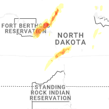
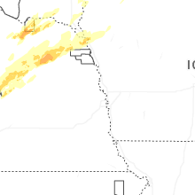
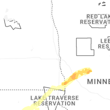

Cities Most Affected by Hail Storms of 6/29/2026
| Hail Size | Demographics of Zip Codes Affected | ||||||
|---|---|---|---|---|---|---|---|
| City | Count | Average | Largest | Pop Density | House Value | Income | Age |
| Moorhead, MN | 3 | 2.17 | 3.00 | 243 | $89k | $36.6k | 29.1 |
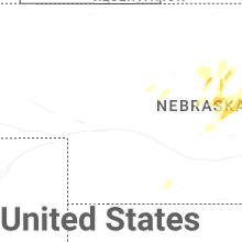
| Scotia, NE | 2 | 2.88 | 3.00 | 2 | $24k | $25.9k | 43.3 |
| Barnum, MN | 3 | 1.75 | 1.75 | 21 | $83k | $42.2k | 40.5 |
| Bismarck, ND | 2 | 1.88 | 2.00 | 210 | $0k | $0.0k | 37.5 |
| Max, ND | 1 | 2.25 | 2.25 | 2 | $32k | $29.8k | 38.1 |
| Hendersonville, NC | 1 | 2.00 | 2.00 | 309 | $111k | $32.8k | 41.3 |
| Mandan, ND | 1 | 2.00 | 2.00 | 38 | $83k | $39.5k | 37.6 |
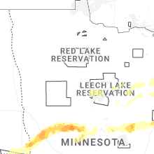
| Mcgregor, MN | 1 | 2.00 | 2.00 | 8 | $98k | $28.5k | 52.0 |
| Hoskins, NE | 1 | 2.00 | 2.00 | 8 | $72k | $34.3k | 39.2 |
| Center, NE | 1 | 1.75 | 1.75 | 2 | $25k | $27.0k | 49.8 |
| Elmira, MI | 1 | 1.75 | 1.75 | 22 | $87k | $37.2k | 42.0 |
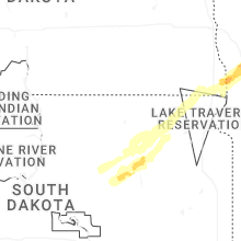
| Eden, SD | 1 | 1.75 | 1.75 | 3 | $33k | $23.8k | 47.6 |
Hail and Wind Damage Spotted on 6/29/2026
Filter by Report Type:Hail ReportsWind Reports
States Impacted
South Dakota, North Dakota, Minnesota, Michigan, South Carolina, Wisconsin, Georgia, Texas, North Carolina, Nebraska, Tennessee, Iowa, OklahomaSouth Dakota
| Local Time | Report Details |
|---|---|
| 7:05 AM CDT | Mesonet station rhms2 rockham 6sse (sd mesonet in hand county SD, 46.7 miles SSW of Aberdeen, SD |
| 7:21 AM CDT | Ambient weather statio in spink county SD, 36.9 miles S of Aberdeen, SD |
| 7:21 AM CDT | Ambient weather statio in spink county SD, 34.9 miles S of Aberdeen, SD |
| 7:45 AM CDT | Ambient weather statio in brown county SD, 14.4 miles SSE of Aberdeen, SD |
| 7:59 AM CDT | Report of tree damage in the amsden dam lake area. time estimate in day county SD, 26.7 miles ESE of Aberdeen, SD |
| 8:03 AM CDT | Tree damage reported in andove in day county SD, 28.8 miles E of Aberdeen, SD |
| 8:04 AM CDT | Quarter sized hail reported near Groton, SD, 18.8 miles E of Aberdeen, SD |
| 8:04 AM CDT | Damage to several metal buildings... bleachers blown over... and a broken window. metal buildings had doors and walls pushed in... which led to portions of the metal ro in day county SD, 29.2 miles E of Aberdeen, SD |
| 8:07 AM CDT | Mesonet station 45 andover (sddot in day county SD, 28.8 miles E of Aberdeen, SD |
| 8:22 AM CDT | Report of powerlines down. time estimate in day county SD, 36.7 miles ESE of Aberdeen, SD |
| 8:33 AM CDT | Report of 1-2 inch diameter tree branches dow in day county SD, 47.8 miles E of Aberdeen, SD |
| 8:40 AM CDT | Golf Ball sized hail reported near Eden, SD, 51.9 miles ENE of Aberdeen, SD, relayed a report of golf ball sized hail near eden. time estimated via radar. |
| 9:10 AM CDT | Mesonet station shms2 sica hollow (sd mesonet in marshall county SD, 63 miles ENE of Aberdeen, SD |
| 7:52 PM CDT | Quarter sized hail reported near Yankton, SD, 58 miles SW of Sioux Falls, SD |
| 8:04 PM CDT | Quarter sized hail reported near Yankton, SD, 52.5 miles SSW of Sioux Falls, SD |
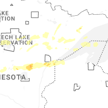
North Dakota
| Local Time | Report Details |
|---|---|
| 9:10 AM CDT | Tree downed...time estimated from rada in richland county ND, 58.4 miles SSW of Fargo, ND |
| 3:29 PM CDT | 63 mph wind gust at 10m measured from mandan 4s ndaw in morton county ND, 6.7 miles WSW of Bismarck, ND |
| 3:32 PM CDT | Hen Egg sized hail reported near Mandan, ND, 5.5 miles WNW of Bismarck, ND, trained weather spotter reports hail up to 2 inches in mandan. hail ranged from 1.5 to 2.0 inches in size... and lasted for around 5 minutes. also report numerous 1 inc |
| 3:38 PM CDT | Golf Ball sized hail reported near Bismarck, ND, 5.4 miles NNW of Bismarck, ND, off duty nws employee reported golf ball size hail and 60 mph wind gusts. one window on house was broken. |
| 3:38 PM CDT | Quarter sized hail reported near Granville, ND, 21.2 miles E of Minot, ND, also reported 60 mph wind gusts. |
| 3:40 PM CDT | Half Dollar sized hail reported near Granville, ND, 21.2 miles E of Minot, ND, [delayed report] broadcast media relayed a photo of a hailstone larger than a quarter placed as a point of comparison... taken 5 miles south of granville. time estimate |
| 3:41 PM CDT | Quarter sized hail reported near Bismarck, ND, 3.8 miles N of Bismarck, ND |
| 3:45 PM CDT | Hen Egg sized hail reported near Bismarck, ND, 6.6 miles N of Bismarck, ND, time estimated from radar. |
| 4:10 PM CDT | Asos station kn60 garriso in mclean county ND, 41 miles S of Minot, ND |
| 4:10 PM CDT | Ping Pong Ball sized hail reported near Baldwin, ND, 18.9 miles NE of Bismarck, ND, photo relayed through broadcast media of multiple large hailstones. |
| 4:20 PM CDT | Half Dollar sized hail reported near Max, ND, 33.7 miles S of Minot, ND, us air force observer reported half dollar size hail near max. hail fell for around 12 minutes. also reports torrential rainfall. |
| 4:30 PM CDT | Hen Egg sized hail reported near Max, ND, 28.7 miles S of Minot, ND, relayed through broadcast media. |
| 4:34 PM CDT | Measured wind gust at us air force weather statio in mclean county ND, 30.1 miles S of Minot, ND |
| 4:34 PM CDT | 70 mph winds at 10m measured at max 3n ndawn; 67 mph at 3 in ward county ND, 25.3 miles S of Minot, ND |
| 4:52 PM CDT | 59 mph winds at 10m measured at sawyer 7s ndaw in ward county ND, 20.1 miles SSE of Minot, ND |
| 4:55 PM CDT | Ping Pong Ball sized hail reported near Wing, ND, 38.2 miles NE of Bismarck, ND, relayed through broadcast media. |
| 4:04 PM MDT | Quarter sized hail reported near Hettinger, ND, 104.9 miles WSW of Bismarck, ND, at 4:04 mdt... emergency management reported quarter sized hail in the city of hettinger. still hailing at the time of report. also reports rain... but no wind. |
| 5:09 PM CDT | Measured wind gust at personal weather statio in mchenry county ND, 20.5 miles SE of Minot, ND |
| 7:00 PM MDT | Quarter sized hail reported near South Heart, ND, 93.7 miles SSE of Williston, ND, public reports hail in south heart. estimates the largest hailstone is around 1.0 inch in size. time estimated from radar. |
| 8:11 PM CDT | Half Dollar sized hail reported near Fargo, ND, 6 miles S of Fargo, ND, relayed via mping. |
| 7:25 PM MDT | Quarter sized hail reported near New England, ND, 101.1 miles W of Bismarck, ND, co op observer reports 1 inch hail in new england. mixed with lots of small... pea sized hail. |
| 9:05 PM CDT | Quarter sized hail reported near Pettibone, ND, 63.4 miles ENE of Bismarck, ND, [delayed report] broadcast media relayed photo of hail in pettibone approximately the size of quarters. |
| 10:15 PM CDT | Rugby awos statio in pierce county ND, 56.8 miles WNW of Devils Lake, ND |
| 11:15 PM CDT | Awos station k06d rolla nd awo in rolette county ND, 63.6 miles NNW of Devils Lake, ND |
| 11:30 PM CDT | Nddot 040 in clyd in cavalier county ND, 46.9 miles N of Devils Lake, ND |
Minnesota
| Local Time | Report Details |
|---|---|
| 9:40 AM CDT | Mesonet station mn054 tenney mn do in wilkin county MN, 59.4 miles SSE of Fargo, ND |
| 10:03 AM CDT | Storm damage reported in wilkin county MN, 46 miles SSE of Fargo, ND |
| 10:38 AM CDT | Half Dollar sized hail reported near Richville, MN, 57.4 miles ESE of Fargo, ND, hail at dead lake...time estimated from radar. |
| 11:15 AM CDT | Accompanied by 1.25 hai in wadena county MN, 72.3 miles S of Bemidji, MN |
| 11:16 AM CDT | Ndaw in clay county MN, 9.3 miles SE of Fargo, ND |
| 11:19 AM CDT | Ndaw in clay county MN, 10.6 miles E of Fargo, ND |
| 11:20 AM CDT | Delayed report: multiple trees down with tree branch diameter between 12 inches to 15 inche in becker county MN, 27.8 miles SW of Bemidji, MN |
| 11:20 AM CDT | Half Dollar sized hail reported near Wadena, MN, 72.9 miles S of Bemidji, MN |
| 11:37 AM CDT | Quarter sized hail reported near Sebeka, MN, 58.4 miles S of Bemidji, MN, report from mping: quarter (1.00 in.). |
| 12:00 PM CDT | Trees down near hwy 64 and 96th street. time estimated from rada in cass county MN, 70.8 miles S of Bemidji, MN |
| 12:00 PM CDT | Tree broken off. deck furniture and grill blown off deck. report through cocorah in cass county MN, 28.9 miles ESE of Bemidji, MN |
| 12:25 PM CDT | Photos were received of downed trees in bena. some trees were snapped and another was tipped pulling up the roots. time estimated from rada in cass county MN, 32.7 miles ESE of Bemidji, MN |
| 12:34 PM CDT | A 100 foot tall tree down that had no previous damage. multiple other smaller trees down as well. branches were found speared into the ground after the storm. time esti in crow wing county MN, 74.2 miles SSE of Bemidji, MN |
| 12:40 PM CDT | Two large trees down on hom in itasca county MN, 42.7 miles E of Bemidji, MN |
| 12:46 PM CDT | Personal weather station on deer lak in itasca county MN, 58 miles E of Bemidji, MN |
| 12:51 PM CDT | Several trees were reported down in bovey. time estimated by rada in itasca county MN, 69.5 miles E of Bemidji, MN |
| 12:55 PM CDT | A few large white pine trees blown down on propert in itasca county MN, 65.3 miles E of Bemidji, MN |
| 1:00 PM CDT | Storm damage reported in cass county MN, 33.4 miles ESE of Bemidji, MN |
| 1:01 PM CDT | Time stamped video was received showing a tree being knocked over in the storm. a 2 inch diameter flagpole was broken and a weather station was flipped over around the in itasca county MN, 59 miles WNW of Duluth, MN |
| 1:05 PM CDT | A few moderate size tree branches were down but no full trees. wind lasted about five minute in itasca county MN, 72.7 miles NW of Duluth, MN |
| 1:05 PM CDT | Ping Pong Ball sized hail reported near Bovey, MN, 69.3 miles E of Bemidji, MN |
| 1:15 PM CDT | A photo was received of a tree down on a home. time estimated from rada in st. louis county MN, 60.9 miles NW of Duluth, MN |
| 1:20 PM CDT | Mndot rwis station mn092 us 169 mitchell bridge mp 34 in st. louis county MN, 59 miles NW of Duluth, MN |
| 1:35 PM CDT | Ping Pong Ball sized hail reported near Aitkin, MN, 76.2 miles WSW of Duluth, MN, mostly quarter size but a few up to 1.5 inches. |
| 1:50 PM CDT | Report of a tree down on top of a house and power lines in gilber in st. louis county MN, 51.5 miles NNW of Duluth, MN |
| 1:55 PM CDT | Two large trees snapped in half. wind was very localize in st. louis county MN, 51.7 miles N of Duluth, MN |
| 1:56 PM CDT | Multiple reports of power lines down in the virginia are in st. louis county MN, 54.7 miles NNW of Duluth, MN |
| 1:58 PM CDT | Report of tree down on power lines with the tree hanging over the roadwa in st. louis county MN, 66.7 miles NNW of Duluth, MN |
| 2:00 PM CDT | Quarter sized hail reported near Mcgregor, MN, 53 miles WSW of Duluth, MN |
| 2:00 PM CDT | Hen Egg sized hail reported near Mcgregor, MN, 53.7 miles WSW of Duluth, MN, hail was mostly to the size of grapes but a few were to the size of golf balls to hen egg. |
| 2:08 PM CDT | Two reports of wires down in the area from trees falling on the in st. louis county MN, 56.2 miles NW of Duluth, MN |
| 2:10 PM CDT | Trees down on roadway. mostly poplar and pine trees snapped at top. power is of in st. louis county MN, 52.9 miles NNW of Duluth, MN |
| 2:34 PM CDT | Golf Ball sized hail reported near Barnum, MN, 34.4 miles SW of Duluth, MN |
| 2:37 PM CDT | Ping Pong Ball sized hail reported near Barnum, MN, 34.4 miles SW of Duluth, MN |
| 2:40 PM CDT | Golf Ball sized hail reported near Barnum, MN, 34.4 miles SW of Duluth, MN, photo was received of a hail stone that was an agglomeration of multiple stones next to a baseball. size was estimated. |
| 2:41 PM CDT | Golf Ball sized hail reported near Barnum, MN, 29.4 miles WSW of Duluth, MN, quarter to golf ball sized hail near mahtowa. time estimated by radar. |
| 3:00 PM CDT | Quarter sized hail reported near Wrenshall, MN, 17.7 miles SW of Duluth, MN, photo sent in via social media showing the largest hailstone next to a quarter. also two other smaller hailstones in the picture. |
| 8:15 PM CDT | Tea Cup sized hail reported near Moorhead, MN, 3.2 miles S of Fargo, ND, time estimated via radar. |
| 8:17 PM CDT | Golf Ball sized hail reported near Moorhead, MN, 1.6 miles ESE of Fargo, ND |
| 8:25 PM CDT | Golf Ball sized hail reported near Moorhead, MN, 2 miles ESE of Fargo, ND |
| 9:08 PM CDT | Trees down (estimated 20 feet in height in clay county MN, 28.4 miles ENE of Fargo, ND |
| 9:45 PM CDT | Quarter sized hail reported near Glenwood, MN, 50.8 miles NNE of Montevideo, MN |
| 9:55 PM CDT | Reports of tree damage in alexandri in douglas county MN, 66.8 miles NNE of Montevideo, MN |
| 10:00 PM CDT | Ping Pong Ball sized hail reported near West Union, MN, 66.3 miles NNE of Montevideo, MN |
| 10:05 PM CDT | Quarter sized hail reported near Bemidji, MN, 4.9 miles WNW of Bemidji, MN |
| 10:40 PM CDT | Mndot station mn124 0.5n motle in cass county MN, 78.5 miles S of Bemidji, MN |
| 11:10 PM CDT | Asos station kbrd brainerd airpor in crow wing county MN, 82.2 miles SSE of Bemidji, MN |
| 11:59 PM CDT | A photo was received of a 6-8 inch white pine limb skewered into the ground. time estimated by rada in aitkin county MN, 56.9 miles WNW of Duluth, MN |
| 12:00 AM CDT | A photo was received of a large birch tree across highway 200 blocking the road. multiple trees were down in this are in aitkin county MN, 54.1 miles WNW of Duluth, MN |
| 2:48 AM CDT | Davis personal weather statio in jackson county MN, 69.4 miles N of Storm Lake, IA |
| 2:50 AM CDT | Mesonet station mn008 i-90 - lakefield - mp 6 in jackson county MN, 68.6 miles N of Storm Lake, IA |
| 2:55 AM CDT | Awos station kmjq jackson airpor in jackson county MN, 68.8 miles N of Storm Lake, IA |
| 2:59 AM CDT | Davis personal weather statio in jackson county MN, 78 miles N of Storm Lake, IA |
| 3:04 AM CDT | Ambient personal weather statio in cottonwood county MN, 82 miles SSE of Montevideo, MN |
| 3:06 AM CDT | Lots of tree damage and possibly some structural damage to house. will assess further in dayligh in jackson county MN, 80.1 miles N of Storm Lake, IA |
| 3:08 AM CDT | Ambient personal weather statio in cottonwood county MN, 83.5 miles SSE of Montevideo, MN |
| 3:09 AM CDT | Davis personal weather statio in cottonwood county MN, 79 miles SSE of Montevideo, MN |
| 3:10 AM CDT | Mndot road observation site recorded a wind gust of 67 mp in martin county MN, 77.1 miles NNE of Storm Lake, IA |
| 3:10 AM CDT | Ndawn statio in jackson county MN, 82.8 miles N of Storm Lake, IA |
| 3:10 AM CDT | Mesonet station mn150 t.h.60 - mountain lake - mp 4 in cottonwood county MN, 79.6 miles SSE of Montevideo, MN |
| 3:15 AM CDT | Storm damage reported in watonwan county MN, 82.1 miles SE of Montevideo, MN |
| 3:22 AM CDT | Storm damage reported in watonwan county MN, 83 miles NW of Mason City, IA |
| 3:35 AM CDT | St. james municipal airport asos recorded a 60 mph wind gus in watonwan county MN, 87.7 miles SE of Montevideo, MN |
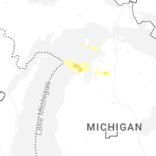
Michigan
| Local Time | Report Details |
|---|---|
| 11:20 AM EDT | Ping Pong Ball sized hail reported near Elmira, MI, 35.2 miles ENE of Traverse City, MI |
| 11:40 AM EDT | Golf Ball sized hail reported near Elmira, MI, 35.2 miles ENE of Traverse City, MI |
| 12:45 PM EDT | Numerous trees downed on state rd south of robinson rd. time estimated by rada in emmet county MI, 62.1 miles NNE of Traverse City, MI |
| 4:10 PM CDT | Mulitple trees and lines down on black river rd. time estimated from rada in gogebic county MI, 70.9 miles NNW of Rhinelander, WI |
| 5:14 PM EDT | Tree down on powerlines. time estimated from rada in ontonagon county MI, 82.7 miles N of Rhinelander, WI |
| 5:25 PM EDT | Video on social media shows significant tree damage including trees uprooted and fallen. power is out... cars... campers... tents... canopies... and awnings are damaged in lsz242 county MI, 86.6 miles N of Rhinelander, WI |
| 5:26 PM EDT | Numerous trees and branches dow in ontonagon county MI, 85.2 miles N of Rhinelander, WI |
| 6:04 PM EDT | Multiple reports of trees down. time estimated from rada in houghton county MI, 62.6 miles WNW of Marquette, MI |
| 6:04 PM EDT | Tree fell on a structure on halfmoon rd in chassell. trees also down elsewhere in chassell twp and bootjack. time estimated from rada in houghton county MI, 61.5 miles WNW of Marquette, MI |
| 6:04 PM EDT | Social media report of 12 inch diameter trees snapped on fishermans lane in chassell. trees down across driveways and roads... with limbs of varying sizes around the ar in houghton county MI, 57.9 miles WNW of Marquette, MI |
| 6:07 PM EDT | Trees and power lines down on the road to the beach near white city have stranded some cars for a period of time. time estimated from rada in houghton county MI, 56.8 miles WNW of Marquette, MI |
| 6:10 PM EDT | Social media post of a tree down at portage river lighthouse... causing damage to the chain fence at the shoreline. time estimated from rada in houghton county MI, 56 miles WNW of Marquette, MI |
| 6:45 PM EDT | Social media picture of a large tree limb that fell on a rv at van riper state park. time estimated from rada in marquette county MI, 27.5 miles W of Marquette, MI |
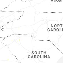
South Carolina
| Local Time | Report Details |
|---|---|
| 3:15 PM EDT | Tree down near edgefield street and north calhoun shores parkwa in abbeville county SC, 50.4 miles S of Greenville, SC |
| 3:20 PM EDT | Trees and power lines down on the west side of easle in pickens county SC, 1.1 miles W of Greenville, SC |
| 3:28 PM EDT | Tree down near wilton drive and westwood circl in pickens county SC, 3.9 miles WNW of Greenville, SC |
| 3:30 PM EDT | Tree down on roadwa in anderson county SC, 4.9 miles SE of Greenville, SC |
| 3:39 PM EDT | Tree down on roadwa in pickens county SC, 4 miles WSW of Greenville, SC |
| 4:30 PM EDT | Power outage caused by trees on powerline in anderson county SC, 6.9 miles SE of Greenville, SC |
| 4:53 PM EDT | Reported power outage due to trees and limbs on powerline in spartanburg county SC, 39.7 miles ENE of Greenville, SC |
| 7:30 PM EDT | Reported power outage due to trees and limbs on powerline in spartanburg county SC, 44.4 miles ENE of Greenville, SC |
Wisconsin
| Local Time | Report Details |
|---|---|
| 3:11 PM CDT | Several large trees down on the highway between bayfield and washburn around 12 inches in diamete in bayfield county WI, 58.8 miles E of Duluth, MN |
| 3:41 PM CDT | Trees were reported down across county highways b and p outside lake nebagemon. time estimated by rada in douglas county WI, 26 miles SE of Duluth, MN |
| 4:53 PM CDT | Photos were received showing multiple trees down in ashland following the storms. time estimated by rada in ashland county WI, 60.2 miles ESE of Duluth, MN |
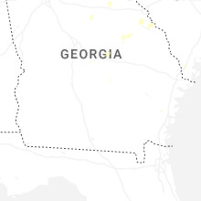
Georgia
| Local Time | Report Details |
|---|---|
| 4:15 PM EDT | The screven county 911 call center reported a tree down near the intersection of rocky ford road and deer run roa in screven county GA, 52.4 miles SSE of Augusta, GA |
| 5:38 PM EDT | Richmond county 911 call center reported wires down on state road 88 near hopson mill road. location coincides with a power outage on the georgia power website. time es in burke county GA, 20.1 miles SW of Augusta, GA |
| 5:44 PM EDT | Three large trees down on guard camp roa in stephens county GA, 51.1 miles WSW of Greenville, SC |
| 8:30 PM EDT | Several trees were downed in the vicinity of joycliff road and new clinton roa in jones county GA, 76.4 miles SE of Atlanta, GA |
Texas
| Local Time | Report Details |
|---|---|
| 4:00 PM CDT | Excel mesonet 11 miles se of canyon recorded 60 mph wind gust at 4:00 p in randall county TX, 23.5 miles S of Amarillo, TX |
| 4:09 PM CDT | Estimated 80 mph wind gusts from trained spotter 3 miles south of rick husband amarillo international airpor in randall county TX, 7.5 miles ESE of Amarillo, TX |
| 4:20 PM CDT | Report of 80.5 mph wind gust at 10 meters from the doe net tower 2 miles north of pante in carson county TX, 19.3 miles ENE of Amarillo, TX |
| 4:26 PM CDT | 62 mph wind gust measured at the wt mesonet site 6 mile ne of pantex... on the nw side of pantex lake. severe gusts persisted from 4:26 to 4:28 p in carson county TX, 22.3 miles ENE of Amarillo, TX |
| 4:30 PM CDT | Picture of a tree blown down... potentially rotted inside. estimated wind gusts around 60 mp in potter county TX, 9.4 miles E of Amarillo, TX |
| 5:30 PM CDT | Xcel mesonet site 5 miles north of alanreed gusted to 84 mph at 5:30 p in gray county TX, 62.1 miles E of Amarillo, TX |
| 5:40 PM CDT | 58 mph wind gust measured at xcel energy site 4 miles ne of lefor in gray county TX, 63.5 miles ENE of Amarillo, TX |
| 6:00 PM CDT | 68 mph wind gust measured at the xcel mesonet site 4.75 miles wsw of miami... t in roberts county TX, 70.8 miles ENE of Amarillo, TX |
| 6:10 PM CDT | 58 mph wind gust measured at the xcel energy mesonet site 7.5 miles nw of miam in roberts county TX, 73.3 miles ENE of Amarillo, TX |
| 6:57 PM CDT | Storm damage reported in presidio county TX, 17.4 miles SW of Alpine, TX |
| 7:55 PM CDT | Storm damage reported in gaines county TX, 62 miles SW of Lubbock, TX |
| 10:47 PM CDT | Storm damage reported in floyd county TX, 41.3 miles NE of Lubbock, TX |
North Carolina
| Local Time | Report Details |
|---|---|
| 6:15 PM EDT | Trees down on roadwa in mcdowell county NC, 57.1 miles NNE of Greenville, SC |
| 6:35 PM EDT | Hen Egg sized hail reported near Hendersonville, NC, 41 miles NNE of Greenville, SC |
| 7:00 PM EDT | Reported power outage due to trees down on powerline in henderson county NC, 36.3 miles NNE of Greenville, SC |
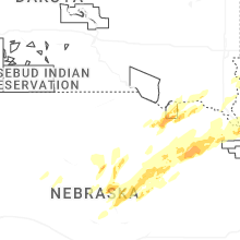
Nebraska
| Local Time | Report Details |
|---|---|
| 6:51 PM CDT | Ping Pong Ball sized hail reported near Verdigre, NE, 32.6 miles ENE of Oneill, NE |
| 7:30 PM CDT | Personal weather station measured wind gus in knox county NE, 36.6 miles E of Oneill, NE |
| 7:32 PM CDT | Half Dollar sized hail reported near Center, NE, 41.1 miles ENE of Oneill, NE |
| 7:35 PM CDT | Golf Ball sized hail reported near Center, NE, 41.5 miles E of Oneill, NE |
| 8:04 PM CDT | Quarter sized hail reported near Bloomfield, NE, 51.8 miles ENE of Oneill, NE |
| 8:06 PM CDT | Quarter sized hail reported near Bloomfield, NE, 52.2 miles ENE of Oneill, NE |
| 8:11 PM CDT | Accompanied by 1 inch hailstone in knox county NE, 52.6 miles ENE of Oneill, NE |
| 8:25 PM CDT | Quarter sized hail reported near Fordyce, NE, 64.2 miles ENE of Oneill, NE |
| 8:36 PM CDT | Ping Pong Ball sized hail reported near Fordyce, NE, 66.4 miles SSW of Sioux Falls, SD |
| 8:40 PM CDT | Quarter sized hail reported near Hartington, NE, 63.3 miles SSW of Sioux Falls, SD |
| 10:25 PM CDT | Quarter sized hail reported near North Loup, NE, 40.9 miles NNW of Grand Island, NE, x message had reports of quarter size hail over the recreation area. time estimated from radar. |
| 10:35 PM CDT | Tea Cup sized hail reported near Scotia, NE, 42.3 miles NNW of Grand Island, NE, photo of 3 inch hail 1 mile northwest of scotia. time estimated from radar. |
| 10:35 PM CDT | Baseball sized hail reported near Scotia, NE, 42.1 miles NNW of Grand Island, NE, facebook photo shows roughly baseball size hail. time estimated from radar. |
| 11:49 PM CDT | Personal weather station measured wind gus in madison county NE, 63.7 miles SE of Oneill, NE |
| 11:53 PM CDT | Personal weather station measured wind gus in madison county NE, 63.7 miles SE of Oneill, NE |
| 12:06 AM CDT | Personal weather station measured wind gus in madison county NE, 71.7 miles ESE of Oneill, NE |
| 12:06 AM CDT | Also reported that he was seeing tree damage from inside the hous in pierce county NE, 66.9 miles ESE of Oneill, NE |
| 12:08 AM CDT | Personal weather station measured wind gus in madison county NE, 70.5 miles ESE of Oneill, NE |
| 12:09 AM CDT | Ping Pong Ball sized hail reported near Norfolk, NE, 67.3 miles ESE of Oneill, NE |
| 12:10 AM CDT | Quarter sized hail reported near Norfolk, NE, 67.6 miles ESE of Oneill, NE |
| 12:10 AM CDT | Quarter sized hail reported near Norfolk, NE, 68.2 miles ESE of Oneill, NE, trained spotter report of hail up to quarter sized... wind driven. |
| 12:13 AM CDT | Personal weather station measured wind gus in madison county NE, 71.5 miles ESE of Oneill, NE |
| 12:13 AM CDT | Personal weather station measured wind gus in madison county NE, 67.8 miles ESE of Oneill, NE |
| 12:15 AM CDT | Storm damage reported in madison county NE, 70.7 miles ESE of Oneill, NE |
| 12:15 AM CDT | Half Dollar sized hail reported near Norfolk, NE, 68.1 miles ESE of Oneill, NE |
| 12:23 AM CDT | Hen Egg sized hail reported near Hoskins, NE, 73.7 miles ESE of Oneill, NE, reported as rural hoskins. time and location estimated by radar. |
| 12:25 AM CDT | As measured at a personal weather station. destroyed well-anchored car por in madison county NE, 67.4 miles ESE of Oneill, NE |
| 12:36 AM CDT | Personal weather statio in antelope county NE, 41.7 miles SE of Oneill, NE |
| 12:37 AM CDT | Quarter sized hail reported near Carroll, NE, 75.7 miles E of Oneill, NE |
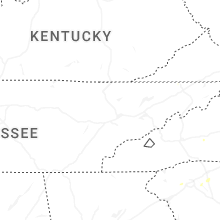
Tennessee
| Local Time | Report Details |
|---|---|
| 8:20 PM EDT | Quarter sized hail reported near Chuckey, TN, 38.5 miles SW of Bristol, TN, multiple reports via social media of quarter-sized hail in the cassi community just southeast of liberty... tn. |
| 8:30 PM EDT | Areas of trees and powerlines down in the tusculum to limestone area due to thunderstorm wind in greene county TN, 39.6 miles SW of Bristol, TN |
Iowa
| Local Time | Report Details |
|---|---|
| 9:45 PM CDT | Several large tree branches down across town ranging from 5 inches in diameter to as large as 13 inches in diamete in sioux county IA, 42.8 miles SE of Sioux Falls, SD |
| 1:30 AM CDT | Quarter sized hail reported near Sioux City, IA, 60.6 miles W of Storm Lake, IA |
| 1:31 AM CDT | Quarter sized hail reported near Sioux City, IA, 60.9 miles WSW of Storm Lake, IA |
| 1:35 AM CDT | Half Dollar sized hail reported near Sioux City, IA, 60.5 miles WSW of Storm Lake, IA, relayed through broadcast media with photo. |
| 1:35 AM CDT | Quarter sized hail reported near Sioux City, IA, 58.7 miles W of Storm Lake, IA |
| 2:10 AM CDT | Davis personal weather statio in osceola county IA, 50.1 miles ESE of Sioux Falls, SD |
| 2:17 AM CDT | Davis personal weather statio in osceola county IA, 48.4 miles NNW of Storm Lake, IA |
| 2:19 AM CDT | Davis personal weather statio in osceola county IA, 45.8 miles ESE of Sioux Falls, SD |
| 2:23 AM CDT | Metal storage shed destroyed. time estimated via rada in osceola county IA, 54 miles NNW of Storm Lake, IA |
| 2:34 AM CDT | Automated equipment at spencer airpor in clay county IA, 36.1 miles N of Storm Lake, IA |
| 2:35 AM CDT | Grain leg down on power lines and numerous branches down on city streets in lake park. also tree damage to a camper and truck on the south side of silver lake. no injur in dickinson county IA, 55.7 miles N of Storm Lake, IA |
| 2:35 AM CDT | Storm damage reported in dickinson county IA, 52.2 miles N of Storm Lake, IA |
| 2:36 AM CDT | Ambient personal weather statio in dickinson county IA, 48.6 miles N of Storm Lake, IA |
| 2:38 AM CDT | Davis personal weather statio in dickinson county IA, 43 miles N of Storm Lake, IA |
| 2:40 AM CDT | Ambient personal weather statio in dickinson county IA, 56.4 miles N of Storm Lake, IA |
| 2:59 AM CDT | At estherville airport aso in emmet county IA, 57.4 miles NNE of Storm Lake, IA |
Oklahoma
| Local Time | Report Details |
|---|---|
| 12:50 AM CDT | Cheyenne sit in roger mills county OK, 63.4 miles SSW of Woodward, OK |
Connect with Interactive Hail Maps