

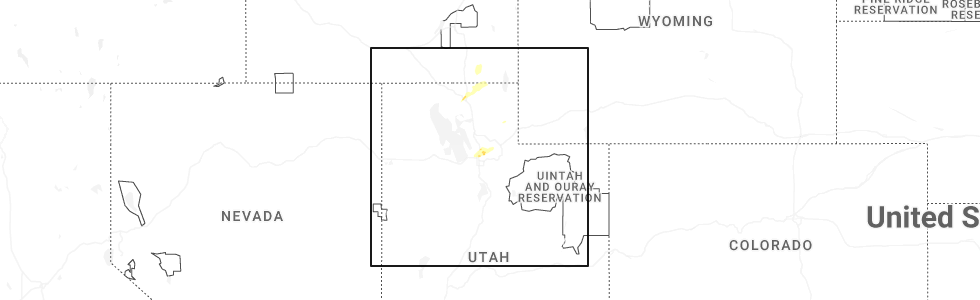
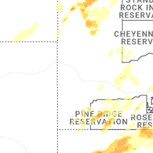
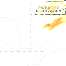
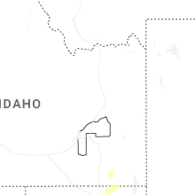
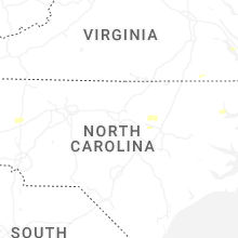
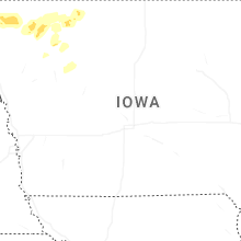
Hail Map for Saturday, June 27, 2026
Number of Impacted Households on 6/27/2026
0
Impacted by 1" or Larger Hail
0
Impacted by 1.75" or Larger Hail
0
Impacted by 2.5" or Larger Hail
Square Miles of Populated Area Impacted on 6/27/2026
0
Impacted by 1" or Larger Hail
0
Impacted by 1.75" or Larger Hail
0
Impacted by 2.5" or Larger Hail
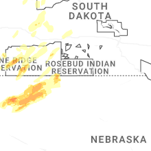
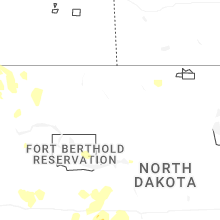
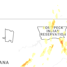
Cities Most Affected by Hail Storms of 6/27/2026
| Hail Size | Demographics of Zip Codes Affected | ||||||
|---|---|---|---|---|---|---|---|
| City | Count | Average | Largest | Pop Density | House Value | Income | Age |
| Buffalo, SD | 2 | 1.88 | 2.00 | 0 | $50k | $25.3k | 43.2 |
| Hammond, MT | 2 | 1.88 | 2.00 | 0 | $71k | $14.6k | 45.5 |
| Alzada, MT | 1 | 2.00 | 2.00 | 0 | $138k | $33.8k | 52.5 |
| Camp Crook, SD | 1 | 2.00 | 2.00 | 0 | $44k | $25.5k | 41.5 |
| Oral, SD | 1 | 1.75 | 1.75 | 2 | $60k | $29.5k | 50.5 |
| Baker, MT | 1 | 1.75 | 1.75 | 0 | $49k | $30.7k | 42.1 |
| Lambert, MT | 1 | 1.75 | 1.75 | 0 | $45k | $26.9k | 42.4 |
| Biddle, MT | 1 | 1.75 | 1.75 | 0 | $43k | $24.2k | 48.5 |
| Hay Springs, NE | 1 | 1.75 | 1.75 | 1 | $36k | $31.1k | 52.3 |
| Clearmont, WY | 1 | 1.75 | 1.75 | 0 | $65k | $35.2k | 43.8 |
| Oelrichs, SD | 1 | 1.75 | 1.75 | 0 | $25k | $29.5k | 50.6 |
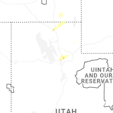
Hail and Wind Damage Spotted on 6/27/2026
Filter by Report Type:Hail ReportsWind Reports
States Impacted
Arkansas, Kentucky, Wyoming, Delaware, Missouri, Idaho, North Carolina, South Carolina, Illinois, Utah, Virginia, Montana, Indiana, South Dakota, North Dakota, Nebraska, Ohio, IowaArkansas
| Local Time | Report Details |
|---|---|
| 7:13 AM CDT | Tree damage; uproot and large branches broken; time estimated by rada in washington county AR, 41.2 miles N of Fort Smith, AR |
Kentucky
| Local Time | Report Details |
|---|---|
| 9:15 AM CDT | Trees down at yellow creek park. time estimated by rada in daviess county KY, 31.6 miles ESE of Evansville, IN |
| 3:00 PM CDT | Large branch (7-8 inch diameter) broken off of tree in central par in henderson county KY, 9.5 miles S of Evansville, IN |
| 4:05 PM CDT | Several trees down in mcquady between ky hwy 105 and 10 in breckinridge county KY, 48.9 miles WSW of Louisville, KY |
Wyoming
| Local Time | Report Details |
|---|---|
| 9:53 AM MDT | Asos station kbpi big piney airport (asos in sublette county WY, 82.1 miles NNW of Rock Springs, WY |
| 1:00 PM MDT | Quarter sized hail reported near Wyarno, WY, 66.9 miles WNW of Gillette, WY |
| 2:00 PM MDT | Golf Ball sized hail reported near Clearmont, WY, 47.3 miles WNW of Gillette, WY |
| 2:30 PM MDT | Mesonet station pc259 wyopo (pc in fremont county WY, 19.4 miles SW of Riverton, WY |
| 2:32 PM MDT | Mesonet station wy30 us30 nugget canyon (dot in lincoln county WY, 83.6 miles WNW of Rock Springs, WY |
| 2:46 PM MDT | Mesonet station shpw4 sharpnos in fremont county WY, 12.7 miles WSW of Riverton, WY |
| 2:53 PM MDT | Asos station klnd lander airport (asos in fremont county WY, 22.7 miles SW of Riverton, WY |
| 3:00 PM MDT | Mesonet station pc452 cottonwood merna (pc in sublette county WY, 98 miles W of Riverton, WY |
| 3:43 PM MDT | Mesonet station pc454 moss rock (pc). time estimate from rada in fremont county WY, 25.1 miles SW of Riverton, WY |
| 3:56 PM MDT | Mesonet station shpw4 sharpnose. time estimate from rada in fremont county WY, 12.7 miles WSW of Riverton, WY |
| 4:02 PM MDT | Mesonet station splw4 split rock creek. time estimate from rada in washakie county WY, 62.2 miles NE of Riverton, WY |
| 4:11 PM MDT | Asos station kriw riverton airport (asos in fremont county WY, 5.5 miles NW of Riverton, WY |
| 4:40 PM MDT | Mesonet station pc549 tisdale mtn (pc in johnson county WY, 45.1 miles NNW of Casper, WY |
| 4:40 PM MDT | Mesonet station pc462 irma lake (pc in park county WY, 102.6 miles NNW of Riverton, WY |
| 5:08 PM MDT | Mesonet station pc578 purdy east (pc). time estimate from rada in johnson county WY, 59.5 miles WSW of Gillette, WY |
| 5:11 PM MDT | Mesonet station pc631 stagner (pc). time estimate from rada in hot springs county WY, 31.3 miles N of Riverton, WY |
| 5:20 PM MDT | Mesonet station wy3 i-90 indian creek rd (dot in johnson county WY, 38 miles W of Gillette, WY |
| 5:30 PM MDT | Mesonet station pc456 badwater rd (pc in fremont county WY, 33.5 miles NE of Riverton, WY |
| 5:33 PM MDT | Mesonet station pc630 mcgarvin creek rd (pc). time estimate from rada in washakie county WY, 68.1 miles NNE of Riverton, WY |
| 5:47 PM MDT | Mesonet station pc457 hidden dome (pc). time estimate from rada in washakie county WY, 76.7 miles NNE of Riverton, WY |
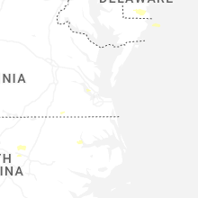
Delaware
| Local Time | Report Details |
|---|---|
| 1:23 PM EDT | Tree onto power lines resulting in several power outages. time estimated from rada in sussex county DE, 18.5 miles NNW of Ocean City, MD |
| 1:25 PM EDT | Large tree limbs down. time estimated from rada in sussex county DE, 17.3 miles NNW of Ocean City, MD |
Missouri
| Local Time | Report Details |
|---|---|
| 12:34 PM CDT | Several small tree limbs down in cape girardea in cape girardeau county MO, 0.6 miles NNW of Cape Girardeau, MO |
Idaho
| Local Time | Report Details |
|---|---|
| 12:45 PM MDT | Quarter sized hail reported near Clifton, ID, 90.6 miles S of Idaho Falls, ID, heavy rain ponding in pasture also. |
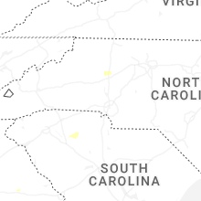
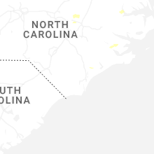
North Carolina
| Local Time | Report Details |
|---|---|
| 2:45 PM EDT | Tree in roadway at duke valentine wynne rd and perdues r in franklin county NC, 33.8 miles NE of Raleigh, NC |
| 2:50 PM EDT | Tree down on kennebec r in wake county NC, 14.1 miles SW of Raleigh, NC |
| 2:53 PM EDT | Power outage caused by downed trees near the intersection of avent ferry rd and new hill holleman r in wake county NC, 18.9 miles SW of Raleigh, NC |
| 2:55 PM EDT | Tree fell on power lines near s main st and w elm av in wake county NC, 14.5 miles SW of Raleigh, NC |
| 3:05 PM EDT | Tree in roadway at paul sledge rd & sledge r in franklin county NC, 27.3 miles ENE of Raleigh, NC |
| 3:05 PM EDT | Tree down in road on 100 block of rawhide dr in louisbur in franklin county NC, 28.6 miles ENE of Raleigh, NC |
| 3:05 PM EDT | Pictures show a large tree down near the intersection of thomas gay rd and seven paths rd in spring hope... nc. nearby residence saw damage to siding and front porc in franklin county NC, 29.4 miles ENE of Raleigh, NC |
| 3:07 PM EDT | Downed trees caused a large power outage around the bentwinds... woodlake estates... ballentine... and mill ridge neighborhoods northeast of fuquay-varina. over 2...000 in wake county NC, 13.5 miles SSW of Raleigh, NC |
| 3:20 PM EDT | Tree down near old stage rd and vandora spring in wake county NC, 6.6 miles S of Raleigh, NC |
| 3:20 PM EDT | Tree down on buffaloe r in wake county NC, 7.3 miles S of Raleigh, NC |
| 3:24 PM EDT | Downed trees caused a large power outage around the middlesex area. over 1...000 customers without powe in nash county NC, 24.9 miles E of Raleigh, NC |
| 3:25 PM EDT | Downed trees caused a large power outage near the intersection of ackerman road and white oak road. over 2...000 customers without powe in wake county NC, 8.7 miles SSE of Raleigh, NC |
| 3:25 PM EDT | Extensive tree damage at powell rd and north main street in drexe in burke county NC, 57.2 miles NW of Charlotte, NC |
| 3:28 PM EDT | Multiple trees and power lines down between drexel and valdes in burke county NC, 55.5 miles NW of Charlotte, NC |
| 3:39 PM EDT | Social media picture of a tree down in rutherfordto in rutherford county NC, 51.9 miles NE of Greenville, SC |
| 3:40 PM EDT | Social media report of trees down between rhodhiss and granite fall in caldwell county NC, 50.9 miles NW of Charlotte, NC |
| 3:40 PM EDT | Trees down near bowman lowman r in burke county NC, 48.6 miles NW of Charlotte, NC |
| 3:43 PM EDT | Downed trees caused a large power outage just east of archer lodge along covered bridge road. over 2...000 customers without powe in johnston county NC, 16.7 miles ESE of Raleigh, NC |
| 3:44 PM EDT | Downed trees caused a large power outage near the intersection of buffalo road and hidden acres drive. around 600 customers without powe in johnston county NC, 20.2 miles ESE of Raleigh, NC |
| 3:44 PM EDT | Social media picture of a tree down along hall dairy r in catawba county NC, 40.4 miles NNW of Charlotte, NC |
| 3:45 PM EDT | Multiple power outages from fallen trees in northeast catawba county in the vicinity of oxford school rd and rock barn r in catawba county NC, 40.8 miles NNW of Charlotte, NC |
| 3:46 PM EDT | Multiple large trees down on structures and powerlines on oxford school roa in catawba county NC, 41.4 miles NNW of Charlotte, NC |
| 3:48 PM EDT | Trees and power lines down in the 1200 block of sharon school r in iredell county NC, 41.4 miles NNW of Charlotte, NC |
| 3:55 PM EDT | Trees down in the 200 block of mount bethel roa in iredell county NC, 48.9 miles N of Charlotte, NC |
| 3:59 PM EDT | Tree down near the 8500 block of watson grove roa in wilson county NC, 31.2 miles ESE of Raleigh, NC |
| 4:02 PM EDT | Tree down across i-40 blocking both westbound lane in iredell county NC, 41.2 miles N of Charlotte, NC |
| 4:04 PM EDT | Several trees down on utility equipment in the forest city are in rutherford county NC, 54.3 miles NE of Greenville, SC |
| 4:09 PM EDT | Tree down on utility equipmen in cleveland county NC, 46.6 miles W of Charlotte, NC |
| 4:22 PM EDT | Tree down near the intersection of tartts mill road and landfill roa in wilson county NC, 45.3 miles E of Raleigh, NC |
| 4:22 PM EDT | Tree down near the intersection of us-264 alt e and landfill roa in wilson county NC, 44.9 miles E of Raleigh, NC |
| 4:31 PM EDT | Tree down near the intersection of piney grove church road and gum pond roa in wilson county NC, 51.3 miles E of Raleigh, NC |
| 6:00 PM EDT | *** 1 inj *** powerlines down on fence and tree on house. non-critical injury to occupan in union county NC, 28.2 miles SE of Charlotte, NC |
| 6:15 PM EDT | Corrects previous tstm wnd dmg report from 4 nnw trinity. tree down on roadwa in union county NC, 26.9 miles SE of Charlotte, NC |
| 6:15 PM EDT | Corrects previous tstm wnd dmg report from 4 s waxhaw. trees down in yar in union county NC, 24.9 miles SSE of Charlotte, NC |
| 6:15 PM EDT | Trees down in roadwa in union county NC, 20.7 miles SSE of Charlotte, NC |
| 6:15 PM EDT | Corrects previous tstm wnd dmg report from 5 s waxhaw. trees down on powerline in union county NC, 26.2 miles S of Charlotte, NC |
| 6:15 PM EDT | Trees and powerlines down on roadwa in union county NC, 26.6 miles SSE of Charlotte, NC |
South Carolina
| Local Time | Report Details |
|---|---|
| 2:52 PM EDT | Social media report of trees down along hwy 123 in the liberty are in pickens county SC, 5.3 miles SW of Greenville, SC |
| 3:18 PM EDT | Social media picture of a large tree down along north main s in greenville county SC, 12.3 miles ENE of Greenville, SC |
| 3:19 PM EDT | Trees down in the ashford ave are in greenville county SC, 12.8 miles ENE of Greenville, SC |
| 3:22 PM EDT | Social media picture of a snapped tree in the wade hampton are in greenville county SC, 16.1 miles ENE of Greenville, SC |
| 3:34 PM EDT | Social media picture of a tree down in taylor in greenville county SC, 19.2 miles ENE of Greenville, SC |
| 3:39 PM EDT | Social media report of a tree down across stenhouse r in greenville county SC, 19.2 miles ESE of Greenville, SC |
| 3:58 PM EDT | Aiken county dispatch reports trees down on a power line causing a fire near the intersection of kathwood rd and old jackson hw in aiken county SC, 12.6 miles SE of Augusta, GA |
| 4:14 PM EDT | Multiple social media pictures and reports of trees and power lines down in walhall in oconee county SC, 26.6 miles W of Greenville, SC |
| 4:14 PM EDT | Trees down on power lines in the walhalla are in oconee county SC, 28.2 miles W of Greenville, SC |
| 4:34 PM EDT | Tree downed in the clinton are in laurens county SC, 47.6 miles ESE of Greenville, SC |
| 4:48 PM EDT | Numerous trees and power lines down across both the city and county of unio in union county SC, 55 miles SW of Charlotte, NC |
| 4:50 PM EDT | Large tree down on bermuda driv in union county SC, 54.7 miles E of Greenville, SC |
| 5:23 PM EDT | Dorchester county emergency management reported power lines down at the 3000 block of mcalhany roa in dorchester county SC, 39.8 miles W of Charleston, SC |
Illinois
| Local Time | Report Details |
|---|---|
| 2:00 PM CDT | Photo of tree damage by two homes in stoy. video of funnel cloud at stoy... possible tornad in crawford county IL, 44.3 miles SE of Mattoon, IL |
| 2:48 PM CDT | Tree down on county road 450n near cowlin in edwards county IL, 31.9 miles NW of Evansville, IN |
| 6:20 PM CDT | Tree blown down on mount pleasant r in massac county IL, 53.5 miles E of Cape Girardeau, MO |
Utah
| Local Time | Report Details |
|---|---|
| 1:03 PM MDT | Pacificorp crow mountain measured a 62mph gus in cache county UT, 76.7 miles N of Salt Lake City, UT |
Virginia
| Local Time | Report Details |
|---|---|
| 3:15 PM EDT | Tree down near newsoms... va. time estimated via rada in southampton county VA, 60.5 miles W of Virginia Beach, VA |
| 3:49 PM EDT | Tree down on hill cross roa in charlotte county VA, 65.4 miles WSW of Richmond, VA |
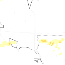
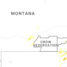
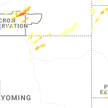
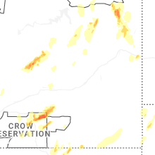
Montana
| Local Time | Report Details |
|---|---|
| 1:47 PM MDT | Quarter sized hail reported near Bridger, MT, 38.2 miles SSW of Billings, MT |
| 2:25 PM MDT | Quarter sized hail reported near Circle, MT, 69.5 miles SE of Glasgow, MT, spotter estimates quarter sized hail with heavy rainfall. |
| 3:38 PM MDT | Quarter sized hail reported near Garryowen, MT, 54.1 miles ESE of Billings, MT |
| 4:02 PM MDT | Golf Ball sized hail reported near Biddle, MT, 56.4 miles N of Gillette, WY |
| 4:17 PM MDT | Hen Egg sized hail reported near Alzada, MT, 60.4 miles NNE of Gillette, WY |
| 4:18 PM MDT | Quarter sized hail reported near Ekalaka, MT, 71.8 miles ESE of Miles City, MT |
| 4:54 PM MDT | Quarter sized hail reported near Scobey, MT, 65.6 miles ENE of Glasgow, MT, social media reports of hail the size of quarters. |
| 5:28 PM MDT | Golf Ball sized hail reported near Baker, MT, 88.7 miles ESE of Miles City, MT |
| 5:30 PM MDT | Quarter sized hail reported near Scobey, MT, 69.4 miles NE of Glasgow, MT, social media report of quarter size hail. |
| 5:38 PM MDT | Quarter sized hail reported near Baker, MT, 84.1 miles E of Miles City, MT |
| 5:45 PM MDT | Quarter sized hail reported near Wibaux, MT, 84.9 miles SSW of Williston, ND, trained spotter report of hail up to the size of quarters. |
| 5:54 PM MDT | Ping Pong Ball sized hail reported near Poplar, MT, 62.6 miles WSW of Williston, ND, social media report of hail up to 1.5 inches in diameter. |
| 5:56 PM MDT | Asos station kbhk bake in fallon county MT, 76.5 miles E of Miles City, MT |
| 6:00 PM MDT | Mesonet station mteka baker mt-7 mp 14. in fallon county MT, 71.2 miles ESE of Miles City, MT |
| 6:15 PM MDT | Mesonet observatio in wibaux county MT, 79 miles ENE of Miles City, MT |
| 6:22 PM MDT | Golf Ball sized hail reported near Lambert, MT, 63.4 miles WSW of Williston, ND |
| 6:35 PM MDT | Hen Egg sized hail reported near Hammond, MT, 68.7 miles NNE of Gillette, WY |
| 6:40 PM MDT | Golf Ball sized hail reported near Hammond, MT, 73.3 miles NNE of Gillette, WY |
| 7:30 PM MDT | Corrects previous tstm wnd gst report from 2 e enid. mesonet observation thunderstorm wind gus in richland county MT, 60 miles WSW of Williston, ND |
| 7:45 PM MDT | Mesonet station mtm28 5.2 e hoyt (mt-meso in dawson county MT, 62.8 miles NE of Miles City, MT |
| 7:56 PM MDT | Mesonet observation thunderstorm wind gus in richland county MT, 60 miles WSW of Williston, ND |
Indiana
| Local Time | Report Details |
|---|---|
| 3:05 PM CDT | Several trees/powerlines down in evansville. 62 mph wind gust at 312 pm in newburg in vanderburgh county IN, 1.7 miles WNW of Evansville, IN |
| 5:08 PM EDT | Tree down across both lanes of traffic on saint anthony r in dubois county IN, 46.8 miles ENE of Evansville, IN |
| 5:30 PM EDT | Large tree blocking both lanes of traffic on south kings ridge roa in dubois county IN, 53.2 miles ENE of Evansville, IN |
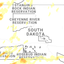
South Dakota
| Local Time | Report Details |
|---|---|
| 5:10 PM MDT | Large tree down in the spring brook acres area. time estimate in pennington county SD, 3.4 miles SW of Rapid City, SD |
| 5:12 PM MDT | Hen Egg sized hail reported near Camp Crook, SD, 105.3 miles ESE of Miles City, MT, measured with a ruler along river rd. hail of various sizes fell from about 512 pm to 520 pm. |
| 5:17 PM MDT | Golf Ball sized hail reported near Oral, SD, 49.4 miles S of Rapid City, SD, reported via social media. |
| 5:20 PM MDT | Storm damage reported in pennington county SD, 8.8 miles ESE of Rapid City, SD |
| 5:20 PM MDT | Large tree limbs down. time estimate in pennington county SD, 2.1 miles NNE of Rapid City, SD |
| 5:21 PM MDT | Storm damage reported in pennington county SD, 8.8 miles ESE of Rapid City, SD |
| 5:29 PM MDT | Hen Egg sized hail reported near Buffalo, SD, 106.4 miles NNW of Rapid City, SD, falling now along highway 20. reported via spotter network. |
| 5:35 PM MDT | Storm damage reported in pennington county SD, 15.2 miles E of Rapid City, SD |
| 6:00 PM MDT | Storm damage reported in harding county SD, 109.7 miles ESE of Miles City, MT |
| 6:02 PM MDT | Golf Ball sized hail reported near Oelrichs, SD, 71.2 miles S of Rapid City, SD, measured with calipers along us-385. |
| 6:07 PM MDT | Storm damage reported in harding county SD, 106 miles N of Rapid City, SD |
| 6:15 PM MDT | Storm damage reported in harding county SD, 124 miles ESE of Miles City, MT |
| 6:16 PM MDT | Quarter sized hail reported near Buffalo Gap, SD, 45.5 miles SSE of Rapid City, SD |
| 6:25 PM MDT | Storm damage reported in harding county SD, 124 miles ESE of Miles City, MT |
| 6:28 PM MDT | Golf Ball sized hail reported near Buffalo, SD, 101.6 miles N of Rapid City, SD, along highway 20. reported via spotter network. |
| 6:29 PM MDT | Measured on a personal weather statio in oglala lakota county SD, 53.1 miles SE of Rapid City, SD |
| 6:30 PM MDT | Storm damage reported in pennington county SD, 36.4 miles E of Rapid City, SD |
| 6:50 PM MDT | Storm damage reported in pennington county SD, 51.3 miles ESE of Rapid City, SD |
| 6:51 PM MDT | Storm damage reported in jackson county SD, 61.3 miles E of Rapid City, SD |
| 7:01 PM MDT | Storm damage reported in jackson county SD, 61.3 miles E of Rapid City, SD |
| 7:04 PM MDT | Measured on a personal weather statio in meade county SD, 49.9 miles NE of Rapid City, SD |
| 7:59 PM MDT | Storm damage reported in haakon county SD, 44 miles WSW of Pierre, SD |
| 10:59 PM CDT | From the sddot sit in walworth county SD, 71.6 miles W of Aberdeen, SD |
| 12:14 AM CDT | Storm damage reported in hand county SD, 68.1 miles E of Pierre, SD |
| 12:16 AM CDT | Storm damage reported in tripp county SD, 40.2 miles ENE of Valentine, NE |
| 12:25 AM CDT | Storm damage reported in spink county SD, 37.6 miles S of Aberdeen, SD |
| 12:52 AM CDT | Time estimate in brown county SD, 2.3 miles NE of Aberdeen, SD |
| 1:00 AM CDT | Mesonet station 307 sd rwis dalla in gregory county SD, 59.1 miles ENE of Valentine, NE |
| 1:20 AM CDT | Mesonet station gots2 groton 9 nne (sd mesonet in brown county SD, 23.5 miles ENE of Aberdeen, SD |
| 1:30 AM CDT | Personal weather statio in gregory county SD, 52.8 miles NNW of Oneill, NE |
| 1:43 AM CDT | Personal weather statio in charles mix county SD, 59.6 miles NNW of Oneill, NE |
| 1:51 AM CDT | Mesonet station 244 sd rwis ft. randall da in gregory county SD, 41.1 miles N of Oneill, NE |
| 2:25 AM CDT | Personal weather station 1 ene of wagner s in charles mix county SD, 46.9 miles NNE of Oneill, NE |
| 2:35 AM CDT | Mesonet station 324 sd rwis wagne in charles mix county SD, 50.4 miles NNE of Oneill, NE |
| 2:39 AM CDT | South dakota state mesonet 3 e avo in bon homme county SD, 50.4 miles NE of Oneill, NE |
| 2:51 AM CDT | Mesonet station 304 sd rwis corsic in douglas county SD, 64.8 miles N of Oneill, NE |
| 3:39 AM CDT | Storm damage reported in mccook county SD, 28.3 miles W of Sioux Falls, SD |
| 4:22 AM CDT | Storm damage reported in minnehaha county SD, 2.6 miles NNW of Sioux Falls, SD |
| 4:27 AM CDT | Storm damage reported in clay county SD, 36.6 miles SSW of Sioux Falls, SD |
| 4:34 AM CDT | Mesonet station 17 sd rwis dell rapid in minnehaha county SD, 19.1 miles N of Sioux Falls, SD |
| 4:40 AM CDT | Storm damage reported in lincoln county SD, 16.6 miles SSW of Sioux Falls, SD |
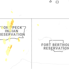
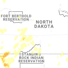
North Dakota
| Local Time | Report Details |
|---|---|
| 5:38 PM MDT | Report from private weather statio in golden valley county ND, 84.8 miles S of Williston, ND |
| 5:40 PM MDT | Quarter sized hail reported near Rhame, ND, 97.1 miles ESE of Miles City, MT, emergency manager relayed report of 1 inch hail; also reports rain and winds up to 25 mph. |
| 6:16 PM MDT | Deputy reports estimated 70 mph winds with heavy rain; no hail presen in bowman county ND, 103.1 miles E of Miles City, MT |
| 6:17 PM MDT | 60 mph winds measured by local deputy; heavy rain... no hail presen in bowman county ND, 103.6 miles E of Miles City, MT |
| 6:17 PM MDT | 61 mph wind measured by local deputy; heavy rain with no hail presen in bowman county ND, 99.2 miles E of Miles City, MT |
| 6:25 PM MDT | 82 mph wind gust measured at ndawn 4w bowma in bowman county ND, 114.8 miles E of Miles City, MT |
| 6:28 PM MDT | Report from private weather statio in dunn county ND, 80.1 miles SSE of Williston, ND |
| 6:29 PM MDT | Bowman regional airport awos measures 69 mph gus in bowman county ND, 123.2 miles E of Miles City, MT |
| 6:37 PM MDT | 68 mph wind gust measured at amidon 1ne ndaw in slope county ND, 114.7 miles S of Williston, ND |
| 6:43 PM MDT | 68 mph gust at 10 m measured from 10n sentinel butte ndaw in golden valley county ND, 74.8 miles S of Williston, ND |
| 6:45 PM MDT | 78 mph gust measured at 10m at 4ne mosher ndaw in golden valley county ND, 65.2 miles S of Williston, ND |
| 6:51 PM MDT | Mesonet station ew7744 medor in golden valley county ND, 84.8 miles S of Williston, ND |
| 6:52 PM MDT | 86 mph gust at 10m measured at 4ne mosher ndaw in golden valley county ND, 65.2 miles S of Williston, ND |
| 7:18 PM MDT | Asos station kdik dickinson airpor in stark county ND, 95.9 miles W of Bismarck, ND |
| 7:30 PM MDT | Mesonet station amdn8 sand cree in slope county ND, 110.4 miles S of Williston, ND |
| 7:30 PM MDT | 80 mph gust at 10m recorded at manning 4sw ndaw in dunn county ND, 75.7 miles SSE of Williston, ND |
| 8:45 PM CDT | Mesonet station 321480 6 nnw charbonneau (ndawn in mckenzie county ND, 16.3 miles SSW of Williston, ND |
| 8:45 PM CDT | 67 mph wind gust at 10m recorded at buford 3se ndaw in williams county ND, 18.8 miles SW of Williston, ND |
| 9:06 PM CDT | 72 mph gust at 3m measured at pioneer ndaw in williams county ND, 15.4 miles WNW of Williston, ND |
| 9:11 PM CDT | Report from private weather statio in williams county ND, 17.3 miles NW of Williston, ND |
| 9:15 PM CDT | Awos station kxwa williston airpor in williams county ND, 10.4 miles NW of Williston, ND |
| 9:20 PM CDT | Emergency manager reports power lines down in williston. additionally reports a damage to plastic components at the top of a tall car dealership sign. a wind gust of 70 in williams county ND, 2.2 miles W of Williston, ND |
| 9:29 PM CDT | Report from private weather statio in williams county ND, 35.8 miles NNW of Williston, ND |
| 9:31 PM CDT | Report from private weather statio in williams county ND, 28.7 miles N of Williston, ND |
| 9:40 PM CDT | 67 mph gust at 10m measured at 8n grenora ndaw in divide county ND, 42.7 miles NNW of Williston, ND |
| 8:44 PM MDT | Storm damage reported in mercer county ND, 56.8 miles NW of Bismarck, ND |
| 9:50 PM CDT | 62 mph wind gust at 3m measured at rat lake 4nw ndaw in mountrail county ND, 42.8 miles E of Williston, ND |
| 10:00 PM CDT | 79 mph gust at 10m measured at fortuna 4n ndawn; 72 mph gusts at 3 in divide county ND, 56.8 miles N of Williston, ND |
| 10:22 PM CDT | 61 mph wind gust at 10m recorded at new salem 6se ndaw in morton county ND, 26.7 miles W of Bismarck, ND |
| 10:24 PM CDT | Report from private weather statio in morton county ND, 31.8 miles SW of Bismarck, ND |
| 11:19 PM CDT | 70 mph wind gust at 10m measured at pickardville 6sw ndawn; 69 mph recorded at 3 in sheridan county ND, 42.8 miles N of Bismarck, ND |
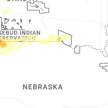
Nebraska
| Local Time | Report Details |
|---|---|
| 6:26 PM MDT | Quarter sized hail reported near Hemingford, NE, 43.6 miles NE of Scottsbluff, NE |
| 7:11 PM MDT | Golf Ball sized hail reported near Hay Springs, NE, 67.4 miles NE of Scottsbluff, NE, time estimated from radar. |
| 7:27 PM MDT | Half Dollar sized hail reported near Hay Springs, NE, 63.2 miles NE of Scottsbluff, NE |
| 8:58 PM MDT | Nebraska mesone in cherry county NE, 62 miles WSW of Valentine, NE |
| 9:32 PM MDT | Nebraska mesone in cherry county NE, 36.5 miles W of Valentine, NE |
| 11:37 PM CDT | Nebraska mesone in cherry county NE, 18.3 miles ENE of Valentine, NE |
| 12:59 AM CDT | Nebraska mesone in keya paha county NE, 40.8 miles NW of Oneill, NE |
| 1:01 AM CDT | Nebraska mesone in keya paha county NE, 40.8 miles NW of Oneill, NE |
| 4:01 AM CDT | Public weather station reported gust to 63 mp in knox county NE, 62.3 miles SW of Sioux Falls, SD |
Ohio
| Local Time | Report Details |
|---|---|
| 12:46 AM EDT | Tree down in the 1100 block of west pleasant street. time estimated from rada in clark county OH, 44 miles W of Columbus, OH |
| 12:46 AM EDT | Tree down in the 700 block of leffel lane. time estimate from rada in clark county OH, 42.1 miles W of Columbus, OH |
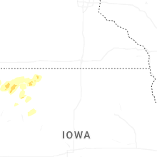
Iowa
| Local Time | Report Details |
|---|---|
| 5:35 AM CDT | Quarter sized hail reported near Hull, IA, 38.6 miles SE of Sioux Falls, SD |
| 6:09 AM CDT | Quarter sized hail reported near Sanborn, IA, 44.1 miles NNW of Storm Lake, IA |
| 6:34 AM CDT | Asos station kspw spencer municipal airpor in clay county IA, 36.1 miles N of Storm Lake, IA |
Connect with Interactive Hail Maps