

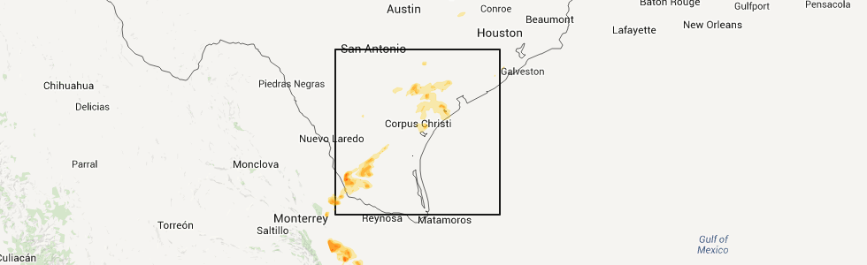
Hail Map for Sunday, April 15, 2012
Number of Impacted Households on 4/15/2012
0
Impacted by 1" or Larger Hail
0
Impacted by 1.75" or Larger Hail
0
Impacted by 2.5" or Larger Hail
Square Miles of Populated Area Impacted on 4/15/2012
0
Impacted by 1" or Larger Hail
0
Impacted by 1.75" or Larger Hail
0
Impacted by 2.5" or Larger Hail


Cities Most Affected by Hail Storms of 4/15/2012
| Hail Size | Demographics of Zip Codes Affected | ||||||
|---|---|---|---|---|---|---|---|
| City | Count | Average | Largest | Pop Density | House Value | Income | Age |
| Goliad, TX | 2 | 1.75 | 1.75 | 6 | $52k | $32.6k | 45.6 |
| Gravois Mills, MO | 1 | 1.75 | 1.75 | 75 | $111k | $32.0k | 57.1 |
| Zapata, TX | 1 | 1.75 | 1.75 | 22 | $46k | $24.6k | 27.9 |
Hail and Wind Damage Spotted on 4/15/2012
Filter by Report Type:Hail ReportsWind Reports
Kansas
| Local Time | Report Details |
|---|---|
| 7:00 AM CDT | Winds estimated at 50 to 60 miles per hou in cherokee county KS, 42 miles SSE of Chanute, KS |
| 7:14 AM CDT | 8 inch tree snapped...roof off of building in cherokee county KS, 45.4 miles SE of Chanute, KS |
Oklahoma
| Local Time | Report Details |
|---|---|
| 9:20 AM CDT | Path of significant tree d in cherokee county OK, 41.5 miles NW of Fort Smith, AR |
| 9:25 AM CDT | Tree and shed damage on east side of tenkiller lake off of carters landing rd. possible tornado. time estimated by rada in cherokee county OK, 41.5 miles NW of Fort Smith, AR |
| 9:25 AM CDT | Tree damage on east side of tenkiller lake. possible tornado. time estimated by rada in cherokee county OK, 41.5 miles NW of Fort Smith, AR |
| 9:30 AM CDT | At hwy 51 and county line. mobile in adair county OK, 41.4 miles NNW of Fort Smith, AR |
Illinois
| Local Time | Report Details |
|---|---|
| 9:37 AM CDT | 2 aircraft damaged at the airport. time estimated. no further details available at this tim in rock island county IL, 70.7 miles ESE of Cedar Rapids, IA |
| 6:55 PM CDT | Several trees with tops ripped off...large machine shed and a couple of smaller sheds blown down...several trees and power lines blown down...damage is along illinois r in pike county IL, 70.6 miles SSE of Kahoka, MO |
| 6:55 PM CDT | Several trees with tops ripped off...large machine shed and a couple of smaller sheds blown down...several trees and power lines blown dow in pike county IL, 70.6 miles SSE of Kahoka, MO |
| 7:55 PM CDT | Dispatch reports that a tree had to be removed from a road in elsa in jersey county IL, 23.7 miles NNW of Saint Louis, MO |
| 8:05 PM CDT | Dispatch reports that a tree fell down in jerseyvill in jersey county IL, 34.3 miles N of Saint Louis, MO |
| 11:50 PM CDT | Late report of limbs down in fairfield. part of one tree down on a garag in wayne county IL, 51.9 miles WNW of Evansville, IN |
| 12:55 AM CDT | Storm damage reported in crawford county IL, 47.1 miles SE of Mattoon, IL |
Arkansas
| Local Time | Report Details |
|---|---|
| 10:03 AM CDT | Large tree limbs down over north road and a large tree across a county road. time is radar estimate in washington county AR, 41.2 miles N of Fort Smith, AR |
| 10:08 AM CDT | Tree damage. possible brief tornado touchdown. time estimated by rada in washington county AR, 39 miles N of Fort Smith, AR |
| 10:15 AM CDT | 2-3 inch tree limbs down. time radar estimate in washington county AR, 39 miles N of Fort Smith, AR |
| 6:09 PM CDT | Trees were blown down onto power lines on arkansas 356. there is a possibility that this was a brief tornado. the time was approximated based on rada in van buren county AR, 49.8 miles N of Little Rock, AR |
| 6:18 PM CDT | A power pole was snapped and some trees and power lines were blown down on river ridge road near sale in saline county AR, 18.2 miles WSW of Little Rock, AR |
South Dakota
| Local Time | Report Details |
|---|---|
| 11:10 AM CDT | Quarter sized hail reported near Mitchell, SD, 66.4 miles WNW of Sioux Falls, SD, mostly dime size but a few quarter size. |
| 11:28 AM CDT | Quarter sized hail reported near Mitchell, SD, 66.1 miles WNW of Sioux Falls, SD, mostly nickel size but a few quarters |
| 11:50 AM CDT | Quarter sized hail reported near Artesian, SD, 68.6 miles WNW of Sioux Falls, SD, mostly dime size but a few as big as quarters |
| 3:30 PM CDT | Quarter sized hail reported near Brookings, SD, 55.8 miles N of Sioux Falls, SD |
| 4:10 PM CDT | Quarter sized hail reported near Brookings, SD, 55.8 miles N of Sioux Falls, SD |
| 4:56 PM CDT | Peak wind at sisseton asos 59mph in roberts county SD, 71.1 miles ENE of Aberdeen, SD |
Missouri
| Local Time | Report Details |
|---|---|
| 1:50 PM CDT | Quarter sized hail reported near Cassville, MO, 49.8 miles SW of Springfield, MO |
| 1:53 PM CDT | Quarter sized hail reported near Cassville, MO, 48.5 miles SW of Springfield, MO |
| 4:11 PM CDT | Quarter sized hail reported near Sunrise Beach, MO, 61.9 miles SSW of Columbia, MO |
| 4:15 PM CDT | Golf Ball sized hail reported near Gravois Mills, MO, 57.9 miles SSW of Columbia, MO |
| 4:31 PM CDT | Large cedar tree was blown over onto highway c near intersection with highway c in moniteau county MO, 35.8 miles SSW of Columbia, MO |
| 6:05 PM CDT | A couple of trees down over roadwa in dent county MO, 10.3 miles S of Salem, MO |
| 6:05 PM CDT | Shed blown around and tree down over road on county road 224 in dent county MO, 3.4 miles WNW of Salem, MO |
| 7:33 PM CDT | Storm damage reported in st. louis county MO, 23.4 miles W of Saint Louis, MO |
| 7:34 PM CDT | Large tree limb blown down onto power line in st. charles county MO, 27 miles WNW of Saint Louis, MO |
| 7:39 PM CDT | At cave springs and mexico roa in st. charles county MO, 22.9 miles WNW of Saint Louis, MO |
| 7:45 PM CDT | 12 inch diameter tree snapped off at its trunk in st. charle in st. charles county MO, 20.6 miles WNW of Saint Louis, MO |
| 7:52 PM CDT | Fire dispatch reports that a power line was blown over with storms. time estimated with rada in jefferson county MO, 23.2 miles SSW of Saint Louis, MO |
Minnesota
| Local Time | Report Details |
|---|---|
| 3:05 PM CDT | Quarter sized hail reported near Holland, MN, 43.8 miles NE of Sioux Falls, SD, hail covered the ground. most stones were marble size with a few quarter size. |
| 3:28 PM CDT | Quarter sized hail reported near Tyler, MN, 46.5 miles SSW of Montevideo, MN, ground was white with hail up to the size of quarters. |
| 4:10 PM CDT | Quarter sized hail reported near Minneota, MN, 29.7 miles SSW of Montevideo, MN |
| 5:50 PM CDT | Quarter sized hail reported near Glencoe, MN, 45.8 miles WSW of Minneapolis, MN, hail on the northwest side of the city |
Texas
| Local Time | Report Details |
|---|---|
| 5:43 PM CDT | Golf Ball sized hail reported near Goliad, TX, 67.2 miles N of Corpus Christi, TX, golf ball sized hail reported off farm-to-market road 1726. |
| 6:10 PM CDT | Ping Pong Ball sized hail reported near Goliad, TX, 62.9 miles N of Corpus Christi, TX, ping pong ball sized hail reported off farm-to-market road 1726. |
| 6:25 PM CDT | Golf Ball sized hail reported near Goliad, TX, 60.2 miles N of Corpus Christi, TX, spotter reported golf ball sized hail in goliad. |
| 6:44 PM CDT | Quarter sized hail reported near Goliad, TX, 63 miles N of Corpus Christi, TX, spotter reported quarter sized hail in the town of fannin. |
| 7:31 PM CDT | Quarter sized hail reported near Victoria, TX, 74.2 miles NNE of Corpus Christi, TX, stripes convenience store employee reported quarter sized hail at u.s. 59 and north laurent st. |
| 8:29 PM CDT | Quarter sized hail reported near Concepcion, TX, 59 miles WSW of Corpus Christi, TX, public near cruz calle reported quarter sized hail. |
| 8:41 PM CDT | Quarter sized hail reported near Zapata, TX, 49.1 miles SSE of Laredo, TX, quarter sized hail reported by storm spotter. |
| 9:10 PM CDT | Golf Ball sized hail reported near Zapata, TX, 57.4 miles SSE of Laredo, TX, public report in morales-sanchez community of golf ball size hail. |
| 10:04 PM CDT | Quarter sized hail reported near Roma, TX, 69.4 miles SSE of Laredo, TX, quarter size hail and 50 to 60 mph winds between falcon and lopeno. |
| 12:54 AM CDT | Half Dollar sized hail reported near Corpus Christi, TX, 17.6 miles SE of Corpus Christi, TX, hail broke flood lights at the island italian restaurant on north padre island |
| 5:44 AM CDT | Damage to cotton gin near gregory along with powerlines dow in san patricio county TX, 11 miles NE of Corpus Christi, TX |
Connect with Interactive Hail Maps