

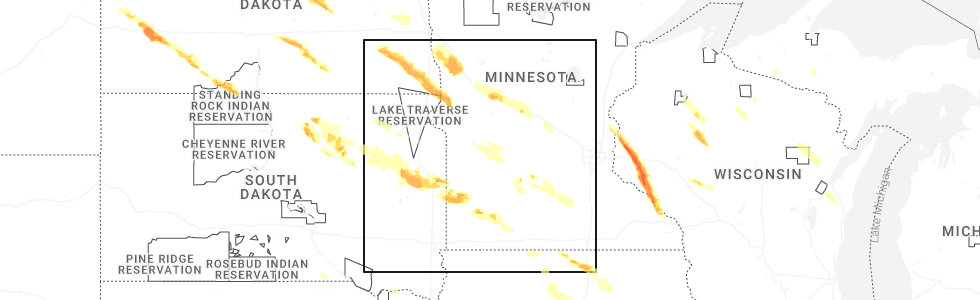
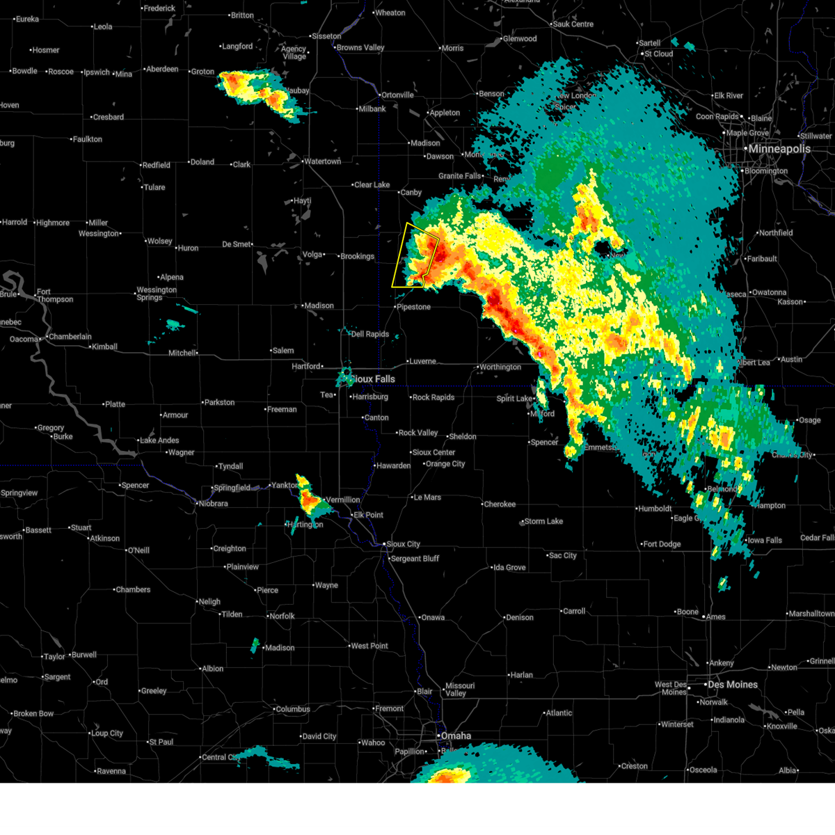
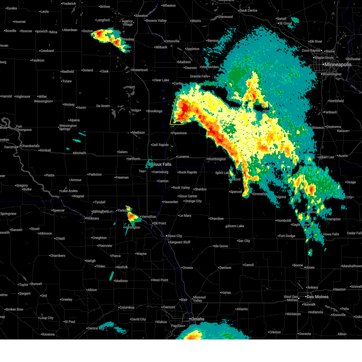
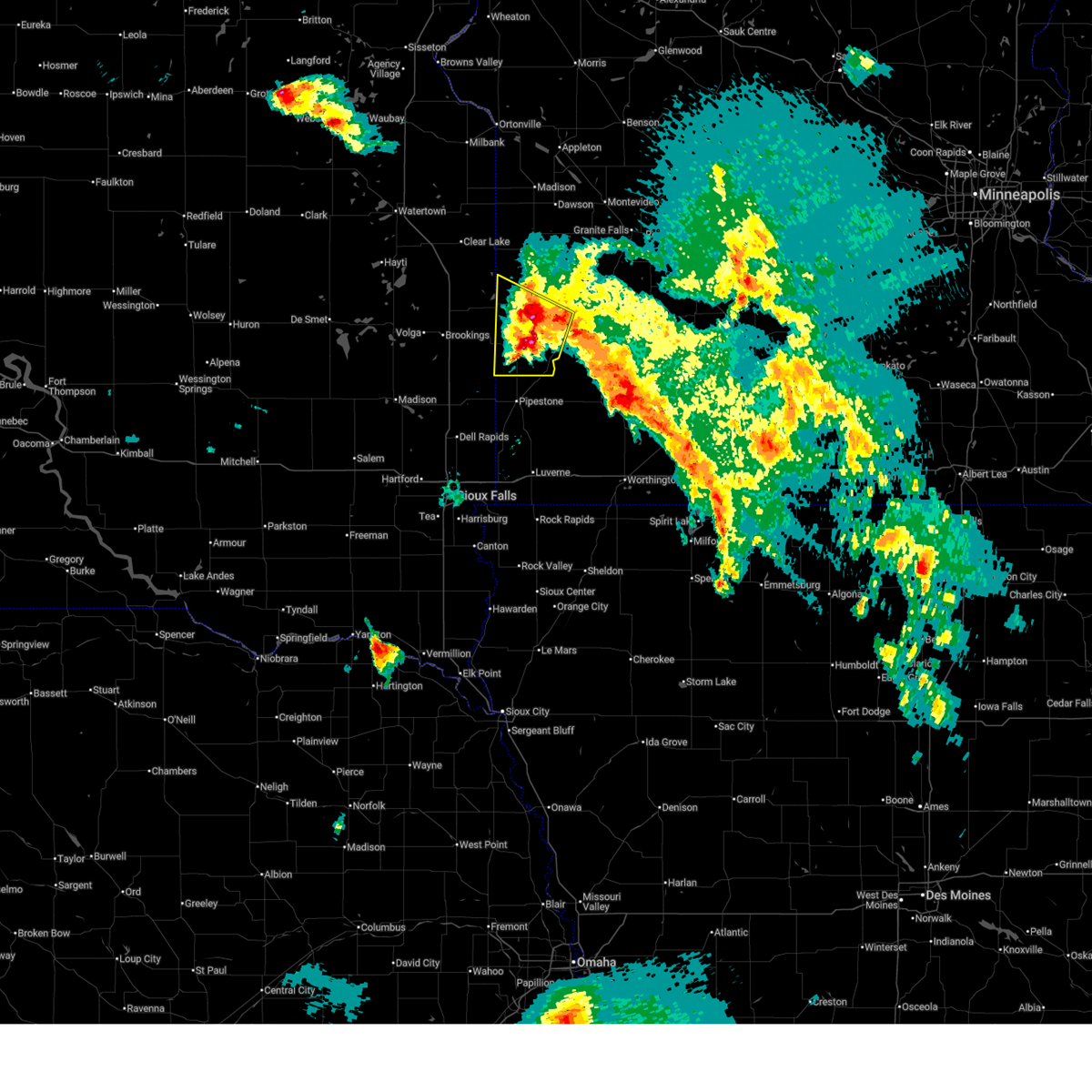
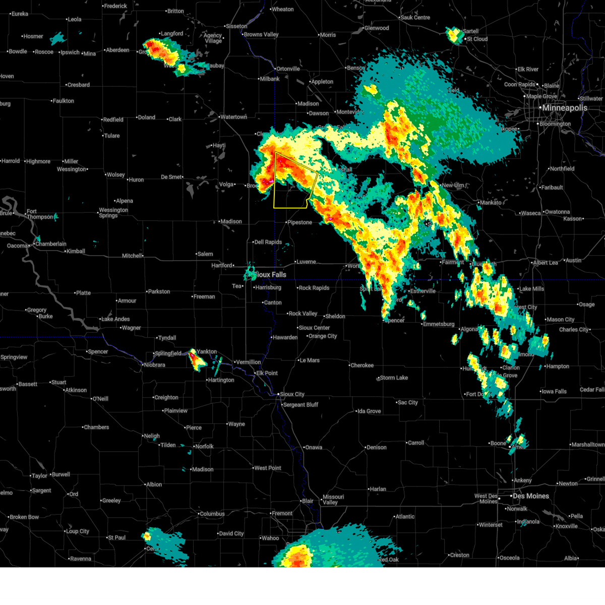
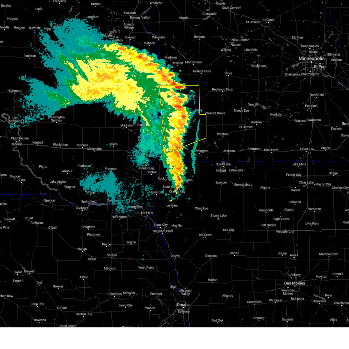
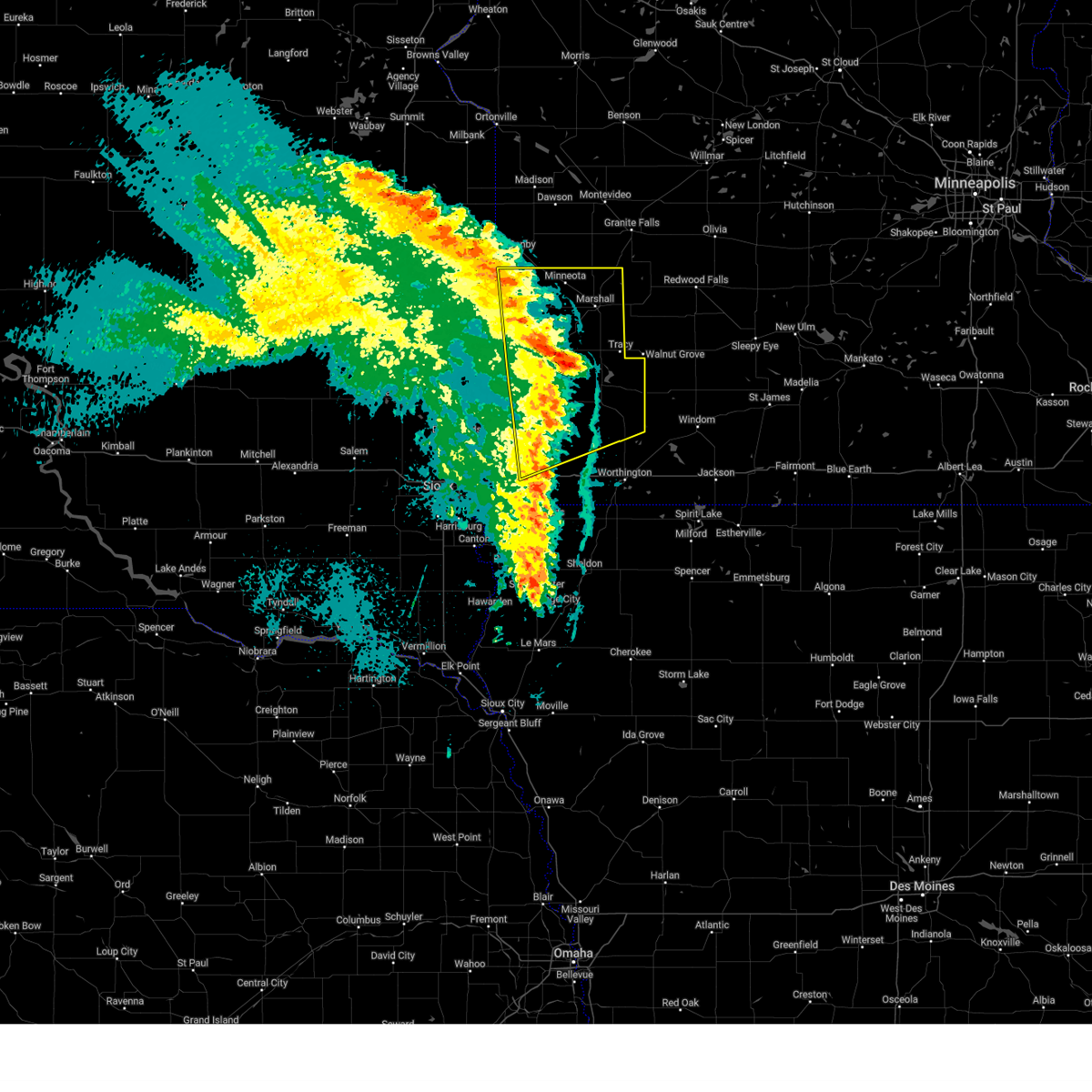
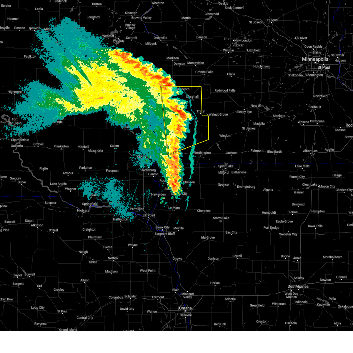
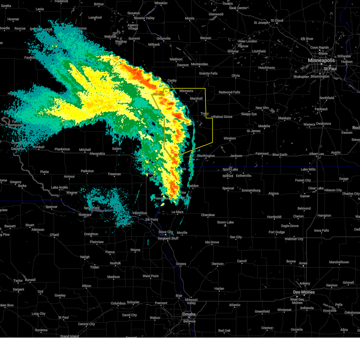
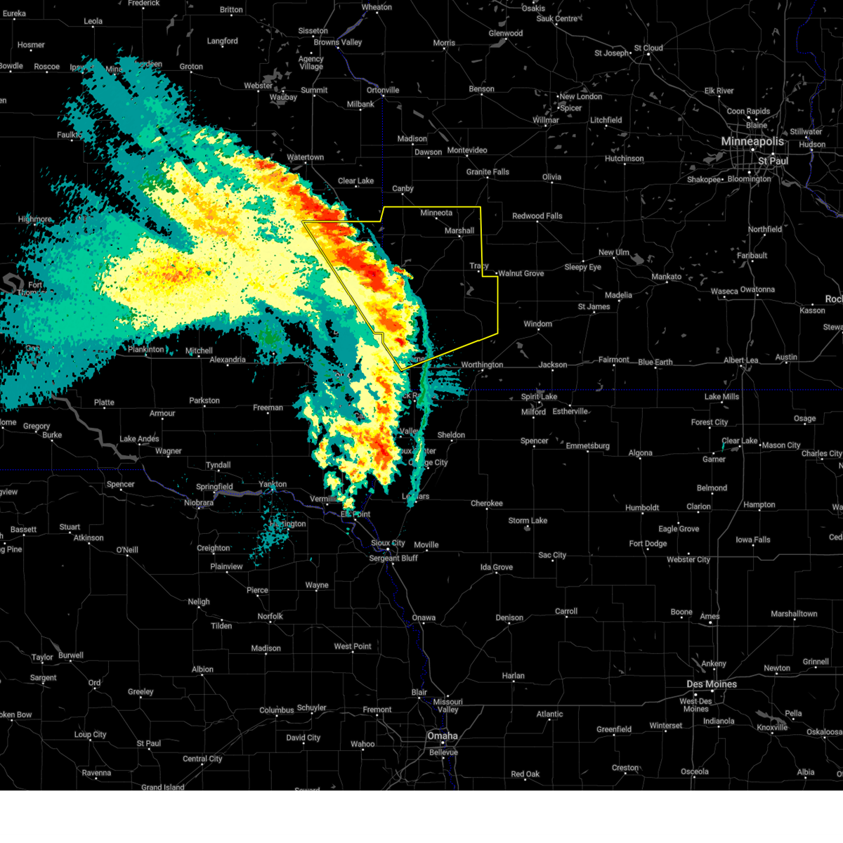
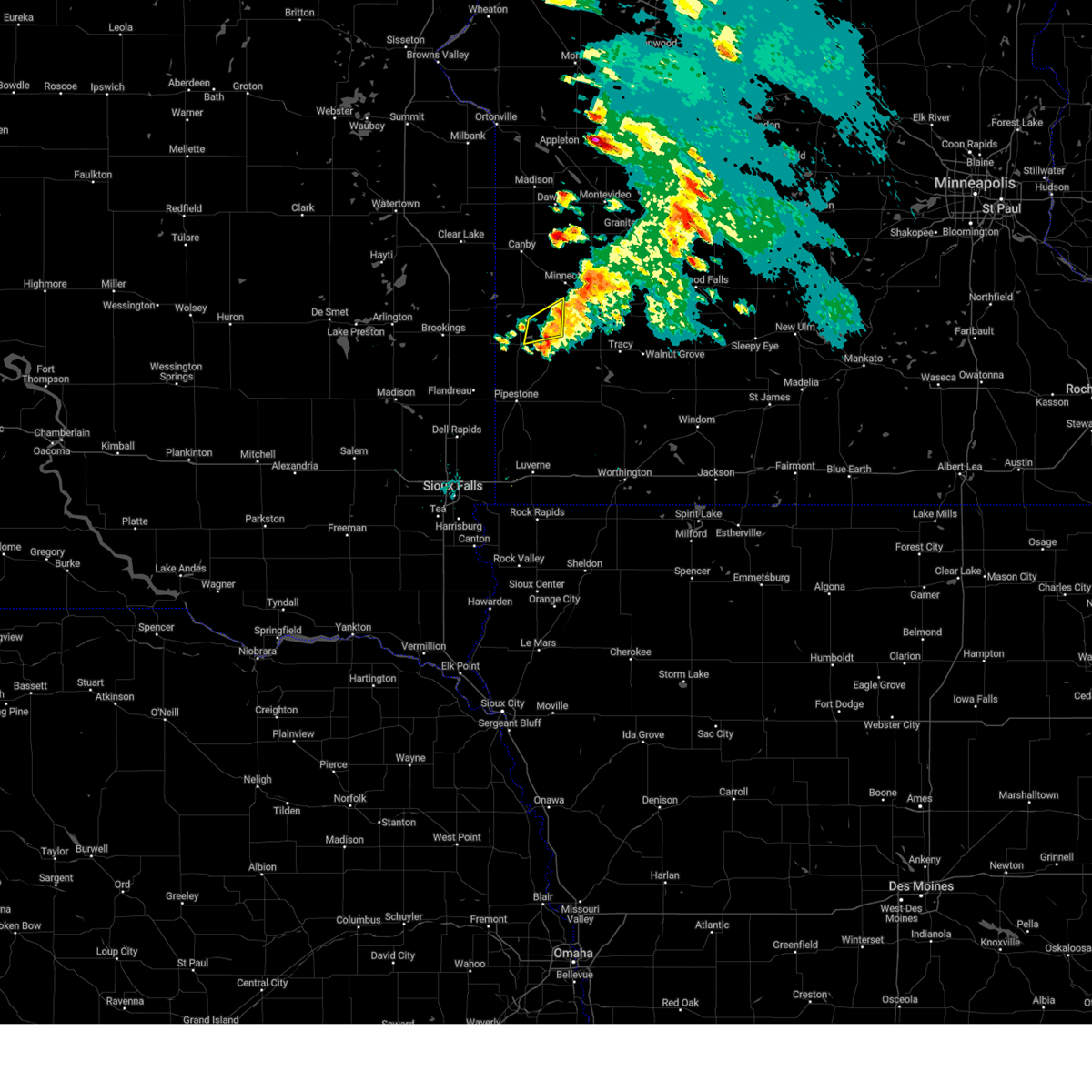
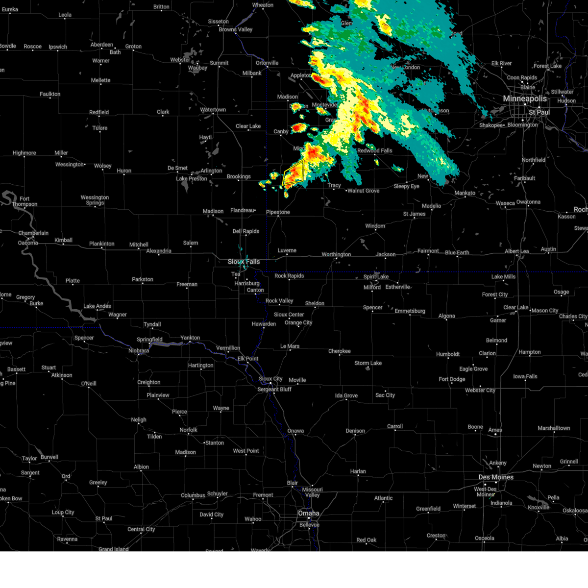
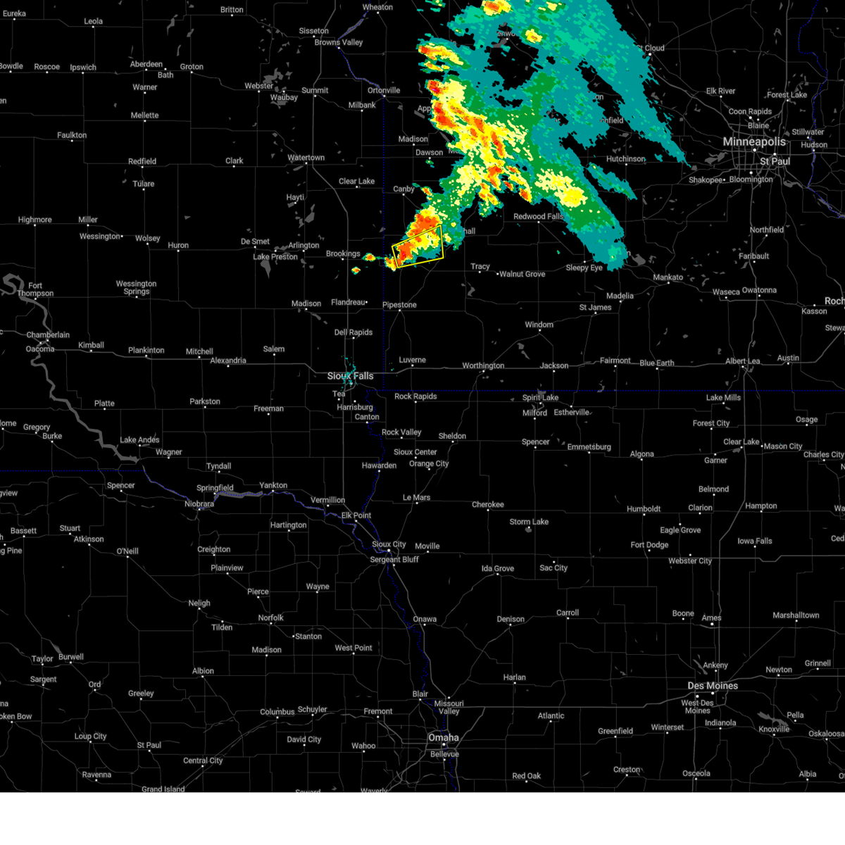
Hail Map for Tyler, MN
The Tyler, MN area has had 5 reports of on-the-ground hail by trained spotters, and has been under severe weather warnings 20 times during the past 12 months. Doppler radar has detected hail at or near Tyler, MN on 45 occasions, including 4 occasions during the past year.
| Name: | Tyler, MN |
| Where Located: | 51.1 miles SSW of Montevideo, MN |
| Map: | Google Map for Tyler, MN |
| Population: | 1143 |
| Housing Units: | 583 |
| More Info: | Search Google for Tyler, MN |
2
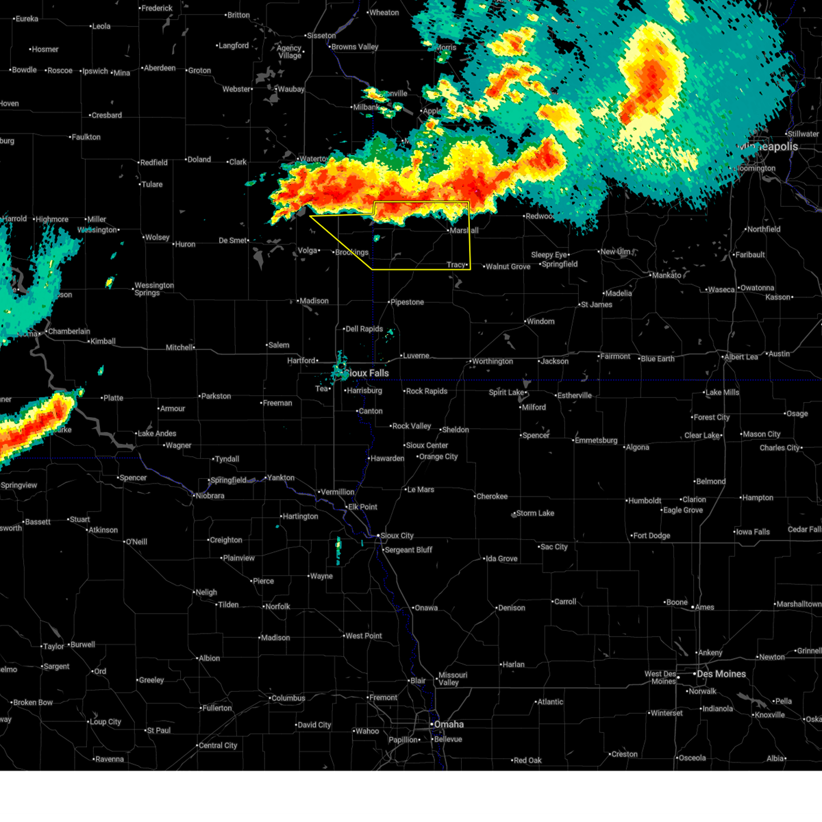
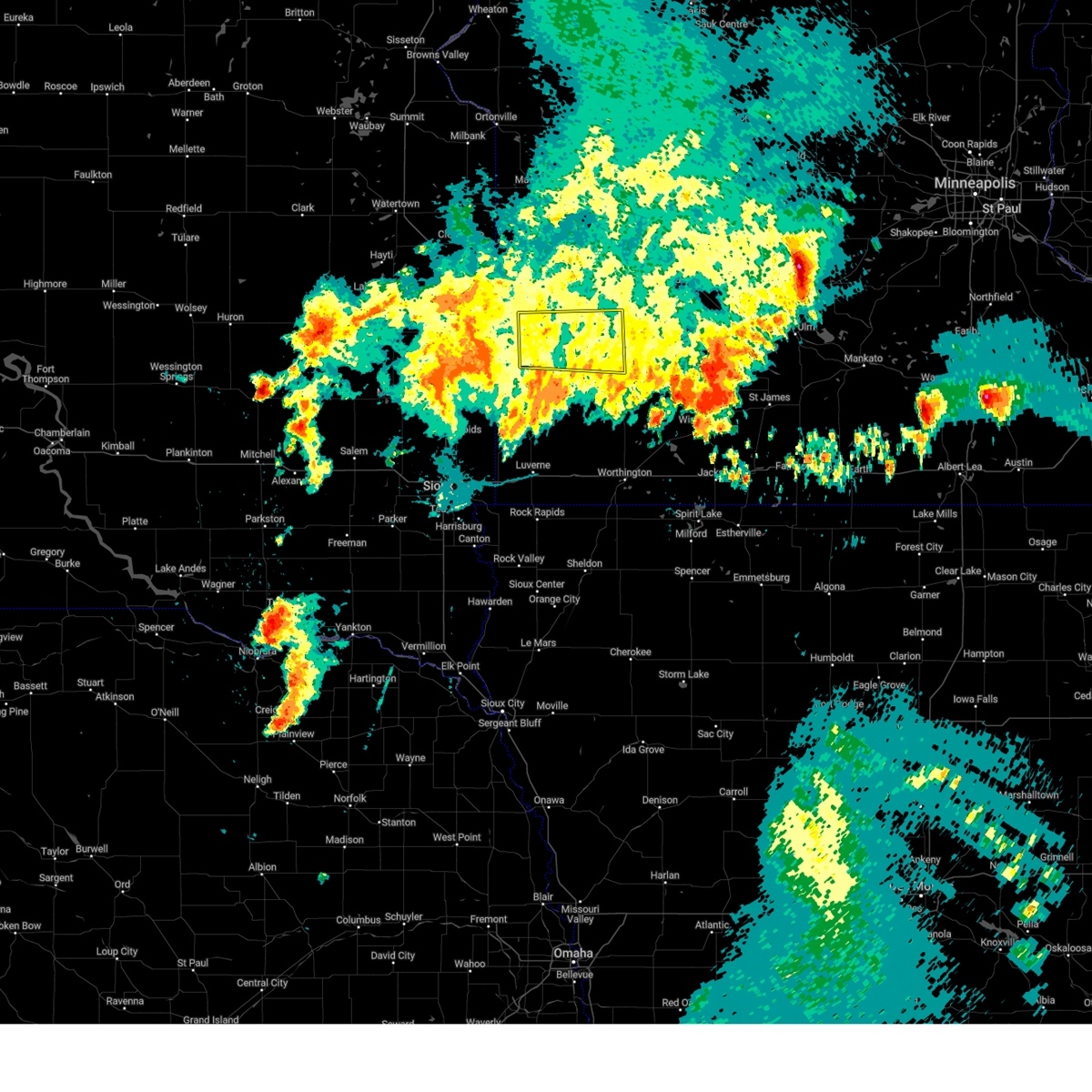
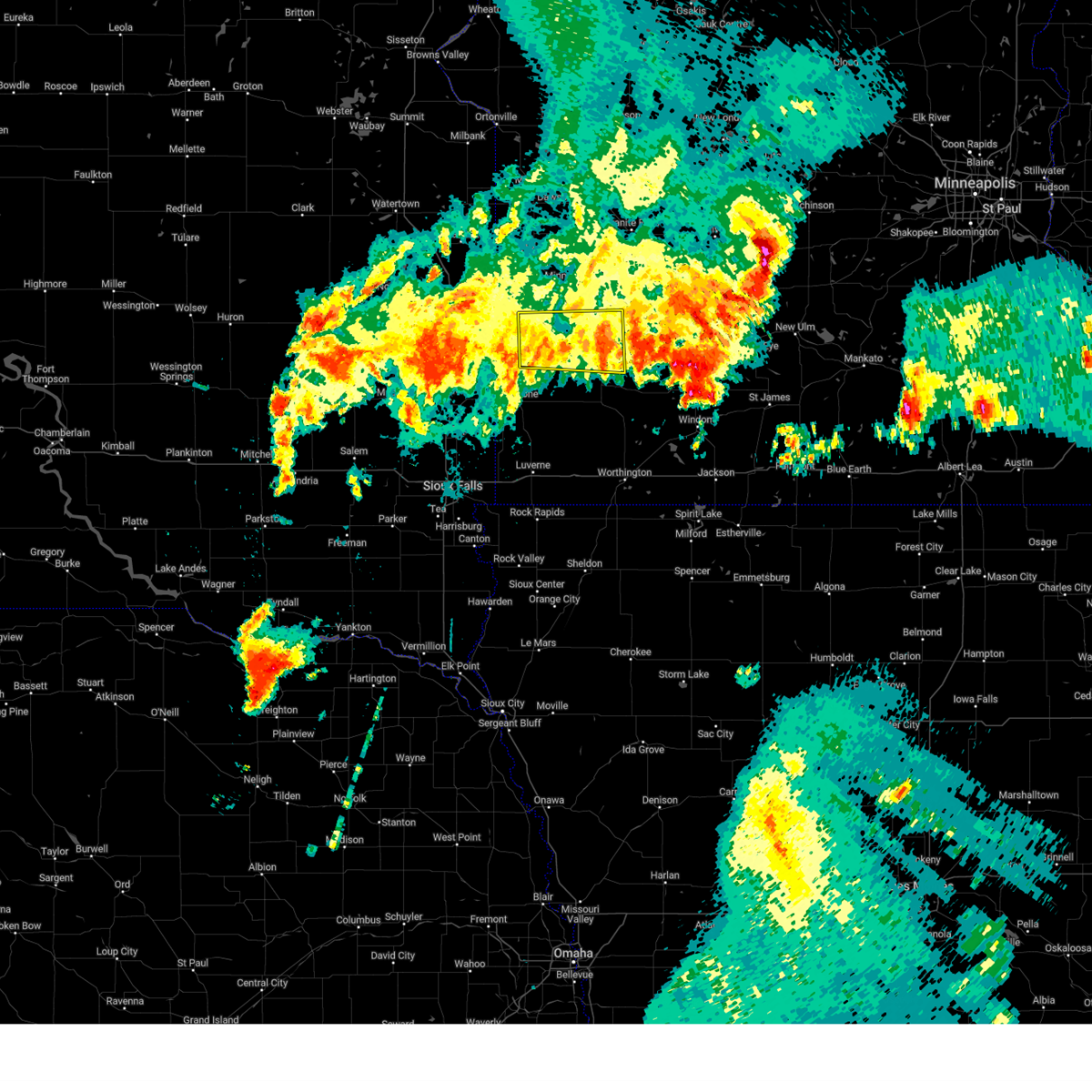
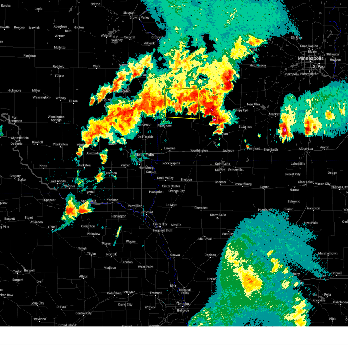
The Top Recent Hail Date for Tyler, MN is Thursday, June 19, 2025 (2nd out of 45)
Hail and Wind Damage Spotted near Tyler, MN
| Date / Time | Report Details |
|---|---|
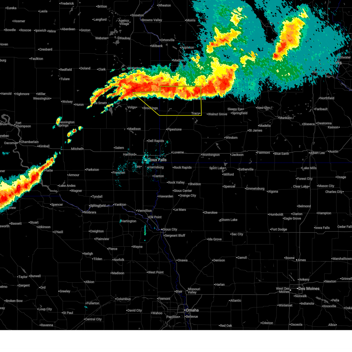
| 6/28/2025 11:12 PM CDT |
 This portion of the line of storms which prompted the warning have weakened below severe limits, and no longer pose an immediate threat to life or property. therefore, the warning will be allowed to expire. however, gusty winds and heavy rain are still possible with these thunderstorms. a tornado watch remains in effect until 100 am cdt for southwestern minnesota, and east central south dakota. remember, a severe thunderstorm warning still remains in effect for brookings and eastern kingsbury county until 1130 pm cdt. This portion of the line of storms which prompted the warning have weakened below severe limits, and no longer pose an immediate threat to life or property. therefore, the warning will be allowed to expire. however, gusty winds and heavy rain are still possible with these thunderstorms. a tornado watch remains in effect until 100 am cdt for southwestern minnesota, and east central south dakota. remember, a severe thunderstorm warning still remains in effect for brookings and eastern kingsbury county until 1130 pm cdt.
|
| 6/28/2025 10:57 PM CDT |
 At 1057 pm cdt, severe thunderstorms were located along a line extending from near wabasso to near russell to white, moving southeast at 30 mph (radar indicated). Hazards include 60 mph wind gusts and penny size hail. Expect damage to roofs, siding, and trees. Locations impacted include, tracy, tyler, lake benton, balaton, russell, florence, camden state park and elkton. At 1057 pm cdt, severe thunderstorms were located along a line extending from near wabasso to near russell to white, moving southeast at 30 mph (radar indicated). Hazards include 60 mph wind gusts and penny size hail. Expect damage to roofs, siding, and trees. Locations impacted include, tracy, tyler, lake benton, balaton, russell, florence, camden state park and elkton.
|
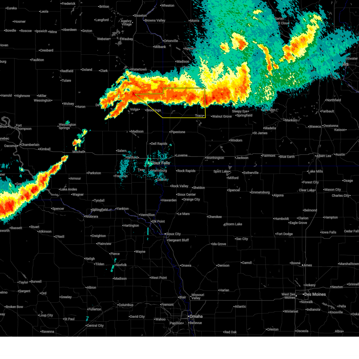
| 6/28/2025 10:33 PM CDT |
 Svrfsd the national weather service in sioux falls has issued a * severe thunderstorm warning for, lyon county in southwestern minnesota, lincoln county in southwestern minnesota, northeastern brookings county in east central south dakota, * until 1115 pm cdt. * at 1032 pm cdt, severe thunderstorms were located along a line extending from near echo to near ivanhoe to near toronto, moving southeast at 35 mph (automated weather station. at 1015 pm cdt, a 62 mph wind gust was reported by just southeast of taunton). Hazards include 60 mph wind gusts and nickel size hail. Expect damage to roofs, siding, and trees. severe thunderstorms will be near, marshall, hendricks, ivanhoe, white, ghent, and arco around 1040 pm cdt. camden state park around 1045 pm cdt. Other locations in the path of these severe thunderstorms include russell. Svrfsd the national weather service in sioux falls has issued a * severe thunderstorm warning for, lyon county in southwestern minnesota, lincoln county in southwestern minnesota, northeastern brookings county in east central south dakota, * until 1115 pm cdt. * at 1032 pm cdt, severe thunderstorms were located along a line extending from near echo to near ivanhoe to near toronto, moving southeast at 35 mph (automated weather station. at 1015 pm cdt, a 62 mph wind gust was reported by just southeast of taunton). Hazards include 60 mph wind gusts and nickel size hail. Expect damage to roofs, siding, and trees. severe thunderstorms will be near, marshall, hendricks, ivanhoe, white, ghent, and arco around 1040 pm cdt. camden state park around 1045 pm cdt. Other locations in the path of these severe thunderstorms include russell.
|
| 6/20/2025 1:11 AM CDT |
 The storm which prompted the warning has moved out of the area. therefore, the warning will be allowed to expire. a severe thunderstorm watch remains in effect until 400 am cdt for southwestern minnesota. The storm which prompted the warning has moved out of the area. therefore, the warning will be allowed to expire. a severe thunderstorm watch remains in effect until 400 am cdt for southwestern minnesota.
|
| 6/20/2025 1:04 AM CDT |
 At 104 am cdt, a severe thunderstorm was located over tyler, or 18 miles southwest of marshall, moving southeast at 45 mph (public). Hazards include 60 mph wind gusts and quarter size hail. Hail damage to vehicles is expected. expect wind damage to roofs, siding, and trees. Locations impacted include, tyler, lake benton, ruthton, arco, and florence. At 104 am cdt, a severe thunderstorm was located over tyler, or 18 miles southwest of marshall, moving southeast at 45 mph (public). Hazards include 60 mph wind gusts and quarter size hail. Hail damage to vehicles is expected. expect wind damage to roofs, siding, and trees. Locations impacted include, tyler, lake benton, ruthton, arco, and florence.
|
| 6/20/2025 12:57 AM CDT |
 At 1256 am cdt, a severe thunderstorm was located over arco, or 22 miles west of marshall, moving southeast at 45 mph (at 12:55 am cdt a public report of hail the size of quarters was reported 3 southwest of arco). Hazards include 60 mph wind gusts and quarter size hail. Hail damage to vehicles is expected. expect wind damage to roofs, siding, and trees. Locations impacted include, tyler, arco, florence and ruthton. At 1256 am cdt, a severe thunderstorm was located over arco, or 22 miles west of marshall, moving southeast at 45 mph (at 12:55 am cdt a public report of hail the size of quarters was reported 3 southwest of arco). Hazards include 60 mph wind gusts and quarter size hail. Hail damage to vehicles is expected. expect wind damage to roofs, siding, and trees. Locations impacted include, tyler, arco, florence and ruthton.
|
| 6/20/2025 12:36 AM CDT |
 Svrfsd the national weather service in sioux falls has issued a * severe thunderstorm warning for, southwestern lyon county in southwestern minnesota, lincoln county in southwestern minnesota, northern pipestone county in southwestern minnesota, * until 115 am cdt. * at 1235 am cdt, a severe thunderstorm was located near hendricks, or 18 miles northeast of brookings, moving southeast at 45 mph (at 12:15 am cdt, the mesonet 2 miles north of brookings reported 60 mph wind gusts). Hazards include 60 mph wind gusts and quarter size hail. Hail damage to vehicles is expected. expect wind damage to roofs, siding, and trees. this severe thunderstorm will be near, ivanhoe around 1240 am cdt. arco around 1245 am cdt. tyler and lake benton around 1250 am cdt. Other locations in the path of this severe thunderstorm include florence and ruthton. Svrfsd the national weather service in sioux falls has issued a * severe thunderstorm warning for, southwestern lyon county in southwestern minnesota, lincoln county in southwestern minnesota, northern pipestone county in southwestern minnesota, * until 115 am cdt. * at 1235 am cdt, a severe thunderstorm was located near hendricks, or 18 miles northeast of brookings, moving southeast at 45 mph (at 12:15 am cdt, the mesonet 2 miles north of brookings reported 60 mph wind gusts). Hazards include 60 mph wind gusts and quarter size hail. Hail damage to vehicles is expected. expect wind damage to roofs, siding, and trees. this severe thunderstorm will be near, ivanhoe around 1240 am cdt. arco around 1245 am cdt. tyler and lake benton around 1250 am cdt. Other locations in the path of this severe thunderstorm include florence and ruthton.
|
| 5/15/2025 4:10 AM CDT |
 The storms which prompted the warning have weakened below severe limits, and no longer pose an immediate threat to life or property. therefore, the warning will be allowed to expire. however, gusty winds and heavy rain are still possible with these thunderstorms. a severe thunderstorm watch remains in effect until 900 am cdt for southwestern minnesota. to report severe weather, contact your nearest law enforcement agency. they will relay your report to the national weather service sioux falls. The storms which prompted the warning have weakened below severe limits, and no longer pose an immediate threat to life or property. therefore, the warning will be allowed to expire. however, gusty winds and heavy rain are still possible with these thunderstorms. a severe thunderstorm watch remains in effect until 900 am cdt for southwestern minnesota. to report severe weather, contact your nearest law enforcement agency. they will relay your report to the national weather service sioux falls.
|
| 5/15/2025 3:52 AM CDT |
 the severe thunderstorm warning has been cancelled and is no longer in effect the severe thunderstorm warning has been cancelled and is no longer in effect
|
| 5/15/2025 3:52 AM CDT |
 At 352 am cdt, severe thunderstorms were located along a line extending from moritz to 6 miles northeast of ivanhoe to russell to near current lake, moving northeast at 40 mph (radar indicated). Hazards include 60 mph wind gusts. Expect damage to roofs, siding, and trees. these severe storms will be near, minneota, balaton, russell, taunton, and camden state park around 355 am cdt. marshall and ghent around 400 am cdt. tracy around 410 am cdt. cottonwood around 420 am cdt. Other locations impacted by these severe thunderstorms include kenneth, avoca, hadley, lynd, garvin, iona, hatfield, and dundee. At 352 am cdt, severe thunderstorms were located along a line extending from moritz to 6 miles northeast of ivanhoe to russell to near current lake, moving northeast at 40 mph (radar indicated). Hazards include 60 mph wind gusts. Expect damage to roofs, siding, and trees. these severe storms will be near, minneota, balaton, russell, taunton, and camden state park around 355 am cdt. marshall and ghent around 400 am cdt. tracy around 410 am cdt. cottonwood around 420 am cdt. Other locations impacted by these severe thunderstorms include kenneth, avoca, hadley, lynd, garvin, iona, hatfield, and dundee.
|
| 5/15/2025 3:42 AM CDT |
 At 341 am cdt, severe thunderstorms were located along a line extending from near clear lake to ivanhoe to florence to near lake wilson, moving northeast at 40 mph (radar indicated). Hazards include 60 mph wind gusts. Expect damage to roofs, siding, and trees. these severe storms will be near, balaton, russell, camden state park, and current lake around 345 am cdt. taunton around 350 am cdt. minneota around 355 am cdt. marshall and ghent around 400 am cdt. tracy around 410 am cdt. cottonwood around 420 am cdt. Other locations impacted by these severe thunderstorms include kenneth, ihlen, avoca, hadley, lynd, garvin, iona, hatfield, and dundee. At 341 am cdt, severe thunderstorms were located along a line extending from near clear lake to ivanhoe to florence to near lake wilson, moving northeast at 40 mph (radar indicated). Hazards include 60 mph wind gusts. Expect damage to roofs, siding, and trees. these severe storms will be near, balaton, russell, camden state park, and current lake around 345 am cdt. taunton around 350 am cdt. minneota around 355 am cdt. marshall and ghent around 400 am cdt. tracy around 410 am cdt. cottonwood around 420 am cdt. Other locations impacted by these severe thunderstorms include kenneth, ihlen, avoca, hadley, lynd, garvin, iona, hatfield, and dundee.
|
| 5/15/2025 3:42 AM CDT |
 the severe thunderstorm warning has been cancelled and is no longer in effect the severe thunderstorm warning has been cancelled and is no longer in effect
|
| 5/15/2025 3:17 AM CDT |
 At 316 am cdt, severe thunderstorms were located along a line extending from near estelline to near elkton to near holland to edgerton, moving northeast at 40 mph (trained weather spotters. at 306 am cdt, a 60 mph wind gust was reported 2 miles north of trosky). Hazards include 60 mph wind gusts and quarter size hail. Hail damage to vehicles is expected. expect wind damage to roofs, siding, and trees. these severe storms will be near, edgerton, lake benton, ruthton, holland, and woodstock around 320 am cdt. tyler and hendricks around 325 am cdt. ivanhoe, chandler, lake wilson, arco, and florence around 330 am cdt. current lake around 335 am cdt. russell around 340 am cdt. balaton and camden state park around 345 am cdt. taunton around 350 am cdt. marshall, minneota, and ghent around 355 am cdt. Other locations impacted by these severe thunderstorms include kenneth, ihlen, avoca, flandreau santee sioux tribal nation, hadley, lynd, garvin, iona, hatfield, and bushnell. At 316 am cdt, severe thunderstorms were located along a line extending from near estelline to near elkton to near holland to edgerton, moving northeast at 40 mph (trained weather spotters. at 306 am cdt, a 60 mph wind gust was reported 2 miles north of trosky). Hazards include 60 mph wind gusts and quarter size hail. Hail damage to vehicles is expected. expect wind damage to roofs, siding, and trees. these severe storms will be near, edgerton, lake benton, ruthton, holland, and woodstock around 320 am cdt. tyler and hendricks around 325 am cdt. ivanhoe, chandler, lake wilson, arco, and florence around 330 am cdt. current lake around 335 am cdt. russell around 340 am cdt. balaton and camden state park around 345 am cdt. taunton around 350 am cdt. marshall, minneota, and ghent around 355 am cdt. Other locations impacted by these severe thunderstorms include kenneth, ihlen, avoca, flandreau santee sioux tribal nation, hadley, lynd, garvin, iona, hatfield, and bushnell.
|
| 5/15/2025 3:06 AM CDT |
 Svrfsd the national weather service in sioux falls has issued a * severe thunderstorm warning for, lyon county in southwestern minnesota, northern rock county in southwestern minnesota, lincoln county in southwestern minnesota, northwestern nobles county in southwestern minnesota, pipestone county in southwestern minnesota, murray county in southwestern minnesota, eastern moody county in east central south dakota, brookings county in east central south dakota, * until 415 am cdt. * at 306 am cdt, severe thunderstorms were located along a line extending from near estelline to elkton to near pipestone national monument to near hardwick, moving northeast at 35 mph (radar indicated). Hazards include 60 mph wind gusts and quarter size hail. Hail damage to vehicles is expected. expect wind damage to roofs, siding, and trees. severe thunderstorms will be near, pipestone, edgerton, elkton, lake benton, white, holland, and trosky around 310 am cdt. woodstock around 315 am cdt. hendricks and ruthton around 320 am cdt. tyler, chandler, lake wilson, arco, and florence around 325 am cdt. Other locations in the path of these severe thunderstorms include ivanhoe, current lake, balaton, russell, camden state park, minneota and taunton. Svrfsd the national weather service in sioux falls has issued a * severe thunderstorm warning for, lyon county in southwestern minnesota, northern rock county in southwestern minnesota, lincoln county in southwestern minnesota, northwestern nobles county in southwestern minnesota, pipestone county in southwestern minnesota, murray county in southwestern minnesota, eastern moody county in east central south dakota, brookings county in east central south dakota, * until 415 am cdt. * at 306 am cdt, severe thunderstorms were located along a line extending from near estelline to elkton to near pipestone national monument to near hardwick, moving northeast at 35 mph (radar indicated). Hazards include 60 mph wind gusts and quarter size hail. Hail damage to vehicles is expected. expect wind damage to roofs, siding, and trees. severe thunderstorms will be near, pipestone, edgerton, elkton, lake benton, white, holland, and trosky around 310 am cdt. woodstock around 315 am cdt. hendricks and ruthton around 320 am cdt. tyler, chandler, lake wilson, arco, and florence around 325 am cdt. Other locations in the path of these severe thunderstorms include ivanhoe, current lake, balaton, russell, camden state park, minneota and taunton.
|
| 8/22/2024 11:24 AM CDT |
 The storm which prompted the warning has weakened below severe limits, and no longer poses an immediate threat to life or property. therefore, the warning will be allowed to expire. however, small hail is still possible with this thunderstorm. The storm which prompted the warning has weakened below severe limits, and no longer poses an immediate threat to life or property. therefore, the warning will be allowed to expire. however, small hail is still possible with this thunderstorm.
|
| 8/22/2024 11:11 AM CDT |
 At 1109 am cdt, a severe thunderstorm was located over arco, or 17 miles west of marshall, moving east at 20 mph. another storm was developing between lake benton and tyler, moving east at 20 mph (radar indicated). Hazards include quarter size hail. Damage to vehicles is expected. This severe thunderstorm will remain over mainly rural areas of west central lyon and southeastern lincoln counties. At 1109 am cdt, a severe thunderstorm was located over arco, or 17 miles west of marshall, moving east at 20 mph. another storm was developing between lake benton and tyler, moving east at 20 mph (radar indicated). Hazards include quarter size hail. Damage to vehicles is expected. This severe thunderstorm will remain over mainly rural areas of west central lyon and southeastern lincoln counties.
|
| 8/22/2024 10:53 AM CDT |
 Svrfsd the national weather service in sioux falls has issued a * severe thunderstorm warning for, west central lyon county in southwestern minnesota, southern lincoln county in southwestern minnesota, * until 1130 am cdt. * at 1052 am cdt, a severe thunderstorm was located near arco, or 23 miles west of marshall, moving east at 20 mph (radar indicated). Hazards include quarter size hail. Damage to vehicles is expected. This severe thunderstorm will be near, tyler and arco around 1100 am cdt. Svrfsd the national weather service in sioux falls has issued a * severe thunderstorm warning for, west central lyon county in southwestern minnesota, southern lincoln county in southwestern minnesota, * until 1130 am cdt. * at 1052 am cdt, a severe thunderstorm was located near arco, or 23 miles west of marshall, moving east at 20 mph (radar indicated). Hazards include quarter size hail. Damage to vehicles is expected. This severe thunderstorm will be near, tyler and arco around 1100 am cdt.
|
| 7/31/2024 9:20 PM CDT |
 The storms which prompted the warning have weakened below severe limits, and no longer pose an immediate threat to life or property. therefore, the warning has been allowed to expire. however, heavy rain is still possible with these thunderstorms. a severe thunderstorm watch remains in effect until midnight cdt for southwestern minnesota. to report severe weather, contact your nearest law enforcement agency. they will relay your report to the national weather service sioux falls. The storms which prompted the warning have weakened below severe limits, and no longer pose an immediate threat to life or property. therefore, the warning has been allowed to expire. however, heavy rain is still possible with these thunderstorms. a severe thunderstorm watch remains in effect until midnight cdt for southwestern minnesota. to report severe weather, contact your nearest law enforcement agency. they will relay your report to the national weather service sioux falls.
|
| 7/31/2024 9:00 PM CDT |
 At 900 pm cdt, severe thunderstorms were located along a line extending from near tracy to near balaton to near ruthton, moving east at 25 mph (radar indicated). Hazards include 60 mph wind gusts. Expect damage to roofs, siding, and trees. Locations impacted include, tracy, balaton, ruthton and florence. At 900 pm cdt, severe thunderstorms were located along a line extending from near tracy to near balaton to near ruthton, moving east at 25 mph (radar indicated). Hazards include 60 mph wind gusts. Expect damage to roofs, siding, and trees. Locations impacted include, tracy, balaton, ruthton and florence.
|
| 7/31/2024 8:30 PM CDT |
 Svrfsd the national weather service in sioux falls has issued a * severe thunderstorm warning for, lyon county in southwestern minnesota, eastern lincoln county in southwestern minnesota, northeastern pipestone county in southwestern minnesota, northwestern murray county in southwestern minnesota, * until 915 pm cdt. * at 830 pm cdt, severe thunderstorms were located along a line extending from near russell to florence to lake benton, moving southeast at 30 mph (radar indicated). Hazards include 60 mph wind gusts. Expect damage to roofs, siding, and trees. Severe thunderstorms will be near, lake benton, balaton, ruthton, and florence around 835 pm cdt. Svrfsd the national weather service in sioux falls has issued a * severe thunderstorm warning for, lyon county in southwestern minnesota, eastern lincoln county in southwestern minnesota, northeastern pipestone county in southwestern minnesota, northwestern murray county in southwestern minnesota, * until 915 pm cdt. * at 830 pm cdt, severe thunderstorms were located along a line extending from near russell to florence to lake benton, moving southeast at 30 mph (radar indicated). Hazards include 60 mph wind gusts. Expect damage to roofs, siding, and trees. Severe thunderstorms will be near, lake benton, balaton, ruthton, and florence around 835 pm cdt.
|
| 5/6/2024 9:15 PM CDT |
 the tornado warning has been cancelled and is no longer in effect the tornado warning has been cancelled and is no longer in effect
|
| 5/6/2024 8:57 PM CDT |
 At 857 pm cdt, a severe thunderstorm capable of producing a tornado was located near lake benton, or 17 miles north of pipestone, moving north at 55 mph (radar indicated rotation). Hazards include tornado. Flying debris will be dangerous to those caught without shelter. mobile homes will be damaged or destroyed. damage to roofs, windows, and vehicles will occur. tree damage is likely. this dangerous storm will be near, lake benton around 900 pm cdt. Other locations in the path of this tornadic thunderstorm include arco. At 857 pm cdt, a severe thunderstorm capable of producing a tornado was located near lake benton, or 17 miles north of pipestone, moving north at 55 mph (radar indicated rotation). Hazards include tornado. Flying debris will be dangerous to those caught without shelter. mobile homes will be damaged or destroyed. damage to roofs, windows, and vehicles will occur. tree damage is likely. this dangerous storm will be near, lake benton around 900 pm cdt. Other locations in the path of this tornadic thunderstorm include arco.
|
| 5/6/2024 8:57 PM CDT |
 Torfsd the national weather service in sioux falls has issued a * tornado warning for, southwestern lyon county in southwestern minnesota, southeastern lincoln county in southwestern minnesota, northwestern murray county in southwestern minnesota, northeastern pipestone county in southwestern minnesota, * until 930 pm cdt. * at 857 pm cdt, a severe thunderstorm capable of producing a tornado was located over holland, or near pipestone, moving northeast at 45 mph (radar indicated rotation). Hazards include tornado. Flying debris will be dangerous to those caught without shelter. mobile homes will be damaged or destroyed. damage to roofs, windows, and vehicles will occur. tree damage is likely. this dangerous storm will be near, ruthton and holland around 900 pm cdt. florence around 905 pm cdt. Tyler around 910 pm cdt. Torfsd the national weather service in sioux falls has issued a * tornado warning for, southwestern lyon county in southwestern minnesota, southeastern lincoln county in southwestern minnesota, northwestern murray county in southwestern minnesota, northeastern pipestone county in southwestern minnesota, * until 930 pm cdt. * at 857 pm cdt, a severe thunderstorm capable of producing a tornado was located over holland, or near pipestone, moving northeast at 45 mph (radar indicated rotation). Hazards include tornado. Flying debris will be dangerous to those caught without shelter. mobile homes will be damaged or destroyed. damage to roofs, windows, and vehicles will occur. tree damage is likely. this dangerous storm will be near, ruthton and holland around 900 pm cdt. florence around 905 pm cdt. Tyler around 910 pm cdt.
|
| 5/6/2024 8:57 PM CDT |
 the tornado warning has been cancelled and is no longer in effect the tornado warning has been cancelled and is no longer in effect
|
| 5/6/2024 8:42 PM CDT |
 Torfsd the national weather service in sioux falls has issued a * tornado warning for, southern lincoln county in southwestern minnesota, northwestern pipestone county in southwestern minnesota, northeastern moody county in east central south dakota, southeastern brookings county in east central south dakota, * until 915 pm cdt. * at 842 pm cdt, a severe thunderstorm capable of producing a tornado was located near pipestone national monument, or 7 miles northwest of pipestone, moving north at 55 mph (radar indicated rotation). Hazards include tornado. Flying debris will be dangerous to those caught without shelter. mobile homes will be damaged or destroyed. damage to roofs, windows, and vehicles will occur. tree damage is likely. this dangerous storm will be near, elkton, lake benton, and ward around 850 pm cdt. Other locations in the path of this tornadic thunderstorm include tyler and arco. Torfsd the national weather service in sioux falls has issued a * tornado warning for, southern lincoln county in southwestern minnesota, northwestern pipestone county in southwestern minnesota, northeastern moody county in east central south dakota, southeastern brookings county in east central south dakota, * until 915 pm cdt. * at 842 pm cdt, a severe thunderstorm capable of producing a tornado was located near pipestone national monument, or 7 miles northwest of pipestone, moving north at 55 mph (radar indicated rotation). Hazards include tornado. Flying debris will be dangerous to those caught without shelter. mobile homes will be damaged or destroyed. damage to roofs, windows, and vehicles will occur. tree damage is likely. this dangerous storm will be near, elkton, lake benton, and ward around 850 pm cdt. Other locations in the path of this tornadic thunderstorm include tyler and arco.
|
| 8/11/2023 4:26 PM CDT |
 At 425 pm cdt, a severe thunderstorm was located near balaton, or 17 miles northwest of slayton, moving southeast at 35 mph (at 4:19 cdt trained spotters reported quarter sized hail east of florence). Hazards include 60 mph wind gusts and quarter size hail. Hail damage to vehicles is expected. expect wind damage to roofs, siding, and trees. this severe storm will be near, balaton around 430 pm cdt. lake shetek state park around 435 pm cdt. other locations in the path of this severe thunderstorm include tracy and currie. hail threat, radar indicated max hail size, 1. 00 in wind threat, radar indicated max wind gust, 60 mph. At 425 pm cdt, a severe thunderstorm was located near balaton, or 17 miles northwest of slayton, moving southeast at 35 mph (at 4:19 cdt trained spotters reported quarter sized hail east of florence). Hazards include 60 mph wind gusts and quarter size hail. Hail damage to vehicles is expected. expect wind damage to roofs, siding, and trees. this severe storm will be near, balaton around 430 pm cdt. lake shetek state park around 435 pm cdt. other locations in the path of this severe thunderstorm include tracy and currie. hail threat, radar indicated max hail size, 1. 00 in wind threat, radar indicated max wind gust, 60 mph.
|
| 8/11/2023 4:16 PM CDT |
 At 416 pm cdt, a severe thunderstorm was located over florence, or 18 miles southwest of marshall, moving southeast at 35 mph (radar indicated). Hazards include 60 mph wind gusts and quarter size hail. Hail damage to vehicles is expected. expect wind damage to roofs, siding, and trees. this severe thunderstorm will be near, balaton, russell, and current lake around 420 pm cdt. lake shetek state park around 435 pm cdt. other locations in the path of this severe thunderstorm include tracy and currie. hail threat, radar indicated max hail size, 1. 00 in wind threat, radar indicated max wind gust, 60 mph. At 416 pm cdt, a severe thunderstorm was located over florence, or 18 miles southwest of marshall, moving southeast at 35 mph (radar indicated). Hazards include 60 mph wind gusts and quarter size hail. Hail damage to vehicles is expected. expect wind damage to roofs, siding, and trees. this severe thunderstorm will be near, balaton, russell, and current lake around 420 pm cdt. lake shetek state park around 435 pm cdt. other locations in the path of this severe thunderstorm include tracy and currie. hail threat, radar indicated max hail size, 1. 00 in wind threat, radar indicated max wind gust, 60 mph.
|
| 7/22/2023 4:27 PM CDT |
 The severe thunderstorm warning for west central lyon and southeastern lincoln counties will expire at 430 pm cdt, the storm which prompted the warning has weakened below severe limits, and has exited the warned area. therefore, the warning will be allowed to expire. The severe thunderstorm warning for west central lyon and southeastern lincoln counties will expire at 430 pm cdt, the storm which prompted the warning has weakened below severe limits, and has exited the warned area. therefore, the warning will be allowed to expire.
|
| 7/22/2023 4:13 PM CDT |
 At 413 pm cdt, a severe thunderstorm was located near ruthton, or 17 miles northwest of slayton, moving south at 25 mph (radar indicated). Hazards include 60 mph wind gusts and quarter size hail. Hail damage to vehicles is expected. expect wind damage to roofs, siding, and trees. this severe thunderstorm will remain over mainly rural areas of southwestern lyon, southeastern lincoln, northeastern pipestone and northwestern murray counties, including the following locations, garvin. hail threat, radar indicated max hail size, 1. 00 in wind threat, radar indicated max wind gust, 60 mph. At 413 pm cdt, a severe thunderstorm was located near ruthton, or 17 miles northwest of slayton, moving south at 25 mph (radar indicated). Hazards include 60 mph wind gusts and quarter size hail. Hail damage to vehicles is expected. expect wind damage to roofs, siding, and trees. this severe thunderstorm will remain over mainly rural areas of southwestern lyon, southeastern lincoln, northeastern pipestone and northwestern murray counties, including the following locations, garvin. hail threat, radar indicated max hail size, 1. 00 in wind threat, radar indicated max wind gust, 60 mph.
|
| 7/22/2023 4:07 PM CDT |
 At 407 pm cdt, a severe thunderstorm was located over arco, or 19 miles west of marshall, moving southeast at 25 mph (radar indicated). Hazards include 60 mph wind gusts and quarter size hail. Hail damage to vehicles is expected. expect wind damage to roofs, siding, and trees. locations impacted include, tyler. hail threat, radar indicated max hail size, 1. 00 in wind threat, radar indicated max wind gust, 60 mph. At 407 pm cdt, a severe thunderstorm was located over arco, or 19 miles west of marshall, moving southeast at 25 mph (radar indicated). Hazards include 60 mph wind gusts and quarter size hail. Hail damage to vehicles is expected. expect wind damage to roofs, siding, and trees. locations impacted include, tyler. hail threat, radar indicated max hail size, 1. 00 in wind threat, radar indicated max wind gust, 60 mph.
|
| 7/22/2023 3:57 PM CDT |
 The severe thunderstorm warning for southwestern lyon, southeastern lincoln, northeastern pipestone and northwestern murray counties will expire at 400 pm cdt, the storm which prompted the warning has moved out of the area. therefore, the warning will be allowed to expire. however small hail and gusty winds are still possible with this thunderstorm. remember, a severe thunderstorm warning still remains in effect for parts of lyon, lincoln, pipestone, and murray counties!. The severe thunderstorm warning for southwestern lyon, southeastern lincoln, northeastern pipestone and northwestern murray counties will expire at 400 pm cdt, the storm which prompted the warning has moved out of the area. therefore, the warning will be allowed to expire. however small hail and gusty winds are still possible with this thunderstorm. remember, a severe thunderstorm warning still remains in effect for parts of lyon, lincoln, pipestone, and murray counties!.
|
| 7/22/2023 3:55 PM CDT |
 At 355 pm cdt, a severe thunderstorm was located over florence, or 17 miles southwest of marshall, moving southeast at 20 mph (radar indicated). Hazards include 60 mph wind gusts and half dollar size hail. Hail damage to vehicles is expected. expect wind damage to roofs, siding, and trees. this severe thunderstorm will be near, balaton around 410 pm cdt. other locations in the path of this severe thunderstorm include current lake. hail threat, radar indicated max hail size, 1. 25 in wind threat, radar indicated max wind gust, 60 mph. At 355 pm cdt, a severe thunderstorm was located over florence, or 17 miles southwest of marshall, moving southeast at 20 mph (radar indicated). Hazards include 60 mph wind gusts and half dollar size hail. Hail damage to vehicles is expected. expect wind damage to roofs, siding, and trees. this severe thunderstorm will be near, balaton around 410 pm cdt. other locations in the path of this severe thunderstorm include current lake. hail threat, radar indicated max hail size, 1. 25 in wind threat, radar indicated max wind gust, 60 mph.
|
| 7/22/2023 3:51 PM CDT |
 At 350 pm cdt, a severe thunderstorm was located over ivanhoe, or 22 miles west of marshall, moving southeast at 15 mph (radar indicated). Hazards include 60 mph wind gusts and quarter size hail. Hail damage to vehicles is expected. expect wind damage to roofs, siding, and trees. this severe thunderstorm will be near, arco around 410 pm cdt. other locations in the path of this severe thunderstorm include lake benton and tyler. hail threat, radar indicated max hail size, 1. 00 in wind threat, radar indicated max wind gust, 60 mph. At 350 pm cdt, a severe thunderstorm was located over ivanhoe, or 22 miles west of marshall, moving southeast at 15 mph (radar indicated). Hazards include 60 mph wind gusts and quarter size hail. Hail damage to vehicles is expected. expect wind damage to roofs, siding, and trees. this severe thunderstorm will be near, arco around 410 pm cdt. other locations in the path of this severe thunderstorm include lake benton and tyler. hail threat, radar indicated max hail size, 1. 00 in wind threat, radar indicated max wind gust, 60 mph.
|
| 7/22/2023 3:37 PM CDT |
 At 336 pm cdt, a severe thunderstorm was located near arco, or 17 miles southwest of marshall, moving southeast at 15 mph (trained weather spotters. at 320 pm, quarter size hail was reported in arco, minnesota!). Hazards include 60 mph wind gusts and half dollar size hail. Hail damage to vehicles is expected. expect wind damage to roofs, siding, and trees. this severe storm will be near, tyler around 340 pm cdt. other locations in the path of this severe thunderstorm include russell, ruthton, florence, balaton and current lake. hail threat, observed max hail size, 1. 25 in wind threat, radar indicated max wind gust, 60 mph. At 336 pm cdt, a severe thunderstorm was located near arco, or 17 miles southwest of marshall, moving southeast at 15 mph (trained weather spotters. at 320 pm, quarter size hail was reported in arco, minnesota!). Hazards include 60 mph wind gusts and half dollar size hail. Hail damage to vehicles is expected. expect wind damage to roofs, siding, and trees. this severe storm will be near, tyler around 340 pm cdt. other locations in the path of this severe thunderstorm include russell, ruthton, florence, balaton and current lake. hail threat, observed max hail size, 1. 25 in wind threat, radar indicated max wind gust, 60 mph.
|
| 7/22/2023 3:20 PM CDT |
 At 319 pm cdt, a severe thunderstorm was located over arco, or 18 miles west of marshall, moving southeast at 25 mph (trained weather spotters. at 318 pm, trained weather spotters reported half dollar size hail in arco!). Hazards include 60 mph wind gusts and half dollar size hail. Hail damage to vehicles is expected. expect wind damage to roofs, siding, and trees. this severe thunderstorm will be near, tyler around 330 pm cdt. russell around 335 pm cdt. other locations in the path of this severe thunderstorm include florence, ruthton, balaton and current lake. hail threat, observed max hail size, 1. 25 in wind threat, radar indicated max wind gust, 60 mph. At 319 pm cdt, a severe thunderstorm was located over arco, or 18 miles west of marshall, moving southeast at 25 mph (trained weather spotters. at 318 pm, trained weather spotters reported half dollar size hail in arco!). Hazards include 60 mph wind gusts and half dollar size hail. Hail damage to vehicles is expected. expect wind damage to roofs, siding, and trees. this severe thunderstorm will be near, tyler around 330 pm cdt. russell around 335 pm cdt. other locations in the path of this severe thunderstorm include florence, ruthton, balaton and current lake. hail threat, observed max hail size, 1. 25 in wind threat, radar indicated max wind gust, 60 mph.
|
| 7/13/2023 6:16 PM CDT |
 At 615 pm cdt, a severe thunderstorm was located near lake benton, or 14 miles north of pipestone, moving southeast at 25 mph (public. at 612 pm, half dollar size hail was reported in lake benton, minnesota!). Hazards include golf ball size hail and 60 mph wind gusts. People and animals outdoors will be injured. expect hail damage to roofs, siding, windows, and vehicles. expect wind damage to roofs, siding, and trees. this severe storm will be near, tyler around 620 pm cdt. other locations in the path of this severe thunderstorm include ruthton, holland, florence and woodstock. thunderstorm damage threat, considerable hail threat, radar indicated max hail size, 1. 75 in wind threat, radar indicated max wind gust, 60 mph. At 615 pm cdt, a severe thunderstorm was located near lake benton, or 14 miles north of pipestone, moving southeast at 25 mph (public. at 612 pm, half dollar size hail was reported in lake benton, minnesota!). Hazards include golf ball size hail and 60 mph wind gusts. People and animals outdoors will be injured. expect hail damage to roofs, siding, windows, and vehicles. expect wind damage to roofs, siding, and trees. this severe storm will be near, tyler around 620 pm cdt. other locations in the path of this severe thunderstorm include ruthton, holland, florence and woodstock. thunderstorm damage threat, considerable hail threat, radar indicated max hail size, 1. 75 in wind threat, radar indicated max wind gust, 60 mph.
|
| 7/13/2023 6:06 PM CDT |
 At 606 pm cdt, a severe thunderstorm was located over lake benton, or 18 miles north of pipestone, moving southeast at 25 mph (radar indicated). Hazards include golf ball size hail and 60 mph wind gusts. People and animals outdoors will be injured. expect hail damage to roofs, siding, windows, and vehicles. expect wind damage to roofs, siding, and trees. this severe thunderstorm will be near, lake benton around 610 pm cdt. tyler around 625 pm cdt. other locations in the path of this severe thunderstorm include holland, ruthton, florence and woodstock. thunderstorm damage threat, considerable hail threat, radar indicated max hail size, 1. 75 in wind threat, radar indicated max wind gust, 60 mph. At 606 pm cdt, a severe thunderstorm was located over lake benton, or 18 miles north of pipestone, moving southeast at 25 mph (radar indicated). Hazards include golf ball size hail and 60 mph wind gusts. People and animals outdoors will be injured. expect hail damage to roofs, siding, windows, and vehicles. expect wind damage to roofs, siding, and trees. this severe thunderstorm will be near, lake benton around 610 pm cdt. tyler around 625 pm cdt. other locations in the path of this severe thunderstorm include holland, ruthton, florence and woodstock. thunderstorm damage threat, considerable hail threat, radar indicated max hail size, 1. 75 in wind threat, radar indicated max wind gust, 60 mph.
|
| 8/2/2022 10:14 PM CDT |
 At 1013 pm cdt, severe thunderstorms were located along a line extending from 8 miles west of cottonwood to 7 miles north of tracy to 6 miles south of slayton, moving east at 55 mph (radar indicated). Hazards include 70 mph wind gusts. at 1008 pm cdt, automated equipment at marshall airport gusted to 74 mph. Expect considerable tree damage. damage is likely to mobile homes, roofs, and outbuildings. these severe storms will be near, dovray around 1030 pm cdt. westbrook around 1035 pm cdt. storden around 1040 pm cdt. jeffers around 1045 pm cdt. windom around 1050 pm cdt. bingham lake around 1055 pm cdt. mountain lake around 1100 pm cdt. comfrey around 1105 pm cdt. other locations impacted by these severe thunderstorms include avoca, delft, lynd, hadley, garvin, iona and hatfield. thunderstorm damage threat, considerable hail threat, radar indicated max hail size, <. 75 in wind threat, observed max wind gust, 70 mph. At 1013 pm cdt, severe thunderstorms were located along a line extending from 8 miles west of cottonwood to 7 miles north of tracy to 6 miles south of slayton, moving east at 55 mph (radar indicated). Hazards include 70 mph wind gusts. at 1008 pm cdt, automated equipment at marshall airport gusted to 74 mph. Expect considerable tree damage. damage is likely to mobile homes, roofs, and outbuildings. these severe storms will be near, dovray around 1030 pm cdt. westbrook around 1035 pm cdt. storden around 1040 pm cdt. jeffers around 1045 pm cdt. windom around 1050 pm cdt. bingham lake around 1055 pm cdt. mountain lake around 1100 pm cdt. comfrey around 1105 pm cdt. other locations impacted by these severe thunderstorms include avoca, delft, lynd, hadley, garvin, iona and hatfield. thunderstorm damage threat, considerable hail threat, radar indicated max hail size, <. 75 in wind threat, observed max wind gust, 70 mph.
|
| 8/2/2022 9:56 PM CDT |
 At 955 pm cdt, severe thunderstorms were located along a line extending from near taunton to near russell to near leota, moving east at 60 mph (radar indicated). Hazards include 60 mph wind gusts. strong gusts are also occurring with the outflow ahead of the rainfall and lightning. Expect damage to roofs, siding, and trees. severe thunderstorms will be near, marshall and balaton around 1000 pm cdt. ghent around 1005 pm cdt. slayton and tracy around 1010 pm cdt. fulda, cottonwood, currie and lake shetek state park around 1015 pm cdt. dovray around 1020 pm cdt. westbrook around 1030 pm cdt. storden around 1035 pm cdt. windom and jeffers around 1040 pm cdt. other locations impacted by these severe thunderstorms include ihlen, avoca, delft, lynd, hadley, garvin, iona and hatfield. hail threat, radar indicated max hail size, <. 75 in wind threat, radar indicated max wind gust, 60 mph. At 955 pm cdt, severe thunderstorms were located along a line extending from near taunton to near russell to near leota, moving east at 60 mph (radar indicated). Hazards include 60 mph wind gusts. strong gusts are also occurring with the outflow ahead of the rainfall and lightning. Expect damage to roofs, siding, and trees. severe thunderstorms will be near, marshall and balaton around 1000 pm cdt. ghent around 1005 pm cdt. slayton and tracy around 1010 pm cdt. fulda, cottonwood, currie and lake shetek state park around 1015 pm cdt. dovray around 1020 pm cdt. westbrook around 1030 pm cdt. storden around 1035 pm cdt. windom and jeffers around 1040 pm cdt. other locations impacted by these severe thunderstorms include ihlen, avoca, delft, lynd, hadley, garvin, iona and hatfield. hail threat, radar indicated max hail size, <. 75 in wind threat, radar indicated max wind gust, 60 mph.
|
| 8/2/2022 9:46 PM CDT |
 At 944 pm cdt, severe thunderstorms were located along a line extending from near hendricks to near tyler to near trosky, moving east at 50 mph (radar indicated). Hazards include 60 mph wind gusts. strong gusts are also occurring with the outflow ahead of the rainfall and lightning. Expect damage to roofs, siding, and trees. these severe storms will be near, ruthton, woodstock and florence around 950 pm cdt. leota, russell and current lake around 955 pm cdt. balaton, chandler, lake wilson and camden state park around 1000 pm cdt. taunton around 1005 pm cdt. other locations impacted by these severe thunderstorms include ihlen, flandreau santee sioux tribal nation, bushnell, hatfield, lynd and hadley. hail threat, radar indicated max hail size, <. 75 in wind threat, radar indicated max wind gust, 60 mph. At 944 pm cdt, severe thunderstorms were located along a line extending from near hendricks to near tyler to near trosky, moving east at 50 mph (radar indicated). Hazards include 60 mph wind gusts. strong gusts are also occurring with the outflow ahead of the rainfall and lightning. Expect damage to roofs, siding, and trees. these severe storms will be near, ruthton, woodstock and florence around 950 pm cdt. leota, russell and current lake around 955 pm cdt. balaton, chandler, lake wilson and camden state park around 1000 pm cdt. taunton around 1005 pm cdt. other locations impacted by these severe thunderstorms include ihlen, flandreau santee sioux tribal nation, bushnell, hatfield, lynd and hadley. hail threat, radar indicated max hail size, <. 75 in wind threat, radar indicated max wind gust, 60 mph.
|
| 8/2/2022 9:13 PM CDT |
 At 911 pm cdt, severe thunderstorms were located along a line extending from near bruce to near aurora to near trent, moving east at 50 mph (radar indicated). Hazards include 60 mph wind gusts. strong gusts are also occurring with the outflow ahead of the rainfall and lightning. Expect damage to roofs, siding, and trees. severe thunderstorms will be near, flandreau, aurora, egan and trent around 915 pm cdt. elkton, white and ward around 925 pm cdt. jasper around 930 pm cdt. pipestone, lake benton and pipestone national monument around 935 pm cdt. hendricks, holland and trosky around 940 pm cdt. edgerton, tyler and ruthton around 945 pm cdt. ivanhoe, woodstock and florence around 950 pm cdt. leota, russell, arco, current lake and camden state park around 955 pm cdt. other locations impacted by these severe thunderstorms include ihlen, flandreau santee sioux tribal nation, bushnell, hatfield, lynd and hadley. hail threat, radar indicated max hail size, <. 75 in wind threat, radar indicated max wind gust, 60 mph. At 911 pm cdt, severe thunderstorms were located along a line extending from near bruce to near aurora to near trent, moving east at 50 mph (radar indicated). Hazards include 60 mph wind gusts. strong gusts are also occurring with the outflow ahead of the rainfall and lightning. Expect damage to roofs, siding, and trees. severe thunderstorms will be near, flandreau, aurora, egan and trent around 915 pm cdt. elkton, white and ward around 925 pm cdt. jasper around 930 pm cdt. pipestone, lake benton and pipestone national monument around 935 pm cdt. hendricks, holland and trosky around 940 pm cdt. edgerton, tyler and ruthton around 945 pm cdt. ivanhoe, woodstock and florence around 950 pm cdt. leota, russell, arco, current lake and camden state park around 955 pm cdt. other locations impacted by these severe thunderstorms include ihlen, flandreau santee sioux tribal nation, bushnell, hatfield, lynd and hadley. hail threat, radar indicated max hail size, <. 75 in wind threat, radar indicated max wind gust, 60 mph.
|
| 6/20/2022 11:58 PM CDT |
 At 1158 pm cdt, severe thunderstorms were located along a line extending from near minneota to florence, moving east at 55 mph (radar indicated). Hazards include 70 mph wind gusts and penny size hail. Expect considerable tree damage. damage is likely to mobile homes, roofs, and outbuildings. severe thunderstorms will be near, cottonwood around 1210 am cdt. marshall around 1215 am cdt. other locations in the path of these severe thunderstorms include tracy. thunderstorm damage threat, considerable hail threat, radar indicated max hail size, 0. 75 in wind threat, radar indicated max wind gust, 70 mph. At 1158 pm cdt, severe thunderstorms were located along a line extending from near minneota to florence, moving east at 55 mph (radar indicated). Hazards include 70 mph wind gusts and penny size hail. Expect considerable tree damage. damage is likely to mobile homes, roofs, and outbuildings. severe thunderstorms will be near, cottonwood around 1210 am cdt. marshall around 1215 am cdt. other locations in the path of these severe thunderstorms include tracy. thunderstorm damage threat, considerable hail threat, radar indicated max hail size, 0. 75 in wind threat, radar indicated max wind gust, 70 mph.
|
| 6/20/2022 9:19 PM CDT |
 At 919 pm cdt, severe thunderstorms were located along a line extending from near balaton to near lake shetek state park to near lake wilson, moving east at 35 mph (radar indicated). Hazards include 70 mph wind gusts. Expect considerable tree damage. damage is likely to mobile homes, roofs, and outbuildings. locations impacted include, slayton, tyler, balaton, russell, chandler, lake wilson, ruthton, holland, woodstock, florence, current lake and hadley. thunderstorm damage threat, considerable hail threat, radar indicated max hail size, <. 75 in wind threat, radar indicated max wind gust, 70 mph. At 919 pm cdt, severe thunderstorms were located along a line extending from near balaton to near lake shetek state park to near lake wilson, moving east at 35 mph (radar indicated). Hazards include 70 mph wind gusts. Expect considerable tree damage. damage is likely to mobile homes, roofs, and outbuildings. locations impacted include, slayton, tyler, balaton, russell, chandler, lake wilson, ruthton, holland, woodstock, florence, current lake and hadley. thunderstorm damage threat, considerable hail threat, radar indicated max hail size, <. 75 in wind threat, radar indicated max wind gust, 70 mph.
|
| 6/20/2022 9:00 PM CDT |
 At 858 pm cdt, severe thunderstorms were located along a line extending from near ruthton to near woodstock to near trosky, moving northeast at 50 mph (trained weather spotters. at 851 pm, a trained weather spotter reported 60 mph winds and dime sized hail 5 miles west of edgerton). Hazards include 70 mph wind gusts. Expect considerable tree damage. damage is likely to mobile homes, roofs, and outbuildings. locations impacted include, tyler, ruthton, florence, russell, slayton, current lake and balaton. thunderstorm damage threat, considerable hail threat, radar indicated max hail size, <. 75 in wind threat, radar indicated max wind gust, 70 mph. At 858 pm cdt, severe thunderstorms were located along a line extending from near ruthton to near woodstock to near trosky, moving northeast at 50 mph (trained weather spotters. at 851 pm, a trained weather spotter reported 60 mph winds and dime sized hail 5 miles west of edgerton). Hazards include 70 mph wind gusts. Expect considerable tree damage. damage is likely to mobile homes, roofs, and outbuildings. locations impacted include, tyler, ruthton, florence, russell, slayton, current lake and balaton. thunderstorm damage threat, considerable hail threat, radar indicated max hail size, <. 75 in wind threat, radar indicated max wind gust, 70 mph.
|
| 6/20/2022 8:37 PM CDT |
 At 837 pm cdt, severe thunderstorms were located along a line extending from pipestone national monument to near trosky to near sherman, moving northeast at 50 mph (radar indicated). Hazards include 70 mph wind gusts. Expect considerable tree damage. damage is likely to mobile homes, roofs, and outbuildings. severe thunderstorms will be near, holland around 845 pm cdt. edgerton, leota and ruthton around 855 pm cdt. other locations in the path of these severe thunderstorms include tyler, florence, chandler, woodstock, russell, lake wilson, slayton, balaton and current lake. thunderstorm damage threat, considerable hail threat, radar indicated max hail size, <. 75 in wind threat, radar indicated max wind gust, 70 mph. At 837 pm cdt, severe thunderstorms were located along a line extending from pipestone national monument to near trosky to near sherman, moving northeast at 50 mph (radar indicated). Hazards include 70 mph wind gusts. Expect considerable tree damage. damage is likely to mobile homes, roofs, and outbuildings. severe thunderstorms will be near, holland around 845 pm cdt. edgerton, leota and ruthton around 855 pm cdt. other locations in the path of these severe thunderstorms include tyler, florence, chandler, woodstock, russell, lake wilson, slayton, balaton and current lake. thunderstorm damage threat, considerable hail threat, radar indicated max hail size, <. 75 in wind threat, radar indicated max wind gust, 70 mph.
|
| 6/20/2022 7:36 PM CDT |
 The severe thunderstorm warning for southern lincoln, northwestern pipestone and east central brookings counties will expire at 745 pm cdt, the storm which prompted the warning has weakened below severe limits, and no longer poses an immediate threat to life or property. therefore, the warning will be allowed to expire. however gusty winds are still possible with this thunderstorm. a severe thunderstorm watch remains in effect until 1100 pm cdt for east central south dakota. The severe thunderstorm warning for southern lincoln, northwestern pipestone and east central brookings counties will expire at 745 pm cdt, the storm which prompted the warning has weakened below severe limits, and no longer poses an immediate threat to life or property. therefore, the warning will be allowed to expire. however gusty winds are still possible with this thunderstorm. a severe thunderstorm watch remains in effect until 1100 pm cdt for east central south dakota.
|
| 6/20/2022 7:26 PM CDT |
 At 726 pm cdt, a severe thunderstorm was located near ward, or 10 miles north of pipestone, moving northeast at 40 mph (radar indicated). Hazards include 60 mph wind gusts. Expect damage to roofs, siding, and trees. locations impacted include, lake benton. hail threat, radar indicated max hail size, <. 75 in wind threat, radar indicated max wind gust, 60 mph. At 726 pm cdt, a severe thunderstorm was located near ward, or 10 miles north of pipestone, moving northeast at 40 mph (radar indicated). Hazards include 60 mph wind gusts. Expect damage to roofs, siding, and trees. locations impacted include, lake benton. hail threat, radar indicated max hail size, <. 75 in wind threat, radar indicated max wind gust, 60 mph.
|
| 6/20/2022 7:13 PM CDT |
 At 713 pm cdt, a severe thunderstorm was located near flandreau, or 8 miles northwest of pipestone, moving northeast at 50 mph (radar indicated). Hazards include ping pong ball size hail and 60 mph wind gusts. People and animals outdoors will be injured. expect hail damage to roofs, siding, windows, and vehicles. expect wind damage to roofs, siding, and trees. this severe storm will be near, ward around 720 pm cdt. other locations in the path of this severe thunderstorm include elkton and lake benton. hail threat, radar indicated max hail size, 1. 50 in wind threat, radar indicated max wind gust, 60 mph. At 713 pm cdt, a severe thunderstorm was located near flandreau, or 8 miles northwest of pipestone, moving northeast at 50 mph (radar indicated). Hazards include ping pong ball size hail and 60 mph wind gusts. People and animals outdoors will be injured. expect hail damage to roofs, siding, windows, and vehicles. expect wind damage to roofs, siding, and trees. this severe storm will be near, ward around 720 pm cdt. other locations in the path of this severe thunderstorm include elkton and lake benton. hail threat, radar indicated max hail size, 1. 50 in wind threat, radar indicated max wind gust, 60 mph.
|
| 6/20/2022 7:02 PM CDT |
 At 702 pm cdt, a severe thunderstorm was located near trent, or 13 miles west of pipestone, moving northeast at 40 mph (radar indicated). Hazards include ping pong ball size hail and 60 mph wind gusts. People and animals outdoors will be injured. expect hail damage to roofs, siding, windows, and vehicles. expect wind damage to roofs, siding, and trees. this severe thunderstorm will be near, flandreau around 715 pm cdt. other locations in the path of this severe thunderstorm include ward, elkton and lake benton. hail threat, radar indicated max hail size, 1. 50 in wind threat, radar indicated max wind gust, 60 mph. At 702 pm cdt, a severe thunderstorm was located near trent, or 13 miles west of pipestone, moving northeast at 40 mph (radar indicated). Hazards include ping pong ball size hail and 60 mph wind gusts. People and animals outdoors will be injured. expect hail damage to roofs, siding, windows, and vehicles. expect wind damage to roofs, siding, and trees. this severe thunderstorm will be near, flandreau around 715 pm cdt. other locations in the path of this severe thunderstorm include ward, elkton and lake benton. hail threat, radar indicated max hail size, 1. 50 in wind threat, radar indicated max wind gust, 60 mph.
|
| 5/30/2022 6:54 PM CDT |
 The severe thunderstorm warning for lincoln, northern pipestone, northeastern moody and brookings counties will expire at 700 pm cdt, the storms which prompted the warning have moved out of the area. therefore, the warning will be allowed to expire. however gusty winds to 50 mph are still possible with these thunderstorms. The severe thunderstorm warning for lincoln, northern pipestone, northeastern moody and brookings counties will expire at 700 pm cdt, the storms which prompted the warning have moved out of the area. therefore, the warning will be allowed to expire. however gusty winds to 50 mph are still possible with these thunderstorms.
|
| 5/30/2022 6:48 PM CDT |
 At 648 pm cdt, severe thunderstorms were located along a line extending from near white to 9 miles northwest of lake benton to near ruthton, moving northeast at 65 mph (radar indicated). Hazards include 60 mph wind gusts. Expect damage to roofs, siding, and trees. locations impacted include, brookings, tyler, elkton, hendricks, lake benton, ivanhoe, aurora, white, ruthton, bruce, holland, woodstock, arco, ward and bushnell. hail threat, radar indicated max hail size, <. 75 in wind threat, radar indicated max wind gust, 60 mph. At 648 pm cdt, severe thunderstorms were located along a line extending from near white to 9 miles northwest of lake benton to near ruthton, moving northeast at 65 mph (radar indicated). Hazards include 60 mph wind gusts. Expect damage to roofs, siding, and trees. locations impacted include, brookings, tyler, elkton, hendricks, lake benton, ivanhoe, aurora, white, ruthton, bruce, holland, woodstock, arco, ward and bushnell. hail threat, radar indicated max hail size, <. 75 in wind threat, radar indicated max wind gust, 60 mph.
|
| 5/30/2022 6:38 PM CDT |
 At 637 pm cdt, severe thunderstorms were located along a line extending from near volga to near elkton to near holland, moving northeast at 65 mph (radar indicated). Hazards include 60 mph wind gusts. Expect damage to roofs, siding, and trees. locations impacted include, tyler, lake benton, ruthton, hendricks, ivanhoe and arco. hail threat, radar indicated max hail size, <. 75 in wind threat, radar indicated max wind gust, 60 mph. At 637 pm cdt, severe thunderstorms were located along a line extending from near volga to near elkton to near holland, moving northeast at 65 mph (radar indicated). Hazards include 60 mph wind gusts. Expect damage to roofs, siding, and trees. locations impacted include, tyler, lake benton, ruthton, hendricks, ivanhoe and arco. hail threat, radar indicated max hail size, <. 75 in wind threat, radar indicated max wind gust, 60 mph.
|
| 5/30/2022 6:22 PM CDT |
 At 621 pm cdt, severe thunderstorms were located along a line extending from near nunda to 6 miles northwest of egan to near jasper, moving northeast at 65 mph (radar indicated). Hazards include 60 mph wind gusts. Expect damage to roofs, siding, and trees. severe thunderstorms will be near, flandreau around 625 pm cdt. pipestone national monument around 630 pm cdt. brookings, pipestone, volga, elkton, aurora and ward around 635 pm cdt. bruce, holland, woodstock and oakwood state park around 640 pm cdt. other locations in the path of these severe thunderstorms include lake benton, ruthton, tyler, hendricks, white, arco and ivanhoe. hail threat, radar indicated max hail size, <. 75 in wind threat, radar indicated max wind gust, 60 mph. At 621 pm cdt, severe thunderstorms were located along a line extending from near nunda to 6 miles northwest of egan to near jasper, moving northeast at 65 mph (radar indicated). Hazards include 60 mph wind gusts. Expect damage to roofs, siding, and trees. severe thunderstorms will be near, flandreau around 625 pm cdt. pipestone national monument around 630 pm cdt. brookings, pipestone, volga, elkton, aurora and ward around 635 pm cdt. bruce, holland, woodstock and oakwood state park around 640 pm cdt. other locations in the path of these severe thunderstorms include lake benton, ruthton, tyler, hendricks, white, arco and ivanhoe. hail threat, radar indicated max hail size, <. 75 in wind threat, radar indicated max wind gust, 60 mph.
|
| 5/30/2022 3:44 PM CDT |
 At 344 pm cdt, severe thunderstorms were located along a line extending from near ivanhoe to tyler to near woodstock, moving northeast at 65 mph (radar indicated). Hazards include 70 mph wind gusts and penny size hail. Expect considerable tree damage. damage is likely to mobile homes, roofs, and outbuildings. severe thunderstorms will be near, ivanhoe around 350 pm cdt. russell and camden state park around 355 pm cdt. balaton and taunton around 400 pm cdt. other locations in the path of these severe thunderstorms include marshall, minneota, ghent, tracy and cottonwood. thunderstorm damage threat, considerable hail threat, radar indicated max hail size, 0. 75 in wind threat, radar indicated max wind gust, 70 mph. At 344 pm cdt, severe thunderstorms were located along a line extending from near ivanhoe to tyler to near woodstock, moving northeast at 65 mph (radar indicated). Hazards include 70 mph wind gusts and penny size hail. Expect considerable tree damage. damage is likely to mobile homes, roofs, and outbuildings. severe thunderstorms will be near, ivanhoe around 350 pm cdt. russell and camden state park around 355 pm cdt. balaton and taunton around 400 pm cdt. other locations in the path of these severe thunderstorms include marshall, minneota, ghent, tracy and cottonwood. thunderstorm damage threat, considerable hail threat, radar indicated max hail size, 0. 75 in wind threat, radar indicated max wind gust, 70 mph.
|
| 5/12/2022 9:26 PM CDT |
 The severe thunderstorm warning for lyon, lincoln, northwestern murray and northeastern pipestone counties will expire at 930 pm cdt, the storms which prompted the warning have moved out of the area. therefore, the warning will be allowed to expire. a severe thunderstorm watch remains in effect until 1000 pm cdt for southwestern minnesota. The severe thunderstorm warning for lyon, lincoln, northwestern murray and northeastern pipestone counties will expire at 930 pm cdt, the storms which prompted the warning have moved out of the area. therefore, the warning will be allowed to expire. a severe thunderstorm watch remains in effect until 1000 pm cdt for southwestern minnesota.
|
| 5/12/2022 9:03 PM CDT |
 At 902 pm cdt, severe thunderstorms were located along a line extending from near taunton to near balaton, moving northeast at 60 mph (radar indicated. at 8:43 pm cdt, a 63 mph wind gust was reported at lake benton). Hazards include 60 mph wind gusts and quarter size hail. Hail damage to vehicles is expected. expect wind damage to roofs, siding, and trees. locations impacted include, ghent, taunton, tracy, minneota, marshall and cottonwood. hail threat, radar indicated max hail size, 1. 00 in wind threat, radar indicated max wind gust, 60 mph. At 902 pm cdt, severe thunderstorms were located along a line extending from near taunton to near balaton, moving northeast at 60 mph (radar indicated. at 8:43 pm cdt, a 63 mph wind gust was reported at lake benton). Hazards include 60 mph wind gusts and quarter size hail. Hail damage to vehicles is expected. expect wind damage to roofs, siding, and trees. locations impacted include, ghent, taunton, tracy, minneota, marshall and cottonwood. hail threat, radar indicated max hail size, 1. 00 in wind threat, radar indicated max wind gust, 60 mph.
|
| 5/12/2022 8:38 PM CDT |
 At 838 pm cdt, severe thunderstorms were located along a line extending from near lake benton to woodstock, moving northeast at 55 mph (radar indicated). Hazards include 60 mph wind gusts and quarter size hail. Hail damage to vehicles is expected. expect wind damage to roofs, siding, and trees. severe thunderstorms will be near, tyler around 845 pm cdt. ivanhoe, arco, florence and current lake around 850 pm cdt. balaton around 855 pm cdt. other locations in the path of these severe thunderstorms include russell, tracy, minneota, ghent, taunton, camden state park, marshall and cottonwood. hail threat, radar indicated max hail size, 1. 00 in wind threat, radar indicated max wind gust, 60 mph. At 838 pm cdt, severe thunderstorms were located along a line extending from near lake benton to woodstock, moving northeast at 55 mph (radar indicated). Hazards include 60 mph wind gusts and quarter size hail. Hail damage to vehicles is expected. expect wind damage to roofs, siding, and trees. severe thunderstorms will be near, tyler around 845 pm cdt. ivanhoe, arco, florence and current lake around 850 pm cdt. balaton around 855 pm cdt. other locations in the path of these severe thunderstorms include russell, tracy, minneota, ghent, taunton, camden state park, marshall and cottonwood. hail threat, radar indicated max hail size, 1. 00 in wind threat, radar indicated max wind gust, 60 mph.
|
| 5/12/2022 5:42 PM CDT |
 At 541 pm cdt, severe thunderstorms were located along a line extending from near hendricks to florence to near wilmont, moving northeast at 65 mph. these are destructive storms for ivanhoe, marshall, tracy, dovray, and surrounding areas (radar indicated). Hazards include 80 mph wind gusts. Flying debris will be dangerous to those caught without shelter. mobile homes will be heavily damaged. expect considerable damage to roofs, windows, and vehicles. extensive tree damage and power outages are likely. severe thunderstorms will be near, ivanhoe, arco, florence and current lake around 545 pm cdt. balaton and russell around 550 pm cdt. slayton and camden state park around 555 pm cdt. marshall, tracy, minneota, fulda, ghent and taunton around 600 pm cdt. currie and dovray around 605 pm cdt. cottonwood and westbrook around 610 pm cdt. jeffers and storden around 615 pm cdt. other locations impacted by these severe thunderstorms include kenneth, avoca, lynd, hadley, garvin, kinbrae, dundee, iona, magnolia and bushnell. thunderstorm damage threat, destructive hail threat, radar indicated max hail size, <. 75 in wind threat, radar indicated max wind gust, 80 mph. At 541 pm cdt, severe thunderstorms were located along a line extending from near hendricks to florence to near wilmont, moving northeast at 65 mph. these are destructive storms for ivanhoe, marshall, tracy, dovray, and surrounding areas (radar indicated). Hazards include 80 mph wind gusts. Flying debris will be dangerous to those caught without shelter. mobile homes will be heavily damaged. expect considerable damage to roofs, windows, and vehicles. extensive tree damage and power outages are likely. severe thunderstorms will be near, ivanhoe, arco, florence and current lake around 545 pm cdt. balaton and russell around 550 pm cdt. slayton and camden state park around 555 pm cdt. marshall, tracy, minneota, fulda, ghent and taunton around 600 pm cdt. currie and dovray around 605 pm cdt. cottonwood and westbrook around 610 pm cdt. jeffers and storden around 615 pm cdt. other locations impacted by these severe thunderstorms include kenneth, avoca, lynd, hadley, garvin, kinbrae, dundee, iona, magnolia and bushnell. thunderstorm damage threat, destructive hail threat, radar indicated max hail size, <. 75 in wind threat, radar indicated max wind gust, 80 mph.
|
| 5/12/2022 5:13 PM CDT |
 At 512 pm cdt, severe thunderstorms were located along a line extending from near carthage to near colman to near larchwood, moving northeast at 85 mph. these are destructive storms for brookings, pipestone, lake wilson, and surrounding areas (radar indicated). Hazards include 90 mph wind gusts. You are in a life-threatening situation. flying debris may be deadly to those caught without shelter. mobile homes will be heavily damaged or destroyed. homes and businesses will have substantial roof and window damage. expect extensive tree damage and power outages. severe thunderstorms will be near, flandreau, egan and nunda around 520 pm cdt. brookings, garretson, lake preston, sherman and hetland around 525 pm cdt. elkton, aurora, hardwick, badger, ward and blue mounds state park around 530 pm cdt. edgerton, lake benton, white, leota, lismore and trosky around 535 pm cdt. chandler and arco around 540 pm cdt. hendricks, ivanhoe, lake wilson, holland and woodstock around 545 pm cdt. ruthton and current lake around 550 pm cdt. florence around 555 pm cdt. other locations impacted by these severe thunderstorms include kenneth, ihlen, flandreau santee sioux tribal nation, hadley, steen, magnolia, erwin, bushnell and hatfield. thunderstorm damage threat, destructive hail threat, radar indicated max hail size, <. 75 in wind threat, radar indicated max wind gust, 90 mph. At 512 pm cdt, severe thunderstorms were located along a line extending from near carthage to near colman to near larchwood, moving northeast at 85 mph. these are destructive storms for brookings, pipestone, lake wilson, and surrounding areas (radar indicated). Hazards include 90 mph wind gusts. You are in a life-threatening situation. flying debris may be deadly to those caught without shelter. mobile homes will be heavily damaged or destroyed. homes and businesses will have substantial roof and window damage. expect extensive tree damage and power outages. severe thunderstorms will be near, flandreau, egan and nunda around 520 pm cdt. brookings, garretson, lake preston, sherman and hetland around 525 pm cdt. elkton, aurora, hardwick, badger, ward and blue mounds state park around 530 pm cdt. edgerton, lake benton, white, leota, lismore and trosky around 535 pm cdt. chandler and arco around 540 pm cdt. hendricks, ivanhoe, lake wilson, holland and woodstock around 545 pm cdt. ruthton and current lake around 550 pm cdt. florence around 555 pm cdt. other locations impacted by these severe thunderstorms include kenneth, ihlen, flandreau santee sioux tribal nation, hadley, steen, magnolia, erwin, bushnell and hatfield. thunderstorm damage threat, destructive hail threat, radar indicated max hail size, <. 75 in wind threat, radar indicated max wind gust, 90 mph.
|
| 5/11/2022 4:17 PM CDT |
 At 417 pm cdt, a severe thunderstorm was located near holland, or 11 miles north of pipestone, moving north at 45 mph (radar indicated). Hazards include quarter size hail. Damage to vehicles is expected. this severe storm will be near, lake benton around 430 pm cdt. hail threat, radar indicated max hail size, 1. 00 in wind threat, radar indicated max wind gust, <50 mph. At 417 pm cdt, a severe thunderstorm was located near holland, or 11 miles north of pipestone, moving north at 45 mph (radar indicated). Hazards include quarter size hail. Damage to vehicles is expected. this severe storm will be near, lake benton around 430 pm cdt. hail threat, radar indicated max hail size, 1. 00 in wind threat, radar indicated max wind gust, <50 mph.
|
| 5/11/2022 4:07 PM CDT |
 At 406 pm cdt, a severe thunderstorm was located near holland, or near pipestone, moving north at 45 mph (radar indicated). Hazards include half dollar size hail. Damage to vehicles is expected. this severe thunderstorm will be near, holland around 410 pm cdt. ruthton around 420 pm cdt. tyler and lake benton around 430 pm cdt. other locations impacted by this severe thunderstorm include hatfield. hail threat, radar indicated max hail size, 1. 25 in wind threat, radar indicated max wind gust, <50 mph. At 406 pm cdt, a severe thunderstorm was located near holland, or near pipestone, moving north at 45 mph (radar indicated). Hazards include half dollar size hail. Damage to vehicles is expected. this severe thunderstorm will be near, holland around 410 pm cdt. ruthton around 420 pm cdt. tyler and lake benton around 430 pm cdt. other locations impacted by this severe thunderstorm include hatfield. hail threat, radar indicated max hail size, 1. 25 in wind threat, radar indicated max wind gust, <50 mph.
|
| 4/28/2022 6:52 PM CDT |
 The severe thunderstorm warning for southern lincoln county will expire at 700 pm cdt, the storm which prompted the warning has weakened below severe limits, and no longer poses an immediate threat to life or property. therefore, the warning will be allowed to expire. however heavy rain is still possible with this thunderstorm. The severe thunderstorm warning for southern lincoln county will expire at 700 pm cdt, the storm which prompted the warning has weakened below severe limits, and no longer poses an immediate threat to life or property. therefore, the warning will be allowed to expire. however heavy rain is still possible with this thunderstorm.
|
| 4/28/2022 6:43 PM CDT |
 At 643 pm cdt, a severe thunderstorm was located over tyler, or 19 miles southwest of marshall, moving east at 25 mph (radar indicated). Hazards include quarter size hail. Damage to vehicles is expected. this severe thunderstorm will remain over mainly rural areas of southern lincoln county. hail threat, radar indicated max hail size, 1. 00 in wind threat, radar indicated max wind gust, <50 mph. At 643 pm cdt, a severe thunderstorm was located over tyler, or 19 miles southwest of marshall, moving east at 25 mph (radar indicated). Hazards include quarter size hail. Damage to vehicles is expected. this severe thunderstorm will remain over mainly rural areas of southern lincoln county. hail threat, radar indicated max hail size, 1. 00 in wind threat, radar indicated max wind gust, <50 mph.
|
| 4/28/2022 6:27 PM CDT |
 At 626 pm cdt, a severe thunderstorm was located over lake benton, or 19 miles north of pipestone, moving east at 25 mph (radar indicated). Hazards include quarter size hail. Damage to vehicles is expected. this severe thunderstorm will be near, arco around 640 pm cdt. tyler around 645 pm cdt. hail threat, radar indicated max hail size, 1. 00 in wind threat, radar indicated max wind gust, <50 mph. At 626 pm cdt, a severe thunderstorm was located over lake benton, or 19 miles north of pipestone, moving east at 25 mph (radar indicated). Hazards include quarter size hail. Damage to vehicles is expected. this severe thunderstorm will be near, arco around 640 pm cdt. tyler around 645 pm cdt. hail threat, radar indicated max hail size, 1. 00 in wind threat, radar indicated max wind gust, <50 mph.
|
| 9/17/2021 12:34 AM CDT |
 At 1234 am cdt, severe thunderstorms were located along a line extending from near porter to near holland to jasper, moving east at 65 mph (radar indicated). Hazards include 70 mph wind gusts. Expect considerable tree damage. damage is likely to mobile homes, roofs, and outbuildings. severe thunderstorms will be near, ruthton and woodstock around 1240 am cdt. minneota, edgerton and taunton around 1245 am cdt. ghent, lake wilson and current lake around 1250 am cdt. other locations in the path of these severe thunderstorms include slayton, leota, chandler, cottonwood, currie, lake shetek state park, dovray, fulda, westbrook and storden. thunderstorm damage threat, considerable hail threat, radar indicated max hail size, <. 75 in wind threat, radar indicated max wind gust, 70 mph. At 1234 am cdt, severe thunderstorms were located along a line extending from near porter to near holland to jasper, moving east at 65 mph (radar indicated). Hazards include 70 mph wind gusts. Expect considerable tree damage. damage is likely to mobile homes, roofs, and outbuildings. severe thunderstorms will be near, ruthton and woodstock around 1240 am cdt. minneota, edgerton and taunton around 1245 am cdt. ghent, lake wilson and current lake around 1250 am cdt. other locations in the path of these severe thunderstorms include slayton, leota, chandler, cottonwood, currie, lake shetek state park, dovray, fulda, westbrook and storden. thunderstorm damage threat, considerable hail threat, radar indicated max hail size, <. 75 in wind threat, radar indicated max wind gust, 70 mph.
|
| 9/17/2021 12:10 AM CDT |
 At 1210 am cdt, severe thunderstorms were located along a line extending from 6 miles south of aurora to near colman to near hartford, moving east at 55 mph (radar indicated). Hazards include 70 mph wind gusts. the strongest gusts are occurring ahead of the main line of storms. Expect considerable tree damage. damage is likely to mobile homes, roofs, and outbuildings. severe thunderstorms will be near, aurora around 1215 am cdt. baltic, egan and trent around 1220 am cdt. elkton and ward around 1225 am cdt. brandon, jasper and palisades state park around 1230 am cdt. garretson, lake benton and sherman around 1235 am cdt. pipestone, beaver creek, trosky and pipestone national monument around 1240 am cdt. tyler and holland around 1245 am cdt. other locations impacted by these severe thunderstorms include ihlen and flandreau santee sioux tribal nation. thunderstorm damage threat, considerable hail threat, radar indicated max hail size, <. 75 in wind threat, radar indicated max wind gust, 70 mph. At 1210 am cdt, severe thunderstorms were located along a line extending from 6 miles south of aurora to near colman to near hartford, moving east at 55 mph (radar indicated). Hazards include 70 mph wind gusts. the strongest gusts are occurring ahead of the main line of storms. Expect considerable tree damage. damage is likely to mobile homes, roofs, and outbuildings. severe thunderstorms will be near, aurora around 1215 am cdt. baltic, egan and trent around 1220 am cdt. elkton and ward around 1225 am cdt. brandon, jasper and palisades state park around 1230 am cdt. garretson, lake benton and sherman around 1235 am cdt. pipestone, beaver creek, trosky and pipestone national monument around 1240 am cdt. tyler and holland around 1245 am cdt. other locations impacted by these severe thunderstorms include ihlen and flandreau santee sioux tribal nation. thunderstorm damage threat, considerable hail threat, radar indicated max hail size, <. 75 in wind threat, radar indicated max wind gust, 70 mph.
|
| 8/28/2021 7:12 PM CDT |
 At 711 pm cdt, a severe thunderstorm was located over holland, or 8 miles northeast of pipestone, moving northeast at 20 mph (radar indicated). Hazards include ping pong ball size hail and 60 mph wind gusts. People and animals outdoors will be injured. expect hail damage to roofs, siding, windows, and vehicles. expect wind damage to roofs, siding, and trees. this severe storm will be near, woodstock around 715 pm cdt. other locations in the path of this severe thunderstorm include ruthton, florence, current lake, balaton and russell. hail threat, radar indicated max hail size, 1. 50 in wind threat, radar indicated max wind gust, 60 mph. At 711 pm cdt, a severe thunderstorm was located over holland, or 8 miles northeast of pipestone, moving northeast at 20 mph (radar indicated). Hazards include ping pong ball size hail and 60 mph wind gusts. People and animals outdoors will be injured. expect hail damage to roofs, siding, windows, and vehicles. expect wind damage to roofs, siding, and trees. this severe storm will be near, woodstock around 715 pm cdt. other locations in the path of this severe thunderstorm include ruthton, florence, current lake, balaton and russell. hail threat, radar indicated max hail size, 1. 50 in wind threat, radar indicated max wind gust, 60 mph.
|
| 8/28/2021 7:00 PM CDT |
 At 659 pm cdt, a severe thunderstorm was located near pipestone, moving northeast at 50 mph (radar indicated). Hazards include golf ball size hail and 60 mph wind gusts. People and animals outdoors will be injured. expect hail damage to roofs, siding, windows, and vehicles. expect wind damage to roofs, siding, and trees. this severe thunderstorm will be near, holland and woodstock around 705 pm cdt. ruthton around 715 pm cdt. other locations in the path of this severe thunderstorm include florence, current lake, balaton and tracy. thunderstorm damage threat, considerable hail threat, radar indicated max hail size, 1. 75 in wind threat, radar indicated max wind gust, 60 mph. At 659 pm cdt, a severe thunderstorm was located near pipestone, moving northeast at 50 mph (radar indicated). Hazards include golf ball size hail and 60 mph wind gusts. People and animals outdoors will be injured. expect hail damage to roofs, siding, windows, and vehicles. expect wind damage to roofs, siding, and trees. this severe thunderstorm will be near, holland and woodstock around 705 pm cdt. ruthton around 715 pm cdt. other locations in the path of this severe thunderstorm include florence, current lake, balaton and tracy. thunderstorm damage threat, considerable hail threat, radar indicated max hail size, 1. 75 in wind threat, radar indicated max wind gust, 60 mph.
|
| 8/26/2021 11:43 AM CDT |
 The severe thunderstorm warning for lyon and southeastern lincoln counties will expire at 1145 am cdt, the storms which prompted the warning have moved out of the area. therefore, the warning will be allowed to expire. however gusty winds are still possible with these thunderstorms. a severe thunderstorm watch remains in effect until 300 pm cdt for southwestern minnesota. The severe thunderstorm warning for lyon and southeastern lincoln counties will expire at 1145 am cdt, the storms which prompted the warning have moved out of the area. therefore, the warning will be allowed to expire. however gusty winds are still possible with these thunderstorms. a severe thunderstorm watch remains in effect until 300 pm cdt for southwestern minnesota.
|
| 8/26/2021 11:33 AM CDT |
 At 1131 am cdt, severe thunderstorms were located along a line extending from near cottonwood to marshall to near florence, moving east at 50 mph (trained weather spotters a 58 mph gust in marshall around 1120 am). Hazards include 60 mph wind gusts. Expect damage to roofs, siding, and trees. locations impacted include, marshall, minneota, cottonwood, tyler, lake benton, balaton, ghent, russell, florence, camden state park and lynd. hail threat, radar indicated max hail size, <. 75 in wind threat, radar indicated max wind gust, 60 mph. At 1131 am cdt, severe thunderstorms were located along a line extending from near cottonwood to marshall to near florence, moving east at 50 mph (trained weather spotters a 58 mph gust in marshall around 1120 am). Hazards include 60 mph wind gusts. Expect damage to roofs, siding, and trees. locations impacted include, marshall, minneota, cottonwood, tyler, lake benton, balaton, ghent, russell, florence, camden state park and lynd. hail threat, radar indicated max hail size, <. 75 in wind threat, radar indicated max wind gust, 60 mph.
|
| 8/26/2021 11:10 AM CDT |
 At 1108 am cdt, severe thunderstorms were located along a line extending from near taunton to near ivanhoe to near lake benton, moving east at 50 mph (trained weather spotters reported a wind gust to 57 mph in hendricks at 1050 am). Hazards include 60 mph wind gusts. Expect damage to roofs, siding, and trees. locations impacted include, minneota, taunton, ghent, marshall, cottonwood, florence, russell, camden state park and balaton. hail threat, radar indicated max hail size, <. 75 in wind threat, radar indicated max wind gust, 60 mph. At 1108 am cdt, severe thunderstorms were located along a line extending from near taunton to near ivanhoe to near lake benton, moving east at 50 mph (trained weather spotters reported a wind gust to 57 mph in hendricks at 1050 am). Hazards include 60 mph wind gusts. Expect damage to roofs, siding, and trees. locations impacted include, minneota, taunton, ghent, marshall, cottonwood, florence, russell, camden state park and balaton. hail threat, radar indicated max hail size, <. 75 in wind threat, radar indicated max wind gust, 60 mph.
|
| 8/26/2021 10:39 AM CDT |
 At 1038 am cdt, severe thunderstorms were located along a line extending from near brandt to near white to near brookings, moving east at 50 mph (law enforcement reported trees down in arlington). Hazards include 70 mph wind gusts. Expect considerable tree damage. damage is likely to mobile homes, roofs, and outbuildings. severe thunderstorms will be near, hendricks around 1050 am cdt. other locations in the path of these severe thunderstorms include elkton, ivanhoe, arco, lake benton, taunton, minneota, tyler, ghent, camden state park, marshall, florence, cottonwood and russell. thunderstorm damage threat, considerable hail threat, radar indicated max hail size, <. 75 in wind threat, radar indicated max wind gust, 70 mph. At 1038 am cdt, severe thunderstorms were located along a line extending from near brandt to near white to near brookings, moving east at 50 mph (law enforcement reported trees down in arlington). Hazards include 70 mph wind gusts. Expect considerable tree damage. damage is likely to mobile homes, roofs, and outbuildings. severe thunderstorms will be near, hendricks around 1050 am cdt. other locations in the path of these severe thunderstorms include elkton, ivanhoe, arco, lake benton, taunton, minneota, tyler, ghent, camden state park, marshall, florence, cottonwood and russell. thunderstorm damage threat, considerable hail threat, radar indicated max hail size, <. 75 in wind threat, radar indicated max wind gust, 70 mph.
|
| 8/5/2021 5:38 PM CDT |
 At 537 pm cdt, doppler radar indicated a severe thunderstorm capable of producing half dollar size hail and damaging winds in excess of 60 mph. this storm was located near russell, or 13 miles southwest of marshall, moving southeast at 15 mph. At 537 pm cdt, doppler radar indicated a severe thunderstorm capable of producing half dollar size hail and damaging winds in excess of 60 mph. this storm was located near russell, or 13 miles southwest of marshall, moving southeast at 15 mph.
|
| 8/5/2021 5:10 PM CDT |
 At 510 pm cdt, a severe thunderstorm was located near arco, or 15 miles west of marshall, moving southeast at 15 mph (radar indicated). Hazards include 60 mph wind gusts and half dollar size hail. Hail damage to vehicles is expected. expect wind damage to roofs, siding, and trees. this severe thunderstorm will be near, tyler around 530 pm cdt. other locations in the path of this severe thunderstorm include camden state park and russell. hail threat, radar indicated max hail size, 1. 25 in wind threat, radar indicated max wind gust, 60 mph. At 510 pm cdt, a severe thunderstorm was located near arco, or 15 miles west of marshall, moving southeast at 15 mph (radar indicated). Hazards include 60 mph wind gusts and half dollar size hail. Hail damage to vehicles is expected. expect wind damage to roofs, siding, and trees. this severe thunderstorm will be near, tyler around 530 pm cdt. other locations in the path of this severe thunderstorm include camden state park and russell. hail threat, radar indicated max hail size, 1. 25 in wind threat, radar indicated max wind gust, 60 mph.
|
| 8/5/2021 4:59 PM CDT |
 At 449 pm cdt, doppler radar indicated severe thunderstorms capable of producing quarter size hail and damaging winds in excess of 60 mph. the threat for the largest hail will be between ivanhoe and arco over the next 15 minutes or so. these storms were located along a line extending from near marshall to near arco, moving southeast at 25 mph. these severe storms will be near, marshall around 455 pm cdt. other locations impacted by these severe thunderstorms include lynd. At 449 pm cdt, doppler radar indicated severe thunderstorms capable of producing quarter size hail and damaging winds in excess of 60 mph. the threat for the largest hail will be between ivanhoe and arco over the next 15 minutes or so. these storms were located along a line extending from near marshall to near arco, moving southeast at 25 mph. these severe storms will be near, marshall around 455 pm cdt. other locations impacted by these severe thunderstorms include lynd.
|
| 8/5/2021 4:50 PM CDT |
 At 449 pm cdt, doppler radar indicated severe thunderstorms capable of producing quarter size hail and damaging winds in excess of 60 mph. the threat for the largest hail will be between ivanhoe and arco over the next 15 minutes or so. these storms were located along a line extending from near marshall to near arco, moving southeast at 25 mph. these severe storms will be near, marshall around 455 pm cdt. other locations impacted by these severe thunderstorms include lynd. At 449 pm cdt, doppler radar indicated severe thunderstorms capable of producing quarter size hail and damaging winds in excess of 60 mph. the threat for the largest hail will be between ivanhoe and arco over the next 15 minutes or so. these storms were located along a line extending from near marshall to near arco, moving southeast at 25 mph. these severe storms will be near, marshall around 455 pm cdt. other locations impacted by these severe thunderstorms include lynd.
|
| 8/5/2021 4:32 PM CDT |
 At 431 pm cdt, severe thunderstorms were located along a line extending from near ghent to near ivanhoe, moving southeast at 25 mph (radar indicated). Hazards include 60 mph wind gusts and nickel size hail. Expect damage to roofs, siding, and trees. severe thunderstorms will be near, marshall around 450 pm cdt. other locations in the path of these severe thunderstorms include russell and camden state park. hail threat, radar indicated max hail size, 0. 88 in wind threat, radar indicated max wind gust, 60 mph. At 431 pm cdt, severe thunderstorms were located along a line extending from near ghent to near ivanhoe, moving southeast at 25 mph (radar indicated). Hazards include 60 mph wind gusts and nickel size hail. Expect damage to roofs, siding, and trees. severe thunderstorms will be near, marshall around 450 pm cdt. other locations in the path of these severe thunderstorms include russell and camden state park. hail threat, radar indicated max hail size, 0. 88 in wind threat, radar indicated max wind gust, 60 mph.
|
| 9/5/2020 11:55 PM CDT |
 At 1155 pm cdt, a severe thunderstorm was located over ruthton, or 17 miles northeast of pipestone, moving east at 45 mph (radar indicated). Hazards include 60 mph wind gusts and half dollar size hail. Hail damage to vehicles is expected. expect wind damage to roofs, siding, and trees. this severe thunderstorm will be near, balaton and current lake around 1210 am cdt. slayton and lake shetek state park around 1225 am cdt. currie around 1230 am cdt. Other locations impacted by this severe thunderstorm include hadley, garvin and avoca. At 1155 pm cdt, a severe thunderstorm was located over ruthton, or 17 miles northeast of pipestone, moving east at 45 mph (radar indicated). Hazards include 60 mph wind gusts and half dollar size hail. Hail damage to vehicles is expected. expect wind damage to roofs, siding, and trees. this severe thunderstorm will be near, balaton and current lake around 1210 am cdt. slayton and lake shetek state park around 1225 am cdt. currie around 1230 am cdt. Other locations impacted by this severe thunderstorm include hadley, garvin and avoca.
|
| 8/28/2020 2:54 AM CDT |
 The severe thunderstorm warning for lincoln, pipestone, moody, eastern lake and eastern brookings counties will expire at 300 am cdt, the storms which prompted the warning have moved out of the area. therefore, the warning will be allowed to expire. however gusty winds are still possible with these thunderstorms. a severe thunderstorm watch remains in effect until 500 am cdt for east central south dakota. a severe thunderstorm watch also remains in effect until 900 am cdt for southwestern minnesota. The severe thunderstorm warning for lincoln, pipestone, moody, eastern lake and eastern brookings counties will expire at 300 am cdt, the storms which prompted the warning have moved out of the area. therefore, the warning will be allowed to expire. however gusty winds are still possible with these thunderstorms. a severe thunderstorm watch remains in effect until 500 am cdt for east central south dakota. a severe thunderstorm watch also remains in effect until 900 am cdt for southwestern minnesota.
|
| 8/28/2020 2:27 AM CDT |
 At 225 am cdt, severe thunderstorms were located along a line extending from toronto to 7 miles southeast of white to near chester, moving east at 50 mph (radar indicated. at 217 am cdt, a 58 mph wind gust was measured by a south dakota department of transportation instrument 9 miles south of brookings). Hazards include 70 mph wind gusts. Expect considerable tree damage. damage is likely to mobile homes, roofs, and outbuildings. these severe storms will be near, hendricks around 235 am cdt. lake benton, ivanhoe and egan around 240 am cdt. tyler and arco around 245 am cdt. jasper around 250 am cdt. trosky and pipestone national monument around 300 am cdt. edgerton and woodstock around 310 am cdt. Other locations impacted by these severe thunderstorms include hatfield, bushnell and ihlen. At 225 am cdt, severe thunderstorms were located along a line extending from toronto to 7 miles southeast of white to near chester, moving east at 50 mph (radar indicated. at 217 am cdt, a 58 mph wind gust was measured by a south dakota department of transportation instrument 9 miles south of brookings). Hazards include 70 mph wind gusts. Expect considerable tree damage. damage is likely to mobile homes, roofs, and outbuildings. these severe storms will be near, hendricks around 235 am cdt. lake benton, ivanhoe and egan around 240 am cdt. tyler and arco around 245 am cdt. jasper around 250 am cdt. trosky and pipestone national monument around 300 am cdt. edgerton and woodstock around 310 am cdt. Other locations impacted by these severe thunderstorms include hatfield, bushnell and ihlen.
|
| 8/28/2020 2:01 AM CDT |
 At 200 am cdt, severe thunderstorms were located along a line extending from near lake poinsett to near volga to near orland, moving east at 50 mph. these are very dangerous storms (radar indicated). Hazards include 80 mph wind gusts. Flying debris will be dangerous to those caught without shelter. mobile homes will be heavily damaged. expect considerable damage to roofs, windows, and vehicles. extensive tree damage and power outages are likely. severe thunderstorms will be near, brookings around 205 am cdt. aurora and white around 215 am cdt. chester around 220 am cdt. hendricks, lake benton and trent around 235 am cdt. tyler, ivanhoe and arco around 245 am cdt. jasper around 250 am cdt. pipestone national monument around 255 am cdt. edgerton and trosky around 300 am cdt. Other locations impacted by these severe thunderstorms include hatfield, bushnell and ihlen. At 200 am cdt, severe thunderstorms were located along a line extending from near lake poinsett to near volga to near orland, moving east at 50 mph. these are very dangerous storms (radar indicated). Hazards include 80 mph wind gusts. Flying debris will be dangerous to those caught without shelter. mobile homes will be heavily damaged. expect considerable damage to roofs, windows, and vehicles. extensive tree damage and power outages are likely. severe thunderstorms will be near, brookings around 205 am cdt. aurora and white around 215 am cdt. chester around 220 am cdt. hendricks, lake benton and trent around 235 am cdt. tyler, ivanhoe and arco around 245 am cdt. jasper around 250 am cdt. pipestone national monument around 255 am cdt. edgerton and trosky around 300 am cdt. Other locations impacted by these severe thunderstorms include hatfield, bushnell and ihlen.
|
| 8/28/2020 2:01 AM CDT |
 The national weather service in sioux falls has issued a * severe thunderstorm warning for. lincoln county in southwestern minnesota. pipestone county in southwestern minnesota. moody county in east central south dakota. Eastern lake county in east central south dakota. The national weather service in sioux falls has issued a * severe thunderstorm warning for. lincoln county in southwestern minnesota. pipestone county in southwestern minnesota. moody county in east central south dakota. Eastern lake county in east central south dakota.
|
| 7/18/2020 1:46 AM CDT |
 At 145 am cdt, severe thunderstorms were located along a line extending from near tyler to near arlington, moving southeast at 35 mph (public). Hazards include 60 mph wind gusts and penny size hail. Expect damage to roofs, siding, and trees. these severe storms will be near, tyler and russell around 150 am cdt. florence around 155 am cdt. balaton around 200 am cdt. Other locations impacted by these severe thunderstorms include erwin, bushnell, lynd and garvin. At 145 am cdt, severe thunderstorms were located along a line extending from near tyler to near arlington, moving southeast at 35 mph (public). Hazards include 60 mph wind gusts and penny size hail. Expect damage to roofs, siding, and trees. these severe storms will be near, tyler and russell around 150 am cdt. florence around 155 am cdt. balaton around 200 am cdt. Other locations impacted by these severe thunderstorms include erwin, bushnell, lynd and garvin.
|
| 7/18/2020 1:02 AM CDT |
 At 102 am cdt, severe thunderstorms were located along a line extending from near porter to near lake norden, moving southeast at 35 mph (surface observation stations). Hazards include 70 mph wind gusts and penny size hail. Expect considerable tree damage. damage is likely to mobile homes, roofs, and outbuildings. severe thunderstorms will be near, ivanhoe around 115 am cdt. hetland around 125 am cdt. arlington and arco around 130 am cdt. tyler around 140 am cdt. russell around 145 am cdt. sinai and florence around 150 am cdt. balaton around 155 am cdt. Other locations impacted by these severe thunderstorms include bancroft, erwin, bushnell, lynd and garvin. At 102 am cdt, severe thunderstorms were located along a line extending from near porter to near lake norden, moving southeast at 35 mph (surface observation stations). Hazards include 70 mph wind gusts and penny size hail. Expect considerable tree damage. damage is likely to mobile homes, roofs, and outbuildings. severe thunderstorms will be near, ivanhoe around 115 am cdt. hetland around 125 am cdt. arlington and arco around 130 am cdt. tyler around 140 am cdt. russell around 145 am cdt. sinai and florence around 150 am cdt. balaton around 155 am cdt. Other locations impacted by these severe thunderstorms include bancroft, erwin, bushnell, lynd and garvin.
|
| 6/4/2020 10:18 PM CDT |
 At 1018 pm cdt, a severe thunderstorm was located over florence, or 19 miles southwest of marshall, moving southeast at 40 mph (radar indicated). Hazards include 60 mph wind gusts. Expect damage to roofs, siding, and trees. this severe storm will be near, balaton around 1025 pm cdt. current lake around 1030 pm cdt. slayton and lake shetek state park around 1045 pm cdt. currie around 1050 pm cdt. Other locations impacted by this severe thunderstorm include hadley, garvin and iona. At 1018 pm cdt, a severe thunderstorm was located over florence, or 19 miles southwest of marshall, moving southeast at 40 mph (radar indicated). Hazards include 60 mph wind gusts. Expect damage to roofs, siding, and trees. this severe storm will be near, balaton around 1025 pm cdt. current lake around 1030 pm cdt. slayton and lake shetek state park around 1045 pm cdt. currie around 1050 pm cdt. Other locations impacted by this severe thunderstorm include hadley, garvin and iona.
|
| 6/4/2020 10:00 PM CDT |
 At 959 pm cdt, a severe thunderstorm was located near arco, or 23 miles north of pipestone, moving southeast at 40 mph (radar indicated). Hazards include 60 mph wind gusts. Expect damage to roofs, siding, and trees. this severe thunderstorm will be near, tyler around 1010 pm cdt. ruthton and florence around 1015 pm cdt. balaton around 1025 pm cdt. current lake around 1030 pm cdt. slayton, currie and lake shetek state park around 1045 pm cdt. Other locations impacted by this severe thunderstorm include hadley, garvin and iona. At 959 pm cdt, a severe thunderstorm was located near arco, or 23 miles north of pipestone, moving southeast at 40 mph (radar indicated). Hazards include 60 mph wind gusts. Expect damage to roofs, siding, and trees. this severe thunderstorm will be near, tyler around 1010 pm cdt. ruthton and florence around 1015 pm cdt. balaton around 1025 pm cdt. current lake around 1030 pm cdt. slayton, currie and lake shetek state park around 1045 pm cdt. Other locations impacted by this severe thunderstorm include hadley, garvin and iona.
|
| 7/20/2019 8:28 AM CDT |
 At 828 am cdt, severe thunderstorms were located along a line extending from near tyler to near edgerton to rowena, moving east at 60 mph (radar indicated). Hazards include 70 mph wind gusts. Expect considerable tree damage. damage is likely to mobile homes, roofs, and outbuildings. severe thunderstorms will be near, leota, russell, chandler, lake wilson, woodstock and camden state park around 835 am cdt. balaton around 840 am cdt. slayton around 845 am cdt. tracy around 850 am cdt. fulda and ellsworth around 855 am cdt. westbrook and rushmore around 905 am cdt. storden around 910 am cdt. jeffers around 915 am cdt. Other locations impacted by these severe thunderstorms include ihlen, lynd, dundee, steen, magnolia, bigelow, hatfield, kenneth, avoca and hadley. At 828 am cdt, severe thunderstorms were located along a line extending from near tyler to near edgerton to rowena, moving east at 60 mph (radar indicated). Hazards include 70 mph wind gusts. Expect considerable tree damage. damage is likely to mobile homes, roofs, and outbuildings. severe thunderstorms will be near, leota, russell, chandler, lake wilson, woodstock and camden state park around 835 am cdt. balaton around 840 am cdt. slayton around 845 am cdt. tracy around 850 am cdt. fulda and ellsworth around 855 am cdt. westbrook and rushmore around 905 am cdt. storden around 910 am cdt. jeffers around 915 am cdt. Other locations impacted by these severe thunderstorms include ihlen, lynd, dundee, steen, magnolia, bigelow, hatfield, kenneth, avoca and hadley.
|
| 7/20/2019 8:18 AM CDT |
 At 818 am cdt, severe thunderstorms were located along a line extending from ivanhoe to pipestone to sioux falls, moving east at 65 mph (radar indicated. at 816 am cdt, automated equipment at the sioux falls airport reported a wind gust of 66 mph). Hazards include 70 mph wind gusts. Expect considerable tree damage. damage is likely to mobile homes, roofs, and outbuildings. these severe storms will be near, holland, woodstock and arco around 825 am cdt. marshall, valley springs, hills, ghent, lake wilson and camden state park around 830 am cdt. Other locations impacted by these severe thunderstorms include hatfield, lynd and ihlen. At 818 am cdt, severe thunderstorms were located along a line extending from ivanhoe to pipestone to sioux falls, moving east at 65 mph (radar indicated. at 816 am cdt, automated equipment at the sioux falls airport reported a wind gust of 66 mph). Hazards include 70 mph wind gusts. Expect considerable tree damage. damage is likely to mobile homes, roofs, and outbuildings. these severe storms will be near, holland, woodstock and arco around 825 am cdt. marshall, valley springs, hills, ghent, lake wilson and camden state park around 830 am cdt. Other locations impacted by these severe thunderstorms include hatfield, lynd and ihlen.
|
| 7/20/2019 8:10 AM CDT |
 At 810 am cdt, severe thunderstorms were located along a line extending from near hendricks to 6 miles west of pipestone national monument to near wall lake, moving east at 65 mph (radar indicated. at 807 am cdt, automated equipment at the sioux falls airport reported a wind gust of 58 mph). Hazards include 70 mph wind gusts. Expect considerable tree damage. damage is likely to mobile homes, roofs, and outbuildings. these severe storms will be near, pipestone, ivanhoe and pipestone national monument around 815 am cdt. holland and arco around 820 am cdt. brandon, woodstock and rowena around 825 am cdt. marshall, minneota, valley springs, hills, ghent, lake wilson and camden state park around 830 am cdt. Other locations impacted by these severe thunderstorms include ihlen, hatfield, bushnell and lynd. At 810 am cdt, severe thunderstorms were located along a line extending from near hendricks to 6 miles west of pipestone national monument to near wall lake, moving east at 65 mph (radar indicated. at 807 am cdt, automated equipment at the sioux falls airport reported a wind gust of 58 mph). Hazards include 70 mph wind gusts. Expect considerable tree damage. damage is likely to mobile homes, roofs, and outbuildings. these severe storms will be near, pipestone, ivanhoe and pipestone national monument around 815 am cdt. holland and arco around 820 am cdt. brandon, woodstock and rowena around 825 am cdt. marshall, minneota, valley springs, hills, ghent, lake wilson and camden state park around 830 am cdt. Other locations impacted by these severe thunderstorms include ihlen, hatfield, bushnell and lynd.
|
| 7/20/2019 8:02 AM CDT |
 At 802 am cdt, severe thunderstorms were located along a line extending from near hendricks to flandreau to near wall lake, moving east at 55 mph (radar indicated). Hazards include 70 mph wind gusts. Expect considerable tree damage. damage is likely to mobile homes, roofs, and outbuildings. these severe storms will be near, flandreau and egan around 805 am cdt. hendricks around 810 am cdt. ivanhoe around 815 am cdt. sioux falls, pipestone, arco and pipestone national monument around 820 am cdt. holland around 825 am cdt. brandon, valley springs, ghent, lake wilson, woodstock and rowena around 830 am cdt. Other locations impacted by these severe thunderstorms include ihlen, hatfield, bushnell and lynd. At 802 am cdt, severe thunderstorms were located along a line extending from near hendricks to flandreau to near wall lake, moving east at 55 mph (radar indicated). Hazards include 70 mph wind gusts. Expect considerable tree damage. damage is likely to mobile homes, roofs, and outbuildings. these severe storms will be near, flandreau and egan around 805 am cdt. hendricks around 810 am cdt. ivanhoe around 815 am cdt. sioux falls, pipestone, arco and pipestone national monument around 820 am cdt. holland around 825 am cdt. brandon, valley springs, ghent, lake wilson, woodstock and rowena around 830 am cdt. Other locations impacted by these severe thunderstorms include ihlen, hatfield, bushnell and lynd.
|
| 7/20/2019 7:47 AM CDT |
 At 745 am cdt, severe thunderstorms were located along a line extending from near toronto to near colman to near canistota, moving east at 65 mph (radar indicated. at 733 am cdt, automated equipment at brookings airport reported a measured wind gust of 75 mph). Hazards include 70 mph wind gusts and penny size hail. Expect considerable tree damage. damage is likely to mobile homes, roofs, and outbuildings. these severe storms will be near, colman and white around 750 am cdt. egan around 755 am cdt. flandreau, hendricks and humboldt around 800 am cdt. hartford, wall lake and ivanhoe around 805 am cdt. sioux falls, pipestone, crooks and pipestone national monument around 810 am cdt. holland and taunton around 815 am cdt. brandon, minneota, ghent, woodstock and rowena around 820 am cdt. marshall, valley springs and lake wilson around 825 am cdt. Other locations impacted by these severe thunderstorms include ihlen, hatfield, bushnell and lynd. At 745 am cdt, severe thunderstorms were located along a line extending from near toronto to near colman to near canistota, moving east at 65 mph (radar indicated. at 733 am cdt, automated equipment at brookings airport reported a measured wind gust of 75 mph). Hazards include 70 mph wind gusts and penny size hail. Expect considerable tree damage. damage is likely to mobile homes, roofs, and outbuildings. these severe storms will be near, colman and white around 750 am cdt. egan around 755 am cdt. flandreau, hendricks and humboldt around 800 am cdt. hartford, wall lake and ivanhoe around 805 am cdt. sioux falls, pipestone, crooks and pipestone national monument around 810 am cdt. holland and taunton around 815 am cdt. brandon, minneota, ghent, woodstock and rowena around 820 am cdt. marshall, valley springs and lake wilson around 825 am cdt. Other locations impacted by these severe thunderstorms include ihlen, hatfield, bushnell and lynd.
|
| 7/20/2019 7:41 AM CDT |
 At 740 am cdt, severe thunderstorms were located along a line extending from 7 miles southeast of estelline to near wentworth to near bridgewater, moving east at 65 mph (radar indicated). Hazards include 70 mph wind gusts and penny size hail. Expect considerable tree damage. damage is likely to mobile homes, roofs, and outbuildings. severe thunderstorms will be near, white around 745 am cdt. lake vermillion state recreation area and colman around 750 am cdt. flandreau, hendricks, humboldt, egan and trent around 755 am cdt. wall lake around 800 am cdt. hartford, ivanhoe and arco around 805 am cdt. sioux falls, pipestone and pipestone national monument around 810 am cdt. minneota, holland and trosky around 815 am cdt. brandon, edgerton, ghent, woodstock, rowena and camden state park around 820 am cdt. Other locations impacted by these severe thunderstorms include ihlen, hatfield, bushnell and lynd. At 740 am cdt, severe thunderstorms were located along a line extending from 7 miles southeast of estelline to near wentworth to near bridgewater, moving east at 65 mph (radar indicated). Hazards include 70 mph wind gusts and penny size hail. Expect considerable tree damage. damage is likely to mobile homes, roofs, and outbuildings. severe thunderstorms will be near, white around 745 am cdt. lake vermillion state recreation area and colman around 750 am cdt. flandreau, hendricks, humboldt, egan and trent around 755 am cdt. wall lake around 800 am cdt. hartford, ivanhoe and arco around 805 am cdt. sioux falls, pipestone and pipestone national monument around 810 am cdt. minneota, holland and trosky around 815 am cdt. brandon, edgerton, ghent, woodstock, rowena and camden state park around 820 am cdt. Other locations impacted by these severe thunderstorms include ihlen, hatfield, bushnell and lynd.
|
| 7/10/2018 8:25 AM CDT |
 The severe thunderstorm warning for lyon and lincoln counties will expire at 830 am cdt, the storms which prompted the warning have weakened below severe limits, and no longer pose an immediate threat to life or property. therefore, the warning will be allowed to expire. however gusty winds are still possible with these thunderstorms. The severe thunderstorm warning for lyon and lincoln counties will expire at 830 am cdt, the storms which prompted the warning have weakened below severe limits, and no longer pose an immediate threat to life or property. therefore, the warning will be allowed to expire. however gusty winds are still possible with these thunderstorms.
|
| 7/10/2018 8:11 AM CDT |
 At 811 am cdt, severe thunderstorms were located along a line extending from 6 miles west of cottonwood to near ivanhoe, moving southeast at 40 mph (radar indicated). Hazards include 60 mph wind gusts. Expect damage to roofs, siding, and trees. these severe storms will be near, cottonwood around 815 am cdt. arco around 820 am cdt. marshall around 825 am cdt. tyler and florence around 830 am cdt. Other locations impacted by these severe thunderstorms include lynd and garvin. At 811 am cdt, severe thunderstorms were located along a line extending from 6 miles west of cottonwood to near ivanhoe, moving southeast at 40 mph (radar indicated). Hazards include 60 mph wind gusts. Expect damage to roofs, siding, and trees. these severe storms will be near, cottonwood around 815 am cdt. arco around 820 am cdt. marshall around 825 am cdt. tyler and florence around 830 am cdt. Other locations impacted by these severe thunderstorms include lynd and garvin.
|
| 7/10/2018 7:43 AM CDT |
 At 743 am cdt, severe thunderstorms were located along a line extending from 7 miles south of dawson to near lake cochrane rec area, moving southeast at 45 mph (radar indicated). Hazards include 60 mph wind gusts. Expect damage to roofs, siding, and trees. severe thunderstorms will be near, ivanhoe around 810 am cdt. cottonwood and arco around 815 am cdt. russell and camden state park around 830 am cdt. Other locations impacted by these severe thunderstorms include lynd and garvin. At 743 am cdt, severe thunderstorms were located along a line extending from 7 miles south of dawson to near lake cochrane rec area, moving southeast at 45 mph (radar indicated). Hazards include 60 mph wind gusts. Expect damage to roofs, siding, and trees. severe thunderstorms will be near, ivanhoe around 810 am cdt. cottonwood and arco around 815 am cdt. russell and camden state park around 830 am cdt. Other locations impacted by these severe thunderstorms include lynd and garvin.
|
| 9/20/2017 12:13 AM CDT |
 At 1212 am cdt, severe thunderstorms were located along a line extending from near tyler to near leota to near ellsworth, moving east at 60 mph (radar indicated). Hazards include 70 mph wind gusts. Expect considerable tree damage. damage is likely to mobile homes, roofs, and outbuildings. these severe storms will be near, russell and camden state park around 1220 am cdt. slayton and rushmore around 1225 am cdt. marshall around 1230 am cdt. Other locations impacted by these severe thunderstorms include kenneth, lynd, hadley, garvin, iona, magnolia and steen. At 1212 am cdt, severe thunderstorms were located along a line extending from near tyler to near leota to near ellsworth, moving east at 60 mph (radar indicated). Hazards include 70 mph wind gusts. Expect considerable tree damage. damage is likely to mobile homes, roofs, and outbuildings. these severe storms will be near, russell and camden state park around 1220 am cdt. slayton and rushmore around 1225 am cdt. marshall around 1230 am cdt. Other locations impacted by these severe thunderstorms include kenneth, lynd, hadley, garvin, iona, magnolia and steen.
|
| 9/20/2017 12:01 AM CDT |
 At 1158 pm cdt, severe thunderstorms were located along a line extending from lake benton to near trosky to near hills, moving east at 45 mph (radar indicated. at 1155 pm cdt 58 mph wind gust was reported at beaver creek). Hazards include 70 mph wind gusts. Expect considerable tree damage. damage is likely to mobile homes, roofs, and outbuildings. these severe storms will be near, edgerton and arco around 1205 am cdt. tyler and florence around 1210 am cdt. ellsworth and leota around 1215 am cdt. adrian, russell and chandler around 1220 am cdt. camden state park around 1225 am cdt. marshall, slayton and rushmore around 1230 am cdt. Other locations impacted by these severe thunderstorms include kenneth, ihlen, lynd, hadley, garvin, steen, iona, magnolia and hatfield. At 1158 pm cdt, severe thunderstorms were located along a line extending from lake benton to near trosky to near hills, moving east at 45 mph (radar indicated. at 1155 pm cdt 58 mph wind gust was reported at beaver creek). Hazards include 70 mph wind gusts. Expect considerable tree damage. damage is likely to mobile homes, roofs, and outbuildings. these severe storms will be near, edgerton and arco around 1205 am cdt. tyler and florence around 1210 am cdt. ellsworth and leota around 1215 am cdt. adrian, russell and chandler around 1220 am cdt. camden state park around 1225 am cdt. marshall, slayton and rushmore around 1230 am cdt. Other locations impacted by these severe thunderstorms include kenneth, ihlen, lynd, hadley, garvin, steen, iona, magnolia and hatfield.
|
| 9/19/2017 11:47 PM CDT |
 At 1147 pm cdt, severe thunderstorms were located along a line extending from near elkton to near jasper to near larchwood, moving east at 45 mph (radar indicated). Hazards include 70 mph wind gusts. Expect considerable tree damage. damage is likely to mobile homes, roofs, and outbuildings. severe thunderstorms will be near, lake benton, hardwick, trosky and blue mounds state park around 1200 am cdt. luverne, edgerton and arco around 1205 am cdt. tyler and florence around 1210 am cdt. ellsworth and leota around 1215 am cdt. adrian, russell and chandler around 1220 am cdt. camden state park around 1225 am cdt. marshall, slayton and rushmore around 1230 am cdt. other locations impacted by these severe thunderstorms include kenneth, ihlen, lynd, hadley, garvin, steen, iona, magnolia and hatfield. A tornado watch remains in effect until midnight cdt for east central south dakota. At 1147 pm cdt, severe thunderstorms were located along a line extending from near elkton to near jasper to near larchwood, moving east at 45 mph (radar indicated). Hazards include 70 mph wind gusts. Expect considerable tree damage. damage is likely to mobile homes, roofs, and outbuildings. severe thunderstorms will be near, lake benton, hardwick, trosky and blue mounds state park around 1200 am cdt. luverne, edgerton and arco around 1205 am cdt. tyler and florence around 1210 am cdt. ellsworth and leota around 1215 am cdt. adrian, russell and chandler around 1220 am cdt. camden state park around 1225 am cdt. marshall, slayton and rushmore around 1230 am cdt. other locations impacted by these severe thunderstorms include kenneth, ihlen, lynd, hadley, garvin, steen, iona, magnolia and hatfield. A tornado watch remains in effect until midnight cdt for east central south dakota.
|
| 8/18/2017 6:07 PM CDT |
 At 607 pm cdt, severe thunderstorms were located along a line extending from near marshall to near russell to near lake benton, moving southeast at 40 mph (radar indicated). Hazards include 60 mph wind gusts and quarter size hail. Hail damage to vehicles is expected. Expect wind damage to roofs, siding, and trees. At 607 pm cdt, severe thunderstorms were located along a line extending from near marshall to near russell to near lake benton, moving southeast at 40 mph (radar indicated). Hazards include 60 mph wind gusts and quarter size hail. Hail damage to vehicles is expected. Expect wind damage to roofs, siding, and trees.
|
| 8/18/2017 5:55 PM CDT |
 At 554 pm cdt, a severe thunderstorm was located over lake benton, or 19 miles north of pipestone, moving southeast at 30 mph (trained weather spotters. at 554 pm cdt, trained weather spotters reported quarter size hail in lake benton). Hazards include 60 mph wind gusts and quarter size hail. Hail damage to vehicles is expected. expect wind damage to roofs, siding, and trees. this severe storm will be near, tyler around 600 pm cdt. Ruthton and florence around 615 pm cdt. At 554 pm cdt, a severe thunderstorm was located over lake benton, or 19 miles north of pipestone, moving southeast at 30 mph (trained weather spotters. at 554 pm cdt, trained weather spotters reported quarter size hail in lake benton). Hazards include 60 mph wind gusts and quarter size hail. Hail damage to vehicles is expected. expect wind damage to roofs, siding, and trees. this severe storm will be near, tyler around 600 pm cdt. Ruthton and florence around 615 pm cdt.
|
| 8/18/2017 5:47 PM CDT |
 At 547 pm cdt, a severe thunderstorm was located near lake benton, or 21 miles north of pipestone, moving southeast at 30 mph (radar indicated). Hazards include 60 mph wind gusts and quarter size hail. Hail damage to vehicles is expected. expect wind damage to roofs, siding, and trees. this severe storm will be near, lake benton around 550 pm cdt. tyler around 600 pm cdt. Ruthton and florence around 615 pm cdt. At 547 pm cdt, a severe thunderstorm was located near lake benton, or 21 miles north of pipestone, moving southeast at 30 mph (radar indicated). Hazards include 60 mph wind gusts and quarter size hail. Hail damage to vehicles is expected. expect wind damage to roofs, siding, and trees. this severe storm will be near, lake benton around 550 pm cdt. tyler around 600 pm cdt. Ruthton and florence around 615 pm cdt.
|
| 8/18/2017 5:37 PM CDT |
 At 537 pm cdt, a severe thunderstorm was located 7 miles northwest of lake benton, or 21 miles east of brookings, moving southeast at 30 mph (radar indicated). Hazards include 60 mph wind gusts and quarter size hail. Hail damage to vehicles is expected. expect wind damage to roofs, siding, and trees. this severe thunderstorm will be near, lake benton around 550 pm cdt. tyler around 600 pm cdt. Ruthton and florence around 615 pm cdt. At 537 pm cdt, a severe thunderstorm was located 7 miles northwest of lake benton, or 21 miles east of brookings, moving southeast at 30 mph (radar indicated). Hazards include 60 mph wind gusts and quarter size hail. Hail damage to vehicles is expected. expect wind damage to roofs, siding, and trees. this severe thunderstorm will be near, lake benton around 550 pm cdt. tyler around 600 pm cdt. Ruthton and florence around 615 pm cdt.
|
| 7/25/2017 5:24 PM CDT |
 The severe thunderstorm warning for lyon, lincoln, northwestern pipestone, northeastern moody and southeastern brookings counties will expire at 530 pm cdt, the storms which prompted the warning have weakened below severe limits, and no longer pose an immediate threat to life or property. therefore the warning will be allowed to expire. however gusty winds and heavy rain are still possible with these thunderstorms. a severe thunderstorm watch remains in effect until 1100 pm cdt for east central south dakota. a severe thunderstorm watch also remains in effect until 1100 pm cdt for southwestern minnesota. The severe thunderstorm warning for lyon, lincoln, northwestern pipestone, northeastern moody and southeastern brookings counties will expire at 530 pm cdt, the storms which prompted the warning have weakened below severe limits, and no longer pose an immediate threat to life or property. therefore the warning will be allowed to expire. however gusty winds and heavy rain are still possible with these thunderstorms. a severe thunderstorm watch remains in effect until 1100 pm cdt for east central south dakota. a severe thunderstorm watch also remains in effect until 1100 pm cdt for southwestern minnesota.
|
| 7/25/2017 5:24 PM CDT |
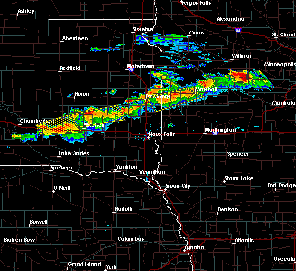 The severe thunderstorm warning for lyon, lincoln, northwestern pipestone, northeastern moody and southeastern brookings counties will expire at 530 pm cdt, the storms which prompted the warning have weakened below severe limits, and no longer pose an immediate threat to life or property. therefore the warning will be allowed to expire. however gusty winds and heavy rain are still possible with these thunderstorms. a severe thunderstorm watch remains in effect until 1100 pm cdt for east central south dakota. a severe thunderstorm watch also remains in effect until 1100 pm cdt for southwestern minnesota. The severe thunderstorm warning for lyon, lincoln, northwestern pipestone, northeastern moody and southeastern brookings counties will expire at 530 pm cdt, the storms which prompted the warning have weakened below severe limits, and no longer pose an immediate threat to life or property. therefore the warning will be allowed to expire. however gusty winds and heavy rain are still possible with these thunderstorms. a severe thunderstorm watch remains in effect until 1100 pm cdt for east central south dakota. a severe thunderstorm watch also remains in effect until 1100 pm cdt for southwestern minnesota.
|
| 7/25/2017 5:13 PM CDT |
 At 512 pm cdt, severe thunderstorms were located along a line extending from near ghent to aurora, moving southeast at 35 mph (radar indicated). Hazards include 60 mph wind gusts and quarter size hail. Hail damage to vehicles is expected. expect wind damage to roofs, siding, and trees. these severe storms will be near, marshall, ghent and camden state park around 520 pm cdt. ward around 530 pm cdt. Other locations impacted by these severe thunderstorms include bushnell and lynd. At 512 pm cdt, severe thunderstorms were located along a line extending from near ghent to aurora, moving southeast at 35 mph (radar indicated). Hazards include 60 mph wind gusts and quarter size hail. Hail damage to vehicles is expected. expect wind damage to roofs, siding, and trees. these severe storms will be near, marshall, ghent and camden state park around 520 pm cdt. ward around 530 pm cdt. Other locations impacted by these severe thunderstorms include bushnell and lynd.
|
| 7/25/2017 4:52 PM CDT |
 At 451 pm cdt, severe thunderstorms were located along a line extending from near taunton to near volga, moving east at 30 mph (trained weather spotters). Hazards include 70 mph wind gusts and ping pong ball size hail. People and animals outdoors will be injured. expect hail damage to roofs, siding, windows, and vehicles. expect considerable tree damage. wind damage is also likely to mobile homes, roofs, and outbuildings. severe thunderstorms will be near, taunton around 455 pm cdt. minneota around 500 pm cdt. aurora and ghent around 510 pm cdt. camden state park around 515 pm cdt. marshall around 525 pm cdt. elkton and ward around 530 pm cdt. Other locations impacted by these severe thunderstorms include bushnell and lynd. At 451 pm cdt, severe thunderstorms were located along a line extending from near taunton to near volga, moving east at 30 mph (trained weather spotters). Hazards include 70 mph wind gusts and ping pong ball size hail. People and animals outdoors will be injured. expect hail damage to roofs, siding, windows, and vehicles. expect considerable tree damage. wind damage is also likely to mobile homes, roofs, and outbuildings. severe thunderstorms will be near, taunton around 455 pm cdt. minneota around 500 pm cdt. aurora and ghent around 510 pm cdt. camden state park around 515 pm cdt. marshall around 525 pm cdt. elkton and ward around 530 pm cdt. Other locations impacted by these severe thunderstorms include bushnell and lynd.
|
| 7/19/2017 2:00 PM CDT |
 At 200 pm cdt, a severe thunderstorm was located over russell, or 13 miles southwest of marshall, moving east at 45 mph (radar indicated). Hazards include 60 mph wind gusts. Expect damage to roofs, siding, and trees. this severe storm will be near, balaton around 205 pm cdt. other locations impacted by this severe thunderstorm include lynd. In the last several minutes, this storm has been showing some early signs of weakening. At 200 pm cdt, a severe thunderstorm was located over russell, or 13 miles southwest of marshall, moving east at 45 mph (radar indicated). Hazards include 60 mph wind gusts. Expect damage to roofs, siding, and trees. this severe storm will be near, balaton around 205 pm cdt. other locations impacted by this severe thunderstorm include lynd. In the last several minutes, this storm has been showing some early signs of weakening.
|
| 7/19/2017 1:44 PM CDT |
 At 144 pm cdt, a severe thunderstorm was located over arco, or 21 miles west of marshall, moving east at 40 mph. this is a very dangerous storm (radar indicated). Hazards include 80 mph wind gusts and nickel size hail. Flying debris will be dangerous to those caught without shelter. mobile homes will be heavily damaged. expect considerable damage to roofs, windows, and vehicles. extensive tree damage and power outages are likely. this severe thunderstorm will be near, russell around 200 pm cdt. camden state park around 205 pm cdt. other locations impacted by this severe thunderstorm include lynd. Persons in arco need to take shelter immediately. At 144 pm cdt, a severe thunderstorm was located over arco, or 21 miles west of marshall, moving east at 40 mph. this is a very dangerous storm (radar indicated). Hazards include 80 mph wind gusts and nickel size hail. Flying debris will be dangerous to those caught without shelter. mobile homes will be heavily damaged. expect considerable damage to roofs, windows, and vehicles. extensive tree damage and power outages are likely. this severe thunderstorm will be near, russell around 200 pm cdt. camden state park around 205 pm cdt. other locations impacted by this severe thunderstorm include lynd. Persons in arco need to take shelter immediately.
|
| 7/19/2017 1:35 PM CDT |
 At 134 pm cdt, a severe thunderstorm was located 7 miles southwest of ivanhoe, or 22 miles east of brookings, moving east at 35 mph. this is a very dangerous storm (radar indicated). Hazards include 80 mph wind gusts and nickel size hail. Flying debris will be dangerous to those caught without shelter. mobile homes will be heavily damaged. expect considerable damage to roofs, windows, and vehicles. extensive tree damage and power outages are likely. this severe storm will be near, ivanhoe around 140 pm cdt. arco around 145 pm cdt. tyler around 150 pm cdt. russell and camden state park around 200 pm cdt. other locations impacted by this severe thunderstorm include lynd. the wind signature of this storm is strenghening. Persons in west central lincoln county minnesota need to take shelter immediately. At 134 pm cdt, a severe thunderstorm was located 7 miles southwest of ivanhoe, or 22 miles east of brookings, moving east at 35 mph. this is a very dangerous storm (radar indicated). Hazards include 80 mph wind gusts and nickel size hail. Flying debris will be dangerous to those caught without shelter. mobile homes will be heavily damaged. expect considerable damage to roofs, windows, and vehicles. extensive tree damage and power outages are likely. this severe storm will be near, ivanhoe around 140 pm cdt. arco around 145 pm cdt. tyler around 150 pm cdt. russell and camden state park around 200 pm cdt. other locations impacted by this severe thunderstorm include lynd. the wind signature of this storm is strenghening. Persons in west central lincoln county minnesota need to take shelter immediately.
|
| 7/19/2017 1:15 PM CDT |
 At 115 pm cdt, a severe thunderstorm was located 8 miles north of elkton, or 16 miles east of brookings, moving east at 50 mph (radar indicated). Hazards include 60 mph wind gusts and nickel size hail. Expect damage to roofs, siding, and trees. this severe thunderstorm will be near, lake benton around 125 pm cdt. arco around 130 pm cdt. tyler around 135 pm cdt. russell around 145 pm cdt. camden state park around 150 pm cdt. Other locations impacted by this severe thunderstorm include bushnell and lynd. At 115 pm cdt, a severe thunderstorm was located 8 miles north of elkton, or 16 miles east of brookings, moving east at 50 mph (radar indicated). Hazards include 60 mph wind gusts and nickel size hail. Expect damage to roofs, siding, and trees. this severe thunderstorm will be near, lake benton around 125 pm cdt. arco around 130 pm cdt. tyler around 135 pm cdt. russell around 145 pm cdt. camden state park around 150 pm cdt. Other locations impacted by this severe thunderstorm include bushnell and lynd.
|
| 7/11/2017 11:30 PM CDT |
 At 1129 pm cdt, severe thunderstorms were located along a line extending from near lake benton to 7 miles east of ward to 6 miles northwest of pipestone national monument, moving southeast at 20 mph (radar indicated). Hazards include 60 mph wind gusts and nickel size hail. Expect damage to roofs, siding, and trees. These severe storms will be near, pipestone, tyler, holland and pipestone national monument around 1145 pm cdt. At 1129 pm cdt, severe thunderstorms were located along a line extending from near lake benton to 7 miles east of ward to 6 miles northwest of pipestone national monument, moving southeast at 20 mph (radar indicated). Hazards include 60 mph wind gusts and nickel size hail. Expect damage to roofs, siding, and trees. These severe storms will be near, pipestone, tyler, holland and pipestone national monument around 1145 pm cdt.
|
| 7/11/2017 11:25 PM CDT |
 At 1124 pm cdt, severe thunderstorms were located along a line extending from near arco to near lake benton to near ward to flandreau to colman, moving southeast at 40 mph (radar indicated). Hazards include 60 mph wind gusts and nickel size hail. Expect damage to roofs, siding, and trees. these severe storms will be near, lake benton around 1130 pm cdt. Pipestone, tyler, holland and pipestone national monument around 1135 pm cdt. At 1124 pm cdt, severe thunderstorms were located along a line extending from near arco to near lake benton to near ward to flandreau to colman, moving southeast at 40 mph (radar indicated). Hazards include 60 mph wind gusts and nickel size hail. Expect damage to roofs, siding, and trees. these severe storms will be near, lake benton around 1130 pm cdt. Pipestone, tyler, holland and pipestone national monument around 1135 pm cdt.
|
| 7/11/2017 11:10 PM CDT |
 At 1110 pm cdt, severe thunderstorms were located along a line extending from 7 miles southwest of ivanhoe to near elkton to near ward to 8 miles northwest of flandreau to 7 miles east of nunda, moving southeast at 35 mph (radar indicated). Hazards include 60 mph wind gusts and nickel size hail. Expect damage to roofs, siding, and trees. severe thunderstorms will be near, ward around 1115 pm cdt. flandreau, lake benton and egan around 1125 pm cdt. tyler and colman around 1130 pm cdt. Pipestone, holland and pipestone national monument around 1135 pm cdt. At 1110 pm cdt, severe thunderstorms were located along a line extending from 7 miles southwest of ivanhoe to near elkton to near ward to 8 miles northwest of flandreau to 7 miles east of nunda, moving southeast at 35 mph (radar indicated). Hazards include 60 mph wind gusts and nickel size hail. Expect damage to roofs, siding, and trees. severe thunderstorms will be near, ward around 1115 pm cdt. flandreau, lake benton and egan around 1125 pm cdt. tyler and colman around 1130 pm cdt. Pipestone, holland and pipestone national monument around 1135 pm cdt.
|
| 6/13/2017 9:35 PM CDT |
 At 935 pm cdt, severe thunderstorms were located along a line extending from near tyler to trosky, moving northeast at 45 mph (radar indicated). Hazards include 70 mph wind gusts and penny size hail. Expect considerable tree damage. damage is likely to mobile homes, roofs, and outbuildings. these severe storms will be near, tyler and florence around 940 pm cdt. balaton and russell around 945 pm cdt. woodstock and camden state park around 950 pm cdt. chandler around 955 pm cdt. marshall, lake wilson and current lake around 1000 pm cdt. other locations impacted by these severe thunderstorms include ihlen, hatfield, lynd, garvin and hadley. A tornado watch remains in effect until 200 am cdt for southwestern minnesota, and southeastern and east central south dakota. At 935 pm cdt, severe thunderstorms were located along a line extending from near tyler to trosky, moving northeast at 45 mph (radar indicated). Hazards include 70 mph wind gusts and penny size hail. Expect considerable tree damage. damage is likely to mobile homes, roofs, and outbuildings. these severe storms will be near, tyler and florence around 940 pm cdt. balaton and russell around 945 pm cdt. woodstock and camden state park around 950 pm cdt. chandler around 955 pm cdt. marshall, lake wilson and current lake around 1000 pm cdt. other locations impacted by these severe thunderstorms include ihlen, hatfield, lynd, garvin and hadley. A tornado watch remains in effect until 200 am cdt for southwestern minnesota, and southeastern and east central south dakota.
|
| 6/13/2017 9:18 PM CDT |
 At 918 pm cdt, a severe thunderstorm was located near ward, or 7 miles north of pipestone, moving northeast at 55 mph (radar indicated). Hazards include 70 mph wind gusts and penny size hail. Expect considerable tree damage. damage is likely to mobile homes, roofs, and outbuildings. this severe thunderstorm will be near, holland around 925 pm cdt. tyler and ruthton around 935 pm cdt. florence around 940 pm cdt. balaton and russell around 945 pm cdt. camden state park around 950 pm cdt. marshall around 1000 pm cdt. other locations impacted by this severe thunderstorm include ihlen, hatfield, lynd, garvin and hadley. A tornado watch remains in effect until 200 am cdt for southwestern minnesota, and southeastern and east central south dakota. At 918 pm cdt, a severe thunderstorm was located near ward, or 7 miles north of pipestone, moving northeast at 55 mph (radar indicated). Hazards include 70 mph wind gusts and penny size hail. Expect considerable tree damage. damage is likely to mobile homes, roofs, and outbuildings. this severe thunderstorm will be near, holland around 925 pm cdt. tyler and ruthton around 935 pm cdt. florence around 940 pm cdt. balaton and russell around 945 pm cdt. camden state park around 950 pm cdt. marshall around 1000 pm cdt. other locations impacted by this severe thunderstorm include ihlen, hatfield, lynd, garvin and hadley. A tornado watch remains in effect until 200 am cdt for southwestern minnesota, and southeastern and east central south dakota.
|
| 6/11/2017 6:55 AM CDT |
 At 655 am cdt, severe thunderstorms were located along a line extending from near echo to near balaton to leota, moving east at 45 mph (radar indicated). Hazards include 60 mph wind gusts and quarter size hail. Hail damage to vehicles is expected. expect wind damage to roofs, siding, and trees. these severe storms will be near, tracy around 710 am cdt. Other locations impacted by these severe thunderstorms include ihlen, avoca, lynd, garvin, hadley, iona and hatfield. At 655 am cdt, severe thunderstorms were located along a line extending from near echo to near balaton to leota, moving east at 45 mph (radar indicated). Hazards include 60 mph wind gusts and quarter size hail. Hail damage to vehicles is expected. expect wind damage to roofs, siding, and trees. these severe storms will be near, tracy around 710 am cdt. Other locations impacted by these severe thunderstorms include ihlen, avoca, lynd, garvin, hadley, iona and hatfield.
|
| 6/11/2017 6:40 AM CDT |
 At 638 am cdt, severe thunderstorms were located along a line extending from near cottonwood to near florence to near trosky, moving east at 45 mph (radar indicated). Hazards include 60 mph wind gusts and quarter size hail. Hail damage to vehicles is expected. expect wind damage to roofs, siding, and trees. severe thunderstorms will be near, cottonwood around 645 am cdt. balaton around 650 am cdt. chandler and lake shetek state park around 700 am cdt. tracy around 705 am cdt. at 616 am, 62 mph winds were reported at lake benton. Other locations impacted by these severe thunderstorms include ihlen, avoca, lynd, garvin, hadley, iona and hatfield. At 638 am cdt, severe thunderstorms were located along a line extending from near cottonwood to near florence to near trosky, moving east at 45 mph (radar indicated). Hazards include 60 mph wind gusts and quarter size hail. Hail damage to vehicles is expected. expect wind damage to roofs, siding, and trees. severe thunderstorms will be near, cottonwood around 645 am cdt. balaton around 650 am cdt. chandler and lake shetek state park around 700 am cdt. tracy around 705 am cdt. at 616 am, 62 mph winds were reported at lake benton. Other locations impacted by these severe thunderstorms include ihlen, avoca, lynd, garvin, hadley, iona and hatfield.
|
| 6/11/2017 6:35 AM CDT |
 At 635 am cdt, severe thunderstorms were located along a line extending from near minneota to ruthton to jasper, moving east at 45 mph (radar indicated). Hazards include 60 mph wind gusts and half dollar size hail. Hail damage to vehicles is expected. expect wind damage to roofs, siding, and trees. these severe storms will be near, minneota, ghent and florence around 640 am cdt. cottonwood, edgerton, balaton and current lake around 645 am cdt. Other locations impacted by these severe thunderstorms include ihlen, hatfield, lynd, garvin and hadley. At 635 am cdt, severe thunderstorms were located along a line extending from near minneota to ruthton to jasper, moving east at 45 mph (radar indicated). Hazards include 60 mph wind gusts and half dollar size hail. Hail damage to vehicles is expected. expect wind damage to roofs, siding, and trees. these severe storms will be near, minneota, ghent and florence around 640 am cdt. cottonwood, edgerton, balaton and current lake around 645 am cdt. Other locations impacted by these severe thunderstorms include ihlen, hatfield, lynd, garvin and hadley.
|
| 6/11/2017 6:25 AM CDT |
 At 625 am cdt, severe thunderstorms were located along a line extending from near taunton to near ruthton to 6 miles southeast of trent, moving east at 45 mph (radar indicated). Hazards include 60 mph wind gusts and quarter size hail. Hail damage to vehicles is expected. expect wind damage to roofs, siding, and trees. these severe storms will be near, tyler, holland and taunton around 630 am cdt. minneota, ruthton and florence around 635 am cdt. ghent around 640 am cdt. cottonwood, edgerton, balaton, trosky and current lake around 645 am cdt. Other locations impacted by these severe thunderstorms include ihlen, hatfield, lynd, garvin and hadley. At 625 am cdt, severe thunderstorms were located along a line extending from near taunton to near ruthton to 6 miles southeast of trent, moving east at 45 mph (radar indicated). Hazards include 60 mph wind gusts and quarter size hail. Hail damage to vehicles is expected. expect wind damage to roofs, siding, and trees. these severe storms will be near, tyler, holland and taunton around 630 am cdt. minneota, ruthton and florence around 635 am cdt. ghent around 640 am cdt. cottonwood, edgerton, balaton, trosky and current lake around 645 am cdt. Other locations impacted by these severe thunderstorms include ihlen, hatfield, lynd, garvin and hadley.
|
| 6/11/2017 6:07 AM CDT |
 At 607 am cdt, severe thunderstorms were located along a line extending from 7 miles north of hendricks to near ward to near dell rapids, moving east at 45 mph (radar indicated). Hazards include 60 mph wind gusts and half dollar size hail. Hail damage to vehicles is expected. expect wind damage to roofs, siding, and trees. severe thunderstorms will be near, elkton, hendricks and ward around 610 am cdt. lake benton around 620 am cdt. holland around 625 am cdt. tyler, ruthton and taunton around 630 am cdt. minneota, jasper and florence around 635 am cdt. ghent and current lake around 640 am cdt. cottonwood, edgerton, balaton and trosky around 645 am cdt. Other locations impacted by these severe thunderstorms include ihlen, hatfield, bushnell, lynd, garvin and hadley. At 607 am cdt, severe thunderstorms were located along a line extending from 7 miles north of hendricks to near ward to near dell rapids, moving east at 45 mph (radar indicated). Hazards include 60 mph wind gusts and half dollar size hail. Hail damage to vehicles is expected. expect wind damage to roofs, siding, and trees. severe thunderstorms will be near, elkton, hendricks and ward around 610 am cdt. lake benton around 620 am cdt. holland around 625 am cdt. tyler, ruthton and taunton around 630 am cdt. minneota, jasper and florence around 635 am cdt. ghent and current lake around 640 am cdt. cottonwood, edgerton, balaton and trosky around 645 am cdt. Other locations impacted by these severe thunderstorms include ihlen, hatfield, bushnell, lynd, garvin and hadley.
|
| 9/24/2016 4:02 PM CDT |
 At 402 pm cdt, severe thunderstorms were located along a line extending from tyler to 6 miles northwest of slayton, moving northeast at 55 mph (radar indicated). Hazards include 60 mph wind gusts. Expect damage to roofs. siding. and trees. severe thunderstorms will be near, russell and camden state park around 410 pm cdt. marshall, tracy and ghent around 420 pm cdt. Other locations impacted by these severe thunderstorms include garvin, hadley and lynd. At 402 pm cdt, severe thunderstorms were located along a line extending from tyler to 6 miles northwest of slayton, moving northeast at 55 mph (radar indicated). Hazards include 60 mph wind gusts. Expect damage to roofs. siding. and trees. severe thunderstorms will be near, russell and camden state park around 410 pm cdt. marshall, tracy and ghent around 420 pm cdt. Other locations impacted by these severe thunderstorms include garvin, hadley and lynd.
|
| 9/24/2016 3:51 PM CDT |
 At 350 pm cdt, severe thunderstorms were located along a line extending from ruthton to near lake wilson, moving northeast at 55 mph (radar indicated). Hazards include 60 mph wind gusts. Expect damage to roofs. siding. and trees. these severe storms will be near, florence around 355 pm cdt. tyler, russell, current lake and lake shetek state park around 400 pm cdt. Other locations impacted by these severe thunderstorms include garvin, hadley, lynd and hatfield. At 350 pm cdt, severe thunderstorms were located along a line extending from ruthton to near lake wilson, moving northeast at 55 mph (radar indicated). Hazards include 60 mph wind gusts. Expect damage to roofs. siding. and trees. these severe storms will be near, florence around 355 pm cdt. tyler, russell, current lake and lake shetek state park around 400 pm cdt. Other locations impacted by these severe thunderstorms include garvin, hadley, lynd and hatfield.
|
| 9/24/2016 3:32 PM CDT |
 At 331 pm cdt, severe thunderstorms were located along a line extending from near pipestone to near leota, moving northeast at 65 mph (radar indicated). Hazards include 60 mph wind gusts. Expect damage to roofs. siding. and trees. severe thunderstorms will be near, woodstock around 335 pm cdt. chandler and holland around 340 pm cdt. lake wilson and ruthton around 345 pm cdt. tyler, florence and current lake around 350 pm cdt. russell and lake shetek state park around 355 pm cdt. camden state park around 400 pm cdt. Other locations impacted by these severe thunderstorms include garvin, hatfield, hadley, lynd and kenneth. At 331 pm cdt, severe thunderstorms were located along a line extending from near pipestone to near leota, moving northeast at 65 mph (radar indicated). Hazards include 60 mph wind gusts. Expect damage to roofs. siding. and trees. severe thunderstorms will be near, woodstock around 335 pm cdt. chandler and holland around 340 pm cdt. lake wilson and ruthton around 345 pm cdt. tyler, florence and current lake around 350 pm cdt. russell and lake shetek state park around 355 pm cdt. camden state park around 400 pm cdt. Other locations impacted by these severe thunderstorms include garvin, hatfield, hadley, lynd and kenneth.
|
| 8/12/2016 12:27 AM CDT |
 At 1227 am cdt, severe thunderstorms were located along a line extending from 7 miles southwest of toronto to near white to 8 miles northwest of flandreau, moving east at 35 mph (radar indicated). Hazards include 60 mph wind gusts. Expect damage to roofs. siding. and trees. severe thunderstorms will be near, white around 1230 am cdt. ward around 1250 am cdt. elkton and hendricks around 1255 am cdt. ivanhoe around 100 am cdt. arco around 105 am cdt. lake benton around 110 am cdt. tyler and ruthton around 115 am cdt. Other locations impacted by these severe thunderstorms include bushnell. At 1227 am cdt, severe thunderstorms were located along a line extending from 7 miles southwest of toronto to near white to 8 miles northwest of flandreau, moving east at 35 mph (radar indicated). Hazards include 60 mph wind gusts. Expect damage to roofs. siding. and trees. severe thunderstorms will be near, white around 1230 am cdt. ward around 1250 am cdt. elkton and hendricks around 1255 am cdt. ivanhoe around 100 am cdt. arco around 105 am cdt. lake benton around 110 am cdt. tyler and ruthton around 115 am cdt. Other locations impacted by these severe thunderstorms include bushnell.
|
| 8/11/2016 1:58 AM CDT | The severe thunderstorm warning for southern lincoln, pipestone, southwestern lyon, northwestern rock, northern minnehaha, moody, northeastern mccook, southeastern brookings and southeastern lake counties will expire at 200 am cdt, the storms which prompted the warning have weakened below severe limits, and no longer pose an immediate threat to life or property. therefore, the warning will be allowed to expire. |
| 8/11/2016 1:58 AM CDT | The severe thunderstorm warning for southern lincoln, pipestone, southwestern lyon, northwestern rock, northern minnehaha, moody, northeastern mccook, southeastern brookings and southeastern lake counties will expire at 200 am cdt, the storms which prompted the warning have weakened below severe limits, and no longer pose an immediate threat to life or property. therefore, the warning will be allowed to expire. |
| 8/11/2016 1:43 AM CDT |
 At 142 am cdt, severe thunderstorms were located along a line extending from 7 miles northwest of lake benton to chester, moving east at 50 mph (radar indicated). Hazards include 60 mph wind gusts. Expect damage to roofs. siding. and trees. these severe storms will be near, lake benton around 145 am cdt. dell rapids and arco around 150 am cdt. tyler, egan and trent around 155 am cdt. jasper, russell and camden state park around 200 am cdt. Other locations impacted by these severe thunderstorms include ihlen, lynd and bushnell. At 142 am cdt, severe thunderstorms were located along a line extending from 7 miles northwest of lake benton to chester, moving east at 50 mph (radar indicated). Hazards include 60 mph wind gusts. Expect damage to roofs. siding. and trees. these severe storms will be near, lake benton around 145 am cdt. dell rapids and arco around 150 am cdt. tyler, egan and trent around 155 am cdt. jasper, russell and camden state park around 200 am cdt. Other locations impacted by these severe thunderstorms include ihlen, lynd and bushnell.
|
| 8/11/2016 1:26 AM CDT |
 At 126 am cdt, severe thunderstorms were located along a line extending from near aurora to near orland, moving east at 70 mph (radar indicated). Hazards include 60 mph wind gusts. Expect damage to roofs. siding. and trees. severe thunderstorms will be near, aurora around 130 am cdt. elkton around 135 am cdt. wentworth and chester around 140 am cdt. lake benton and colman around 145 am cdt. dell rapids, tyler and arco around 150 am cdt. egan, trent and florence around 155 am cdt. jasper, russell and camden state park around 200 am cdt. Other locations impacted by these severe thunderstorms include ihlen, lynd and bushnell. At 126 am cdt, severe thunderstorms were located along a line extending from near aurora to near orland, moving east at 70 mph (radar indicated). Hazards include 60 mph wind gusts. Expect damage to roofs. siding. and trees. severe thunderstorms will be near, aurora around 130 am cdt. elkton around 135 am cdt. wentworth and chester around 140 am cdt. lake benton and colman around 145 am cdt. dell rapids, tyler and arco around 150 am cdt. egan, trent and florence around 155 am cdt. jasper, russell and camden state park around 200 am cdt. Other locations impacted by these severe thunderstorms include ihlen, lynd and bushnell.
|
| 7/17/2016 12:15 AM CDT |
 At 1215 am cdt, severe thunderstorms were located along a line extending from near dovray to near balaton to near lake benton, moving southeast at 15 mph (radar indicated). Hazards include 60 mph wind gusts and penny size hail. Expect damage to roofs. siding. and trees. these severe storms will be near, dovray around 1220 am cdt. westbrook around 1230 am cdt. ruthton, currie, florence and lake shetek state park around 100 am cdt. Other locations impacted by these severe thunderstorms include garvin, avoca and hadley. At 1215 am cdt, severe thunderstorms were located along a line extending from near dovray to near balaton to near lake benton, moving southeast at 15 mph (radar indicated). Hazards include 60 mph wind gusts and penny size hail. Expect damage to roofs. siding. and trees. these severe storms will be near, dovray around 1220 am cdt. westbrook around 1230 am cdt. ruthton, currie, florence and lake shetek state park around 100 am cdt. Other locations impacted by these severe thunderstorms include garvin, avoca and hadley.
|
| 7/16/2016 11:54 PM CDT |
 At 1153 pm cdt, a severe thunderstorm was located near ruthton, or 15 miles northeast of pipestone, moving east at 45 mph (radar indicated). Hazards include 70 mph wind gusts and quarter size hail. Hail damage to vehicles is expected. expect considerable tree damage. wind damage is also likely to mobile homes, roofs, and outbuildings. this severe thunderstorm will be near, florence around 1200 am cdt. balaton and current lake around 1210 am cdt. slayton and lake shetek state park around 1225 am cdt. currie around 1230 am cdt. dovray around 1240 am cdt. westbrook around 1245 am cdt. Other locations impacted by this severe thunderstorm include garvin, avoca and hadley. At 1153 pm cdt, a severe thunderstorm was located near ruthton, or 15 miles northeast of pipestone, moving east at 45 mph (radar indicated). Hazards include 70 mph wind gusts and quarter size hail. Hail damage to vehicles is expected. expect considerable tree damage. wind damage is also likely to mobile homes, roofs, and outbuildings. this severe thunderstorm will be near, florence around 1200 am cdt. balaton and current lake around 1210 am cdt. slayton and lake shetek state park around 1225 am cdt. currie around 1230 am cdt. dovray around 1240 am cdt. westbrook around 1245 am cdt. Other locations impacted by this severe thunderstorm include garvin, avoca and hadley.
|
| 7/16/2016 11:29 PM CDT |
 At 1129 pm cdt, a severe thunderstorm was located near lake benton, or 21 miles north of pipestone, moving east at 30 mph. this is a very dangerous storm (radar indicated). Hazards include 80 mph wind gusts and half dollar size hail. Flying debris will be dangerous to those caught without shelter. mobile homes will be heavily damaged. expect considerable damage to roofs, windows, and vehicles. extensive tree damage and power outages are likely. this severe storm will be near, arco around 1135 pm cdt. tyler around 1145 pm cdt. russell and florence around 1155 pm cdt. balaton around 1200 am cdt. Other locations impacted by this severe thunderstorm include lynd. At 1129 pm cdt, a severe thunderstorm was located near lake benton, or 21 miles north of pipestone, moving east at 30 mph. this is a very dangerous storm (radar indicated). Hazards include 80 mph wind gusts and half dollar size hail. Flying debris will be dangerous to those caught without shelter. mobile homes will be heavily damaged. expect considerable damage to roofs, windows, and vehicles. extensive tree damage and power outages are likely. this severe storm will be near, arco around 1135 pm cdt. tyler around 1145 pm cdt. russell and florence around 1155 pm cdt. balaton around 1200 am cdt. Other locations impacted by this severe thunderstorm include lynd.
|
| 7/16/2016 11:13 PM CDT |
 At 1112 pm cdt, a severe thunderstorm was located near lake benton, or 21 miles east of brookings, moving east at 25 mph. this is a very dangerous storm (radar indicated). Hazards include 80 mph wind gusts and half dollar size hail. Flying debris will be dangerous to those caught without shelter. mobile homes will be heavily damaged. expect considerable damage to roofs, windows, and vehicles. extensive tree damage and power outages are likely. this severe thunderstorm will be near, lake benton around 1125 pm cdt. arco around 1130 pm cdt. tyler around 1140 pm cdt. florence around 1150 pm cdt. russell around 1155 pm cdt. balaton and camden state park around 1200 am cdt. Other locations impacted by this severe thunderstorm include lynd. At 1112 pm cdt, a severe thunderstorm was located near lake benton, or 21 miles east of brookings, moving east at 25 mph. this is a very dangerous storm (radar indicated). Hazards include 80 mph wind gusts and half dollar size hail. Flying debris will be dangerous to those caught without shelter. mobile homes will be heavily damaged. expect considerable damage to roofs, windows, and vehicles. extensive tree damage and power outages are likely. this severe thunderstorm will be near, lake benton around 1125 pm cdt. arco around 1130 pm cdt. tyler around 1140 pm cdt. florence around 1150 pm cdt. russell around 1155 pm cdt. balaton and camden state park around 1200 am cdt. Other locations impacted by this severe thunderstorm include lynd.
|
| 7/16/2016 10:24 PM CDT |
 At 1024 pm cdt, a severe thunderstorm was located near tyler, or 16 miles southwest of marshall, moving east at 15 mph (radar indicated). Hazards include 70 mph wind gusts and half dollar size hail. Hail damage to vehicles is expected. expect considerable tree damage. wind damage is also likely to mobile homes, roofs, and outbuildings. this severe thunderstorm will be near, florence around 1035 pm cdt. russell around 1045 pm cdt. camden state park around 1050 pm cdt. balaton around 1110 pm cdt. Other locations impacted by this severe thunderstorm include lynd. At 1024 pm cdt, a severe thunderstorm was located near tyler, or 16 miles southwest of marshall, moving east at 15 mph (radar indicated). Hazards include 70 mph wind gusts and half dollar size hail. Hail damage to vehicles is expected. expect considerable tree damage. wind damage is also likely to mobile homes, roofs, and outbuildings. this severe thunderstorm will be near, florence around 1035 pm cdt. russell around 1045 pm cdt. camden state park around 1050 pm cdt. balaton around 1110 pm cdt. Other locations impacted by this severe thunderstorm include lynd.
|
| 6/17/2016 5:23 PM CDT |
 At 522 pm cdt, a severe thunderstorm was located near ivanhoe, or 24 miles southeast of clear lake, moving south at 15 mph (radar indicated). Hazards include 60 mph wind gusts and half dollar size hail. Hail damage to vehicles is expected. expect wind damage to roofs, siding, and trees. this severe thunderstorm will be near, ivanhoe around 535 pm cdt. arco around 550 pm cdt. Lake benton around 600 pm cdt. At 522 pm cdt, a severe thunderstorm was located near ivanhoe, or 24 miles southeast of clear lake, moving south at 15 mph (radar indicated). Hazards include 60 mph wind gusts and half dollar size hail. Hail damage to vehicles is expected. expect wind damage to roofs, siding, and trees. this severe thunderstorm will be near, ivanhoe around 535 pm cdt. arco around 550 pm cdt. Lake benton around 600 pm cdt.
|
| 6/20/2015 3:40 AM CDT |
 At 340 am cdt, severe thunderstorms were located along a line extending from 6 miles southwest of ivanhoe to near trosky to near larchwood, moving east at 65 mph (radar indicated). Hazards include 60 mph wind gusts. Expect damage to roofs. siding and trees. these severe storms will be near, edgerton and arco around 345 am cdt. tyler, leota and lake wilson around 350 am cdt. rock rapids and chandler around 355 am cdt. ellsworth, russell and camden state park around 400 am cdt. Other locations impacted by these severe thunderstorms include hatfield, magnolia, ihlen, lynd, kenneth, garvin, hadley, iona, steen and avoca. At 340 am cdt, severe thunderstorms were located along a line extending from 6 miles southwest of ivanhoe to near trosky to near larchwood, moving east at 65 mph (radar indicated). Hazards include 60 mph wind gusts. Expect damage to roofs. siding and trees. these severe storms will be near, edgerton and arco around 345 am cdt. tyler, leota and lake wilson around 350 am cdt. rock rapids and chandler around 355 am cdt. ellsworth, russell and camden state park around 400 am cdt. Other locations impacted by these severe thunderstorms include hatfield, magnolia, ihlen, lynd, kenneth, garvin, hadley, iona, steen and avoca.
|
| 6/20/2015 3:32 AM CDT |
 At 332 am cdt, severe thunderstorms were located along a line extending from 8 miles south of hendricks to trosky to near lake alvin state recreation area, moving east at 60 mph (radar indicated). Hazards include 60 mph wind gusts. Expect damage to roofs. siding and trees. these severe storms will be near, edgerton around 340 am cdt. tyler, leota, chandler and arco around 345 am cdt. Other locations impacted by these severe thunderstorms include hatfield, magnolia, ihlen, lynd, kenneth, garvin, hadley, iona, steen and bushnell. At 332 am cdt, severe thunderstorms were located along a line extending from 8 miles south of hendricks to trosky to near lake alvin state recreation area, moving east at 60 mph (radar indicated). Hazards include 60 mph wind gusts. Expect damage to roofs. siding and trees. these severe storms will be near, edgerton around 340 am cdt. tyler, leota, chandler and arco around 345 am cdt. Other locations impacted by these severe thunderstorms include hatfield, magnolia, ihlen, lynd, kenneth, garvin, hadley, iona, steen and bushnell.
|
| 6/20/2015 3:19 AM CDT |
 At 319 am cdt, severe thunderstorms were located along a line extending from near white to near trent to near tea, moving east at 65 mph (radar indicated). Hazards include 70 mph wind gusts. Expect considerable tree damage. damage is likely to mobile homes, roofs and outbuildings. severe thunderstorms will be near, jasper around 325 am cdt. lake alvin state recreation area, pipestone national monument and pipestone national monument around 330 am cdt. trosky and rowena around 335 am cdt. edgerton, larchwood, valley springs, lake benton, ivanhoe, woodstock and arco around 340 am cdt. tyler, hills, leota, lester, chandler and lake wilson around 345 am cdt. rock rapids and russell around 350 am cdt. slayton and camden state park around 355 am cdt. marshall and ellsworth around 400 am cdt. Other locations impacted by these severe thunderstorms include hatfield, magnolia, ihlen, lynd, kenneth, garvin, hadley, iona, steen and bushnell. At 319 am cdt, severe thunderstorms were located along a line extending from near white to near trent to near tea, moving east at 65 mph (radar indicated). Hazards include 70 mph wind gusts. Expect considerable tree damage. damage is likely to mobile homes, roofs and outbuildings. severe thunderstorms will be near, jasper around 325 am cdt. lake alvin state recreation area, pipestone national monument and pipestone national monument around 330 am cdt. trosky and rowena around 335 am cdt. edgerton, larchwood, valley springs, lake benton, ivanhoe, woodstock and arco around 340 am cdt. tyler, hills, leota, lester, chandler and lake wilson around 345 am cdt. rock rapids and russell around 350 am cdt. slayton and camden state park around 355 am cdt. marshall and ellsworth around 400 am cdt. Other locations impacted by these severe thunderstorms include hatfield, magnolia, ihlen, lynd, kenneth, garvin, hadley, iona, steen and bushnell.
|
| 6/9/2015 6:29 PM CDT |
 At 628 pm cdt, severe thunderstorms were located along a line extending from near arco to near elkton, moving southeast at 45 mph (radar indicated). Hazards include 60 mph wind gusts. Expect damage to roofs. siding and trees. severe thunderstorms will be near, tyler around 635 pm cdt. ruthton and florence around 645 pm cdt. balaton and holland around 650 pm cdt. current lake around 655 pm cdt. woodstock around 700 pm cdt. lake wilson around 705 pm cdt. slayton, chandler and lake shetek state park around 710 pm cdt. currie around 715 pm cdt. Other locations impacted by these severe thunderstorms include hadley, garvin and hatfield. At 628 pm cdt, severe thunderstorms were located along a line extending from near arco to near elkton, moving southeast at 45 mph (radar indicated). Hazards include 60 mph wind gusts. Expect damage to roofs. siding and trees. severe thunderstorms will be near, tyler around 635 pm cdt. ruthton and florence around 645 pm cdt. balaton and holland around 650 pm cdt. current lake around 655 pm cdt. woodstock around 700 pm cdt. lake wilson around 705 pm cdt. slayton, chandler and lake shetek state park around 710 pm cdt. currie around 715 pm cdt. Other locations impacted by these severe thunderstorms include hadley, garvin and hatfield.
|
| 6/21/2013 10:40 PM CDT | Golf Ball sized hail reported 3.8 miles N of Tyler, MN |
| 6/19/2012 1:37 AM CDT | Ping Pong Ball sized hail reported 7.2 miles SE of Tyler, MN |
| 4/15/2012 3:28 PM CDT | Quarter sized hail reported 4.7 miles SW of Tyler, MN, ground was white with hail up to the size of quarters. |
| 1/1/0001 12:00 AM | Golf Ball sized hail reported 0.4 miles SSE of Tyler, MN, also very strong stright line winds uprooted trees. |
| 1/1/0001 12:00 AM | Lost of tree damag in lincoln county MN, 0.4 miles SSE of Tyler, MN |
| 1/1/0001 12:00 AM | Lots of tree damag in lincoln county MN, 0.4 miles SSE of Tyler, MN |
| 1/1/0001 12:00 AM | Golf Ball sized hail reported 0.4 miles SSE of Tyler, MN |
Hail Maps for Tyler, MN
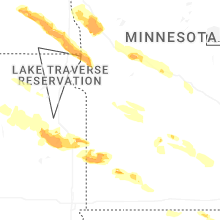


Connect with Interactive Hail Maps