

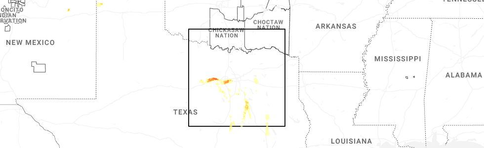
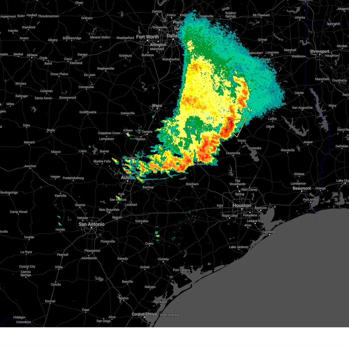
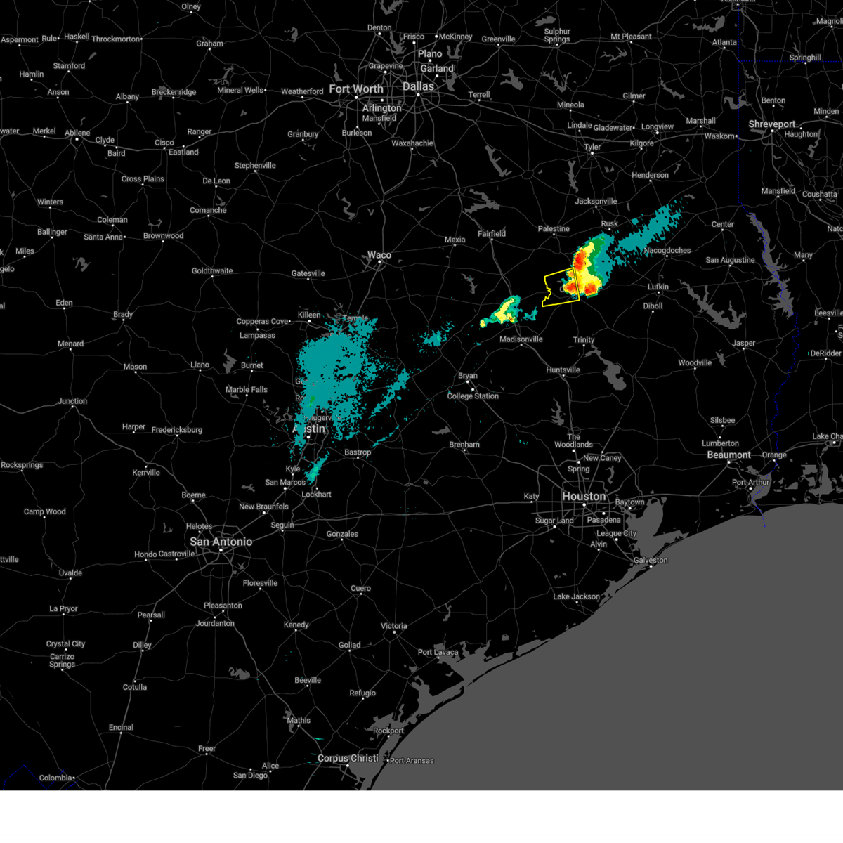
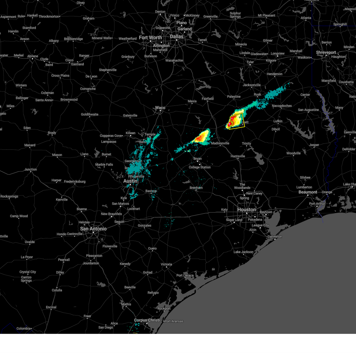
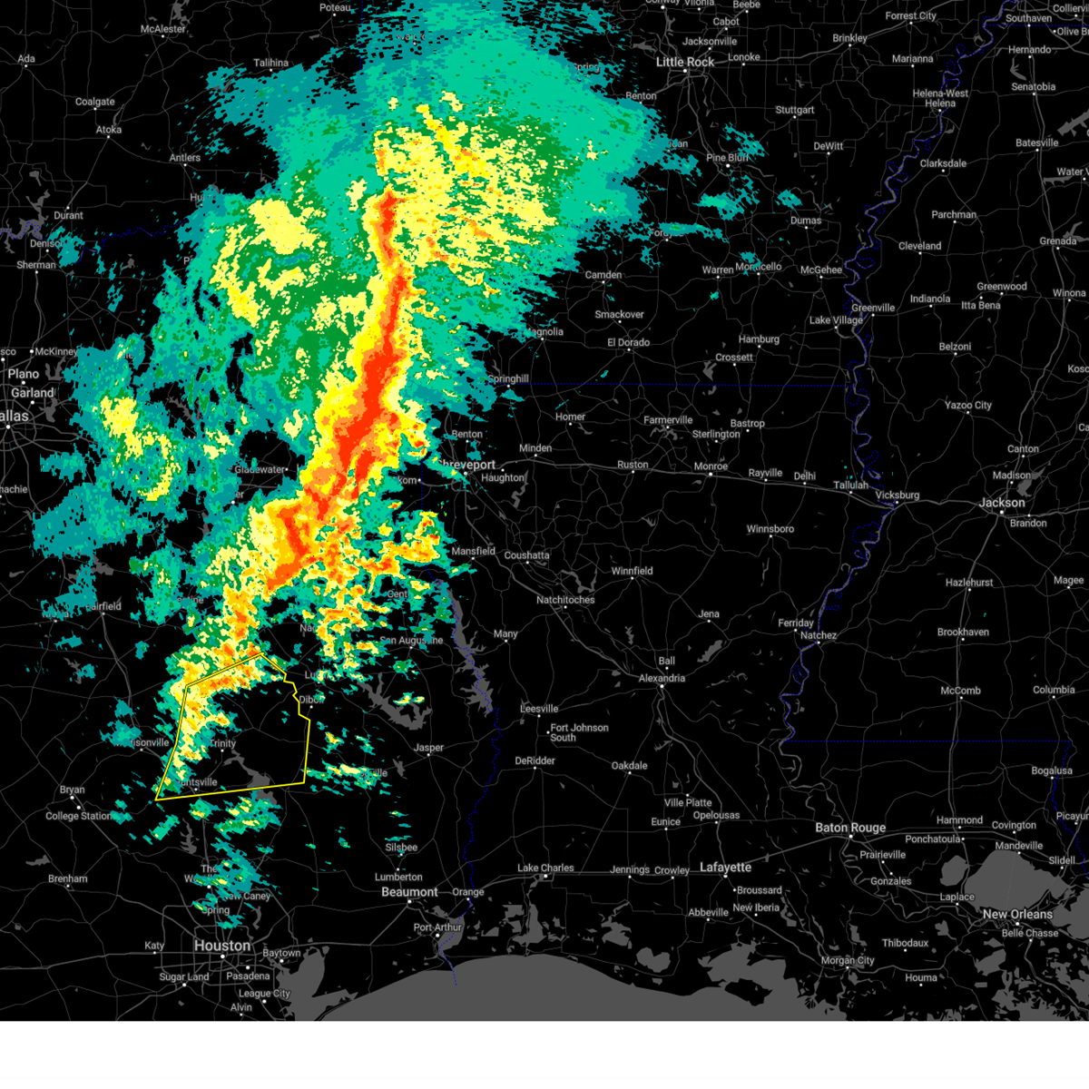
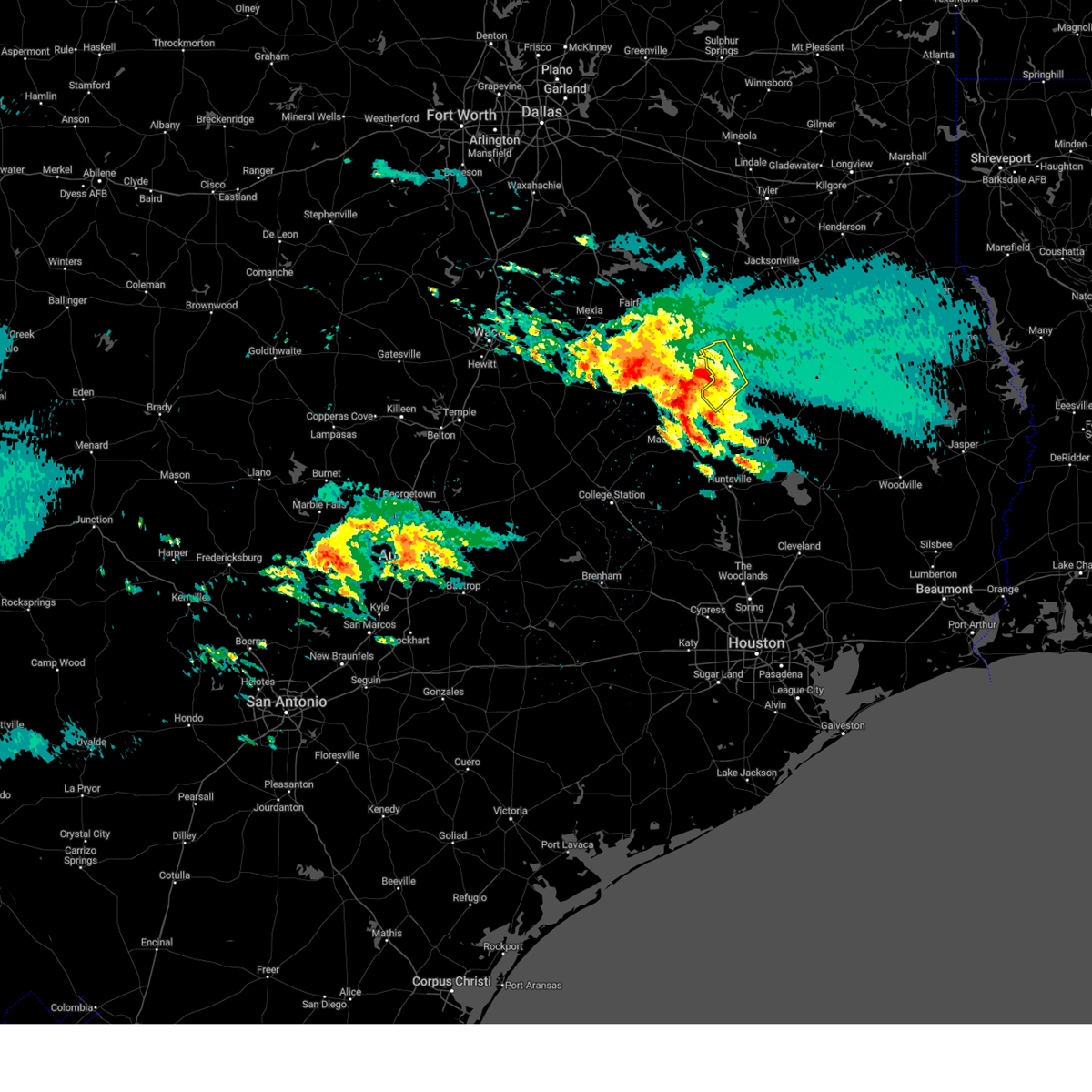
Hail Map for Crockett, TX
The Crockett, TX area has had 13 reports of on-the-ground hail by trained spotters, and has been under severe weather warnings 17 times during the past 12 months. Doppler radar has detected hail at or near Crockett, TX on 59 occasions, including 6 occasions during the past year.
| Name: | Crockett, TX |
| Where Located: | 43.6 miles W of Lufkin, TX |
| Map: | Google Map for Crockett, TX |
| Population: | 6950 |
| Housing Units: | 3122 |
| More Info: | Search Google for Crockett, TX |
3
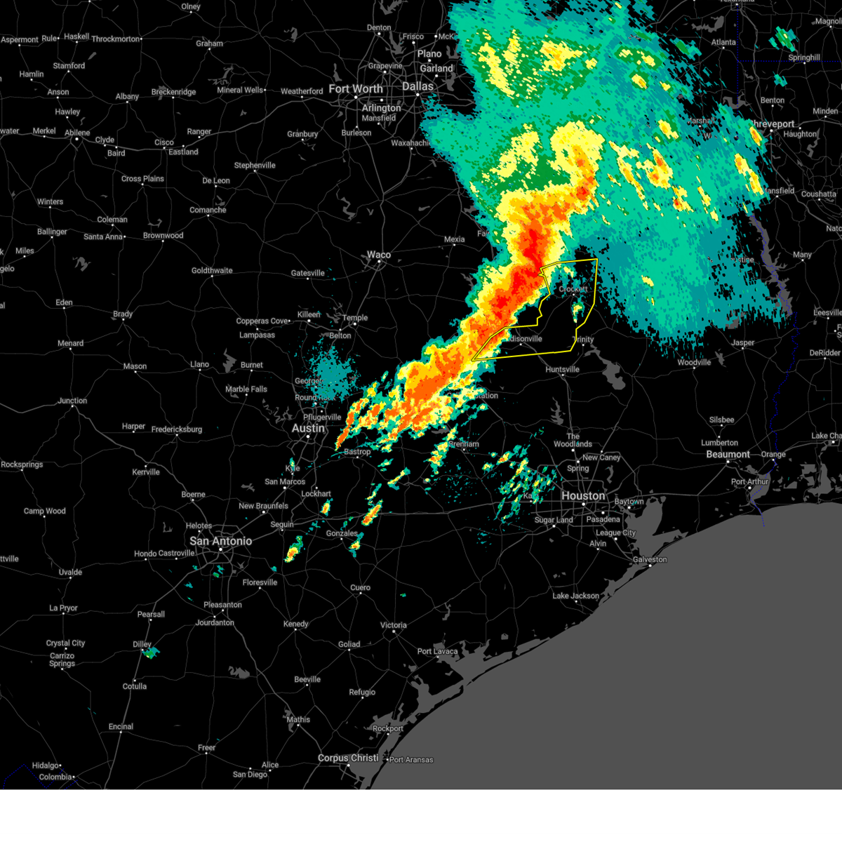
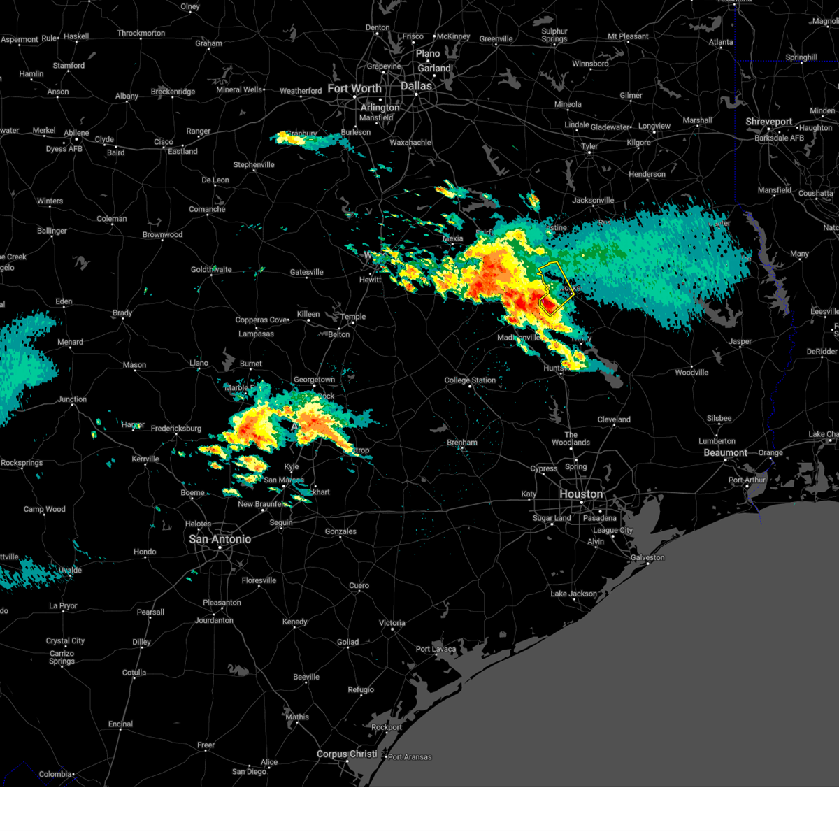
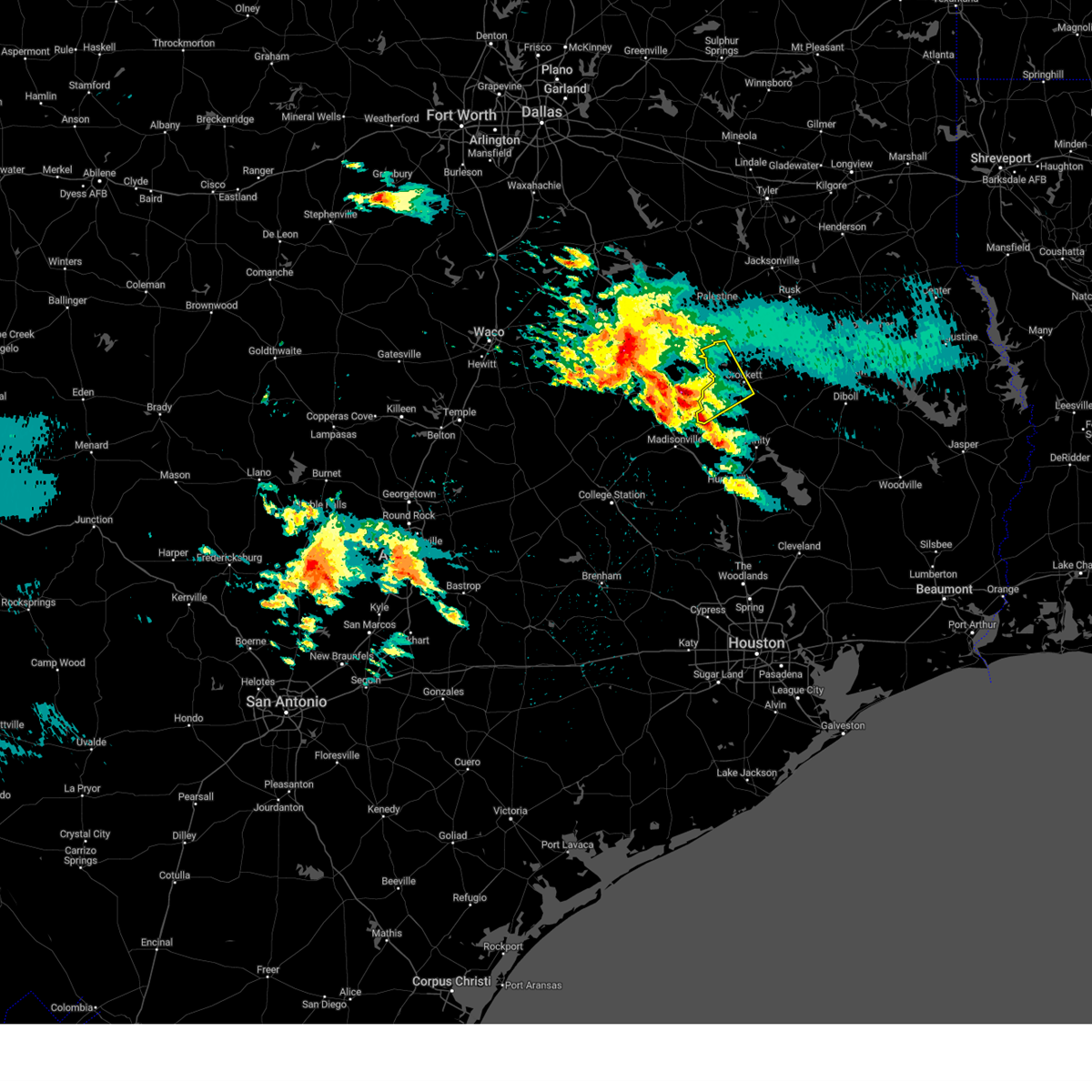
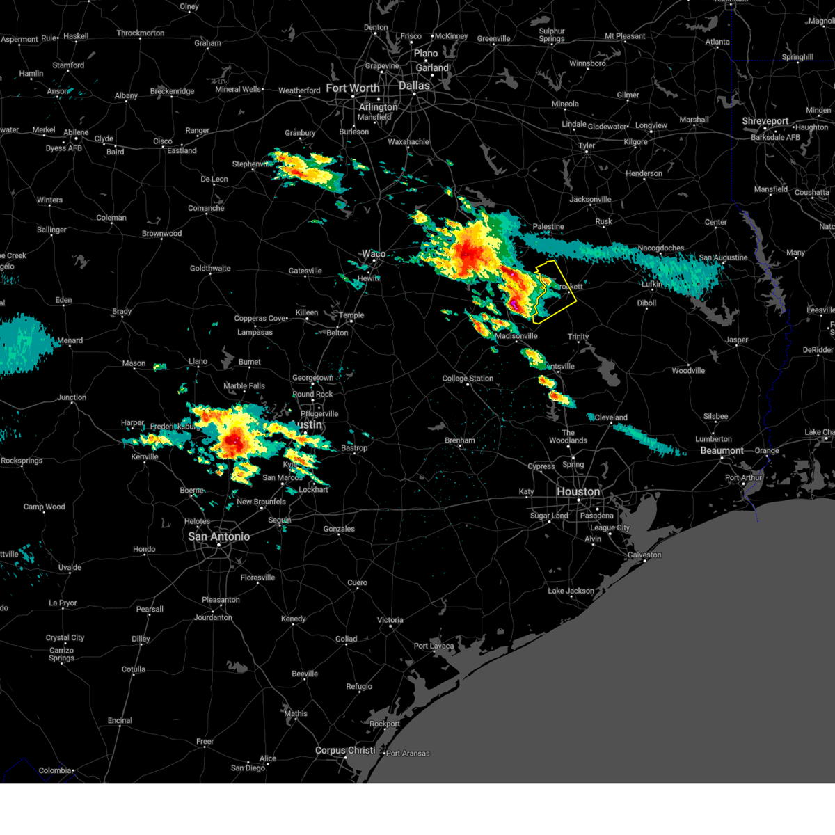
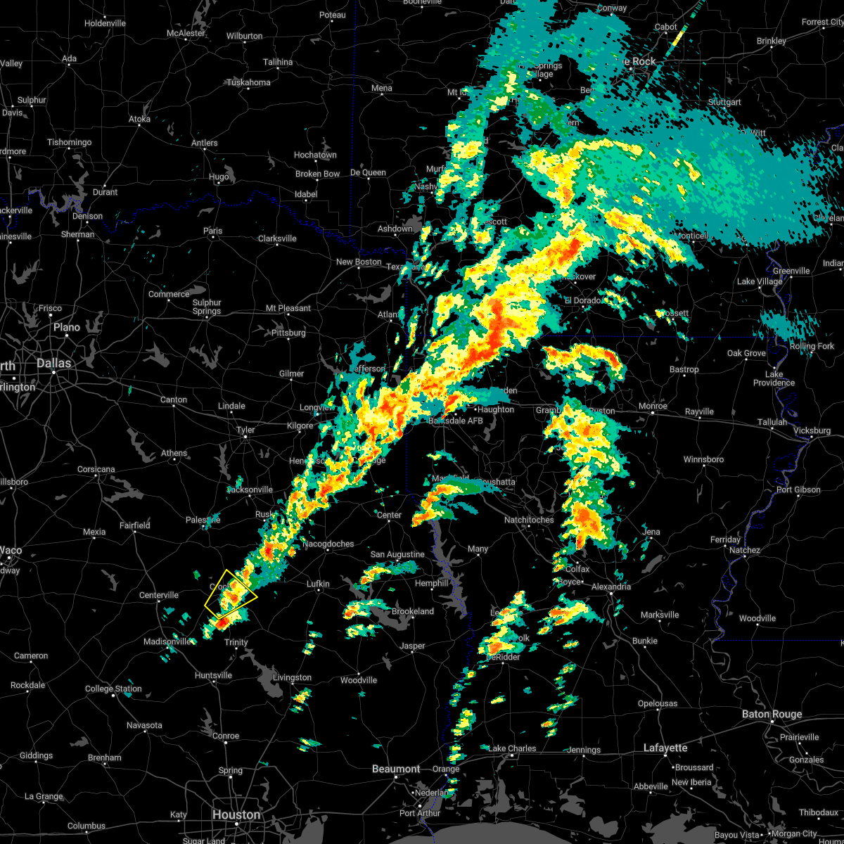
The Top Recent Hail Date for Crockett, TX is Sunday, June 1, 2025 (7th out of 59)
Hail and Wind Damage Spotted near Crockett, TX
| Date / Time | Report Details |
|---|---|
| 6/1/2025 1:52 PM CDT |
 Svrhgx the national weather service in league city has issued a * severe thunderstorm warning for, west central trinity county in southeastern texas, central houston county in southeastern texas, northeastern walker county in southeastern texas, * until 215 pm cdt. * at 151 pm cdt, a severe thunderstorm was located near crockett, moving southeast at 20 mph (radar indicated). Hazards include 60 mph wind gusts and quarter size hail. Hail damage to vehicles is expected. Expect wind damage to roofs, siding, and trees. Svrhgx the national weather service in league city has issued a * severe thunderstorm warning for, west central trinity county in southeastern texas, central houston county in southeastern texas, northeastern walker county in southeastern texas, * until 215 pm cdt. * at 151 pm cdt, a severe thunderstorm was located near crockett, moving southeast at 20 mph (radar indicated). Hazards include 60 mph wind gusts and quarter size hail. Hail damage to vehicles is expected. Expect wind damage to roofs, siding, and trees.
|
| 5/6/2025 3:14 PM CDT | Svrhgx the national weather service in league city has issued a * severe thunderstorm warning for, northern trinity county in southeastern texas, central houston county in southeastern texas, * until 345 pm cdt. * at 313 pm cdt, severe thunderstorms were located along a line extending from near kennard to 11 miles southeast of crockett to near lovelady, moving east at 50 mph (radar indicated). Hazards include 60 mph wind gusts and quarter size hail. Hail damage to vehicles is expected. Expect wind damage to roofs, siding, and trees. |
| 5/6/2025 2:41 PM CDT |
 Svrhgx the national weather service in league city has issued a * severe thunderstorm warning for, west central trinity county in southeastern texas, southwestern houston county in southeastern texas, northeastern madison county in southeastern texas, * until 315 pm cdt. * at 241 pm cdt, a severe thunderstorm was located 7 miles southwest of austonio, moving east at 60 mph (radar indicated). Hazards include 60 mph wind gusts and penny size hail. expect damage to roofs, siding, and trees Svrhgx the national weather service in league city has issued a * severe thunderstorm warning for, west central trinity county in southeastern texas, southwestern houston county in southeastern texas, northeastern madison county in southeastern texas, * until 315 pm cdt. * at 241 pm cdt, a severe thunderstorm was located 7 miles southwest of austonio, moving east at 60 mph (radar indicated). Hazards include 60 mph wind gusts and penny size hail. expect damage to roofs, siding, and trees
|
| 5/6/2025 2:37 PM CDT | At 237 pm cdt, severe thunderstorms were located along a line extending from near forest to near kennard to near lovelady, moving east at 40 mph (radar indicated). Hazards include 60 mph wind gusts and penny size hail. Expect damage to roofs, siding, and trees. Locations impacted include, crockett, kennard, latexo, and weches. |
| 5/6/2025 2:37 PM CDT | the severe thunderstorm warning has been cancelled and is no longer in effect |
| 5/6/2025 2:21 PM CDT |
 Svrhgx the national weather service in league city has issued a * severe thunderstorm warning for, central trinity county in southeastern texas, houston county in southeastern texas, northeastern walker county in southeastern texas, * until 245 pm cdt. * at 221 pm cdt, severe thunderstorms were located along a line extending from 8 miles west of morrill to 6 miles east of crockett to near austonio, moving east at 40 mph (radar indicated). Hazards include 60 mph wind gusts and penny size hail. expect damage to roofs, siding, and trees Svrhgx the national weather service in league city has issued a * severe thunderstorm warning for, central trinity county in southeastern texas, houston county in southeastern texas, northeastern walker county in southeastern texas, * until 245 pm cdt. * at 221 pm cdt, severe thunderstorms were located along a line extending from 8 miles west of morrill to 6 miles east of crockett to near austonio, moving east at 40 mph (radar indicated). Hazards include 60 mph wind gusts and penny size hail. expect damage to roofs, siding, and trees
|
| 5/6/2025 2:09 PM CDT | the severe thunderstorm warning has been cancelled and is no longer in effect |
| 5/6/2025 2:09 PM CDT | At 209 pm cdt, severe thunderstorms were located along a line extending from near elkhart to near austonio to near madisonville, moving east at 35 mph (radar indicated). Hazards include 60 mph wind gusts and penny size hail. Expect damage to roofs, siding, and trees. Locations impacted include, crockett, austonio, grapeland, lovelady, and latexo. |
| 5/6/2025 1:44 PM CDT |
 Svrhgx the national weather service in league city has issued a * severe thunderstorm warning for, northeastern brazos county in southeastern texas, houston county in southeastern texas, madison county in southeastern texas, northwestern walker county in southeastern texas, * until 230 pm cdt. * at 144 pm cdt, severe thunderstorms were located along a line extending from 15 miles southwest of elkhart to near fort boggy state park to 11 miles northeast of kurten, moving east at 35 mph (radar indicated). Hazards include 60 mph wind gusts and penny size hail. expect damage to roofs, siding, and trees Svrhgx the national weather service in league city has issued a * severe thunderstorm warning for, northeastern brazos county in southeastern texas, houston county in southeastern texas, madison county in southeastern texas, northwestern walker county in southeastern texas, * until 230 pm cdt. * at 144 pm cdt, severe thunderstorms were located along a line extending from 15 miles southwest of elkhart to near fort boggy state park to 11 miles northeast of kurten, moving east at 35 mph (radar indicated). Hazards include 60 mph wind gusts and penny size hail. expect damage to roofs, siding, and trees
|
| 5/6/2025 1:24 PM CDT |
 Torhgx the national weather service in league city has issued a * tornado warning for, northwestern houston county in southeastern texas, * until 200 pm cdt. * at 123 pm cdt, a severe thunderstorm capable of producing a tornado was located 7 miles north of centerville, or 24 miles northwest of austonio, moving northeast at 45 mph (radar indicated rotation). Hazards include tornado. Flying debris will be dangerous to those caught without shelter. mobile homes will be damaged or destroyed. damage to roofs, windows, and vehicles will occur. tree damage is likely. This dangerous storm will be near, grapeland around 150 pm cdt. Torhgx the national weather service in league city has issued a * tornado warning for, northwestern houston county in southeastern texas, * until 200 pm cdt. * at 123 pm cdt, a severe thunderstorm capable of producing a tornado was located 7 miles north of centerville, or 24 miles northwest of austonio, moving northeast at 45 mph (radar indicated rotation). Hazards include tornado. Flying debris will be dangerous to those caught without shelter. mobile homes will be damaged or destroyed. damage to roofs, windows, and vehicles will occur. tree damage is likely. This dangerous storm will be near, grapeland around 150 pm cdt.
|
| 4/30/2025 10:33 PM CDT |
 Svrhgx the national weather service in league city has issued a * severe thunderstorm warning for, northern trinity county in southeastern texas, central houston county in southeastern texas, * until 1115 pm cdt. * at 1032 pm cdt, a severe thunderstorm was located near crockett, moving east at 45 mph (radar indicated). Hazards include 60 mph wind gusts and quarter size hail. Hail damage to vehicles is expected. Expect wind damage to roofs, siding, and trees. Svrhgx the national weather service in league city has issued a * severe thunderstorm warning for, northern trinity county in southeastern texas, central houston county in southeastern texas, * until 1115 pm cdt. * at 1032 pm cdt, a severe thunderstorm was located near crockett, moving east at 45 mph (radar indicated). Hazards include 60 mph wind gusts and quarter size hail. Hail damage to vehicles is expected. Expect wind damage to roofs, siding, and trees.
|
| 4/24/2025 5:22 PM CDT |
 The storm which prompted the warning has weakened below severe limits, and has exited the warned area. therefore, the warning will be allowed to expire. a severe thunderstorm watch remains in effect until 800 pm cdt for southeastern texas. The storm which prompted the warning has weakened below severe limits, and has exited the warned area. therefore, the warning will be allowed to expire. a severe thunderstorm watch remains in effect until 800 pm cdt for southeastern texas.
|
| 4/24/2025 4:55 PM CDT |
 Svrhgx the national weather service in league city has issued a * severe thunderstorm warning for, southwestern houston county in southeastern texas, * until 530 pm cdt. * at 455 pm cdt, a severe thunderstorm was located near crockett, moving east at around 25 mph (radar indicated). Hazards include 60 mph wind gusts and penny size hail. expect damage to roofs, siding, and trees Svrhgx the national weather service in league city has issued a * severe thunderstorm warning for, southwestern houston county in southeastern texas, * until 530 pm cdt. * at 455 pm cdt, a severe thunderstorm was located near crockett, moving east at around 25 mph (radar indicated). Hazards include 60 mph wind gusts and penny size hail. expect damage to roofs, siding, and trees
|
| 3/14/2025 8:45 PM CDT |
 the severe thunderstorm warning has been cancelled and is no longer in effect the severe thunderstorm warning has been cancelled and is no longer in effect
|
| 3/14/2025 8:25 PM CDT |
 Svrhgx the national weather service in league city has issued a * severe thunderstorm warning for, northwestern houston county in southeastern texas, * until 900 pm cdt. * at 824 pm cdt, a severe thunderstorm was located 9 miles north of austonio, moving east at 30 mph (radar indicated). Hazards include 60 mph wind gusts and quarter size hail. Hail damage to vehicles is expected. Expect wind damage to roofs, siding, and trees. Svrhgx the national weather service in league city has issued a * severe thunderstorm warning for, northwestern houston county in southeastern texas, * until 900 pm cdt. * at 824 pm cdt, a severe thunderstorm was located 9 miles north of austonio, moving east at 30 mph (radar indicated). Hazards include 60 mph wind gusts and quarter size hail. Hail damage to vehicles is expected. Expect wind damage to roofs, siding, and trees.
|
| 3/4/2025 8:26 AM CST |
 Svrhgx the national weather service in league city has issued a * severe thunderstorm warning for, trinity county in southeastern texas, northwestern san jacinto county in southeastern texas, central houston county in southeastern texas, northeastern madison county in southeastern texas, northwestern polk county in southeastern texas, central walker county in southeastern texas, * until 915 am cst. * at 824 am cst, a cluster of strong and severe thunderstorms was located 7 miles northwest of huntsville, moving northeast at 60 mph (radar indicated). Hazards include 60 mph wind gusts. expect damage to roofs, siding, and trees Svrhgx the national weather service in league city has issued a * severe thunderstorm warning for, trinity county in southeastern texas, northwestern san jacinto county in southeastern texas, central houston county in southeastern texas, northeastern madison county in southeastern texas, northwestern polk county in southeastern texas, central walker county in southeastern texas, * until 915 am cst. * at 824 am cst, a cluster of strong and severe thunderstorms was located 7 miles northwest of huntsville, moving northeast at 60 mph (radar indicated). Hazards include 60 mph wind gusts. expect damage to roofs, siding, and trees
|
| 12/28/2024 1:35 PM CST | Building damage along east loop 30 in houston county TX, 0.9 miles W of Crockett, TX |
| 12/28/2024 1:31 PM CST | Svrhgx the national weather service in league city has issued a * severe thunderstorm warning for, trinity county in southeastern texas, houston county in southeastern texas, eastern madison county in southeastern texas, northeastern walker county in southeastern texas, * until 215 pm cst. * at 130 pm cst, a cluster of storm to severe thunderstorms was centered near crockett, moving northeast at 40 mph (radar indicated). Hazards include 60 mph wind gusts and quarter size hail. Hail damage to vehicles is expected. Expect wind damage to roofs, siding, and trees. |
| 5/31/2024 6:14 AM CDT |
 At 613 am cdt, severe thunderstorms were located along a line extending from 7 miles northeast of huntsville to 7 miles southeast of columbus, moving southeast at 40 mph (radar indicated). Hazards include 60 mph wind gusts and penny size hail. Expect damage to roofs, siding, and trees. Locations impacted include, huntsville, brenham, tomball, navasota, crockett, sealy, hempstead, prairie view, bellville, columbus, pinehurst, austonio, washington, shelby, hockley, trinity, waller, grapeland, magnolia, and new waverly. At 613 am cdt, severe thunderstorms were located along a line extending from 7 miles northeast of huntsville to 7 miles southeast of columbus, moving southeast at 40 mph (radar indicated). Hazards include 60 mph wind gusts and penny size hail. Expect damage to roofs, siding, and trees. Locations impacted include, huntsville, brenham, tomball, navasota, crockett, sealy, hempstead, prairie view, bellville, columbus, pinehurst, austonio, washington, shelby, hockley, trinity, waller, grapeland, magnolia, and new waverly.
|
| 5/31/2024 5:58 AM CDT |
 Svrhgx the national weather service in league city has issued a * severe thunderstorm warning for, southwestern trinity county in southeastern texas, northeastern colorado county in southeastern texas, austin county in southeastern texas, grimes county in southeastern texas, southeastern brazos county in southeastern texas, washington county in southeastern texas, western montgomery county in southeastern texas, houston county in southeastern texas, eastern madison county in southeastern texas, waller county in southeastern texas, walker county in southeastern texas, northwestern harris county in southeastern texas, * until 645 am cdt. * at 557 am cdt, severe thunderstorms were located along a line extending from 7 miles west of riverside to 6 miles north of columbus, moving southeast at around 40 mph (radar indicated). Hazards include 60 mph wind gusts and penny size hail. expect damage to roofs, siding, and trees Svrhgx the national weather service in league city has issued a * severe thunderstorm warning for, southwestern trinity county in southeastern texas, northeastern colorado county in southeastern texas, austin county in southeastern texas, grimes county in southeastern texas, southeastern brazos county in southeastern texas, washington county in southeastern texas, western montgomery county in southeastern texas, houston county in southeastern texas, eastern madison county in southeastern texas, waller county in southeastern texas, walker county in southeastern texas, northwestern harris county in southeastern texas, * until 645 am cdt. * at 557 am cdt, severe thunderstorms were located along a line extending from 7 miles west of riverside to 6 miles north of columbus, moving southeast at around 40 mph (radar indicated). Hazards include 60 mph wind gusts and penny size hail. expect damage to roofs, siding, and trees
|
| 5/31/2024 5:36 AM CDT |
 Svrhgx the national weather service in league city has issued a * severe thunderstorm warning for, grimes county in southeastern texas, southeastern brazos county in southeastern texas, northwestern montgomery county in southeastern texas, western houston county in southeastern texas, madison county in southeastern texas, western walker county in southeastern texas, * until 600 am cdt. * at 535 am cdt, severe thunderstorms were located along a line extending from 8 miles southwest of elkhart to near navasota, moving east at 40 mph (radar indicated). Hazards include 60 mph wind gusts and penny size hail. expect damage to roofs, siding, and trees Svrhgx the national weather service in league city has issued a * severe thunderstorm warning for, grimes county in southeastern texas, southeastern brazos county in southeastern texas, northwestern montgomery county in southeastern texas, western houston county in southeastern texas, madison county in southeastern texas, western walker county in southeastern texas, * until 600 am cdt. * at 535 am cdt, severe thunderstorms were located along a line extending from 8 miles southwest of elkhart to near navasota, moving east at 40 mph (radar indicated). Hazards include 60 mph wind gusts and penny size hail. expect damage to roofs, siding, and trees
|
| 5/30/2024 6:45 PM CDT | Txdot reported trees down in houston county on multiple roads. fm2110... fm1733... sh 7w... fm227 w... and fm254 in houston county TX, 7.7 miles NE of Crockett, TX |
| 5/30/2024 6:21 PM CDT |
 Svrhgx the national weather service in league city has issued a * severe thunderstorm warning for, west central trinity county in southeastern texas, southwestern houston county in southeastern texas, northeastern madison county in southeastern texas, * until 645 pm cdt. * at 620 pm cdt, a severe thunderstorm was located near austonio, moving east at 40 mph (radar indicated). Hazards include quarter size hail. damage to vehicles is expected Svrhgx the national weather service in league city has issued a * severe thunderstorm warning for, west central trinity county in southeastern texas, southwestern houston county in southeastern texas, northeastern madison county in southeastern texas, * until 645 pm cdt. * at 620 pm cdt, a severe thunderstorm was located near austonio, moving east at 40 mph (radar indicated). Hazards include quarter size hail. damage to vehicles is expected
|
| 5/28/2024 11:52 AM CDT |
 The storms which prompted the warning have weakened below severe limits, and have exited the warned area. therefore, the warning will be allowed to expire. however, small hail is still possible with these thunderstorms. a severe thunderstorm watch remains in effect until 600 pm cdt for southeastern texas. remember, a severe thunderstorm warning still remains in effect for eastern madison and southwestern houston counties. The storms which prompted the warning have weakened below severe limits, and have exited the warned area. therefore, the warning will be allowed to expire. however, small hail is still possible with these thunderstorms. a severe thunderstorm watch remains in effect until 600 pm cdt for southeastern texas. remember, a severe thunderstorm warning still remains in effect for eastern madison and southwestern houston counties.
|
| 5/28/2024 11:43 AM CDT | Ham radio operator reported widespread tree damage across houston county. time estimated based on rada in houston county TX, 0.3 miles ENE of Crockett, TX |
| 5/28/2024 10:57 AM CDT |
 Svrhgx the national weather service in league city has issued a * severe thunderstorm warning for, houston county in southeastern texas, northeastern madison county in southeastern texas, * until noon cdt. * at 1057 am cdt, a cluster of severe thunderstorms were located along a line extending from near palestine to near buffalo, moving southeast at 35 mph (radar indicated). Hazards include 60 mph wind gusts and quarter size hail. Hail damage to vehicles is expected. Expect wind damage to roofs, siding, and trees. Svrhgx the national weather service in league city has issued a * severe thunderstorm warning for, houston county in southeastern texas, northeastern madison county in southeastern texas, * until noon cdt. * at 1057 am cdt, a cluster of severe thunderstorms were located along a line extending from near palestine to near buffalo, moving southeast at 35 mph (radar indicated). Hazards include 60 mph wind gusts and quarter size hail. Hail damage to vehicles is expected. Expect wind damage to roofs, siding, and trees.
|
| 5/22/2024 9:35 PM CDT |
 The storms which prompted the warning have weakened below severe limits, and no longer pose an immediate threat to life or property. therefore, the warning will be allowed to expire. however, gusty winds are still possible with these thunderstorms. a tornado watch remains in effect until midnight cdt for southeastern texas. to report severe weather, contact your nearest law enforcement agency. they will relay your report to the national weather service league city. The storms which prompted the warning have weakened below severe limits, and no longer pose an immediate threat to life or property. therefore, the warning will be allowed to expire. however, gusty winds are still possible with these thunderstorms. a tornado watch remains in effect until midnight cdt for southeastern texas. to report severe weather, contact your nearest law enforcement agency. they will relay your report to the national weather service league city.
|
| 5/22/2024 8:57 PM CDT |
 Svrhgx the national weather service in league city has issued a * severe thunderstorm warning for, trinity county in southeastern texas, houston county in southeastern texas, northeastern madison county in southeastern texas, northeastern walker county in southeastern texas, * until 945 pm cdt. * at 856 pm cdt, severe thunderstorms were located along a line extending from 11 miles south of maydelle to 8 miles northwest of huntsville, moving east at 45 mph (radar indicated). Hazards include 60 mph wind gusts and quarter size hail. Hail damage to vehicles is expected. Expect wind damage to roofs, siding, and trees. Svrhgx the national weather service in league city has issued a * severe thunderstorm warning for, trinity county in southeastern texas, houston county in southeastern texas, northeastern madison county in southeastern texas, northeastern walker county in southeastern texas, * until 945 pm cdt. * at 856 pm cdt, severe thunderstorms were located along a line extending from 11 miles south of maydelle to 8 miles northwest of huntsville, moving east at 45 mph (radar indicated). Hazards include 60 mph wind gusts and quarter size hail. Hail damage to vehicles is expected. Expect wind damage to roofs, siding, and trees.
|
| 5/22/2024 8:30 PM CDT |
 At 829 pm cdt, severe thunderstorms were located along a line extending from 8 miles southwest of palestine to 9 miles southeast of madisonville, moving east at 45 mph (radar indicated). Hazards include 70 mph wind gusts and quarter size hail. Hail damage to vehicles is expected. expect considerable tree damage. wind damage is also likely to mobile homes, roofs, and outbuildings. Locations impacted include, northern huntsville, crockett, madisonville, austonio, trinity, grapeland, lovelady, riverside, bedias, latexo, normangee, iola, crabbs prairie, north zulch, and mound city. At 829 pm cdt, severe thunderstorms were located along a line extending from 8 miles southwest of palestine to 9 miles southeast of madisonville, moving east at 45 mph (radar indicated). Hazards include 70 mph wind gusts and quarter size hail. Hail damage to vehicles is expected. expect considerable tree damage. wind damage is also likely to mobile homes, roofs, and outbuildings. Locations impacted include, northern huntsville, crockett, madisonville, austonio, trinity, grapeland, lovelady, riverside, bedias, latexo, normangee, iola, crabbs prairie, north zulch, and mound city.
|
| 5/22/2024 8:30 PM CDT |
 the severe thunderstorm warning has been cancelled and is no longer in effect the severe thunderstorm warning has been cancelled and is no longer in effect
|
| 5/22/2024 7:58 PM CDT |
 Svrhgx the national weather service in league city has issued a * severe thunderstorm warning for, southwestern trinity county in southeastern texas, northern grimes county in southeastern texas, northeastern brazos county in southeastern texas, houston county in southeastern texas, madison county in southeastern texas, central walker county in southeastern texas, * until 900 pm cdt. * at 756 pm cdt, severe thunderstorms were located along a line extending from near fairfield to 6 miles northeast of kurten, moving east at 45 mph (radar indicated). Hazards include 70 mph wind gusts and quarter size hail. Hail damage to vehicles is expected. expect considerable tree damage. Wind damage is also likely to mobile homes, roofs, and outbuildings. Svrhgx the national weather service in league city has issued a * severe thunderstorm warning for, southwestern trinity county in southeastern texas, northern grimes county in southeastern texas, northeastern brazos county in southeastern texas, houston county in southeastern texas, madison county in southeastern texas, central walker county in southeastern texas, * until 900 pm cdt. * at 756 pm cdt, severe thunderstorms were located along a line extending from near fairfield to 6 miles northeast of kurten, moving east at 45 mph (radar indicated). Hazards include 70 mph wind gusts and quarter size hail. Hail damage to vehicles is expected. expect considerable tree damage. Wind damage is also likely to mobile homes, roofs, and outbuildings.
|
| 5/3/2024 3:52 AM CDT |
 Svrhgx the national weather service in league city has issued a * severe thunderstorm warning for, trinity county in southeastern texas, northwestern san jacinto county in southeastern texas, houston county in southeastern texas, northeastern madison county in southeastern texas, northwestern polk county in southeastern texas, northern walker county in southeastern texas, * until 430 am cdt. * at 352 am cdt, severe thunderstorms were located along a line extending from 8 miles northeast of grapeland to 13 miles west of riverside, moving east at 30 mph (radar indicated). Hazards include 60 mph wind gusts and quarter size hail. Hail damage to vehicles is expected. Expect wind damage to roofs, siding, and trees. Svrhgx the national weather service in league city has issued a * severe thunderstorm warning for, trinity county in southeastern texas, northwestern san jacinto county in southeastern texas, houston county in southeastern texas, northeastern madison county in southeastern texas, northwestern polk county in southeastern texas, northern walker county in southeastern texas, * until 430 am cdt. * at 352 am cdt, severe thunderstorms were located along a line extending from 8 miles northeast of grapeland to 13 miles west of riverside, moving east at 30 mph (radar indicated). Hazards include 60 mph wind gusts and quarter size hail. Hail damage to vehicles is expected. Expect wind damage to roofs, siding, and trees.
|
| 5/3/2024 3:15 AM CDT |
 Svrhgx the national weather service in league city has issued a * severe thunderstorm warning for, west central trinity county in southeastern texas, houston county in southeastern texas, madison county in southeastern texas, northern walker county in southeastern texas, * until 400 am cdt. * at 314 am cdt, severe thunderstorms were located along a line extending from 8 miles west of elkhart to near madisonville, moving east at 35 mph (radar indicated). Hazards include 60 mph wind gusts and quarter size hail. Hail damage to vehicles is expected. Expect wind damage to roofs, siding, and trees. Svrhgx the national weather service in league city has issued a * severe thunderstorm warning for, west central trinity county in southeastern texas, houston county in southeastern texas, madison county in southeastern texas, northern walker county in southeastern texas, * until 400 am cdt. * at 314 am cdt, severe thunderstorms were located along a line extending from 8 miles west of elkhart to near madisonville, moving east at 35 mph (radar indicated). Hazards include 60 mph wind gusts and quarter size hail. Hail damage to vehicles is expected. Expect wind damage to roofs, siding, and trees.
|
| 5/1/2024 9:11 PM CDT |
 the severe thunderstorm warning has been cancelled and is no longer in effect the severe thunderstorm warning has been cancelled and is no longer in effect
|
| 5/1/2024 8:42 PM CDT |
 Svrhgx the national weather service in league city has issued a * severe thunderstorm warning for, southwestern houston county in southeastern texas, * until 930 pm cdt. * at 841 pm cdt, a severe thunderstorm was located 9 miles south of austonio, moving northeast at 30 mph (radar indicated). Hazards include quarter size hail. damage to vehicles is expected Svrhgx the national weather service in league city has issued a * severe thunderstorm warning for, southwestern houston county in southeastern texas, * until 930 pm cdt. * at 841 pm cdt, a severe thunderstorm was located 9 miles south of austonio, moving northeast at 30 mph (radar indicated). Hazards include quarter size hail. damage to vehicles is expected
|
| 5/1/2024 8:14 PM CDT |
 The storm which prompted the warning has weakened below severe limits, and no longer poses an immediate threat to life or property. therefore, the warning will be allowed to expire. however, heavy rain is still possible with this thunderstorm. a severe thunderstorm watch remains in effect until 200 am cdt for southeastern texas. The storm which prompted the warning has weakened below severe limits, and no longer poses an immediate threat to life or property. therefore, the warning will be allowed to expire. however, heavy rain is still possible with this thunderstorm. a severe thunderstorm watch remains in effect until 200 am cdt for southeastern texas.
|
| 5/1/2024 7:58 PM CDT |
 At 758 pm cdt, a severe thunderstorm was located near austonio, moving northeast at 30 mph (radar indicated). Hazards include quarter size hail. Damage to vehicles is expected. Locations impacted include, crockett, austonio, and latexo. At 758 pm cdt, a severe thunderstorm was located near austonio, moving northeast at 30 mph (radar indicated). Hazards include quarter size hail. Damage to vehicles is expected. Locations impacted include, crockett, austonio, and latexo.
|
| 5/1/2024 7:42 PM CDT |
 At 741 pm cdt, a severe thunderstorm was located near austonio, moving northeast at 35 mph (radar indicated). Hazards include quarter size hail. Damage to vehicles is expected. Locations impacted include, crockett, austonio, and latexo. At 741 pm cdt, a severe thunderstorm was located near austonio, moving northeast at 35 mph (radar indicated). Hazards include quarter size hail. Damage to vehicles is expected. Locations impacted include, crockett, austonio, and latexo.
|
| 5/1/2024 7:10 PM CDT |
 Svrhgx the national weather service in league city has issued a * severe thunderstorm warning for, northwestern houston county in southeastern texas, * until 815 pm cdt. * at 710 pm cdt, a severe thunderstorm was located near centerville, or 14 miles west of austonio, moving northeast at 20 mph (trained weather spotters). Hazards include quarter size hail. damage to vehicles is expected Svrhgx the national weather service in league city has issued a * severe thunderstorm warning for, northwestern houston county in southeastern texas, * until 815 pm cdt. * at 710 pm cdt, a severe thunderstorm was located near centerville, or 14 miles west of austonio, moving northeast at 20 mph (trained weather spotters). Hazards include quarter size hail. damage to vehicles is expected
|
| 4/28/2024 6:57 PM CDT |
 Svrhgx the national weather service in league city has issued a * severe thunderstorm warning for, northwestern trinity county in southeastern texas, central houston county in southeastern texas, * until 745 pm cdt. * at 657 pm cdt, a severe thunderstorm was located near crockett, moving east at 25 mph (radar indicated). Hazards include 60 mph wind gusts. expect damage to roofs, siding, and trees Svrhgx the national weather service in league city has issued a * severe thunderstorm warning for, northwestern trinity county in southeastern texas, central houston county in southeastern texas, * until 745 pm cdt. * at 657 pm cdt, a severe thunderstorm was located near crockett, moving east at 25 mph (radar indicated). Hazards include 60 mph wind gusts. expect damage to roofs, siding, and trees
|
| 4/28/2024 6:51 PM CDT |
 At 651 pm cdt, a severe thunderstorm capable of producing a tornado was located near lovelady, or 8 miles south of crockett, moving east at 30 mph (radar indicated rotation). Hazards include tornado. Flying debris will be dangerous to those caught without shelter. mobile homes will be damaged or destroyed. damage to roofs, windows, and vehicles will occur. tree damage is likely. This dangerous storm will be near, crockett around 655 pm cdt. At 651 pm cdt, a severe thunderstorm capable of producing a tornado was located near lovelady, or 8 miles south of crockett, moving east at 30 mph (radar indicated rotation). Hazards include tornado. Flying debris will be dangerous to those caught without shelter. mobile homes will be damaged or destroyed. damage to roofs, windows, and vehicles will occur. tree damage is likely. This dangerous storm will be near, crockett around 655 pm cdt.
|
| 4/28/2024 6:33 PM CDT |
 the tornado warning has been cancelled and is no longer in effect the tornado warning has been cancelled and is no longer in effect
|
| 4/28/2024 6:33 PM CDT |
 At 632 pm cdt, a severe thunderstorm capable of producing a tornado was located near austonio, moving east at 30 mph (radar indicated rotation). Hazards include tornado and ping pong ball size hail. Flying debris will be dangerous to those caught without shelter. mobile homes will be damaged or destroyed. damage to roofs, windows, and vehicles will occur. tree damage is likely. this dangerous storm will be near, lovelady around 635 pm cdt. Crockett around 645 pm cdt. At 632 pm cdt, a severe thunderstorm capable of producing a tornado was located near austonio, moving east at 30 mph (radar indicated rotation). Hazards include tornado and ping pong ball size hail. Flying debris will be dangerous to those caught without shelter. mobile homes will be damaged or destroyed. damage to roofs, windows, and vehicles will occur. tree damage is likely. this dangerous storm will be near, lovelady around 635 pm cdt. Crockett around 645 pm cdt.
|
| 4/28/2024 6:21 PM CDT |
 At 620 pm cdt, a severe thunderstorm capable of producing a tornado was located near austonio, moving east at 30 mph (radar indicated rotation). Hazards include tornado and tennis ball size hail. Flying debris will be dangerous to those caught without shelter. mobile homes will be damaged or destroyed. damage to roofs, windows, and vehicles will occur. tree damage is likely. this dangerous storm will be near, austonio around 625 pm cdt. lovelady around 635 pm cdt. Crockett around 645 pm cdt. At 620 pm cdt, a severe thunderstorm capable of producing a tornado was located near austonio, moving east at 30 mph (radar indicated rotation). Hazards include tornado and tennis ball size hail. Flying debris will be dangerous to those caught without shelter. mobile homes will be damaged or destroyed. damage to roofs, windows, and vehicles will occur. tree damage is likely. this dangerous storm will be near, austonio around 625 pm cdt. lovelady around 635 pm cdt. Crockett around 645 pm cdt.
|
| 4/28/2024 6:15 PM CDT | Golf Ball sized hail reported 15.7 miles ENE of Crockett, TX, golf ball sized hail was observed along cr 3180. |
| 4/28/2024 6:14 PM CDT |
 Torhgx the national weather service in league city has issued a * tornado warning for, northwestern houston county in southeastern texas, north central madison county in southeastern texas, * until 700 pm cdt. * at 613 pm cdt, a severe thunderstorm capable of producing a tornado was located 7 miles southwest of austonio, moving east at 30 mph (radar indicated rotation). Hazards include tornado and golf ball size hail. Flying debris will be dangerous to those caught without shelter. mobile homes will be damaged or destroyed. damage to roofs, windows, and vehicles will occur. tree damage is likely. this dangerous storm will be near, austonio around 620 pm cdt. lovelady around 635 pm cdt. Crockett around 645 pm cdt. Torhgx the national weather service in league city has issued a * tornado warning for, northwestern houston county in southeastern texas, north central madison county in southeastern texas, * until 700 pm cdt. * at 613 pm cdt, a severe thunderstorm capable of producing a tornado was located 7 miles southwest of austonio, moving east at 30 mph (radar indicated rotation). Hazards include tornado and golf ball size hail. Flying debris will be dangerous to those caught without shelter. mobile homes will be damaged or destroyed. damage to roofs, windows, and vehicles will occur. tree damage is likely. this dangerous storm will be near, austonio around 620 pm cdt. lovelady around 635 pm cdt. Crockett around 645 pm cdt.
|
| 6/10/2023 6:57 PM CDT |
 The severe thunderstorm warning for houston county will expire at 700 pm cdt, the storms which prompted the warning have weakened below severe limits, and no longer pose an immediate threat to life or property. therefore, the warning will be allowed to expire. however small hail, gusty winds and heavy rain are still possible with these thunderstorms. a severe thunderstorm watch remains in effect until 1000 pm cdt for southeastern texas. The severe thunderstorm warning for houston county will expire at 700 pm cdt, the storms which prompted the warning have weakened below severe limits, and no longer pose an immediate threat to life or property. therefore, the warning will be allowed to expire. however small hail, gusty winds and heavy rain are still possible with these thunderstorms. a severe thunderstorm watch remains in effect until 1000 pm cdt for southeastern texas.
|
| 6/10/2023 6:29 PM CDT |
 At 628 pm cdt, severe thunderstorms were located along a line extending from 13 miles south of maydelle to near grapeland to 12 miles north of austonio, moving southeast at 30 mph (radar indicated). Hazards include 60 mph wind gusts and penny size hail. expect damage to roofs, siding, and trees At 628 pm cdt, severe thunderstorms were located along a line extending from 13 miles south of maydelle to near grapeland to 12 miles north of austonio, moving southeast at 30 mph (radar indicated). Hazards include 60 mph wind gusts and penny size hail. expect damage to roofs, siding, and trees
|
| 6/10/2023 6:13 PM CDT |
 At 612 pm cdt, severe thunderstorms were located along a line extending from 9 miles east of elkhart to near grapeland to 14 miles west of latexo, moving east at 35 mph (radar indicated. at 555 pm cdt, a gust of 63 mph was reported in palestine). Hazards include 60 mph wind gusts and quarter size hail. Hail damage to vehicles is expected. expect wind damage to roofs, siding, and trees. locations impacted include, crockett, grapeland, latexo, weches and mound city. hail threat, radar indicated max hail size, 1. 00 in wind threat, observed max wind gust, 60 mph. At 612 pm cdt, severe thunderstorms were located along a line extending from 9 miles east of elkhart to near grapeland to 14 miles west of latexo, moving east at 35 mph (radar indicated. at 555 pm cdt, a gust of 63 mph was reported in palestine). Hazards include 60 mph wind gusts and quarter size hail. Hail damage to vehicles is expected. expect wind damage to roofs, siding, and trees. locations impacted include, crockett, grapeland, latexo, weches and mound city. hail threat, radar indicated max hail size, 1. 00 in wind threat, observed max wind gust, 60 mph.
|
| 6/10/2023 5:50 PM CDT |
 At 550 pm cdt, severe thunderstorms were located along a line extending from near palestine to 6 miles west of elkhart to 12 miles northeast of buffalo, moving southeast at 35 mph (radar indicated). Hazards include 60 mph wind gusts and half dollar size hail. Hail damage to vehicles is expected. Expect wind damage to roofs, siding, and trees. At 550 pm cdt, severe thunderstorms were located along a line extending from near palestine to 6 miles west of elkhart to 12 miles northeast of buffalo, moving southeast at 35 mph (radar indicated). Hazards include 60 mph wind gusts and half dollar size hail. Hail damage to vehicles is expected. Expect wind damage to roofs, siding, and trees.
|
| 6/10/2023 5:17 PM CDT |
 At 517 pm cdt, a severe thunderstorm was located 7 miles southeast of austonio, moving northeast at 20 mph (radar indicated). Hazards include 60 mph wind gusts and quarter size hail. Hail damage to vehicles is expected. expect wind damage to roofs, siding, and trees. locations impacted include, crockett and lovelady. hail threat, radar indicated max hail size, 1. 00 in wind threat, radar indicated max wind gust, 60 mph. At 517 pm cdt, a severe thunderstorm was located 7 miles southeast of austonio, moving northeast at 20 mph (radar indicated). Hazards include 60 mph wind gusts and quarter size hail. Hail damage to vehicles is expected. expect wind damage to roofs, siding, and trees. locations impacted include, crockett and lovelady. hail threat, radar indicated max hail size, 1. 00 in wind threat, radar indicated max wind gust, 60 mph.
|
| 6/10/2023 5:01 PM CDT |
 At 500 pm cdt, a severe thunderstorm was located 9 miles south of austonio, moving northeast at 20 mph (radar indicated). Hazards include 60 mph wind gusts and quarter size hail. Hail damage to vehicles is expected. Expect wind damage to roofs, siding, and trees. At 500 pm cdt, a severe thunderstorm was located 9 miles south of austonio, moving northeast at 20 mph (radar indicated). Hazards include 60 mph wind gusts and quarter size hail. Hail damage to vehicles is expected. Expect wind damage to roofs, siding, and trees.
|
| 4/26/2023 10:01 PM CDT |
 At 1000 pm cdt, a severe thunderstorm was located near austonio, moving east at 45 mph (radar indicated. at 950 pm cdt, quarter sized hail was reported five miles east northeast of madisonville). Hazards include ping pong ball size hail and 60 mph wind gusts. People and animals outdoors will be injured. expect hail damage to roofs, siding, windows, and vehicles. expect wind damage to roofs, siding, and trees. locations impacted include, crockett, austonio and lovelady. hail threat, radar indicated max hail size, 1. 50 in wind threat, radar indicated max wind gust, 60 mph. At 1000 pm cdt, a severe thunderstorm was located near austonio, moving east at 45 mph (radar indicated. at 950 pm cdt, quarter sized hail was reported five miles east northeast of madisonville). Hazards include ping pong ball size hail and 60 mph wind gusts. People and animals outdoors will be injured. expect hail damage to roofs, siding, windows, and vehicles. expect wind damage to roofs, siding, and trees. locations impacted include, crockett, austonio and lovelady. hail threat, radar indicated max hail size, 1. 50 in wind threat, radar indicated max wind gust, 60 mph.
|
| 4/26/2023 9:47 PM CDT |
 At 946 pm cdt, a severe thunderstorm was located 10 miles northeast of madisonville, moving east at 40 mph (radar indicated). Hazards include 60 mph wind gusts and quarter size hail. Hail damage to vehicles is expected. Expect wind damage to roofs, siding, and trees. At 946 pm cdt, a severe thunderstorm was located 10 miles northeast of madisonville, moving east at 40 mph (radar indicated). Hazards include 60 mph wind gusts and quarter size hail. Hail damage to vehicles is expected. Expect wind damage to roofs, siding, and trees.
|
| 4/26/2023 9:44 PM CDT |
 At 943 pm cdt, a severe thunderstorm was located 7 miles southeast of crockett, moving northeast at 40 mph (radar indicated). Hazards include ping pong ball size hail and 60 mph wind gusts. People and animals outdoors will be injured. expect hail damage to roofs, siding, windows, and vehicles. Expect wind damage to roofs, siding, and trees. At 943 pm cdt, a severe thunderstorm was located 7 miles southeast of crockett, moving northeast at 40 mph (radar indicated). Hazards include ping pong ball size hail and 60 mph wind gusts. People and animals outdoors will be injured. expect hail damage to roofs, siding, windows, and vehicles. Expect wind damage to roofs, siding, and trees.
|
| 4/26/2023 9:33 PM CDT |
 At 933 pm cdt, a severe thunderstorm was located over kennard, or 15 miles northwest of apple springs, moving east at 40 mph (radar indicated). Hazards include ping pong ball size hail and 60 mph wind gusts. People and animals outdoors will be injured. expect hail damage to roofs, siding, windows, and vehicles. expect wind damage to roofs, siding, and trees. locations impacted include, crockett, austonio, lovelady, kennard and pennington. hail threat, radar indicated max hail size, 1. 50 in wind threat, radar indicated max wind gust, 60 mph. At 933 pm cdt, a severe thunderstorm was located over kennard, or 15 miles northwest of apple springs, moving east at 40 mph (radar indicated). Hazards include ping pong ball size hail and 60 mph wind gusts. People and animals outdoors will be injured. expect hail damage to roofs, siding, windows, and vehicles. expect wind damage to roofs, siding, and trees. locations impacted include, crockett, austonio, lovelady, kennard and pennington. hail threat, radar indicated max hail size, 1. 50 in wind threat, radar indicated max wind gust, 60 mph.
|
| 4/26/2023 9:23 PM CDT |
 At 923 pm cdt, a severe thunderstorm was located near kennard, or 10 miles east of crockett, moving east at 40 mph (radar indicated). Hazards include 60 mph wind gusts and half dollar size hail. Hail damage to vehicles is expected. expect wind damage to roofs, siding, and trees. locations impacted include, crockett, austonio, lovelady, kennard, latexo and pennington. hail threat, radar indicated max hail size, 1. 25 in wind threat, radar indicated max wind gust, 60 mph. At 923 pm cdt, a severe thunderstorm was located near kennard, or 10 miles east of crockett, moving east at 40 mph (radar indicated). Hazards include 60 mph wind gusts and half dollar size hail. Hail damage to vehicles is expected. expect wind damage to roofs, siding, and trees. locations impacted include, crockett, austonio, lovelady, kennard, latexo and pennington. hail threat, radar indicated max hail size, 1. 25 in wind threat, radar indicated max wind gust, 60 mph.
|
| 4/26/2023 8:58 PM CDT |
 At 858 pm cdt, a severe thunderstorm was located 8 miles west of crockett, moving east at 40 mph (radar indicated). Hazards include ping pong ball size hail and 60 mph wind gusts. People and animals outdoors will be injured. expect hail damage to roofs, siding, windows, and vehicles. Expect wind damage to roofs, siding, and trees. At 858 pm cdt, a severe thunderstorm was located 8 miles west of crockett, moving east at 40 mph (radar indicated). Hazards include ping pong ball size hail and 60 mph wind gusts. People and animals outdoors will be injured. expect hail damage to roofs, siding, windows, and vehicles. Expect wind damage to roofs, siding, and trees.
|
| 4/26/2023 8:33 PM CDT |
 At 833 pm cdt, a severe thunderstorm was located 15 miles northwest of austonio, moving east at 40 mph (radar indicated). Hazards include 60 mph wind gusts and half dollar size hail. Hail damage to vehicles is expected. Expect wind damage to roofs, siding, and trees. At 833 pm cdt, a severe thunderstorm was located 15 miles northwest of austonio, moving east at 40 mph (radar indicated). Hazards include 60 mph wind gusts and half dollar size hail. Hail damage to vehicles is expected. Expect wind damage to roofs, siding, and trees.
|
| 3/31/2023 7:05 PM CDT | Quarter sized hail reported 8.6 miles W of Crockett, TX, quarter size hail in berea. |
| 3/31/2023 6:58 PM CDT | Quarter sized hail reported 0.3 miles ENE of Crockett, TX, nickel to quarter size hail in crockett. |
| 3/2/2023 10:43 PM CST |
 The severe thunderstorm warning for trinity, northwestern san jacinto, houston, western polk and northeastern walker counties will expire at 1045 pm cst, the storms which prompted the warning have moved out of the area. therefore, the warning will be allowed to expire. a severe thunderstorm watch remains in effect until midnight cst for southeastern texas. The severe thunderstorm warning for trinity, northwestern san jacinto, houston, western polk and northeastern walker counties will expire at 1045 pm cst, the storms which prompted the warning have moved out of the area. therefore, the warning will be allowed to expire. a severe thunderstorm watch remains in effect until midnight cst for southeastern texas.
|
| 3/2/2023 10:22 PM CST |
 At 1021 pm cst, severe thunderstorms were located along a line extending from near rusk to near forest to near riverside, moving northeast at 60 mph (radar indicated). Hazards include 60 mph wind gusts and penny size hail. Expect damage to roofs, siding, and trees. locations impacted include, huntsville, crockett, apple springs, trinity, groveton, lovelady, riverside, kennard, latexo, sebastopol, pennington, oakhurst, weches and centralia. hail threat, radar indicated max hail size, 0. 75 in wind threat, radar indicated max wind gust, 60 mph. At 1021 pm cst, severe thunderstorms were located along a line extending from near rusk to near forest to near riverside, moving northeast at 60 mph (radar indicated). Hazards include 60 mph wind gusts and penny size hail. Expect damage to roofs, siding, and trees. locations impacted include, huntsville, crockett, apple springs, trinity, groveton, lovelady, riverside, kennard, latexo, sebastopol, pennington, oakhurst, weches and centralia. hail threat, radar indicated max hail size, 0. 75 in wind threat, radar indicated max wind gust, 60 mph.
|
| 3/2/2023 10:11 PM CST |
 The severe thunderstorm warning for western trinity, houston and madison counties will expire at 1015 pm cst, the storms which prompted the warning have moved out of portions of the area. therefore, the warning will be allowed to expire. however gusty winds are still possible with these thunderstorms. a severe thunderstorm watch remains in effect until midnight cst for southeastern texas. remember, a severe thunderstorm warning still remains in effect for portions of madison, walker, northwestern san jacinto, houston and trinity counties. The severe thunderstorm warning for western trinity, houston and madison counties will expire at 1015 pm cst, the storms which prompted the warning have moved out of portions of the area. therefore, the warning will be allowed to expire. however gusty winds are still possible with these thunderstorms. a severe thunderstorm watch remains in effect until midnight cst for southeastern texas. remember, a severe thunderstorm warning still remains in effect for portions of madison, walker, northwestern san jacinto, houston and trinity counties.
|
| 3/2/2023 10:04 PM CST |
 At 1003 pm cst, severe thunderstorms were located along a line extending from 10 miles south of maydelle to 8 miles east of latexo to 15 miles east of madisonville, moving northeast at 45 mph (radar indicated). Hazards include 60 mph wind gusts and penny size hail. expect damage to roofs, siding, and trees At 1003 pm cst, severe thunderstorms were located along a line extending from 10 miles south of maydelle to 8 miles east of latexo to 15 miles east of madisonville, moving northeast at 45 mph (radar indicated). Hazards include 60 mph wind gusts and penny size hail. expect damage to roofs, siding, and trees
|
| 3/2/2023 9:25 PM CST |
 At 924 pm cst, severe thunderstorms were located along a line extending from 10 miles southeast of fairfield to 10 miles northeast of centerville to 10 miles northwest of bedias, moving northeast at 55 mph (radar indicated). Hazards include 60 mph wind gusts. expect damage to roofs, siding, and trees At 924 pm cst, severe thunderstorms were located along a line extending from 10 miles southeast of fairfield to 10 miles northeast of centerville to 10 miles northwest of bedias, moving northeast at 55 mph (radar indicated). Hazards include 60 mph wind gusts. expect damage to roofs, siding, and trees
|
| 12/13/2022 5:12 PM CST |
 The severe thunderstorm warning for central houston county will expire at 515 pm cst, the storm which prompted the warning has weakened below severe limits, and no longer poses an immediate threat to life or property. therefore, the warning will be allowed to expire. The severe thunderstorm warning for central houston county will expire at 515 pm cst, the storm which prompted the warning has weakened below severe limits, and no longer poses an immediate threat to life or property. therefore, the warning will be allowed to expire.
|
| 12/13/2022 5:04 PM CST |
 At 504 pm cst, a severe thunderstorm was located near crockett, moving northeast at 30 mph (radar indicated). Hazards include 60 mph wind gusts and penny size hail. Expect damage to roofs, siding, and trees. Locations impacted include, crockett and latexo. At 504 pm cst, a severe thunderstorm was located near crockett, moving northeast at 30 mph (radar indicated). Hazards include 60 mph wind gusts and penny size hail. Expect damage to roofs, siding, and trees. Locations impacted include, crockett and latexo.
|
| 12/13/2022 4:50 PM CST |
 At 449 pm cst, a severe thunderstorm was located near austonio, moving northeast at 30 mph (radar indicated). Hazards include 60 mph wind gusts and penny size hail. expect damage to roofs, siding, and trees At 449 pm cst, a severe thunderstorm was located near austonio, moving northeast at 30 mph (radar indicated). Hazards include 60 mph wind gusts and penny size hail. expect damage to roofs, siding, and trees
|
| 5/5/2022 3:20 PM CDT |
 At 320 pm cdt, a severe thunderstorm was located 7 miles southwest of morrill, or 17 miles south of rusk, moving northeast at 35 mph (radar indicated). Hazards include 60 mph wind gusts and quarter size hail. Hail damage to vehicles is expected. Expect wind damage to roofs, siding, and trees. At 320 pm cdt, a severe thunderstorm was located 7 miles southwest of morrill, or 17 miles south of rusk, moving northeast at 35 mph (radar indicated). Hazards include 60 mph wind gusts and quarter size hail. Hail damage to vehicles is expected. Expect wind damage to roofs, siding, and trees.
|
| 4/30/2022 8:15 PM CDT |
 At 814 pm cdt, severe thunderstorms were located along a line extending from 6 miles west of latexo to near crockett, moving east at 10 mph (radar indicated). Hazards include quarter size hail. Damage to vehicles is expected. locations impacted include, crockett and latexo. hail threat, radar indicated max hail size, 1. 00 in wind threat, radar indicated max wind gust, <50 mph. At 814 pm cdt, severe thunderstorms were located along a line extending from 6 miles west of latexo to near crockett, moving east at 10 mph (radar indicated). Hazards include quarter size hail. Damage to vehicles is expected. locations impacted include, crockett and latexo. hail threat, radar indicated max hail size, 1. 00 in wind threat, radar indicated max wind gust, <50 mph.
|
| 4/30/2022 7:53 PM CDT |
 At 753 pm cdt, severe thunderstorms were located along a line extending from 9 miles southwest of grapeland to 6 miles west of crockett, moving east at 10 mph (radar indicated). Hazards include quarter size hail. damage to vehicles is expected At 753 pm cdt, severe thunderstorms were located along a line extending from 9 miles southwest of grapeland to 6 miles west of crockett, moving east at 10 mph (radar indicated). Hazards include quarter size hail. damage to vehicles is expected
|
| 4/30/2022 7:01 PM CDT |
 At 701 pm cdt, a severe thunderstorm was located near grapeland, or 14 miles northwest of crockett, moving east at 30 mph (radar indicated). Hazards include quarter size hail. damage to vehicles is expected At 701 pm cdt, a severe thunderstorm was located near grapeland, or 14 miles northwest of crockett, moving east at 30 mph (radar indicated). Hazards include quarter size hail. damage to vehicles is expected
|
| 4/12/2022 10:39 PM CDT |
 At 1039 pm cdt, a severe thunderstorm was located near crockett, moving east at 35 mph (radar indicated). Hazards include quarter size hail. damage to vehicles is expected At 1039 pm cdt, a severe thunderstorm was located near crockett, moving east at 35 mph (radar indicated). Hazards include quarter size hail. damage to vehicles is expected
|
| 4/12/2022 10:39 PM CDT |
 At 1039 pm cdt, a severe thunderstorm was located near morrill, or 17 miles south of rusk, moving northeast at 35 mph (radar indicated). Hazards include 60 mph wind gusts. Expect damage to roofs, siding, and trees. locations impacted include, crockett, grapeland, latexo and weches. hail threat, radar indicated max hail size, <. 75 in wind threat, radar indicated max wind gust, 60 mph. At 1039 pm cdt, a severe thunderstorm was located near morrill, or 17 miles south of rusk, moving northeast at 35 mph (radar indicated). Hazards include 60 mph wind gusts. Expect damage to roofs, siding, and trees. locations impacted include, crockett, grapeland, latexo and weches. hail threat, radar indicated max hail size, <. 75 in wind threat, radar indicated max wind gust, 60 mph.
|
| 4/12/2022 10:15 PM CDT |
 At 1014 pm cdt, a severe thunderstorm was located near latexo, or near crockett, moving northeast at 40 mph (radar indicated). Hazards include 60 mph wind gusts. expect damage to roofs, siding, and trees At 1014 pm cdt, a severe thunderstorm was located near latexo, or near crockett, moving northeast at 40 mph (radar indicated). Hazards include 60 mph wind gusts. expect damage to roofs, siding, and trees
|
| 4/12/2022 10:09 PM CDT |
 At 1009 pm cdt, a severe thunderstorm was located near austonio, moving east at 40 mph (radar indicated). Hazards include 60 mph wind gusts and quarter size hail. Hail damage to vehicles is expected. Expect wind damage to roofs, siding, and trees. At 1009 pm cdt, a severe thunderstorm was located near austonio, moving east at 40 mph (radar indicated). Hazards include 60 mph wind gusts and quarter size hail. Hail damage to vehicles is expected. Expect wind damage to roofs, siding, and trees.
|
| 4/12/2022 8:21 PM CDT |
 At 819 pm cdt, a severe thunderstorm was located 14 miles northeast of centerville, or 16 miles northwest of austonio, moving northeast at 35 mph (radar indicated). Hazards include 60 mph wind gusts. expect damage to roofs, siding, and trees At 819 pm cdt, a severe thunderstorm was located 14 miles northeast of centerville, or 16 miles northwest of austonio, moving northeast at 35 mph (radar indicated). Hazards include 60 mph wind gusts. expect damage to roofs, siding, and trees
|
| 3/21/2022 10:34 PM CDT |
 At 1032 pm cdt, a confirmed large and extremely dangerous tornado was located near crockett, moving northeast at 40 mph. this is a particularly dangerous situation. take cover now! (weather spotters confirmed tornado. at 1027 pm cdt, a tornado was reported just southwest of crockett. residents in crockett and latexo should take cover now!). Hazards include damaging tornado. You are in a life-threatening situation. flying debris may be deadly to those caught without shelter. mobile homes will be destroyed. considerable damage to homes, businesses, and vehicles is likely and complete destruction is possible. The tornado will be near, crockett and latexo around 1035 pm cdt. At 1032 pm cdt, a confirmed large and extremely dangerous tornado was located near crockett, moving northeast at 40 mph. this is a particularly dangerous situation. take cover now! (weather spotters confirmed tornado. at 1027 pm cdt, a tornado was reported just southwest of crockett. residents in crockett and latexo should take cover now!). Hazards include damaging tornado. You are in a life-threatening situation. flying debris may be deadly to those caught without shelter. mobile homes will be destroyed. considerable damage to homes, businesses, and vehicles is likely and complete destruction is possible. The tornado will be near, crockett and latexo around 1035 pm cdt.
|
| 3/21/2022 10:23 PM CDT | At 1021 pm cdt, a confirmed large and extremely dangerous tornado was located near austonio, moving northeast at 40 mph. this is a particularly dangerous situation. take cover now! (weather spotters confirmed tornado. at 1013 pm cdt, a tornado was reported 1 mile southwest of austonio. residents in crockett and latexo should take cover now!). Hazards include damaging tornado. You are in a life-threatening situation. flying debris may be deadly to those caught without shelter. mobile homes will be destroyed. considerable damage to homes, businesses, and vehicles is likely and complete destruction is possible. the tornado will be near, crockett around 1040 pm cdt. Latexo around 1045 pm cdt. |
| 3/21/2022 10:18 PM CDT | At 1016 pm cdt, a confirmed tornado was located over austonio, moving northeast at 40 mph (weather spotters confirmed tornado. at 1013 pm cdt, a tornado was reported 1 mile southwest of austonio. residents in crockett should take cover now!). Hazards include damaging tornado and quarter size hail. Flying debris will be dangerous to those caught without shelter. mobile homes will be damaged or destroyed. damage to roofs, windows, and vehicles will occur. tree damage is likely. The tornado will be near, crockett and latexo around 1040 pm cdt. |
| 8/18/2021 3:32 PM CDT |
 At 331 pm cdt, a severe thunderstorm was located near lovelady, or 7 miles east of austonio, moving north at 30 mph (radar indicated). Hazards include 60 mph wind gusts. expect damage to roofs, siding, and trees At 331 pm cdt, a severe thunderstorm was located near lovelady, or 7 miles east of austonio, moving north at 30 mph (radar indicated). Hazards include 60 mph wind gusts. expect damage to roofs, siding, and trees
|
| 7/6/2021 4:40 PM CDT |
 At 438 pm cdt, a severe thunderstorm was located 7 miles east of latexo, or 7 miles northeast of crockett, moving west at 35 mph (radar indicated). Hazards include 60 mph wind gusts and nickel size hail. Expect damage to roofs, siding, and trees. Locations impacted include, crockett, apple springs, kennard, latexo and centralia. At 438 pm cdt, a severe thunderstorm was located 7 miles east of latexo, or 7 miles northeast of crockett, moving west at 35 mph (radar indicated). Hazards include 60 mph wind gusts and nickel size hail. Expect damage to roofs, siding, and trees. Locations impacted include, crockett, apple springs, kennard, latexo and centralia.
|
| 7/6/2021 4:10 PM CDT |
 At 408 pm cdt, a severe thunderstorm was located 7 miles southeast of kennard, or 8 miles northwest of apple springs, moving west at 35 mph (airport observations). Hazards include 60 mph wind gusts. expect damage to roofs, siding, and trees At 408 pm cdt, a severe thunderstorm was located 7 miles southeast of kennard, or 8 miles northwest of apple springs, moving west at 35 mph (airport observations). Hazards include 60 mph wind gusts. expect damage to roofs, siding, and trees
|
| 5/11/2021 4:30 PM CDT | Trees down south of crockett at the intersection of fm 2712 and county road 402 in houston county TX, 3.5 miles N of Crockett, TX |
| 5/11/2021 3:56 PM CDT |
 At 356 pm cdt, a severe thunderstorm was located near kennard, or 16 miles east of crockett, moving northeast at 25 mph (radar indicated). Hazards include 60 mph wind gusts and quarter size hail. Hail damage to vehicles is expected. expect wind damage to roofs, siding, and trees. Locations impacted include, crockett, kennard and weches. At 356 pm cdt, a severe thunderstorm was located near kennard, or 16 miles east of crockett, moving northeast at 25 mph (radar indicated). Hazards include 60 mph wind gusts and quarter size hail. Hail damage to vehicles is expected. expect wind damage to roofs, siding, and trees. Locations impacted include, crockett, kennard and weches.
|
| 5/11/2021 3:53 PM CDT |
 At 352 pm cdt, a severe thunderstorm was located over austonio, moving northeast at 25 mph (radar indicated). Hazards include 60 mph wind gusts and quarter size hail. Hail damage to vehicles is expected. Expect wind damage to roofs, siding, and trees. At 352 pm cdt, a severe thunderstorm was located over austonio, moving northeast at 25 mph (radar indicated). Hazards include 60 mph wind gusts and quarter size hail. Hail damage to vehicles is expected. Expect wind damage to roofs, siding, and trees.
|
| 5/11/2021 3:31 PM CDT |
 At 331 pm cdt, a severe thunderstorm was located 8 miles southwest of kennard, or 9 miles east of crockett, moving northeast at 25 mph (radar indicated). Hazards include 60 mph wind gusts and quarter size hail. Hail damage to vehicles is expected. Expect wind damage to roofs, siding, and trees. At 331 pm cdt, a severe thunderstorm was located 8 miles southwest of kennard, or 9 miles east of crockett, moving northeast at 25 mph (radar indicated). Hazards include 60 mph wind gusts and quarter size hail. Hail damage to vehicles is expected. Expect wind damage to roofs, siding, and trees.
|
| 5/11/2021 2:41 PM CDT |
 At 240 pm cdt, a severe thunderstorm was located 10 miles west of austonio, moving northeast at 20 mph (radar indicated). Hazards include quarter size hail. damage to vehicles is expected At 240 pm cdt, a severe thunderstorm was located 10 miles west of austonio, moving northeast at 20 mph (radar indicated). Hazards include quarter size hail. damage to vehicles is expected
|
| 5/9/2021 7:08 PM CDT |
 The severe thunderstorm warning for northwestern houston county will expire at 715 pm cdt, the storm which prompted the warning has weakened below severe limits, and no longer poses an immediate threat to life or property. therefore, the warning will be allowed to expire. however small hail is still possible with this thunderstorm. a severe thunderstorm watch remains in effect until 1000 pm cdt for southeastern texas. The severe thunderstorm warning for northwestern houston county will expire at 715 pm cdt, the storm which prompted the warning has weakened below severe limits, and no longer poses an immediate threat to life or property. therefore, the warning will be allowed to expire. however small hail is still possible with this thunderstorm. a severe thunderstorm watch remains in effect until 1000 pm cdt for southeastern texas.
|
| 5/9/2021 6:50 PM CDT |
 At 649 pm cdt, a severe thunderstorm was located near latexo, or 8 miles northwest of crockett, moving east at 30 mph (radar indicated). Hazards include golf ball size hail. People and animals outdoors will be injured. expect damage to roofs, siding, windows, and vehicles. Locations impacted include, crockett, grapeland and latexo. At 649 pm cdt, a severe thunderstorm was located near latexo, or 8 miles northwest of crockett, moving east at 30 mph (radar indicated). Hazards include golf ball size hail. People and animals outdoors will be injured. expect damage to roofs, siding, windows, and vehicles. Locations impacted include, crockett, grapeland and latexo.
|
| 5/9/2021 6:29 PM CDT |
 At 628 pm cdt, a severe thunderstorm was located 13 miles west of grapeland, or 16 miles northwest of crockett, moving east at 30 mph (radar indicated). Hazards include golf ball size hail. People and animals outdoors will be injured. Expect damage to roofs, siding, windows, and vehicles. At 628 pm cdt, a severe thunderstorm was located 13 miles west of grapeland, or 16 miles northwest of crockett, moving east at 30 mph (radar indicated). Hazards include golf ball size hail. People and animals outdoors will be injured. Expect damage to roofs, siding, windows, and vehicles.
|
| 5/9/2021 6:21 PM CDT |
 At 620 pm cdt, a severe thunderstorm was located 15 miles west of grapeland, or 17 miles north of austonio, moving east at 35 mph. the severe thunderstorm warning will likely be extended in time (radar indicated). Hazards include 60 mph wind gusts and half dollar size hail. Hail damage to vehicles is expected. expect wind damage to roofs, siding, and trees. Locations impacted include, crockett, grapeland and latexo. At 620 pm cdt, a severe thunderstorm was located 15 miles west of grapeland, or 17 miles north of austonio, moving east at 35 mph. the severe thunderstorm warning will likely be extended in time (radar indicated). Hazards include 60 mph wind gusts and half dollar size hail. Hail damage to vehicles is expected. expect wind damage to roofs, siding, and trees. Locations impacted include, crockett, grapeland and latexo.
|
| 5/9/2021 6:06 PM CDT |
 At 606 pm cdt, a severe thunderstorm was located 13 miles east of buffalo, or 22 miles southwest of palestine, moving east at 40 mph (radar indicated). Hazards include quarter size hail. damage to vehicles is expected At 606 pm cdt, a severe thunderstorm was located 13 miles east of buffalo, or 22 miles southwest of palestine, moving east at 40 mph (radar indicated). Hazards include quarter size hail. damage to vehicles is expected
|
| 6/9/2020 11:10 PM CDT |
 At 1109 pm cdt, a severe thunderstorm was located near kennard, or 16 miles northeast of crockett, moving southeast at 20 mph (radar indicated). Hazards include 60 mph wind gusts and quarter size hail. Hail damage to vehicles is expected. Expect wind damage to roofs, siding, and trees. At 1109 pm cdt, a severe thunderstorm was located near kennard, or 16 miles northeast of crockett, moving southeast at 20 mph (radar indicated). Hazards include 60 mph wind gusts and quarter size hail. Hail damage to vehicles is expected. Expect wind damage to roofs, siding, and trees.
|
| 5/5/2020 5:50 PM CDT | Quarter sized hail reported 5.8 miles SSW of Crockett, TX, quarter size hail near latexo. |
| 4/29/2020 2:28 AM CDT |
 At 227 am cdt, severe thunderstorms were located along a line extending from 7 miles south of buffalo to near lovelady to wells, moving south at 25 mph (radar indicated). Hazards include 60 mph wind gusts and quarter size hail. Hail damage to vehicles is expected. Expect wind damage to roofs, siding, and trees. At 227 am cdt, severe thunderstorms were located along a line extending from 7 miles south of buffalo to near lovelady to wells, moving south at 25 mph (radar indicated). Hazards include 60 mph wind gusts and quarter size hail. Hail damage to vehicles is expected. Expect wind damage to roofs, siding, and trees.
|
| 4/29/2020 2:11 AM CDT | Powerlines down near 8876 east highway 2 in houston county TX, 8.8 miles SW of Crockett, TX |
| 4/29/2020 1:32 AM CDT |
 At 131 am cdt, severe thunderstorms were located along a line extending from 6 miles west of fairfield to near palestine to near new salem, moving south at 30 mph (radar indicated). Hazards include 60 mph wind gusts and quarter size hail. Hail damage to vehicles is expected. Expect wind damage to roofs, siding, and trees. At 131 am cdt, severe thunderstorms were located along a line extending from 6 miles west of fairfield to near palestine to near new salem, moving south at 30 mph (radar indicated). Hazards include 60 mph wind gusts and quarter size hail. Hail damage to vehicles is expected. Expect wind damage to roofs, siding, and trees.
|
| 1/10/2020 11:12 PM CST | Trees over roadways at sh 21 west... fm 2110... sh 19 south ...sh 7 east... fm 227 and sh 21 eas in houston county TX, 0.3 miles ENE of Crockett, TX |
| 6/16/2019 1:27 PM CDT |
 At 126 pm cdt, a severe thunderstorm was located near lovelady, or 17 miles south of crockett, moving north at 35 mph (radar indicated). Hazards include 60 mph wind gusts. Expect damage to roofs, siding, and trees. Locations impacted include, crockett, trinity, groveton, lovelady, sebastopol and pennington. At 126 pm cdt, a severe thunderstorm was located near lovelady, or 17 miles south of crockett, moving north at 35 mph (radar indicated). Hazards include 60 mph wind gusts. Expect damage to roofs, siding, and trees. Locations impacted include, crockett, trinity, groveton, lovelady, sebastopol and pennington.
|
| 6/16/2019 1:17 PM CDT |
 At 117 pm cdt, a severe thunderstorm was located near trinity, or 20 miles southeast of austonio, moving north at 35 mph (radar indicated). Hazards include 60 mph wind gusts. Expect damage to roofs, siding, and trees. Locations impacted include, crockett, trinity, groveton, lovelady, riverside, sebastopol and pennington. At 117 pm cdt, a severe thunderstorm was located near trinity, or 20 miles southeast of austonio, moving north at 35 mph (radar indicated). Hazards include 60 mph wind gusts. Expect damage to roofs, siding, and trees. Locations impacted include, crockett, trinity, groveton, lovelady, riverside, sebastopol and pennington.
|
| 6/16/2019 1:07 PM CDT |
 At 107 pm cdt, a severe thunderstorm was located over trinity, or 16 miles northeast of huntsville, moving north at 35 mph (radar indicated). Hazards include 60 mph wind gusts. expect damage to roofs, siding, and trees At 107 pm cdt, a severe thunderstorm was located over trinity, or 16 miles northeast of huntsville, moving north at 35 mph (radar indicated). Hazards include 60 mph wind gusts. expect damage to roofs, siding, and trees
|
| 5/18/2019 11:27 PM CDT |
 At 1126 pm cdt, a severe thunderstorm was located near crockett, moving east at 45 mph (radar indicated). Hazards include 60 mph wind gusts and penny size hail. Expect damage to roofs, siding, and trees. Locations impacted include, crockett, kennard, latexo and weches. At 1126 pm cdt, a severe thunderstorm was located near crockett, moving east at 45 mph (radar indicated). Hazards include 60 mph wind gusts and penny size hail. Expect damage to roofs, siding, and trees. Locations impacted include, crockett, kennard, latexo and weches.
|
| 5/18/2019 10:58 PM CDT |
 At 1057 pm cdt, a severe thunderstorm was located 10 miles west of latexo, or 11 miles north of austonio, moving east at 40 mph (radar indicated). Hazards include 60 mph wind gusts and nickel size hail. expect damage to roofs, siding, and trees At 1057 pm cdt, a severe thunderstorm was located 10 miles west of latexo, or 11 miles north of austonio, moving east at 40 mph (radar indicated). Hazards include 60 mph wind gusts and nickel size hail. expect damage to roofs, siding, and trees
|
| 5/2/2019 4:40 AM CDT | Houston county dispatch received reports of trees down near fm 2022 and cr 1630 in houston county TX, 7.3 miles SSW of Crockett, TX |
| 4/18/2019 2:51 AM CDT |
 At 250 am cdt, severe thunderstorms were located along a line extending from 6 miles northeast of grapeland to near lovelady, moving east at 35 mph. this line of storms has intensified and in addition to strong damaging winds, large hail will also be possible (radar indicated). Hazards include 60 mph wind gusts and quarter size hail. Hail damage to vehicles is expected. expect wind damage to roofs, siding, and trees. Locations impacted include, crockett, austonio, grapeland, kennard, latexo, weches and pennington. At 250 am cdt, severe thunderstorms were located along a line extending from 6 miles northeast of grapeland to near lovelady, moving east at 35 mph. this line of storms has intensified and in addition to strong damaging winds, large hail will also be possible (radar indicated). Hazards include 60 mph wind gusts and quarter size hail. Hail damage to vehicles is expected. expect wind damage to roofs, siding, and trees. Locations impacted include, crockett, austonio, grapeland, kennard, latexo, weches and pennington.
|
| 4/18/2019 2:42 AM CDT |
 At 241 am cdt, severe thunderstorms were located along a line extending from near grapeland to near austonio, moving east at 35 mph (radar indicated). Hazards include 60 mph wind gusts. expect damage to roofs, siding, and trees At 241 am cdt, severe thunderstorms were located along a line extending from near grapeland to near austonio, moving east at 35 mph (radar indicated). Hazards include 60 mph wind gusts. expect damage to roofs, siding, and trees
|
| 4/18/2019 2:02 AM CDT |
 At 202 am cdt, severe thunderstorms were located along a line extending from 11 miles northeast of buffalo to 11 miles northeast of centerville to 6 miles north of madisonville, moving east at 50 mph (radar indicated). Hazards include 60 mph wind gusts and penny size hail. expect damage to roofs, siding, and trees At 202 am cdt, severe thunderstorms were located along a line extending from 11 miles northeast of buffalo to 11 miles northeast of centerville to 6 miles north of madisonville, moving east at 50 mph (radar indicated). Hazards include 60 mph wind gusts and penny size hail. expect damage to roofs, siding, and trees
|
| 4/13/2019 1:42 PM CDT |
 At 142 pm cdt, a severe thunderstorm was located near kennard, or 15 miles northeast of crockett, moving northeast at 50 mph (radar indicated). Hazards include ping pong ball size hail and 60 mph wind gusts. People and animals outdoors will be injured. expect hail damage to roofs, siding, windows, and vehicles. expect wind damage to roofs, siding, and trees. Locations impacted include, crockett, kennard and weches. At 142 pm cdt, a severe thunderstorm was located near kennard, or 15 miles northeast of crockett, moving northeast at 50 mph (radar indicated). Hazards include ping pong ball size hail and 60 mph wind gusts. People and animals outdoors will be injured. expect hail damage to roofs, siding, windows, and vehicles. expect wind damage to roofs, siding, and trees. Locations impacted include, crockett, kennard and weches.
|
| 4/13/2019 1:18 PM CDT |
 At 118 pm cdt, a severe thunderstorm was located near lovelady, or 12 miles south of crockett, moving northeast at 50 mph (radar indicated). Hazards include 60 mph wind gusts and quarter size hail. Hail damage to vehicles is expected. Expect wind damage to roofs, siding, and trees. At 118 pm cdt, a severe thunderstorm was located near lovelady, or 12 miles south of crockett, moving northeast at 50 mph (radar indicated). Hazards include 60 mph wind gusts and quarter size hail. Hail damage to vehicles is expected. Expect wind damage to roofs, siding, and trees.
|
| 4/13/2019 12:43 PM CDT |
 At 1242 pm cdt, a severe thunderstorm capable of producing a tornado was located near crockett, moving northeast at 45 mph. this storm has a history of producing a tornado (radar indicated rotation). Hazards include tornado and quarter size hail. Flying debris will be dangerous to those caught without shelter. mobile homes will be damaged or destroyed. damage to roofs, windows, and vehicles will occur. tree damage is likely. this dangerous storm will be near, latexo around 1245 pm cdt. Other locations impacted by this tornadic thunderstorm include weches. At 1242 pm cdt, a severe thunderstorm capable of producing a tornado was located near crockett, moving northeast at 45 mph. this storm has a history of producing a tornado (radar indicated rotation). Hazards include tornado and quarter size hail. Flying debris will be dangerous to those caught without shelter. mobile homes will be damaged or destroyed. damage to roofs, windows, and vehicles will occur. tree damage is likely. this dangerous storm will be near, latexo around 1245 pm cdt. Other locations impacted by this tornadic thunderstorm include weches.
|
| 4/13/2019 12:39 PM CDT |
 At 1239 pm cdt, a confirmed tornado was located near crockett, moving northeast at 35 mph (public confirmed tornado). Hazards include damaging tornado and quarter size hail. Flying debris will be dangerous to those caught without shelter. mobile homes will be damaged or destroyed. damage to roofs, windows, and vehicles will occur. tree damage is likely. this tornado will be near, crockett around 1250 pm cdt. Latexo around 1255 pm cdt. At 1239 pm cdt, a confirmed tornado was located near crockett, moving northeast at 35 mph (public confirmed tornado). Hazards include damaging tornado and quarter size hail. Flying debris will be dangerous to those caught without shelter. mobile homes will be damaged or destroyed. damage to roofs, windows, and vehicles will occur. tree damage is likely. this tornado will be near, crockett around 1250 pm cdt. Latexo around 1255 pm cdt.
|
| 4/13/2019 12:23 PM CDT |
 At 1222 pm cdt, a confirmed tornado was located near austonio, moving northeast at 35 mph (public confirmed tornado). Hazards include damaging tornado and quarter size hail. Flying debris will be dangerous to those caught without shelter. mobile homes will be damaged or destroyed. damage to roofs, windows, and vehicles will occur. tree damage is likely. this tornado will be near, crockett around 1250 pm cdt. Latexo around 1255 pm cdt. At 1222 pm cdt, a confirmed tornado was located near austonio, moving northeast at 35 mph (public confirmed tornado). Hazards include damaging tornado and quarter size hail. Flying debris will be dangerous to those caught without shelter. mobile homes will be damaged or destroyed. damage to roofs, windows, and vehicles will occur. tree damage is likely. this tornado will be near, crockett around 1250 pm cdt. Latexo around 1255 pm cdt.
|
| 4/13/2019 12:12 PM CDT |
 At 1212 pm cdt, a severe thunderstorm capable of producing a tornado was located 9 miles south of austonio, moving northeast at 35 mph (radar indicated rotation). Hazards include tornado and quarter size hail. Flying debris will be dangerous to those caught without shelter. mobile homes will be damaged or destroyed. damage to roofs, windows, and vehicles will occur. tree damage is likely. this dangerous storm will be near, austonio around 1225 pm cdt. lovelady around 1230 pm cdt. crockett around 1250 pm cdt. Latexo around 1255 pm cdt. At 1212 pm cdt, a severe thunderstorm capable of producing a tornado was located 9 miles south of austonio, moving northeast at 35 mph (radar indicated rotation). Hazards include tornado and quarter size hail. Flying debris will be dangerous to those caught without shelter. mobile homes will be damaged or destroyed. damage to roofs, windows, and vehicles will occur. tree damage is likely. this dangerous storm will be near, austonio around 1225 pm cdt. lovelady around 1230 pm cdt. crockett around 1250 pm cdt. Latexo around 1255 pm cdt.
|
| 4/7/2019 2:32 PM CDT |
 At 232 pm cdt, severe thunderstorms were located along a line extending from near latexo to near diboll, moving north at 45 mph (radar indicated). Hazards include 60 mph wind gusts and pea size hail. Expect damage to roofs, siding, and trees. Locations impacted include, crockett, austonio, apple springs, corrigan, grapeland, groveton, lovelady, kennard, latexo, seven oaks, alabama-coushatta reservation, leggett, pennington, moscow, weches and centralia. At 232 pm cdt, severe thunderstorms were located along a line extending from near latexo to near diboll, moving north at 45 mph (radar indicated). Hazards include 60 mph wind gusts and pea size hail. Expect damage to roofs, siding, and trees. Locations impacted include, crockett, austonio, apple springs, corrigan, grapeland, groveton, lovelady, kennard, latexo, seven oaks, alabama-coushatta reservation, leggett, pennington, moscow, weches and centralia.
|
| 4/7/2019 2:01 PM CDT |
 At 200 pm cdt, severe thunderstorms were located along a line extending from near lovelady to near alabama-coushatta reservation, moving north at 35 mph (radar indicated). Hazards include 60 mph wind gusts and pea size hail. expect damage to roofs, siding, and trees At 200 pm cdt, severe thunderstorms were located along a line extending from near lovelady to near alabama-coushatta reservation, moving north at 35 mph (radar indicated). Hazards include 60 mph wind gusts and pea size hail. expect damage to roofs, siding, and trees
|
| 4/6/2019 8:13 PM CDT | Quarter sized hail reported 4.9 miles N of Crockett, TX, hail completely covering highway 287. |
| 4/6/2019 7:44 PM CDT |
 At 743 pm cdt, a severe thunderstorm was located 7 miles west of kennard, or 8 miles east of crockett, moving northeast at 40 mph. this is a very dangerous storm (radar indicated). Hazards include up to baseball size hail. People and animals outdoors will be severely injured. Expect shattered windows, extensive damage to roofs, siding, and vehicles. At 743 pm cdt, a severe thunderstorm was located 7 miles west of kennard, or 8 miles east of crockett, moving northeast at 40 mph. this is a very dangerous storm (radar indicated). Hazards include up to baseball size hail. People and animals outdoors will be severely injured. Expect shattered windows, extensive damage to roofs, siding, and vehicles.
|
| 4/6/2019 7:34 PM CDT | Quarter sized hail reported 0.3 miles ENE of Crockett, TX, quarter size hail falling at the sheriffs office. |
| 4/6/2019 7:30 PM CDT |
 At 730 pm cdt, a severe thunderstorm was located over crockett, moving northeast at 35 mph (radar indicated). Hazards include tennis ball size hail. People and animals outdoors will be injured. expect damage to roofs, siding, windows, and vehicles. locations impacted include, crockett, kennard and latexo. A tornado watch remains in effect until 1000 pm cdt for southeastern texas. At 730 pm cdt, a severe thunderstorm was located over crockett, moving northeast at 35 mph (radar indicated). Hazards include tennis ball size hail. People and animals outdoors will be injured. expect damage to roofs, siding, windows, and vehicles. locations impacted include, crockett, kennard and latexo. A tornado watch remains in effect until 1000 pm cdt for southeastern texas.
|
| 4/6/2019 6:59 PM CDT |
 At 658 pm cdt, two severe thunderstorms were located over or just to the west of austonio, both moving northeast at 35 mph. these are very dangerous storms (radar indicated). Hazards include hail up to baseball size. People and animals outdoors will be severely injured. Expect shattered windows, extensive damage to roofs, siding, and vehicles. At 658 pm cdt, two severe thunderstorms were located over or just to the west of austonio, both moving northeast at 35 mph. these are very dangerous storms (radar indicated). Hazards include hail up to baseball size. People and animals outdoors will be severely injured. Expect shattered windows, extensive damage to roofs, siding, and vehicles.
|
| 3/14/2019 3:41 AM CDT |
 At 341 am cdt, a severe thunderstorm was located near latexo, or 8 miles northeast of crockett, moving east at 45 mph (radar indicated). Hazards include 60 mph wind gusts and penny size hail. Expect damage to roofs, siding, and trees. Locations impacted include, crockett, grapeland, kennard, latexo and weches. At 341 am cdt, a severe thunderstorm was located near latexo, or 8 miles northeast of crockett, moving east at 45 mph (radar indicated). Hazards include 60 mph wind gusts and penny size hail. Expect damage to roofs, siding, and trees. Locations impacted include, crockett, grapeland, kennard, latexo and weches.
|
| 3/14/2019 3:23 AM CDT |
 At 323 am cdt, a severe thunderstorm was located 9 miles west of latexo, or 11 miles northwest of crockett, moving east at 45 mph (radar indicated). Hazards include 60 mph wind gusts and penny size hail. expect damage to roofs, siding, and trees At 323 am cdt, a severe thunderstorm was located 9 miles west of latexo, or 11 miles northwest of crockett, moving east at 45 mph (radar indicated). Hazards include 60 mph wind gusts and penny size hail. expect damage to roofs, siding, and trees
|
| 12/27/2018 1:40 AM CST |
 At 139 am cst, severe thunderstorms were located along a line extending from 7 miles northeast of grapeland to near lovelady, moving northeast at 50 mph (radar indicated. this storm has a history of downing trees in brazos and madison counties). Hazards include 60 mph wind gusts and penny size hail. Expect damage to roofs, siding, and trees. locations impacted include, crockett, grapeland, lovelady, kennard, latexo and weches. A tornado watch remains in effect until 400 am cst for southeastern texas. At 139 am cst, severe thunderstorms were located along a line extending from 7 miles northeast of grapeland to near lovelady, moving northeast at 50 mph (radar indicated. this storm has a history of downing trees in brazos and madison counties). Hazards include 60 mph wind gusts and penny size hail. Expect damage to roofs, siding, and trees. locations impacted include, crockett, grapeland, lovelady, kennard, latexo and weches. A tornado watch remains in effect until 400 am cst for southeastern texas.
|
| 12/27/2018 1:21 AM CST |
 At 121 am cst, severe thunderstorms were located along a line extending from 6 miles southwest of grapeland to 13 miles southwest of lovelady, moving northeast at 50 mph (law enforcement). Hazards include 60 mph wind gusts and penny size hail. expect damage to roofs, siding, and trees At 121 am cst, severe thunderstorms were located along a line extending from 6 miles southwest of grapeland to 13 miles southwest of lovelady, moving northeast at 50 mph (law enforcement). Hazards include 60 mph wind gusts and penny size hail. expect damage to roofs, siding, and trees
|
| 12/27/2018 1:10 AM CST |
 At 109 am cst, a severe thunderstorm was located over austonio, moving northeast at 55 mph (law enforcement in madison county had received multiple reports of trees down in the county. law enforcement in brazos county has also reported trees down in this storm`s history). Hazards include 60 mph wind gusts and penny size hail. Expect damage to roofs, siding, and trees. locations impacted include, austonio and lovelady. A tornado watch remains in effect until 400 am cst for southeastern texas. At 109 am cst, a severe thunderstorm was located over austonio, moving northeast at 55 mph (law enforcement in madison county had received multiple reports of trees down in the county. law enforcement in brazos county has also reported trees down in this storm`s history). Hazards include 60 mph wind gusts and penny size hail. Expect damage to roofs, siding, and trees. locations impacted include, austonio and lovelady. A tornado watch remains in effect until 400 am cst for southeastern texas.
|
| 12/27/2018 12:49 AM CST |
 At 1248 am cst, a severe thunderstorm was located near madisonville, moving northeast at 55 mph (radar indicated. this storm also has a history of producing wind damage in brazos county). Hazards include 60 mph wind gusts and nickel size hail. Expect damage to roofs, siding, and trees. locations impacted include, madisonville, austonio, lovelady and north zulch. A tornado watch remains in effect until 400 am cst for southeastern texas. At 1248 am cst, a severe thunderstorm was located near madisonville, moving northeast at 55 mph (radar indicated. this storm also has a history of producing wind damage in brazos county). Hazards include 60 mph wind gusts and nickel size hail. Expect damage to roofs, siding, and trees. locations impacted include, madisonville, austonio, lovelady and north zulch. A tornado watch remains in effect until 400 am cst for southeastern texas.
|
| 12/27/2018 12:38 AM CST |
 At 1237 am cst, a severe thunderstorm was located 9 miles southwest of madisonville, moving northeast at 55 mph (radar indicated). Hazards include 60 mph wind gusts and nickel size hail. expect damage to roofs, siding, and trees At 1237 am cst, a severe thunderstorm was located 9 miles southwest of madisonville, moving northeast at 55 mph (radar indicated). Hazards include 60 mph wind gusts and nickel size hail. expect damage to roofs, siding, and trees
|
| 8/10/2018 8:49 PM CDT |
 At 848 pm cdt, a severe thunderstorm was located near crockett, moving northeast at 35 mph (radar indicated). Hazards include 60 mph wind gusts and quarter size hail. Hail damage to vehicles is expected. expect wind damage to roofs, siding, and trees. Locations impacted include, crockett and lovelady. At 848 pm cdt, a severe thunderstorm was located near crockett, moving northeast at 35 mph (radar indicated). Hazards include 60 mph wind gusts and quarter size hail. Hail damage to vehicles is expected. expect wind damage to roofs, siding, and trees. Locations impacted include, crockett and lovelady.
|
| 8/10/2018 8:27 PM CDT |
 The national weather service in league city has issued a * severe thunderstorm warning for. west central trinity county in southeastern texas. southwestern houston county in southeastern texas. north central walker county in southeastern texas. Until 900 pm cdt. The national weather service in league city has issued a * severe thunderstorm warning for. west central trinity county in southeastern texas. southwestern houston county in southeastern texas. north central walker county in southeastern texas. Until 900 pm cdt.
|
| 7/5/2018 6:57 PM CDT | Tree blown down on dogwood lane in crockett in houston county TX, 0.3 miles ENE of Crockett, TX |
| 7/5/2018 6:56 PM CDT |
 At 655 pm cdt, a severe thunderstorm was located near grapeland, or 9 miles north of crockett, moving southwest at 30 mph (radar indicated). Hazards include 60 mph wind gusts and penny size hail. expect damage to roofs, siding, and trees At 655 pm cdt, a severe thunderstorm was located near grapeland, or 9 miles north of crockett, moving southwest at 30 mph (radar indicated). Hazards include 60 mph wind gusts and penny size hail. expect damage to roofs, siding, and trees
|
| 6/13/2018 6:50 PM CDT |
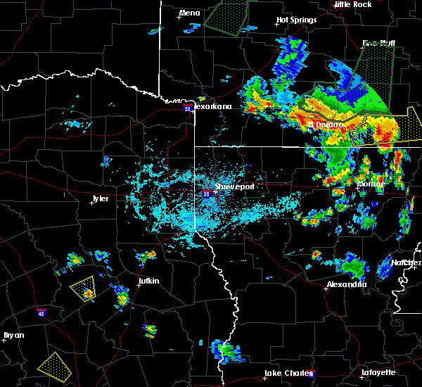 At 650 pm cdt, a severe thunderstorm was located 9 miles southeast of crockett, moving northwest at 15 mph (radar indicated). Hazards include 60 mph wind gusts and quarter size hail. Hail damage to vehicles is expected. Expect wind damage to roofs, siding, and trees. At 650 pm cdt, a severe thunderstorm was located 9 miles southeast of crockett, moving northwest at 15 mph (radar indicated). Hazards include 60 mph wind gusts and quarter size hail. Hail damage to vehicles is expected. Expect wind damage to roofs, siding, and trees.
|
| 3/17/2018 9:33 PM CDT |
 At 932 pm cdt, a severe thunderstorm was located near lovelady, or 9 miles southeast of austonio, moving east at 30 mph (radar indicated). Hazards include 60 mph wind gusts and quarter size hail. Hail damage to vehicles is expected. expect wind damage to roofs, siding, and trees. Locations impacted include, crockett, austonio, lovelady, kennard and pennington. At 932 pm cdt, a severe thunderstorm was located near lovelady, or 9 miles southeast of austonio, moving east at 30 mph (radar indicated). Hazards include 60 mph wind gusts and quarter size hail. Hail damage to vehicles is expected. expect wind damage to roofs, siding, and trees. Locations impacted include, crockett, austonio, lovelady, kennard and pennington.
|
| 3/17/2018 9:06 PM CDT |
 At 905 pm cdt, a severe thunderstorm was located 7 miles southwest of austonio, moving east at 35 mph (public reported 1 inch hail with this storm in leon county). Hazards include 60 mph wind gusts and quarter size hail. Hail damage to vehicles is expected. Expect wind damage to roofs, siding, and trees. At 905 pm cdt, a severe thunderstorm was located 7 miles southwest of austonio, moving east at 35 mph (public reported 1 inch hail with this storm in leon county). Hazards include 60 mph wind gusts and quarter size hail. Hail damage to vehicles is expected. Expect wind damage to roofs, siding, and trees.
|
| 5/28/2017 7:11 PM CDT |
 At 711 pm cdt, severe thunderstorms were located along a line extending from 7 miles southwest of forest to 9 miles west of latexo, moving southeast at 15 mph (radar indicated). Hazards include 60 mph wind gusts and quarter size hail. Hail damage to vehicles is expected. expect wind damage to roofs, siding, and trees. Locations impacted include, crockett, grapeland, kennard, latexo and weches. At 711 pm cdt, severe thunderstorms were located along a line extending from 7 miles southwest of forest to 9 miles west of latexo, moving southeast at 15 mph (radar indicated). Hazards include 60 mph wind gusts and quarter size hail. Hail damage to vehicles is expected. expect wind damage to roofs, siding, and trees. Locations impacted include, crockett, grapeland, kennard, latexo and weches.
|
| 5/28/2017 6:42 PM CDT |
 At 641 pm cdt, severe thunderstorms were located along a line extending from near morrill to 7 miles southwest of crockett, moving east at 35 mph (radar indicated). Hazards include 60 mph wind gusts and quarter size hail. Hail damage to vehicles is expected. Expect wind damage to roofs, siding, and trees. At 641 pm cdt, severe thunderstorms were located along a line extending from near morrill to 7 miles southwest of crockett, moving east at 35 mph (radar indicated). Hazards include 60 mph wind gusts and quarter size hail. Hail damage to vehicles is expected. Expect wind damage to roofs, siding, and trees.
|
| 5/28/2017 6:12 PM CDT |
 At 612 pm cdt, a severe thunderstorm was located 10 miles north of kennard, or 17 miles northeast of crockett, moving east at 20 mph (radar indicated). Hazards include 60 mph wind gusts and quarter size hail. Hail damage to vehicles is expected. expect wind damage to roofs, siding, and trees. Locations impacted include, crockett, grapeland, kennard, latexo and weches. At 612 pm cdt, a severe thunderstorm was located 10 miles north of kennard, or 17 miles northeast of crockett, moving east at 20 mph (radar indicated). Hazards include 60 mph wind gusts and quarter size hail. Hail damage to vehicles is expected. expect wind damage to roofs, siding, and trees. Locations impacted include, crockett, grapeland, kennard, latexo and weches.
|
| 5/28/2017 5:53 PM CDT |
 At 553 pm cdt, a severe thunderstorm was located 9 miles northwest of kennard, or 16 miles northeast of crockett, moving east at 55 mph (radar indicated). Hazards include 60 mph wind gusts and quarter size hail. Hail damage to vehicles is expected. Expect wind damage to roofs, siding, and trees. At 553 pm cdt, a severe thunderstorm was located 9 miles northwest of kennard, or 16 miles northeast of crockett, moving east at 55 mph (radar indicated). Hazards include 60 mph wind gusts and quarter size hail. Hail damage to vehicles is expected. Expect wind damage to roofs, siding, and trees.
|
| 5/11/2017 7:40 PM CDT | Emc updated...3 homes with minor damage from trees falling. small branches down across town. powerlines dow in houston county TX, 0.3 miles ENE of Crockett, TX |
| 5/11/2017 7:39 PM CDT |
 At 739 pm cdt, a severe thunderstorm was located near latexo, or near crockett, moving east at 30 mph (radar indicated). Hazards include 60 mph wind gusts and nickel size hail. Expect damage to roofs, siding, and trees. Locations impacted include, crockett, grapeland, kennard, latexo and weches. At 739 pm cdt, a severe thunderstorm was located near latexo, or near crockett, moving east at 30 mph (radar indicated). Hazards include 60 mph wind gusts and nickel size hail. Expect damage to roofs, siding, and trees. Locations impacted include, crockett, grapeland, kennard, latexo and weches.
|
| 5/11/2017 7:04 PM CDT |
 At 703 pm cdt, a severe thunderstorm was located 12 miles northwest of austonio, moving east at 40 mph (radar indicated). Hazards include quarter size hail. damage to vehicles is expected At 703 pm cdt, a severe thunderstorm was located 12 miles northwest of austonio, moving east at 40 mph (radar indicated). Hazards include quarter size hail. damage to vehicles is expected
|
| 5/3/2017 5:23 PM CDT |
 At 523 pm cdt, a severe thunderstorm was located near wells, or 13 miles north of apple springs, moving east at 35 mph (radar indicated). Hazards include 60 mph wind gusts and quarter size hail. Hail damage to vehicles is expected. expect wind damage to roofs, siding, and trees. Locations impacted include, crockett, austonio, kennard, latexo and centralia. At 523 pm cdt, a severe thunderstorm was located near wells, or 13 miles north of apple springs, moving east at 35 mph (radar indicated). Hazards include 60 mph wind gusts and quarter size hail. Hail damage to vehicles is expected. expect wind damage to roofs, siding, and trees. Locations impacted include, crockett, austonio, kennard, latexo and centralia.
|
| 5/3/2017 4:55 PM CDT |
 At 455 pm cdt, cluster of severe thunderstorms were located near kennard, or 11 miles east of crockett, moving east at 35 mph (radar indicated). Hazards include 60 mph wind gusts and quarter size hail. Hail damage to vehicles is expected. Expect wind damage to roofs, siding, and trees. At 455 pm cdt, cluster of severe thunderstorms were located near kennard, or 11 miles east of crockett, moving east at 35 mph (radar indicated). Hazards include 60 mph wind gusts and quarter size hail. Hail damage to vehicles is expected. Expect wind damage to roofs, siding, and trees.
|
| 5/3/2017 4:45 PM CDT | Quarter sized hail reported 7.9 miles WSW of Crockett, TX |
| 5/3/2017 4:19 PM CDT |
 At 418 pm cdt, a severe thunderstorm was located 8 miles east of buffalo, or 20 miles southeast of fairfield, moving east at 55 mph (radar indicated). Hazards include ping pong ball size hail and 60 mph wind gusts. People and animals outdoors will be injured. expect hail damage to roofs, siding, windows, and vehicles. Expect wind damage to roofs, siding, and trees. At 418 pm cdt, a severe thunderstorm was located 8 miles east of buffalo, or 20 miles southeast of fairfield, moving east at 55 mph (radar indicated). Hazards include ping pong ball size hail and 60 mph wind gusts. People and animals outdoors will be injured. expect hail damage to roofs, siding, windows, and vehicles. Expect wind damage to roofs, siding, and trees.
|
| 4/26/2017 3:27 PM CDT |
 At 327 pm cdt, a severe thunderstorm was located over latexo, or near crockett, moving east at 45 mph (radar indicated). Hazards include 60 mph wind gusts and quarter size hail. Hail damage to vehicles is expected. expect wind damage to roofs, siding, and trees. Locations impacted include, crockett, grapeland, kennard, latexo and weches. At 327 pm cdt, a severe thunderstorm was located over latexo, or near crockett, moving east at 45 mph (radar indicated). Hazards include 60 mph wind gusts and quarter size hail. Hail damage to vehicles is expected. expect wind damage to roofs, siding, and trees. Locations impacted include, crockett, grapeland, kennard, latexo and weches.
|
| 4/26/2017 3:25 PM CDT | Quarter sized hail reported 0.3 miles ENE of Crockett, TX, public reports 1 inch hail in crockett via the ktre-tv facebook page |
| 4/26/2017 3:22 PM CDT | Quarter sized hail reported 3.1 miles SSE of Crockett, TX |
| 4/26/2017 3:16 PM CDT |
 At 316 pm cdt, a severe thunderstorm was located near latexo, or 7 miles west of crockett, moving east at 45 mph (radar indicated). Hazards include 60 mph wind gusts and quarter size hail. Hail damage to vehicles is expected. Expect wind damage to roofs, siding, and trees. At 316 pm cdt, a severe thunderstorm was located near latexo, or 7 miles west of crockett, moving east at 45 mph (radar indicated). Hazards include 60 mph wind gusts and quarter size hail. Hail damage to vehicles is expected. Expect wind damage to roofs, siding, and trees.
|
| 4/2/2017 11:11 AM CDT | At 1111 am cdt, a severe thunderstorm capable of producing a tornado was located over crockett, moving north at 25 mph. a storm spotter reported a funnel cloud southeast of crockett (radar indicated rotation). Hazards include tornado and quarter size hail. Flying debris will be dangerous to those caught without shelter. mobile homes will be damaged or destroyed. damage to roofs, windows, and vehicles will occur. Tree damage is likely. |
| 3/10/2017 7:05 PM CST | Trees down east of latexo on fm202 in houston county TX, 6.4 miles SSW of Crockett, TX |
| 3/10/2017 6:58 PM CST |
 At 656 pm cst, a severe thunderstorm was located 8 miles west of kennard, or 10 miles northeast of crockett, moving northwest at 25 mph. another severe thunderstorm was located 1 mile east of grapeland, moving northwest at 25 mph (radar indicated). Hazards include quarter size hail. Damage to vehicles is expected. Locations impacted include, crockett, grapeland, kennard and latexo. At 656 pm cst, a severe thunderstorm was located 8 miles west of kennard, or 10 miles northeast of crockett, moving northwest at 25 mph. another severe thunderstorm was located 1 mile east of grapeland, moving northwest at 25 mph (radar indicated). Hazards include quarter size hail. Damage to vehicles is expected. Locations impacted include, crockett, grapeland, kennard and latexo.
|
| 3/10/2017 6:55 PM CST |
 At 654 pm cst, a severe thunderstorm was located 7 miles west of kennard, or 10 miles northeast of crockett, moving northwest at 25 mph (radar indicated). Hazards include quarter size hail. damage to vehicles is expected At 654 pm cst, a severe thunderstorm was located 7 miles west of kennard, or 10 miles northeast of crockett, moving northwest at 25 mph (radar indicated). Hazards include quarter size hail. damage to vehicles is expected
|
| 2/20/2017 3:00 AM CST | Power lines down... trees down on highway 7 west between crockett and the county lin in houston county TX, 9.7 miles E of Crockett, TX |
| 1/2/2017 6:59 AM CST |
 At 658 am cst, severe thunderstorms were located along a line extending from 8 miles southwest of maydelle to 15 miles east of madisonville, moving east at 35 mph (radar indicated). Hazards include 60 mph wind gusts. expect damage to roofs, siding, and trees At 658 am cst, severe thunderstorms were located along a line extending from 8 miles southwest of maydelle to 15 miles east of madisonville, moving east at 35 mph (radar indicated). Hazards include 60 mph wind gusts. expect damage to roofs, siding, and trees
|
| 1/2/2017 6:45 AM CST | Houston co sheriffs office reports power lines down in crockett in houston county TX, 0.3 miles ENE of Crockett, TX |
| 5/2/2016 3:51 AM CDT |
 The severe thunderstorm warning for southwestern houston, northeastern walker and west central trinity counties will expire at 400 am cdt, the storm which prompted the warning has weakened below severe limits, and no longer pose an immediate threat to life or property. therefore the warning will be allowed to expire. however small hail is still possible with this thunderstorm. a severe thunderstorm watch remains in effect until 900 am cdt for southeastern texas. to report severe weather, contact your nearest law enforcement agency. they will relay your report to the national weather service league city. The severe thunderstorm warning for southwestern houston, northeastern walker and west central trinity counties will expire at 400 am cdt, the storm which prompted the warning has weakened below severe limits, and no longer pose an immediate threat to life or property. therefore the warning will be allowed to expire. however small hail is still possible with this thunderstorm. a severe thunderstorm watch remains in effect until 900 am cdt for southeastern texas. to report severe weather, contact your nearest law enforcement agency. they will relay your report to the national weather service league city.
|
| 5/2/2016 3:48 AM CDT |
 At 348 am cdt, a severe thunderstorm was located 7 miles east of crockett, moving northeast at 35 mph (radar indicated). Hazards include quarter size hail. damage to vehicles is expected At 348 am cdt, a severe thunderstorm was located 7 miles east of crockett, moving northeast at 35 mph (radar indicated). Hazards include quarter size hail. damage to vehicles is expected
|
| 5/2/2016 3:44 AM CDT |
 At 343 am cdt, a severe thunderstorm was located near lovelady, or 15 miles southeast of austonio, moving northeast at 25 mph. a second severe thunderstorm was located near crockett, moving northeast at 25 mph (radar indicated). Hazards include quarter size hail. Damage to vehicles is expected. Locations impacted include, crockett, lovelady and pennington. At 343 am cdt, a severe thunderstorm was located near lovelady, or 15 miles southeast of austonio, moving northeast at 25 mph. a second severe thunderstorm was located near crockett, moving northeast at 25 mph (radar indicated). Hazards include quarter size hail. Damage to vehicles is expected. Locations impacted include, crockett, lovelady and pennington.
|
| 5/2/2016 3:18 AM CDT |
 At 318 am cdt, a severe thunderstorm was located 12 miles west of trinity, or 14 miles south of austonio, moving northeast at 25 mph (radar indicated). Hazards include quarter size hail. damage to vehicles is expected At 318 am cdt, a severe thunderstorm was located 12 miles west of trinity, or 14 miles south of austonio, moving northeast at 25 mph (radar indicated). Hazards include quarter size hail. damage to vehicles is expected
|
| 4/27/2016 4:26 AM CDT |
 At 425 am cdt, severe thunderstorms were located along a line extending from 8 miles northeast of madisonville to 9 miles west of huntsville to 12 miles west of huntsville state park, moving northeast at 45 mph (radar indicated). Hazards include 60 mph wind gusts. Expect damage to roofs. siding. And trees. At 425 am cdt, severe thunderstorms were located along a line extending from 8 miles northeast of madisonville to 9 miles west of huntsville to 12 miles west of huntsville state park, moving northeast at 45 mph (radar indicated). Hazards include 60 mph wind gusts. Expect damage to roofs. siding. And trees.
|
| 12/27/2015 3:23 PM CST |
 At 322 pm cst, a severe thunderstorm was located 9 miles northwest of kennard, or 12 miles northeast of crockett, moving north at 55 mph. other storms near lovelady may strengthen as they move northward (radar indicated). Hazards include 60 mph wind gusts. Expect damage to roofs. siding and trees. locations impacted include, crockett, kennard, weches and pennington. A tornado watch remains in effect until 700 pm cst for southeastern texas. At 322 pm cst, a severe thunderstorm was located 9 miles northwest of kennard, or 12 miles northeast of crockett, moving north at 55 mph. other storms near lovelady may strengthen as they move northward (radar indicated). Hazards include 60 mph wind gusts. Expect damage to roofs. siding and trees. locations impacted include, crockett, kennard, weches and pennington. A tornado watch remains in effect until 700 pm cst for southeastern texas.
|
| 12/27/2015 3:05 PM CST |
 At 305 pm cst, a severe thunderstorm was located 8 miles northeast of lovelady, or 9 miles southeast of crockett, moving north at 55 mph (radar indicated). Hazards include 60 mph wind gusts. Expect damage to roofs. Siding and trees. At 305 pm cst, a severe thunderstorm was located 8 miles northeast of lovelady, or 9 miles southeast of crockett, moving north at 55 mph (radar indicated). Hazards include 60 mph wind gusts. Expect damage to roofs. Siding and trees.
|
| 12/27/2015 2:42 PM CST |
 At 242 pm cst, a severe thunderstorm was located near lovelady, or 14 miles southeast of austonio, moving north at 65 mph (radar indicated). Hazards include 60 mph wind gusts. Expect damage to roofs. siding and trees. locations impacted include, crockett, trinity, lovelady and latexo. A tornado watch remains in effect until 400 pm cst for southeastern texas. At 242 pm cst, a severe thunderstorm was located near lovelady, or 14 miles southeast of austonio, moving north at 65 mph (radar indicated). Hazards include 60 mph wind gusts. Expect damage to roofs. siding and trees. locations impacted include, crockett, trinity, lovelady and latexo. A tornado watch remains in effect until 400 pm cst for southeastern texas.
|
| 12/27/2015 2:30 PM CST |
 At 229 pm cst, a severe thunderstorm was located near riverside, or 10 miles north of huntsville, moving north at 65 mph (radar indicated). Hazards include 60 mph wind gusts. Expect damage to roofs. Siding and trees. At 229 pm cst, a severe thunderstorm was located near riverside, or 10 miles north of huntsville, moving north at 65 mph (radar indicated). Hazards include 60 mph wind gusts. Expect damage to roofs. Siding and trees.
|
| 5/27/2015 2:55 AM CDT | At 254 am cdt, doppler radar indicated a severe thunderstorm capable of producing damaging winds in excess of 60 mph. this storm was located 8 miles south of kennard, or 14 miles west of apple springs, and moving northeast at 30 mph. |
| 5/25/2015 6:41 PM CDT | At 640 pm cdt, doppler radar indicated a severe thunderstorm capable of producing damaging winds in excess of 60 mph. this storm was located near austonio, and moving northeast at 55 mph. |
| 5/25/2015 6:31 PM CDT | At 631 pm cdt, doppler radar indicated a line of severe thunderstorms capable of producing damaging winds in excess of 60 mph. these storms were located along a line extending from near rusk to near kennard, moving east at 40 mph. locations impacted include, crockett, kennard, latexo and weches. a tornado watch remains in effect until 1000 pm cdt for southeastern texas. |
| 5/25/2015 6:11 PM CDT | At 611 pm cdt, doppler radar indicated a line of severe thunderstorms capable of producing damaging winds in excess of 60 mph. these storms were located along a line extending from 7 miles south of maydelle to near crockett, and moving northeast at 60 mph. |
| 5/25/2015 5:40 PM CDT | At 538 pm cdt, doppler radar indicated a line of severe thunderstorms capable of producing damaging winds in excess of 60 mph. these storms were located along a line extending from 15 miles east of buffalo to 9 miles east of centerville, moving east at 35 mph. locations impacted include, crockett, austonio, grapeland, lovelady, kennard, latexo, weches, and houston county lake. the line of storms will be entering into the northwestern portions of houston county by 545 pm cdt. a tornado watch remains in effect until 1000 pm cdt for southeastern texas. |
| 5/25/2015 5:26 PM CDT | At 525 pm cdt, doppler radar indicated a line of severe thunderstorms capable of producing damaging winds in excess of 60 mph. these storms were located along a line extending from 7 miles southeast of buffalo to near centerville, moving northeast at 55 mph. locations impacted include, crockett, austonio, grapeland, lovelady, kennard, latexo, weches, and houston county lake. a tornado watch remains in effect until 1000 pm cdt for southeastern texas. |
| 5/25/2015 5:11 PM CDT | At 510 pm cdt, doppler radar indicated a line of severe thunderstorms capable of producing damaging winds in excess of 60 mph. these storms were located along a line extending from 12 miles southwest of buffalo to 10 miles southwest of centerville, moving northeast at 55 mph. locations impacted include, crockett, madisonville, austonio, grapeland, lovelady, kennard, latexo, midway, normangee, weches, and houston county lake. a tornado watch remains in effect until 1000 pm cdt for southeastern texas. |
| 5/25/2015 4:51 PM CDT | At 450 pm cdt, doppler radar indicated a line of severe thunderstorms capable of producing damaging winds in excess of 60 mph. these storms were located along a line extending from 15 miles east of bremond to 8 miles east of franklin, and moving northeast at 55 mph. |
| 10/12/2013 1:15 PM CDT | Trees down throughout houston count in houston county TX, 0.3 miles ENE of Crockett, TX |
| 6/6/2013 3:50 PM CDT | Powerlines down in crocket in houston county TX, 0.3 miles ENE of Crockett, TX |
| 6/6/2013 3:50 PM CDT | Trees down throughout houston count in houston county TX, 0.3 miles ENE of Crockett, TX |
| 2/21/2013 11:07 AM CST | Lumber yard building sustained structural damage with tin panels bent and a roof panel picked up and thrown onto the ground. also tree limbs down around tow in houston county TX, 0.3 miles ENE of Crockett, TX |
| 6/14/2012 4:15 AM CDT | Half Dollar sized hail reported 2.7 miles W of Crockett, TX, half dollar size hail reported 3 miles east of the houston county airport along highway 7. |
| 6/14/2012 3:30 AM CDT | Half Dollar sized hail reported 2.7 miles W of Crockett, TX, half dollar size hail reported 3 miles east of the houston county airport along highway 7. |
| 1/1/0001 12:00 AM | Trees down across houston county in houston county TX, 0.3 miles ENE of Crockett, TX |
| 1/1/0001 12:00 AM | Trees down across houston count in houston county TX, 0.3 miles ENE of Crockett, TX |
| 1/1/0001 12:00 AM | Quarter sized hail reported 8.7 miles SE of Crockett, TX, houston county lake |
| 1/1/0001 12:00 AM | Quarter sized hail reported 4.8 miles S of Crockett, TX |
| 1/1/0001 12:00 AM | 2 mobile homes damaged one severely. no one injured. time estimate in houston county TX, 0.8 miles E of Crockett, TX |
Hail Maps for Crockett, TX
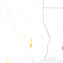


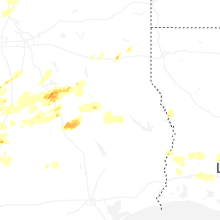

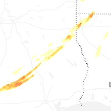


Connect with Interactive Hail Maps