

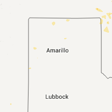
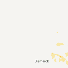
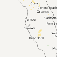
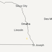
Hail Map for Friday, August 12, 2011

Number of Impacted Households on 8/12/2011
0
Impacted by 1" or Larger Hail
0
Impacted by 1.75" or Larger Hail
0
Impacted by 2.5" or Larger Hail
Square Miles of Populated Area Impacted on 8/12/2011
0
Impacted by 1" or Larger Hail
0
Impacted by 1.75" or Larger Hail
0
Impacted by 2.5" or Larger Hail


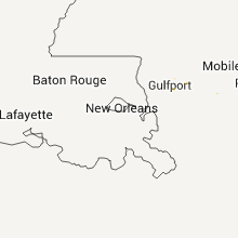

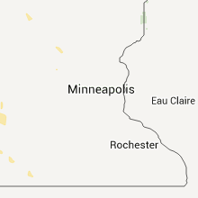


Cities Most Affected by Hail Storms of 8/12/2011
| Hail Size | Demographics of Zip Codes Affected | ||||||
|---|---|---|---|---|---|---|---|
| City | Count | Average | Largest | Pop Density | House Value | Income | Age |
| Pollocksville, NC | 2 | 1.75 | 1.75 | 25 | $84k | $35.2k | 47.0 |
| Larned, KS | 1 | 2.50 | 2.50 | 16 | $52k | $34.2k | 42.2 |
| Fleming Island, FL | 1 | 1.75 | 1.75 | 1782 | $0k | $0.0k | 40.4 |
| Stantonsburg, NC | 1 | 1.75 | 1.75 | 36 | $70k | $31.6k | 42.2 |
| Arkadelphia, AR | 1 | 1.75 | 1.75 | 37 | $76k | $29.8k | 33.0 |
Hail and Wind Damage Spotted on 8/12/2011
Filter by Report Type:Hail ReportsWind Reports
States Impacted
North Carolina, South Carolina, Missouri, North Dakota, Florida, Alabama, Michigan, Georgia, Kansas, Oklahoma, Illinois, Virginia, Arkansas, Arizona, Wisconsin, New Mexico, TexasNorth Carolina
| Local Time | Report Details |
|---|---|
| 3:18 PM UTC | Tree down on a power line in franklin county NC, 23.9 miles ENE of Raleigh, NC |
| 3:42 PM UTC | Quarter sized hail reported near Jacksonville, NC, 49 miles NE of Wilmington, NC |
| 3:45 PM UTC | Quarter sized hail reported near Jacksonville, NC, 49.2 miles NE of Wilmington, NC |
| 4:25 PM UTC | Tree down on white oak road. relayed from 911 cente in jones county NC, 61.5 miles NE of Wilmington, NC |
| 4:26 PM UTC | Tree down near pine street in wilson county NC, 40.9 miles E of Raleigh, NC |
| 4:30 PM UTC | Golf Ball sized hail reported near Pollocksville, NC, 64.4 miles NE of Wilmington, NC, golf ball size hail damaged several mobile homes and crops |
| 4:32 PM UTC | Golf Ball sized hail reported near Pollocksville, NC, 65.2 miles NE of Wilmington, NC, jones county sheriffs deputy reported golf ball size hail off davis field road near pollocksville. |
| 4:35 PM UTC | Golf Ball sized hail reported near Stantonsburg, NC, 47.3 miles ESE of Raleigh, NC, golfball size hail was reported. two trees were also blown down. |
| 4:35 PM UTC | Power poles down at wilson county water treatment plant - plant without power in wilson county NC, 49 miles E of Raleigh, NC |
| 4:40 PM UTC | Trees and power poles and lines down on hwy 5 in jones county NC, 65.4 miles NE of Wilmington, NC |
| 4:53 PM UTC | Trees down in stantonsburg in wilson county NC, 47.8 miles ESE of Raleigh, NC |
| 5:03 PM UTC | Dime sized hail and trees down on west college st in wayne county NC, 52 miles SE of Raleigh, NC |
| 5:15 PM UTC | Gas station awning blown down in mount olive in wayne county NC, 51.7 miles SE of Raleigh, NC |
| 5:15 PM UTC | Several trees down on mount olive college campus in wayne county NC, 51.2 miles SE of Raleigh, NC |
| 5:15 PM UTC | Building blown off of foundation in wayne county NC, 55.9 miles SE of Raleigh, NC |
| 5:19 PM UTC | Spotter reported trees down and heavy rain on beautancus road in beautancu in duplin county NC, 57.4 miles SE of Raleigh, NC |
| 5:23 PM UTC | Powerlines and trees down on sandpit roa in greene county NC, 52.4 miles ESE of Raleigh, NC |
| 5:23 PM UTC | Trees down on beaman old creek road with marble size hai in greene county NC, 56.1 miles ESE of Raleigh, NC |
| 5:25 PM UTC | Trees down on maysville school roa in duplin county NC, 58.5 miles SE of Raleigh, NC |
| 5:25 PM UTC | Building destroyed near the 200 block of hwy 403. possible tornad in duplin county NC, 55.4 miles SE of Raleigh, NC |
| 5:25 PM UTC | Welding shop destroyed near the 200 block of hwy 403 by straight line winds. winds estimated at 70 to 80 mp in duplin county NC, 55.4 miles SE of Raleigh, NC |
| 5:29 PM UTC | Spotter reported trees and powerlines down on sam miller road just south of warsa in duplin county NC, 52.7 miles N of Wilmington, NC |
| 5:33 PM UTC | Tree down on rabbit hollow road. time estimated from rada in greene county NC, 57.1 miles ESE of Raleigh, NC |
| 6:57 PM UTC | One tree down on willoughby roa in union county NC, 19.9 miles SE of Charlotte, NC |
| 8:10 PM UTC | Trees and power lines down along stag park road between i-40 and highway 5 in pender county NC, 23.2 miles N of Wilmington, NC |
South Carolina
| Local Time | Report Details |
|---|---|
| 4:16 PM UTC | Large limbs down near holmes bridge rd in laurens county SC, 45.8 miles SE of Greenville, SC |
| 8:03 PM UTC | Trees down on glover roa in jasper county SC, 28.7 miles NNE of Savannah, GA |
| 8:05 PM UTC | Trees down on chickadee stree in jasper county SC, 28.4 miles NNE of Savannah, GA |
| 8:07 PM UTC | Trees down on honey lan in jasper county SC, 26.1 miles NNE of Savannah, GA |
| 8:25 PM UTC | *** 1 inj *** a fire dept reported one tree down and on a car near the intersection of highwy 46 and rose deu creek plantation. 1 person was injured. extent of injuries in beaufort county SC, 14.3 miles NE of Savannah, GA |
| 8:25 PM UTC | *** 1 inj *** a fire dept reported one tree down and on a car near the intersection of hwy 46 and rose dhu creek plantation. 1 person was injured. extent of injuries un in beaufort county SC, 14.3 miles NE of Savannah, GA |
| 8:30 PM UTC | Law enforcement reported one tree down near the intersection of augusta highway and patterson mill roa in allendale county SC, 37.1 miles SE of Augusta, GA |
| 8:30 PM UTC | A fire department reported one 4 to 5 inch diameter branch fell onto the fire dept buildin in beaufort county SC, 17.9 miles NE of Savannah, GA |
| 9:15 PM UTC | Trees down at the intersection of highway 78 and cedar r in aiken county SC, 26.3 miles E of Augusta, GA |
| 9:55 PM UTC | Dispatch center reported a tree down blocking both lanes of cypress creek r in hampton county SC, 41.7 miles N of Savannah, GA |
| 11:20 PM UTC | Fire department cleared a tree from mush creek road that was a live green tree. wind was quite strong in the area but does not know of any other trees or limbs down at in greenville county SC, 20.1 miles NE of Greenville, SC |
| 11:32 PM UTC | Trees and large limbs down along smith grove road. power is also reported to be out for parts of this area near easle in pickens county SC, 1.8 miles SW of Greenville, SC |
| 11:38 PM UTC | Half Dollar sized hail reported near Liberty, SC, 4.4 miles SW of Greenville, SC, hail estimated to be half dollar sized fell about 2 miles east of liberty. |
| 11:40 PM UTC | Public report of trees dow in pickens county SC, 7.2 miles WSW of Greenville, SC |
| 11:40 PM UTC | Reports of 50 to 60 trees blown down in vicinity of johnson road and zion church road. a few trees on house in pickens county SC, 2.9 miles SSE of Greenville, SC |
| 12:15 AM UTC | Large limbs and one tree down off of chantilly ln nr lake hartwell in anderson county SC, 20.1 miles SSW of Greenville, SC |
| 12:50 AM UTC | Many trees down in this area...worst on west pine grove road...trees and powerlines down on river bend road...trees down on dairy farm road and trees down on shore driv in oconee county SC, 29.9 miles SW of Greenville, SC |
| 12:55 AM UTC | A few trees down in the fair play are in oconee county SC, 31.3 miles SW of Greenville, SC |
| 1:00 AM UTC | *** 7 inj *** county reports camper overturned by wind with multiple injuries to persons inside. numerous trees blown down along campers way...highway 29...and ginn roa in anderson county SC, 33.5 miles SSW of Greenville, SC |
Missouri
| Local Time | Report Details |
|---|---|
| 4:42 PM UTC | Quarter sized hail reported near Pleasant Hill, MO, 25.3 miles SE of Kansas City, MO |
| 9:20 PM UTC | Power lines blown dow in washington county MO, 37.4 miles NE of Salem, MO |
| 9:29 PM UTC | Three inch diameter tree limbs blown dow in washington county MO, 45.4 miles ENE of Salem, MO |
| 9:33 PM UTC | Two to three inch tree limbs blown dow in washington county MO, 45.5 miles ENE of Salem, MO |
| 9:40 PM UTC | One to two inch tree limbs blown down around tow in washington county MO, 39 miles ENE of Salem, MO |
| 9:45 PM UTC | Emergency manager estimated wind gusts up to 60 mph. several trees and power lines blown down in the city of salem. one tree fell on hous in dent county MO, 0.9 miles NNW of Salem, MO |
| 9:55 PM UTC | Several trees blown down. minor roof damage to outbuildin in dent county MO, 11 miles ESE of Salem, MO |
| 9:58 PM UTC | Numerous tree limbs blown down...so of which were six inches in diamete in st. francois county MO, 55.8 miles SSW of Saint Louis, MO |
| 10:00 PM UTC | Estimated 65 to 70 mph winds at lake killarney...no damage so fa in iron county MO, 53.6 miles E of Salem, MO |
| 10:00 PM UTC | Estimated 65 to 70 mph winds...no damage so fa in iron county MO, 53.6 miles E of Salem, MO |
| 10:00 PM UTC | Lots of two to three inch tree limbs blown down...one six inch tree limb blown down at lake killarne in iron county MO, 53.6 miles E of Salem, MO |
| 10:23 PM UTC | Several large trees blown dow in ste. genevieve county MO, 52.3 miles S of Saint Louis, MO |
| 11:38 PM UTC | Quarter sized hail reported near Myrtle, MO, 79.1 miles S of Salem, MO |
North Dakota
| Local Time | Report Details |
|---|---|
| 6:30 PM UTC | Half Dollar sized hail reported near Sheyenne, ND, 30.4 miles SW of Devils Lake, ND, torrential rains with numerous nickel to walnut sized hail. hail began smaller and increased in size from about 125 to 130 pm cdt. |
| 7:25 PM UTC | Quarter sized hail reported near Cleveland, ND, 76.7 miles E of Bismarck, ND, lasted a few minutes. very heavy rain. 50 mph wind gusts. |
| 7:31 PM UTC | Quarter sized hail reported near Jamestown, ND, 91.2 miles N of Aberdeen, SD, lasted around 5 minutes. |
| 7:50 PM UTC | Quarter sized hail reported near Lakota, ND, 23.5 miles E of Devils Lake, ND, also measued 3.30 inches of rain during the storm. |
| 8:13 PM UTC | Quarter sized hail reported near Montpelier, ND, 81.7 miles N of Aberdeen, SD, 1.83 inches of rain in 20 minutes. |
| 8:25 PM UTC | Quarter sized hail reported near Montpelier, ND, 85.8 miles N of Aberdeen, SD, lasted around 5 minutes |
| 8:38 PM UTC | Quarter sized hail reported near Berlin, ND, 59.5 miles N of Aberdeen, SD |
| 8:45 PM UTC | Quarter sized hail reported near Lamoure, ND, 62.9 miles N of Aberdeen, SD, minor street flooding reported. |
| 9:00 PM UTC | Quarter sized hail reported near Litchville, ND, 70.6 miles WSW of Fargo, ND |
| 9:00 PM UTC | Quarter sized hail reported near Finley, ND, 58.5 miles NW of Fargo, ND, quarter to nickel hail caused crop damage. |
| 10:35 PM UTC | Ping Pong Ball sized hail reported near Grandin, ND, 27.9 miles NNW of Fargo, ND, a few hail stones walnut size. time approximate. |
Florida
| Local Time | Report Details |
|---|---|
| 6:45 PM UTC | A few trees and powerlines down east of capps on us-27. time estimated by rada in jefferson county FL, 25.2 miles E of Tallahassee, FL |
| 8:40 PM UTC | Three large trees were blown down across huninton road at the railroad tracks. the amtrack train had to be stopped an the tracks were still being cleared of debris abou in putnam county FL, 61.7 miles S of Jacksonville, FL |
| 8:40 PM UTC | Trees were blown down at oleander street and lake margaret boulevar in putnam county FL, 60.8 miles S of Jacksonville, FL |
| 8:50 PM UTC | Trees were blown down at sunset driev and hess roa in putnam county FL, 61.6 miles NNW of Orlando, FL |
| 9:05 PM UTC | Numerous trees were blown down in the anthony cith limits. the time of damage was based on radar imager in marion county FL, 68.2 miles NW of Orlando, FL |
| 10:00 PM UTC | A home was damaged by a fallen tree. no injuries were reported. the time of the event was based on rada in nassau county FL, 19.4 miles N of Jacksonville, FL |
| 10:10 PM UTC | Tree was reported blown down at 1550 w newberry r in alachua county FL, 69.5 miles SW of Jacksonville, FL |
| 10:20 PM UTC | Marion county dispatch reported widespread tree damage along highway 301 and county road 318 in the city limits of citra. an hour later numerous road crews were out sti in marion county FL, 68.4 miles SSW of Jacksonville, FL |
| 6:33 PM EDT | Golf Ball sized hail reported near Fleming Island, FL, 15.5 miles S of Jacksonville, FL, golfball size hail was reported along u.s. highway 17 on the northend of fleming island across from pace island. |
| 6:35 PM EDT | Quarter sized hail reported near Orange Park, FL, 12.6 miles SSW of Jacksonville, FL, quarter size hail was reported along moody drive near doctors lake. |
| 10:50 PM UTC | Law enforcement reported a small tree down on victoria driv in st. johns county FL, 38.2 miles SSE of Jacksonville, FL |
| 6:53 PM EDT | Law enforcement reported a tree down on maxville middleburg roa in duval county FL, 23.3 miles WSW of Jacksonville, FL |
| 6:55 PM EDT | Law enforcement reported a tree down in the mandarin are in duval county FL, 12.5 miles S of Jacksonville, FL |
| 11:00 PM UTC | Law enforcement reported a tree down on bishop estates roa in st. johns county FL, 43.3 miles SSE of Jacksonville, FL |
| 11:10 PM UTC | 2 trees were reported blown down at the bradford motel and campground in starke. one tree fell on a vehicle. another tree was reported down on ne 28th ave near this are in bradford county FL, 36.9 miles SW of Jacksonville, FL |
| 11:15 PM UTC | The jacksonville electric authority confirmed that power line crews responded to scattered power outages across the jacksonville southside inlcuding along san pablo and in duval county FL, 13.6 miles ESE of Jacksonville, FL |
| 11:25 PM UTC | Law enforcement reported a tree and power line down on mickler road in the ponte vedra area. two tree fires caused by lightning were also reported in this are in st. johns county FL, 20.8 miles SE of Jacksonville, FL |
| 11:35 PM UTC | An employee at the t and f electric company reported several trees down along breezy point roa in marion county FL, 80.9 miles WNW of Orlando, FL |
| 11:35 PM UTC | The t and f eletric company reported several trees down along sw big tree roa in marion county FL, 81.7 miles WNW of Orlando, FL |
Alabama
| Local Time | Report Details |
|---|---|
| 7:00 PM UTC | A tree was blown down onto powerline in mobile county AL, 5.8 miles W of Mobile, AL |
Michigan
| Local Time | Report Details |
|---|---|
| 8:20 PM UTC | Quarter sized hail reported near Lakefield, MI, 74 miles WSW of Sault Sainte Marie, MI, nickel to quarter-sized hail observed at the far west end of big manistique lake near germfask. |
Georgia
| Local Time | Report Details |
|---|---|
| 8:24 PM UTC | 6 pine tree snapped along palmetto drive southeast of rinco in effingham county GA, 14.8 miles NNW of Savannah, GA |
| 10:30 PM UTC | Law enforcement reported a tree and a powerline down in st. marys. a retired nws employee estimated the winds at 50 to 55 mph in this are in camden county GA, 27 miles NNE of Jacksonville, FL |
| 10:40 PM UTC | Trees and power lines down on lake gale dr and intersection of hwy 18 and hwy 8 in liberty county GA, 26.9 miles SW of Savannah, GA |
| 12:00 AM UTC | Tree limbs about 4 inches in diameter were blown down. a weighted canopy was blown down on base outside of a store front. there were some power outages along spurr 40 w in camden county GA, 32.8 miles NNE of Jacksonville, FL |
| 1:30 AM UTC | Reports of trees down across the county...especially on east sid in hart county GA, 38.1 miles SSW of Greenville, SC |
Kansas
| Local Time | Report Details |
|---|---|
| 9:08 PM UTC | Quarter sized hail reported near Burdett, KS, 48.2 miles SSW of Hays, KS |
| 9:17 PM UTC | Storm damage reported in hodgeman county KS, 54.3 miles E of Garden City, KS |
| 9:17 PM UTC | Half Dollar sized hail reported near Jetmore, KS, 54.3 miles E of Garden City, KS |
| 9:46 PM UTC | Tennis Ball sized hail reported near Larned, KS, 42.1 miles S of Hays, KS |
| 9:50 PM UTC | Storm damage reported in ford county KS, 55.9 miles E of Garden City, KS |
| 9:50 PM UTC | Railroad crossing arm blown off in ford county KS, 55.3 miles ESE of Garden City, KS |
| 10:00 PM UTC | Storm damage reported in edwards county KS, 66.4 miles S of Hays, KS |
| 10:00 PM UTC | Ping Pong Ball sized hail reported near Kinsley, KS, 66.4 miles S of Hays, KS |
| 10:03 PM UTC | Large limbs down over 183 in kinsley in edwards county KS, 65.7 miles S of Hays, KS |
| 10:22 PM UTC | 1 inch live tree limbs dow in edwards county KS, 74.6 miles S of Hays, KS |
| 10:29 PM UTC | Quarter size hail as well mixed in with nickel size hail in edwards county KS, 71.9 miles S of Hays, KS |
| 10:29 PM UTC | Quarter sized hail reported near Ellery, KS, 71.9 miles S of Hays, KS |
| 10:34 PM UTC | Quarter sized hail reported near Coldwater, KS, 52.3 miles N of Woodward, OK |
| 10:37 PM UTC | Storm damage reported in edwards county KS, 75.1 miles S of Hays, KS |
| 10:39 PM UTC | Storm damage reported in pratt county KS, 86.3 miles NNE of Woodward, OK |
| 10:42 PM UTC | Trees being torn in kiowa county KS, 83 miles N of Woodward, OK |
| 10:45 PM UTC | Three inch tree limbs were blown dow in kiowa county KS, 81.9 miles N of Woodward, OK |
| 11:01 PM UTC | Storm damage reported in pratt county KS, 83.1 miles W of Wichita, KS |
| 11:07 PM UTC | Storm damage reported in pratt county KS, 82 miles W of Wichita, KS |
| 11:11 PM UTC | Storm damage reported in pratt county KS, 77.6 miles W of Wichita, KS |
| 11:15 PM UTC | Homeowner lost a few wood shingles on home from the strong thunderstorm wind in kiowa county KS, 75.1 miles NNE of Woodward, OK |
| 11:16 PM UTC | Storm damage reported in pratt county KS, 77.5 miles W of Wichita, KS |
| 11:22 PM UTC | Storm damage reported in pratt county KS, 77 miles W of Wichita, KS |
| 11:22 PM UTC | Numerous trees damaged in pratt with 3 to 6 inch limbs dow in pratt county KS, 77 miles W of Wichita, KS |
| 11:23 PM UTC | Tops of power poles snapped at 20th st sw of pratt in pratt county KS, 78.2 miles W of Wichita, KS |
| 11:27 PM UTC | 35 foot trailer was blown on top of a chevy suburba in pratt county KS, 76.7 miles W of Wichita, KS |
| 11:39 PM UTC | Storm damage reported in barber county KS, 73.7 miles WSW of Wichita, KS |
| 12:00 AM UTC | Spotter estimated 85 mph wind gust in attic in harper county KS, 58 miles WSW of Wichita, KS |
| 12:01 AM UTC | Some tree limbs were downe in harper county KS, 58 miles WSW of Wichita, KS |
| 12:01 AM UTC | Some tree limbs were downe in harper county KS, 57.2 miles WSW of Wichita, KS |
| 12:08 AM UTC | Observer estimated at least 60 mph wind gust. noted small limbs blown off of tree in harper county KS, 54.4 miles SW of Wichita, KS |
| 12:09 AM UTC | Storm damage reported in harper county KS, 51.8 miles SW of Wichita, KS |
| 12:11 AM UTC | Observer estimated at least 60 mph gust that blew small limbs off of his tree in harper county KS, 54.4 miles SW of Wichita, KS |
| 12:11 AM UTC | Small limbs reported to be blown from tree in harper county KS, 54.4 miles SW of Wichita, KS |
| 12:24 AM UTC | Observed limbs blown down in neighbors yard with estimated 70 mph gus in harper county KS, 53.2 miles SW of Wichita, KS |
| 12:25 AM UTC | Storm damage reported in harper county KS, 41 miles SW of Wichita, KS |
| 12:38 AM UTC | Storm damage reported in mcpherson county KS, 50.4 miles NNW of Wichita, KS |
| 12:41 AM UTC | Half Dollar sized hail reported near Galva, KS, 49.5 miles NNW of Wichita, KS |
| 12:45 AM UTC | Quarter sized hail reported near Galva, KS, 48.6 miles N of Wichita, KS |
| 12:45 AM UTC | Storm damage reported in mcpherson county KS, 49.5 miles NNW of Wichita, KS |
| 12:50 AM UTC | Storm damage reported in sumner county KS, 34.1 miles SSW of Wichita, KS |
| 12:53 AM UTC | Storm damage reported in mcpherson county KS, 36.8 miles NNW of Wichita, KS |
| 1:00 AM UTC | Storm damage reported in marion county KS, 39.5 miles N of Wichita, KS |
| 1:05 AM UTC | Delayed report from a trained spotter of 60 to 70 mph winds and pea hai in marion county KS, 38.8 miles N of Wichita, KS |
| 1:05 AM UTC | Trees described as damaged in marion county KS, 35.4 miles N of Wichita, KS |
| 1:05 AM UTC | Delayed report from trained spotter of 6 to 8 inch tree limbs down as well as several powerline in marion county KS, 38.8 miles N of Wichita, KS |
| 1:10 AM UTC | Numerous branches down in mcpherson county KS, 33.4 miles N of Wichita, KS |
| 1:10 AM UTC | 12 inch diameter tree down in mcpherson county KS, 33.4 miles N of Wichita, KS |
| 1:17 AM UTC | Storm damage reported in harvey county KS, 24.3 miles N of Wichita, KS |
| 1:18 AM UTC | Storm damage reported in harvey county KS, 25 miles N of Wichita, KS |
| 1:29 AM UTC | Storm damage reported in butler county KS, 27.4 miles NNE of Wichita, KS |
| 1:30 AM UTC | Storm damage reported in marion county KS, 37 miles NE of Wichita, KS |
| 1:30 AM UTC | 4 inch tree limbs dow in butler county KS, 27.4 miles NNE of Wichita, KS |
| 1:30 AM UTC | Leaves stripped from trees and reported an antenna blown off roo in butler county KS, 27.4 miles NNE of Wichita, KS |
| 1:30 AM UTC | Report of a railroad tie being picked up and damaging a fence. also reported an alumminum flagpole being snapped in half and several tree limbs at least 3 inches in dia in butler county KS, 20 miles ENE of Wichita, KS |
| 1:35 AM UTC | Tree damage due to strong winds in harvey county KS, 22.1 miles NNE of Wichita, KS |
| 1:48 AM UTC | Storm damage reported in butler county KS, 20.8 miles NE of Wichita, KS |
| 1:49 AM UTC | Storm damage reported in butler county KS, 31.3 miles NE of Wichita, KS |
| 1:50 AM UTC | Storm damage reported in sedgwick county KS, 7.7 miles NE of Wichita, KS |
| 1:50 AM UTC | Storm damage reported in sedgwick county KS, 7.7 miles NE of Wichita, KS |
| 1:50 AM UTC | Report of a railroad tie being picked up and damaging a fence. also reported an alumminum flagpole being snapped in half and several tree limbs at least 3 inches in dia in butler county KS, 20 miles ENE of Wichita, KS |
| 1:53 AM UTC | Storm damage reported in butler county KS, 30.2 miles ENE of Wichita, KS |
| 2:03 AM UTC | Power lines dow in butler county KS, 22 miles ENE of Wichita, KS |
| 2:16 AM UTC | 60-65 mph winds estimated in butler county KS, 34.3 miles E of Wichita, KS |
| 2:24 AM UTC | Storm damage reported in labette county KS, 25.6 miles SSE of Chanute, KS |
Oklahoma
| Local Time | Report Details |
|---|---|
| 10:00 PM UTC | Lindsay pd in garvin county OK, 43.9 miles S of Oklahoma City, OK |
| 10:10 PM UTC | Gusts to 60 and higher along outflow gust front ahead of thunderstorm in cherokee county OK, 48.1 miles NW of Fort Smith, AR |
| 10:30 PM UTC | Tree blown over onto mobile home on west side of city. power line reported downed on east side. time approximat in cherokee county OK, 48.1 miles NW of Fort Smith, AR |
| 10:45 PM UTC | Quarter sized hail reported near Tahlequah, OK, 49.6 miles NW of Fort Smith, AR |
| 10:50 PM UTC | Tree downed on mobile home. multiple 8-12 inch diameter trees fallen around tow in cherokee county OK, 48.1 miles NW of Fort Smith, AR |
| 11:27 PM UTC | Kwwr awos in woodward county OK, 5.6 miles W of Woodward, OK |
| 11:30 PM UTC | Quarter sized hail reported near Muskogee, OK, 44.5 miles SE of Tulsa, OK, east side... |
| 11:35 PM UTC | Major damage to the vo/ag building at fargo. /corrected time and location of fargo instead of woodward/ in ellis county OK, 13.1 miles WSW of Woodward, OK |
| 11:45 PM UTC | Kwdg awos in garfield county OK, 63.6 miles NNW of Oklahoma City, OK |
| 11:45 PM UTC | Moderate roof damage apt cmplx west side of town in woodward county OK, 0.6 miles ESE of Woodward, OK |
| 11:45 PM UTC | 80 x 120 ft pole barn destroyed in ellis county OK, 21 miles WNW of Woodward, OK |
| 11:50 PM UTC | Major dmg vo/ag bldg woodward h. in woodward county OK, 0.6 miles ESE of Woodward, OK |
| 11:50 PM UTC | Moderate roof dmg woodward fire dept in woodward county OK, 0.6 miles ESE of Woodward, OK |
| 12:10 AM UTC | Storm damage reported in alfalfa county OK, 61.3 miles ENE of Woodward, OK |
| 1:06 AM UTC | Nash pd 55-60 mph gust in grant county OK, 76.8 miles ENE of Woodward, OK |
| 1:25 AM UTC | Hillsdale fd in garfield county OK, 78.9 miles E of Woodward, OK |
| 1:30 AM UTC | Storm damage reported in major county OK, 70.8 miles NNW of Oklahoma City, OK |
| 1:40 AM UTC | Power lines down intersection of washington and broadway in garfield county OK, 67.1 miles NNW of Oklahoma City, OK |
| 1:43 AM UTC | Power lines down intersection of 15th and randolph in garfield county OK, 66.8 miles NNW of Oklahoma City, OK |
| 2:15 AM UTC | Storm damage reported in logan county OK, 43.5 miles N of Oklahoma City, OK |
| 2:20 AM UTC | Storm damage reported in logan county OK, 43.5 miles N of Oklahoma City, OK |
| 2:30 AM UTC | Storm damage reported in custer county OK, 59.4 miles S of Woodward, OK |
| 3:00 AM UTC | Storm damage reported in washita county OK, 73.2 miles SSE of Woodward, OK |
| 3:08 AM UTC | Kclk awos in custer county OK, 68.5 miles SSE of Woodward, OK |
| 3:19 AM UTC | Hefner and county line rd in canadian county OK, 11.3 miles NW of Oklahoma City, OK |
| 3:23 AM UTC | Penn and edmond rd in oklahoma county OK, 12.4 miles N of Oklahoma City, OK |
Illinois
| Local Time | Report Details |
|---|---|
| 10:15 PM UTC | Storm damage reported in stephenson county IL, 57.6 miles S of Madison, WI |
| 10:50 PM UTC | 4-5 inch diameter tree limbs dow in stephenson county IL, 59.1 miles S of Madison, WI |
| 11:32 PM UTC | Several 3 to 6 inch diameter tree limbs down. estimated tim in ogle county IL, 68 miles S of Madison, WI |
| 11:32 PM UTC | Several 3 to 6 inch diameter tree limbs down. estimated time. relayed by wif in ogle county IL, 68 miles S of Madison, WI |
| 11:42 PM UTC | Several 3 to 6 inch diameter tree limbs down. estimated time. relayed by wif in ogle county IL, 68 miles S of Madison, WI |
Virginia
| Local Time | Report Details |
|---|---|
| 10:25 PM UTC | A couple of trees and a power line down near cedar point lan in pulaski county VA, 41 miles WSW of Roanoke, VA |
Arkansas
| Local Time | Report Details |
|---|---|
| 11:40 PM UTC | Large tree fell on a house. significant structural damag in sebastian county AR, 14.6 miles SE of Fort Smith, AR |
| 12:10 AM UTC | One tree blown down near whipporwill and ware road. many broken tree limbs. house struck by lightning. all in greenwood are in sebastian county AR, 14.6 miles SE of Fort Smith, AR |
| 12:22 AM UTC | Trees down in cauksvill in logan county AR, 31.7 miles E of Fort Smith, AR |
| 12:30 AM UTC | Trees down in booneville in logan county AR, 33 miles ESE of Fort Smith, AR |
| 1:11 AM UTC | Quarter sized hail reported near Black Rock, AR, 89.2 miles NW of Memphis, TN, dime to quarter size hail and gusty winds in the town of black rock. |
| 1:20 AM UTC | Trees and powerlines down in pope county AR, 51.1 miles NW of Little Rock, AR |
| 1:40 AM UTC | Trees were blown down and small outbuildings were damaged at buckvill in garland county AR, 55 miles NNE of Nashville, AR |
| 1:50 AM UTC | Numerous tress and powerlines down in the city. several street signs also blown ove in conway county AR, 38.8 miles NW of Little Rock, AR |
| 1:50 AM UTC | Trees and powerlines down. street signs blown dow in pope county AR, 56 miles NW of Little Rock, AR |
| 1:50 AM UTC | Quarter sized hail reported near Morrilton, AR, 38.8 miles NW of Little Rock, AR |
| 1:58 AM UTC | Numerous trees down on highway in conway county AR, 37.6 miles NW of Little Rock, AR |
| 2:00 AM UTC | Trees and powerlines down in perry county AR, 34.9 miles WNW of Little Rock, AR |
| 2:06 AM UTC | Tree fell on a business. power poles down in tow in jackson county AR, 69.4 miles NE of Little Rock, AR |
| 2:17 AM UTC | Trees were blown down across roads and power lines were blown dow in garland county AR, 52.2 miles WSW of Little Rock, AR |
| 2:23 AM UTC | There were multiple reports of trees down in roadways and power lines down on the east side of hot springs... including mississippi s in garland county AR, 47.7 miles WSW of Little Rock, AR |
| 2:24 AM UTC | Trees were blown down blocking the road in the gulpha gorge are in garland county AR, 46.1 miles WSW of Little Rock, AR |
| 2:31 AM UTC | Trees and power lines were blown dow in hot spring county AR, 46.5 miles NE of Nashville, AR |
| 2:31 AM UTC | Trees and power lines were blown dow in hot spring county AR, 52.7 miles ENE of Nashville, AR |
| 2:35 AM UTC | Wind gusts estimated at 60 to 65 mph in maumell in pulaski county AR, 10.4 miles NW of Little Rock, AR |
| 2:36 AM UTC | Several large trees were blown down in august in woodruff county AR, 63.9 miles NE of Little Rock, AR |
| 2:45 AM UTC | Numerous trees down in bryant. winds estimated to be 60 to 70 mp in saline county AR, 15.6 miles SW of Little Rock, AR |
| 3:05 AM UTC | A tree was blown down onto a vehicle on caney road. it is unknown if there were any injurie in hot spring county AR, 49 miles ENE of Nashville, AR |
| 3:17 AM UTC | Trees were blown down on u.s. 27 in grant county AR, 36.2 miles SW of Little Rock, AR |
| 3:17 AM UTC | Trees were blown dow in grant county AR, 33.2 miles SSW of Little Rock, AR |
| 6:20 AM UTC | Golf Ball sized hail reported near Arkadelphia, AR, 39.4 miles E of Nashville, AR |
Arizona
| Local Time | Report Details |
|---|---|
| 11:45 PM UTC | Downed in gila county AZ, 66.5 miles SSW of Show Low, AZ |
| 11:50 PM UTC | Numerous power poles down in and around san carlo in gila county AZ, 66.5 miles SSW of Show Low, AZ |
| 1:28 AM UTC | Storm damage reported in graham county AZ, 79 miles W of Silver City, NM |
Wisconsin
| Local Time | Report Details |
|---|---|
| 12:20 AM UTC | Trees and power lines down near intersection of highway p and allen rd. time estimate in dodge county WI, 55.3 miles ENE of Madison, WI |
| 12:40 AM UTC | At rock lake...boats on lifts moved...one 40 to 50 yards from its original spot. 2 foot tree snapped at base. observed from intersection of lakeshore drive and college in jefferson county WI, 24.1 miles E of Madison, WI |
| 12:40 AM UTC | Winds blew over a boat on a lift at rock lake. trees also down in lake mills. time estimate in jefferson county WI, 24.1 miles E of Madison, WI |
New Mexico
| Local Time | Report Details |
|---|---|
| 12:45 AM UTC | Schoolnet sit in curry county NM, 57 miles SSE of Tucumcari, NM |
| 12:49 AM UTC | Kvii schoolnet sit in curry county NM, 57 miles SSE of Tucumcari, NM |
| 12:52 AM UTC | Schoolnet sit in curry county NM, 57 miles SSE of Tucumcari, NM |
Texas
| Local Time | Report Details |
|---|---|
| 10:20 AM UTC | Texas tech mesonet site in reagan county TX, 47.6 miles ESE of Odessa, TX |
Connect with Interactive Hail Maps