

Hail Map for Wednesday, August 12, 2020

Number of Impacted Households on 8/12/2020
0
Impacted by 1" or Larger Hail
0
Impacted by 1.75" or Larger Hail
0
Impacted by 2.5" or Larger Hail
Square Miles of Populated Area Impacted on 8/12/2020
0
Impacted by 1" or Larger Hail
0
Impacted by 1.75" or Larger Hail
0
Impacted by 2.5" or Larger Hail


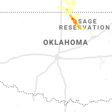


Cities Most Affected by Hail Storms of 8/12/2020
| Hail Size | Demographics of Zip Codes Affected | ||||||
|---|---|---|---|---|---|---|---|
| City | Count | Average | Largest | Pop Density | House Value | Income | Age |
| Geuda Springs, KS | 1 | 2.00 | 2.00 | 5 | $41k | $39.4k | 42.5 |
| Kaw City, OK | 1 | 1.75 | 1.75 | 32 | $68k | $31.8k | 48.8 |
| Burbank, OK | 1 | 1.75 | 1.75 | 4 | $44k | $27.8k | 44.3 |
| Hominy, OK | 1 | 1.75 | 1.75 | 12 | $42k | $25.0k | 37.9 |
Hail and Wind Damage Spotted on 8/12/2020
Filter by Report Type:Hail ReportsWind Reports
States Impacted
Nebraska, New Jersey, Delaware, Pennsylvania, Iowa, Kentucky, Tennessee, Georgia, Maryland, Wyoming, Alabama, North Carolina, Montana, South Dakota, Texas, Virginia, New Mexico, Kansas, OklahomaNebraska
| Local Time | Report Details |
|---|---|
| 7:04 AM CDT | Mesonet recorded a 59mph wind gus in red willow county NE, 60.5 miles NNE of Colby, KS |
| 6:36 PM MDT | Quarter sized hail reported near Sidney, NE, 65.1 miles N of Yuma, CO |
New Jersey
| Local Time | Report Details |
|---|---|
| 12:19 PM EDT | Several reports of tree limbs and wires down in moorestown. time estimated from rada in burlington county NJ, 71.6 miles SW of Brooklyn, NY |
| 12:34 PM EDT | Downed tree and wires near gilbert road in jacksonville. time estimated from rada in burlington county NJ, 60.8 miles SW of Brooklyn, NY |
| 12:43 PM EDT | Several reports of tree limbs and power lines down between willingboro and westampton township. time estimated from rada in burlington county NJ, 65 miles SW of Brooklyn, NY |
| 12:47 PM EDT | Several reports of tree limbs and wires near and north of mount laurel. time estimated from rada in burlington county NJ, 68.9 miles SW of Brooklyn, NY |
| 12:54 PM EDT | Downed tree and wires near pine street in brick township. time estimated from rada in ocean county NJ, 44.9 miles S of Brooklyn, NY |
| 12:56 PM EDT | Downed tree and wires near central avenue in brick township. time estimated from rada in ocean county NJ, 45 miles S of Brooklyn, NY |
| 12:56 PM EDT | Downed tree limbs and power lines near monmouth road and garden street in jacksonville. time estimated from rada in burlington county NJ, 63.4 miles SW of Brooklyn, NY |
| 1:01 PM EDT | Downed wires near mill street in mount holly. time estimated from rada in burlington county NJ, 63.6 miles SW of Brooklyn, NY |
| 1:05 PM EDT | Several reports of downed power lines south of lakewood township. time estimated from rada in ocean county NJ, 49 miles SSW of Brooklyn, NY |
| 1:14 PM EDT | Numerous reports of downed power lines in the pennsauken area. time estimated from rada in camden county NJ, 76.2 miles SW of Brooklyn, NY |
| 1:19 PM EDT | Several reports of wires down in the maple shade area. time estimated from rada in burlington county NJ, 73.5 miles SW of Brooklyn, NY |
| 1:19 PM EDT | Corrects previous tstm wnd dmg report from moorestown twp. several reports of tree limbs and wires down in moorestown. time estimated from rada in burlington county NJ, 71.6 miles SW of Brooklyn, NY |
| 1:30 PM EDT | Several reports of downed power lines in the silver ridge area. time estimated from rada in ocean county NJ, 51.6 miles SSW of Brooklyn, NY |
| 1:37 PM EDT | Several reports of power lines down in ellisburg. time estimated from rada in camden county NJ, 75.4 miles SW of Brooklyn, NY |
| 1:44 PM EDT | Several reports of tree limbs and wires down in in the cherry hill area. time estimated from rada in camden county NJ, 76 miles SW of Brooklyn, NY |
| 1:46 PM EDT | Downed tree and wires near lamp post lane in greentree. time estimated from rada in camden county NJ, 75.1 miles SW of Brooklyn, NY |
| 2:11 PM EDT | Reports of power lines down in the crestwood village area. time estimated from rada in ocean county NJ, 54.6 miles SSW of Brooklyn, NY |
| 2:16 PM EDT | Downed tree limbs and wires near chatsworth tuckerton road. time estimated from rada in burlington county NJ, 68.3 miles SSW of Brooklyn, NY |
| 2:19 PM EDT | Power lines down in haddon heights. time estimated from rada in camden county NJ, 79.6 miles SW of Brooklyn, NY |
| 2:35 PM EDT | Several reports of tree limbs and wires down in west deptford and woodbury. time estimated from rada in gloucester county NJ, 85.3 miles SW of Brooklyn, NY |
| 2:57 PM EDT | Several reports of wires down in the blackwood area. time estimated from rada in camden county NJ, 84 miles SW of Brooklyn, NY |
| 3:16 PM EDT | Several reports of power lines down near ancora and chesilhurst. time estimated from rada in camden county NJ, 81.6 miles SSW of Brooklyn, NY |
| 3:18 PM EDT | Downed power lines northwest of hammonton. time estimated from rada in camden county NJ, 84 miles SSW of Brooklyn, NY |
| 3:25 PM EDT | Large tree down on new st. time estimated from rada in gloucester county NJ, 84.4 miles ENE of Baltimore, MD |
| 4:03 PM EDT | Large tree limbs and branches (greater than 2 inches in diameter) downed at 165 west street in bergen county NJ, 13.7 miles N of Brooklyn, NY |
Delaware
| Local Time | Report Details |
|---|---|
| 1:19 PM EDT | Several reports of downed trees and wires in the cheswold area. time estimated from rada in kent county DE, 55.4 miles E of Baltimore, MD |
| 1:54 PM EDT | Several trees down on twaddell mill road. time estimated from rada in new castle county DE, 65.1 miles NE of Baltimore, MD |
| 2:04 PM EDT | Reports of downed tree limbs and wires near kilburn road and mount lebanon road. street flooding also reported. time estimated from rada in new castle county DE, 66.2 miles ENE of Baltimore, MD |
Pennsylvania
| Local Time | Report Details |
|---|---|
| 1:54 PM EDT | Large tree limbs on dutton mill road near cratin lane. time estimated from rada in chester county PA, 75.5 miles NE of Baltimore, MD |
| 2:00 PM EDT | With street flooding and several downed trees and power lines. time estimated from rada in chester county PA, 74.3 miles NE of Baltimore, MD |
| 2:10 PM EDT | Wind gusts estimated to 60 mph with several trees and branches downed. power lines also brought down with several traffic lights out. time estimated from rada in montgomery county PA, 70.8 miles WSW of Brooklyn, NY |
| 2:30 PM EDT | Trees and wires down near country club dr at e lancaster ave... near the downingtown country club. time estimated from rada in chester county PA, 70.6 miles NE of Baltimore, MD |
| 2:31 PM EDT | Tree down partially blocking boot rd near circle dr. time estimated from rada in chester county PA, 70.8 miles NE of Baltimore, MD |
| 2:38 PM EDT | Trees down on wires on bondsville rd at e fisherville rd. bondsville rd is closed due to downed trees... and is also flooded. time estimated from rada in chester county PA, 68.1 miles NE of Baltimore, MD |
| 2:38 PM EDT | Multiple reports of downed trees on and near route 30 near kings hwy. time estimated from rada in chester county PA, 66.1 miles NE of Baltimore, MD |
| 2:45 PM EDT | Water rescue on lincoln hwy at bailey r in chester county PA, 66.2 miles NE of Baltimore, MD |
| 2:54 PM EDT | Downed tree in wires near the intersection of brandywine creek road and green valley road. time estimated from rada in chester county PA, 63.6 miles NE of Baltimore, MD |
| 3:24 PM EDT | Downed tree in wires near church road and third street. time estimated from rada in chester county PA, 58.3 miles NE of Baltimore, MD |
| 3:29 PM EDT | Tree down blocking baltimore pike. time estimated from rada in chester county PA, 57.4 miles NE of Baltimore, MD |
| 3:33 PM EDT | Tree and wires down blocking church rd at polo rd near loch nairn golf links. time estimated from rada in chester county PA, 59.2 miles NE of Baltimore, MD |
Iowa
| Local Time | Report Details |
|---|---|
| 1:00 PM CDT | Storm damage reported in muscatine county IA, 43 miles SE of Cedar Rapids, IA |
Kentucky
| Local Time | Report Details |
|---|---|
| 1:15 PM CDT | Tree down...reported at 4000 sunnyside gotts warren county ky. time estimated using rada in warren county KY, 62.4 miles NNE of Nashville, TN |
Tennessee
| Local Time | Report Details |
|---|---|
| 1:24 PM CDT | Tree down on eastland ave near 16th and 17th st in davidson county TN, 2.3 miles ENE of Nashville, TN |
| 1:24 PM CDT | Power line down on greenwood ave in davidson county TN, 2.6 miles NE of Nashville, TN |
| 1:57 PM CDT | Twitter tspotter report of power lines down on madison street in clarksville in montgomery county TN, 41.8 miles NW of Nashville, TN |
| 2:40 PM CDT | Fence blown down and pea size hail reported in the blackman area in rutherford county TN, 25.2 miles SE of Nashville, TN |
Georgia
| Local Time | Report Details |
|---|---|
| 2:33 PM EDT | Power line down along s county line rd and melissa r in douglas county GA, 18.9 miles W of Atlanta, GA |
| 2:35 PM EDT | Tree down on power line along the 600 block of hwy 25 in bleckley county GA, 62.8 miles NNW of Douglas, GA |
| 3:31 PM EDT | Tree and powerlines down near the intersection of crestwood dr and farr r in fayette county GA, 22.7 miles SSW of Atlanta, GA |
| 3:34 PM EDT | Tree and powerline down blocking the roadway near intersection of hwy 92 and hickory r in fayette county GA, 19 miles SSW of Atlanta, GA |
| 4:10 PM EDT | Picture on social media of numerous trees down in yard of homeowner along old three notch r in catoosa county GA, 14 miles SSE of Chattanooga, TN |
| 4:10 PM EDT | Tree down along the 400 block of westbrook r in catoosa county GA, 16 miles SSE of Chattanooga, TN |
| 4:10 PM EDT | Tree down near the intersection of houston valley rd and bandy r in catoosa county GA, 17.9 miles SE of Chattanooga, TN |
| 4:15 PM EDT | Power line reported down on the 100th block of high falls r in spalding county GA, 36.2 miles SSE of Atlanta, GA |
| 5:33 PM EDT | A tree was reported down between mile marker 192 and 193 sb on interstate 75 just south of johnstonville roa in monroe county GA, 49.5 miles SSE of Atlanta, GA |
| 5:54 PM EDT | A tree was reported down in the 1700 block of carter av in muscogee county GA, 31.7 miles ESE of Auburn, AL |
| 7:33 PM EDT | Trees and power lines down around the east robinson ave and katherine street area. two homes reported to have damage from falling trees. time estimated from rada in columbia county GA, 13.1 miles W of Augusta, GA |
Maryland
| Local Time | Report Details |
|---|---|
| 2:38 PM EDT | Wind-blown debris forced lane restrictions on u.s. highway 1 near susquehanna river road. time estimated from rada in cecil county MD, 35.2 miles NE of Baltimore, MD |
| 4:40 PM EDT | Tree down on detached garage on the 700 block of prospect mill road in harford county MD, 24.5 miles NE of Baltimore, MD |
| 4:55 PM EDT | Tree down on wires blocking entire roadway of the 2500 block of shuresville road in harford county MD, 33.8 miles NE of Baltimore, MD |
| 5:00 PM EDT | Tree down near the intersection of shuresville road and conowingo road in harford county MD, 33.8 miles NE of Baltimore, MD |
| 5:00 PM EDT | Tree reported down on kintop road near eleanore driv in anne arundel county MD, 9.7 miles S of Baltimore, MD |
| 5:29 PM EDT | Trees down on power lines near beechwood road and bonnie branch roa in howard county MD, 9 miles WSW of Baltimore, MD |
| 5:30 PM EDT | Powerlines down near the intersection of bonnie branch road and ilchester road in howard county MD, 9 miles WSW of Baltimore, MD |
| 6:00 PM EDT | Tree on house on 4800 block of strathmore avenue. radar estimated tim in montgomery county MD, 31.5 miles WSW of Baltimore, MD |
| 6:10 PM EDT | Tree down on wires near the intersection of kernan drive and dogwood road in baltimore county MD, 6.1 miles WNW of Baltimore, MD |
| 6:45 PM EDT | Tree down on wires near the intersection of seneca road and esworthy road in montgomery county MD, 39.6 miles WSW of Baltimore, MD |
Wyoming
| Local Time | Report Details |
|---|---|
| 1:21 PM MDT | Measured at rock springs airpor in sweetwater county WY, 9 miles E of Rock Springs, WY |
| 4:05 PM MDT | Associated with high-based showers in the area in campbell county WY, 55.3 miles SSE of Gillette, WY |
| 5:00 PM MDT | Asos station klnd lander airpor in fremont county WY, 22.7 miles SW of Riverton, WY |
Alabama
| Local Time | Report Details |
|---|---|
| 2:50 PM CDT | Tree fell on a power line at beard st and fairbanks s in madison county AL, 60.7 miles E of Florence, AL |
| 2:50 PM CDT | Tree down at the nws huntsville offic in madison county AL, 58.5 miles E of Florence, AL |
| 6:23 PM CDT | Trees were blown down near wares ferry roa in montgomery county AL, 44.5 miles WSW of Auburn, AL |
| 6:27 PM CDT | Part of a large tree fell on a carport. this occurred near eastdale mal in montgomery county AL, 44.5 miles WSW of Auburn, AL |
| 6:33 PM CDT | Some damage along atlanta highway including restaurant signs blown out and blown dow in montgomery county AL, 44.8 miles WSW of Auburn, AL |
| 6:43 PM CDT | Meteorologist estimates winds of 60 mph and pea size hail near eastdale mal in montgomery county AL, 44.5 miles WSW of Auburn, AL |
| 6:48 PM CDT | Trees were blown down in the waters are in montgomery county AL, 37.5 miles WSW of Auburn, AL |
North Carolina
| Local Time | Report Details |
|---|---|
| 5:15 PM EDT | One tree down and outdoor furniture blown around. one mail box lost. also torrential rai in iredell county NC, 42.3 miles N of Charlotte, NC |
Montana
| Local Time | Report Details |
|---|---|
| 3:47 PM MDT | Storm damage reported in park county MT, 28.3 miles E of Bozeman, MT |
| 4:39 PM MDT | Storm damage reported in park county MT, 28.3 miles E of Bozeman, MT |
| 5:55 PM MDT | Storm damage reported in yellowstone county MT, 11.7 miles WNW of Billings, MT |
South Dakota
| Local Time | Report Details |
|---|---|
| 4:00 PM MDT | Siding blown off of trailer homes in oglala lakota county SD, 67.1 miles SSE of Rapid City, SD |
Texas
| Local Time | Report Details |
|---|---|
| 5:17 PM CDT | Recorded by the west texas mesone in armstrong county TX, 48.5 miles ESE of Amarillo, TX |
Virginia
| Local Time | Report Details |
|---|---|
| 7:32 PM EDT | Several trees down southwest of purcellville... including on tranquility rd and silcott springs rd in loudoun county VA, 61.8 miles W of Baltimore, MD |
New Mexico
| Local Time | Report Details |
|---|---|
| 6:30 PM MDT | Kabq aso in bernalillo county NM, 3.5 miles SSE of Albuquerque, NM |
Kansas
| Local Time | Report Details |
|---|---|
| 12:22 AM CDT | Hen Egg sized hail reported near Geuda Springs, KS, 41.2 miles SSE of Wichita, KS, delayed report. public report relayed via the cowley county em. time estimated based on radar. |
| 12:28 AM CDT | Half Dollar sized hail reported near Arkansas City, KS, 46 miles SSE of Wichita, KS, report relayed via cowley em. |
| 12:48 AM CDT | Quarter sized hail reported near Wichita, KS, 9.1 miles E of Wichita, KS, public report relayed via ksn. report based off picture submitted on social media. |
Oklahoma
| Local Time | Report Details |
|---|---|
| 1:35 AM CDT | Golf Ball sized hail reported near Kaw City, OK, 64 miles NW of Tulsa, OK, time estimated from radar. |
| 1:59 AM CDT | Golf Ball sized hail reported near Burbank, OK, 55.4 miles NW of Tulsa, OK |
| 2:40 AM CDT | Golf Ball sized hail reported near Hominy, OK, 28.5 miles NW of Tulsa, OK |
| 2:57 AM CDT | Quarter sized hail reported near Skiatook, OK, 15.8 miles NNW of Tulsa, OK, also 60 mph winds reported. |
| 3:24 AM CDT | Storm damage reported in tulsa county OK, 7 miles ENE of Tulsa, OK |
| 3:30 AM CDT | Storm damage reported in tulsa county OK, 4.3 miles ESE of Tulsa, OK |
| 3:37 AM CDT | Several large branches down in the vicinity of 11th and sheridan. time estimated from rada in tulsa county OK, 7 miles E of Tulsa, OK |
| 3:54 AM CDT | Storm damage reported in tulsa county OK, 15.1 miles SSE of Tulsa, OK |
Connect with Interactive Hail Maps