

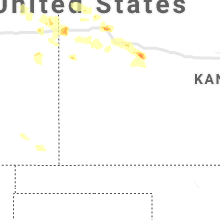
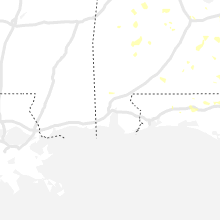
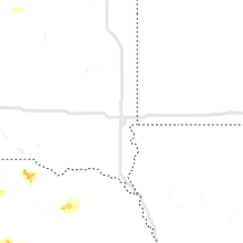
Hail Map for Tuesday, August 11, 2020

Number of Impacted Households on 8/11/2020
0
Impacted by 1" or Larger Hail
0
Impacted by 1.75" or Larger Hail
0
Impacted by 2.5" or Larger Hail
Square Miles of Populated Area Impacted on 8/11/2020
0
Impacted by 1" or Larger Hail
0
Impacted by 1.75" or Larger Hail
0
Impacted by 2.5" or Larger Hail


Cities Most Affected by Hail Storms of 8/11/2020
| Hail Size | Demographics of Zip Codes Affected | ||||||
|---|---|---|---|---|---|---|---|
| City | Count | Average | Largest | Pop Density | House Value | Income | Age |
| Oakley, KS | 2 | 2.50 | 2.50 | 5 | $57k | $32.4k | 45.3 |
| Sharon Springs, KS | 2 | 1.88 | 2.00 | 1 | $47k | $34.4k | 46.0 |
| Hayes, SD | 1 | 1.75 | 1.75 | 1 | $34k | $31.3k | 44.3 |
| Scenic, SD | 1 | 1.75 | 1.75 | 0 | $17k | $31.8k | 48.8 |
| Hot Springs, SD | 1 | 1.75 | 1.75 | 11 | $63k | $30.3k | 50.7 |
Hail and Wind Damage Spotted on 8/11/2020
Filter by Report Type:Hail ReportsWind Reports
States Impacted
South Dakota, Georgia, Kansas, Florida, Colorado, Alabama, South Carolina, Wyoming, Arkansas, Mississippi, Nebraska, New York, Vermont, North Dakota, Virginia, Maine, Nevada, Montana, TexasSouth Dakota
| Local Time | Report Details |
|---|---|
| 9:15 AM MDT | Quarter sized hail reported near Milesville, SD, 63.7 miles W of Pierre, SD |
| 11:31 AM MDT | Half Dollar sized hail reported near Midland, SD, 49.8 miles W of Pierre, SD, inch of rain |
| 11:55 AM MDT | Golf Ball sized hail reported near Hayes, SD, 39.1 miles W of Pierre, SD, mostly golf balls but some larger sized stones. time estimated via radar. |
| 11:56 AM MDT | Damage to siding from hail and winds. radar estimated tim in stanley county SD, 39.4 miles WNW of Pierre, SD |
| 4:35 PM MDT | Storm damage reported in oglala lakota county SD, 82.1 miles SSE of Rapid City, SD |
| 4:45 PM MDT | Storm damage reported in oglala lakota county SD, 80.9 miles SSE of Rapid City, SD |
| 5:40 PM MDT | Ping Pong Ball sized hail reported near Hot Springs, SD, 44.7 miles SSW of Rapid City, SD |
| 5:43 PM MDT | Quarter sized hail reported near Hot Springs, SD, 44.8 miles SSW of Rapid City, SD, along with heavy rain |
| 5:45 PM MDT | Ping Pong Ball sized hail reported near Hot Springs, SD, 46.7 miles SSW of Rapid City, SD, photo shows hail stones of around ping pong sized. time estimated from radar. |
| 5:46 PM MDT | Golf Ball sized hail reported near Hot Springs, SD, 45.9 miles SSW of Rapid City, SD |
| 5:56 PM MDT | Quarter sized hail reported near Hot Springs, SD, 45.7 miles S of Rapid City, SD |
| 7:05 PM MDT | Golf Ball sized hail reported near Scenic, SD, 37.7 miles ESE of Rapid City, SD, marble to golf ball size. lasted about 10 min. |
| 7:29 PM MDT | Ping Pong Ball sized hail reported near New Underwood, SD, 30.1 miles ESE of Rapid City, SD |
| 8:30 PM MDT | Storm damage reported in perkins county SD, 113.3 miles SW of Bismarck, ND |
| 11:29 PM MDT | Mesonet station 205 mclaughlin (sddot in corson county SD, 66.3 miles S of Bismarck, ND |
| 11:40 PM MDT | Mesonet station mhts2 mclaughlin 2 se (sd mesonet in corson county SD, 69.4 miles S of Bismarck, ND |
| 12:06 AM MDT | Mesonet station grrs2 bullhead 10 in corson county SD, 83.7 miles S of Bismarck, ND |
| 1:53 AM CDT | Storm damage reported in mcpherson county SD, 55.3 miles WNW of Aberdeen, SD |
| 4:00 AM CDT | Storm damage reported in day county SD, 34 miles E of Aberdeen, SD |
| 4:50 AM CDT | Mesonet station 55 summit (sddot in roberts county SD, 69.7 miles WNW of Montevideo, MN |
Georgia
| Local Time | Report Details |
|---|---|
| 1:38 PM EDT | Tree fell on power lin in gadsden county FL, 35.1 miles WNW of Tallahassee, FL |
| 4:25 PM EDT | Tree dow in thomas county GA, 32.9 miles NNE of Tallahassee, FL |
| 6:01 PM EDT | A tree was reported down near the intersection of lagrange street and woodard roa in meriwether county GA, 47.3 miles NE of Auburn, AL |
| 6:15 PM EDT | A tree was reported down near the intersection of chipley highway south just behing the georgia pacific buildin in meriwether county GA, 42.7 miles ENE of Auburn, AL |
| 6:17 PM EDT | A tree was reported down near the intersection of old duran road and ogletree roa in meriwether county GA, 49 miles ENE of Auburn, AL |
| 6:25 PM EDT | Several trees were reported down near the intersection of herbert russell road and mullins cemetary roa in meriwether county GA, 45 miles ENE of Auburn, AL |
| 6:30 PM EDT | Tree down near the intersection of hwy 41 s and wiggins roa in marion county GA, 62.5 miles ESE of Auburn, AL |
| 7:17 PM EDT | Tree down near the intersection of ebenezer rd and marvin murphy r in schley county GA, 72.4 miles ESE of Auburn, AL |
| 7:22 PM EDT | Tree down near intersection of hwy 26 and concord church roa in schley county GA, 71.7 miles ESE of Auburn, AL |
| 7:22 PM EDT | Quarter sized hail reported near Ellaville, GA, 72.2 miles ESE of Auburn, AL, approximately one inch hail via social media pictures on the western side of ellaville. |
| 8:01 PM EDT | Social media post indicated a tree down on the road near the intersection of niles avenue and east 15th stree in liberty county GA, 32.4 miles WSW of Savannah, GA |
| 8:04 PM EDT | Large limb reported down near the intersection of south main and general screven way. time estimated from radar dat in liberty county GA, 34.2 miles WSW of Savannah, GA |
| 8:08 PM EDT | Power line down on the 600 block of mcdowell road. time estimated from radar dat in liberty county GA, 35.1 miles WSW of Savannah, GA |
| 8:08 PM EDT | Power line and tree limb down near the intersection of pineland avenue and honey ridge lane. time estimated from radar dat in liberty county GA, 35.9 miles WSW of Savannah, GA |
| 8:08 PM EDT | Social media pictures indicated roofing material from a business near the intersection of pineland and elma g mile parkwa in liberty county GA, 35.6 miles WSW of Savannah, GA |
Kansas
| Local Time | Report Details |
|---|---|
| 12:40 PM CDT | Quarter sized hail reported near Colby, KS, 2 miles SSW of Colby, KS, 1 inch hail reported via twitter at i-70 and k25. |
| 7:46 PM MDT | Quarter sized hail reported near Sharon Springs, KS, 51.1 miles SW of Colby, KS, trained spotter observed nickel to quarter sized hail ongoing. |
| 7:50 PM MDT | Hen Egg sized hail reported near Sharon Springs, KS, 51.1 miles SW of Colby, KS |
| 7:50 PM MDT | Golf Ball sized hail reported near Sharon Springs, KS, 51.1 miles SW of Colby, KS, report of estimated golf ball size hail received via social media. |
| 7:53 PM MDT | Ping Pong Ball sized hail reported near Sharon Springs, KS, 51.1 miles SW of Colby, KS, trained spotter observed ongoing ping pong ball sized hail. |
| 12:40 AM CDT | Tennis Ball sized hail reported near Oakley, KS, 21.2 miles SSE of Colby, KS, corrects previous hail report from oakley. report via facebook of a few tennis ball size hailstones mixed with nickel size hail time based on radar. |
| 1:00 AM CDT | Tennis Ball sized hail reported near Oakley, KS, 21.2 miles SSE of Colby, KS, report via facebook of a few tennis ball size hailstones mixed with nickel size hail. |
| 3:20 AM CDT | Mesonet site reports a 58mph wind gus in cheyenne county KS, 47.8 miles WNW of Colby, KS |
Florida
| Local Time | Report Details |
|---|---|
| 1:45 PM EDT | Tree in roadwa in gadsden county FL, 39.2 miles WNW of Tallahassee, FL |
| 1:47 PM EDT | 4 big tree branches were broke in gilchrist county FL, 81.4 miles SW of Jacksonville, FL |
| 2:25 PM EDT | Damage to batting cage... bleachers blown over... and one tree uprooted at lakewood ranch park. time estimated by radar. winds estimated 45 to 50 mp in manatee county FL, 9 miles ESE of Bradenton, FL |
| 2:05 PM CDT | Several trees reported dow in jackson county FL, 63.4 miles NW of Tallahassee, FL |
| 3:15 PM EDT | Tree down blocking both lanes of colbert lane at waterfront park road. radar estimated tim in flagler county FL, 60.9 miles SSE of Jacksonville, FL |
| 2:30 PM CDT | Several trees reported dow in jackson county FL, 47.8 miles WNW of Tallahassee, FL |
| 2:30 PM CDT | Tree dow in jackson county FL, 59.9 miles WNW of Tallahassee, FL |
| 3:00 PM CDT | One tree down and multiple power lines dow in washington county FL, 56.3 miles ENE of Miramar Beach, FL |
| 3:15 PM CDT | Tree down in fountain. reported via social medi in bay county FL, 56.6 miles E of Miramar Beach, FL |
| 3:15 PM CDT | Tree dow in holmes county FL, 46.2 miles NE of Miramar Beach, FL |
| 3:20 PM CDT | Trees fell across roadways in the porter lake area. reported via social medi in washington county FL, 49.7 miles E of Miramar Beach, FL |
| 5:21 PM EDT | Multiple trees down and snapped near francis road. radar estimated time. relayed from social medi in duval county FL, 5.1 miles NW of Jacksonville, FL |
| 5:23 PM EDT | Tree fell on a minivan near the intersection of forest st and stockton st. driver sustained injurie in duval county FL, 2 miles W of Jacksonville, FL |
Colorado
| Local Time | Report Details |
|---|---|
| 12:00 PM MDT | Microburst at about 12:00pm today... downed tree branches and light sprinkles (short duration) and about an hour long power outag in denver county CO, 6.2 miles SE of Denver, CO |
| 12:05 PM MDT | Blue spruce tree fell onto a car via high winds. no rain reported. likely dry microburs in arapahoe county CO, 6.4 miles SE of Denver, CO |
| 3:15 PM MDT | Storm damage reported in yuma county CO, 9 miles SSE of Yuma, CO |
| 3:45 PM MDT | Storm damage reported in yuma county CO, 24.4 miles ESE of Yuma, CO |
| 5:10 PM MDT | Quarter sized hail reported near Burlington, CO, 49.5 miles SSE of Yuma, CO |
| 5:15 PM MDT | Quarter sized hail reported near Burlington, CO, 49.9 miles SSE of Yuma, CO, time estimated by radar. |
Alabama
| Local Time | Report Details |
|---|---|
| 1:50 PM CDT | Mgm 51kts 185 in montgomery county AL, 56.9 miles ENE of Camden, AL |
| 1:55 PM CDT | Tree blocking roadwa in houston county AL, 73.8 miles NW of Tallahassee, FL |
| 2:07 PM CDT | Tree in roadwa in houston county AL, 75.7 miles NE of Miramar Beach, FL |
| 3:00 PM CDT | A few trees were blown down near north blv in montgomery county AL, 46.7 miles WSW of Auburn, AL |
| 3:12 PM CDT | Trees down near highway 2 in pike county AL, 66.8 miles SW of Auburn, AL |
| 3:24 PM CDT | A few trees were blown down on cr 7714 near the airpor in pike county AL, 58 miles SSW of Auburn, AL |
| 3:30 PM CDT | A few trees blown down near us highway 23 in pike county AL, 56.6 miles SSW of Auburn, AL |
| 4:14 PM CDT | Trees and power lines were blown down and some roadways were impassable. the downed trees were on chatham road... sr 68... bice road... and highway 231. one tree has fa in coosa county AL, 44 miles SE of Birmingham, AL |
| 4:48 PM CDT | A large tree was blown down on pace roa in clay county AL, 50.8 miles NNW of Auburn, AL |
| 5:45 PM CDT | 1 large tree down with 53 mph gust reported. dime-size hail also observe in jefferson county AL, 15.9 miles WSW of Birmingham, AL |
| 6:14 PM CDT | A tree and power lines were blown down on hargrove roa in tuscaloosa county AL, 47.9 miles WSW of Birmingham, AL |
| 6:19 PM CDT | A tree fell on a home on skyline driv in tuscaloosa county AL, 48.4 miles WSW of Birmingham, AL |
| 7:19 PM CDT | Corrects previous tstm wnd dmg report from 1 wsw mcfarland mall. a tree fell on a home on skyline driv in tuscaloosa county AL, 48.4 miles WSW of Birmingham, AL |
| 7:19 PM CDT | Corrects previous tstm wnd dmg report from 1 w university mall. a tree and power lines were blown down on hargrove roa in tuscaloosa county AL, 47.9 miles WSW of Birmingham, AL |
| 7:30 PM CDT | Trees reported down at multiple locations in mobile... including on rebecca drive and stanton road... on mobile street... crescent drive west and old military... cotton in mobile county AL, 3.6 miles NW of Mobile, AL |
South Carolina
| Local Time | Report Details |
|---|---|
| 3:15 PM EDT | 911 call center reported down tree across roadway. time estimated by rada in oconee county SC, 25.5 miles W of Greenville, SC |
| 3:30 PM EDT | 911 call center reported down power lines. time estimated by rada in oconee county SC, 24.7 miles WSW of Greenville, SC |
| 3:40 PM EDT | 911 call center reported down power lines. time estimated by rada in oconee county SC, 22.1 miles WSW of Greenville, SC |
| 3:40 PM EDT | Trained spotter reported multiple businesses had damaged sliding doors. time estimated by rada in oconee county SC, 24.2 miles WSW of Greenville, SC |
| 3:42 PM EDT | 911 call center reported multiple trees and power lines down. time estimated by rada in oconee county SC, 19.1 miles WSW of Greenville, SC |
Wyoming
| Local Time | Report Details |
|---|---|
| 1:18 PM MDT | Quarter sized hail reported near Cheyenne, WY, 58.2 miles ESE of Laramie, WY |
Arkansas
| Local Time | Report Details |
|---|---|
| 4:16 PM CDT | Power pole blown over onto parked cars on military rd in bento in saline county AR, 21.3 miles SW of Little Rock, AR |
| 4:27 PM CDT | Large tree was blown down on peeler bend road... blocking the roadway. several power lines were also downe in saline county AR, 24.1 miles WSW of Little Rock, AR |
Mississippi
| Local Time | Report Details |
|---|---|
| 5:50 PM CDT | Tree down along hwy 1 in clarke county MS, 69.5 miles W of Camden, AL |
| 8:30 PM CDT | Tree down on co rd 14 in clarke county MS, 80.8 miles W of Camden, AL |
| 8:35 PM CDT | Social media picture of a tree down in the zero communit in lauderdale county MS, 80.9 miles S of Starkville, MS |
| 8:35 PM CDT | Tree down along co rd 44 in clarke county MS, 78.2 miles W of Camden, AL |
| 8:51 PM CDT | Tree down on power line in lauderdale county MS, 78 miles WNW of Camden, AL |
Nebraska
| Local Time | Report Details |
|---|---|
| 4:57 PM MDT | Half Dollar sized hail reported near Imperial, NE, 58.8 miles ENE of Yuma, CO |
| 4:57 PM MDT | Storm damage reported in chase county NE, 58.8 miles ENE of Yuma, CO |
| 2:26 AM MDT | Thunderstorm outflow in chase county NE, 62.6 miles SW of North Platte, NE |
New York
| Local Time | Report Details |
|---|---|
| 7:59 PM EDT | Tree down across road near county rd 4 and sand hill rd blocking both lanes of traffic in otsego county NY, 65 miles SE of Syracuse, NY |
| 8:04 PM EDT | Tree down on county rd 42 in otsego county NY, 51.6 miles WSW of Schenectady, NY |
| 9:16 PM EDT | Tree down on brown rd in broome county NY, 46.2 miles N of Scranton, PA |
Vermont
| Local Time | Report Details |
|---|---|
| 8:03 PM EDT | Small tree blown into a house on luck stree in chittenden county VT, 3.2 miles NNW of Burlington, VT |
| 8:05 PM EDT | Right lane southbound on i-89 briefly closed near the winooski bridge for a downed tre in chittenden county VT, 2.7 miles NE of Burlington, VT |
| 8:05 PM EDT | 12 inch diameter trees blown dow in chittenden county VT, 2 miles NE of Burlington, VT |
| 8:10 PM EDT | Tree down along u.s. route in chittenden county VT, 2.2 miles SW of Burlington, VT |
North Dakota
| Local Time | Report Details |
|---|---|
| 6:14 PM MDT | Quarter sized hail reported near Marmarth, ND, 93.1 miles E of Miles City, MT, 30-40 mph winds accompanied the hail. also measured 3.5 inches of rain in one hour. most of the hail was smaller... with the larger stones the size of a quarter. the la |
| 6:26 PM MDT | 2 e grassy butte ndawn station. corn flattened in the are in mckenzie county ND, 55.7 miles SSE of Williston, ND |
| 6:55 PM MDT | Very heavy rainfall with the wind creating visibility of 1-2 city block in bowman county ND, 118.8 miles E of Miles City, MT |
| 7:15 PM MDT | Bowman airport observed wind gus in bowman county ND, 116.8 miles E of Miles City, MT |
| 7:30 PM MDT | Storm damage reported in harding county SD, 112.6 miles ESE of Miles City, MT |
| 7:45 PM MDT | One inch of rain with pea size hail accompanied the win in dunn county ND, 80 miles SSE of Williston, ND |
| 7:55 PM MDT | Winds severely reduced visibility with blowing dust and then very heavy rain. relayed through social medi in adams county ND, 114.8 miles WSW of Bismarck, ND |
| 8:13 PM MDT | Measured thunderstorm wind gust at hettinger airport. strong winds lasted 10-15 minute in adams county ND, 104.9 miles WSW of Bismarck, ND |
| 8:18 PM MDT | Hettinger airport observatio in adams county ND, 104.9 miles WSW of Bismarck, ND |
| 9:00 PM MDT | Remote automated weather station (raws) observation. williams lookout raw in hettinger county ND, 68.3 miles WSW of Bismarck, ND |
Virginia
| Local Time | Report Details |
|---|---|
| 8:15 PM EDT | Multiple trees down in rockingham county VA, 69.4 miles SE of Elkins, WV |
Maine
| Local Time | Report Details |
|---|---|
| 8:20 PM EDT | 18 inch diameter poplar tree blocking the entire roa in aroostook county ME, 39.4 miles NW of Caribou, ME |
| 8:20 PM EDT | 18 inch diameter poplar tree blocking the entire roa in aroostook county ME, 39.4 miles NW of Caribou, ME |
Nevada
| Local Time | Report Details |
|---|---|
| 5:41 PM PDT | Mesonet station gcrnv 5.1 e golconda (nv dot in humboldt county NV, 18.1 miles E of Winnemucca, NV |
| 5:41 PM PDT | Mesonet station gcsnv 5.1 e golconda (nv dot in humboldt county NV, 18.4 miles ESE of Winnemucca, NV |
| 6:59 PM PDT | Mesonet station brln2 barrel spring in washoe county NV, 28.4 miles SE of Lakeview, OR |
Montana
| Local Time | Report Details |
|---|---|
| 8:04 PM MDT | Measured gust in yellowstone county MT, 18 miles NE of Billings, MT |
Texas
| Local Time | Report Details |
|---|---|
| 11:20 PM CDT | Measured by the texas tech university west texas mesonet in hale county TX, 41.4 miles NNE of Lubbock, TX |
Connect with Interactive Hail Maps