

Hail Map for Saturday, August 20, 2011

Number of Impacted Households on 8/20/2011
0
Impacted by 1" or Larger Hail
0
Impacted by 1.75" or Larger Hail
0
Impacted by 2.5" or Larger Hail
Square Miles of Populated Area Impacted on 8/20/2011
0
Impacted by 1" or Larger Hail
0
Impacted by 1.75" or Larger Hail
0
Impacted by 2.5" or Larger Hail


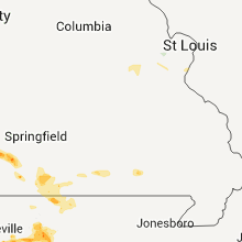


Cities Most Affected by Hail Storms of 8/20/2011
| Hail Size | Demographics of Zip Codes Affected | ||||||
|---|---|---|---|---|---|---|---|
| City | Count | Average | Largest | Pop Density | House Value | Income | Age |
| Aurora, MO | 2 | 2.25 | 2.75 | 75 | $62k | $27.4k | 39.7 |
| Crane, MO | 1 | 2.50 | 2.50 | 42 | $59k | $30.0k | 40.0 |
| Freistatt, MO | 1 | 1.75 | 1.75 | 0 | $0k | $0.0k | 46.1 |
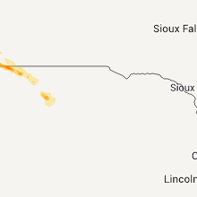
| Kilgore, NE | 1 | 1.75 | 1.75 | 0 | $30k | $28.9k | 44.8 |
Hail and Wind Damage Spotted on 8/20/2011
Filter by Report Type:Hail ReportsWind Reports
States Impacted
Missouri, Wisconsin, Illinois, Michigan, Tennessee, Georgia, Maine, Mississippi, South Carolina, Louisiana, Texas, Arkansas, Alabama, North Carolina, Colorado, Pennsylvania, NebraskaMissouri
| Local Time | Report Details |
|---|---|
| 12:00 PM UTC | Trees blown onto power line in phelps county MO, 25.1 miles NNW of Salem, MO |
| 5:40 PM CDT | Half Dollar sized hail reported near Pierce City, MO, 37.6 miles WSW of Springfield, MO, public reported half dollar size hail at the massie super stop gas station. |
| 5:46 PM CDT | Golf Ball sized hail reported near Freistatt, MO, 36 miles WSW of Springfield, MO, media relayed public report of golfball size hail. had another public call of golfball size hail on i-44 in the same area. |
| 6:06 PM CDT | Quarter sized hail reported near Aurora, MO, 28.8 miles SW of Springfield, MO |
| 6:15 PM CDT | Golf Ball sized hail reported near Aurora, MO, 28.8 miles SW of Springfield, MO, media relayed report of golfball size hail |
| 6:22 PM CDT | Baseball sized hail reported near Aurora, MO, 28.8 miles SW of Springfield, MO, baseball size hail knocked out sky lights at the walmart |
| 6:23 PM CDT | Tennis Ball sized hail reported near Crane, MO, 25.5 miles SW of Springfield, MO, fire chief reported tennis ball size hail |
| 12:10 AM UTC | Trees down just east of forsyth in taney county MO, 37.7 miles SSE of Springfield, MO |
| 12:25 AM UTC | Storm damage reported in taney county MO, 38.9 miles SSE of Springfield, MO |
| 12:25 AM UTC | Power pole down in taney county MO, 40.8 miles S of Springfield, MO |
Wisconsin
| Local Time | Report Details |
|---|---|
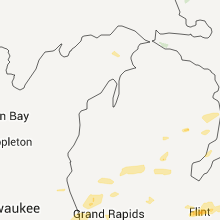
| 8:10 AM CDT | Quarter sized hail reported near Beloit, WI, 39.6 miles SSE of Madison, WI, pea to quarter size hail. accumulated up to 6 inches. time estimated. |
| 8:10 AM CDT | Half Dollar sized hail reported near Beloit, WI, 38.4 miles SSE of Madison, WI, quarter to half dollar sized hail. the wind driven hail shredded leaves off of the trees. |
Illinois
| Local Time | Report Details |
|---|---|
| 1:26 PM UTC | Trees down. size unknown at this tim in winnebago county IL, 45.6 miles SSE of Madison, WI |
| 8:35 AM CDT | Quarter sized hail reported near Roscoe, IL, 46.4 miles SSE of Madison, WI, cocorahs observer. |
| 2:40 PM UTC | Delayed report. burst of wind between 940 am and 942 am resulting in multiple large tree limbs dow in mchenry county IL, 45.1 miles WNW of Chicago, IL |
| 3:04 PM UTC | Delayed report.several trees and tree limbs dow in lake county IL, 29.8 miles NW of Chicago, IL |
| 3:08 PM UTC | Numerous six to twelve inch tree branches downed in the are in kane county IL, 43.4 miles W of Chicago, IL |
| 3:40 PM UTC | Delayed report. power lines downed...igniting a gas fir in cook county IL, 12.1 miles NNW of Chicago, IL |
| 1:10 AM UTC | Barn blown apart with debris in trees and power lines. 1 mile east of rt. 40 near camp grove road. time estimate in marshall county IL, 26.8 miles N of Peoria, IL |
Michigan
| Local Time | Report Details |
|---|---|
| 5:15 PM UTC | Tree and limb damage in riverside park between coit avenue and knapp street. two foot diameter limbs down. time estimated by rada in kent county MI, 2.3 miles N of Grand Rapids, MI |
| 5:40 PM UTC | Unhealthy 3 foot diameter tree is down and blocking the byrne rd between 5 mile and 6 mile. time is estimate in kent county MI, 16.3 miles ENE of Grand Rapids, MI |
| 5:48 PM UTC | A two inch diameter and healthy 35 foot long 2 inch diameter branch is blown down. time is approximat in kent county MI, 13.9 miles ENE of Grand Rapids, MI |
| 5:59 PM UTC | Wires down in burton heights due to win in kent county MI, 0.4 miles S of Grand Rapids, MI |
| 6:00 PM UTC | 35 foot...2 inch diameter healthy branch dow in kent county MI, 17 miles E of Grand Rapids, MI |
| 6:01 PM UTC | Spotter estimated wind gusts in the 50 to 60 mph range. some small branches have come dow in eaton county MI, 49.2 miles SE of Grand Rapids, MI |
| 6:03 PM UTC | Tree down on power and cable lines on sweet street n in kent county MI, 0.4 miles S of Grand Rapids, MI |
| 6:26 PM UTC | Central dispatch reports numerous trees down across forest township in genesee county MI, 13.8 miles NE of Flint, MI |
| 6:40 PM UTC | Numerous trees down...e ave and poorman rds...lynch and pine lake rds... and smith and w driv in calhoun county MI, 50.4 miles SE of Grand Rapids, MI |
| 6:45 PM UTC | Emergency manager reports a couple pine trees have been blown down along with some power lines. branches are down as wel in clinton county MI, 46.3 miles W of Flint, MI |
| 6:55 PM UTC | Storm damage reported in saginaw county MI, 42.6 miles NNW of Flint, MI |
| 7:03 PM UTC | 3 inch diameter tree branches down in saginaw county MI, 24.9 miles WNW of Flint, MI |
| 7:28 PM UTC | Power line snapped in half in genesee county MI, 10.4 miles NNE of Flint, MI |
| 7:44 PM UTC | 2 inch diameter tree limbs down in livingston county MI, 21.3 miles SSW of Flint, MI |
| 8:13 PM UTC | Central dispatch reported trees down in livingston county MI, 41 miles SSW of Flint, MI |
| 8:18 PM UTC | Trees and wires down in livingston county MI, 39.1 miles S of Flint, MI |
| 8:25 PM UTC | Wires down in green oak township in livingston county MI, 38 miles S of Flint, MI |
| 8:50 PM UTC | Storm damage reported in oakland county MI, 38.8 miles SSE of Flint, MI |
| 8:50 PM UTC | Dozens of large branches and trees down in oakland county MI, 42.6 miles SSE of Flint, MI |
| 8:50 PM UTC | Minor structural damage to greenhouses in oakland county MI, 36.5 miles SSE of Flint, MI |
| 8:52 PM UTC | 3 to 4 inch diameter trees on house in oakland county MI, 37 miles SSE of Flint, MI |
| 8:54 PM UTC | Wires reported down in oakland county MI, 44.2 miles SE of Flint, MI |
| 8:58 PM UTC | 5 inch diameter tree limbs down in oakland county MI, 43.3 miles SE of Flint, MI |
| 9:10 PM UTC | Storm damage reported in macomb county MI, 48.6 miles SE of Flint, MI |
| 9:15 PM UTC | Storm damage reported in macomb county MI, 51.3 miles SE of Flint, MI |
Tennessee
| Local Time | Report Details |
|---|---|
| 5:15 PM UTC | A few trees were knocked down in the town of lakeland. 4 or 5 power poles were down along evergreen street near city hal in shelby county TN, 19.1 miles ENE of Memphis, TN |
| 12:36 PM CDT | Quarter sized hail reported near Collierville, TN, 21.8 miles ESE of Memphis, TN, quarter size hail near raleigh lagrange and collierville arlington road. |
| 7:35 AM UTC | Numerous reports of trees blown down in the clarksville are in montgomery county TN, 41.8 miles NW of Nashville, TN |
| 8:10 AM UTC | Wsmv-tv reported a gas station awning was damaged at i-24 exit 19. time estimate in robertson county TN, 26.5 miles NW of Nashville, TN |
| 10:15 AM UTC | Emergency mngr reported multiple trees down and several hundred without power county-wide due to high wind in davidson county TN, 0.2 miles NNW of Nashville, TN |
Georgia
| Local Time | Report Details |
|---|---|
| 5:30 PM UTC | Fayette county emergency management reported around a dozen trees blown down in the area of tyrone road... adams road and dogwood trail. falling trees brought down powe in fayette county GA, 21.9 miles SSW of Atlanta, GA |
| 5:50 PM UTC | Local news reported about 10 trees down along buford highway in bufor in gwinnett county GA, 34.1 miles NE of Atlanta, GA |
| 5:50 PM UTC | Fayette county emergency management reported around a dozen trees blown down in the area of tyrone road... adams road and dogwood trail. falling trees brought down powe in fayette county GA, 21.9 miles SSW of Atlanta, GA |
| 6:35 PM UTC | Wet microburst downed 10 trees...some very large...as well as numerous limbs near jason ct. patio furniture was blown approx a dozen feet. damaged area isolated to arou in henry county GA, 27.3 miles SE of Atlanta, GA |
| 7:23 PM UTC | Large tree down over johnson street near west jones avenue. time estimated by rada in bulloch county GA, 48.3 miles WNW of Savannah, GA |
| 7:55 PM UTC | Barrow county 911 reported a few trees down on power lines in the area around mulberry and rockwell church road in barrow county GA, 44 miles ENE of Atlanta, GA |
| 8:05 PM UTC | Large tree limbs were blown down and were blocking route 119 near effingham county high schoo in effingham county GA, 23.6 miles NW of Savannah, GA |
| 8:15 PM UTC | Tree down on ardmore oaky road. time estimated by rada in effingham county GA, 34.7 miles NNW of Savannah, GA |
| 8:24 PM UTC | Trees and power lines down on clyo shawnee road and springfield road. time estimated by rada in effingham county GA, 31.1 miles NNW of Savannah, GA |
Maine
| Local Time | Report Details |
|---|---|
| 1:55 PM EDT | Quarter sized hail reported near Hampden, ME, 5.5 miles SW of Bangor, ME, quater sized hail along western avenue. |
| 6:00 PM UTC | Large tree branch fell on a power line causing a fir in penobscot county ME, 5.5 miles SW of Bangor, ME |
Mississippi
| Local Time | Report Details |
|---|---|
| 6:30 PM UTC | Power is also out...spotter was not sure if power lines were dow in marshall county MS, 43.3 miles SE of Memphis, TN |
| 1:30 PM CDT | Half Dollar sized hail reported near Holly Springs, MS, 43.3 miles SE of Memphis, TN, quarter to half dollar size hail in the town of holly springs. |
| 6:55 PM UTC | 4 inch limbs down at the intersection of cr 148 and cr 102 just north of the oxford airpor in lafayette county MS, 61.9 miles SSE of Memphis, TN |
| 8:25 PM UTC | Numerous reports of trees down in the ce in grenada county MS, 61.4 miles WNW of Starkville, MS |
| 8:25 PM UTC | Tree fell on a house on kershaw street. house sustained bad damag in grenada county MS, 61.4 miles WNW of Starkville, MS |
| 10:00 PM UTC | A couple trees and a power line were down in madison county MS, 20.8 miles NNW of Jackson, MS |
| 10:22 PM UTC | A couple trees and a power line down in madison county MS, 19.6 miles NW of Jackson, MS |
South Carolina
| Local Time | Report Details |
|---|---|
| 8:00 PM UTC | Volunteer fire fighter reports several trees down and damage to an old tobacco barn and metal shed near mcgee and azalea rd near coward. also tree down on a house along in florence county SC, 55.4 miles NNE of Charleston, SC |
| 8:05 PM UTC | Several limbs down on cedar creek rd near yogi bear campground in lexington county SC, 47.2 miles ENE of Augusta, GA |
| 9:16 PM UTC | Tri-county electric reported outages due to downed power line in calhoun county SC, 55.5 miles NW of Charleston, SC |
| 10:01 PM UTC | Sc highway patrol reports a tree down near the intersection of i-26 and old gilliard roa in dorchester county SC, 17.7 miles WSW of Charleston, SC |
| 11:09 PM UTC | Highway patrol reported a tree down along highway 66 two miles west of the elementary schoo in newberry county SC, 59.4 miles ESE of Greenville, SC |
Louisiana
| Local Time | Report Details |
|---|---|
| 8:25 PM UTC | Tree down across hwy 520 near wade correctional cente in claiborne county LA, 51.5 miles ENE of Shreveport, LA |
| 9:25 PM UTC | Roof blown off a building in homer and numerous trees down throughout the are in claiborne county LA, 44.3 miles ENE of Shreveport, LA |
| 11:00 PM UTC | Trees and powerlines down in bossier county LA, 27.2 miles N of Shreveport, LA |
| 1:00 AM UTC | Trees and powerlines down on philpot roa in ouachita county LA, 28.8 miles SSW of Bastrop, LA |
Texas
| Local Time | Report Details |
|---|---|
| 8:30 PM UTC | Trees and powerlines down on gatlin road and fm 2879 near lake deerwoo in harrison county TX, 47.5 miles WNW of Shreveport, LA |
| 10:35 PM UTC | Trees and powerlines down in the mc leod community in cass county TX, 40.2 miles NNW of Shreveport, LA |
| 11:15 PM UTC | A metal roof was blown off of a building in the carthage downtown square. a window also blown out of a building downtown. tree down on a home on north st. mary stree in panola county TX, 42.8 miles SW of Shreveport, LA |
| 11:20 PM UTC | Trees snapped and uprooted in mcleod. metal signs were twisted and blown dow in cass county TX, 35.7 miles NNW of Shreveport, LA |
| 11:20 PM UTC | Trees and powerlines dow in upshur county TX, 65 miles W of Shreveport, LA |
Arkansas
| Local Time | Report Details |
|---|---|
| 8:40 PM UTC | Trees down in norphlet and along hwy 7 near 7 brothers roa in union county AR, 57.1 miles NW of Bastrop, LA |
| 9:55 PM UTC | Trees down on hwy 167 near junction cit in union county AR, 49.7 miles WNW of Bastrop, LA |
| 10:13 PM UTC | Measured by asos at kfs in sebastian county AR, 3.3 miles SSE of Fort Smith, AR |
| 10:13 PM UTC | Window at mcdonalds restaurant on highway 71 on south side of fort smith blown out. trees reported down on south side of fort smith to in sebastian county AR, 1.3 miles ENE of Fort Smith, AR |
| 10:30 PM UTC | Trees and powerlines down in columbia county AR, 51.9 miles SE of Nashville, AR |
| 10:33 PM UTC | Wind blew steeple off a church. tree limbs broken als in crawford county AR, 18.4 miles N of Fort Smith, AR |
| 10:45 PM UTC | Roofs off houses. large trees dow in crawford county AR, 17.5 miles ENE of Fort Smith, AR |
| 10:50 PM UTC | Tree down in lafayette county AR, 45.2 miles SSE of Nashville, AR |
| 10:50 PM UTC | Many large trees down. travel trailers blown over at river ridge par in franklin county AR, 22 miles ENE of Fort Smith, AR |
| 11:16 PM UTC | Large trees down between ozark and pleasant view...south of highway 6 in franklin county AR, 30.4 miles E of Fort Smith, AR |
| 6:55 PM CDT | Quarter sized hail reported near Parthenon, AR, 77.5 miles ENE of Fort Smith, AR |
| 7:03 PM CDT | Quarter sized hail reported near Jasper, AR, 78.8 miles ENE of Fort Smith, AR, hail reported south of jasper along hwy 7. |
| 12:03 AM UTC | Numerous trees reported down along hwy 21 just north of the newton and johnson county lin in newton county AR, 61.8 miles ENE of Fort Smith, AR |
| 12:20 AM UTC | Trees reported down in dee in newton county AR, 74.3 miles ENE of Fort Smith, AR |
| 12:50 AM UTC | Trees reported down along hwy 27 just before the hwy 16 junctio in pope county AR, 73.5 miles NNW of Little Rock, AR |
Alabama
| Local Time | Report Details |
|---|---|
| 8:43 PM UTC | Storm spotter reports top of one tree down on hilltop road. the spotter estimated winds at 50 mp in jefferson county AL, 12.9 miles SW of Birmingham, AL |
North Carolina
| Local Time | Report Details |
|---|---|
| 9:45 PM UTC | Limbs and powerlines down on island ford roa in transylvania county NC, 27.4 miles NNW of Greenville, SC |
| 10:41 PM UTC | Windows blown out of a house and roof of a shed blown onto a car on kingtown roa in brunswick county NC, 34.9 miles WSW of Wilmington, NC |
| 10:41 PM UTC | Multiple trees down along kingtown road in columbus county NC, 34.9 miles WSW of Wilmington, NC |
| 10:41 PM UTC | Sheriff reports multiple trees down or snapped along the 6000 block of kingtown road. several houses with minor roof damage as wel in columbus county NC, 34.9 miles WSW of Wilmington, NC |
| 10:45 PM UTC | Tree down on highway 268 east in wilkes county NC, 66.6 miles ESE of Bristol, TN |
| 11:05 PM UTC | Trees down along river stree in wilkes county NC, 65.4 miles ESE of Bristol, TN |
| 11:15 PM UTC | Trees down near roaring rive in wilkes county NC, 68.8 miles N of Charlotte, NC |
| 10:01 PM EDT | Quarter sized hail reported near Kings Mountain, NC, 29 miles W of Charlotte, NC, quarter sized hail reported by public. |
| 2:05 AM UTC | Carport blown off by wind and light pole blown ove in cleveland county NC, 29 miles W of Charlotte, NC |
| 2:15 AM UTC | One tree limb down on powerlines as reported by fire station in gaston county NC, 20.3 miles WNW of Charlotte, NC |
Colorado
| Local Time | Report Details |
|---|---|
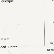
| 9:31 PM MDT | Quarter sized hail reported near Merino, CO, 55.8 miles NW of Yuma, CO, heavy rain plus lots of pea to marble hail accumulation. |
Pennsylvania
| Local Time | Report Details |
|---|---|
| 2:35 AM EDT | Quarter sized hail reported near Erie, PA, 85.1 miles SW of Buffalo, NY |
Nebraska
| Local Time | Report Details |
|---|---|
| 4:55 AM CDT | Golf Ball sized hail reported near Kilgore, NE, 18.4 miles WNW of Valentine, NE |
Connect with Interactive Hail Maps