

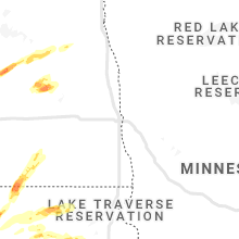
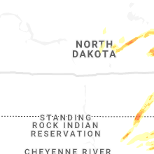
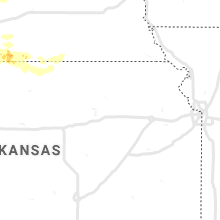
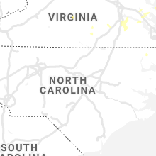
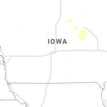
Hail Map for Sunday, August 22, 2021

Number of Impacted Households on 8/22/2021
0
Impacted by 1" or Larger Hail
0
Impacted by 1.75" or Larger Hail
0
Impacted by 2.5" or Larger Hail
Square Miles of Populated Area Impacted on 8/22/2021
0
Impacted by 1" or Larger Hail
0
Impacted by 1.75" or Larger Hail
0
Impacted by 2.5" or Larger Hail


Cities Most Affected by Hail Storms of 8/22/2021
| Hail Size | Demographics of Zip Codes Affected | ||||||
|---|---|---|---|---|---|---|---|
| City | Count | Average | Largest | Pop Density | House Value | Income | Age |
| Mankato, MN | 3 | 1.83 | 2.00 | 379 | $103k | $36.8k | 27.0 |
| Mellette, SD | 2 | 2.38 | 2.75 | 2 | $36k | $37.0k | 47.0 |
| Harvey, ND | 1 | 1.75 | 1.75 | 6 | $49k | $33.4k | 50.7 |
| Amherst, NE | 1 | 1.75 | 1.75 | 4 | $84k | $40.8k | 40.7 |
| Carrington, ND | 1 | 1.75 | 1.75 | 7 | $60k | $32.5k | 45.7 |
| Plankinton, SD | 1 | 1.75 | 1.75 | 3 | $42k | $31.9k | 36.9 |
Hail and Wind Damage Spotted on 8/22/2021
Filter by Report Type:Hail ReportsWind Reports
States Impacted
Rhode Island, Virginia, Massachusetts, Florida, Minnesota, North Dakota, Nebraska, South Dakota, Oklahoma, New MexicoRhode Island
| Local Time | Report Details |
|---|---|
| 8:31 AM EDT | Storm damage reported in washington county RI, 44.7 miles SSW of Providence, RI |
Virginia
| Local Time | Report Details |
|---|---|
| 3:00 PM EDT | Trees down on browns store road. time estimate in northumberland county VA, 72 miles ENE of Richmond, VA |
| 3:06 PM EDT | Half Dollar sized hail reported near Gloucester, VA, 51.3 miles NW of Virginia Beach, VA, report from hickory fork rd and clay bank rd of quarter to half dollar size hail. |
| 4:40 PM EDT | Tree down. time estimated from rada in city of chesapeake county VA, 8.9 miles SW of Virginia Beach, VA |
| 4:43 PM EDT | Numerous trees down near us 460 east of prince george driv in prince george county VA, 32.2 miles SE of Richmond, VA |
| 4:45 PM EDT | Wires down near the intersection of old colchester rd. and stewart r in fairfax county VA, 51.7 miles SW of Baltimore, MD |
| 4:55 PM EDT | Numerous power outages (over 300) likely due to storm just to the north of the petersburg airpor in dinwiddie county VA, 22.5 miles SSE of Richmond, VA |
| 4:55 PM EDT | Tree down on the pohick bay golf cours in fairfax county VA, 52.8 miles SW of Baltimore, MD |
| 5:05 PM EDT | 3-4 inch diameter tree branches dow in fairfax county VA, 53.6 miles SW of Baltimore, MD |
| 5:12 PM EDT | Seven trees down in mason neck state par in fairfax county VA, 53.8 miles SW of Baltimore, MD |
| 5:45 PM EDT | Several trees down. time estimate in sussex county VA, 51.6 miles SE of Richmond, VA |
| 9:19 PM EDT | One tree reported down along county road 727 near appomattox high schoo in appomattox county VA, 61.4 miles E of Roanoke, VA |
| 9:28 PM EDT | Tree reported down at the intersection of double bridges road and salem roa in appomattox county VA, 59 miles E of Roanoke, VA |
| 9:28 PM EDT | A tree down on a powerline along the 4300 block of promise land roa in appomattox county VA, 60.1 miles E of Roanoke, VA |
Massachusetts
| Local Time | Report Details |
|---|---|
| 3:52 PM EDT | Tree and utility pole down on west road in hampden county MA, 72.8 miles WNW of Providence, RI |
Florida
| Local Time | Report Details |
|---|---|
| 4:34 PM EDT | Asos station kjax jacksonville intl airpor in duval county FL, 11.7 miles N of Jacksonville, FL |
| 4:53 PM EDT | Mesonet station xhup huguenot par in amz452 county FL, 15.9 miles ENE of Jacksonville, FL |
Minnesota
| Local Time | Report Details |
|---|---|
| 4:15 PM CDT | Quarter sized hail reported near Luverne, MN, 28.7 miles E of Sioux Falls, SD |
| 7:55 PM CDT | Half Dollar sized hail reported near Mankato, MN, 66.6 miles SSW of Minneapolis, MN, half dollar size hail reported in mankato. picture report relayed via social media. |
| 7:58 PM CDT | Ping Pong Ball sized hail reported near Mankato, MN, 67.7 miles SSW of Minneapolis, MN, ping pong ball size hail reported in mankato. picture report relayed via social media. |
| 7:58 PM CDT | Golf Ball sized hail reported near Mankato, MN, 67.7 miles SSW of Minneapolis, MN, roughly golf ball sized hail in western portion of mankato. picture report received via soclail media. |
| 8:00 PM CDT | Half Dollar sized hail reported near Mankato, MN, 66.4 miles SSW of Minneapolis, MN, half dollar size hail reported near erlandson park. picture report relayed via social media. |
| 8:00 PM CDT | Hen Egg sized hail reported near Mankato, MN, 66.9 miles SSW of Minneapolis, MN, oblong-shaped hailstone approximately 2 inches across reported along parkway ave. picture report relayed via social media. |
| 8:01 PM CDT | Quarter sized hail reported near Mankato, MN, 67.5 miles SSW of Minneapolis, MN, quarter size hail reported from mankato police dept. |
| 8:07 PM CDT | Golf Ball sized hail reported near Mankato, MN, 67.5 miles SSW of Minneapolis, MN, roughly golf ball sized hail near highland park. picture report received via social media. |
North Dakota
| Local Time | Report Details |
|---|---|
| 4:17 PM CDT | Golf Ball sized hail reported near Harvey, ND, 55.1 miles WSW of Devils Lake, ND, photo of large hail taken by the public was submitted by khnd radio. hail had quite a few spikes on it. one inch of rain fell with the hail. time estimated by radar. |
| 6:00 PM CDT | Ping Pong Ball sized hail reported near Carrington, ND, 41.5 miles SSW of Devils Lake, ND |
| 6:00 PM CDT | Golf Ball sized hail reported near Carrington, ND, 41.9 miles SSW of Devils Lake, ND |
| 6:45 PM CDT | Quarter sized hail reported near Pekin, ND, 31.5 miles SE of Devils Lake, ND, pea size to quarter size hail. |
Nebraska
| Local Time | Report Details |
|---|---|
| 5:15 PM CDT | Quarter sized hail reported near Danbury, NE, 52.8 miles NE of Colby, KS, caller reported sporadic dime to quarter sized hail. time estimated by radar. |
| 5:21 PM CDT | Ping Pong Ball sized hail reported near Danbury, NE, 55.8 miles NE of Colby, KS, spotter reported mostly pea to quarter sized hail with sporadic ping pong sized hail mixed in. |
| 5:46 PM CDT | Quarter sized hail reported near Stamford, NE, 87.2 miles N of Hays, KS |
| 5:50 PM CDT | Ping Pong Ball sized hail reported near Wilsonville, NE, 68.9 miles NE of Colby, KS |
| 5:57 PM CDT | Measured gusts of 68 and 71 mph reporte in furnas county NE, 76 miles NE of Colby, KS |
| 6:00 PM CDT | Wind gusts estimated to be near 65 mph at hwy 89 and 283 intersectio in furnas county NE, 79.6 miles NE of Colby, KS |
| 6:04 PM CDT | Quarter sized hail reported near Beaver City, NE, 75.9 miles NE of Colby, KS, report of quarter size hail on hwy 283 approximately 3 miles north of the ne/ks state line. |
| 6:38 PM CDT | Tree damage reported on the north side of town. time estimated from rada in harlan county NE, 80.5 miles SW of Grand Island, NE |
| 6:42 PM CDT | Storm damage reported in harlan county NE, 80.6 miles SW of Grand Island, NE |
| 7:55 PM CDT | Golf Ball sized hail reported near Amherst, NE, 47.2 miles W of Grand Island, NE, report relayed via ntv. |
| 8:09 PM CDT | Quarter sized hail reported near Ashton, NE, 32.5 miles NW of Grand Island, NE |
| 8:53 PM CDT | Storm damage reported in harlan county NE, 80.2 miles SW of Grand Island, NE |
| 9:01 PM CDT | Two trees downed in alma. report from harlan county dispatch. time estimated from rada in harlan county NE, 78.6 miles SW of Grand Island, NE |
| 11:30 PM CDT | Davis weatherlink statio in harlan county NE, 62.9 miles SW of Grand Island, NE |
South Dakota
| Local Time | Report Details |
|---|---|
| 5:29 PM CDT | Storm damage reported in edmunds county SD, 13.3 miles W of Aberdeen, SD |
| 5:32 PM CDT | Quarter sized hail reported near Ipswich, SD, 17.2 miles W of Aberdeen, SD |
| 5:38 PM CDT | Quarter sized hail reported near Aberdeen, SD, 8.2 miles NW of Aberdeen, SD |
| 5:44 PM CDT | Storm damage reported in brown county SD, 3.5 miles N of Aberdeen, SD |
| 5:45 PM CDT | Leaning power polls... large branches dow in brown county SD, 8.2 miles NW of Aberdeen, SD |
| 5:57 PM CDT | Large trees down... major crop damag in brown county SD, 14.1 miles NE of Aberdeen, SD |
| 6:00 PM CDT | 6 to 7 inch branches downe in brown county SD, 14.1 miles NE of Aberdeen, SD |
| 6:15 PM CDT | Power lines down near intersection of 8th ave n and n roosevelt road. report relayed via social medi in brown county SD, 2 miles ENE of Aberdeen, SD |
| 6:24 PM CDT | Half Dollar sized hail reported near Warner, SD, 8.9 miles S of Aberdeen, SD |
| 6:35 PM CDT | Golf Ball sized hail reported near Plankinton, SD, 91.7 miles WNW of Sioux Falls, SD |
| 6:35 PM CDT | Aurora em estimated 80 to 90 mph wind gus in aurora county SD, 91.7 miles WNW of Sioux Falls, SD |
| 6:36 PM CDT | Baseball sized hail reported near Mellette, SD, 15.8 miles S of Aberdeen, SD, largest stone found... many smaller stones too time estimated with radar data. |
| 6:40 PM CDT | Hen Egg sized hail reported near Mellette, SD, 15.8 miles S of Aberdeen, SD, many 1-1.5 inch diameter hail with the largest stones 2-2.25 inch diameter. |
| 6:48 PM CDT | Quarter sized hail reported near Mellette, SD, 15.9 miles SSE of Aberdeen, SD |
| 7:48 PM CDT | Quarter sized hail reported near Letcher, SD, 75.9 miles WNW of Sioux Falls, SD |
Oklahoma
| Local Time | Report Details |
|---|---|
| 6:35 PM CDT | Awos station kgzl stigle in haskell county OK, 39 miles W of Fort Smith, AR |
New Mexico
| Local Time | Report Details |
|---|---|
| 7:45 PM MDT | Ksxu awo in guadalupe county NM, 54.4 miles WSW of Tucumcari, NM |
Connect with Interactive Hail Maps