

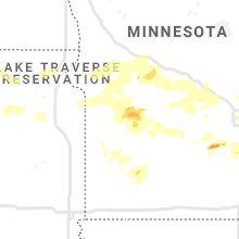
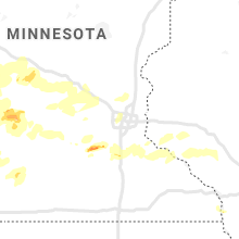
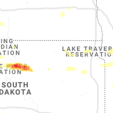
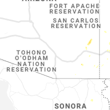
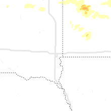
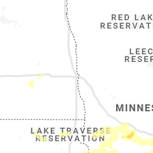
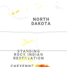
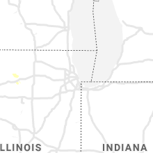
Hail Map for Monday, August 23, 2021

Number of Impacted Households on 8/23/2021
0
Impacted by 1" or Larger Hail
0
Impacted by 1.75" or Larger Hail
0
Impacted by 2.5" or Larger Hail
Square Miles of Populated Area Impacted on 8/23/2021
0
Impacted by 1" or Larger Hail
0
Impacted by 1.75" or Larger Hail
0
Impacted by 2.5" or Larger Hail


Cities Most Affected by Hail Storms of 8/23/2021
| Hail Size | Demographics of Zip Codes Affected | ||||||
|---|---|---|---|---|---|---|---|
| City | Count | Average | Largest | Pop Density | House Value | Income | Age |
Hail and Wind Damage Spotted on 8/23/2021
Filter by Report Type:Hail ReportsWind Reports
Illinois
| Local Time | Report Details |
|---|---|
| 1:30 PM CDT | 20 power poles broken along us-67 south of beardstown. us-67 is currently closed. report relayed by broadcast media. time estimated by rada in cass county IL, 68.7 miles SW of Peoria, IL |
| 2:59 PM CDT | Damage to several large trees. about 100 yards east of intersection of penrose ad weldon roads. time estimated from rada in lee county IL, 82.6 miles S of Madison, WI |
| 3:53 PM CDT | Large tree on a ca in st. clair county IL, 8.7 miles E of Saint Louis, MO |
| 4:15 PM CDT | Small tree limbs down. time estimated from rada in st. clair county IL, 12.7 miles ESE of Saint Louis, MO |
Missouri
| Local Time | Report Details |
|---|---|
| 2:31 PM CDT | Large tree limb down on power lines. street sign blown ove in montgomery county MO, 42.5 miles ENE of Columbia, MO |
| 3:03 PM CDT | Trees snapped off along highway 94. time estimated from rada in st. charles county MO, 41.3 miles W of Saint Louis, MO |
| 3:46 PM CDT | Several large limbs down in the normandy are in st. louis county MO, 8.4 miles NW of Saint Louis, MO |
| 3:47 PM CDT | Multiple trees down in the cool valley area... including one uprooted and some fence damag in st. louis county MO, 8.4 miles NW of Saint Louis, MO |
| 4:43 PM CDT | Measured gust of 61 mp in st. charles county MO, 24.6 miles NNW of Saint Louis, MO |
| 5:09 PM CDT | Small tree limbs down. time estimated from rada in ste. genevieve county MO, 45.4 miles S of Saint Louis, MO |
| 5:26 PM CDT | Trees down in st. mary. time estimated from rada in ste. genevieve county MO, 45.6 miles NNW of Cape Girardeau, MO |
South Dakota
| Local Time | Report Details |
|---|---|
| 5:25 PM CDT | Quarter sized hail reported near White River, SD, 53.1 miles NNW of Valentine, NE |
| 5:30 PM CDT | Storm damage reported in mellette county SD, 53.1 miles NNW of Valentine, NE |
| 4:43 PM MDT | Storm damage reported in butte county SD, 80.4 miles NNW of Rapid City, SD |
| 4:56 PM MDT | Storm damage reported in butte county SD, 80.4 miles NNW of Rapid City, SD |
| 5:55 PM MDT | Storm damage reported in ziebach county SD, 66.6 miles NW of Pierre, SD |
| 5:55 PM MDT | Storm damage reported in ziebach county SD, 65.2 miles WNW of Pierre, SD |
| 5:55 PM MDT | Quarter sized hail reported near Eagle Butte, SD, 57.9 miles NW of Pierre, SD |
| 6:13 PM MDT | Quarter sized hail reported near Eagle Butte, SD, 67.8 miles NW of Pierre, SD, report from mping: quarter (1.00 in.). |
| 6:19 PM MDT | Half Dollar sized hail reported near Eagle Butte, SD, 67.8 miles NW of Pierre, SD, report from mping: half dollar (1.25 in.). |
| 8:02 PM MDT | No lightning activity... but was associated with high-based convective cloud in fall river county SD, 66.9 miles SW of Rapid City, SD |
| 8:25 PM MDT | Roof blown off bar in corson county SD, 85.1 miles S of Bismarck, ND |
| 8:46 PM MDT | Mesonet station 293 timber lake (sddot in dewey county SD, 81.3 miles NNW of Pierre, SD |
| 8:47 PM MDT | Quarter sized hail reported near Timber Lake, SD, 83.2 miles NNW of Pierre, SD, social media report. |
| 8:52 PM MDT | Storm damage reported in corson county SD, 82.6 miles S of Bismarck, ND |
| 9:08 PM MDT | Mesonet station 178 trail city (sddot in dewey county SD, 79.3 miles NNW of Pierre, SD |
| 10:48 PM CDT | Mesonet station 50 herreid (sddot in campbell county SD, 73 miles SSE of Bismarck, ND |
| 11:43 PM CDT | Mesonet station 184 eureka (sddot in mcpherson county SD, 47.4 miles WNW of Aberdeen, SD |
| 12:27 AM CDT | Storm damage reported in brown county SD, 32.5 miles NNW of Aberdeen, SD |
| 12:28 AM CDT | Mesonet station 215 jct sd47/sd26 (sddot in hyde county SD, 52.7 miles ENE of Pierre, SD |
| 12:28 AM CDT | Quarter sized hail reported near Seneca, SD, 51.5 miles WSW of Aberdeen, SD |
| 12:33 AM CDT | Mesonet station 49 frederick (sddot in brown county SD, 32.6 miles N of Aberdeen, SD |
| 5:37 AM CDT | Mesonet station 45 andover (sddot in day county SD, 28.8 miles E of Aberdeen, SD |
| 6:33 AM CDT | Mesonet station 55 summit (sddot in roberts county SD, 69.7 miles WNW of Montevideo, MN |
Louisiana
| Local Time | Report Details |
|---|---|
| 9:35 PM CDT | Awos station kdlp west delta 27 in gmz552 county LA, 65.6 miles SSE of New Orleans, LA |
North Dakota
| Local Time | Report Details |
|---|---|
| 1:02 AM CDT | Personal weather station in oakes measured 70 mph sustained wind gusting to 97 mp in dickey county ND, 50.8 miles NNE of Aberdeen, SD |
Nebraska
| Local Time | Report Details |
|---|---|
| 2:43 AM CDT | Storm damage reported in cherry county NE, 32 miles S of Valentine, NE |
Minnesota
| Local Time | Report Details |
|---|---|
| 4:00 AM CDT | Quarter sized hail reported near Lonsdale, MN, 35.5 miles SSW of Minneapolis, MN |
| 4:30 AM CDT | Corrects previous tstm wnd gst report from 3 e glenwood. measured at kgh in pope county MN, 52 miles NNE of Montevideo, MN |
| 4:30 AM CDT | 3 roads are blocked by downed trees in glenwoo in pope county MN, 51 miles NNE of Montevideo, MN |
| 5:45 AM CDT | A tree was partially blocking hwy 7 on the west side of hutchinso in mcleod county MN, 55.5 miles W of Minneapolis, MN |
Connect with Interactive Hail Maps