

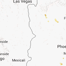
Hail Map for Tuesday, August 27, 2013

Number of Impacted Households on 8/27/2013
0
Impacted by 1" or Larger Hail
0
Impacted by 1.75" or Larger Hail
0
Impacted by 2.5" or Larger Hail
Square Miles of Populated Area Impacted on 8/27/2013
0
Impacted by 1" or Larger Hail
0
Impacted by 1.75" or Larger Hail
0
Impacted by 2.5" or Larger Hail


Cities Most Affected by Hail Storms of 8/27/2013
| Hail Size | Demographics of Zip Codes Affected | ||||||
|---|---|---|---|---|---|---|---|
| City | Count | Average | Largest | Pop Density | House Value | Income | Age |
| Bonduel, WI | 1 | 1.75 | 1.75 | 47 | $89k | $42.0k | 38.5 |
| Dupree, SD | 1 | 1.75 | 1.75 | 0 | $26k | $26.9k | 32.8 |
Hail and Wind Damage Spotted on 8/27/2013
Filter by Report Type:Hail ReportsWind Reports
Michigan
| Local Time | Report Details |
|---|---|
| 8:05 AM EDT | Report relayed by abc 29/8. 8 inch limbs down with a few tree and power lines near 19 mile rd and newcosta rd in newaygo county MI, 53.7 miles N of Grand Rapids, MI |
| 12:50 AM EDT | Multiple trees down in livingston county MI, 33.9 miles SSW of Flint, MI |
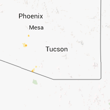
Arizona
| Local Time | Report Details |
|---|---|
| 12:46 PM MST | Quarter sized hail reported near Flagstaff, AZ, 7.1 miles SSW of Flagstaff, AZ |
| 4:30 PM MST | Delayed report...wind gusts to 60mph...blowing dust with visibilities below 1 mil in pinal county AZ, 39.7 miles S of Phoenix, AZ |
| 5:37 PM MST | Wind e60 mph. n warren and w miller rds. pea sized hai in maricopa county AZ, 38.8 miles SSW of Phoenix, AZ |
| 5:44 PM MST | Quarter sized hail reported near Maricopa, AZ, 36 miles S of Phoenix, AZ, dime to quarter sized hailstones. 0.54 inches rain in 15 minutes. part of porch roof blown off by wind and rain. |
North Dakota
| Local Time | Report Details |
|---|---|
| 3:50 PM MDT | No hai in adams county ND, 82.4 miles SW of Bismarck, ND |
Wisconsin
| Local Time | Report Details |
|---|---|
| 4:52 PM CDT | Quarter sized hail reported near Shawano, WI, 34 miles WNW of Green Bay, WI, courtesy of wluk-tv |
| 5:02 PM CDT | Half Dollar sized hail reported near Shawano, WI, 30.1 miles WNW of Green Bay, WI |
| 5:07 PM CDT | Golf Ball sized hail reported near Bonduel, WI, 26 miles NW of Green Bay, WI, via social media |
| 7:45 PM CDT | Trees down in manitowoc county WI, 41.6 miles S of Green Bay, WI |
| 7:50 PM CDT | Tree down on power line near elkart lake causing arcing. time of event estimated by radar. report recived 915 pm cd in sheboygan county WI, 47.1 miles S of Green Bay, WI |
| 7:52 PM CDT | Few trees or large tree branches knocked some power lines down near county line north of elkhart lake. corrected for date and tim in sheboygan county WI, 43.7 miles S of Green Bay, WI |
South Dakota
| Local Time | Report Details |
|---|---|
| 4:43 PM MDT | Storm damage reported in harding county SD, 82.4 miles N of Rapid City, SD |
| 5:50 PM MDT | Storm damage reported in perkins county SD, 93.2 miles NNE of Rapid City, SD |
| 6:00 PM MDT | Public reports wind damage to grain bins and tree in corson county SD, 77.9 miles SSW of Bismarck, ND |
| 6:05 PM MDT | Quarter sized hail reported near Faith, SD, 95 miles NNE of Rapid City, SD |
| 6:15 PM MDT | Small trees blown ove in corson county SD, 73 miles SSW of Bismarck, ND |
| 6:27 PM MDT | Storm damage reported in ziebach county SD, 95.4 miles NW of Pierre, SD |
| 6:27 PM MDT | Quarter sized hail reported near Dupree, SD, 95.4 miles NW of Pierre, SD |
| 6:42 PM MDT | Pole barn lifted off foundation in ziebach county SD, 92.2 miles NW of Pierre, SD |
| 7:20 PM MDT | Golf Ball sized hail reported near Dupree, SD, 79.7 miles NW of Pierre, SD |
| 8:20 PM MDT | Quarter sized hail reported near Meadow, SD, 110.6 miles NNE of Rapid City, SD |
| 8:20 PM MDT | Storm damage reported in perkins county SD, 110.6 miles NNE of Rapid City, SD |
| 11:01 PM CDT | Storm damage reported in potter county SD, 44.4 miles N of Pierre, SD |
| 10:40 PM MDT | Worthless creek out of its banks in ziebach county SD, 92.3 miles NW of Pierre, SD |
| 11:15 PM MDT | 1.50 inches rainfall and pea size hail in ziebach county SD, 100.5 miles NW of Pierre, SD |
| 11:15 PM MDT | Quarter sized hail reported near Timber Lake, SD, 83.4 miles NNW of Pierre, SD |
| 11:50 PM MDT | Small hail with 50-60 mph winds in dewey county SD, 73.9 miles NNW of Pierre, SD |
| 12:50 AM MDT | 24hr rainfall 2.00 inches in ziebach county SD, 94.3 miles NW of Pierre, SD |
| 4:00 AM CDT | Peak wind gust measured from the forest city rwi in potter county SD, 44.4 miles N of Pierre, SD |
| 4:02 AM CDT | Forest city bridge rwis in potter county SD, 44.4 miles N of Pierre, SD |
| 4:15 AM CDT | K0d8 gettysburg superawos in potter county SD, 47.2 miles NNE of Pierre, SD |
| 5:20 AM CDT | Large cottonwoods snapped in two estimate 60-70 mph winds in hand county SD, 54.2 miles SW of Aberdeen, SD |
| 5:40 AM CDT | Peak wind gust measured from the miranda rwi in faulk county SD, 40.9 miles SW of Aberdeen, SD |
| 6:05 AM CDT | Numerous 2 ft trees snapped at base... garage destroyed and laid across field... and campers tipped on east side of cottonwood lake in spink county SD, 47 miles S of Aberdeen, SD |
| 6:20 AM CDT | Home wind system in spink county SD, 49.7 miles S of Aberdeen, SD |
| 6:23 AM CDT | Several trees down and windows blown out of homes in tular in spink county SD, 49.7 miles S of Aberdeen, SD |
| 6:25 AM CDT | Roof damage to local school in spink county SD, 49.7 miles S of Aberdeen, SD |
| 6:45 AM CDT | Trees and tree branches down estimated wind 60-70 mph power in and out in spink county SD, 47.2 miles S of Aberdeen, SD |
| 6:45 AM CDT | Trees and tree branches down estimated wind 60-70 mph power in and out in spink county SD, 47.5 miles S of Aberdeen, SD |
Connect with Interactive Hail Maps