

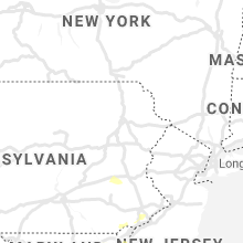
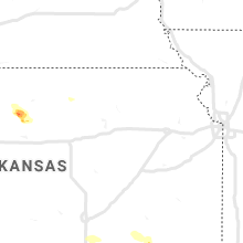
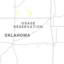
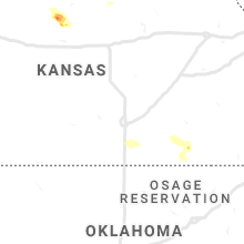
Hail Map for Friday, August 28, 2020

Number of Impacted Households on 8/28/2020
0
Impacted by 1" or Larger Hail
0
Impacted by 1.75" or Larger Hail
0
Impacted by 2.5" or Larger Hail
Square Miles of Populated Area Impacted on 8/28/2020
0
Impacted by 1" or Larger Hail
0
Impacted by 1.75" or Larger Hail
0
Impacted by 2.5" or Larger Hail


Cities Most Affected by Hail Storms of 8/28/2020
| Hail Size | Demographics of Zip Codes Affected | ||||||
|---|---|---|---|---|---|---|---|
| City | Count | Average | Largest | Pop Density | House Value | Income | Age |
| Flushing, MI | 2 | 1.88 | 2.00 | 478 | $128k | $55.9k | 44.0 |
| Fort Washington, MD | 1 | 1.75 | 1.75 | 2033 | $163k | $74.9k | 41.5 |
| Ashley, MI | 1 | 1.75 | 1.75 | 22 | $74k | $37.6k | 42.6 |
Hail and Wind Damage Spotted on 8/28/2020
Filter by Report Type:Hail ReportsWind Reports
States Impacted
Pennsylvania, Ohio, Wisconsin, Tennessee, Maryland, Kentucky, Michigan, West Virginia, Delaware, Mississippi, Alabama, Iowa, New Jersey, New Mexico, Virginia, North Carolina, Kansas, Texas, Indiana, NevadaPennsylvania
| Local Time | Report Details |
|---|---|
| 9:00 AM EDT | Reports of multiple trees down near the mercer and crawford county borde in mercer county PA, 68.6 miles E of Cleveland, OH |
| 9:00 AM EDT | Trees reported down around the tow in mercer county PA, 68.3 miles E of Cleveland, OH |
| 9:07 AM EDT | Trees reported down in the vicinity of 44 band hill r in mercer county PA, 62.4 miles NNW of Pittsburgh, PA |
| 9:44 AM EDT | Trees reported down along rte 308 near tow in venango county PA, 52.9 miles N of Pittsburgh, PA |
| 10:10 AM EDT | Trees and power lines down along rte 338 in kno in clarion county PA, 59.7 miles NNE of Pittsburgh, PA |
| 10:56 AM EDT | Trees reported down in the vicinity of 44 band hill r in mercer county PA, 62.4 miles NNW of Pittsburgh, PA |
| 10:57 AM EDT | Trees reported down around the tow in mercer county PA, 68.3 miles E of Cleveland, OH |
| 11:01 AM EDT | Trees and power lines down along rte 338 in kno in clarion county PA, 59.7 miles NNE of Pittsburgh, PA |
| 1:30 PM EDT | 6 to 8 trees down reported at greenwod furnac in huntingdon county PA, 11.5 miles SSE of State College, PA |
| 1:33 PM EDT | Trees down on wire in huntingdon county PA, 26.3 miles SSW of State College, PA |
| 1:50 PM EDT | Snapped power poles on route 2 in huntingdon county PA, 6.8 miles SSW of State College, PA |
| 2:00 PM EDT | 12+ trees down and some structural damage on propert in huntingdon county PA, 35.7 miles S of State College, PA |
| 2:08 PM EDT | Tree limbs on wires along mountain roa in northumberland county PA, 62.1 miles SW of Scranton, PA |
| 2:15 PM EDT | Trees down on wire in northumberland county PA, 60.5 miles SW of Scranton, PA |
| 2:38 PM EDT | Trees down on wire in cumberland county PA, 55.7 miles SSE of State College, PA |
| 2:46 PM EDT | Trees down on wire in franklin county PA, 61.5 miles SSE of State College, PA |
| 2:50 PM EDT | Trees down on wire in franklin county PA, 65.5 miles S of State College, PA |
| 2:58 PM EDT | Trees down on wire in lebanon county PA, 76 miles NNE of Baltimore, MD |
| 2:59 PM EDT | Trees down on wire in lebanon county PA, 74.9 miles NNE of Baltimore, MD |
| 3:00 PM EDT | Downed trees and wires near mountain road in albany twp. time estimated from rada in berks county PA, 54.2 miles SSW of Scranton, PA |
| 3:04 PM EDT | Trees down on wire in lebanon county PA, 77 miles N of Baltimore, MD |
| 3:06 PM EDT | Trees down on wires on golf course roa in york county PA, 60.2 miles NNW of Baltimore, MD |
| 3:09 PM EDT | Downed trees and wires near blue rocks road in lenhartsville. time estimated from rada in berks county PA, 58.1 miles SSW of Scranton, PA |
| 3:11 PM EDT | Downed tree and wires on old route 22 west of lenhartsville. time estimated from rada in berks county PA, 58.6 miles SSW of Scranton, PA |
| 3:12 PM EDT | Trees down on wire in adams county PA, 46.4 miles NNW of Baltimore, MD |
| 3:25 PM EDT | Multiple downed power poles on kutztown road. time estimated from rada in berks county PA, 63.2 miles S of Scranton, PA |
| 3:25 PM EDT | Storm damage reported in berks county PA, 72.9 miles SSW of Scranton, PA |
| 3:26 PM EDT | Trees brought down power lines. time estimated from rada in berks county PA, 74.5 miles SSW of Scranton, PA |
| 3:27 PM EDT | Downed tree and wires near the intersection of commons road and baldy road. time estimated from rada in berks county PA, 62.4 miles S of Scranton, PA |
| 3:27 PM EDT | Downed tree near the intersection of hilltop road and upper van reed road. time estimated from rada in berks county PA, 73.9 miles SSW of Scranton, PA |
| 3:28 PM EDT | Trees brought down power lines. time estimated from rada in berks county PA, 75.3 miles SSW of Scranton, PA |
| 3:29 PM EDT | Downed trees and wires near walnut lane. time estimated from rada in lehigh county PA, 60.2 miles S of Scranton, PA |
| 3:30 PM EDT | Tree limbs and utility wires dow in berks county PA, 64.9 miles S of Scranton, PA |
| 3:30 PM EDT | Some small branches down in the area west of reading. time estimated from rada in berks county PA, 75.6 miles SSW of Scranton, PA |
| 3:36 PM EDT | Downed tree near the intersection of woodland avenue and carsonia avenue in lower alsace twp. time estimated from rada in berks county PA, 74 miles S of Scranton, PA |
| 3:36 PM EDT | Downed tree and wires on friedensburg road in alsace twp. time estimated from rada in berks county PA, 72.3 miles S of Scranton, PA |
| 3:39 PM EDT | Downed power lines in the vicinity of ruppert school road in pike twp. time estimated from rada in berks county PA, 67.7 miles S of Scranton, PA |
| 3:39 PM EDT | Downed power lines in the vicinity of old gibraltar road. time estimated from rada in berks county PA, 78.7 miles S of Scranton, PA |
| 3:45 PM EDT | Tree limbs down in tylerspor in montgomery county PA, 74.6 miles SSE of Scranton, PA |
| 3:45 PM EDT | Downed tree and wires near the intersection of manatawny road and diener drive. time estimated from rada in berks county PA, 74.6 miles S of Scranton, PA |
| 3:45 PM EDT | Downed power lines in the vicinity of pond road in earl twp. time estimated from rada in berks county PA, 72.5 miles S of Scranton, PA |
| 3:48 PM EDT | Downed power lines in the vicinity of main street east of monocacy. time estimated from rada in berks county PA, 79.5 miles S of Scranton, PA |
| 3:48 PM EDT | Downed tree blocking deep creek road near hill road. time estimated from rada in montgomery county PA, 72.7 miles S of Scranton, PA |
| 3:50 PM EDT | Downed trees and wires on gerryville pike near brinckman road. time estimated from rada in montgomery county PA, 71.9 miles S of Scranton, PA |
| 3:55 PM EDT | Several reports of downed trees and wires south of trumbauersville. time estimated from rada in bucks county PA, 71.7 miles S of Scranton, PA |
| 3:55 PM EDT | Storm damage reported in chester county PA, 57.4 miles NE of Baltimore, MD |
| 4:05 PM EDT | Numerous reports of trees and wires down between telford and chalfont... with widespread power outages. time estimated from rada in bucks county PA, 71.6 miles WSW of Brooklyn, NY |
| 4:08 PM EDT | Downed tree on towamencin avenue near second street. time estimated from rada in montgomery county PA, 75 miles WSW of Brooklyn, NY |
| 4:11 PM EDT | Downed tree blocking manor road near red oak drive. time estimated from rada in chester county PA, 66.5 miles NE of Baltimore, MD |
| 4:12 PM EDT | Tree in wires. time estimated from rada in bucks county PA, 72.1 miles WSW of Brooklyn, NY |
| 4:13 PM EDT | Downed tree on hadfield road. time estimated from rada in chester county PA, 67 miles NE of Baltimore, MD |
| 4:14 PM EDT | Widespread tree damage. time estimated from rada in bucks county PA, 69.4 miles WSW of Brooklyn, NY |
| 4:14 PM EDT | Trees down. start of a path or zone of tree damag in bucks county PA, 72.4 miles WSW of Brooklyn, NY |
| 4:15 PM EDT | Several trees dow in bucks county PA, 68.7 miles WSW of Brooklyn, NY |
| 4:18 PM EDT | Downed tree blocking westbound route 30 bypass near bailey road. time estimated from rada in chester county PA, 67.2 miles NE of Baltimore, MD |
| 4:20 PM EDT | Tree and utility wires down on farnum roa in delaware county PA, 78.7 miles NE of Baltimore, MD |
| 4:21 PM EDT | Trees down. time estimated from rada in bucks county PA, 62.8 miles WSW of Brooklyn, NY |
| 4:21 PM EDT | Downed tree blocking king road near ravine road. time estimated from rada in chester county PA, 74.5 miles NE of Baltimore, MD |
| 4:21 PM EDT | Downed tree blocking moreland avenue near maple avenue. time estimated from rada in montgomery county PA, 69.4 miles WSW of Brooklyn, NY |
| 4:21 PM EDT | Downed tree on lancaster avenue near lockwood lane. time estimated from rada in chester county PA, 74.9 miles NE of Baltimore, MD |
| 4:23 PM EDT | Downed tree on jenkintown road near north hills avenue. time estimated from rada in montgomery county PA, 73.3 miles WSW of Brooklyn, NY |
| 4:23 PM EDT | Downed tree on forest lane near chester road. time estimated from rada in chester county PA, 75.7 miles NE of Baltimore, MD |
| 4:23 PM EDT | Photos of downed tree in bucks county PA, 64.9 miles WSW of Brooklyn, NY |
| 4:26 PM EDT | Downed tree on cornwallis drive. time estimated from rada in chester county PA, 74.4 miles NE of Baltimore, MD |
| 4:26 PM EDT | Downed tree blocking wollerton alley near darlington street. time estimated from rada in chester county PA, 70.5 miles NE of Baltimore, MD |
| 4:26 PM EDT | Downed trees on deer run road and valley road in abington. time estimated from rada in montgomery county PA, 69.5 miles WSW of Brooklyn, NY |
| 4:26 PM EDT | Downed tree limbs blocking militia hill road near joshua road. time estimated from rada in montgomery county PA, 76.4 miles WSW of Brooklyn, NY |
| 4:29 PM EDT | Several reports of downed trees and power lines in the richboro area. time estimated from rada in bucks county PA, 63.7 miles WSW of Brooklyn, NY |
| 4:32 PM EDT | Trees down in the area. time estimated from rada in bucks county PA, 58.9 miles WSW of Brooklyn, NY |
| 4:32 PM EDT | Tree limbs and branches downe in bucks county PA, 65.9 miles WSW of Brooklyn, NY |
| 4:36 PM EDT | Downed tree on city avenue near berwick road in lower merion twp. time estimated from rada in montgomery county PA, 81.9 miles SW of Brooklyn, NY |
| 4:43 PM EDT | Several reports of downed trees and power lines in the levittown and tullytown area. time estimated from rada in bucks county PA, 56.3 miles SW of Brooklyn, NY |
| 4:59 PM EDT | Multiple trees down. time estimated from rada in bucks county PA, 70 miles WSW of Brooklyn, NY |
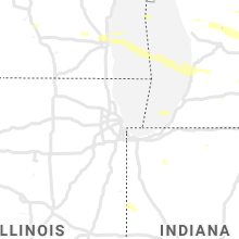
Ohio
| Local Time | Report Details |
|---|---|
| 11:44 AM EDT | Quarter sized hail reported near Uniontown, OH, 39.1 miles SSE of Cleveland, OH |
| 12:53 PM EDT | Large tree limbs down in franklin county OH, 9.2 miles NE of Columbus, OH |
| 12:58 PM EDT | A large section of a 50 foot tree dow in franklin county OH, 11.6 miles NNE of Columbus, OH |
| 12:59 PM EDT | Several trees down near the intersection of walnut street and orchard lane. time estimated from rada in franklin county OH, 11.8 miles NNE of Columbus, OH |
| 1:11 PM EDT | A tree was downed. time estimated from rada in logan county OH, 41.5 miles NW of Columbus, OH |
| 1:12 PM EDT | A power pole was blown down. time estimated from rada in logan county OH, 49.2 miles NW of Columbus, OH |
| 1:15 PM EDT | Several trees reported down throughout the county between 1 and 130 p in delaware county OH, 23.6 miles N of Columbus, OH |
| 1:15 PM EDT | Trees down in delaware county OH, 24 miles NNW of Columbus, OH |
| 1:25 PM EDT | A few trees and power lines down in the heath and newark areas. time estimated by rada in licking county OH, 30.2 miles E of Columbus, OH |
| 1:46 PM EDT | Storm damage reported in morrow county OH, 37.6 miles N of Columbus, OH |
| 2:18 PM EDT | 2 trees dow in richland county OH, 58.8 miles NNE of Columbus, OH |
| 3:14 PM EDT | One tree down on a house in logan county OH, 44.8 miles WNW of Columbus, OH |
| 5:13 PM EDT | Pole down onto a house in clermont county OH, 21.8 miles SE of Cincinnati, OH |
| 5:30 PM EDT | One tree down in brown county OH, 29 miles ESE of Cincinnati, OH |
| 5:39 PM EDT | Several healthy tree limbs down. time est from rada in brown county OH, 28.4 miles E of Cincinnati, OH |
| 7:03 PM EDT | Trees reported down near the intersection of liberty hill rd and oh-77 in ross county OH, 45.7 miles S of Columbus, OH |
| 7:03 PM EDT | Trees reported down near the intersection of liberty hill rd and oh-77 in ross county OH, 45.7 miles S of Columbus, OH |
| 7:06 PM EDT | Trees reported down near the intersection of three locks rd and u.s. 23. time estimated from rada in ross county OH, 46.5 miles S of Columbus, OH |
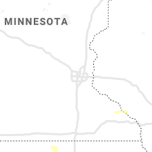
Wisconsin
| Local Time | Report Details |
|---|---|
| 11:31 AM CDT | Large tree branches down. time estimated from rada in washington county WI, 54.1 miles ENE of Madison, WI |
Tennessee
| Local Time | Report Details |
|---|---|
| 12:05 PM CDT | Pictures of trees down... reported in east hickman count in hickman county TN, 45.8 miles SW of Nashville, TN |
| 12:11 PM CDT | Trees down and a few power outages in the primm springs area in hickman county TN, 35.7 miles SW of Nashville, TN |
| 12:12 PM CDT | Picture of tree down. time estimated via rada in hickman county TN, 33.1 miles SW of Nashville, TN |
| 12:19 PM CDT | Trees down on old franklin road in williamson county TN, 27.1 miles WSW of Nashville, TN |
| 12:30 PM CDT | Report of trees down on powerlines. time estimated via rada in cheatham county TN, 18.6 miles WSW of Nashville, TN |
| 12:42 PM CDT | Report of trees down on powerlines. time estimated via rada in cheatham county TN, 17.5 miles WNW of Nashville, TN |
| 1:10 PM CDT | Trees down in davidson county TN, 7 miles N of Nashville, TN |
| 1:14 PM CDT | Two power poles and one large tree damaged in davidson county TN, 12.6 miles N of Nashville, TN |
| 5:27 PM CDT | Report of barn destroyed on cecil laxson r in warren county TN, 48.2 miles NW of Chattanooga, TN |
| 6:10 PM CDT | Large tree down blocking road at 1621 copenhaver road. time estimate in warren county TN, 51.8 miles NNW of Chattanooga, TN |
| 6:54 PM CDT | Large tree limbs down on old railroad grade road in white county TN, 61.6 miles N of Chattanooga, TN |
| 7:25 PM CDT | Roof damage to a home at 6207 cheyenne trail in putnam county TN, 64 miles E of Nashville, TN |
Maryland
| Local Time | Report Details |
|---|---|
| 1:57 PM EDT | A pole and wires were down near the intersection of md-155 level road and graceview driv in harford county MD, 32.6 miles NE of Baltimore, MD |
| 2:30 PM EDT | Trained spotter reports winds in excess of 60 mph at hacks point on route 213. time estimated from rada in cecil county MD, 41.3 miles ENE of Baltimore, MD |
| 2:43 PM EDT | Several reports of downed trees and wires in the cecilton area. time estimated from rada in cecil county MD, 40.3 miles E of Baltimore, MD |
| 2:45 PM EDT | Several reports of downed trees and wires in the warwick area. time estimated from rada in cecil county MD, 45.3 miles ENE of Baltimore, MD |
| 3:42 PM EDT | Tree down near the intersection of klees mill rd and terrapin d in carroll county MD, 22.5 miles WNW of Baltimore, MD |
| 3:47 PM EDT | Tree down on klees mill r in carroll county MD, 22.5 miles WNW of Baltimore, MD |
| 4:13 PM EDT | Tree down on md-136 at trappe church roa in harford county MD, 29.4 miles NE of Baltimore, MD |
| 4:18 PM EDT | Tree down at the intersection of md-623 north/south at glen cove r in harford county MD, 34.3 miles NE of Baltimore, MD |
| 4:20 PM EDT | Several downed trees and power line in cecil county MD, 41.1 miles NE of Baltimore, MD |
| 4:40 PM EDT | Trees and wires dow in cecil county MD, 49.2 miles ENE of Baltimore, MD |
| 4:40 PM EDT | Tree down on md-22 west at us-4 in harford county MD, 28.8 miles ENE of Baltimore, MD |
| 4:42 PM EDT | Downed powerlines near 15 fulks corner in gaithersbur in montgomery county MD, 33.3 miles WSW of Baltimore, MD |
| 4:46 PM EDT | Large branch snapped and downed power lines and power pol in montgomery county MD, 22.2 miles WSW of Baltimore, MD |
| 5:10 PM EDT | Outflow winds downed trees and destroyed a transformer. time estimated from rada in kent county MD, 29.5 miles E of Baltimore, MD |
| 6:29 PM EDT | Golf Ball sized hail reported near Fort Washington, MD, 38.2 miles SSW of Baltimore, MD |
| 1:50 AM EDT | Trees downed on public landing road. time is radar estimate in worcester county MD, 17.6 miles SW of Ocean City, MD |
Kentucky
| Local Time | Report Details |
|---|---|
| 1:03 PM CDT | Dispatch reported trees and power lines down within city limits of russellville. time estimated from rada in logan county KY, 47.6 miles N of Nashville, TN |
Michigan
| Local Time | Report Details |
|---|---|
| 2:05 PM EDT | Corrects previous non-tstm wnd gst report from 3 ene sandstone. asos station kjxn jackson county-reynolds field airpor in jackson county MI, 64.9 miles SW of Flint, MI |
| 2:10 PM EDT | Several trees and wires down within city limits. time is estimate in jackson county MI, 64.8 miles SW of Flint, MI |
| 3:20 PM EDT | Report of large 10 inch branch down partially covering westbound willis rd near whittaker r in washtenaw county MI, 58.9 miles S of Flint, MI |
| 4:30 PM EDT | Golf Ball sized hail reported near Ashley, MI, 42 miles WNW of Flint, MI, ashley fire department reported hail the size of golf balls to central dispatch. time estimated from radar. |
| 5:02 PM EDT | Media passed along a photo of snapped tree in genesee county MI, 10.1 miles NW of Flint, MI |
| 5:05 PM EDT | Half Dollar sized hail reported near Flushing, MI, 7.5 miles WNW of Flint, MI |
| 5:07 PM EDT | Golf Ball sized hail reported near Flushing, MI, 7.1 miles WNW of Flint, MI |
| 5:08 PM EDT | Quarter sized hail reported near Flint, MI, 4.7 miles NW of Flint, MI |
| 5:10 PM EDT | Hen Egg sized hail reported near Flushing, MI, 7.1 miles WNW of Flint, MI |
| 9:49 PM EDT | Multiple trees and wires down. reported by multiple member of the publi in kent county MI, 18.5 miles NNE of Grand Rapids, MI |
| 10:30 PM EDT | Multiple trees down on the south side of long lak in ionia county MI, 29.6 miles ENE of Grand Rapids, MI |
| 11:35 PM EDT | Trees dow in shiawassee county MI, 34.8 miles WSW of Flint, MI |
West Virginia
| Local Time | Report Details |
|---|---|
| 2:56 PM EDT | Numerous trees reported dow in ohio county WV, 44.2 miles SW of Pittsburgh, PA |
| 3:04 PM EDT | Numerous trees reported dow in ohio county WV, 44.5 miles SW of Pittsburgh, PA |
| 3:04 PM EDT | Half Dollar sized hail reported near Morgantown, WV, 51.5 miles N of Elkins, WV |
Delaware
| Local Time | Report Details |
|---|---|
| 3:25 PM EDT | Downed tree limbs and power lines reported in the woodland beach area. time estimated from rada in kent county DE, 60.6 miles E of Baltimore, MD |
| 5:35 PM EDT | Several reports of trees and wires down in the vicinity of cheswold. time estimated from radar and power outage report in kent county DE, 54.9 miles E of Baltimore, MD |
| 6:52 PM EDT | Downed tree limbs and wires near staytonville road east of farmington. time estimated from rada in sussex county DE, 42.6 miles NNW of Ocean City, MD |
Mississippi
| Local Time | Report Details |
|---|---|
| 2:45 PM CDT | Damage to a store front and radio tower. large tree down on hom in alcorn county MS, 48.9 miles WNW of Florence, AL |
| 3:15 PM CDT | Large tree split in houlk in chickasaw county MS, 40.7 miles NNW of Starkville, MS |
Alabama
| Local Time | Report Details |
|---|---|
| 3:32 PM CDT | Corrects previous tstm wnd dmg report from sheffield. trees reported down on w. montgomery ave in sheffield. time estimated by rada in colbert county AL, 3.1 miles SSW of Florence, AL |
| 3:35 PM CDT | Trees reported down on power pole in lauderdale county AL, 1.4 miles NNE of Florence, AL |
| 3:55 PM CDT | Trees reported down on w. montgomery ave in sheffiel in colbert county AL, 3.1 miles SSW of Florence, AL |
| 3:57 PM CDT | Trees down across the road on cr 168 at this locatio in lauderdale county AL, 15.6 miles NE of Florence, AL |
| 4:00 PM CDT | A few trees blown down in the hamilton are in marion county AL, 48.9 miles SSW of Florence, AL |
| 4:11 PM CDT | Trees reported down at 4552 cr 7 in lauderdale county AL, 24.8 miles E of Florence, AL |
| 4:11 PM CDT | Several trees down along cranal road at the sipsey river bridg in winston county AL, 38.5 miles SSE of Florence, AL |
| 4:16 PM CDT | Corrects previous tstm wnd dmg report from 1 se moreland. at least 3 structures were damaged in the moreland community south of grayson. several trees were also blown d in winston county AL, 44.2 miles SSE of Florence, AL |
| 4:26 PM CDT | A tree was reported down at 302 county line road onto a power lin in lauderdale county AL, 12.1 miles NNE of Florence, AL |
| 4:38 PM CDT | Multiple trees were blown down along highway 2 east of highway 33. possible tornad in winston county AL, 45.8 miles SSE of Florence, AL |
| 4:39 PM CDT | Lawrence co. ema reports trees down in the speake community near cr20 in lawrence county AL, 43.4 miles SE of Florence, AL |
| 4:42 PM CDT | A few trees were blown down in the sulligent are in lamar county AL, 49.4 miles NE of Starkville, MS |
| 4:50 PM CDT | A few structures were damaged in the moreland community south of grayso in winston county AL, 44.2 miles SSE of Florence, AL |
| 4:54 PM CDT | Building material scattered all over the place at wilkins builder in winston county AL, 46 miles SSE of Florence, AL |
| 5:16 PM CDT | Trees were blown down. possible tornad in winston county AL, 46.7 miles SE of Florence, AL |
| 5:22 PM CDT | Sardis fire reports damage to a barn and trees down on cr 1069 in cullman co. possible tornad in cullman county AL, 48.9 miles SE of Florence, AL |
| 5:25 PM CDT | Mobile home damage on cr 1059 and trees down as wel in cullman county AL, 50.3 miles SE of Florence, AL |
| 5:40 PM CDT | Trees down north of the airport in vinemon in cullman county AL, 53.8 miles N of Birmingham, AL |
| 8:56 PM CDT | Red bay pd reports trees and power lines down on newell road. several power outages in the area of red ba in franklin county AL, 35.5 miles SW of Florence, AL |
Iowa
| Local Time | Report Details |
|---|---|
| 3:39 PM CDT | Quarter sized hail reported near Gladbrook, IA, 55.1 miles WNW of Cedar Rapids, IA, trained spotter reported quarter sized hail near gladbrook... ia. |
| 3:50 PM CDT | Quarter sized hail reported near Traer, IA, 43.5 miles WNW of Cedar Rapids, IA, mostly dime sized but a few stones to quarter sized. winds to 40 mph. |
| 4:03 PM CDT | Half Dollar sized hail reported near Dysart, IA, 35.3 miles WNW of Cedar Rapids, IA, relayed by woi-tv. time estimated from radar. |
| 4:10 PM CDT | Storm damage reported in benton county IA, 36.6 miles WNW of Cedar Rapids, IA |
| 4:10 PM CDT | Storm damage reported in benton county IA, 36.6 miles WNW of Cedar Rapids, IA |
| 4:10 PM CDT | Quarter sized hail reported near Dysart, IA, 36.6 miles WNW of Cedar Rapids, IA, dime to quarter size. |
| 4:29 PM CDT | Large tree down. many large limbs also dow in delaware county IA, 32.8 miles NE of Cedar Rapids, IA |
| 4:30 PM CDT | Large limb down. at least 12 inches in diamete in delaware county IA, 34.1 miles NE of Cedar Rapids, IA |
| 4:30 PM CDT | Social media report of large tree limbs down (estimated 8 inches from photo) on power lines. power lines were also down in other places in tow in delaware county IA, 33.7 miles NE of Cedar Rapids, IA |
| 4:31 PM CDT | Large tree limb down... at least a foot in diameter. reported on social medi in delaware county IA, 34.1 miles NE of Cedar Rapids, IA |
New Jersey
| Local Time | Report Details |
|---|---|
| 4:47 PM EDT | Downed power lines near evergreen drive. time estimated from rada in burlington county NJ, 65.6 miles SW of Brooklyn, NY |
| 4:55 PM EDT | Downed trees and wires near amboy road and u.s. highway 206. time estimated from rada in burlington county NJ, 52.4 miles SW of Brooklyn, NY |
| 4:55 PM EDT | Downed power lines near groveville road. time estimated from rada in burlington county NJ, 52 miles SW of Brooklyn, NY |
| 4:57 PM EDT | Trees caused power outage at us 206 and mansfield rd. east. time estimated from rada in burlington county NJ, 56.3 miles SW of Brooklyn, NY |
| 5:05 PM EDT | Njwxnet measured 60 mph wind gust at lower alloways cree in salem county NJ, 58.7 miles ENE of Baltimore, MD |
| 5:06 PM EDT | Large tree downed on acton station road. time estimated from rada in salem county NJ, 67.2 miles ENE of Baltimore, MD |
| 5:06 PM EDT | Downed trees and wires near the ellisdale-crosswicks road and province line road intersection. time estimated from rada in burlington county NJ, 50.1 miles SW of Brooklyn, NY |
| 5:06 PM EDT | Downed power lines near circle drive in allentown. time estimated from rada in mercer county NJ, 47.3 miles SW of Brooklyn, NY |
| 5:30 PM EDT | Several reports of downed trees and power lines with numerous power outages in the toms river area. time estimated from rada in ocean county NJ, 52.6 miles SSW of Brooklyn, NY |
| 5:35 PM EDT | Downed trees and power lines in several locations in forked river. time estimated from rada in ocean county NJ, 59.8 miles S of Brooklyn, NY |
| 5:38 PM EDT | Downed trees and wires near sinclair avenue and clairmore avenue in lanoka harbor. time estimated from rada in ocean county NJ, 57.5 miles S of Brooklyn, NY |
| 5:40 PM EDT | Several reports of trees and power lines down in the island heights area. time estimated from rada in ocean county NJ, 52.5 miles S of Brooklyn, NY |
| 5:43 PM EDT | Several reports of downed power lines near central avenue in berkeley. time estimated from rada in ocean county NJ, 54.2 miles S of Brooklyn, NY |
New Mexico
| Local Time | Report Details |
|---|---|
| 3:37 PM MDT | Krtn aso in colfax county NM, 63.6 miles ENE of Taos, NM |
Virginia
| Local Time | Report Details |
|---|---|
| 5:47 PM EDT | Multiple reports of trees down along us-15 between braddock rd and logmill r in loudoun county VA, 59.4 miles WSW of Baltimore, MD |
| 5:49 PM EDT | Downed tree at new rd near linwood farm ln in loudoun county VA, 59 miles WSW of Baltimore, MD |
| 5:53 PM EDT | Tree down on george washington parkway southbound before va-12 in fairfax county VA, 37.4 miles SW of Baltimore, MD |
| 5:54 PM EDT | Downed trees on lenah rd and lenah farm ln in loudoun county VA, 57.2 miles WSW of Baltimore, MD |
| 6:00 PM EDT | Downed power lines at 2042 burrland l in loudoun county VA, 64.5 miles WSW of Baltimore, MD |
| 6:01 PM EDT | Downed wires near the intersection of kirby rd and chesterbrook r in fairfax county VA, 38.7 miles SW of Baltimore, MD |
| 6:13 PM EDT | Downed tree on old lee rd in fairfax county VA, 54.2 miles WSW of Baltimore, MD |
| 6:15 PM EDT | Downed tree on bennett rd in fairfax county VA, 49 miles WSW of Baltimore, MD |
| 6:44 PM EDT | Tree down near the 8000 block of fulks gap r in rockingham county VA, 51.9 miles ESE of Elkins, WV |
| 7:10 PM EDT | Trees reported down along green springs r in washington county VA, 15.2 miles ENE of Bristol, TN |
| 9:05 PM EDT | Tree downed on routts hill roa in fauquier county VA, 78.3 miles N of Richmond, VA |
North Carolina
| Local Time | Report Details |
|---|---|
| 6:45 PM EDT | 911 call center reported trees and power lines down in 2300 block of mt hope church r in rowan county NC, 29.9 miles NE of Charlotte, NC |
| 6:50 PM EDT | 911 call center reported trees down in 2000 block of church s in rowan county NC, 32.7 miles NE of Charlotte, NC |
| 6:50 PM EDT | 911 call center reported trees and power lines down on faith rd. additional scattered tree damage from salisbury to fait in rowan county NC, 36.1 miles NE of Charlotte, NC |
| 6:50 PM EDT | 911 call center reported trees and power lines down on vineyard dr & peach orchard r in rowan county NC, 32.8 miles NE of Charlotte, NC |
| 6:55 PM EDT | 911 call center reported trees down in 700 block of s. church s in rowan county NC, 36.3 miles NNE of Charlotte, NC |
| 6:55 PM EDT | 911 call center reported trees and power lines down in 300 block of newsome r in rowan county NC, 36.7 miles NE of Charlotte, NC |
Kansas
| Local Time | Report Details |
|---|---|
| 8:28 PM CDT | Quarter sized hail reported near Osborne, KS, 51.9 miles NE of Hays, KS, dispatch reports hail up to around quarter size outside their window. |
| 8:50 PM CDT | Ping Pong Ball sized hail reported near Osborne, KS, 48 miles NE of Hays, KS, hail up to ping pong ball size destroyed rose blooms. |
| 8:55 PM CDT | Quarter sized hail reported near Osborne, KS, 44.6 miles NE of Hays, KS, quarter size hail slightly east of highway 281. |
| 9:09 PM CDT | Ping Pong Ball sized hail reported near Luray, KS, 43.6 miles ENE of Hays, KS, a few hail stones up to half ping pong ball size...most smaller. |
| 10:57 PM CDT | Quarter sized hail reported near Johnson, KS, 58.2 miles WSW of Garden City, KS |
| 12:58 AM CDT | Asos station kgck garden cit in finney county KS, 9 miles ESE of Garden City, KS |
| 1:58 AM CDT | Asos station kddc dodge city regional airpor in ford county KS, 51.2 miles ESE of Garden City, KS |
| 2:00 AM CDT | Mesonet station dw9907 bloo in ford county KS, 59.9 miles ESE of Garden City, KS |
| 2:04 AM CDT | Asos station kddc dodge city regional airpor in ford county KS, 51.2 miles ESE of Garden City, KS |
| 2:08 AM CDT | Power poles snapped in bucklin. time estimated by rada in ford county KS, 73.9 miles ESE of Garden City, KS |
| 3:42 AM CDT | Storm damage reported in barton county KS, 44.1 miles SE of Hays, KS |
Texas
| Local Time | Report Details |
|---|---|
| 8:30 PM CDT | Storm damage reported in oldham county TX, 50.9 miles ENE of Tucumcari, NM |
Indiana
| Local Time | Report Details |
|---|---|
| 1:46 AM EDT | Tree limb down on power line... power ou in steuben county IN, 42.7 miles NNE of Fort Wayne, IN |
Nevada
| Local Time | Report Details |
|---|---|
| 1:55 AM PDT | Boulder city... nv airpor in clark county NV, 21.9 miles SE of Las Vegas, NV |
Connect with Interactive Hail Maps