

Hail Map for Saturday, August 29, 2020

Number of Impacted Households on 8/29/2020
0
Impacted by 1" or Larger Hail
0
Impacted by 1.75" or Larger Hail
0
Impacted by 2.5" or Larger Hail
Square Miles of Populated Area Impacted on 8/29/2020
0
Impacted by 1" or Larger Hail
0
Impacted by 1.75" or Larger Hail
0
Impacted by 2.5" or Larger Hail


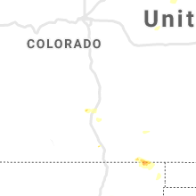

Cities Most Affected by Hail Storms of 8/29/2020
| Hail Size | Demographics of Zip Codes Affected | ||||||
|---|---|---|---|---|---|---|---|
| City | Count | Average | Largest | Pop Density | House Value | Income | Age |
| Amarillo, TX | 2 | 1.88 | 2.00 | 77 | $76k | $36.5k | 39.6 |
| Booneville, AR | 1 | 1.75 | 1.75 | 28 | $56k | $28.6k | 40.4 |
Hail and Wind Damage Spotted on 8/29/2020
Filter by Report Type:Hail ReportsWind Reports
States Impacted
Kansas, Missouri, Maryland, Arkansas, New York, New Mexico, Colorado, Kentucky, Pennsylvania, Tennessee, Vermont, Virginia, Texas, Massachusetts, South Dakota, Wyoming, Oklahoma, ArizonaKansas
| Local Time | Report Details |
|---|---|
| 7:31 AM CDT | Spotter estimates wind gusts of 60 mph or higher. several small tree limbs down. hail just below dime size occurring as wel in montgomery county KS, 48.7 miles SSW of Chanute, KS |
| 7:58 AM CDT | Estimated 55 to 60 mph winds. small tree limbs down. report via twitte in montgomery county KS, 28.9 miles S of Chanute, KS |
| 8:07 AM CDT | Peak wind gust at the chanute airpor in neosho county KS, 1.8 miles WSW of Chanute, KS |
| 8:07 AM CDT | Delayed report. several reports of tree and power line damage in neosho county including galesburg... erie... and saint pau in neosho county KS, 15.5 miles SSE of Chanute, KS |
| 8:31 AM CDT | Home weather station measured 64.6 mph gus in crawford county KS, 34.9 miles ESE of Chanute, KS |
| 8:32 AM CDT | 60 mph gusts estimated in western part of county by sheriff deput in cherokee county KS, 43.2 miles SSE of Chanute, KS |
| 8:32 AM CDT | Estimated by deput in cherokee county KS, 38 miles SE of Chanute, KS |
| 8:33 AM CDT | Delayed report. widespread tree and power line damage in a narrow corridor from saint paul to the crawford county line. damage to an outbuilding was noted as wel in neosho county KS, 20.9 miles ESE of Chanute, KS |
| 8:39 AM CDT | Power lines down on south ozark stree in crawford county KS, 35.8 miles ESE of Chanute, KS |
| 8:46 AM CDT | Preliminary damage in frontenac appears to be straight line winds. several large healthy tree limbs into structures. over a dozen structures with roof damage from tree in crawford county KS, 44.8 miles ESE of Chanute, KS |
| 8:48 AM CDT | Power line and utility pole dow in crawford county KS, 44 miles ESE of Chanute, KS |
| 8:52 AM CDT | Storm damage reported in crawford county KS, 44.8 miles ESE of Chanute, KS |
| 8:52 AM CDT | 12 inch diameter limb down. power outages also reported in frontenac and arm in crawford county KS, 43.8 miles ESE of Chanute, KS |
| 9:10 AM CDT | Delayed report near arcadia. estimated 60-70 mph winds. power pole snapped near the base at the corner of s main st and w walnut st. another set of lines taken out by a in barton county MO, 45.7 miles E of Chanute, KS |
Missouri
| Local Time | Report Details |
|---|---|
| 9:04 AM CDT | Tree downe in jasper county MO, 62.8 miles W of Springfield, MO |
| 9:10 AM CDT | Tree downe in jasper county MO, 54 miles W of Springfield, MO |
| 9:15 AM CDT | Utility pole down in the city of jaspe in jasper county MO, 56.3 miles W of Springfield, MO |
| 9:27 AM CDT | Home weather station reported 59.2 mph gus in barton county MO, 57.8 miles WNW of Springfield, MO |
| 9:30 AM CDT | Numerous trees... limbs and power lines down throughout the city of lamar. damage to booths and equipment in downtown lamar at the fai in barton county MO, 57.8 miles WNW of Springfield, MO |
| 9:46 AM CDT | Report of power lines down in mille in lawrence county MO, 29.7 miles W of Springfield, MO |
| 10:19 AM CDT | Tree down on e 7th st in cassville. another tree down blocking farm road 2180 and farm road 114 in barry county MO, 48.5 miles SW of Springfield, MO |
| 10:20 AM CDT | Walnut grove fire estimates 60 mph gust in greene county MO, 20.7 miles NW of Springfield, MO |
| 10:24 AM CDT | Sgf aso in greene county MO, 5.8 miles WNW of Springfield, MO |
| 10:27 AM CDT | Corrects previous tstm wnd gst report from 5 sse willard. sgf aso in greene county MO, 5.8 miles WNW of Springfield, MO |
| 10:35 AM CDT | Couple of 6 inch diameter tree limbs downed near downtown walnut grov in greene county MO, 19.5 miles NW of Springfield, MO |
| 10:54 AM CDT | Sgf airport. 51kts at 1554 ut in greene county MO, 5.8 miles WNW of Springfield, MO |
| 10:54 AM CDT | Large maple tree snapped low on the trunk on north bristol ave. in northeastern springfield... mo. time estimated from rada in greene county MO, 5.1 miles E of Springfield, MO |
| 11:22 AM CDT | Several tree limbs downed 4 to 8 inches in diamete in webster county MO, 17 miles ENE of Springfield, MO |
| 11:25 AM CDT | Large limbs blocking most of road at james river bridge on hwy b south of northvie in webster county MO, 16.5 miles ENE of Springfield, MO |
| 11:26 AM CDT | Report via social media. multiple large tree limbs blown down. also structural damage ranging from garage doors to outbuildings being blown over. time estimated from ra in webster county MO, 24.5 miles E of Springfield, MO |
| 11:40 AM CDT | Picture of a large tree limb that fell onto a parked car in ava... mo. time estimated from rada in douglas county MO, 39.2 miles ESE of Springfield, MO |
| 12:18 PM CDT | Preliminary damage reported across mountain grove south of hwy 60. a grocery store awning damaged. a carwash room collapsed on a vehicle. several trees down. minor or n in wright county MO, 52.1 miles SW of Salem, MO |
| 12:33 PM CDT | Picture on social media relayed via media partner of a storage trailer blown onto its side as well as some shingles torn off in cabool. time estimated from rada in texas county MO, 47.3 miles SW of Salem, MO |
Maryland
| Local Time | Report Details |
|---|---|
| 1:54 PM EDT | Public reported 5 large trees blown down approx 5 miles south of church cree in dorchester county MD, 59.3 miles W of Ocean City, MD |
Arkansas
| Local Time | Report Details |
|---|---|
| 1:40 PM CDT | Storm damage reported in van buren county AR, 44.8 miles N of Little Rock, AR |
| 2:40 PM CDT | Several trees blown down along highway 2 in lawrence county AR, 90.4 miles NW of Memphis, TN |
| 2:40 PM CDT | Multiple trees reported down in the lynn are in lawrence county AR, 90 miles NW of Memphis, TN |
| 2:53 PM CDT | Initial report of some trees dow in lawrence county AR, 87.7 miles NW of Memphis, TN |
| 3:05 PM CDT | Several trees and power lines were blown down. wind gust up to 70 mph was reporte in lawrence county AR, 77.3 miles NW of Memphis, TN |
| 6:14 PM CDT | Golf Ball sized hail reported near Booneville, AR, 29.2 miles SE of Fort Smith, AR, golfball sized hail reported at the intersection of highways 23 and 71. |
| 7:20 PM CDT | Ping Pong Ball sized hail reported near Fort Smith, AR, 6 miles SSE of Fort Smith, AR |
| 8:21 PM CDT | Scott county sheriff's office reported trees down over hwy 28 blocking the roa in scott county AR, 34 miles SSE of Fort Smith, AR |
| 8:25 PM CDT | Power lines down in sebastian county AR, 13.4 miles S of Fort Smith, AR |
| 8:50 PM CDT | Several trees were downed by thunderstorm winds in and around men in polk county AR, 49 miles NNW of Nashville, AR |
| 8:52 PM CDT | A tree fell on power lines in mena and started a fire on petros ave near the mena high schoo in polk county AR, 49 miles NNW of Nashville, AR |
| 10:10 PM CDT | Large tree blocking ar highway 26 near the ar highway 369 intersectio in howard county AR, 6.5 miles NNW of Nashville, AR |
| 10:15 PM CDT | Large tree down on mt. pleasant road in the chapel hill community north of nashvill in howard county AR, 3.8 miles NNW of Nashville, AR |
| 10:30 PM CDT | Multiple trees down across the city of nashvill in howard county AR, 0.6 miles SSW of Nashville, AR |
| 10:35 PM CDT | Power lines and electric poles down west of nashville on highway 371 west. power outages reported near the intersection of highway 371 and highway 26 and in between nas in howard county AR, 1.3 miles W of Nashville, AR |
| 10:40 PM CDT | Reports of multiple trees down in horati in sevier county AR, 29.5 miles W of Nashville, AR |
| 10:40 PM CDT | Trees down on central rd... ar-24 and fox view... and ar-32 in sevier county AR, 24 miles W of Nashville, AR |
| 11:25 PM CDT | Branches down on power lines leading to power outages in ashdown. light pole down on south wallace d in little river county AR, 25.1 miles SW of Nashville, AR |
| 11:27 PM CDT | Trees down on red bluff rd/lr-7 in little river county AR, 22.1 miles SSW of Nashville, AR |
New York
| Local Time | Report Details |
|---|---|
| 4:19 PM EDT | Ping Pong Ball sized hail reported near Broadalbin, NY, 22.1 miles NW of Schenectady, NY |
| 4:32 PM EDT | Ping Pong Ball sized hail reported near Galway, NY, 17.5 miles NNW of Schenectady, NY |
| 4:37 PM EDT | Trees down in otsego county NY, 43.7 miles W of Schenectady, NY |
| 4:42 PM EDT | Wires down on boyhaven road in saratoga county NY, 19.9 miles N of Schenectady, NY |
| 4:44 PM EDT | One foot diameter tree snapped at jockey street and galway road in saratoga county NY, 14.6 miles N of Schenectady, NY |
| 4:49 PM EDT | Trees down in otsego county NY, 41.1 miles W of Schenectady, NY |
| 6:01 PM EDT | Trees across road. damage to power pole in otsego county NY, 64.6 miles WSW of Schenectady, NY |
| 6:30 PM EDT | Tree down on route 10 in jefferso in schoharie county NY, 41.1 miles SW of Schenectady, NY |
| 6:38 PM EDT | Trees across winnie hill road in otsego county NY, 61.7 miles WSW of Schenectady, NY |
| 6:45 PM EDT | Wires down in hagu in warren county NY, 52.1 miles SSW of Burlington, VT |
| 6:56 PM EDT | Trees across highway 10 in delaware county NY, 44.4 miles SW of Schenectady, NY |
| 6:57 PM EDT | Tree and wires down on a house on east river drive in warren county NY, 32.1 miles N of Schenectady, NY |
| 7:00 PM EDT | Trees and wires down in schenectady. also minor street floodin in schenectady county NY, 1 miles SSE of Schenectady, NY |
| 7:10 PM EDT | Tree down in the town of lexingto in greene county NY, 43.7 miles SSW of Schenectady, NY |
New Mexico
| Local Time | Report Details |
|---|---|
| 2:22 PM MDT | Downed powerline in colfax county NM, 69.2 miles E of Taos, NM |
| 2:25 PM MDT | Krtn aso in colfax county NM, 63.6 miles ENE of Taos, NM |
Colorado
| Local Time | Report Details |
|---|---|
| 2:23 PM MDT | Quarter sized hail reported near Pueblo, CO, 20.5 miles SSW of Pueblo, CO, i-25 and mm77. one inch hail reported. |
| 3:54 PM MDT | Asos station kcag craig-moffat county airpor in moffat county CO, 1.8 miles ESE of Craig, CO |
Kentucky
| Local Time | Report Details |
|---|---|
| 3:30 PM CDT | Tree down on highway 240 woodburn allen springs road just beyond the bridge on the allen county side. time estimated using rada in allen county KY, 52 miles NNE of Nashville, TN |
| 3:41 PM CDT | Tree down in southwest park subdivision. time estimated using rada in allen county KY, 50.6 miles NE of Nashville, TN |
| 3:45 PM CDT | Tree down on unoccupied car at the intersection of old hartsville road and stovall road. time estimated using rada in allen county KY, 50.2 miles NE of Nashville, TN |
| 3:50 PM CDT | Low lying roads floode in allen county KY, 51.8 miles NE of Nashville, TN |
Pennsylvania
| Local Time | Report Details |
|---|---|
| 5:25 PM EDT | Trees down reported at 78 mountain road... orangeville p in columbia county PA, 40.5 miles WSW of Scranton, PA |
| 6:35 PM EDT | Tree down on wires along berger creek roa in carbon county PA, 43.7 miles S of Scranton, PA |
| 6:40 PM EDT | Downed trees and wires near picnic woods road. time estimated from rada in carbon county PA, 43.9 miles S of Scranton, PA |
| 6:49 PM EDT | Downed trees and wires near doe lane and buck lane. time estimated from rada in monroe county PA, 33.8 miles SSE of Scranton, PA |
| 7:10 PM EDT | Trees dow in northampton county PA, 55.9 miles SSE of Scranton, PA |
| 7:15 PM EDT | Trees dow in northampton county PA, 54.8 miles SSE of Scranton, PA |
| 7:17 PM EDT | Downed power lines near bradford street. time estimated from rada in lehigh county PA, 57.7 miles S of Scranton, PA |
| 7:20 PM EDT | Downed trees and wires near ridgeview drive. time estimated from rada in lehigh county PA, 62.2 miles S of Scranton, PA |
Tennessee
| Local Time | Report Details |
|---|---|
| 5:10 PM CDT | Twitter tspotter report of a tree down over a road on hwy 12 near shady grove road by the fredonia onestop marke in montgomery county TN, 31 miles NW of Nashville, TN |
Vermont
| Local Time | Report Details |
|---|---|
| 7:13 PM EDT | Large tree down on vt route 30 in rutland county VT, 48.1 miles S of Burlington, VT |
Virginia
| Local Time | Report Details |
|---|---|
| 7:38 PM EDT | Multiple trees down along owens d in king george county VA, 65.3 miles NNE of Richmond, VA |
Texas
| Local Time | Report Details |
|---|---|
| 7:01 PM CDT | Trees and power lines down along fm 730 in bria in wise county TX, 46.7 miles WNW of Dallas, TX |
| 7:02 PM CDT | Significant damage to a structure along briar rd in azle. possible microburs in tarrant county TX, 45.1 miles WNW of Dallas, TX |
| 7:02 PM CDT | Multiple structures damaged in briar. possible microburst indicated on rada in wise county TX, 45.4 miles WNW of Dallas, TX |
| 7:02 PM CDT | Significant damage with injuries south of briar along fm 730 near briar rd. damage reported at an rv park with a picture of a flipped rv. strong downburst signature on in parker county TX, 45.7 miles WNW of Dallas, TX |
| 7:31 PM CDT | Multiple large trees down along woodhaven driv in tarrant county TX, 25.3 miles WNW of Dallas, TX |
| 7:32 PM CDT | Large tree limbs down at briardale and briarwoo in tarrant county TX, 25.1 miles WNW of Dallas, TX |
| 7:32 PM CDT | Significant tree damage associated with 50 mph at the nws fort worth office in n fort wort in tarrant county TX, 29.6 miles W of Dallas, TX |
| 7:43 PM CDT | Ping Pong Ball sized hail reported near Boys Ranch, TX, 18.8 miles NW of Amarillo, TX, hail reported on fm 1061. |
| 7:49 PM CDT | Multiple fences blown down in wataug in tarrant county TX, 29.1 miles WNW of Dallas, TX |
| 7:53 PM CDT | Quarter sized hail reported near Amarillo, TX, 7.1 miles NW of Amarillo, TX, late report of quarter size hail reported with time estimated from radar. |
| 7:55 PM CDT | Damage to a 2-story home near n beach st and heritage trace pkwy. shingles lost... and siding peeled off. damage to fence and large tree snapped. report from social med in tarrant county TX, 30.4 miles WNW of Dallas, TX |
| 8:04 PM CDT | Collapsed workshop building pictured near loop 335 and willow creek r in potter county TX, 5 miles N of Amarillo, TX |
| 8:07 PM CDT | Golf Ball sized hail reported near Amarillo, TX, 3.6 miles N of Amarillo, TX, roof blown off home and golf ball size hail. time estimated from radar. |
| 8:07 PM CDT | Roof blown off home and golf ball size hail. time estimated from rada in potter county TX, 3.6 miles N of Amarillo, TX |
| 8:07 PM CDT | Quarter sized hail reported near Amarillo, TX, 3.1 miles NNW of Amarillo, TX, late social media report of quarter size hail with time estimated from radar. |
| 8:07 PM CDT | Late report of travel trailer damage...fences blown over...power lines blown down and metal sheds destroyed due to thunderstorm wind gusts. time estimated from rada in potter county TX, 3.7 miles NNW of Amarillo, TX |
| 8:08 PM CDT | Quarter sized hail reported near Boys Ranch, TX, 22 miles NW of Amarillo, TX, late report of quarter size hail. |
| 8:08 PM CDT | Quarter sized hail reported near Amarillo, TX, 7.1 miles NW of Amarillo, TX, accumulating hail severe inches deep. |
| 8:13 PM CDT | Wind shield was damaged... sideways blown hail. trained spotter estimated 70 mph wind gus in potter county TX, 6.4 miles N of Amarillo, TX |
| 8:13 PM CDT | Hen Egg sized hail reported near Amarillo, TX, 6.4 miles N of Amarillo, TX, wind shield was damaged... sideways blown hail. trained spotter estimated 70 mph wind gust. |
| 8:15 PM CDT | Numerous 3 to 5 inch diameter trees limbs down. time estimated from rada in potter county TX, 3 miles NNE of Amarillo, TX |
| 8:15 PM CDT | Quarter sized hail reported near Amarillo, TX, 5 miles N of Amarillo, TX, accumulating hail... and large tree blown into home in north amarillo. |
| 8:15 PM CDT | Accumulating hail... and large tree blown into home in north amarill in potter county TX, 5 miles N of Amarillo, TX |
| 8:15 PM CDT | Ping Pong Ball sized hail reported near Amarillo, TX, 4.3 miles N of Amarillo, TX, wind blown ping pong ball size hail blew out north facing windows...with winds destroying a 16 foot trampoline. time estimated from radar. |
| 8:15 PM CDT | Wind blown ping pong ball size hail blew out north facing windows...with winds destroying a 16 foot trampoline. time estimated from rada in potter county TX, 4.3 miles N of Amarillo, TX |
| 8:15 PM CDT | Ping Pong Ball sized hail reported near Amarillo, TX, 4.4 miles N of Amarillo, TX, late picture received of hail covering the ground up to 5 inches deep. time estimated from radar and nearby reports. |
| 8:21 PM CDT | Late report of siding from house torn of building and vent on roof damaged due to blowing debris. time estimated from rada in potter county TX, 6.6 miles ENE of Amarillo, TX |
| 8:21 PM CDT | Multiple downed trees in northeast amarill in potter county TX, 5.1 miles NE of Amarillo, TX |
| 8:21 PM CDT | Downed power lines and fence blown over at loop 335 and amarillo blvd in northeast amarilo in potter county TX, 5.4 miles E of Amarillo, TX |
| 8:21 PM CDT | Train was blown over near the intersection of u.s. highway 60 and farm-to-market 191 in potter county TX, 10.8 miles ENE of Amarillo, TX |
| 8:21 PM CDT | Corrected location...train was blown over with possible 80 to 90 mph wind gust. also...tree snapped in half and laying across roadwa in carson county TX, 13.4 miles ENE of Amarillo, TX |
| 8:21 PM CDT | Corrected location...train was blown over with possible 80 to 90 mph wind gust. also...tree snapped in half and laying across roadwa in potter county TX, 12.6 miles ENE of Amarillo, TX |
| 8:22 PM CDT | Storm damage reported in potter county TX, 6.5 miles E of Amarillo, TX |
| 8:28 PM CDT | Half Dollar sized hail reported near Hereford, TX, 31.8 miles SW of Amarillo, TX |
| 8:49 PM CDT | Wind farm with 10 meter wind sensor reported 61 mph wind gus in carson county TX, 37.5 miles ENE of Amarillo, TX |
| 8:49 PM CDT | Corrected location...wind farm with 10 meter wind sensor reported 61 mph wind gus in carson county TX, 31.7 miles ENE of Amarillo, TX |
| 9:15 PM CDT | Large portions of a roof blown off home several trees were downed. time estimated from rada in carson county TX, 41 miles E of Amarillo, TX |
| 9:30 PM CDT | West texas mesonet reported 61 mph wind gus in gray county TX, 56 miles ENE of Amarillo, TX |
| 9:30 PM CDT | West texas mesonet reported 61 mph wind gus in gray county TX, 56 miles ENE of Amarillo, TX |
| 9:38 PM CDT | West texas mesonet in gray county TX, 52.9 miles E of Amarillo, TX |
| 10:15 PM CDT | Storm damage reported in hall county TX, 37.4 miles WNW of Childress, TX |
| 10:25 PM CDT | Storm damage reported in briscoe county TX, 55.9 miles W of Childress, TX |
| 10:37 PM CDT | Storm damage reported in briscoe county TX, 48.5 miles W of Childress, TX |
| 10:55 PM CDT | Storm damage reported in hall county TX, 41.2 miles W of Childress, TX |
| 11:45 PM CDT | West texas mesonet report in briscoe county TX, 48.5 miles W of Childress, TX |
| 2:03 AM CDT | Storm damage reported in wichita county TX, 4.9 miles N of Wichita Falls, TX |
| 2:04 AM CDT | Storm damage reported in wichita county TX, 10.7 miles NNW of Wichita Falls, TX |
| 2:18 AM CDT | Storm damage reported in wichita county TX, 4.9 miles N of Wichita Falls, TX |
| 2:47 AM CDT | Storm damage reported in clay county TX, 15.1 miles E of Wichita Falls, TX |
Massachusetts
| Local Time | Report Details |
|---|---|
| 8:42 PM EDT | Tree and wires downed on shelburne line rd in colrain. time radar estimate in franklin county MA, 66 miles E of Schenectady, NY |
South Dakota
| Local Time | Report Details |
|---|---|
| 7:10 PM MDT | Storm damage reported in pennington county SD, 15 miles W of Rapid City, SD |
| 7:10 PM MDT | Half Dollar sized hail reported near Rapid City, SD, 15 miles W of Rapid City, SD |
| 8:44 PM MDT | Storm damage reported in pennington county SD, 14 miles ESE of Rapid City, SD |
| 10:15 PM MDT | Wind gust from decaying thunderstorm in pennington county SD, 51.3 miles ESE of Rapid City, SD |
Wyoming
| Local Time | Report Details |
|---|---|
| 7:18 PM MDT | Storm damage reported in weston county WY, 45.2 miles W of Rapid City, SD |
Oklahoma
| Local Time | Report Details |
|---|---|
| 8:45 PM CDT | Large branches down in idabe in mccurtain county OK, 56.6 miles W of Nashville, AR |
| 9:30 PM CDT | Large branches down north of broken bo in mccurtain county OK, 57.2 miles WNW of Nashville, AR |
| 1:45 AM CDT | Storm damage reported in tillman county OK, 26.1 miles NNW of Wichita Falls, TX |
| 1:50 AM CDT | Storm damage reported in tillman county OK, 26.1 miles NNW of Wichita Falls, TX |
| 1:55 AM CDT | Storm damage reported in tillman county OK, 26.1 miles NNW of Wichita Falls, TX |
| 2:15 AM CDT | Storm damage reported in comanche county OK, 46.3 miles N of Wichita Falls, TX |
| 2:20 AM CDT | Storm damage reported in cotton county OK, 34.8 miles NNE of Wichita Falls, TX |
| 2:20 AM CDT | Tree down. two metal sheds blown ove in comanche county OK, 40 miles N of Wichita Falls, TX |
| 2:20 AM CDT | 10 in. diameter tree branch dow in comanche county OK, 47.9 miles N of Wichita Falls, TX |
| 2:25 AM CDT | Storm damage reported in cotton county OK, 34.8 miles NNE of Wichita Falls, TX |
| 2:30 AM CDT | Storm damage reported in cotton county OK, 34.8 miles NNE of Wichita Falls, TX |
| 2:45 AM CDT | 6 in. diameter tree branches down. radar estimated tim in jefferson county OK, 32.6 miles ENE of Wichita Falls, TX |
| 2:54 AM CDT | Quarter sized hail reported near Comanche, OK, 44 miles NE of Wichita Falls, TX |
| 3:35 AM CDT | Storm damage reported in love county OK, 71.4 miles E of Wichita Falls, TX |
| 3:40 AM CDT | Storm damage reported in love county OK, 71.4 miles E of Wichita Falls, TX |
Arizona
| Local Time | Report Details |
|---|---|
| 7:40 PM MST | Large 18 in. tree uprooted and fell on house. alma school and riggs r in maricopa county AZ, 22.9 miles SE of Phoenix, AZ |
| 7:46 PM MST | Many trees down across estrella pkwy. estrella pkwy flooded and mostly impassable with 3 in.-2 ft. deep water from elliot rd.... sout in maricopa county AZ, 21.3 miles WSW of Phoenix, AZ |
| 8:00 PM MST | 5 in. tree snapped and numerous branche in maricopa county AZ, 22.3 miles SE of Phoenix, AZ |
Connect with Interactive Hail Maps