

Hail Map for Wednesday, August 4, 2021

Number of Impacted Households on 8/4/2021
0
Impacted by 1" or Larger Hail
0
Impacted by 1.75" or Larger Hail
0
Impacted by 2.5" or Larger Hail
Square Miles of Populated Area Impacted on 8/4/2021
0
Impacted by 1" or Larger Hail
0
Impacted by 1.75" or Larger Hail
0
Impacted by 2.5" or Larger Hail


Cities Most Affected by Hail Storms of 8/4/2021
| Hail Size | Demographics of Zip Codes Affected | ||||||
|---|---|---|---|---|---|---|---|
| City | Count | Average | Largest | Pop Density | House Value | Income | Age |
Hail and Wind Damage Spotted on 8/4/2021
Filter by Report Type:Hail ReportsWind Reports
Washington
| Local Time | Report Details |
|---|---|
| 5:34 AM PDT | Avista utilities reports power outages to approximately 700 customers near orient... w in stevens county WA, 68.3 miles ENE of Omak, WA |
Florida
| Local Time | Report Details |
|---|---|
| 2:58 PM EDT | A wind gust produced by a rapidly building thunderstorm of 58 mph was measured by the mesonet station xtky turkey point before pushing offshore and into biscayne bay. s in miami-dade county FL, 21.7 miles SSW of Miami, FL |
New Mexico
| Local Time | Report Details |
|---|---|
| 4:30 PM MDT | Quarter sized hail reported near Maxwell, NM, 53.2 miles ENE of Taos, NM |
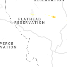
Montana
| Local Time | Report Details |
|---|---|
| 6:48 PM MDT | Quarter sized hail reported near Great Falls, MT, 1.1 miles W of Great Falls, MT, report from mping: quarter (1.00 in.). |
| 6:58 PM MDT | Quarter sized hail reported near Great Falls, MT, 5 miles E of Great Falls, MT |
Oregon
| Local Time | Report Details |
|---|---|
| 6:45 PM PDT | 56 mph at kono airport. reports of multiple trees down and power outage in harney county OR, 18.9 miles W of Burns, OR |
| 7:45 PM MDT | 56 mph at kono airport. reports of multiple trees down and power outage in malheur county OR, 48.2 miles NW of Boise, ID |
| 7:58 PM MDT | Corrects previous tstm wnd gst report from 2 se ontario. mesonet station od142 1.3 w fruitland (odot in malheur county OR, 46.6 miles NW of Boise, ID |
| 8:09 PM MDT | Corrects previous tstm wnd gst report from 7 n vale. mesonet station ts802 alkali fla in malheur county OR, 61.6 miles WNW of Boise, ID |
West Virginia
| Local Time | Report Details |
|---|---|
| 9:50 PM EDT | Trees down in mount clare in harrison county WV, 34 miles NW of Elkins, WV |
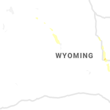
Wyoming
| Local Time | Report Details |
|---|---|
| 8:20 PM MDT | Quarter sized hail reported near Evansville, WY, 3.7 miles ENE of Casper, WY |
| 8:21 PM MDT | Quarter sized hail reported near Evansville, WY, 5.7 miles ENE of Casper, WY |
Connect with Interactive Hail Maps