

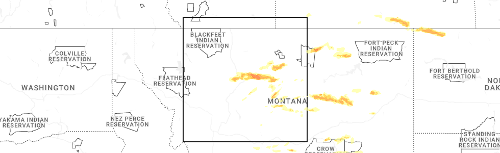
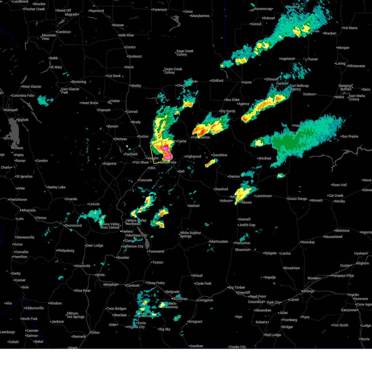
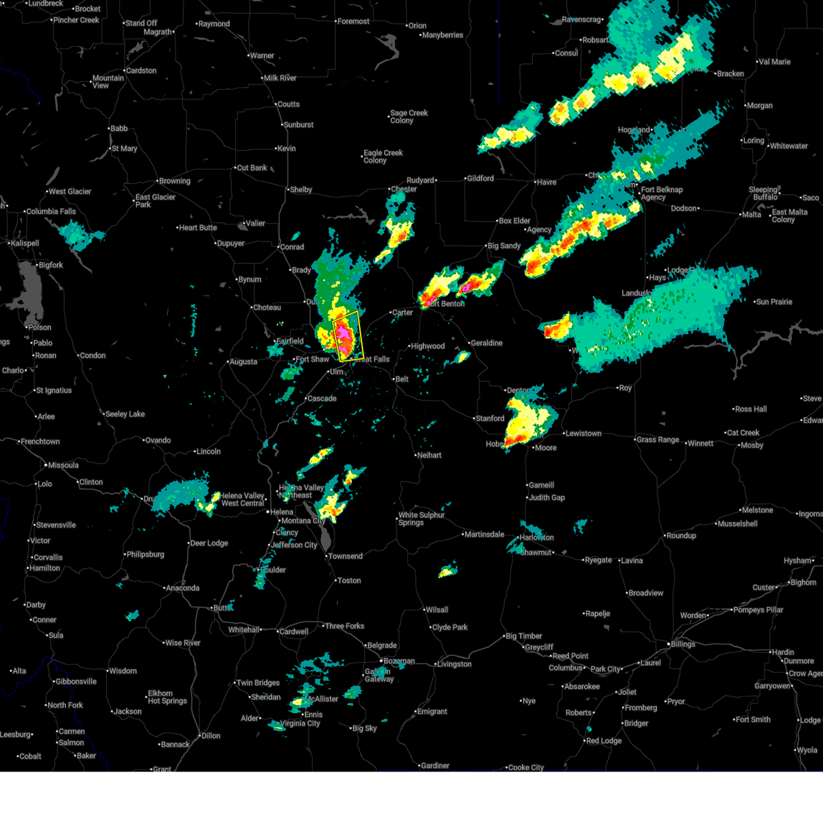
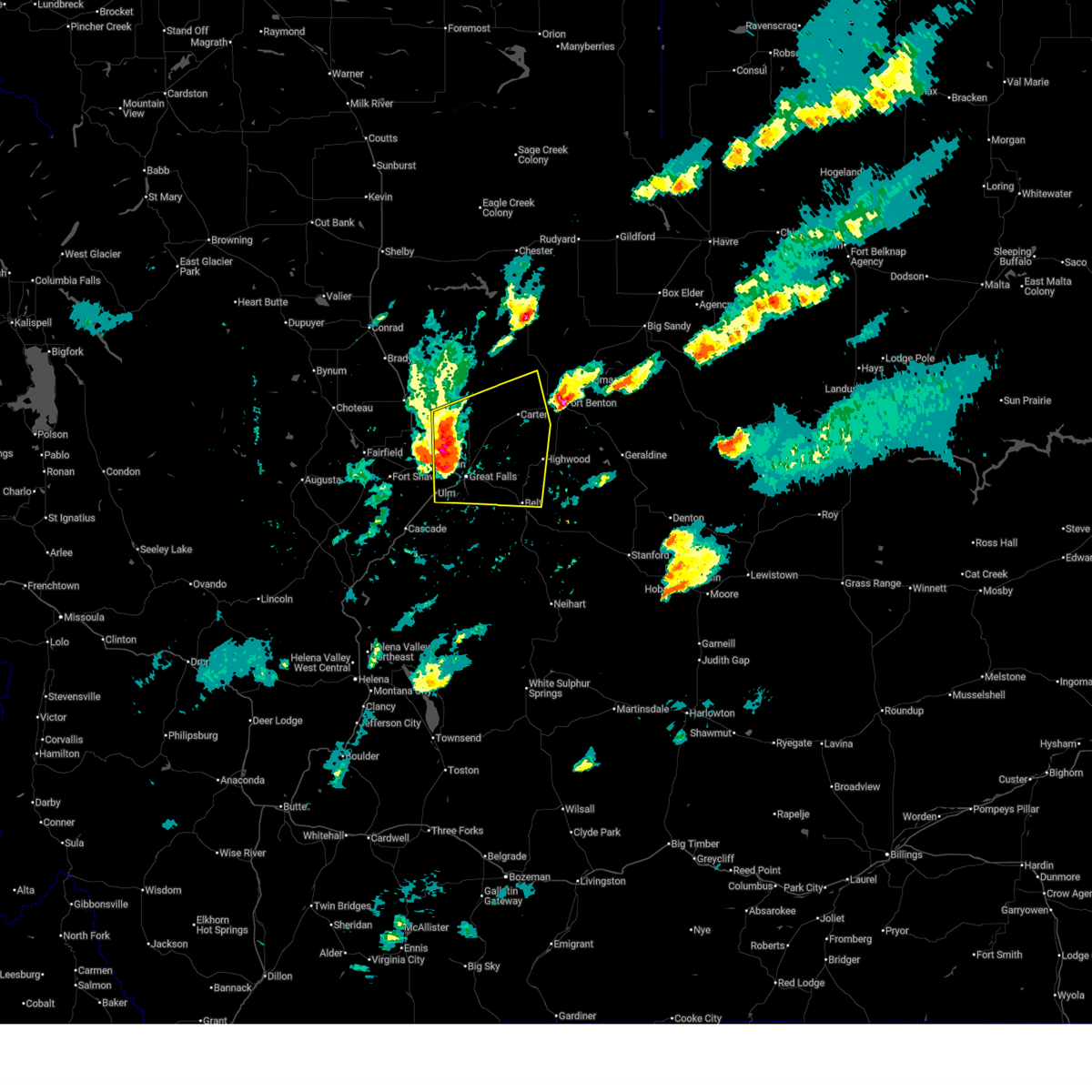
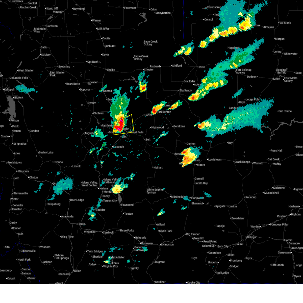
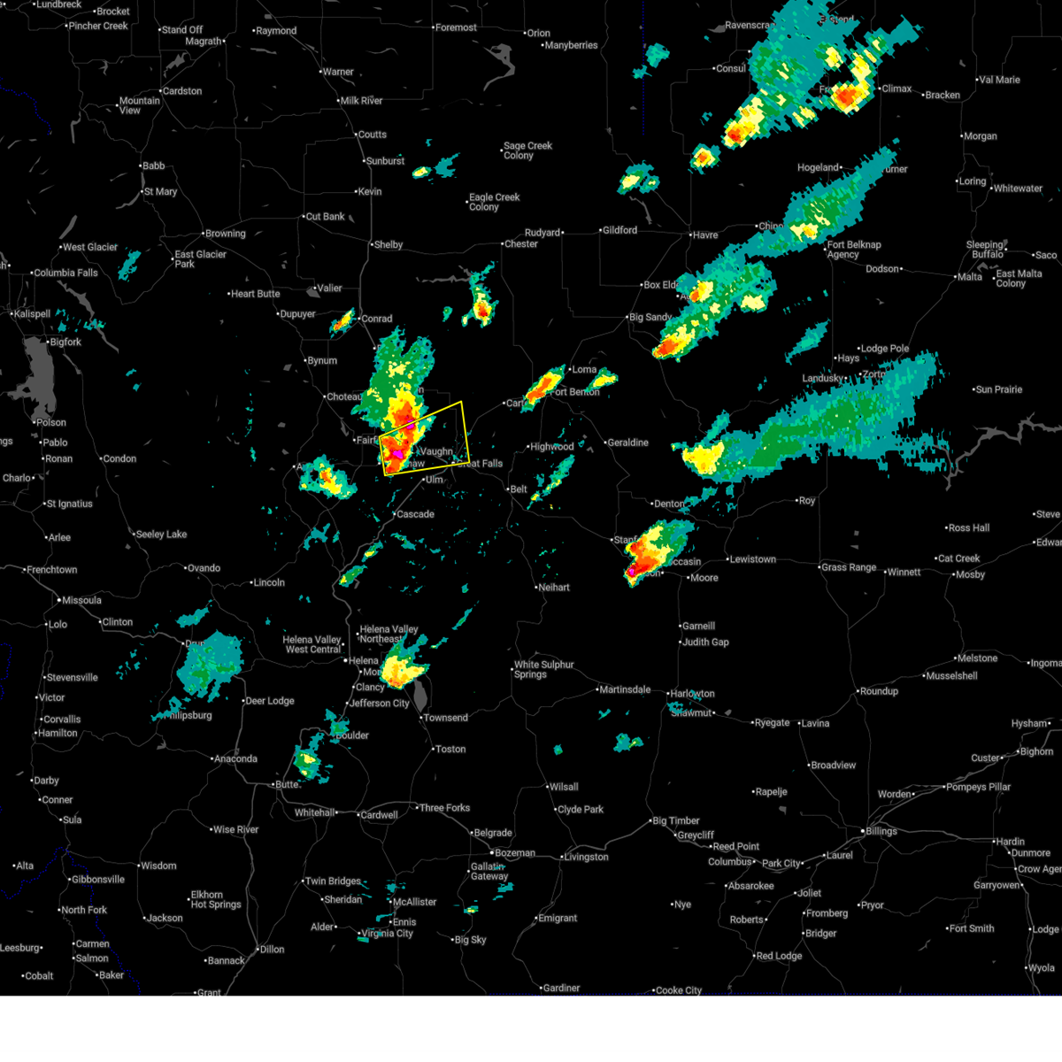
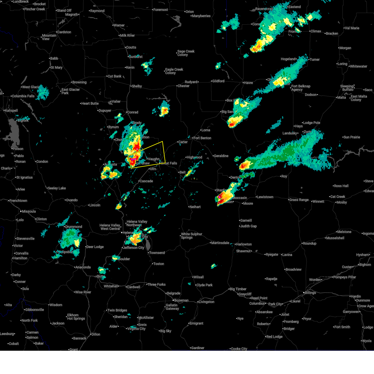
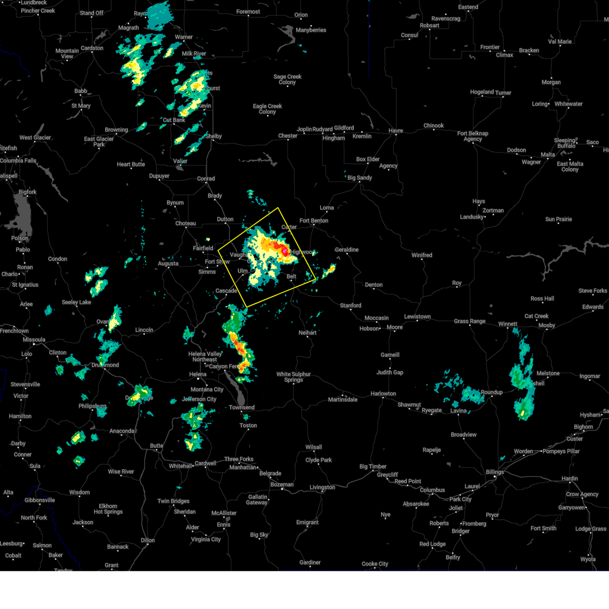
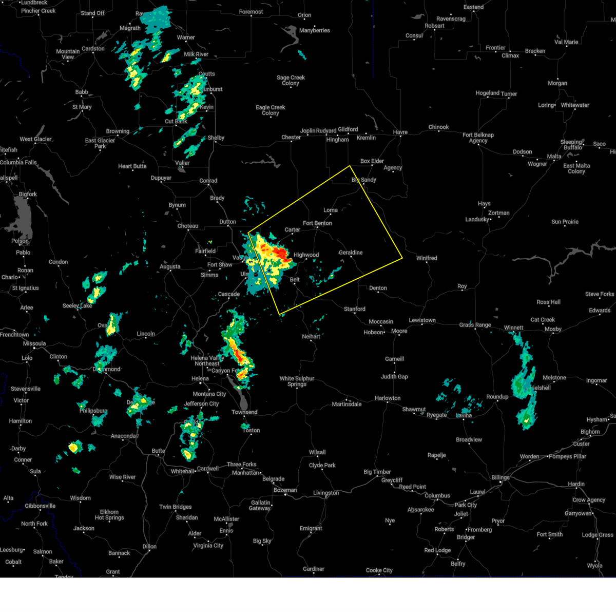
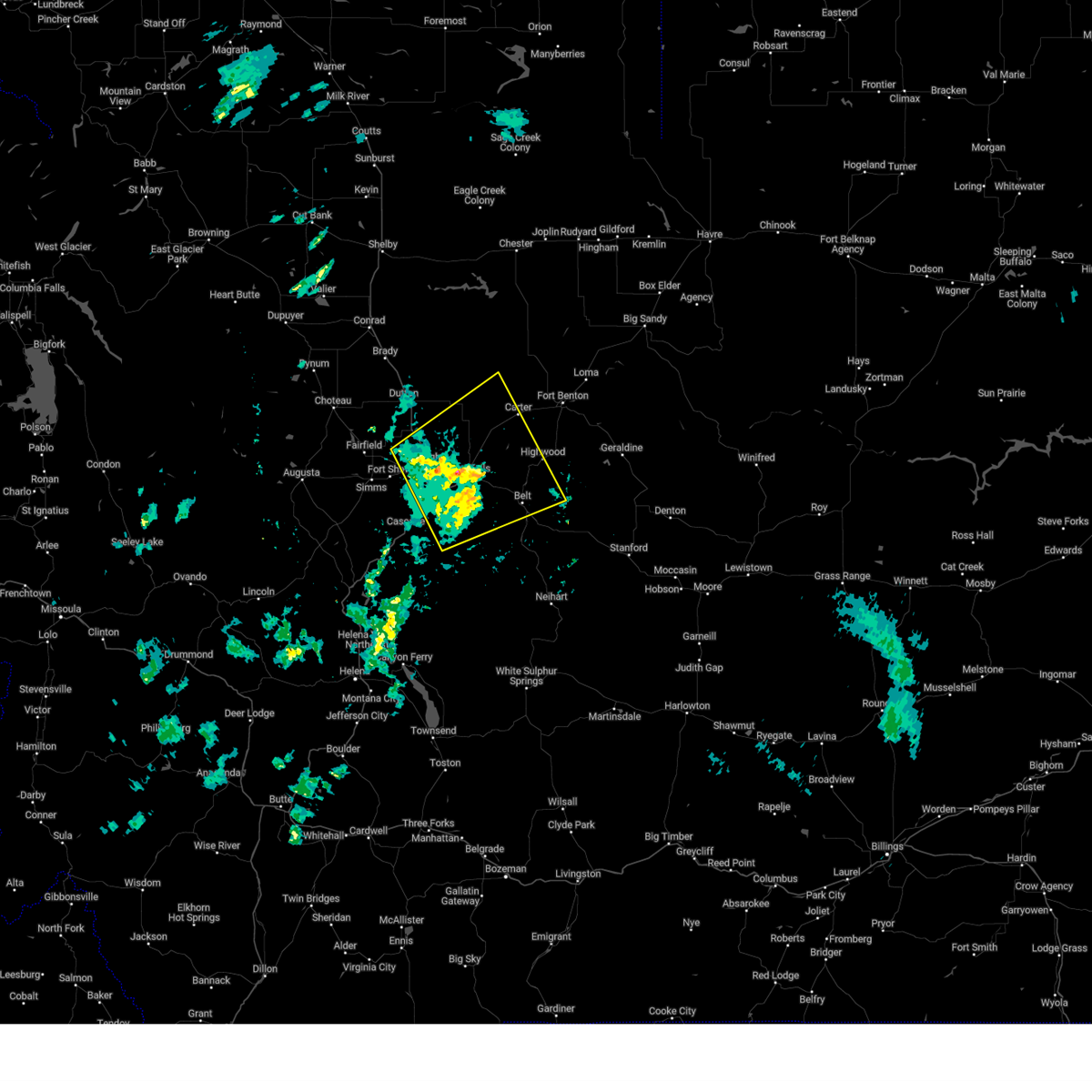
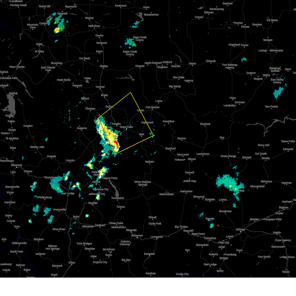
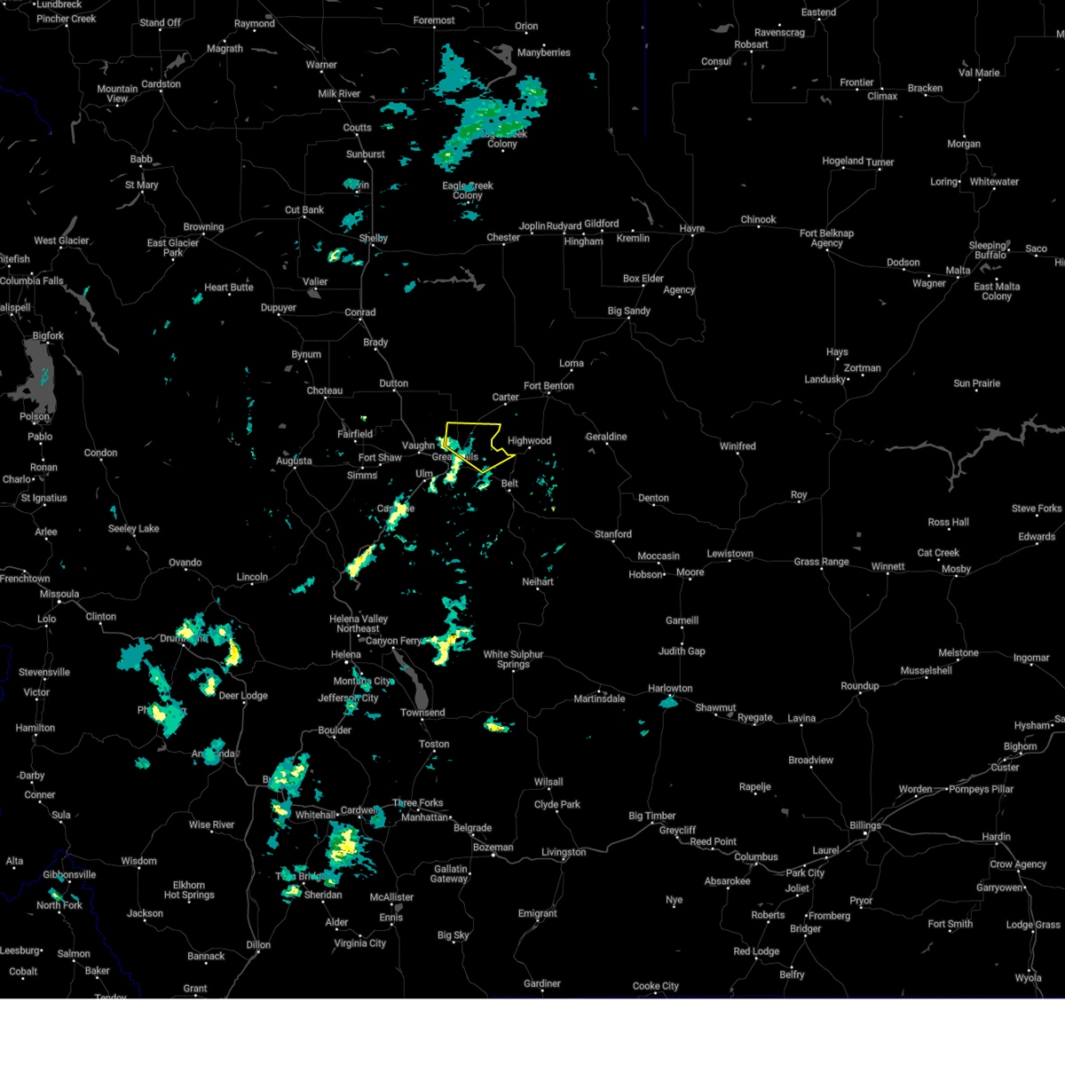
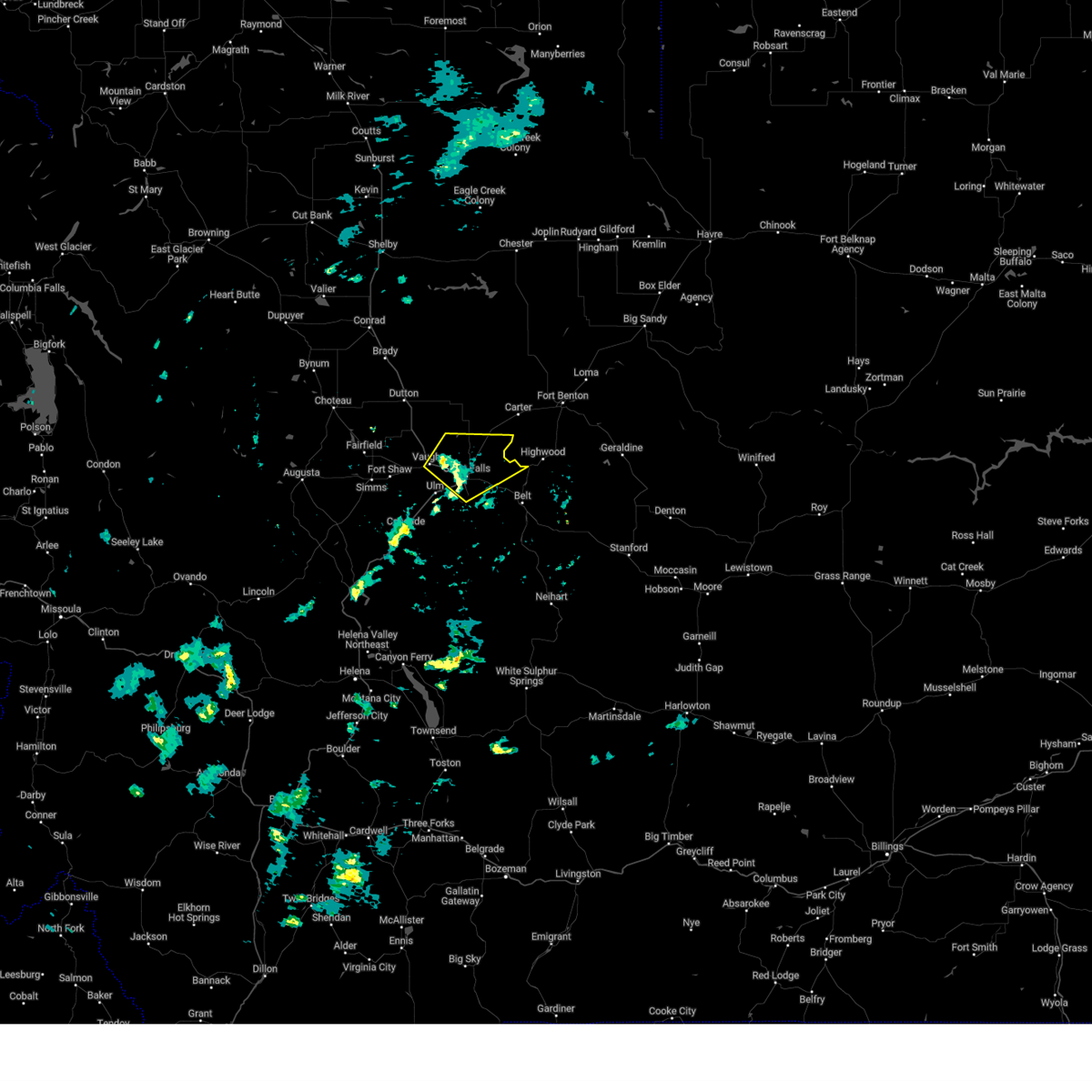
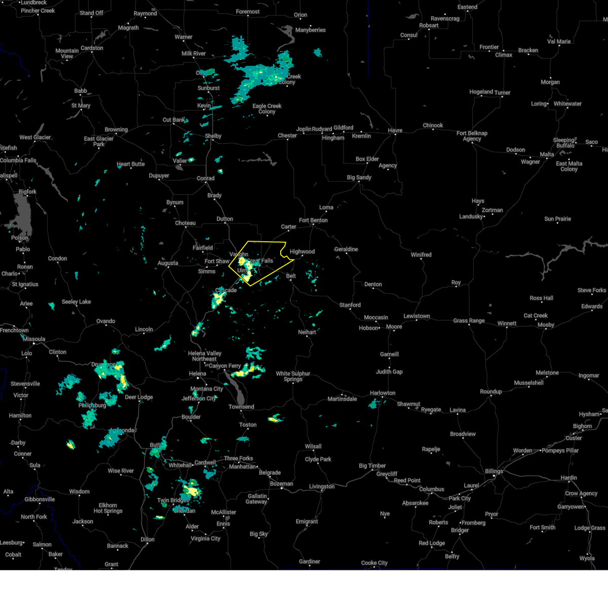
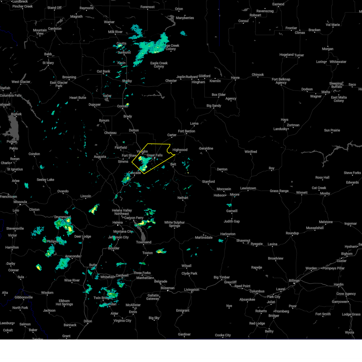
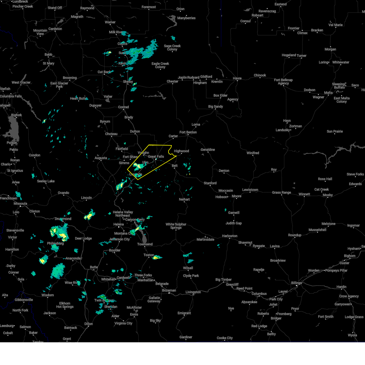
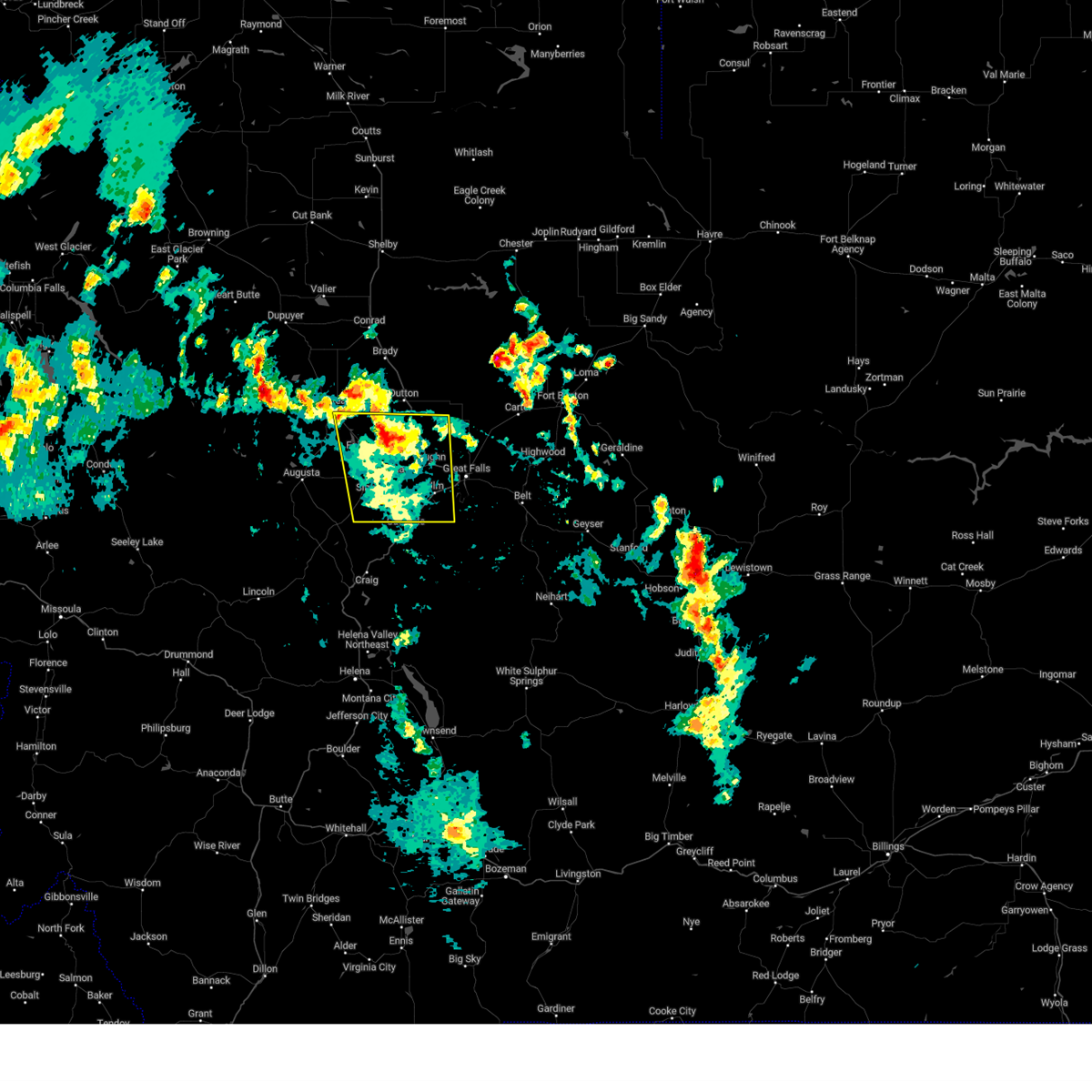
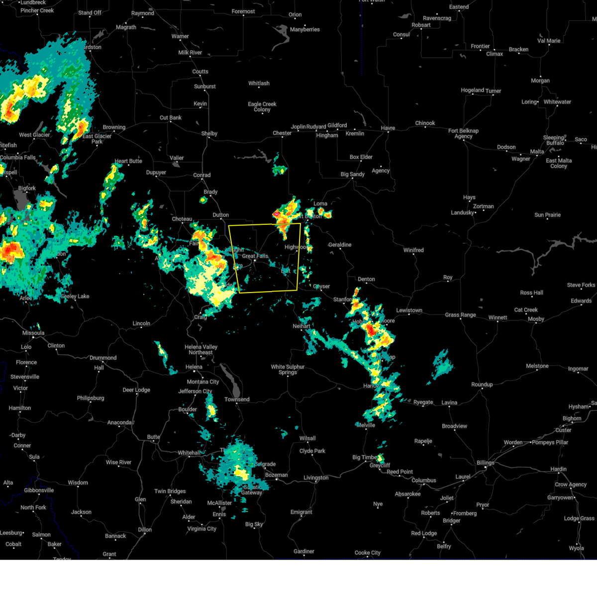
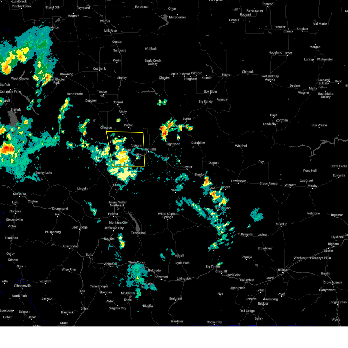
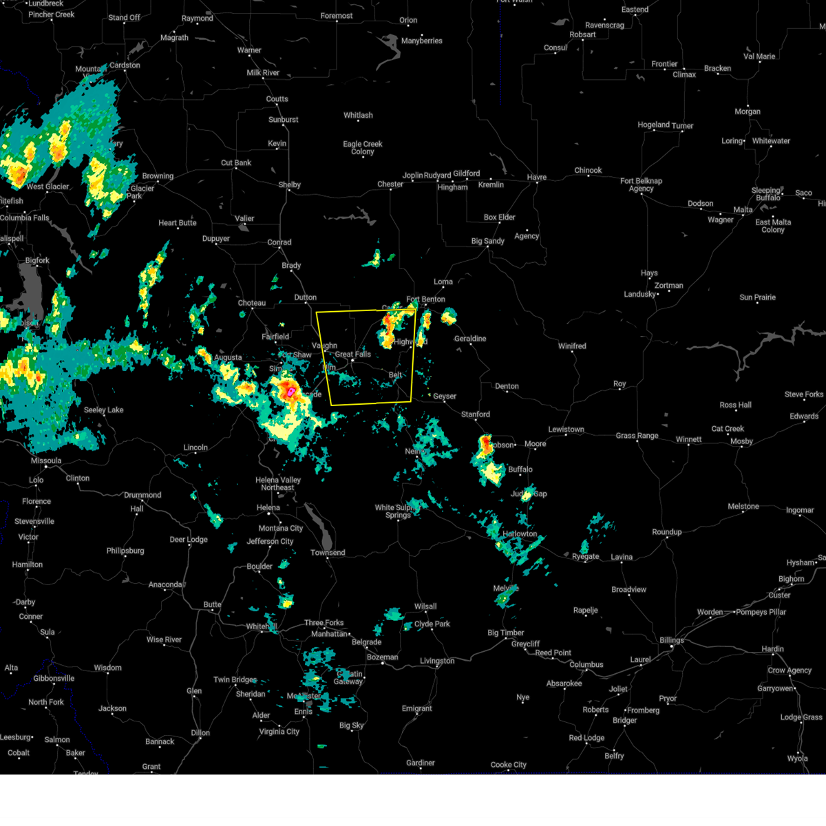
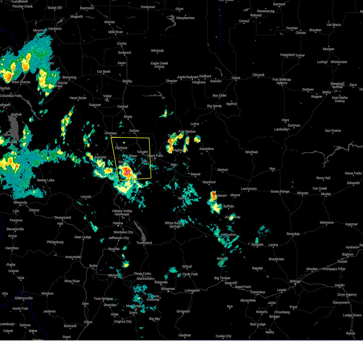
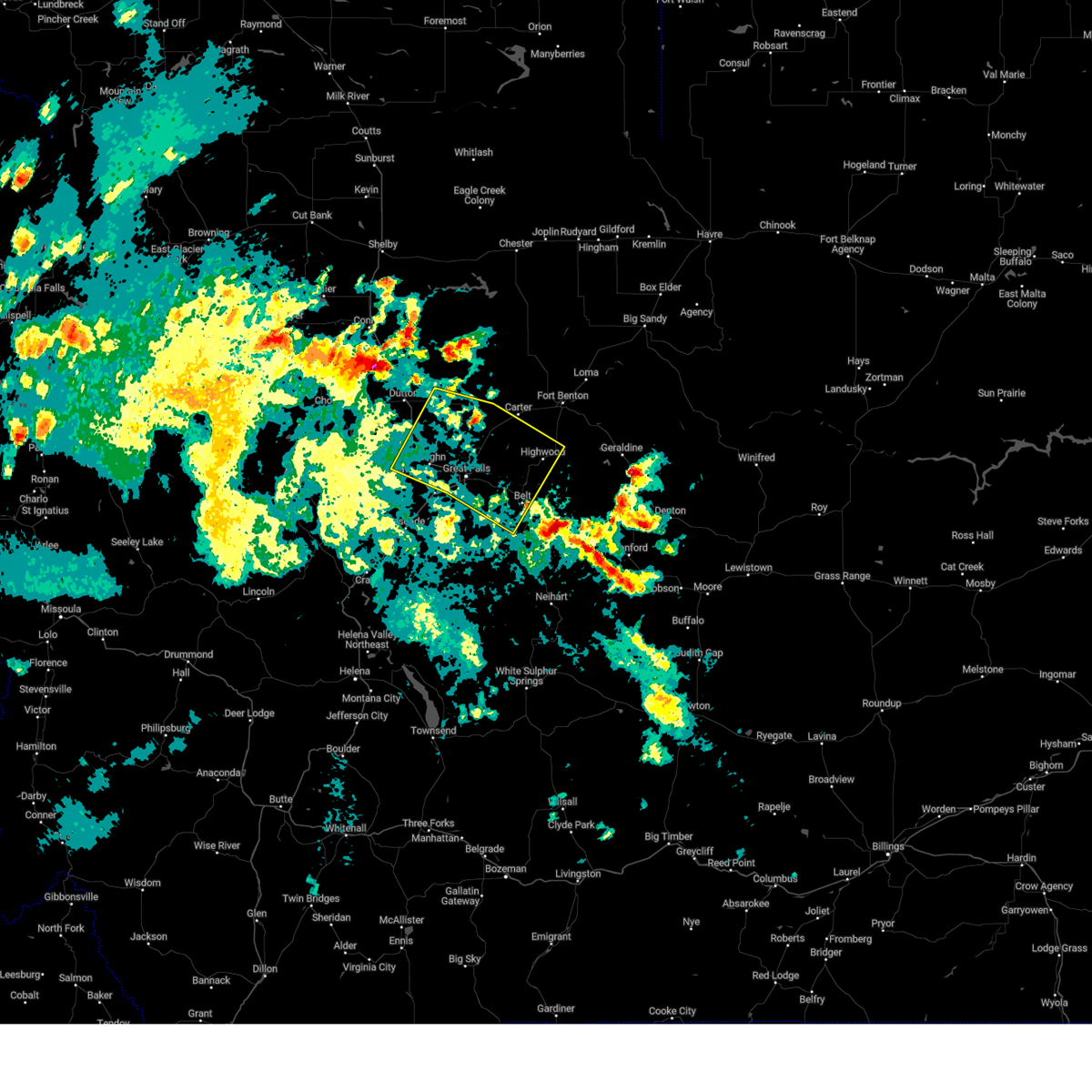
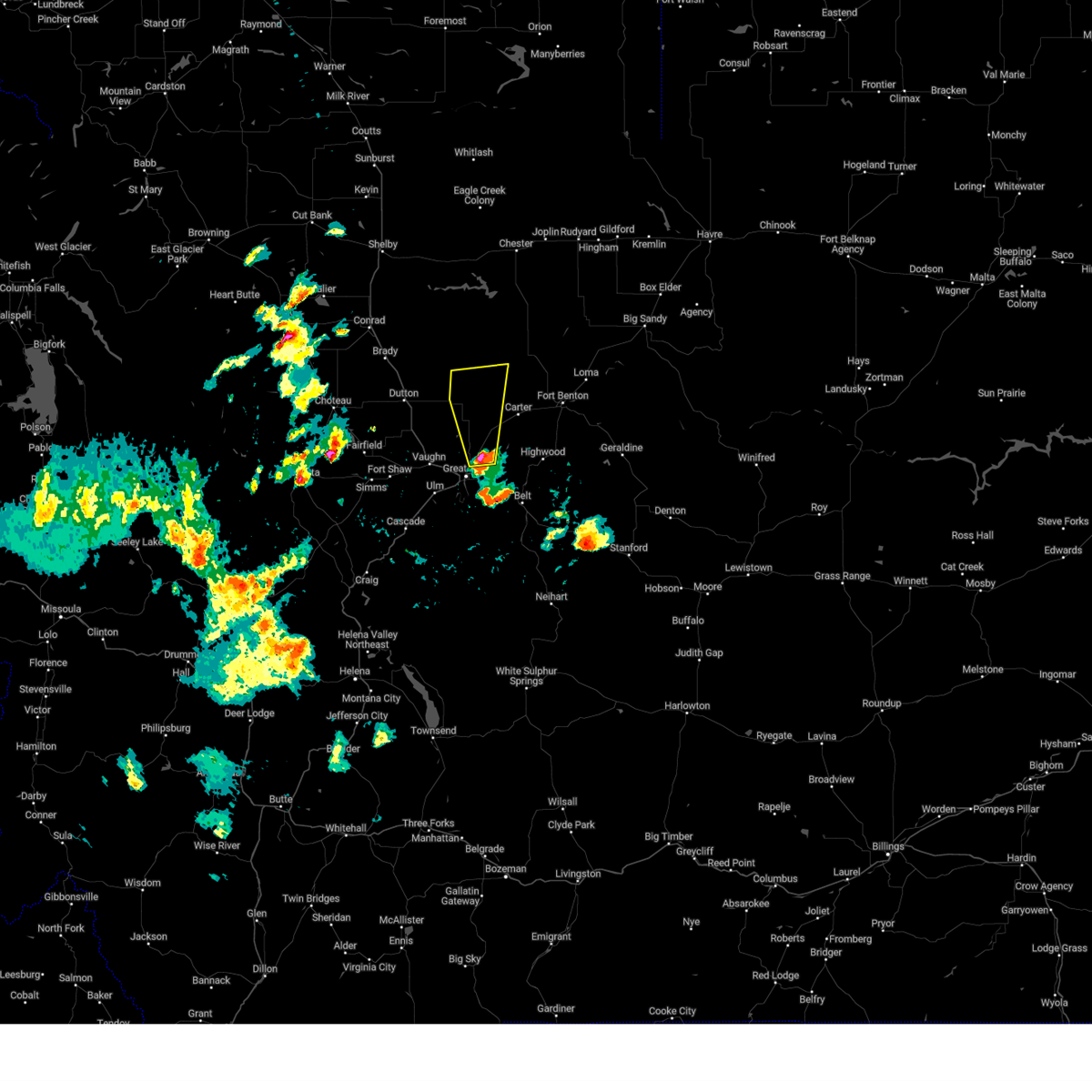
Hail Map for Great Falls, MT
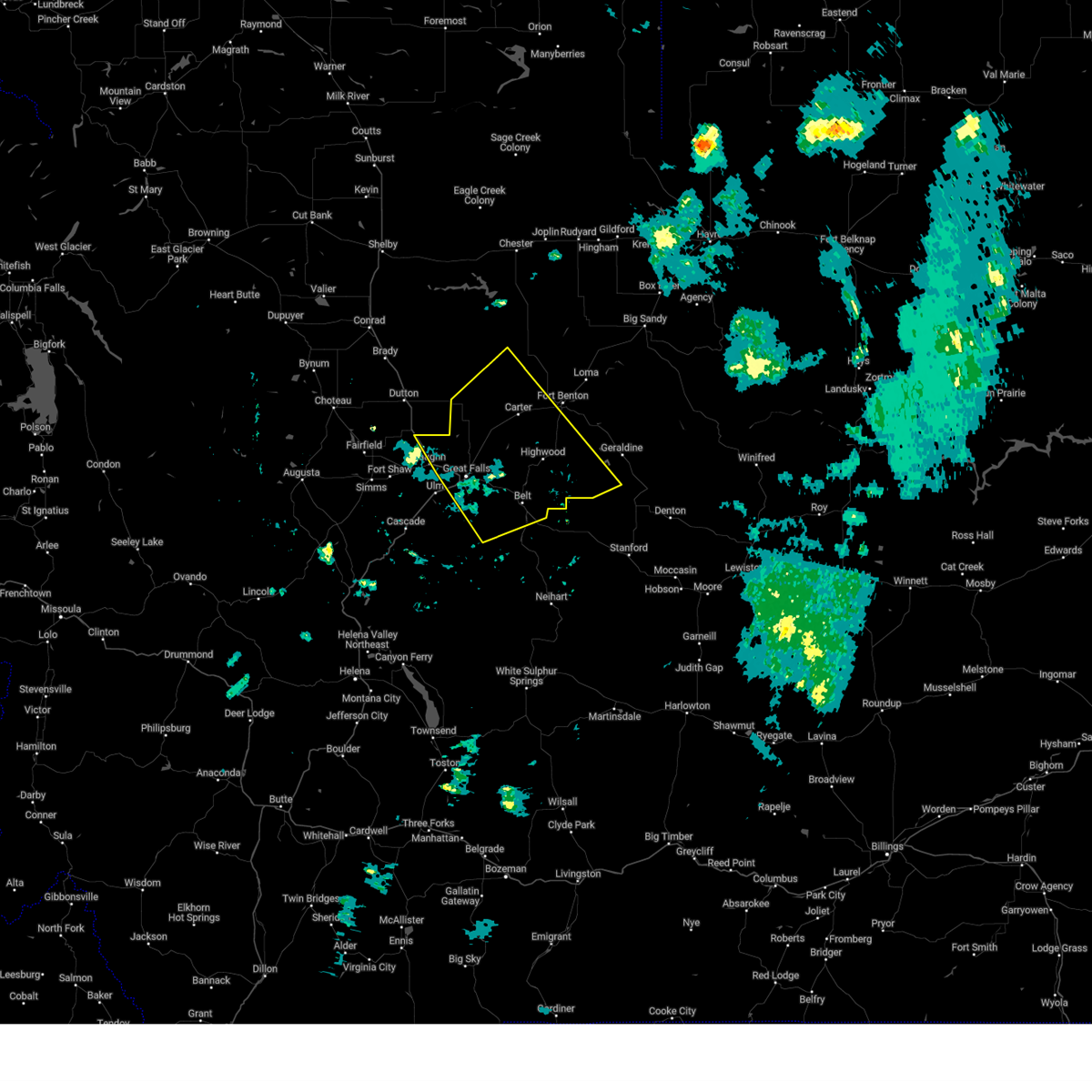
The Great Falls, MT area has had 64 reports of on-the-ground hail by trained spotters, and has been under severe weather warnings 32 times during the past 12 months. Doppler radar has detected hail at or near Great Falls, MT on 32 occasions, including 2 occasions during the past year.
| Name: | Great Falls, MT |
| Where Located: | 0.8 miles ESE of Great Falls, MT |
| Map: | Google Map for Great Falls, MT |
| Population: | 58505 |
| Housing Units: | 26854 |
| More Info: | Search Google for Great Falls, MT |
1
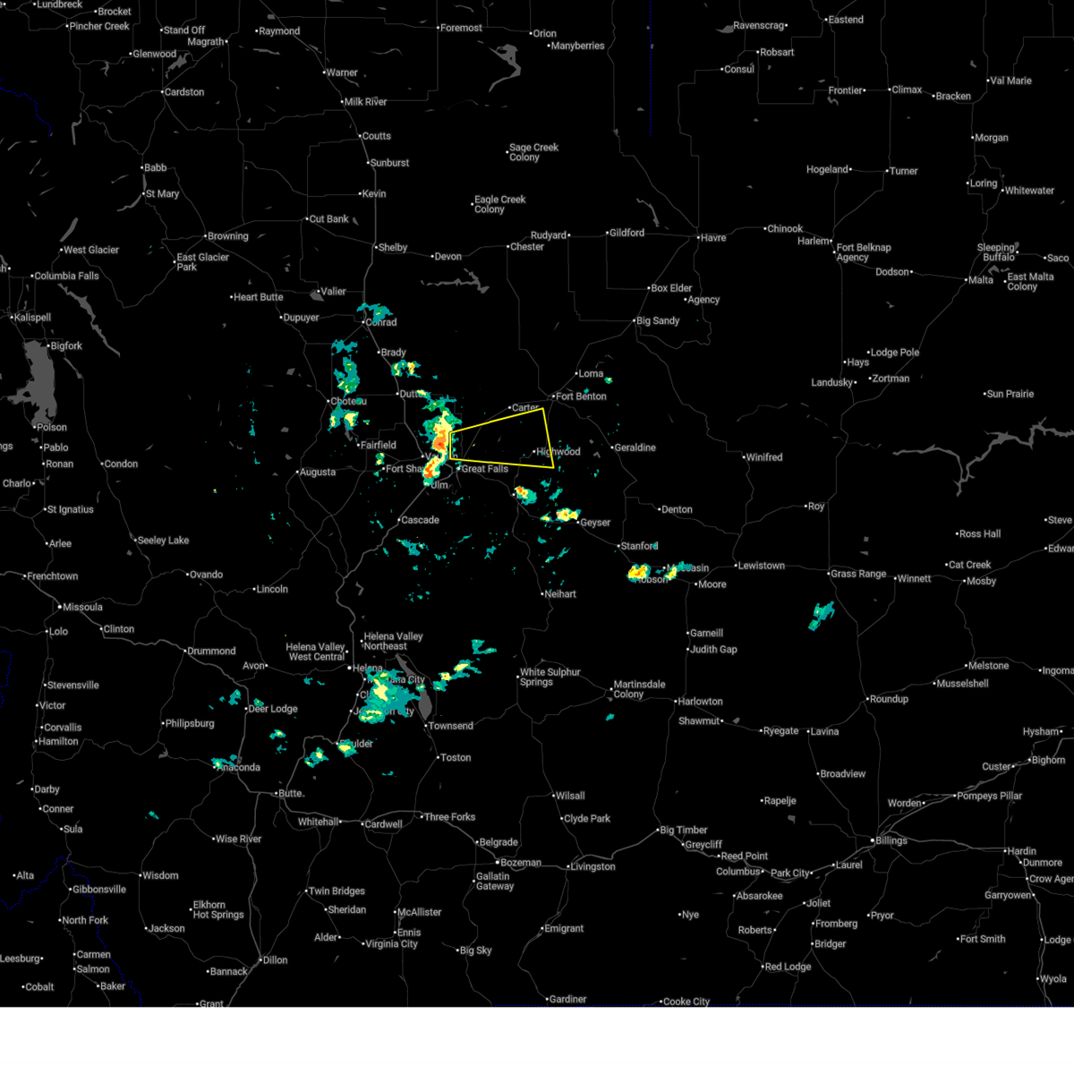
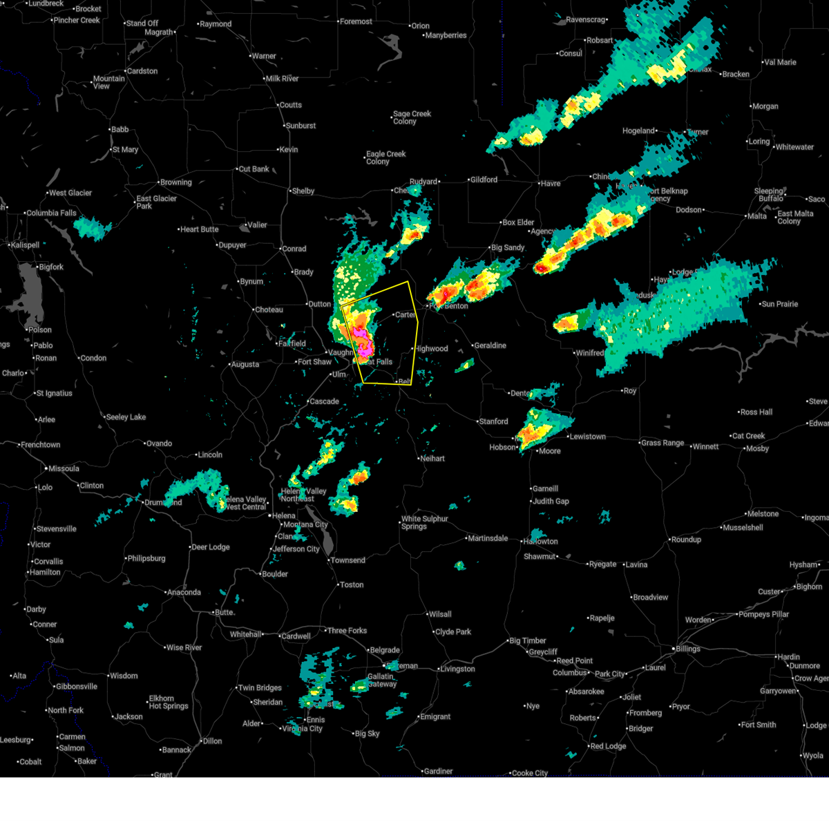
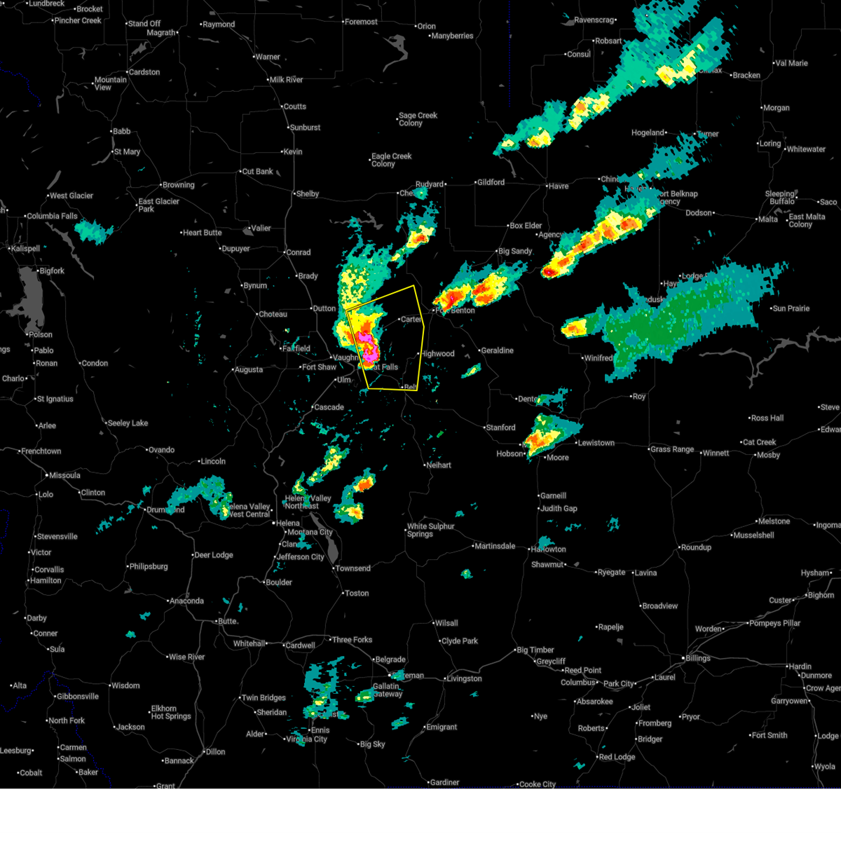
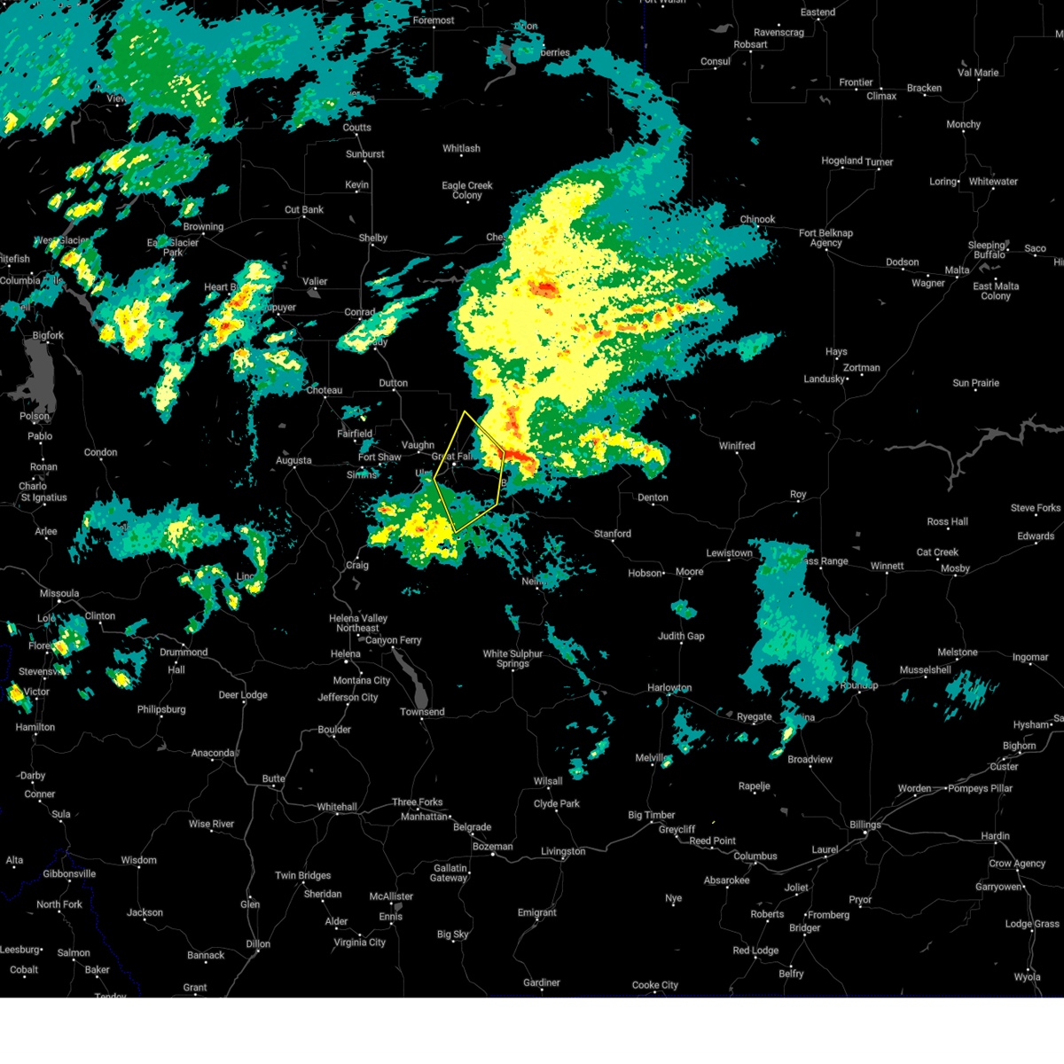
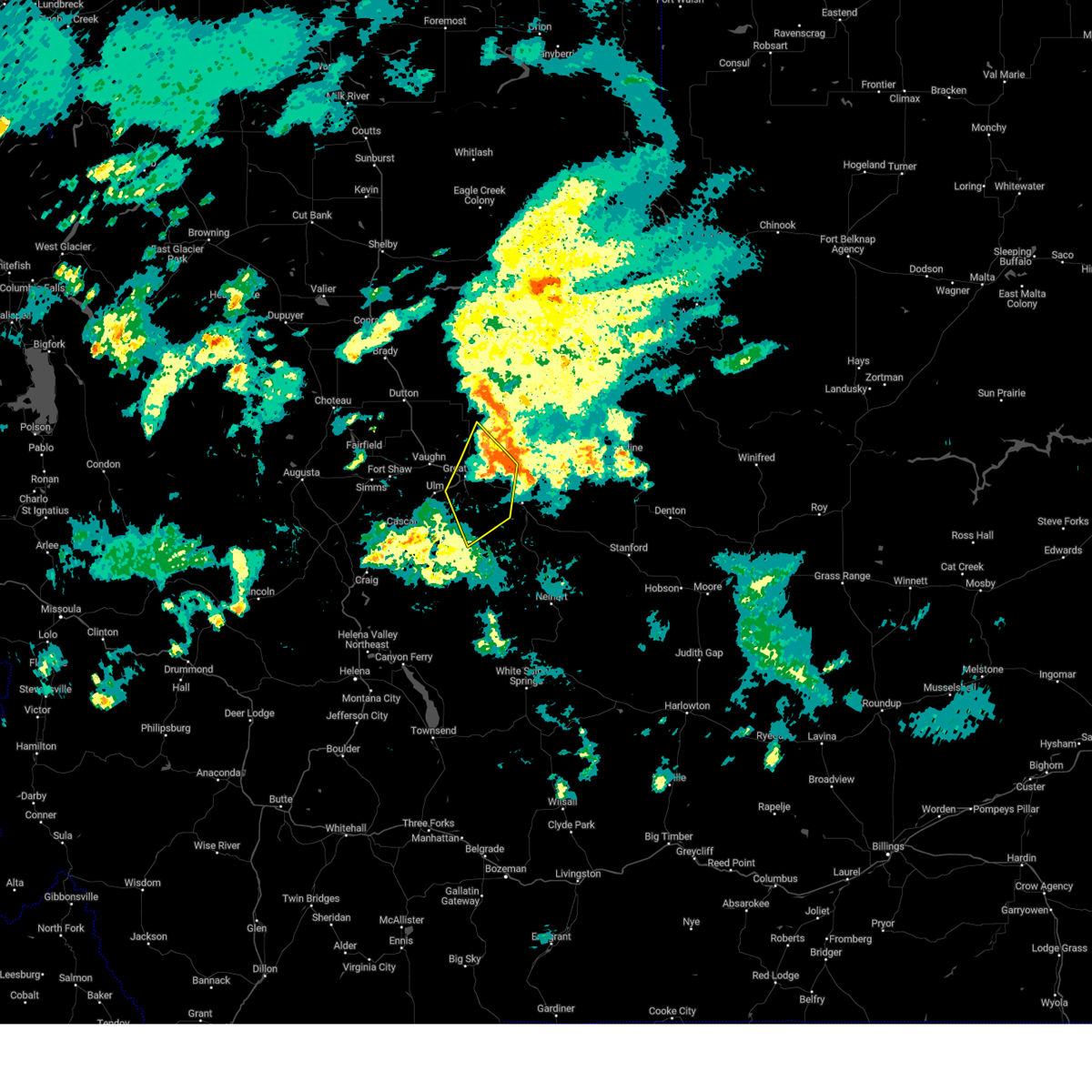
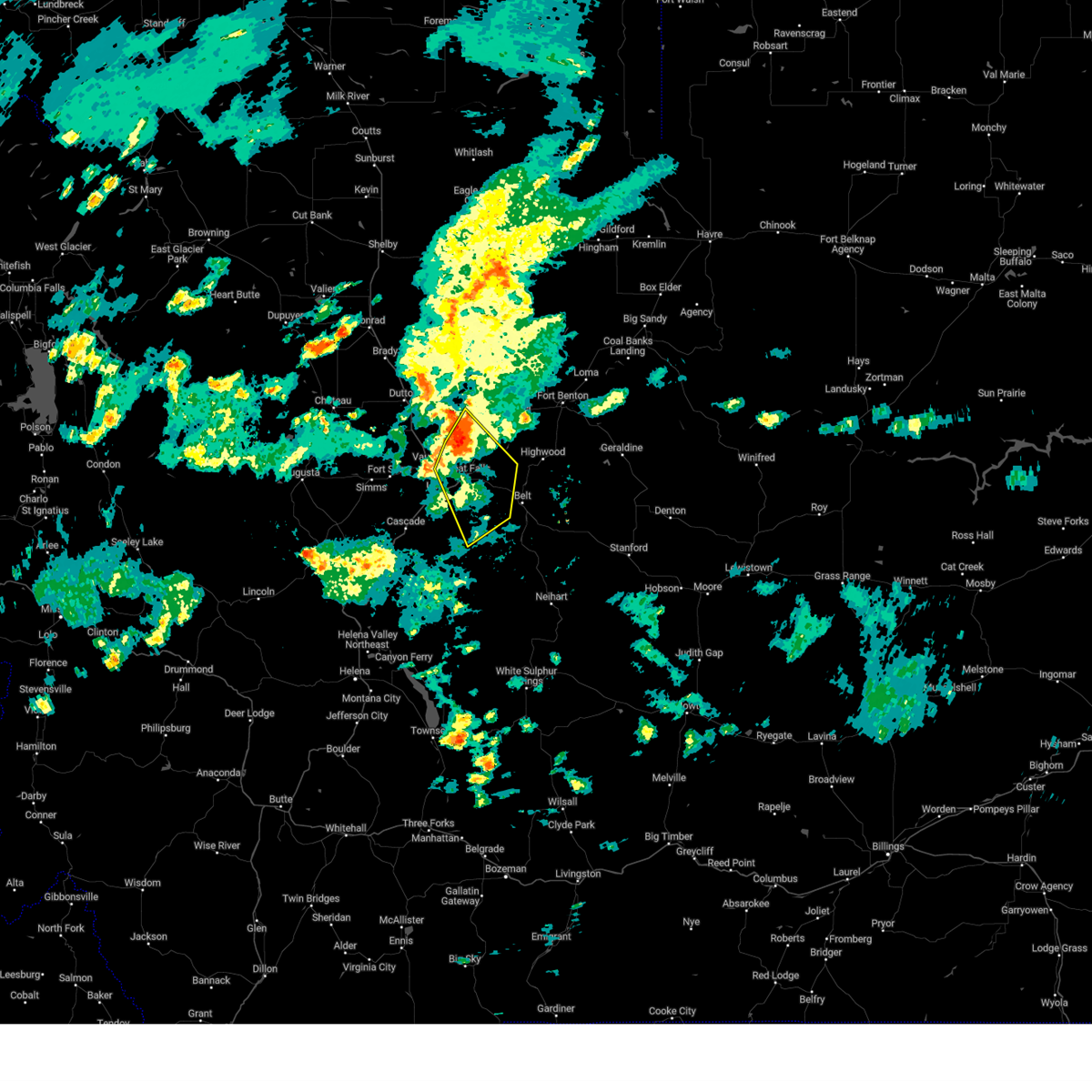
The Top Recent Hail Date for Great Falls, MT is Sunday, June 15, 2025 (5th out of 32)
Hail and Wind Damage Spotted near Great Falls, MT
| Date / Time | Report Details |
|---|---|
| 6/27/2025 1:05 PM MDT |
 Svrtfx the national weather service in great falls has issued a * severe thunderstorm warning for, southwestern chouteau county in north central montana, northeastern cascade county in central montana, * until 145 pm mdt. * at 105 pm mdt, a severe thunderstorm was located near black eagle, or 7 miles north of great falls, moving east at 40 mph (radar indicated). Hazards include 60 mph wind gusts. expect damage to roofs, siding, and trees Svrtfx the national weather service in great falls has issued a * severe thunderstorm warning for, southwestern chouteau county in north central montana, northeastern cascade county in central montana, * until 145 pm mdt. * at 105 pm mdt, a severe thunderstorm was located near black eagle, or 7 miles north of great falls, moving east at 40 mph (radar indicated). Hazards include 60 mph wind gusts. expect damage to roofs, siding, and trees
|
| 6/27/2025 1:01 PM MDT | Public measured a 59 mph wind gusts at 1:01 p in cascade county MT, 7.8 miles SSE of Great Falls, MT |
| 6/15/2025 4:10 PM MDT | Quarter sized hail reported 1.8 miles SE of Great Falls, MT, quarter size hail reported. |
| 6/15/2025 4:10 PM MDT | Quarter sized hail reported 11.3 miles SSW of Great Falls, MT, trained spotter reports quarter size to slightly larger than quarter size hail. |
| 6/15/2025 4:09 PM MDT |
 the severe thunderstorm warning has been cancelled and is no longer in effect the severe thunderstorm warning has been cancelled and is no longer in effect
|
| 6/15/2025 4:09 PM MDT |
 At 409 pm mdt, severe thunderstorms were located along a line extending from 17 miles south of the knees to 12 miles northeast of great falls to near black eagle, moving east at 30 mph (trained weather spotters). Hazards include 60 mph wind gusts and quarter size hail. Hail damage to vehicles is expected. expect wind damage to roofs, siding, and trees. Locations impacted include, great falls, belt, black eagle, highwood, carter, floweree, portage, malmstrom afb, sand coulee, tracy, and centerville. At 409 pm mdt, severe thunderstorms were located along a line extending from 17 miles south of the knees to 12 miles northeast of great falls to near black eagle, moving east at 30 mph (trained weather spotters). Hazards include 60 mph wind gusts and quarter size hail. Hail damage to vehicles is expected. expect wind damage to roofs, siding, and trees. Locations impacted include, great falls, belt, black eagle, highwood, carter, floweree, portage, malmstrom afb, sand coulee, tracy, and centerville.
|
| 6/15/2025 4:08 PM MDT |
 The storm which prompted the warning has moved out of the area. therefore, the warning will be allowed to expire. a severe thunderstorm watch remains in effect until 1100 pm mdt for central and north central montana. remember, a severe thunderstorm warning still remains in effect for cascade county through 430 pm mdt. The storm which prompted the warning has moved out of the area. therefore, the warning will be allowed to expire. a severe thunderstorm watch remains in effect until 1100 pm mdt for central and north central montana. remember, a severe thunderstorm warning still remains in effect for cascade county through 430 pm mdt.
|
| 6/15/2025 4:06 PM MDT | Quarter sized hail reported 1.8 miles S of Great Falls, MT, social media report of 1 inch hail. time and location estimated. |
| 6/15/2025 4:05 PM MDT | Quarter sized hail reported 2.3 miles SE of Great Falls, MT, social media report of three quarter of an inch to an inch sized hail. |
| 6/15/2025 4:01 PM MDT |
 At 401 pm mdt, a severe thunderstorm was located 9 miles north of black eagle, or 10 miles north of great falls, moving east at 30 mph (radar indicated). Hazards include 60 mph wind gusts and quarter size hail. Hail damage to vehicles is expected. expect wind damage to roofs, siding, and trees. Locations impacted include, great falls, black eagle, and malmstrom afb. At 401 pm mdt, a severe thunderstorm was located 9 miles north of black eagle, or 10 miles north of great falls, moving east at 30 mph (radar indicated). Hazards include 60 mph wind gusts and quarter size hail. Hail damage to vehicles is expected. expect wind damage to roofs, siding, and trees. Locations impacted include, great falls, black eagle, and malmstrom afb.
|
| 6/15/2025 4:00 PM MDT | Quarter sized hail reported 1.8 miles S of Great Falls, MT, quarter size hail reported. |
| 6/15/2025 4:00 PM MDT | Quarter sized hail reported 2.3 miles SE of Great Falls, MT, quarter size hail reported. |
| 6/15/2025 4:00 PM MDT | Ping Pong Ball sized hail reported 1.8 miles S of Great Falls, MT, public report with image of ping pong sized hail near north middle school. |
| 6/15/2025 4:00 PM MDT | Quarter sized hail reported 2.2 miles ESE of Great Falls, MT, public report with image of quarter sized hail next to a quarter for reference. |
| 6/15/2025 4:00 PM MDT | Quarter sized hail reported 9.5 miles SSW of Great Falls, MT, trained spotter reports quarter size hail along with 30 to 50 mph winds along highway 87 north of the republic services landfill and south of dent bridge road. |
| 6/15/2025 3:55 PM MDT | Ambient weather statio in cascade county MT, 7.8 miles SSE of Great Falls, MT |
| 6/15/2025 3:49 PM MDT |
 Svrtfx the national weather service in great falls has issued a * severe thunderstorm warning for, eastern teton county in north central montana, southwestern chouteau county in north central montana, northeastern cascade county in central montana, * until 430 pm mdt. * at 349 pm mdt, severe thunderstorms were located along a line extending from 12 miles east of power to 9 miles northwest of black eagle to 7 miles northwest of great falls, moving east at 30 mph (radar indicated). Hazards include 60 mph wind gusts and quarter size hail. Hail damage to vehicles is expected. Expect wind damage to roofs, siding, and trees. Svrtfx the national weather service in great falls has issued a * severe thunderstorm warning for, eastern teton county in north central montana, southwestern chouteau county in north central montana, northeastern cascade county in central montana, * until 430 pm mdt. * at 349 pm mdt, severe thunderstorms were located along a line extending from 12 miles east of power to 9 miles northwest of black eagle to 7 miles northwest of great falls, moving east at 30 mph (radar indicated). Hazards include 60 mph wind gusts and quarter size hail. Hail damage to vehicles is expected. Expect wind damage to roofs, siding, and trees.
|
| 6/15/2025 3:44 PM MDT |
 At 344 pm mdt, a severe thunderstorm was located 11 miles northwest of great falls, moving east at 35 mph (radar indicated). Hazards include 60 mph wind gusts and quarter size hail. Hail damage to vehicles is expected. expect wind damage to roofs, siding, and trees. Locations impacted include, great falls, black eagle, vaughn, first peoples buffalo jump state park, and malmstrom afb. At 344 pm mdt, a severe thunderstorm was located 11 miles northwest of great falls, moving east at 35 mph (radar indicated). Hazards include 60 mph wind gusts and quarter size hail. Hail damage to vehicles is expected. expect wind damage to roofs, siding, and trees. Locations impacted include, great falls, black eagle, vaughn, first peoples buffalo jump state park, and malmstrom afb.
|
| 6/15/2025 3:40 PM MDT | Quarter sized hail reported 2.5 miles S of Great Falls, MT, quarter size hail reported. damage to vehicles and rv reported as well. |
| 6/15/2025 3:33 PM MDT |
 At 333 pm mdt, a severe thunderstorm was located 8 miles northeast of fort shaw, or 17 miles west of great falls, moving east at 30 mph (radar indicated). Hazards include 60 mph wind gusts and quarter size hail. Hail damage to vehicles is expected. expect wind damage to roofs, siding, and trees. Locations impacted include, great falls, black eagle, vaughn, first peoples buffalo jump state park, sun river, and malmstrom afb. At 333 pm mdt, a severe thunderstorm was located 8 miles northeast of fort shaw, or 17 miles west of great falls, moving east at 30 mph (radar indicated). Hazards include 60 mph wind gusts and quarter size hail. Hail damage to vehicles is expected. expect wind damage to roofs, siding, and trees. Locations impacted include, great falls, black eagle, vaughn, first peoples buffalo jump state park, sun river, and malmstrom afb.
|
| 6/15/2025 3:23 PM MDT |
 Svrtfx the national weather service in great falls has issued a * severe thunderstorm warning for, southeastern teton county in north central montana, west central chouteau county in north central montana, northwestern cascade county in central montana, * until 415 pm mdt. * at 322 pm mdt, a severe thunderstorm was located near fort shaw, or 19 miles north of cascade, moving east at 30 mph (trained weather spotters). Hazards include 60 mph wind gusts and half dollar size hail. Hail damage to vehicles is expected. Expect wind damage to roofs, siding, and trees. Svrtfx the national weather service in great falls has issued a * severe thunderstorm warning for, southeastern teton county in north central montana, west central chouteau county in north central montana, northwestern cascade county in central montana, * until 415 pm mdt. * at 322 pm mdt, a severe thunderstorm was located near fort shaw, or 19 miles north of cascade, moving east at 30 mph (trained weather spotters). Hazards include 60 mph wind gusts and half dollar size hail. Hail damage to vehicles is expected. Expect wind damage to roofs, siding, and trees.
|
| 5/11/2025 3:29 PM MDT |
 The storms which prompted the warning have moved out of the area. therefore, the warning will be allowed to expire. remember, a severe thunderstorm warning still remains in effect for eastern portions of cascade and southwestern chouteau counties. The storms which prompted the warning have moved out of the area. therefore, the warning will be allowed to expire. remember, a severe thunderstorm warning still remains in effect for eastern portions of cascade and southwestern chouteau counties.
|
| 5/11/2025 3:27 PM MDT |
 Svrtfx the national weather service in great falls has issued a * severe thunderstorm warning for, northwestern judith basin county in central montana, northwestern fergus county in central montana, eastern teton county in north central montana, south central hill county in north central montana, chouteau county in north central montana, northeastern cascade county in central montana, * until 430 pm mdt. * at 327 pm mdt, severe thunderstorms were located along a line extending from 12 miles southeast of the knees to 8 miles east of belt, moving northeast at 45 mph (radar indicated). Hazards include 60 mph wind gusts. expect damage to roofs, siding, and trees Svrtfx the national weather service in great falls has issued a * severe thunderstorm warning for, northwestern judith basin county in central montana, northwestern fergus county in central montana, eastern teton county in north central montana, south central hill county in north central montana, chouteau county in north central montana, northeastern cascade county in central montana, * until 430 pm mdt. * at 327 pm mdt, severe thunderstorms were located along a line extending from 12 miles southeast of the knees to 8 miles east of belt, moving northeast at 45 mph (radar indicated). Hazards include 60 mph wind gusts. expect damage to roofs, siding, and trees
|
| 5/11/2025 3:20 PM MDT | Corrects previous non-tstm wnd dmg report from 2 sw great falls to tstm wnd dmg. large conifer tree snapped and down on cherry dr in fox farm are in cascade county MT, 2.5 miles NE of Great Falls, MT |
| 5/11/2025 3:09 PM MDT |
 the severe thunderstorm warning has been cancelled and is no longer in effect the severe thunderstorm warning has been cancelled and is no longer in effect
|
| 5/11/2025 3:09 PM MDT |
 At 305 pm mdt, severe thunderstorms were located along a line extending from 9 miles east of power to 10 miles southeast of great falls, moving east at 40 mph (multiple stations reported wind gusts greater than 58 mph). Hazards include 60 mph wind gusts. Expect damage to roofs, siding, and trees. Locations impacted include, floweree, portage, black eagle, eden, malmstrom afb, stockett, tracy, great falls, carter, vaughn, first peoples buffalo jump state park, centerville, sun river, belt, armington, ulm, sand coulee, and highwood. At 305 pm mdt, severe thunderstorms were located along a line extending from 9 miles east of power to 10 miles southeast of great falls, moving east at 40 mph (multiple stations reported wind gusts greater than 58 mph). Hazards include 60 mph wind gusts. Expect damage to roofs, siding, and trees. Locations impacted include, floweree, portage, black eagle, eden, malmstrom afb, stockett, tracy, great falls, carter, vaughn, first peoples buffalo jump state park, centerville, sun river, belt, armington, ulm, sand coulee, and highwood.
|
| 5/11/2025 3:07 PM MDT | 59 mph gust at ambient weather station. (corrected from non-tstm gust to tstm gust) in cascade county MT, 2.3 miles SE of Great Falls, MT |
| 5/11/2025 3:06 PM MDT | 63 mph gust at ambient weather station. (corrected from non-tstm gust to tstm gust) in cascade county MT, 7.8 miles SSE of Great Falls, MT |
| 5/11/2025 3:05 PM MDT | 58 mph gust at ambiient weather station. (corrected from non-tstm gust to tstm gust) in cascade county MT, 6.6 miles S of Great Falls, MT |
| 5/11/2025 2:53 PM MDT | 68 mph gust measured at nws great falls. (corrected from non-tstm gust to tstm gust) in cascade county MT, 5.6 miles ENE of Great Falls, MT |
| 5/11/2025 2:44 PM MDT |
 Svrtfx the national weather service in great falls has issued a * severe thunderstorm warning for, southeastern pondera county in north central montana, southeastern teton county in north central montana, southwestern chouteau county in north central montana, northern cascade county in central montana, * until 330 pm mdt. * at 242 pm mdt, severe thunderstorms were located along a line extending from near power to 11 miles east of cascade, moving northeast at 40 mph (radar indicated). Hazards include 60 mph wind gusts. expect damage to roofs, siding, and trees Svrtfx the national weather service in great falls has issued a * severe thunderstorm warning for, southeastern pondera county in north central montana, southeastern teton county in north central montana, southwestern chouteau county in north central montana, northern cascade county in central montana, * until 330 pm mdt. * at 242 pm mdt, severe thunderstorms were located along a line extending from near power to 11 miles east of cascade, moving northeast at 40 mph (radar indicated). Hazards include 60 mph wind gusts. expect damage to roofs, siding, and trees
|
| 5/10/2025 7:25 PM MDT |
 At 725 pm mdt, severe thunderstorms were located along a line extending from 16 miles north of black eagle to 7 miles northwest of belt, moving northeast at 45 mph (radar indicated). Hazards include 60 mph wind gusts. Expect damage to roofs, siding, and trees. Locations impacted include, floweree, portage, black eagle, malmstrom afb, stockett, tracy, great falls, carter, centerville, shonkin, belt, armington, highwood, and sand coulee. At 725 pm mdt, severe thunderstorms were located along a line extending from 16 miles north of black eagle to 7 miles northwest of belt, moving northeast at 45 mph (radar indicated). Hazards include 60 mph wind gusts. Expect damage to roofs, siding, and trees. Locations impacted include, floweree, portage, black eagle, malmstrom afb, stockett, tracy, great falls, carter, centerville, shonkin, belt, armington, highwood, and sand coulee.
|
| 5/10/2025 7:05 PM MDT |
 Svrtfx the national weather service in great falls has issued a * severe thunderstorm warning for, southwestern chouteau county in north central montana, northern cascade county in central montana, * until 800 pm mdt. * at 704 pm mdt, severe thunderstorms were located along a line extending from fort shaw to 10 miles east of cascade, moving northeast at 45 mph (radar indicated). Hazards include 60 mph wind gusts. expect damage to roofs, siding, and trees Svrtfx the national weather service in great falls has issued a * severe thunderstorm warning for, southwestern chouteau county in north central montana, northern cascade county in central montana, * until 800 pm mdt. * at 704 pm mdt, severe thunderstorms were located along a line extending from fort shaw to 10 miles east of cascade, moving northeast at 45 mph (radar indicated). Hazards include 60 mph wind gusts. expect damage to roofs, siding, and trees
|
| 5/10/2025 3:36 PM MDT |
 At 336 pm mdt, a severe thunderstorm was located 8 miles north of black eagle, or 10 miles north of great falls, moving northeast at 40 mph (radar indicated). Hazards include 60 mph wind gusts. Expect damage to roofs, siding, and trees. Locations impacted include, malmstrom afb, portage, black eagle, and great falls. At 336 pm mdt, a severe thunderstorm was located 8 miles north of black eagle, or 10 miles north of great falls, moving northeast at 40 mph (radar indicated). Hazards include 60 mph wind gusts. Expect damage to roofs, siding, and trees. Locations impacted include, malmstrom afb, portage, black eagle, and great falls.
|
| 5/10/2025 3:28 PM MDT |
 At 328 pm mdt, a severe thunderstorm was located near black eagle, or near great falls, moving northeast at 45 mph (radar indicated). Hazards include 60 mph wind gusts. Expect damage to roofs, siding, and trees. Locations impacted include, malmstrom afb, great falls, vaughn, portage, and black eagle. At 328 pm mdt, a severe thunderstorm was located near black eagle, or near great falls, moving northeast at 45 mph (radar indicated). Hazards include 60 mph wind gusts. Expect damage to roofs, siding, and trees. Locations impacted include, malmstrom afb, great falls, vaughn, portage, and black eagle.
|
| 5/10/2025 3:24 PM MDT |
 At 323 pm mdt, a severe thunderstorm was located near great falls, moving northeast at 45 mph (radar indicated). Hazards include 60 mph wind gusts. Expect damage to roofs, siding, and trees. Locations impacted include, ulm, portage, black eagle, malmstrom afb, great falls, vaughn, and first peoples buffalo jump state park. At 323 pm mdt, a severe thunderstorm was located near great falls, moving northeast at 45 mph (radar indicated). Hazards include 60 mph wind gusts. Expect damage to roofs, siding, and trees. Locations impacted include, ulm, portage, black eagle, malmstrom afb, great falls, vaughn, and first peoples buffalo jump state park.
|
| 5/10/2025 3:20 PM MDT | 65 mph gust at ambient weather station on west side of great fall in cascade county MT, 2.6 miles ESE of Great Falls, MT |
| 5/10/2025 3:17 PM MDT | 63 mph wind gust at ambient weather station on nw side of great fall in cascade county MT, 2.3 miles SE of Great Falls, MT |
| 5/10/2025 3:17 PM MDT |
 At 316 pm mdt, a severe thunderstorm was located near great falls, moving northeast at 40 mph (radar indicated). Hazards include 60 mph wind gusts. Expect damage to roofs, siding, and trees. Locations impacted include, ulm, portage, black eagle, malmstrom afb, great falls, vaughn, and first peoples buffalo jump state park. At 316 pm mdt, a severe thunderstorm was located near great falls, moving northeast at 40 mph (radar indicated). Hazards include 60 mph wind gusts. Expect damage to roofs, siding, and trees. Locations impacted include, ulm, portage, black eagle, malmstrom afb, great falls, vaughn, and first peoples buffalo jump state park.
|
| 5/10/2025 3:05 PM MDT |
 Svrtfx the national weather service in great falls has issued a * severe thunderstorm warning for, northwestern cascade county in central montana, * until 400 pm mdt. * at 305 pm mdt, a severe thunderstorm was located 10 miles northeast of cascade, moving northeast at 40 mph (radar indicated). Hazards include 60 mph wind gusts. expect damage to roofs, siding, and trees Svrtfx the national weather service in great falls has issued a * severe thunderstorm warning for, northwestern cascade county in central montana, * until 400 pm mdt. * at 305 pm mdt, a severe thunderstorm was located 10 miles northeast of cascade, moving northeast at 40 mph (radar indicated). Hazards include 60 mph wind gusts. expect damage to roofs, siding, and trees
|
| 8/23/2024 5:31 PM MDT |
 The storm which prompted the warning has moved out of the area. therefore, the warning will be allowed to expire. however, gusty winds are still possible with this thunderstorm. a severe thunderstorm watch remains in effect until 900 pm mdt for central and north central montana. remember, a severe thunderstorm warning still remains in effect for northern cascade, northern teton, and western choteau counties until 600 pm. The storm which prompted the warning has moved out of the area. therefore, the warning will be allowed to expire. however, gusty winds are still possible with this thunderstorm. a severe thunderstorm watch remains in effect until 900 pm mdt for central and north central montana. remember, a severe thunderstorm warning still remains in effect for northern cascade, northern teton, and western choteau counties until 600 pm.
|
| 8/23/2024 5:30 PM MDT |
 The storm which prompted the warning has moved out of the area. therefore, the warning will be allowed to expire. however, gusty winds to 55 mph are still possible with this thunderstorm. a severe thunderstorm watch remains in effect until 900 pm mdt for central, north central and west central montana. remember, a severe thunderstorm warning still remains in effect for northwestern lewis and clark, teton, and northeastern cascade counties until 630 pm. The storm which prompted the warning has moved out of the area. therefore, the warning will be allowed to expire. however, gusty winds to 55 mph are still possible with this thunderstorm. a severe thunderstorm watch remains in effect until 900 pm mdt for central, north central and west central montana. remember, a severe thunderstorm warning still remains in effect for northwestern lewis and clark, teton, and northeastern cascade counties until 630 pm.
|
| 8/23/2024 5:14 PM MDT |
 At 512 pm mdt, a severe thunderstorm was located 15 miles northeast of black eagle, or 18 miles northeast of great falls, moving north at 80 mph. this is a destructive storm for great falls, malmstrom air force base, and black eagle (automated weather sensor near ulm reported a wind gust of 77 mph). Hazards include 80 mph wind gusts. Flying debris will be dangerous to those caught without shelter. mobile homes will be heavily damaged. expect considerable damage to roofs, windows, and vehicles. extensive tree damage and power outages are likely. Locations impacted include, great falls, belt, black eagle, highwood, carter, floweree, portage, malmstrom afb, eden, stockett, tracy, vaughn, first peoples buffalo jump state park, centerville, armington, ulm, and sand coulee. At 512 pm mdt, a severe thunderstorm was located 15 miles northeast of black eagle, or 18 miles northeast of great falls, moving north at 80 mph. this is a destructive storm for great falls, malmstrom air force base, and black eagle (automated weather sensor near ulm reported a wind gust of 77 mph). Hazards include 80 mph wind gusts. Flying debris will be dangerous to those caught without shelter. mobile homes will be heavily damaged. expect considerable damage to roofs, windows, and vehicles. extensive tree damage and power outages are likely. Locations impacted include, great falls, belt, black eagle, highwood, carter, floweree, portage, malmstrom afb, eden, stockett, tracy, vaughn, first peoples buffalo jump state park, centerville, armington, ulm, and sand coulee.
|
| 8/23/2024 5:12 PM MDT |
 At 510 pm mdt, a severe thunderstorm was located over fort shaw, or 16 miles northwest of cascade, moving north at 45 mph. this is a destructive storm for fort shaw power, ulm, vaughn, and first peoples buffalo jump state park (automated weather sensor near ulm reported a wind gust of 77 mph). Hazards include 80 mph wind gusts. Flying debris will be dangerous to those caught without shelter. mobile homes will be heavily damaged. expect considerable damage to roofs, windows, and vehicles. extensive tree damage and power outages are likely. Locations impacted include, fairfield, fort shaw, fort shaw, power, ulm, vaughn, first peoples buffalo jump state park, simms, and sun river. At 510 pm mdt, a severe thunderstorm was located over fort shaw, or 16 miles northwest of cascade, moving north at 45 mph. this is a destructive storm for fort shaw power, ulm, vaughn, and first peoples buffalo jump state park (automated weather sensor near ulm reported a wind gust of 77 mph). Hazards include 80 mph wind gusts. Flying debris will be dangerous to those caught without shelter. mobile homes will be heavily damaged. expect considerable damage to roofs, windows, and vehicles. extensive tree damage and power outages are likely. Locations impacted include, fairfield, fort shaw, fort shaw, power, ulm, vaughn, first peoples buffalo jump state park, simms, and sun river.
|
| 8/23/2024 5:07 PM MDT | Asos station kgtf great falls airpor in cascade county MT, 4.8 miles ENE of Great Falls, MT |
| 8/23/2024 5:04 PM MDT |
 Svrtfx the national weather service in great falls has issued a * severe thunderstorm warning for, northwestern judith basin county in central montana, eastern teton county in north central montana, southwestern chouteau county in north central montana, northeastern cascade county in central montana, * until 530 pm mdt. * at 503 pm mdt, a severe thunderstorm was located 7 miles east of black eagle, or 9 miles east of great falls, moving north at 80 mph (radar indicated). Hazards include 70 mph wind gusts. Expect considerable tree damage. Damage is likely to mobile homes, roofs, and outbuildings. Svrtfx the national weather service in great falls has issued a * severe thunderstorm warning for, northwestern judith basin county in central montana, eastern teton county in north central montana, southwestern chouteau county in north central montana, northeastern cascade county in central montana, * until 530 pm mdt. * at 503 pm mdt, a severe thunderstorm was located 7 miles east of black eagle, or 9 miles east of great falls, moving north at 80 mph (radar indicated). Hazards include 70 mph wind gusts. Expect considerable tree damage. Damage is likely to mobile homes, roofs, and outbuildings.
|
| 8/23/2024 5:00 PM MDT | Corrects previous non-tstm wnd gst report from 10 wsw stockett. mesonet station fw1843 great fall in cascade county MT, 14.5 miles NNE of Great Falls, MT |
| 8/23/2024 4:59 PM MDT |
 Svrtfx the national weather service in great falls has issued a * severe thunderstorm warning for, central lewis and clark county in west central montana, southeastern teton county in north central montana, northwestern cascade county in central montana, * until 530 pm mdt. * at 459 pm mdt, a severe thunderstorm was located 9 miles northwest of cascade, moving north at 45 mph (radar indicated). Hazards include 60 mph wind gusts. expect damage to roofs, siding, and trees Svrtfx the national weather service in great falls has issued a * severe thunderstorm warning for, central lewis and clark county in west central montana, southeastern teton county in north central montana, northwestern cascade county in central montana, * until 530 pm mdt. * at 459 pm mdt, a severe thunderstorm was located 9 miles northwest of cascade, moving north at 45 mph (radar indicated). Hazards include 60 mph wind gusts. expect damage to roofs, siding, and trees
|
| 8/23/2024 4:55 PM MDT | Awos station k1im indi in cascade county MT, 15.3 miles NNE of Great Falls, MT |
| 8/23/2024 4:48 PM MDT | Awos station k1im indi in cascade county MT, 15.3 miles NNE of Great Falls, MT |
| 8/19/2024 7:13 PM MDT |
 Svrtfx the national weather service in great falls has issued a * severe thunderstorm warning for, southeastern teton county in north central montana, southwestern chouteau county in north central montana, northern cascade county in central montana, * until 800 pm mdt. * at 713 pm mdt, severe thunderstorms were located along a line extending from 8 miles northeast of fort shaw to near great falls to 6 miles west of belt, moving northeast at 30 mph (radar indicated). Hazards include 60 mph wind gusts. expect damage to roofs, siding, and trees Svrtfx the national weather service in great falls has issued a * severe thunderstorm warning for, southeastern teton county in north central montana, southwestern chouteau county in north central montana, northern cascade county in central montana, * until 800 pm mdt. * at 713 pm mdt, severe thunderstorms were located along a line extending from 8 miles northeast of fort shaw to near great falls to 6 miles west of belt, moving northeast at 30 mph (radar indicated). Hazards include 60 mph wind gusts. expect damage to roofs, siding, and trees
|
| 8/19/2024 7:11 PM MDT | Corrects previous non-tstm wnd gst report from 5 wsw great falls. asos station kgtf great falls airpor in cascade county MT, 4.8 miles ENE of Great Falls, MT |
| 8/18/2024 7:16 PM MDT |
 Svrtfx the national weather service in great falls has issued a * severe thunderstorm warning for, west central chouteau county in north central montana, northeastern cascade county in central montana, * until 800 pm mdt. * at 716 pm mdt, a severe thunderstorm was located 7 miles northeast of black eagle, or 9 miles northeast of great falls, moving north at 30 mph (radar indicated). Hazards include 60 mph wind gusts and quarter size hail. Hail damage to vehicles is expected. Expect wind damage to roofs, siding, and trees. Svrtfx the national weather service in great falls has issued a * severe thunderstorm warning for, west central chouteau county in north central montana, northeastern cascade county in central montana, * until 800 pm mdt. * at 716 pm mdt, a severe thunderstorm was located 7 miles northeast of black eagle, or 9 miles northeast of great falls, moving north at 30 mph (radar indicated). Hazards include 60 mph wind gusts and quarter size hail. Hail damage to vehicles is expected. Expect wind damage to roofs, siding, and trees.
|
| 8/6/2024 9:43 PM MDT |
 The storms which prompted the warning have weakened below severe limits, and have exited the warned area. therefore, the warning will be allowed to expire. a severe thunderstorm watch remains in effect until midnight mdt for central and north central montana. The storms which prompted the warning have weakened below severe limits, and have exited the warned area. therefore, the warning will be allowed to expire. a severe thunderstorm watch remains in effect until midnight mdt for central and north central montana.
|
| 8/6/2024 9:30 PM MDT |
 At 929 pm mdt, severe thunderstorms were located along a line extending from 7 miles east of black eagle to 9 miles west of belt to 10 miles south of great falls, moving southeast at 30 mph (radar indicated). Hazards include 60 mph wind gusts. Expect damage to roofs, siding, and trees. Locations impacted include, great falls, black eagle, portage, malmstrom afb, eden, sand coulee, stockett, tracy, and centerville. At 929 pm mdt, severe thunderstorms were located along a line extending from 7 miles east of black eagle to 9 miles west of belt to 10 miles south of great falls, moving southeast at 30 mph (radar indicated). Hazards include 60 mph wind gusts. Expect damage to roofs, siding, and trees. Locations impacted include, great falls, black eagle, portage, malmstrom afb, eden, sand coulee, stockett, tracy, and centerville.
|
| 8/6/2024 9:02 PM MDT |
 Svrtfx the national weather service in great falls has issued a * severe thunderstorm warning for, southwestern chouteau county in north central montana, north central cascade county in central montana, * until 945 pm mdt. * at 902 pm mdt, severe thunderstorms were located along a line extending from 19 miles east of power to near black eagle to near great falls, moving southeast at 30 mph (radar indicated). Hazards include 60 mph wind gusts. expect damage to roofs, siding, and trees Svrtfx the national weather service in great falls has issued a * severe thunderstorm warning for, southwestern chouteau county in north central montana, north central cascade county in central montana, * until 945 pm mdt. * at 902 pm mdt, severe thunderstorms were located along a line extending from 19 miles east of power to near black eagle to near great falls, moving southeast at 30 mph (radar indicated). Hazards include 60 mph wind gusts. expect damage to roofs, siding, and trees
|
| 7/25/2024 11:00 AM MDT | A few 6-8 inch trees and branches broke in cascade county MT, 5.8 miles N of Great Falls, MT |
| 6/21/2024 6:09 PM MDT |
 At 608 pm mdt, severe thunderstorms were located along a line extending from 12 miles west of highwood to 9 miles northeast of great falls to black eagle, moving east southeast at 40 mph (radar indicated). Hazards include 60 mph wind gusts and quarter size hail. Hail damage to vehicles is expected. expect wind damage to roofs, siding, and trees. Locations impacted include, great falls, black eagle, malmstrom afb, and portage. At 608 pm mdt, severe thunderstorms were located along a line extending from 12 miles west of highwood to 9 miles northeast of great falls to black eagle, moving east southeast at 40 mph (radar indicated). Hazards include 60 mph wind gusts and quarter size hail. Hail damage to vehicles is expected. expect wind damage to roofs, siding, and trees. Locations impacted include, great falls, black eagle, malmstrom afb, and portage.
|
| 6/21/2024 6:00 PM MDT |
 At 559 pm mdt, severe thunderstorms were located along a line extending from 19 miles west of highwood to near black eagle to 6 miles northwest of great falls, moving east southeast at 35 mph (radar indicated). Hazards include 70 mph wind gusts and quarter size hail. Hail damage to vehicles is expected. expect considerable tree damage. wind damage is also likely to mobile homes, roofs, and outbuildings. Locations impacted include, great falls, black eagle, malmstrom afb, and portage. At 559 pm mdt, severe thunderstorms were located along a line extending from 19 miles west of highwood to near black eagle to 6 miles northwest of great falls, moving east southeast at 35 mph (radar indicated). Hazards include 70 mph wind gusts and quarter size hail. Hail damage to vehicles is expected. expect considerable tree damage. wind damage is also likely to mobile homes, roofs, and outbuildings. Locations impacted include, great falls, black eagle, malmstrom afb, and portage.
|
| 6/21/2024 5:51 PM MDT | 70 mph wind gust. location is estimate in cascade county MT, 6.6 miles S of Great Falls, MT |
| 6/21/2024 5:48 PM MDT |
 At 547 pm mdt, severe thunderstorms were located along a line extending from 15 miles north of black eagle to 8 miles southeast of power, moving east southeast at 30 mph (radar indicated). Hazards include 70 mph wind gusts and quarter size hail. Hail damage to vehicles is expected. expect considerable tree damage. wind damage is also likely to mobile homes, roofs, and outbuildings. Locations impacted include, great falls, black eagle, malmstrom afb, vaughn, and portage. At 547 pm mdt, severe thunderstorms were located along a line extending from 15 miles north of black eagle to 8 miles southeast of power, moving east southeast at 30 mph (radar indicated). Hazards include 70 mph wind gusts and quarter size hail. Hail damage to vehicles is expected. expect considerable tree damage. wind damage is also likely to mobile homes, roofs, and outbuildings. Locations impacted include, great falls, black eagle, malmstrom afb, vaughn, and portage.
|
| 6/21/2024 5:48 PM MDT |
 the severe thunderstorm warning has been cancelled and is no longer in effect the severe thunderstorm warning has been cancelled and is no longer in effect
|
| 6/21/2024 5:36 PM MDT |
 Svrtfx the national weather service in great falls has issued a * severe thunderstorm warning for, southeastern teton county in north central montana, north central cascade county in central montana, * until 630 pm mdt. * at 535 pm mdt, severe thunderstorms were located along a line extending from 12 miles southeast of dutton to 6 miles southeast of power to 8 miles northeast of fort shaw, moving east southeast at 30 mph (radar indicated). Hazards include 60 mph wind gusts and quarter size hail. Hail damage to vehicles is expected. Expect wind damage to roofs, siding, and trees. Svrtfx the national weather service in great falls has issued a * severe thunderstorm warning for, southeastern teton county in north central montana, north central cascade county in central montana, * until 630 pm mdt. * at 535 pm mdt, severe thunderstorms were located along a line extending from 12 miles southeast of dutton to 6 miles southeast of power to 8 miles northeast of fort shaw, moving east southeast at 30 mph (radar indicated). Hazards include 60 mph wind gusts and quarter size hail. Hail damage to vehicles is expected. Expect wind damage to roofs, siding, and trees.
|
| 6/15/2024 1:23 PM MDT |
 The storm which prompted the warning for the great falls area has weakened below severe limits, and has exited the warned area. therefore, the warning will be allowed to expire. remember, a severe thunderstorm warning still remains in effect for eastern cascade, southern chouteau, and judith basin counties until 145 pm. The storm which prompted the warning for the great falls area has weakened below severe limits, and has exited the warned area. therefore, the warning will be allowed to expire. remember, a severe thunderstorm warning still remains in effect for eastern cascade, southern chouteau, and judith basin counties until 145 pm.
|
| 6/15/2024 1:04 PM MDT |
 Svrtfx the national weather service in great falls has issued a * severe thunderstorm warning for, northwestern judith basin county in central montana, southwestern chouteau county in north central montana, northeastern cascade county in central montana, * until 145 pm mdt. * at 104 pm mdt, severe thunderstorms were located along a line extending from 6 miles northwest of highwood to 12 miles southwest of belt, moving northeast at 35 mph (radar indicated). Hazards include 60 mph wind gusts. expect damage to roofs, siding, and trees Svrtfx the national weather service in great falls has issued a * severe thunderstorm warning for, northwestern judith basin county in central montana, southwestern chouteau county in north central montana, northeastern cascade county in central montana, * until 145 pm mdt. * at 104 pm mdt, severe thunderstorms were located along a line extending from 6 miles northwest of highwood to 12 miles southwest of belt, moving northeast at 35 mph (radar indicated). Hazards include 60 mph wind gusts. expect damage to roofs, siding, and trees
|
| 6/15/2024 12:56 PM MDT |
 At 1256 pm mdt, a severe thunderstorm was located near great falls, moving northeast at 40 mph (radar indicated). Hazards include 60 mph wind gusts. Expect damage to roofs, siding, and trees. Locations impacted include, great falls, black eagle, malmstrom afb, first peoples buffalo jump state park, and portage. At 1256 pm mdt, a severe thunderstorm was located near great falls, moving northeast at 40 mph (radar indicated). Hazards include 60 mph wind gusts. Expect damage to roofs, siding, and trees. Locations impacted include, great falls, black eagle, malmstrom afb, first peoples buffalo jump state park, and portage.
|
| 6/15/2024 12:44 PM MDT |
 Svrtfx the national weather service in great falls has issued a * severe thunderstorm warning for, northwestern cascade county in central montana, * until 130 pm mdt. * at 1243 pm mdt, a severe thunderstorm was located 10 miles northeast of cascade, moving northeast at 40 mph (radar indicated). Hazards include 60 mph wind gusts. expect damage to roofs, siding, and trees Svrtfx the national weather service in great falls has issued a * severe thunderstorm warning for, northwestern cascade county in central montana, * until 130 pm mdt. * at 1243 pm mdt, a severe thunderstorm was located 10 miles northeast of cascade, moving northeast at 40 mph (radar indicated). Hazards include 60 mph wind gusts. expect damage to roofs, siding, and trees
|
| 6/15/2024 12:21 PM MDT |
 Svrtfx the national weather service in great falls has issued a * severe thunderstorm warning for, southwestern chouteau county in north central montana, northern cascade county in central montana, * until 1245 pm mdt. * at 1220 pm mdt, a severe thunderstorm was located near cascade, moving northeast at 35 mph (radar indicated). Hazards include 60 mph wind gusts. expect damage to roofs, siding, and trees Svrtfx the national weather service in great falls has issued a * severe thunderstorm warning for, southwestern chouteau county in north central montana, northern cascade county in central montana, * until 1245 pm mdt. * at 1220 pm mdt, a severe thunderstorm was located near cascade, moving northeast at 35 mph (radar indicated). Hazards include 60 mph wind gusts. expect damage to roofs, siding, and trees
|
| 8/29/2023 8:09 PM MDT |
 The severe thunderstorm warning for southeastern pondera, southwestern liberty, east central teton, southwestern chouteau and central cascade counties will expire at 815 pm mdt, the storms which prompted the warning have weakened below severe limits, and no longer pose an immediate threat to life or property. therefore, the warning will be allowed to expire. however gusty winds are still possible with these thunderstorms. The severe thunderstorm warning for southeastern pondera, southwestern liberty, east central teton, southwestern chouteau and central cascade counties will expire at 815 pm mdt, the storms which prompted the warning have weakened below severe limits, and no longer pose an immediate threat to life or property. therefore, the warning will be allowed to expire. however gusty winds are still possible with these thunderstorms.
|
| 8/29/2023 7:49 PM MDT |
 At 748 pm mdt, strong wind gust were located along a line extending from 10 miles west of the knees to 12 miles north of black eagle to 11 miles south of great falls to 13 miles southeast of cascade, moving east at 25 mph (radar indicated). Hazards include 60 mph wind gusts. Expect damage to roofs, siding, and trees. locations impacted include, great falls, belt, black eagle, the knees, highwood, carter, floweree, portage, malmstrom afb, eden, stockett, tracy, centerville, armington, and sand coulee. hail threat, radar indicated max hail size, <. 75 in wind threat, radar indicated max wind gust, 60 mph. At 748 pm mdt, strong wind gust were located along a line extending from 10 miles west of the knees to 12 miles north of black eagle to 11 miles south of great falls to 13 miles southeast of cascade, moving east at 25 mph (radar indicated). Hazards include 60 mph wind gusts. Expect damage to roofs, siding, and trees. locations impacted include, great falls, belt, black eagle, the knees, highwood, carter, floweree, portage, malmstrom afb, eden, stockett, tracy, centerville, armington, and sand coulee. hail threat, radar indicated max hail size, <. 75 in wind threat, radar indicated max wind gust, 60 mph.
|
| 8/29/2023 7:32 PM MDT |
 At 731 pm mdt, an outflow boundary of strong wind gusts from collapsing severe thunderstorms was located along a line extending from 9 miles east of brady to 12 miles north of black eagle to 12 miles south of great falls to 9 miles southeast of cascade, moving east at 25 mph (radar indicated). Hazards include 60 mph wind gusts. expect damage to roofs, siding, and trees At 731 pm mdt, an outflow boundary of strong wind gusts from collapsing severe thunderstorms was located along a line extending from 9 miles east of brady to 12 miles north of black eagle to 12 miles south of great falls to 9 miles southeast of cascade, moving east at 25 mph (radar indicated). Hazards include 60 mph wind gusts. expect damage to roofs, siding, and trees
|
| 8/29/2023 7:24 PM MDT |
 At 724 pm mdt, severe thunderstorms were located along a line extending from 8 miles east of dutton to 6 miles northwest of great falls to 11 miles east of cascade, moving east at 35 mph (radar indicated). Hazards include 70 mph wind gusts. Expect considerable tree damage. damage is likely to mobile homes, roofs, and outbuildings. locations impacted include, great falls, black eagle, power, malmstrom afb, eden, stockett, tracy, vaughn, first peoples buffalo jump state park, centerville, sun river, ulm, and sand coulee. thunderstorm damage threat, considerable hail threat, radar indicated max hail size, <. 75 in wind threat, radar indicated max wind gust, 70 mph. At 724 pm mdt, severe thunderstorms were located along a line extending from 8 miles east of dutton to 6 miles northwest of great falls to 11 miles east of cascade, moving east at 35 mph (radar indicated). Hazards include 70 mph wind gusts. Expect considerable tree damage. damage is likely to mobile homes, roofs, and outbuildings. locations impacted include, great falls, black eagle, power, malmstrom afb, eden, stockett, tracy, vaughn, first peoples buffalo jump state park, centerville, sun river, ulm, and sand coulee. thunderstorm damage threat, considerable hail threat, radar indicated max hail size, <. 75 in wind threat, radar indicated max wind gust, 70 mph.
|
| 8/29/2023 6:52 PM MDT |
 At 651 pm mdt, an outflow boundary with strong wind gusts from severe thunderstorms were located along a line extending from 9 miles north of fairfield to near fort shaw to 6 miles north of cascade, moving east at 35 mph (radar indicated). Hazards include 70 mph wind gusts. Expect considerable tree damage. Damage is likely to mobile homes, roofs, and outbuildings. At 651 pm mdt, an outflow boundary with strong wind gusts from severe thunderstorms were located along a line extending from 9 miles north of fairfield to near fort shaw to 6 miles north of cascade, moving east at 35 mph (radar indicated). Hazards include 70 mph wind gusts. Expect considerable tree damage. Damage is likely to mobile homes, roofs, and outbuildings.
|
| 7/30/2023 7:59 PM MDT |
 At 758 pm mdt, a severe thunderstorm was located 9 miles southeast of black eagle, or 9 miles east of great falls, moving northeast at 40 mph (radar indicated). Hazards include 60 mph wind gusts and half dollar size hail. Hail damage to vehicles is expected. Expect wind damage to roofs, siding, and trees. At 758 pm mdt, a severe thunderstorm was located 9 miles southeast of black eagle, or 9 miles east of great falls, moving northeast at 40 mph (radar indicated). Hazards include 60 mph wind gusts and half dollar size hail. Hail damage to vehicles is expected. Expect wind damage to roofs, siding, and trees.
|
| 7/30/2023 7:48 PM MDT | Quarter sized hail reported 4.3 miles WSW of Great Falls, MT, report from mping: quarter (1.00 in.). |
| 7/10/2023 6:23 PM MDT |
 The severe thunderstorm warning for eastern teton, western chouteau and north central cascade counties will expire at 630 pm mdt, the storm which prompted the warning has moved out of the area. therefore, the warning will be allowed to expire. however gusty winds are still possible with this thunderstorm. The severe thunderstorm warning for eastern teton, western chouteau and north central cascade counties will expire at 630 pm mdt, the storm which prompted the warning has moved out of the area. therefore, the warning will be allowed to expire. however gusty winds are still possible with this thunderstorm.
|
| 7/10/2023 6:08 PM MDT |
 At 607 pm mdt, a severe thunderstorm was located near great falls, moving northeast at 35 mph (radar indicated). Hazards include 60 mph wind gusts and penny size hail. Expect damage to roofs, siding, and trees. locations impacted include, great falls, black eagle, malmstrom afb, vaughn, first peoples buffalo jump state park and ulm. hail threat, radar indicated max hail size, 0. 75 in wind threat, radar indicated max wind gust, 60 mph. At 607 pm mdt, a severe thunderstorm was located near great falls, moving northeast at 35 mph (radar indicated). Hazards include 60 mph wind gusts and penny size hail. Expect damage to roofs, siding, and trees. locations impacted include, great falls, black eagle, malmstrom afb, vaughn, first peoples buffalo jump state park and ulm. hail threat, radar indicated max hail size, 0. 75 in wind threat, radar indicated max wind gust, 60 mph.
|
| 7/10/2023 5:50 PM MDT |
 At 550 pm mdt, a severe thunderstorm was located 10 miles northeast of cascade, moving northeast at 35 mph (radar indicated). Hazards include 60 mph wind gusts and penny size hail. expect damage to roofs, siding, and trees At 550 pm mdt, a severe thunderstorm was located 10 miles northeast of cascade, moving northeast at 35 mph (radar indicated). Hazards include 60 mph wind gusts and penny size hail. expect damage to roofs, siding, and trees
|
| 6/5/2023 7:22 PM MDT | Awos station kgfa malmstrom af in cascade county MT, 5.6 miles W of Great Falls, MT |
| 6/5/2023 7:19 PM MDT | Quarter sized hail reported 3.3 miles W of Great Falls, MT, images sent to office of hail compared to coins. |
| 6/5/2023 7:19 PM MDT |
 At 719 pm mdt, a severe thunderstorm was located near black eagle, or near great falls, moving north at 20 mph (radar indicated). Hazards include quarter size hail. damage to vehicles is expected At 719 pm mdt, a severe thunderstorm was located near black eagle, or near great falls, moving north at 20 mph (radar indicated). Hazards include quarter size hail. damage to vehicles is expected
|
| 9/7/2022 6:32 PM MDT |
 At 630 pm mdt, severe thunderstorms were located along a line extending from 16 miles north of black eagle to 19 miles southwest of geyser to near white sulphur springs, moving east at 40 mph (radar indicated). Hazards include 70 mph wind gusts, and widespread blowing dust. Expect considerable tree damage. damage is likely to mobile homes, roofs, and outbuildings. Visibility will be reduced to less than 2 miles at times in blowing dust. At 630 pm mdt, severe thunderstorms were located along a line extending from 16 miles north of black eagle to 19 miles southwest of geyser to near white sulphur springs, moving east at 40 mph (radar indicated). Hazards include 70 mph wind gusts, and widespread blowing dust. Expect considerable tree damage. damage is likely to mobile homes, roofs, and outbuildings. Visibility will be reduced to less than 2 miles at times in blowing dust.
|
| 9/7/2022 6:13 PM MDT |
 At 611 pm mdt, severe thunderstorms were located along a line extending from 9 miles east of dutton to 19 miles south of belt to near townsend, moving east at 50 mph (radar indicated). Hazards include 70 mph wind gusts, and blowing dust. Expect considerable tree damage. damage is likely to mobile homes, roofs, and outbuildings. visibility will be reduced to less than 2 miles at times in blowing dust. locations impacted include, great falls, townsend, fort benton, white sulphur springs, stanford, belt, dutton, highwood, black eagle, geyser, power, carter, neihart, fort logan on the smith river, floweree, eden, sapphire village, fort logan, stockett and first peoples buffalo jump state park. thunderstorm damage threat, considerable hail threat, radar indicated max hail size, <. 75 in wind threat, radar indicated max wind gust, 70 mph. At 611 pm mdt, severe thunderstorms were located along a line extending from 9 miles east of dutton to 19 miles south of belt to near townsend, moving east at 50 mph (radar indicated). Hazards include 70 mph wind gusts, and blowing dust. Expect considerable tree damage. damage is likely to mobile homes, roofs, and outbuildings. visibility will be reduced to less than 2 miles at times in blowing dust. locations impacted include, great falls, townsend, fort benton, white sulphur springs, stanford, belt, dutton, highwood, black eagle, geyser, power, carter, neihart, fort logan on the smith river, floweree, eden, sapphire village, fort logan, stockett and first peoples buffalo jump state park. thunderstorm damage threat, considerable hail threat, radar indicated max hail size, <. 75 in wind threat, radar indicated max wind gust, 70 mph.
|
| 9/7/2022 6:07 PM MDT | Great falls airport asos measured 58 mph wind gus in cascade county MT, 4.8 miles ENE of Great Falls, MT |
| 9/7/2022 5:57 PM MDT |
 At 556 pm mdt, severe thunderstorms were located along a line extending from near dutton to 23 miles southeast of cascade to 10 miles southwest of townsend, moving east at 50 mph (radar indicated). Hazards include 70 mph wind gusts. Expect considerable tree damage. Damage is likely to mobile homes, roofs, and outbuildings. At 556 pm mdt, severe thunderstorms were located along a line extending from near dutton to 23 miles southeast of cascade to 10 miles southwest of townsend, moving east at 50 mph (radar indicated). Hazards include 70 mph wind gusts. Expect considerable tree damage. Damage is likely to mobile homes, roofs, and outbuildings.
|
| 8/12/2022 7:36 PM MDT |
 The severe thunderstorm warning for southeastern pondera, southeastern teton and northwestern cascade counties will expire at 745 pm mdt, the storms which prompted the warning have weakened below severe limits, and have exited the warned area. therefore, the warning will be allowed to expire. however small hail, gusty winds and heavy rain are still possible with these thunderstorms. The severe thunderstorm warning for southeastern pondera, southeastern teton and northwestern cascade counties will expire at 745 pm mdt, the storms which prompted the warning have weakened below severe limits, and have exited the warned area. therefore, the warning will be allowed to expire. however small hail, gusty winds and heavy rain are still possible with these thunderstorms.
|
| 8/12/2022 7:30 PM MDT | Estimated a minimum wind gust of 70 mph. time was approximated by spotte in cascade county MT, 13.8 miles E of Great Falls, MT |
| 8/12/2022 7:13 PM MDT |
 At 713 pm mdt, severe thunderstorms were located along a line extending from 8 miles northeast of fairfield to cascade, moving northeast at 35 mph (radar indicated). Hazards include 60 mph wind gusts. expect damage to roofs, siding, and trees At 713 pm mdt, severe thunderstorms were located along a line extending from 8 miles northeast of fairfield to cascade, moving northeast at 35 mph (radar indicated). Hazards include 60 mph wind gusts. expect damage to roofs, siding, and trees
|
| 7/15/2022 1:12 PM MDT |
 The severe thunderstorm warning for north central meagher, northwestern judith basin, chouteau and cascade counties will expire at 115 pm mdt, the storms which prompted the warning have moved out of the area. therefore, the warning will be allowed to expire. however gusty winds are still possible with these thunderstorms. a severe thunderstorm watch remains in effect until 700 pm mdt for central and north central montana. The severe thunderstorm warning for north central meagher, northwestern judith basin, chouteau and cascade counties will expire at 115 pm mdt, the storms which prompted the warning have moved out of the area. therefore, the warning will be allowed to expire. however gusty winds are still possible with these thunderstorms. a severe thunderstorm watch remains in effect until 700 pm mdt for central and north central montana.
|
| 7/15/2022 12:48 PM MDT |
 At 1247 pm mdt, severe thunderstorms were located along a line extending from 6 miles west of brady to 22 miles south of geyser, moving northeast at 35 mph (radar indicated. at 1229 pm 66 mph wind gust was reported near ulm). Hazards include 60 mph wind gusts. Expect damage to roofs, siding, and trees. locations impacted include, great falls, fort benton, stanford, belt, geraldine, fort shaw, the knees, highwood, black eagle, geyser, fort shaw, carter, neihart, floweree, eden, stockett, first peoples buffalo jump state park, shonkin, loma and ulm. hail threat, radar indicated max hail size, <. 75 in wind threat, observed max wind gust, 60 mph. At 1247 pm mdt, severe thunderstorms were located along a line extending from 6 miles west of brady to 22 miles south of geyser, moving northeast at 35 mph (radar indicated. at 1229 pm 66 mph wind gust was reported near ulm). Hazards include 60 mph wind gusts. Expect damage to roofs, siding, and trees. locations impacted include, great falls, fort benton, stanford, belt, geraldine, fort shaw, the knees, highwood, black eagle, geyser, fort shaw, carter, neihart, floweree, eden, stockett, first peoples buffalo jump state park, shonkin, loma and ulm. hail threat, radar indicated max hail size, <. 75 in wind threat, observed max wind gust, 60 mph.
|
| 7/15/2022 12:13 PM MDT |
 At 1213 pm mdt, severe thunderstorms were located along a line extending from near choteau to 14 miles north of white sulphur springs, moving northeast at 35 mph (radar indicated). Hazards include 60 mph wind gusts. expect damage to roofs, siding, and trees At 1213 pm mdt, severe thunderstorms were located along a line extending from near choteau to 14 miles north of white sulphur springs, moving northeast at 35 mph (radar indicated). Hazards include 60 mph wind gusts. expect damage to roofs, siding, and trees
|
| 7/9/2022 6:07 PM MDT |
 At 606 pm mdt, a severe thunderstorm was located near black eagle, or near great falls, moving east at 35 mph (radar indicated). Hazards include 60 mph wind gusts. Expect damage to roofs, siding, and trees. locations impacted include, great falls, cascade, belt, black eagle, highwood, floweree, portage, eden, sluice boxes state park, malmstrom afb, stockett, tracy, vaughn, first peoples buffalo jump state park, centerville, sun river, armington, ulm and sand coulee. hail threat, radar indicated max hail size, <. 75 in wind threat, radar indicated max wind gust, 60 mph. At 606 pm mdt, a severe thunderstorm was located near black eagle, or near great falls, moving east at 35 mph (radar indicated). Hazards include 60 mph wind gusts. Expect damage to roofs, siding, and trees. locations impacted include, great falls, cascade, belt, black eagle, highwood, floweree, portage, eden, sluice boxes state park, malmstrom afb, stockett, tracy, vaughn, first peoples buffalo jump state park, centerville, sun river, armington, ulm and sand coulee. hail threat, radar indicated max hail size, <. 75 in wind threat, radar indicated max wind gust, 60 mph.
|
| 7/9/2022 5:43 PM MDT |
 At 542 pm mdt, a severe thunderstorm was located 12 miles west of great falls, moving east at 35 mph (radar indicated). Hazards include 60 mph wind gusts and penny size hail. expect damage to roofs, siding, and trees At 542 pm mdt, a severe thunderstorm was located 12 miles west of great falls, moving east at 35 mph (radar indicated). Hazards include 60 mph wind gusts and penny size hail. expect damage to roofs, siding, and trees
|
| 7/8/2022 6:28 PM MDT | Measured via ambient weathe in cascade county MT, 6.6 miles N of Great Falls, MT |
| 7/8/2022 6:13 PM MDT |
 At 613 pm mdt, severe thunderstorms were located along a line extending from near cascade to 13 miles south of belt, moving north at 45 mph (radar indicated). Hazards include 60 mph wind gusts. expect damage to roofs, siding, and trees At 613 pm mdt, severe thunderstorms were located along a line extending from near cascade to 13 miles south of belt, moving north at 45 mph (radar indicated). Hazards include 60 mph wind gusts. expect damage to roofs, siding, and trees
|
| 7/7/2022 6:12 PM MDT |
 At 611 pm mdt, severe thunderstorms were located along a line extending from near black eagle to 10 miles west of highwood to 11 miles east of belt, moving east at 25 mph (radar indicated). Hazards include two inch hail and 60 mph wind gusts. People and animals outdoors will be injured. expect hail damage to roofs, siding, windows, and vehicles. expect wind damage to roofs, siding, and trees. these storms have a history of producing 2 inch diameter hail and funnel clouds. Locations impacted include, great falls, fort benton, belt, geraldine, black eagle, highwood, carter, floweree, portage, malmstrom afb, tracy, centerville, shonkin and sand coulee. At 611 pm mdt, severe thunderstorms were located along a line extending from near black eagle to 10 miles west of highwood to 11 miles east of belt, moving east at 25 mph (radar indicated). Hazards include two inch hail and 60 mph wind gusts. People and animals outdoors will be injured. expect hail damage to roofs, siding, windows, and vehicles. expect wind damage to roofs, siding, and trees. these storms have a history of producing 2 inch diameter hail and funnel clouds. Locations impacted include, great falls, fort benton, belt, geraldine, black eagle, highwood, carter, floweree, portage, malmstrom afb, tracy, centerville, shonkin and sand coulee.
|
| 7/7/2022 6:10 PM MDT |
 At 610 pm mdt, severe thunderstorms were located along a line extending from near black eagle to 8 miles west of highwood to 12 miles east of belt, moving east at 25 mph (radar indicated). Hazards include two inch hail and 60 mph wind gusts. People and animals outdoors will be injured. expect hail damage to roofs, siding, windows, and vehicles. expect wind damage to roofs, siding, and trees. Locations impacted include, great falls, fort benton, belt, geraldine, black eagle, highwood, carter, floweree, portage, malmstrom afb, tracy, centerville, shonkin and sand coulee. At 610 pm mdt, severe thunderstorms were located along a line extending from near black eagle to 8 miles west of highwood to 12 miles east of belt, moving east at 25 mph (radar indicated). Hazards include two inch hail and 60 mph wind gusts. People and animals outdoors will be injured. expect hail damage to roofs, siding, windows, and vehicles. expect wind damage to roofs, siding, and trees. Locations impacted include, great falls, fort benton, belt, geraldine, black eagle, highwood, carter, floweree, portage, malmstrom afb, tracy, centerville, shonkin and sand coulee.
|
| 7/7/2022 6:08 PM MDT |
 At 607 pm mdt, severe thunderstorms were located along a line extending from 6 miles northeast of black eagle to 7 miles west of highwood to 12 miles northwest of geyser, moving east at 25 mph (radar indicated). Hazards include two inch hail and 60 mph wind gusts. People and animals outdoors will be injured. expect hail damage to roofs, siding, windows, and vehicles. expect wind damage to roofs, siding, and trees. locations impacted include, great falls, fort benton, belt, geraldine, black eagle, highwood, carter, floweree, portage, malmstrom afb, tracy, centerville, shonkin and sand coulee. These storms have a history of producing 2 inch diameter hail and funnel clouds. At 607 pm mdt, severe thunderstorms were located along a line extending from 6 miles northeast of black eagle to 7 miles west of highwood to 12 miles northwest of geyser, moving east at 25 mph (radar indicated). Hazards include two inch hail and 60 mph wind gusts. People and animals outdoors will be injured. expect hail damage to roofs, siding, windows, and vehicles. expect wind damage to roofs, siding, and trees. locations impacted include, great falls, fort benton, belt, geraldine, black eagle, highwood, carter, floweree, portage, malmstrom afb, tracy, centerville, shonkin and sand coulee. These storms have a history of producing 2 inch diameter hail and funnel clouds.
|
| 7/7/2022 5:54 PM MDT |
 At 554 pm mdt, severe thunderstorms were located along a line extending from 10 miles north of great falls to 8 miles northeast of black eagle to near belt, moving east at 25 mph (radar indicated). Hazards include two inch hail and 60 mph wind gusts. People and animals outdoors will be injured. expect hail damage to roofs, siding, windows, and vehicles. expect wind damage to roofs, siding, and trees. locations impacted include, great falls, fort benton, belt, geraldine, black eagle, highwood, carter, floweree, portage, malmstrom afb, tracy, centerville, shonkin and sand coulee. These storms have a history of producing 2 inch diameter hail and funnel clouds. At 554 pm mdt, severe thunderstorms were located along a line extending from 10 miles north of great falls to 8 miles northeast of black eagle to near belt, moving east at 25 mph (radar indicated). Hazards include two inch hail and 60 mph wind gusts. People and animals outdoors will be injured. expect hail damage to roofs, siding, windows, and vehicles. expect wind damage to roofs, siding, and trees. locations impacted include, great falls, fort benton, belt, geraldine, black eagle, highwood, carter, floweree, portage, malmstrom afb, tracy, centerville, shonkin and sand coulee. These storms have a history of producing 2 inch diameter hail and funnel clouds.
|
| 7/7/2022 5:49 PM MDT | Golf Ball sized hail reported 5.3 miles S of Great Falls, MT, photos submitted of nearly 2 inch hail. |
| 7/7/2022 5:48 PM MDT | Tennis Ball sized hail reported 1.9 miles SSE of Great Falls, MT, updated report to increase hail size based on new photos. previous report. several photos from members of public of 2 inch hail in the riverview area. |
| 7/7/2022 5:48 PM MDT | Half Dollar sized hail reported 2.9 miles SSE of Great Falls, MT, photos submitted of large hail in nw great falls. |
| 7/7/2022 5:48 PM MDT | Hen Egg sized hail reported 1.9 miles SSE of Great Falls, MT, several photos from members of public of 2 inch hail in the riverview area. |
| 7/7/2022 5:45 PM MDT | Golf Ball sized hail reported 3.2 miles S of Great Falls, MT |
| 7/7/2022 5:45 PM MDT |
 At 544 pm mdt, severe thunderstorms were located along a line extending from 9 miles east of power to near black eagle to belt, moving east at 20 mph (radar indicated). Hazards include two inch hail and 60 mph wind gusts. People and animals outdoors will be injured. expect hail damage to roofs, siding, windows, and vehicles. expect wind damage to roofs, siding, and trees. Locations impacted include, great falls, fort benton, belt, geraldine, black eagle, highwood, carter, floweree, portage, malmstrom afb, tracy, centerville, shonkin and sand coulee. At 544 pm mdt, severe thunderstorms were located along a line extending from 9 miles east of power to near black eagle to belt, moving east at 20 mph (radar indicated). Hazards include two inch hail and 60 mph wind gusts. People and animals outdoors will be injured. expect hail damage to roofs, siding, windows, and vehicles. expect wind damage to roofs, siding, and trees. Locations impacted include, great falls, fort benton, belt, geraldine, black eagle, highwood, carter, floweree, portage, malmstrom afb, tracy, centerville, shonkin and sand coulee.
|
| 7/7/2022 5:36 PM MDT |
 The severe thunderstorm warning for southeastern pondera, east central teton, southwestern chouteau and north central cascade counties will expire at 545 pm mdt, this will be replaced by another severe thunderstorm warning. The severe thunderstorm warning for southeastern pondera, east central teton, southwestern chouteau and north central cascade counties will expire at 545 pm mdt, this will be replaced by another severe thunderstorm warning.
|
| 7/7/2022 5:35 PM MDT |
 At 534 pm mdt, severe thunderstorms were located along a line extending from 6 miles northeast of power to near black eagle to near belt, moving east at 25 mph (radar indicated). Hazards include 60 mph wind gusts and half dollar size hail. Hail damage to vehicles is expected. Expect wind damage to roofs, siding, and trees. At 534 pm mdt, severe thunderstorms were located along a line extending from 6 miles northeast of power to near black eagle to near belt, moving east at 25 mph (radar indicated). Hazards include 60 mph wind gusts and half dollar size hail. Hail damage to vehicles is expected. Expect wind damage to roofs, siding, and trees.
|
| 7/7/2022 5:30 PM MDT |
 At 529 pm mdt, severe thunderstorms were located along a line extending from 6 miles northeast of power to 13 miles southeast of dutton to 9 miles northwest of black eagle, moving east at 15 mph (trained weather spotters). Hazards include ping pong ball size hail and 60 mph wind gusts. People and animals outdoors will be injured. expect hail damage to roofs, siding, windows, and vehicles. expect wind damage to roofs, siding, and trees. these storms have a history of producing funnel clouds. Locations impacted include, great falls, dutton, the knees, black eagle, carter, floweree, portage, vaughn and malmstrom afb. At 529 pm mdt, severe thunderstorms were located along a line extending from 6 miles northeast of power to 13 miles southeast of dutton to 9 miles northwest of black eagle, moving east at 15 mph (trained weather spotters). Hazards include ping pong ball size hail and 60 mph wind gusts. People and animals outdoors will be injured. expect hail damage to roofs, siding, windows, and vehicles. expect wind damage to roofs, siding, and trees. these storms have a history of producing funnel clouds. Locations impacted include, great falls, dutton, the knees, black eagle, carter, floweree, portage, vaughn and malmstrom afb.
|
| 7/7/2022 5:24 PM MDT | Hen Egg sized hail reported 8 miles SE of Great Falls, MT |
| 7/7/2022 5:23 PM MDT |
 At 522 pm mdt, severe thunderstorms were located along a line extending from near power to 11 miles southeast of dutton to 12 miles northwest of black eagle, moving east at 15 mph (radar indicated). Hazards include 60 mph wind gusts and quarter size hail. Hail damage to vehicles is expected. expect wind damage to roofs, siding, and trees. these storms have a history of producing funnel clouds. Locations impacted include, great falls, dutton, the knees, black eagle, power, carter, floweree, portage, vaughn, first peoples buffalo jump state park and malmstrom afb. At 522 pm mdt, severe thunderstorms were located along a line extending from near power to 11 miles southeast of dutton to 12 miles northwest of black eagle, moving east at 15 mph (radar indicated). Hazards include 60 mph wind gusts and quarter size hail. Hail damage to vehicles is expected. expect wind damage to roofs, siding, and trees. these storms have a history of producing funnel clouds. Locations impacted include, great falls, dutton, the knees, black eagle, power, carter, floweree, portage, vaughn, first peoples buffalo jump state park and malmstrom afb.
|
| 7/7/2022 5:11 PM MDT |
 At 510 pm mdt, severe thunderstorms were located along a line extending from near dutton to 6 miles east of power to 13 miles northwest of great falls, moving northeast at 20 mph (radar indicated). Hazards include 60 mph wind gusts and quarter size hail. Hail damage to vehicles is expected. expect wind damage to roofs, siding, and trees. funnel clouds have been reported between vaughn and sun prairie. Locations impacted include, great falls, dutton, the knees, black eagle, power, carter, floweree, portage, vaughn, first peoples buffalo jump state park and malmstrom afb. At 510 pm mdt, severe thunderstorms were located along a line extending from near dutton to 6 miles east of power to 13 miles northwest of great falls, moving northeast at 20 mph (radar indicated). Hazards include 60 mph wind gusts and quarter size hail. Hail damage to vehicles is expected. expect wind damage to roofs, siding, and trees. funnel clouds have been reported between vaughn and sun prairie. Locations impacted include, great falls, dutton, the knees, black eagle, power, carter, floweree, portage, vaughn, first peoples buffalo jump state park and malmstrom afb.
|
| 7/7/2022 5:05 PM MDT |
 At 504 pm mdt, severe thunderstorms were located along a line extending from near dutton to near power to 13 miles northeast of fort shaw, moving east at 20 mph (radar indicated). Hazards include 60 mph wind gusts and quarter size hail. Hail damage to vehicles is expected. expect wind damage to roofs, siding, and trees. Locations impacted include, great falls, dutton, the knees, black eagle, power, carter, floweree, portage, vaughn, first peoples buffalo jump state park and malmstrom afb. At 504 pm mdt, severe thunderstorms were located along a line extending from near dutton to near power to 13 miles northeast of fort shaw, moving east at 20 mph (radar indicated). Hazards include 60 mph wind gusts and quarter size hail. Hail damage to vehicles is expected. expect wind damage to roofs, siding, and trees. Locations impacted include, great falls, dutton, the knees, black eagle, power, carter, floweree, portage, vaughn, first peoples buffalo jump state park and malmstrom afb.
|
| 7/7/2022 4:56 PM MDT |
 The severe thunderstorm warning for southeastern teton and northwestern cascade counties will expire at 500 pm mdt, this will be replaced by another severe thunderstorm warning. a severe thunderstorm watch remains in effect until 900 pm mdt for central and north central montana. The severe thunderstorm warning for southeastern teton and northwestern cascade counties will expire at 500 pm mdt, this will be replaced by another severe thunderstorm warning. a severe thunderstorm watch remains in effect until 900 pm mdt for central and north central montana.
|
| 7/7/2022 4:51 PM MDT |
 At 451 pm mdt, severe thunderstorms were located along a line extending from dutton to near power to 11 miles northeast of fort shaw, moving east northeast at 25 mph (radar indicated). Hazards include 60 mph wind gusts and quarter size hail. Hail damage to vehicles is expected. Expect wind damage to roofs, siding, and trees. At 451 pm mdt, severe thunderstorms were located along a line extending from dutton to near power to 11 miles northeast of fort shaw, moving east northeast at 25 mph (radar indicated). Hazards include 60 mph wind gusts and quarter size hail. Hail damage to vehicles is expected. Expect wind damage to roofs, siding, and trees.
|
| 7/7/2022 4:49 PM MDT |
 At 449 pm mdt, severe thunderstorms were located along a line extending from 7 miles west of dutton to near power to 7 miles northeast of fort shaw, moving east northeast at 20 mph (radar indicated). Hazards include 60 mph wind gusts and quarter size hail. Hail damage to vehicles is expected. expect wind damage to roofs, siding, and trees. locations impacted include, dutton, fort shaw, fort shaw, power, ulm, vaughn, first peoples buffalo jump state park and sun river. hail threat, radar indicated max hail size, 1. 00 in wind threat, radar indicated max wind gust, 60 mph. At 449 pm mdt, severe thunderstorms were located along a line extending from 7 miles west of dutton to near power to 7 miles northeast of fort shaw, moving east northeast at 20 mph (radar indicated). Hazards include 60 mph wind gusts and quarter size hail. Hail damage to vehicles is expected. expect wind damage to roofs, siding, and trees. locations impacted include, dutton, fort shaw, fort shaw, power, ulm, vaughn, first peoples buffalo jump state park and sun river. hail threat, radar indicated max hail size, 1. 00 in wind threat, radar indicated max wind gust, 60 mph.
|
| 7/7/2022 4:41 PM MDT |
 At 441 pm mdt, severe thunderstorms were located along a line extending from 9 miles west of dutton to near power to near fort shaw, moving east northeast at 20 mph (radar indicated). Hazards include 60 mph wind gusts and half dollar size hail. Hail damage to vehicles is expected. expect wind damage to roofs, siding, and trees. locations impacted include, dutton, fort shaw, fort shaw, power, ulm, vaughn, first peoples buffalo jump state park and sun river. hail threat, radar indicated max hail size, 1. 25 in wind threat, radar indicated max wind gust, 60 mph. At 441 pm mdt, severe thunderstorms were located along a line extending from 9 miles west of dutton to near power to near fort shaw, moving east northeast at 20 mph (radar indicated). Hazards include 60 mph wind gusts and half dollar size hail. Hail damage to vehicles is expected. expect wind damage to roofs, siding, and trees. locations impacted include, dutton, fort shaw, fort shaw, power, ulm, vaughn, first peoples buffalo jump state park and sun river. hail threat, radar indicated max hail size, 1. 25 in wind threat, radar indicated max wind gust, 60 mph.
|
| 7/7/2022 4:25 PM MDT |
 At 425 pm mdt, severe thunderstorms were located along a line extending from 10 miles east of choteau to near fairfield to near fort shaw, moving northeast at 20 mph (radar indicated). Hazards include 60 mph wind gusts and half dollar size hail. Hail damage to vehicles is expected. expect wind damage to roofs, siding, and trees. locations impacted include, fairfield, dutton, fort shaw, fort shaw, power, ulm, vaughn, first peoples buffalo jump state park, simms and sun river. hail threat, radar indicated max hail size, 1. 25 in wind threat, radar indicated max wind gust, 60 mph. At 425 pm mdt, severe thunderstorms were located along a line extending from 10 miles east of choteau to near fairfield to near fort shaw, moving northeast at 20 mph (radar indicated). Hazards include 60 mph wind gusts and half dollar size hail. Hail damage to vehicles is expected. expect wind damage to roofs, siding, and trees. locations impacted include, fairfield, dutton, fort shaw, fort shaw, power, ulm, vaughn, first peoples buffalo jump state park, simms and sun river. hail threat, radar indicated max hail size, 1. 25 in wind threat, radar indicated max wind gust, 60 mph.
|
| 7/7/2022 4:22 PM MDT |
 At 422 pm mdt, severe thunderstorms were located along a line extending from 10 miles east of choteau to near fairfield to near fort shaw, moving northeast at 20 mph (radar indicated). Hazards include ping pong ball size hail and 60 mph wind gusts. People and animals outdoors will be injured. expect hail damage to roofs, siding, windows, and vehicles. expect wind damage to roofs, siding, and trees. locations impacted include, fairfield, dutton, fort shaw, fort shaw, power, ulm, vaughn, first peoples buffalo jump state park, simms and sun river. hail threat, radar indicated max hail size, 1. 50 in wind threat, radar indicated max wind gust, 60 mph. At 422 pm mdt, severe thunderstorms were located along a line extending from 10 miles east of choteau to near fairfield to near fort shaw, moving northeast at 20 mph (radar indicated). Hazards include ping pong ball size hail and 60 mph wind gusts. People and animals outdoors will be injured. expect hail damage to roofs, siding, windows, and vehicles. expect wind damage to roofs, siding, and trees. locations impacted include, fairfield, dutton, fort shaw, fort shaw, power, ulm, vaughn, first peoples buffalo jump state park, simms and sun river. hail threat, radar indicated max hail size, 1. 50 in wind threat, radar indicated max wind gust, 60 mph.
|
| 7/7/2022 4:09 PM MDT |
 At 409 pm mdt, severe thunderstorms were located along a line extending from 10 miles east of choteau to near fairfield to near fort shaw, moving east northeast at 20 mph (radar indicated). Hazards include 60 mph wind gusts and half dollar size hail. Hail damage to vehicles is expected. Expect wind damage to roofs, siding, and trees. At 409 pm mdt, severe thunderstorms were located along a line extending from 10 miles east of choteau to near fairfield to near fort shaw, moving east northeast at 20 mph (radar indicated). Hazards include 60 mph wind gusts and half dollar size hail. Hail damage to vehicles is expected. Expect wind damage to roofs, siding, and trees.
|
| 7/4/2022 5:38 PM MDT |
 At 538 pm mdt, a severe thunderstorm was located 8 miles northeast of cascade, moving east at 25 mph (radar indicated). Hazards include 60 mph wind gusts and penny size hail. Expect damage to roofs, siding, and trees. localized flash flooding possible. locations impacted include, cascade, first peoples buffalo jump state park and ulm. hail threat, radar indicated max hail size, 0. 75 in wind threat, radar indicated max wind gust, 60 mph. At 538 pm mdt, a severe thunderstorm was located 8 miles northeast of cascade, moving east at 25 mph (radar indicated). Hazards include 60 mph wind gusts and penny size hail. Expect damage to roofs, siding, and trees. localized flash flooding possible. locations impacted include, cascade, first peoples buffalo jump state park and ulm. hail threat, radar indicated max hail size, 0. 75 in wind threat, radar indicated max wind gust, 60 mph.
|
| 7/4/2022 5:30 PM MDT |
 At 530 pm mdt, a severe thunderstorm was located near cascade, moving east at 25 mph (radar indicated). Hazards include 60 mph wind gusts and quarter size hail. Hail damage to vehicles is expected. expect wind damage to roofs, siding, and trees. localized flash flooding possible. locations impacted include, cascade, first peoples buffalo jump state park and ulm. hail threat, radar indicated max hail size, 1. 00 in wind threat, radar indicated max wind gust, 60 mph. At 530 pm mdt, a severe thunderstorm was located near cascade, moving east at 25 mph (radar indicated). Hazards include 60 mph wind gusts and quarter size hail. Hail damage to vehicles is expected. expect wind damage to roofs, siding, and trees. localized flash flooding possible. locations impacted include, cascade, first peoples buffalo jump state park and ulm. hail threat, radar indicated max hail size, 1. 00 in wind threat, radar indicated max wind gust, 60 mph.
|
| 7/4/2022 5:20 PM MDT |
 At 519 pm mdt, a severe thunderstorm was located over cascade, moving east at 25 mph (radar indicated). Hazards include 60 mph wind gusts and half dollar size hail. Hail damage to vehicles is expected. expect wind damage to roofs, siding, and trees. localized flash flooding possible. locations impacted include, cascade, first peoples buffalo jump state park and ulm. hail threat, radar indicated max hail size, 1. 25 in wind threat, radar indicated max wind gust, 60 mph. At 519 pm mdt, a severe thunderstorm was located over cascade, moving east at 25 mph (radar indicated). Hazards include 60 mph wind gusts and half dollar size hail. Hail damage to vehicles is expected. expect wind damage to roofs, siding, and trees. localized flash flooding possible. locations impacted include, cascade, first peoples buffalo jump state park and ulm. hail threat, radar indicated max hail size, 1. 25 in wind threat, radar indicated max wind gust, 60 mph.
|
| 7/4/2022 5:14 PM MDT |
 At 514 pm mdt, a severe thunderstorm was located over cascade, moving east at 25 mph (radar indicated). Hazards include 60 mph wind gusts and half dollar size hail. Hail damage to vehicles is expected. expect wind damage to roofs, siding, and trees. localized flash flooding possible. locations impacted include, cascade, first peoples buffalo jump state park and ulm. hail threat, radar indicated max hail size, 1. 25 in wind threat, radar indicated max wind gust, 60 mph. At 514 pm mdt, a severe thunderstorm was located over cascade, moving east at 25 mph (radar indicated). Hazards include 60 mph wind gusts and half dollar size hail. Hail damage to vehicles is expected. expect wind damage to roofs, siding, and trees. localized flash flooding possible. locations impacted include, cascade, first peoples buffalo jump state park and ulm. hail threat, radar indicated max hail size, 1. 25 in wind threat, radar indicated max wind gust, 60 mph.
|
| 7/4/2022 5:09 PM MDT |
 At 509 pm mdt, a severe thunderstorm was located near cascade, moving east at 25 mph (radar indicated). Hazards include 60 mph wind gusts and quarter size hail. Hail damage to vehicles is expected. expect wind damage to roofs, siding, and trees. Localized flash flooding possible. At 509 pm mdt, a severe thunderstorm was located near cascade, moving east at 25 mph (radar indicated). Hazards include 60 mph wind gusts and quarter size hail. Hail damage to vehicles is expected. expect wind damage to roofs, siding, and trees. Localized flash flooding possible.
|
| 7/2/2022 8:25 PM MDT |
 At 825 pm mdt, severe thunderstorms were located along a line extending from 7 miles west of power to 14 miles southwest of belt, moving northeast at 50 mph (radar indicated). Hazards include 60 mph wind gusts. expect damage to roofs, siding, and trees At 825 pm mdt, severe thunderstorms were located along a line extending from 7 miles west of power to 14 miles southwest of belt, moving northeast at 50 mph (radar indicated). Hazards include 60 mph wind gusts. expect damage to roofs, siding, and trees
|
| 6/18/2022 2:59 PM MDT |
 At 258 pm mdt, a severe thunderstorm was located over fort shaw, or 17 miles north of cascade, moving northeast at 45 mph (radar indicated). Hazards include 70 mph wind gusts and half dollar size hail. Hail damage to vehicles is expected. expect considerable tree damage. Wind damage is also likely to mobile homes, roofs, and outbuildings. At 258 pm mdt, a severe thunderstorm was located over fort shaw, or 17 miles north of cascade, moving northeast at 45 mph (radar indicated). Hazards include 70 mph wind gusts and half dollar size hail. Hail damage to vehicles is expected. expect considerable tree damage. Wind damage is also likely to mobile homes, roofs, and outbuildings.
|
| 5/5/2022 8:39 PM MDT | Measured via ambient ultrasonic anemomete in cascade county MT, 6.5 miles N of Great Falls, MT |
| 5/5/2022 8:30 PM MDT | Corrects previous wnd gst report from 10 wsw stockett. mesonet station fw1843 great fall in cascade county MT, 14.5 miles NNE of Great Falls, MT |
| 5/5/2022 8:28 PM MDT | 59 mph gust at great falls international airpor in cascade county MT, 4.5 miles ENE of Great Falls, MT |
| 5/5/2022 8:25 PM MDT |
 At 823 pm mdt, a thunderstorm with severe wind gusts was located 8 miles southwest of great falls, moving northeast at 40 mph. expect wind gusts to 60 mph, brief rain and isolated lightning as this storm passes (radar indicated). Hazards include 60 mph wind gusts. expect damage to roofs, siding, and trees At 823 pm mdt, a thunderstorm with severe wind gusts was located 8 miles southwest of great falls, moving northeast at 40 mph. expect wind gusts to 60 mph, brief rain and isolated lightning as this storm passes (radar indicated). Hazards include 60 mph wind gusts. expect damage to roofs, siding, and trees
|
| 12/23/2021 6:27 PM MST | Measured at kgtf. power outages in the area near the airpor in cascade county MT, 4.1 miles ENE of Great Falls, MT |
| 12/23/2021 6:19 PM MST | Measured 60.4 mph wind gust with ambient weather ultrasonic anemometer. surface temp dropped from 46 degrees to 37 degrees with wind gus in cascade county MT, 6.5 miles N of Great Falls, MT |
| 12/23/2021 6:11 PM MST |
 At 609 pm mst, severe thunderstorms were located along a line extending from near great falls to near cascade, moving east at 60 mph (radar indicated. at 5:56 pm, a trained spotter reported a 63 mph wind gust just south of ulm). Hazards include 60 mph wind gusts. expect damage to roofs, siding, and trees At 609 pm mst, severe thunderstorms were located along a line extending from near great falls to near cascade, moving east at 60 mph (radar indicated. at 5:56 pm, a trained spotter reported a 63 mph wind gust just south of ulm). Hazards include 60 mph wind gusts. expect damage to roofs, siding, and trees
|
| 12/23/2021 5:58 PM MST | Awos station k1im indi in cascade county MT, 15.3 miles NNE of Great Falls, MT |
| 8/4/2021 6:58 PM MDT | Quarter sized hail reported 4.2 miles W of Great Falls, MT |
| 8/4/2021 6:48 PM MDT | Quarter sized hail reported 1.9 miles ESE of Great Falls, MT, report from mping: quarter (1.00 in.). |
| 6/3/2021 6:50 PM MDT | Video posted on facebook shows a tree getting blown down on skyline drive ne. some area weather underground stations reported peak gusts in the 50-55mph rang in cascade county MT, 1.9 miles SSE of Great Falls, MT |
| 6/3/2021 6:50 PM MDT | Off-duty nws employee reports some trees down in the stone meadows neighborhood on the north side of great fall in cascade county MT, 2.5 miles S of Great Falls, MT |
| 8/20/2020 4:37 PM MDT |
 The severe thunderstorm warning for north central cascade county will expire at 445 pm mdt, the storm which prompted the warning has weakened below severe limits, and no longer poses an immediate threat to life or property. therefore, the warning will be allowed to expire. however gusty winds and heavy rain are still possible with this thunderstorm. The severe thunderstorm warning for north central cascade county will expire at 445 pm mdt, the storm which prompted the warning has weakened below severe limits, and no longer poses an immediate threat to life or property. therefore, the warning will be allowed to expire. however gusty winds and heavy rain are still possible with this thunderstorm.
|
| 8/20/2020 4:17 PM MDT |
 At 417 pm mdt, a severe thunderstorm was located 7 miles northwest of black eagle, or 7 miles northwest of great falls, moving east at 30 mph (radar indicated). Hazards include 60 mph wind gusts. expect damage to roofs, siding, and trees At 417 pm mdt, a severe thunderstorm was located 7 miles northwest of black eagle, or 7 miles northwest of great falls, moving east at 30 mph (radar indicated). Hazards include 60 mph wind gusts. expect damage to roofs, siding, and trees
|
| 8/20/2020 3:28 PM MDT |
 At 328 pm mdt, severe thunderstorms were located along a line extending from 8 miles northeast of brady to 10 miles northeast of augusta, moving east at 25 mph (radar indicated). Hazards include 60 mph wind gusts and quarter size hail. Hail damage to vehicles is expected. Expect wind damage to roofs, siding, and trees. At 328 pm mdt, severe thunderstorms were located along a line extending from 8 miles northeast of brady to 10 miles northeast of augusta, moving east at 25 mph (radar indicated). Hazards include 60 mph wind gusts and quarter size hail. Hail damage to vehicles is expected. Expect wind damage to roofs, siding, and trees.
|
| 8/6/2020 7:40 PM MDT |
 At 739 pm mdt, severe thunderstorms were located along a line extending from 12 miles southeast of power to 6 miles south of great falls, moving north northeast at 40 mph (radar indicated). Hazards include 60 mph wind gusts. Expect damage to roofs, siding, and trees. Locations impacted include, great falls, black eagle, malmstrom afb, sand coulee, tracy and centerville. At 739 pm mdt, severe thunderstorms were located along a line extending from 12 miles southeast of power to 6 miles south of great falls, moving north northeast at 40 mph (radar indicated). Hazards include 60 mph wind gusts. Expect damage to roofs, siding, and trees. Locations impacted include, great falls, black eagle, malmstrom afb, sand coulee, tracy and centerville.
|
| 8/6/2020 7:30 PM MDT | Kgtf asos reports peak gust of 51kts at 0130z. extensive blowing dust visible in fields northwest of the interstat in cascade county MT, 4.8 miles ENE of Great Falls, MT |
| 8/6/2020 7:28 PM MDT |
 At 728 pm mdt, severe thunderstorms were located along a line extending from 11 miles east of fort shaw to 12 miles south of great falls, moving north at 45 mph (radar indicated). Hazards include 60 mph wind gusts. expect damage to roofs, siding, and trees At 728 pm mdt, severe thunderstorms were located along a line extending from 11 miles east of fort shaw to 12 miles south of great falls, moving north at 45 mph (radar indicated). Hazards include 60 mph wind gusts. expect damage to roofs, siding, and trees
|
| 8/6/2020 7:07 PM MDT | Awos station k1im... indi in cascade county MT, 15.3 miles NNE of Great Falls, MT |
| 7/23/2020 4:27 PM MDT |
 The severe thunderstorm warning for central cascade county will expire at 430 pm mdt, the storm which prompted the warning has weakened below severe limits, and no longer poses an immediate threat to life or property. therefore, the warning will be allowed to expire. however gusty winds and heavy rains are still possible with this thunderstorm. a severe thunderstorm watch remains in effect until 900 pm mdt for central montana. The severe thunderstorm warning for central cascade county will expire at 430 pm mdt, the storm which prompted the warning has weakened below severe limits, and no longer poses an immediate threat to life or property. therefore, the warning will be allowed to expire. however gusty winds and heavy rains are still possible with this thunderstorm. a severe thunderstorm watch remains in effect until 900 pm mdt for central montana.
|
| 7/23/2020 4:21 PM MDT |
 At 420 pm mdt, a severe thunderstorm was located 13 miles east of cascade, moving northeast at 30 mph (radar indicated). Hazards include 60 mph wind gusts and pea size hail. Expect damage to roofs, siding, and trees. Locations impacted include, western portions of great falls, cascade, eden and ulm. At 420 pm mdt, a severe thunderstorm was located 13 miles east of cascade, moving northeast at 30 mph (radar indicated). Hazards include 60 mph wind gusts and pea size hail. Expect damage to roofs, siding, and trees. Locations impacted include, western portions of great falls, cascade, eden and ulm.
|
| 7/23/2020 4:04 PM MDT |
 At 403 pm mdt, a severe thunderstorm was located 7 miles southeast of cascade, moving northeast at 30 mph (radar indicated). Hazards include 60 mph wind gusts. expect damage to roofs, siding, and trees At 403 pm mdt, a severe thunderstorm was located 7 miles southeast of cascade, moving northeast at 30 mph (radar indicated). Hazards include 60 mph wind gusts. expect damage to roofs, siding, and trees
|
| 7/3/2020 7:55 PM MDT |
 The severe thunderstorm warning for southwestern chouteau and northern cascade counties will expire at 800 pm mdt, the storms which prompted the warning have weakened below severe limits, and no longer pose an immediate threat to life or property. therefore, the warning will be allowed to expire. The severe thunderstorm warning for southwestern chouteau and northern cascade counties will expire at 800 pm mdt, the storms which prompted the warning have weakened below severe limits, and no longer pose an immediate threat to life or property. therefore, the warning will be allowed to expire.
|
| 7/3/2020 7:45 PM MDT | Winds broke an inch and a half to two inch diameter branch off of a large tree. also reports dime sized hail and heavy rai in cascade county MT, 1.8 miles SE of Great Falls, MT |
| 7/3/2020 7:38 PM MDT |
 At 737 pm mdt, severe thunderstorms were located along a line extending from 9 miles northwest of belt to 6 miles east of fort shaw, moving northeast at 30 mph (radar indicated). Hazards include 60 mph wind gusts and quarter size hail. Hail damage to vehicles is expected. expect wind damage to roofs, siding, and trees. locations impacted include, the east side of great falls will likely be impacted the most. Expect brief heavy rainfall. At 737 pm mdt, severe thunderstorms were located along a line extending from 9 miles northwest of belt to 6 miles east of fort shaw, moving northeast at 30 mph (radar indicated). Hazards include 60 mph wind gusts and quarter size hail. Hail damage to vehicles is expected. expect wind damage to roofs, siding, and trees. locations impacted include, the east side of great falls will likely be impacted the most. Expect brief heavy rainfall.
|
| 7/3/2020 7:23 PM MDT |
 At 722 pm mdt, severe thunderstorms were located along a line extending from 10 miles southwest of belt to 7 miles northwest of cascade, moving northeast at 25 mph (radar indicated). Hazards include 60 mph wind gusts and quarter size hail. Hail damage to vehicles is expected. expect wind damage to roofs, siding, and trees. Locations impacted include, great falls, cascade, belt, black eagle, fort shaw, highwood, portage, malmstrom afb, eden, stockett, tracy, vaughn, centerville, sun river, ulm and sand coulee. At 722 pm mdt, severe thunderstorms were located along a line extending from 10 miles southwest of belt to 7 miles northwest of cascade, moving northeast at 25 mph (radar indicated). Hazards include 60 mph wind gusts and quarter size hail. Hail damage to vehicles is expected. expect wind damage to roofs, siding, and trees. Locations impacted include, great falls, cascade, belt, black eagle, fort shaw, highwood, portage, malmstrom afb, eden, stockett, tracy, vaughn, centerville, sun river, ulm and sand coulee.
|
| 7/3/2020 7:07 PM MDT |
 At 706 pm mdt, severe thunderstorms were located along a line extending from 16 miles southwest of belt to 11 miles west of cascade, moving north at 25 mph (radar indicated). Hazards include 60 mph wind gusts and quarter size hail. Hail damage to vehicles is expected. Expect wind damage to roofs, siding, and trees. At 706 pm mdt, severe thunderstorms were located along a line extending from 16 miles southwest of belt to 11 miles west of cascade, moving north at 25 mph (radar indicated). Hazards include 60 mph wind gusts and quarter size hail. Hail damage to vehicles is expected. Expect wind damage to roofs, siding, and trees.
|
| 5/20/2020 1:52 AM MDT | Quarter sized hail reported 10 miles E of Great Falls, MT, 1 inch hail reported near sun prairie. mping report. |
| 8/21/2019 8:18 PM MDT |
 At 818 pm mdt, a severe thunderstorm was located near black eagle, or near great falls, moving northeast at 15 mph (radar indicated). Hazards include 60 mph wind gusts and penny size hail. Expect damage to roofs, siding, and trees. Locations impacted include, great falls, black eagle and malmstrom afb. At 818 pm mdt, a severe thunderstorm was located near black eagle, or near great falls, moving northeast at 15 mph (radar indicated). Hazards include 60 mph wind gusts and penny size hail. Expect damage to roofs, siding, and trees. Locations impacted include, great falls, black eagle and malmstrom afb.
|
| 8/21/2019 8:08 PM MDT |
 At 808 pm mdt, a severe thunderstorm was located over black eagle, or over great falls, moving northeast at 20 mph (radar indicated). Hazards include 60 mph wind gusts and nickel size hail. Expect damage to roofs, siding, and trees. Locations impacted include, great falls, black eagle and malmstrom afb. At 808 pm mdt, a severe thunderstorm was located over black eagle, or over great falls, moving northeast at 20 mph (radar indicated). Hazards include 60 mph wind gusts and nickel size hail. Expect damage to roofs, siding, and trees. Locations impacted include, great falls, black eagle and malmstrom afb.
|
| 1/1/0001 12:00 AM | Asos station kgtf great fall in cascade county MT, 4.8 miles ENE of Great Falls, MT |
| 8/21/2019 7:54 PM MDT |
 At 753 pm mdt, a severe thunderstorm was located near great falls, moving northeast at 15 mph (radar indicated). Hazards include 60 mph wind gusts and quarter size hail. Hail damage to vehicles is expected. Expect wind damage to roofs, siding, and trees. At 753 pm mdt, a severe thunderstorm was located near great falls, moving northeast at 15 mph (radar indicated). Hazards include 60 mph wind gusts and quarter size hail. Hail damage to vehicles is expected. Expect wind damage to roofs, siding, and trees.
|
| 8/21/2019 7:44 PM MDT |
 At 743 pm mdt, a severe thunderstorm was located near great falls, moving northeast at 25 mph (radar indicated). Hazards include 60 mph wind gusts and half dollar size hail. Hail damage to vehicles is expected. expect wind damage to roofs, siding, and trees. Locations impacted include, great falls, black eagle, malmstrom afb and tracy. At 743 pm mdt, a severe thunderstorm was located near great falls, moving northeast at 25 mph (radar indicated). Hazards include 60 mph wind gusts and half dollar size hail. Hail damage to vehicles is expected. expect wind damage to roofs, siding, and trees. Locations impacted include, great falls, black eagle, malmstrom afb and tracy.
|
| 8/21/2019 7:31 PM MDT |
 At 730 pm mdt, a severe thunderstorm was located 8 miles southwest of great falls, moving northeast at 25 mph (radar indicated). Hazards include 60 mph wind gusts and half dollar size hail. Hail damage to vehicles is expected. expect wind damage to roofs, siding, and trees. Locations impacted include, great falls, black eagle, malmstrom afb, sand coulee and tracy. At 730 pm mdt, a severe thunderstorm was located 8 miles southwest of great falls, moving northeast at 25 mph (radar indicated). Hazards include 60 mph wind gusts and half dollar size hail. Hail damage to vehicles is expected. expect wind damage to roofs, siding, and trees. Locations impacted include, great falls, black eagle, malmstrom afb, sand coulee and tracy.
|
| 8/21/2019 7:24 PM MDT |
 At 723 pm mdt, a severe thunderstorm was located 11 miles southwest of great falls, moving northeast at 25 mph (trained weather spotters). Hazards include 60 mph wind gusts and quarter size hail. Hail damage to vehicles is expected. expect wind damage to roofs, siding, and trees. Locations impacted include, great falls, black eagle, ulm, malmstrom afb, sand coulee, tracy and centerville. At 723 pm mdt, a severe thunderstorm was located 11 miles southwest of great falls, moving northeast at 25 mph (trained weather spotters). Hazards include 60 mph wind gusts and quarter size hail. Hail damage to vehicles is expected. expect wind damage to roofs, siding, and trees. Locations impacted include, great falls, black eagle, ulm, malmstrom afb, sand coulee, tracy and centerville.
|
| 1/1/0001 12:00 AM | Awos station k1im indi in cascade county MT, 15.3 miles NNE of Great Falls, MT |
| 8/21/2019 7:17 PM MDT |
 At 716 pm mdt, a severe thunderstorm was located 10 miles northeast of cascade, moving northeast at 25 mph (trained weather spotters). Hazards include 60 mph wind gusts and quarter size hail. Hail damage to vehicles is expected. Expect wind damage to roofs, siding, and trees. At 716 pm mdt, a severe thunderstorm was located 10 miles northeast of cascade, moving northeast at 25 mph (trained weather spotters). Hazards include 60 mph wind gusts and quarter size hail. Hail damage to vehicles is expected. Expect wind damage to roofs, siding, and trees.
|
| 8/21/2019 7:14 PM MDT | Quarter sized hail reported 12.2 miles NE of Great Falls, MT, quarter sized hail reported. |
| 8/11/2019 9:25 AM MDT |
 At 924 am mdt, severe thunderstorms were located along a line extending from near cascade to 25 miles south of great falls, moving northeast at 35 mph (radar indicated). Hazards include 60 mph wind gusts and penny size hail. Expect damage to roofs, siding, and trees. Locations impacted include, cascade, fort shaw, fort shaw, ulm, eden, stockett, first peoples buffalo jump state park and sun river. At 924 am mdt, severe thunderstorms were located along a line extending from near cascade to 25 miles south of great falls, moving northeast at 35 mph (radar indicated). Hazards include 60 mph wind gusts and penny size hail. Expect damage to roofs, siding, and trees. Locations impacted include, cascade, fort shaw, fort shaw, ulm, eden, stockett, first peoples buffalo jump state park and sun river.
|
| 8/11/2019 9:06 AM MDT |
 At 905 am mdt, severe thunderstorms were located along a line extending from 12 miles northeast of wolf creek to 20 miles south of cascade, moving northeast at 35 mph (radar indicated). Hazards include 60 mph wind gusts and nickel size hail. expect damage to roofs, siding, and trees At 905 am mdt, severe thunderstorms were located along a line extending from 12 miles northeast of wolf creek to 20 miles south of cascade, moving northeast at 35 mph (radar indicated). Hazards include 60 mph wind gusts and nickel size hail. expect damage to roofs, siding, and trees
|
| 8/2/2019 6:41 PM MDT | Storm damage reported in cascade county MT, 4.5 miles ENE of Great Falls, MT |
| 7/14/2019 4:52 PM MDT |
 The severe thunderstorm warning for eastern teton, southwestern chouteau and north central cascade counties will expire at 500 pm mdt, the storms which prompted the warning have moved out of the originally warned area, however, a new warning has been issued for northeastern cascade county. The severe thunderstorm warning for eastern teton, southwestern chouteau and north central cascade counties will expire at 500 pm mdt, the storms which prompted the warning have moved out of the originally warned area, however, a new warning has been issued for northeastern cascade county.
|
| 7/14/2019 4:40 PM MDT | A 3 to 4 inch diameter limb fell into the stree in cascade county MT, 1.5 miles WSW of Great Falls, MT |
| 7/14/2019 4:37 PM MDT |
 At 437 pm mdt, severe thunderstorms were located along a line extending from 16 miles east of power to near black eagle to 13 miles northwest of belt to near great falls, moving east at 50 mph (radar indicated). Hazards include 70 mph wind gusts and quarter size hail. Hail damage to vehicles is expected. expect considerable tree damage. wind damage is also likely to mobile homes, roofs, and outbuildings. locations impacted include, great falls, black eagle, malmstrom afb, floweree and portage. those attending the mission over malmstrom are in the path of these storms and should prepare for imminent dangerous weather conditions. Seek shelter now!. At 437 pm mdt, severe thunderstorms were located along a line extending from 16 miles east of power to near black eagle to 13 miles northwest of belt to near great falls, moving east at 50 mph (radar indicated). Hazards include 70 mph wind gusts and quarter size hail. Hail damage to vehicles is expected. expect considerable tree damage. wind damage is also likely to mobile homes, roofs, and outbuildings. locations impacted include, great falls, black eagle, malmstrom afb, floweree and portage. those attending the mission over malmstrom are in the path of these storms and should prepare for imminent dangerous weather conditions. Seek shelter now!.
|
| 7/14/2019 4:35 PM MDT | Quarter sized hail reported 2.5 miles S of Great Falls, MT, a range of dime to quarter size hail dropped over the area... gusty winds nearing 50 mph... small branches and outdoor furniture all blown around. |
| 7/14/2019 4:35 PM MDT | Hail and wind damage reported on 39th ave ne... damage to fencing... patio furniture... and house gutters. estimated nickle to quarter size hail with winds gusting over in cascade county MT, 2.7 miles SSE of Great Falls, MT |
| 7/14/2019 4:33 PM MDT |
 At 432 pm mdt, severe thunderstorms were located along a line extending from 19 miles southeast of power to black eagle to near great falls, moving east at 45 mph (radar indicated). Hazards include 70 mph wind gusts and quarter size hail. Hail damage to vehicles is expected. expect considerable tree damage. wind damage is also likely to mobile homes, roofs, and outbuildings. locations impacted include, great falls, black eagle, floweree, portage, ulm, malmstrom afb, vaughn and first peoples buffalo jump state park. those attending the mission over malmstrom are in the path of these storms and should prepare for imminent dangerous weather conditions. Seek shelter now!. At 432 pm mdt, severe thunderstorms were located along a line extending from 19 miles southeast of power to black eagle to near great falls, moving east at 45 mph (radar indicated). Hazards include 70 mph wind gusts and quarter size hail. Hail damage to vehicles is expected. expect considerable tree damage. wind damage is also likely to mobile homes, roofs, and outbuildings. locations impacted include, great falls, black eagle, floweree, portage, ulm, malmstrom afb, vaughn and first peoples buffalo jump state park. those attending the mission over malmstrom are in the path of these storms and should prepare for imminent dangerous weather conditions. Seek shelter now!.
|
| 7/14/2019 4:30 PM MDT | Power lines down blocking south bound lane of interstate-15 at mile marker 281.6. hwy patrol and fire dept. on scene. detour at vaughn frontage roa in cascade county MT, 4.6 miles ESE of Great Falls, MT |
| 7/14/2019 4:30 PM MDT | 61 mph wind gusts reported by the asos at nws great fall in cascade county MT, 5.6 miles ENE of Great Falls, MT |
| 7/14/2019 4:27 PM MDT | Tree limbs about 3 inches in diameter are down around the sw part of tow in cascade county MT, 2.5 miles ENE of Great Falls, MT |
| 7/14/2019 4:24 PM MDT | Storm damage reported in cascade county MT, 10.8 miles ESE of Great Falls, MT |
| 7/14/2019 4:22 PM MDT | Quarter sized hail reported 10 miles E of Great Falls, MT, ground covered with quarter size hail in the sun prairie area. |
| 7/14/2019 4:22 PM MDT |
 At 421 pm mdt, severe thunderstorms were located along a line extending from 8 miles west of black eagle to 7 miles west of great falls, moving east at 80 mph (radar indicated). Hazards include 70 mph wind gusts and quarter size hail. Hail damage to vehicles is expected. expect considerable tree damage. wind damage is also likely to mobile homes, roofs, and outbuildings. locations impacted include, great falls, black eagle, floweree, portage, ulm, malmstrom afb, vaughn and first peoples buffalo jump state park. those attending the mission over malmstrom are in the path of these storms and should prepare for imminent dangerous weather conditions. Seek shelter now!. At 421 pm mdt, severe thunderstorms were located along a line extending from 8 miles west of black eagle to 7 miles west of great falls, moving east at 80 mph (radar indicated). Hazards include 70 mph wind gusts and quarter size hail. Hail damage to vehicles is expected. expect considerable tree damage. wind damage is also likely to mobile homes, roofs, and outbuildings. locations impacted include, great falls, black eagle, floweree, portage, ulm, malmstrom afb, vaughn and first peoples buffalo jump state park. those attending the mission over malmstrom are in the path of these storms and should prepare for imminent dangerous weather conditions. Seek shelter now!.
|
| 7/14/2019 4:13 PM MDT |
 At 412 pm mdt, severe thunderstorms were located along a line extending from 7 miles south of power to 8 miles east of fort shaw to near fort shaw, moving east at 45 mph (radar indicated). Hazards include 60 mph wind gusts and quarter size hail. Hail damage to vehicles is expected. Expect wind damage to roofs, siding, and trees. At 412 pm mdt, severe thunderstorms were located along a line extending from 7 miles south of power to 8 miles east of fort shaw to near fort shaw, moving east at 45 mph (radar indicated). Hazards include 60 mph wind gusts and quarter size hail. Hail damage to vehicles is expected. Expect wind damage to roofs, siding, and trees.
|
| 7/13/2019 3:50 PM MDT |
 The severe thunderstorm warning for northeastern cascade county will expire at 400 pm mdt, the storms which prompted the warning have weakened below severe limits, and no longer pose an immediate threat to life or property. therefore, the warning will be allowed to expire. however small hail and gusty winds are still possible with these thunderstorms. The severe thunderstorm warning for northeastern cascade county will expire at 400 pm mdt, the storms which prompted the warning have weakened below severe limits, and no longer pose an immediate threat to life or property. therefore, the warning will be allowed to expire. however small hail and gusty winds are still possible with these thunderstorms.
|
| 7/13/2019 3:46 PM MDT |
 At 345 pm mdt, severe thunderstorms were located along a line extending from 12 miles southwest of great falls to 12 miles southwest of belt, moving east at 30 mph (radar indicated). Hazards include 60 mph wind gusts. Expect damage to roofs, siding, and trees. locations impacted include, great falls, belt, black eagle, ulm, sand coulee, stockett, tracy, first peoples buffalo jump state park, centerville and malmstrom afb. those attending the mission over malmstrom are in the path of these storms and should prepare for imminent dangerous weather conditions. Seek shelter now!. At 345 pm mdt, severe thunderstorms were located along a line extending from 12 miles southwest of great falls to 12 miles southwest of belt, moving east at 30 mph (radar indicated). Hazards include 60 mph wind gusts. Expect damage to roofs, siding, and trees. locations impacted include, great falls, belt, black eagle, ulm, sand coulee, stockett, tracy, first peoples buffalo jump state park, centerville and malmstrom afb. those attending the mission over malmstrom are in the path of these storms and should prepare for imminent dangerous weather conditions. Seek shelter now!.
|
| 7/13/2019 3:33 PM MDT |
 At 331 pm mdt, severe thunderstorms were located along a line extending from near cascade to 19 miles southwest of belt, moving northeast at 30 mph (radar indicated). Hazards include 60 mph wind gusts and penny size hail. Expect damage to roofs, siding, and trees. locations impacted include, great falls, black eagle, armington, ulm, eden, sand coulee, stockett, tracy, vaughn, first peoples buffalo jump state park, centerville and malmstrom afb. those attending the mission over malmstrom are in the path of these storms and should prepare for imminent dangerous weather conditions. Seek shelter now!. At 331 pm mdt, severe thunderstorms were located along a line extending from near cascade to 19 miles southwest of belt, moving northeast at 30 mph (radar indicated). Hazards include 60 mph wind gusts and penny size hail. Expect damage to roofs, siding, and trees. locations impacted include, great falls, black eagle, armington, ulm, eden, sand coulee, stockett, tracy, vaughn, first peoples buffalo jump state park, centerville and malmstrom afb. those attending the mission over malmstrom are in the path of these storms and should prepare for imminent dangerous weather conditions. Seek shelter now!.
|
| 7/13/2019 3:18 PM MDT |
 At 317 pm mdt, severe thunderstorms were located along a line extending from cascade to 24 miles south of great falls, moving northeast at 30 mph (radar indicated). Hazards include 60 mph wind gusts and quarter size hail. Hail damage to vehicles is expected. expect wind damage to roofs, siding, and trees. Locations impacted include, great falls, cascade, belt, black eagle, eden, stockett, tracy, vaughn, first peoples buffalo jump state park, centerville, armington, ulm, sand coulee and malmstrom afb. At 317 pm mdt, severe thunderstorms were located along a line extending from cascade to 24 miles south of great falls, moving northeast at 30 mph (radar indicated). Hazards include 60 mph wind gusts and quarter size hail. Hail damage to vehicles is expected. expect wind damage to roofs, siding, and trees. Locations impacted include, great falls, cascade, belt, black eagle, eden, stockett, tracy, vaughn, first peoples buffalo jump state park, centerville, armington, ulm, sand coulee and malmstrom afb.
|
| 7/13/2019 3:15 PM MDT |
 At 315 pm mdt, severe thunderstorms were located along a line extending from cascade to 24 miles south of great falls, moving northeast at 30 mph (radar indicated). Hazards include 60 mph wind gusts and quarter size hail. Hail damage to vehicles is expected. Expect wind damage to roofs, siding, and trees. At 315 pm mdt, severe thunderstorms were located along a line extending from cascade to 24 miles south of great falls, moving northeast at 30 mph (radar indicated). Hazards include 60 mph wind gusts and quarter size hail. Hail damage to vehicles is expected. Expect wind damage to roofs, siding, and trees.
|
| 7/6/2019 6:41 PM MDT |
 The severe thunderstorm warning for southwestern chouteau and northeastern cascade counties will expire at 645 pm mdt, the storm which prompted the warning has weakened below severe limits, and no longer poses an immediate threat to life or property. therefore, the warning will be allowed to expire. however small hail, gusty winds and heavy rain are still possible with this thunderstorm. The severe thunderstorm warning for southwestern chouteau and northeastern cascade counties will expire at 645 pm mdt, the storm which prompted the warning has weakened below severe limits, and no longer poses an immediate threat to life or property. therefore, the warning will be allowed to expire. however small hail, gusty winds and heavy rain are still possible with this thunderstorm.
|
| 7/6/2019 6:22 PM MDT |
 The severe thunderstorm warning for southwestern chouteau and northeastern cascade counties will expire at 630 pm mdt, the storm which prompted the warning has moved out of the area and a new warning has been issued for far-northeastern cascade and southwestern chouteau counties. therefore, the warning will be allowed to expire. however small hail, gusty winds and heavy rain are still possible with separate thunderstorms over the great falls area. The severe thunderstorm warning for southwestern chouteau and northeastern cascade counties will expire at 630 pm mdt, the storm which prompted the warning has moved out of the area and a new warning has been issued for far-northeastern cascade and southwestern chouteau counties. therefore, the warning will be allowed to expire. however small hail, gusty winds and heavy rain are still possible with separate thunderstorms over the great falls area.
|
| 7/6/2019 6:18 PM MDT |
 At 618 pm mdt, a severe thunderstorm was located 10 miles east of black eagle, or 12 miles northeast of great falls, moving east at 50 mph (radar indicated). Hazards include 60 mph wind gusts and quarter size hail. Hail damage to vehicles is expected. Expect wind damage to roofs, siding, and trees. At 618 pm mdt, a severe thunderstorm was located 10 miles east of black eagle, or 12 miles northeast of great falls, moving east at 50 mph (radar indicated). Hazards include 60 mph wind gusts and quarter size hail. Hail damage to vehicles is expected. Expect wind damage to roofs, siding, and trees.
|
| 7/6/2019 6:10 PM MDT | Spotter provided picture of sizable tree limb snapped by thunderstorm wind gusts at corner of 29th st. north and central ave. time estimated via rada in cascade county MT, 1.5 miles WSW of Great Falls, MT |
| 7/6/2019 5:57 PM MDT |
 At 557 pm mdt, a severe thunderstorm was located over great falls, moving east at 45 mph (radar indicated). Hazards include 60 mph wind gusts and nickel size hail. expect damage to roofs, siding, and trees At 557 pm mdt, a severe thunderstorm was located over great falls, moving east at 45 mph (radar indicated). Hazards include 60 mph wind gusts and nickel size hail. expect damage to roofs, siding, and trees
|
| 7/6/2019 5:51 PM MDT |
 At 551 pm mdt, severe thunderstorms were located along a line extending from 10 miles east of power to near great falls to near cascade, moving east at 40 mph (radar indicated). Hazards include 60 mph wind gusts and quarter size hail. Hail damage to vehicles is expected. expect wind damage to roofs, siding, and trees. Locations impacted include, great falls, cascade, black eagle, carter, floweree, portage, eden, malmstrom afb, stockett, tracy, vaughn, first peoples buffalo jump state park, centerville, sun river, ulm and sand coulee. At 551 pm mdt, severe thunderstorms were located along a line extending from 10 miles east of power to near great falls to near cascade, moving east at 40 mph (radar indicated). Hazards include 60 mph wind gusts and quarter size hail. Hail damage to vehicles is expected. expect wind damage to roofs, siding, and trees. Locations impacted include, great falls, cascade, black eagle, carter, floweree, portage, eden, malmstrom afb, stockett, tracy, vaughn, first peoples buffalo jump state park, centerville, sun river, ulm and sand coulee.
|
| 7/6/2019 5:28 PM MDT |
 The severe thunderstorm warning for southeastern teton, southwestern chouteau and northwestern cascade counties will expire at 530 pm mdt, the storms which prompted the warning have moved out of the warned area. a new warning was issued downwind. The severe thunderstorm warning for southeastern teton, southwestern chouteau and northwestern cascade counties will expire at 530 pm mdt, the storms which prompted the warning have moved out of the warned area. a new warning was issued downwind.
|
| 7/6/2019 5:27 PM MDT |
 At 526 pm mdt, severe thunderstorms were located along a line extending from 8 miles east of dutton to near cascade, moving east at 20 mph (radar indicated). Hazards include 60 mph wind gusts and quarter size hail. Hail damage to vehicles is expected. Expect wind damage to roofs, siding, and trees. At 526 pm mdt, severe thunderstorms were located along a line extending from 8 miles east of dutton to near cascade, moving east at 20 mph (radar indicated). Hazards include 60 mph wind gusts and quarter size hail. Hail damage to vehicles is expected. Expect wind damage to roofs, siding, and trees.
|
| 7/6/2019 5:20 PM MDT |
 At 519 pm mdt, severe thunderstorms were located along a line extending from 7 miles east of dutton to 6 miles north of cascade, moving east at 30 mph (radar indicated). Hazards include 60 mph wind gusts and quarter size hail. Hail damage to vehicles is expected. expect wind damage to roofs, siding, and trees. Locations impacted include, great falls, black eagle, fort shaw, fort shaw, power, carter, floweree, portage, eden, malmstrom afb, stockett, tracy, vaughn, first peoples buffalo jump state park, centerville, sun river, ulm and sand coulee. At 519 pm mdt, severe thunderstorms were located along a line extending from 7 miles east of dutton to 6 miles north of cascade, moving east at 30 mph (radar indicated). Hazards include 60 mph wind gusts and quarter size hail. Hail damage to vehicles is expected. expect wind damage to roofs, siding, and trees. Locations impacted include, great falls, black eagle, fort shaw, fort shaw, power, carter, floweree, portage, eden, malmstrom afb, stockett, tracy, vaughn, first peoples buffalo jump state park, centerville, sun river, ulm and sand coulee.
|
| 7/6/2019 5:05 PM MDT |
 At 504 pm mdt, severe thunderstorms were located along a line extending from near dutton to 8 miles south of fort shaw, moving east at 50 mph (radar indicated). Hazards include 60 mph wind gusts and quarter size hail. Hail damage to vehicles is expected. Expect wind damage to roofs, siding, and trees. At 504 pm mdt, severe thunderstorms were located along a line extending from near dutton to 8 miles south of fort shaw, moving east at 50 mph (radar indicated). Hazards include 60 mph wind gusts and quarter size hail. Hail damage to vehicles is expected. Expect wind damage to roofs, siding, and trees.
|
| 7/6/2019 5:00 PM MDT |
 At 459 pm mdt, a severe thunderstorm was located 8 miles west of cascade, moving east at 30 mph (radar indicated). Hazards include 60 mph wind gusts and quarter size hail. Hail damage to vehicles is expected. Expect wind damage to roofs, siding, and trees. At 459 pm mdt, a severe thunderstorm was located 8 miles west of cascade, moving east at 30 mph (radar indicated). Hazards include 60 mph wind gusts and quarter size hail. Hail damage to vehicles is expected. Expect wind damage to roofs, siding, and trees.
|
| 6/27/2019 4:17 PM MDT |
 At 416 pm mdt, a severe thunderstorm was located 8 miles north of black eagle, or 10 miles north of great falls, moving northeast at 45 mph (radar indicated. at 405 pm quarter sized hail was reported in great falls. flash flooding has also been reported in great falls). Hazards include 60 mph wind gusts and quarter size hail. Hail damage to vehicles is expected. expect wind damage to roofs, siding, and trees. Locations impacted include, great falls, black eagle and malmstrom afb. At 416 pm mdt, a severe thunderstorm was located 8 miles north of black eagle, or 10 miles north of great falls, moving northeast at 45 mph (radar indicated. at 405 pm quarter sized hail was reported in great falls. flash flooding has also been reported in great falls). Hazards include 60 mph wind gusts and quarter size hail. Hail damage to vehicles is expected. expect wind damage to roofs, siding, and trees. Locations impacted include, great falls, black eagle and malmstrom afb.
|
| 6/27/2019 4:06 PM MDT |
 At 405 pm mdt, a severe thunderstorm was located over black eagle, or over great falls, moving northeast at 45 mph (radar indicated. at 405 pm quarter sized hail was reported in great falls). Hazards include 60 mph wind gusts and quarter size hail. Hail damage to vehicles is expected. Expect wind damage to roofs, siding, and trees. At 405 pm mdt, a severe thunderstorm was located over black eagle, or over great falls, moving northeast at 45 mph (radar indicated. at 405 pm quarter sized hail was reported in great falls). Hazards include 60 mph wind gusts and quarter size hail. Hail damage to vehicles is expected. Expect wind damage to roofs, siding, and trees.
|
| 6/27/2019 4:05 PM MDT | Quarter sized hail reported 1.8 miles SE of Great Falls, MT, quarter sized hail reported on the northwest side of great falls. |
| 6/27/2019 4:03 PM MDT | Quarter sized hail reported 0.4 miles S of Great Falls, MT |
| 6/18/2019 4:15 PM MDT | Quarter sized hail reported 4.2 miles W of Great Falls, MT, 1 inch diameter hail measured on north side of runway at malmstrom air force base. |
| 6/18/2019 4:00 PM MDT |
 At 359 pm mdt, a severe thunderstorm was located just north of black eagle, or near great falls, moving southeast at 25 mph (radar indicated). Hazards include 60 mph wind gusts and half dollar size hail. Hail damage to vehicles is expected. expect wind damage to roofs, siding, and trees. this severe thunderstorm will be near, malmstrom air force base around 415 pm mdt and belt around 440 pm mdt. Other locations impacted by this severe thunderstorm include armington, portage, malmstrom afb, sand coulee, stockett, tracy and centerville. At 359 pm mdt, a severe thunderstorm was located just north of black eagle, or near great falls, moving southeast at 25 mph (radar indicated). Hazards include 60 mph wind gusts and half dollar size hail. Hail damage to vehicles is expected. expect wind damage to roofs, siding, and trees. this severe thunderstorm will be near, malmstrom air force base around 415 pm mdt and belt around 440 pm mdt. Other locations impacted by this severe thunderstorm include armington, portage, malmstrom afb, sand coulee, stockett, tracy and centerville.
|
| 6/14/2019 2:43 PM MDT |
 At 242 pm mdt, a severe thunderstorm was located near dutton, or 26 miles southeast of conrad, moving southeast at 35 mph (trained weather spotters. at 210 pm, golf ball size hail was reported covering interstate 15 south of conrad). Hazards include 70 mph wind gusts and half dollar size hail. Hail damage to vehicles is expected. expect considerable tree damage. Wind damage is also likely to mobile homes, roofs, and outbuildings. At 242 pm mdt, a severe thunderstorm was located near dutton, or 26 miles southeast of conrad, moving southeast at 35 mph (trained weather spotters. at 210 pm, golf ball size hail was reported covering interstate 15 south of conrad). Hazards include 70 mph wind gusts and half dollar size hail. Hail damage to vehicles is expected. expect considerable tree damage. Wind damage is also likely to mobile homes, roofs, and outbuildings.
|
| 8/11/2018 8:17 PM MDT | Strong winds knocked down some tree branches up to 33 inches in lengt in cascade county MT, 2.8 miles W of Great Falls, MT |
| 8/3/2018 1:59 PM MDT |
 At 157 pm mdt, a severe thunderstorm was located over black eagle, or over great falls, moving east at 30 mph (trained weather spotters reported strong winds near great falls). Hazards include 60 mph wind gusts. Expect damage to roofs, siding, loose or unanchored items, and trees. Locations impacted include, great falls, black eagle, portage, ulm, malmstrom afb, sand coulee, tracy, first peoples buffalo jump state park and centerville. At 157 pm mdt, a severe thunderstorm was located over black eagle, or over great falls, moving east at 30 mph (trained weather spotters reported strong winds near great falls). Hazards include 60 mph wind gusts. Expect damage to roofs, siding, loose or unanchored items, and trees. Locations impacted include, great falls, black eagle, portage, ulm, malmstrom afb, sand coulee, tracy, first peoples buffalo jump state park and centerville.
|
| 8/3/2018 1:44 PM MDT | Faa tower noticing a large plume of dust to the north. estimates it to be 300 feet ag in cascade county MT, 4.1 miles ENE of Great Falls, MT |
| 8/3/2018 1:40 PM MDT |
 At 140 pm mdt, a severe thunderstorm was located 7 miles west of great falls, moving east at 30 mph (trained weather spotters in vaughn reported strong winds near 60 mph). Hazards include 60 mph wind gusts. expect damage to roofs, siding, and trees At 140 pm mdt, a severe thunderstorm was located 7 miles west of great falls, moving east at 30 mph (trained weather spotters in vaughn reported strong winds near 60 mph). Hazards include 60 mph wind gusts. expect damage to roofs, siding, and trees
|
| 8/3/2018 1:38 PM MDT | Estimating 60 mph winds from virga showe in cascade county MT, 12.3 miles ESE of Great Falls, MT |
| 7/25/2018 10:41 PM MDT | 59 mph thunderstorm wind gus in cascade county MT, 9 miles E of Great Falls, MT |
| 7/25/2018 10:40 PM MDT |
 The severe thunderstorm warning for southeastern teton and northwestern cascade counties will expire at 1045 pm mdt, the storm which prompted the warning has weakened below severe limits, and no longer poses an immediate threat to life or property. therefore, the warning will be allowed to expire. however gusty winds up to 50 mph, heavy rain, and frequent lightning are still expected with this thunderstorm. The severe thunderstorm warning for southeastern teton and northwestern cascade counties will expire at 1045 pm mdt, the storm which prompted the warning has weakened below severe limits, and no longer poses an immediate threat to life or property. therefore, the warning will be allowed to expire. however gusty winds up to 50 mph, heavy rain, and frequent lightning are still expected with this thunderstorm.
|
| 7/25/2018 10:36 PM MDT | Storm damage reported in cascade county MT, 13.9 miles NNE of Great Falls, MT |
| 7/25/2018 10:21 PM MDT |
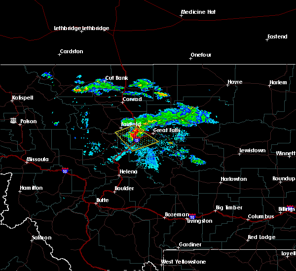 At 1021 pm mdt, a severe thunderstorm was located 8 miles northeast of cascade, moving southeast at 35 mph (radar indicated). Hazards include 60 mph wind gusts. Expect damage to roofs, siding, and trees. Locations impacted include, great falls, cascade, fort shaw, fort shaw, ulm, vaughn, first peoples buffalo jump state park, simms and sun river. At 1021 pm mdt, a severe thunderstorm was located 8 miles northeast of cascade, moving southeast at 35 mph (radar indicated). Hazards include 60 mph wind gusts. Expect damage to roofs, siding, and trees. Locations impacted include, great falls, cascade, fort shaw, fort shaw, ulm, vaughn, first peoples buffalo jump state park, simms and sun river.
|
| 7/25/2018 9:45 PM MDT |
 At 939 pm mdt, a severe thunderstorm was located near fairfield, or 16 miles southeast of choteau, moving southeast at 35 mph (radar indicated). Hazards include 60 mph wind gusts and quarter size hail. Hail damage to vehicles is expected. Expect wind damage to roofs, siding, and trees. At 939 pm mdt, a severe thunderstorm was located near fairfield, or 16 miles southeast of choteau, moving southeast at 35 mph (radar indicated). Hazards include 60 mph wind gusts and quarter size hail. Hail damage to vehicles is expected. Expect wind damage to roofs, siding, and trees.
|
| 6/25/2018 7:17 PM MDT |
 At 717 pm mdt, severe thunderstorms were located along a line extending from 11 miles north of black eagle to 9 miles west of belt, moving east at 45 mph (radar indicated). Hazards include 60 mph wind gusts and penny size hail. expect damage to roofs, siding, and trees At 717 pm mdt, severe thunderstorms were located along a line extending from 11 miles north of black eagle to 9 miles west of belt, moving east at 45 mph (radar indicated). Hazards include 60 mph wind gusts and penny size hail. expect damage to roofs, siding, and trees
|
| 6/4/2017 4:43 PM MDT | Quarter sized hail reported 11.7 miles WSW of Great Falls, MT, spotter reported quarter-size hail. |
| 6/4/2017 4:32 PM MDT | Spotter estimated 60 mph gust and penny-size hai in cascade county MT, 7.5 miles W of Great Falls, MT |
| 6/4/2017 4:18 PM MDT |
 At 417 pm mdt, a severe thunderstorm was located 10 miles southwest of belt, or 18 miles southeast of great falls, moving north at 30 mph. an additional thunderstorm just south of great falls is rapidly strengthening and may also become severe (radar indicated). Hazards include 60 mph wind gusts and half dollar size hail. Hail damage to vehicles is expected. Expect wind damage to roofs, siding, and trees. At 417 pm mdt, a severe thunderstorm was located 10 miles southwest of belt, or 18 miles southeast of great falls, moving north at 30 mph. an additional thunderstorm just south of great falls is rapidly strengthening and may also become severe (radar indicated). Hazards include 60 mph wind gusts and half dollar size hail. Hail damage to vehicles is expected. Expect wind damage to roofs, siding, and trees.
|
| 6/1/2017 5:40 PM MDT | Quarter sized hail reported 4.8 miles NNE of Great Falls, MT, quarter size hail reported in the big bend/fox farm area sw of great falls. |
| 6/1/2017 5:30 PM MDT | Rotted tree blown down by thunderstorm at corner of 13th ave sw and 14th st in great fall in cascade county MT, 0.3 miles N of Great Falls, MT |
| 6/1/2017 5:29 PM MDT |
 At 527 pm mdt, a severe thunderstorm was located near black eagle, or near great falls, moving northeast at 40 mph (60 to 70 mph winds have been observed along with very heavy rainfall and small hail). Hazards include 60 mph wind gusts and quarter size hail. Expect wind damage to roofs, siding, and trees. This severe thunderstorm will affect southwestern chouteau and northeastern cascade counties, including the following locations: shonkin, floweree, portage, ulm, malmstrom afb, sand coulee, stockett, tracy, carter and first peoples buffalo jump state park. At 527 pm mdt, a severe thunderstorm was located near black eagle, or near great falls, moving northeast at 40 mph (60 to 70 mph winds have been observed along with very heavy rainfall and small hail). Hazards include 60 mph wind gusts and quarter size hail. Expect wind damage to roofs, siding, and trees. This severe thunderstorm will affect southwestern chouteau and northeastern cascade counties, including the following locations: shonkin, floweree, portage, ulm, malmstrom afb, sand coulee, stockett, tracy, carter and first peoples buffalo jump state park.
|
| 6/1/2017 5:17 PM MDT |
 At 516 pm mdt, a severe thunderstorm was located near great falls, moving northeast at 35 mph (trained weather spotters have observed winds of 60 to 70 mph). Hazards include 60 mph wind gusts and quarter size hail. Hail damage to vehicles is expected. expect wind damage to roofs, siding, and trees. this severe storm will be near, great falls and black eagle around 525 pm mdt. Other locations impacted by this severe thunderstorm include portage, ulm, malmstrom afb, eden, sand coulee, stockett, tracy, vaughn, first peoples buffalo jump state park and centerville. At 516 pm mdt, a severe thunderstorm was located near great falls, moving northeast at 35 mph (trained weather spotters have observed winds of 60 to 70 mph). Hazards include 60 mph wind gusts and quarter size hail. Hail damage to vehicles is expected. expect wind damage to roofs, siding, and trees. this severe storm will be near, great falls and black eagle around 525 pm mdt. Other locations impacted by this severe thunderstorm include portage, ulm, malmstrom afb, eden, sand coulee, stockett, tracy, vaughn, first peoples buffalo jump state park and centerville.
|
| 6/1/2017 4:57 PM MDT |
 At 457 pm mdt, a severe thunderstorm was located 8 miles northeast of cascade, moving northeast at 35 mph (trained weather spotters have reported winds in excess of 60 mph near cascade). Hazards include 60 mph wind gusts and quarter size hail. Hail damage to vehicles is expected. expect wind damage to roofs, siding, and trees. this severe thunderstorm will be near, great falls and black eagle around 525 pm mdt. Other locations impacted by this severe thunderstorm include portage, ulm, malmstrom afb, eden, sand coulee, stockett, tracy, vaughn, first peoples buffalo jump state park and centerville. At 457 pm mdt, a severe thunderstorm was located 8 miles northeast of cascade, moving northeast at 35 mph (trained weather spotters have reported winds in excess of 60 mph near cascade). Hazards include 60 mph wind gusts and quarter size hail. Hail damage to vehicles is expected. expect wind damage to roofs, siding, and trees. this severe thunderstorm will be near, great falls and black eagle around 525 pm mdt. Other locations impacted by this severe thunderstorm include portage, ulm, malmstrom afb, eden, sand coulee, stockett, tracy, vaughn, first peoples buffalo jump state park and centerville.
|
| 5/6/2017 6:36 PM MDT |
 At 636 pm mdt, severe thunderstorms were located along a line extending from 11 miles east of highwood to 10 miles southeast of power, moving northeast at 30 mph (trained weather spotters reported gusts of 60 to 70 mph). Hazards include 60 mph wind gusts and penny size hail. Expect damage to roofs, siding, and trees. Locations impacted include, fort benton, the knees, highwood, power, carter, shonkin, floweree, portage and vaughn. At 636 pm mdt, severe thunderstorms were located along a line extending from 11 miles east of highwood to 10 miles southeast of power, moving northeast at 30 mph (trained weather spotters reported gusts of 60 to 70 mph). Hazards include 60 mph wind gusts and penny size hail. Expect damage to roofs, siding, and trees. Locations impacted include, fort benton, the knees, highwood, power, carter, shonkin, floweree, portage and vaughn.
|
| 5/6/2017 6:18 PM MDT | Quarter sized hail reported 1.9 miles SSE of Great Falls, MT, hail up to one inch in diameter and wind gusts estimated at 70 mph. |
| 5/6/2017 6:14 PM MDT |
 At 613 pm mdt, severe thunderstorms were located along a line extending from 8 miles northeast of belt to near fort shaw, moving northeast at 30 mph (radar and trained spotter indicated). Hazards include 60 mph wind gusts and quarter size hail. Hail damage to vehicles is expected. Expect wind damage to roofs, siding, and trees. At 613 pm mdt, severe thunderstorms were located along a line extending from 8 miles northeast of belt to near fort shaw, moving northeast at 30 mph (radar and trained spotter indicated). Hazards include 60 mph wind gusts and quarter size hail. Hail damage to vehicles is expected. Expect wind damage to roofs, siding, and trees.
|
| 5/6/2017 6:11 PM MDT | 64 mph thunderstorm wind gust at malmstrom af in cascade county MT, 5.2 miles W of Great Falls, MT |
| 5/6/2017 6:07 PM MDT | Storm damage reported in cascade county MT, 1.2 miles SSW of Great Falls, MT |
| 5/6/2017 6:05 PM MDT |
 At 604 pm mdt, severe thunderstorms were located along a line extending from 6 miles south of power to 6 miles southeast of highwood, moving northeast at 55 mph (trained weather spotters reported estimated wind gusts of 60 mph on the southwest end of great falls). Hazards include 60 mph wind gusts and half dollar size hail. Hail damage to vehicles is expected. expect wind damage to roofs, siding, and trees. Locations impacted include, great falls, belt, black eagle, fort shaw, highwood, fort shaw, power, carter, floweree, portage, malmstrom afb, tracy, vaughn, first peoples buffalo jump state park, sun river, shonkin, armington, ulm and sand coulee. At 604 pm mdt, severe thunderstorms were located along a line extending from 6 miles south of power to 6 miles southeast of highwood, moving northeast at 55 mph (trained weather spotters reported estimated wind gusts of 60 mph on the southwest end of great falls). Hazards include 60 mph wind gusts and half dollar size hail. Hail damage to vehicles is expected. expect wind damage to roofs, siding, and trees. Locations impacted include, great falls, belt, black eagle, fort shaw, highwood, fort shaw, power, carter, floweree, portage, malmstrom afb, tracy, vaughn, first peoples buffalo jump state park, sun river, shonkin, armington, ulm and sand coulee.
|
| 5/6/2017 6:01 PM MDT | Power went out at weather forecast office. currently running on backup power. wind and lightning in area at the tim in cascade county MT, 5.2 miles NE of Great Falls, MT |
| 5/6/2017 6:00 PM MDT | Quarter sized hail reported 17.6 miles NNE of Great Falls, MT, 1 inch diameter hail 8 mi ese of ulm around 6pm mdt. |
| 5/6/2017 5:58 PM MDT | Estimated 60 mph wind gust 5 miles south of great falls in fox far/big bend are in cascade county MT, 5.1 miles N of Great Falls, MT |
| 5/6/2017 5:44 PM MDT |
 At 544 pm mdt, severe thunderstorms were located along a line extending from 6 miles south of fort shaw to 7 miles south of belt, moving northeast at 55 mph (radar indicated). Hazards include 70 mph wind gusts and half dollar size hail. Hail damage to vehicles is expected. expect considerable tree damage. Wind damage is also likely to mobile homes, roofs, and outbuildings. At 544 pm mdt, severe thunderstorms were located along a line extending from 6 miles south of fort shaw to 7 miles south of belt, moving northeast at 55 mph (radar indicated). Hazards include 70 mph wind gusts and half dollar size hail. Hail damage to vehicles is expected. expect considerable tree damage. Wind damage is also likely to mobile homes, roofs, and outbuildings.
|
| 5/6/2017 5:24 PM MDT |
 At 524 pm mdt, a severe thunderstorm was located 11 miles southwest of great falls, moving northeast at 40 mph (radar indicated). Hazards include 60 mph wind gusts and half dollar size hail. Hail damage to vehicles is expected. expect wind damage to roofs, siding, and trees. Locations impacted include, great falls, cascade, black eagle, fort shaw, fort shaw, portage, malmstrom afb, eden, stockett, tracy, vaughn, first peoples buffalo jump state park, centerville, sun river, tower rock state park, craig, ulm and sand coulee. At 524 pm mdt, a severe thunderstorm was located 11 miles southwest of great falls, moving northeast at 40 mph (radar indicated). Hazards include 60 mph wind gusts and half dollar size hail. Hail damage to vehicles is expected. expect wind damage to roofs, siding, and trees. Locations impacted include, great falls, cascade, black eagle, fort shaw, fort shaw, portage, malmstrom afb, eden, stockett, tracy, vaughn, first peoples buffalo jump state park, centerville, sun river, tower rock state park, craig, ulm and sand coulee.
|
| 5/6/2017 5:14 PM MDT |
 At 513 pm mdt, a severe thunderstorm was located near cascade, moving northeast at 60 mph (radar indicated). Hazards include 60 mph wind gusts and half dollar size hail. Hail damage to vehicles is expected. expect wind damage to roofs, siding, and trees. Locations impacted include, great falls, cascade, black eagle, fort shaw, fort shaw, portage, malmstrom afb, eden, stockett, tracy, vaughn, first peoples buffalo jump state park, centerville, sun river, tower rock state park, craig, ulm and sand coulee. At 513 pm mdt, a severe thunderstorm was located near cascade, moving northeast at 60 mph (radar indicated). Hazards include 60 mph wind gusts and half dollar size hail. Hail damage to vehicles is expected. expect wind damage to roofs, siding, and trees. Locations impacted include, great falls, cascade, black eagle, fort shaw, fort shaw, portage, malmstrom afb, eden, stockett, tracy, vaughn, first peoples buffalo jump state park, centerville, sun river, tower rock state park, craig, ulm and sand coulee.
|
| 5/6/2017 4:59 PM MDT |
 At 458 pm mdt, a severe thunderstorm was located 13 miles east of wolf creek, or 14 miles south of cascade, moving northeast at 60 mph (radar indicated along). Hazards include 60 mph wind gusts and penny size hail. expect damage to roofs, siding, and trees At 458 pm mdt, a severe thunderstorm was located 13 miles east of wolf creek, or 14 miles south of cascade, moving northeast at 60 mph (radar indicated along). Hazards include 60 mph wind gusts and penny size hail. expect damage to roofs, siding, and trees
|
| 9/1/2016 4:40 PM MDT | 2 trees blown down and one power line blown down on the east side of great fall in cascade county MT, 4.7 miles W of Great Falls, MT |
| 9/1/2016 4:39 PM MDT | 64 mph wind gust at malmstrom air force bas in cascade county MT, 5.2 miles W of Great Falls, MT |
| 8/18/2016 1:50 AM MDT | Quarter sized hail reported 12.5 miles WNW of Great Falls, MT, nickel to quarter-size hail covering road along mt 200. |
| 8/18/2016 1:46 AM MDT | Quarter sized hail reported 9.4 miles WNW of Great Falls, MT, hail up to quarter size falling. |
| 8/18/2016 1:23 AM MDT |
 The severe thunderstorm warning for northeastern cascade county will expire at 130 am mdt, the storm which prompted the warning has weakened below severe limits, and no longer poses an immediate threat to life or property. therefore, the warning will be allowed to expire. however small hail is still possible with this thunderstorm. The severe thunderstorm warning for northeastern cascade county will expire at 130 am mdt, the storm which prompted the warning has weakened below severe limits, and no longer poses an immediate threat to life or property. therefore, the warning will be allowed to expire. however small hail is still possible with this thunderstorm.
|
| 8/18/2016 1:12 AM MDT |
 At 110 am mdt, a severe thunderstorm was located 7 miles southeast of great falls, moving east at 10 mph (radar indicated. at 12:45 am, half dollar size hail was reported by an nws employee in great falls. radar indicates this storm is capable of hail up to ping pong ball-size). Hazards include ping pong ball size hail. People and animals outdoors will be injured. expect damage to roofs, siding, windows, and vehicles. Locations impacted include, great falls, black eagle and malmstrom afb. At 110 am mdt, a severe thunderstorm was located 7 miles southeast of great falls, moving east at 10 mph (radar indicated. at 12:45 am, half dollar size hail was reported by an nws employee in great falls. radar indicates this storm is capable of hail up to ping pong ball-size). Hazards include ping pong ball size hail. People and animals outdoors will be injured. expect damage to roofs, siding, windows, and vehicles. Locations impacted include, great falls, black eagle and malmstrom afb.
|
| 8/18/2016 12:50 AM MDT | Half Dollar sized hail reported 0.3 miles N of Great Falls, MT, hail falling up to 1.25 inch. |
| 8/18/2016 12:46 AM MDT | Quarter sized hail reported 9.4 miles WNW of Great Falls, MT, hail up to quarter size falling. |
| 8/18/2016 12:45 AM MDT | Half Dollar sized hail reported 0.3 miles N of Great Falls, MT, half dollar-size hail. |
| 8/18/2016 12:45 AM MDT |
 At 1243 am mdt, a severe thunderstorm was located near great falls, moving southeast at 20 mph (trained weather spotters). Hazards include ping pong ball size hail. People and animals outdoors will be injured. expect damage to roofs, siding, windows, and vehicles. locations impacted include, great falls, black eagle, stockett, malmstrom afb, tracy, centerville and sand coulee. Numerous reports of hail up to ping pong size hail falling across much of the city of great falls. At 1243 am mdt, a severe thunderstorm was located near great falls, moving southeast at 20 mph (trained weather spotters). Hazards include ping pong ball size hail. People and animals outdoors will be injured. expect damage to roofs, siding, windows, and vehicles. locations impacted include, great falls, black eagle, stockett, malmstrom afb, tracy, centerville and sand coulee. Numerous reports of hail up to ping pong size hail falling across much of the city of great falls.
|
| 8/18/2016 12:40 AM MDT | Half Dollar sized hail reported 0.3 miles N of Great Falls, MT, half dollar size hail falling. |
| 8/18/2016 12:34 AM MDT | Half Dollar sized hail reported 0.3 miles N of Great Falls, MT, hail a bit bigger than quarters falling in great falls. |
| 8/18/2016 12:33 AM MDT | Quarter sized hail reported 0.3 miles N of Great Falls, MT, nickel to quarter-size hail. |
| 8/18/2016 12:33 AM MDT |
 At 1233 am mdt, a severe thunderstorm was located over black eagle, or over great falls, moving southeast at 20 mph (trained weather spotters). Hazards include ping pong ball size hail. People and animals outdoors will be injured. Expect damage to roofs, siding, windows, and vehicles. At 1233 am mdt, a severe thunderstorm was located over black eagle, or over great falls, moving southeast at 20 mph (trained weather spotters). Hazards include ping pong ball size hail. People and animals outdoors will be injured. Expect damage to roofs, siding, windows, and vehicles.
|
| 8/18/2016 12:32 AM MDT | Ping Pong Ball sized hail reported 0.3 miles N of Great Falls, MT, ping pong size hail falling in great fallls. |
| 8/10/2016 12:28 AM MDT | Quarter sized hail reported 0.3 miles N of Great Falls, MT, location near benefis east |
| 8/10/2016 12:08 AM MDT | Quarter sized hail reported 1.9 miles W of Great Falls, MT, dime to quarter sized hail reported in great falls. |
| 8/10/2016 12:08 AM MDT |
 At 1208 am mdt, severe thunderstorms were located along a line extending from 8 miles southeast of power to 9 miles east of black eagle, moving northeast at 35 mph (trained weather spotters). Hazards include 60 mph wind gusts and quarter size hail. Hail damage to vehicles is expected. Expect wind damage to roofs, siding, and trees. At 1208 am mdt, severe thunderstorms were located along a line extending from 8 miles southeast of power to 9 miles east of black eagle, moving northeast at 35 mph (trained weather spotters). Hazards include 60 mph wind gusts and quarter size hail. Hail damage to vehicles is expected. Expect wind damage to roofs, siding, and trees.
|
| 8/10/2016 12:05 AM MDT | Quarter sized hail reported 1 miles WNW of Great Falls, MT, some quarter sized hail...but lots of pea to nickel sized hail. |
| 8/9/2016 11:55 PM MDT | Quarter sized hail reported 5.1 miles N of Great Falls, MT, quarter sized hail reported just south of great falls. |
| 8/9/2016 6:54 PM MDT |
 The severe thunderstorm warning for southwestern chouteau and northeastern cascade counties will expire at 700 pm mdt, the storm which prompted the warning has weakened below severe limits, and no longer pose an immediate threat to life or property. therefore, the warning will be allowed to expire. however gusty winds are still possible with this thunderstorm. a severe thunderstorm watch remains in effect until midnight mdt for north central and central montana. The severe thunderstorm warning for southwestern chouteau and northeastern cascade counties will expire at 700 pm mdt, the storm which prompted the warning has weakened below severe limits, and no longer pose an immediate threat to life or property. therefore, the warning will be allowed to expire. however gusty winds are still possible with this thunderstorm. a severe thunderstorm watch remains in effect until midnight mdt for north central and central montana.
|
| 8/9/2016 6:22 PM MDT |
 At 621 pm mdt, a severe thunderstorm was located near black eagle, or near great falls, moving east at 20 mph (malmstrom air force base reported a 58 mph wind gust at 619 pm mdt). Hazards include 60 mph wind gusts and quarter size hail. Hail damage to vehicles is expected. Expect wind damage to roofs, siding, and trees. At 621 pm mdt, a severe thunderstorm was located near black eagle, or near great falls, moving east at 20 mph (malmstrom air force base reported a 58 mph wind gust at 619 pm mdt). Hazards include 60 mph wind gusts and quarter size hail. Hail damage to vehicles is expected. Expect wind damage to roofs, siding, and trees.
|
| 8/9/2016 6:10 PM MDT | Storm damage reported in cascade county MT, 5.2 miles W of Great Falls, MT |
| 6/11/2016 5:11 AM MDT |
 The severe thunderstorm warning for southwestern chouteau and north central cascade counties will expire at 515 am mdt, the storm which prompted the warning has moved out of the area. therefore the warning will be allowed to expire. hail is still possible with this thunderstorm. The severe thunderstorm warning for southwestern chouteau and north central cascade counties will expire at 515 am mdt, the storm which prompted the warning has moved out of the area. therefore the warning will be allowed to expire. hail is still possible with this thunderstorm.
|
| 6/11/2016 5:06 AM MDT |
 At 505 am mdt, a severe thunderstorm was located 12 miles northeast of black eagle, or 13 miles northeast of great falls, moving northeast at 55 mph (radar indicated). Hazards include ping pong ball size hail was reported in great falls. People and animals outdoors will be injured. expect damage to roofs, siding, windows, and vehicles. Locations impacted include, great falls, black eagle, carter, portage, floweree and malmstrom afb. At 505 am mdt, a severe thunderstorm was located 12 miles northeast of black eagle, or 13 miles northeast of great falls, moving northeast at 55 mph (radar indicated). Hazards include ping pong ball size hail was reported in great falls. People and animals outdoors will be injured. expect damage to roofs, siding, windows, and vehicles. Locations impacted include, great falls, black eagle, carter, portage, floweree and malmstrom afb.
|
| 6/11/2016 5:00 AM MDT | Golf Ball sized hail reported 2.8 miles W of Great Falls, MT, golf ball size hail reported on the east side of great falls. hail caused damage to vehicles |
| 6/11/2016 4:55 AM MDT | Ping Pong Ball sized hail reported 0.3 miles N of Great Falls, MT |
| 6/11/2016 4:55 AM MDT | Half Dollar sized hail reported 0.3 miles N of Great Falls, MT |
| 6/11/2016 4:52 AM MDT | Quarter sized hail reported 0.3 miles N of Great Falls, MT |
| 6/11/2016 4:50 AM MDT | Quarter sized hail reported 5.2 miles NE of Great Falls, MT, quarter size hail fell at the wfo great falls office |
| 6/11/2016 4:50 AM MDT |
 At 449 am mdt, a severe thunderstorm was located over great falls, moving northeast at 55 mph (radar indicated). Hazards include quarter size hail observed at nws office. damage to vehicles is expected At 449 am mdt, a severe thunderstorm was located over great falls, moving northeast at 55 mph (radar indicated). Hazards include quarter size hail observed at nws office. damage to vehicles is expected
|
| 6/8/2016 7:21 PM MDT |
 The severe thunderstorm warning for central cascade county will expire at 730 pm mdt, the storm which prompted the warning has weakened below severe limits, and no longer pose an immediate threat to life or property. therefore the warning will be allowed to expire. however gusty winds around 40 mph are still possible with this thunderstorm. The severe thunderstorm warning for central cascade county will expire at 730 pm mdt, the storm which prompted the warning has weakened below severe limits, and no longer pose an immediate threat to life or property. therefore the warning will be allowed to expire. however gusty winds around 40 mph are still possible with this thunderstorm.
|
| 6/8/2016 6:53 PM MDT |
 At 653 pm mdt, a severe thunderstorm was located 10 miles southwest of great falls, moving east at 35 mph (radar indicated). Hazards include 70 mph wind gusts. Expect considerable tree damage. damage is likely to mobile homes, roofs, and outbuildings. Locations impacted include, great falls, cascade, fort shaw, fort shaw, black eagle, sand coulee, first peoples buffalo jump state park, tracy, sluice boxes state park, vaughn, stockett, centerville, sun river, ulm, eden and malmstrom afb. At 653 pm mdt, a severe thunderstorm was located 10 miles southwest of great falls, moving east at 35 mph (radar indicated). Hazards include 70 mph wind gusts. Expect considerable tree damage. damage is likely to mobile homes, roofs, and outbuildings. Locations impacted include, great falls, cascade, fort shaw, fort shaw, black eagle, sand coulee, first peoples buffalo jump state park, tracy, sluice boxes state park, vaughn, stockett, centerville, sun river, ulm, eden and malmstrom afb.
|
| 6/8/2016 6:43 PM MDT |
 At 642 pm mdt, a severe thunderstorm was located 8 miles southeast of fort shaw, or 8 miles north of cascade, moving northeast at 15 mph (radar indicated). Hazards include 60 mph wind gusts. Expect damage to roofs. siding. And trees. At 642 pm mdt, a severe thunderstorm was located 8 miles southeast of fort shaw, or 8 miles north of cascade, moving northeast at 15 mph (radar indicated). Hazards include 60 mph wind gusts. Expect damage to roofs. siding. And trees.
|
| 8/29/2015 5:15 PM MDT | Storm damage reported in cascade county MT, 4.8 miles ENE of Great Falls, MT |
| 8/14/2015 6:57 PM MDT | 66 mph wind gust about 6 miles northeast of great falls in cascade county MT, 6.4 miles SSW of Great Falls, MT |
| 8/14/2015 6:50 PM MDT | Estimated gusts up to 60 mph rocking car in cascade county MT, 5.2 miles S of Great Falls, MT |
| 5/31/2014 7:25 AM MDT | Quarter sized hail reported 11.9 miles NNE of Great Falls, MT, hail cracked plastic vent on top of a trailer |
| 5/28/2014 5:10 PM MDT | Quarter sized hail reported 0.3 miles N of Great Falls, MT |
| 5/15/2014 8:05 PM MDT | Quarter sized hail reported 20.2 miles NNE of Great Falls, MT, qaurter sized hail and heavy rain. wind gusts estimated to 40 mph. |
| 5/4/2014 4:00 PM MDT | Quarter sized hail reported 6.2 miles SW of Great Falls, MT, quarter sized hail reported on u.s. highway 87 6 miles northeast of great falls. |
| 5/4/2014 4:00 PM MDT | Quarter sized hail reported 6.1 miles W of Great Falls, MT, quarter sized hail reported on u.s. highway 89 6 miles east of great falls. |
| 5/4/2014 3:40 PM MDT | Quarter sized hail reported 0.3 miles N of Great Falls, MT |
| 5/4/2014 3:38 PM MDT | Quarter sized hail reported 2.3 miles SE of Great Falls, MT |
| 5/4/2014 3:37 PM MDT | Quarter sized hail reported 2.2 miles WSW of Great Falls, MT |
| 5/4/2014 3:20 PM MDT | Golf Ball sized hail reported 9.2 miles ESE of Great Falls, MT |
| 9/5/2013 4:13 PM MDT | 62 mph convective wind gust at the great falls airpor in cascade county MT, 4.8 miles ENE of Great Falls, MT |
| 9/5/2013 4:13 PM MDT | Tree damage from thunderstorm outflow boundary winds....tree was snapped in half and was estimated to be 8 to 10 inches in diameter in cascade county MT, 6.1 miles NE of Great Falls, MT |
| 7/24/2013 8:55 PM MDT | Quarter sized hail reported 5.2 miles S of Great Falls, MT, multiple social media photos posts of quarter sized hail or larger along bootlegger trail. location and time estimated from radar. |
| 7/24/2013 8:55 AM MDT | Quarter sized hail reported 5.2 miles S of Great Falls, MT, multiple social media photos posts of quarter sized hail or larger along bootlegger trail. location and time estimated from radar. |
| 7/8/2013 6:50 PM MDT | Storm damage reported in cascade county MT, 0.3 miles N of Great Falls, MT |
| 7/8/2013 6:45 PM MDT | Thunderstorm outflow winds...thunderstorms to the northwest...some blowing dus in cascade county MT, 5.2 miles NE of Great Falls, MT |
| 6/19/2013 6:00 PM MDT | Storm damage reported in cascade county MT, 0.3 miles N of Great Falls, MT |
| 8/21/2012 6:00 PM MDT | Tree down on power line near corner of central avenue west and i-15...downed light pole on central avenue bridge...power outages on northwest side of great falls in cascade county MT, 0.3 miles N of Great Falls, MT |
| 8/14/2012 8:53 PM MDT | 62 mph wind gust just north of black eagl in cascade county MT, 1.8 miles S of Great Falls, MT |
| 8/14/2012 8:45 PM MDT | 3 inch tree limb broken off...and no powe in cascade county MT, 1.1 miles NNW of Great Falls, MT |
| 8/14/2012 8:28 PM MDT | 62 mph wind gust at the nws office. power was out for a few minutes. blowing dus in cascade county MT, 5.2 miles NE of Great Falls, MT |
| 8/14/2012 8:23 PM MDT | 60 mph wind gust. power out at the nws office in great falls. visibility is 2 miles in blowing dus in cascade county MT, 4.8 miles ENE of Great Falls, MT |
| 7/30/2012 4:50 PM MDT | Damaged roof in cascade county MT, 0.3 miles N of Great Falls, MT |
| 7/30/2012 4:41 PM MDT | Badly damaged billboard along the interstate in cascade county MT, 4.8 miles ENE of Great Falls, MT |
| 7/30/2012 4:41 PM MDT | Badly damaged a billboard along the interstate in cascade county MT, 4.8 miles ENE of Great Falls, MT |
| 7/6/2012 5:42 PM MDT | Power pole snapped and power lines dow in cascade county MT, 2.4 miles N of Great Falls, MT |
| 7/6/2012 5:37 PM MDT | 63 mph wind measured at great falls nws office. very heavy rai in cascade county MT, 5.2 miles NE of Great Falls, MT |
| 6/26/2012 1:10 PM MDT | Quarter sized hail reported 12.2 miles S of Great Falls, MT |
| 6/4/2012 7:17 PM MDT | Quarter sized hail reported 9.2 miles ESE of Great Falls, MT, estimated 1 inch hail in sun prairie |
| 1/1/0001 12:00 AM | Strong thunderstorm winds blew the roof of a vacant mobile home off on the south side of great falls and debris was thrown close to nearby power lines. fire department in cascade county MT, 0.3 miles N of Great Falls, MT |
| 1/1/0001 12:00 AM | Tree 8 inches in diameter snapped off half way up the trunk south of great falls near the rive in cascade county MT, 0.3 miles N of Great Falls, MT |
| 1/1/0001 12:00 AM | Wind has torn 2-3 inch diameter branches off of trees. construction materials on warden bridge blew into traffic lanes and are blocking traffi in cascade county MT, 0.3 miles N of Great Falls, MT |
| 1/1/0001 12:00 AM | Power pole snapped near 11th ave and 29th st. 4 to 6 inch diameter tree snappe in cascade county MT, 1.7 miles NW of Great Falls, MT |
| 1/1/0001 12:00 AM | A metal roof was blown off a trailer or shed in the northern portion of great falls. the roof made contact with a power line and witnesses reported that it triggered so in cascade county MT, 0.3 miles N of Great Falls, MT |
| 1/1/0001 12:00 AM | Ping Pong Ball sized hail reported 3.7 miles W of Great Falls, MT |
| 1/1/0001 12:00 AM | Ping Pong Ball sized hail reported 8 miles W of Great Falls, MT |
Hail Maps for Great Falls, MT
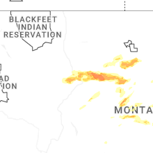


Connect with Interactive Hail Maps