

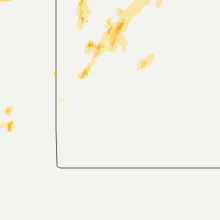
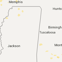
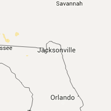
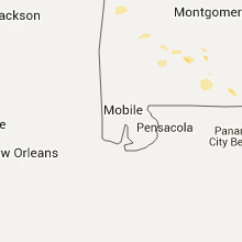
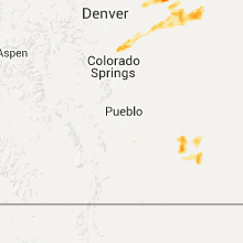
Hail Map for Friday, August 7, 2015

Number of Impacted Households on 8/7/2015
0
Impacted by 1" or Larger Hail
0
Impacted by 1.75" or Larger Hail
0
Impacted by 2.5" or Larger Hail
Square Miles of Populated Area Impacted on 8/7/2015
0
Impacted by 1" or Larger Hail
0
Impacted by 1.75" or Larger Hail
0
Impacted by 2.5" or Larger Hail


Cities Most Affected by Hail Storms of 8/7/2015
| Hail Size | Demographics of Zip Codes Affected | ||||||
|---|---|---|---|---|---|---|---|
| City | Count | Average | Largest | Pop Density | House Value | Income | Age |
| Tower City, ND | 2 | 2.13 | 2.50 | 3 | $55k | $37.0k | 41.8 |
| Wiggins, CO | 1 | 3.00 | 3.00 | 10 | $108k | $36.4k | 37.5 |
| Elizabeth, CO | 1 | 2.00 | 2.00 | 66 | $220k | $67.6k | 43.1 |
| Weldona, CO | 1 | 1.75 | 1.75 | 6 | $79k | $35.8k | 45.5 |
| Stratton, NE | 1 | 1.75 | 1.75 | 1 | $38k | $26.1k | 50.9 |
| Franktown, CO | 1 | 1.75 | 1.75 | 43 | $389k | $82.6k | 50.5 |
| Buffalo, ND | 1 | 1.75 | 1.75 | 2 | $70k | $36.8k | 46.4 |
| Champion, NE | 1 | 1.75 | 1.75 | 2 | $35k | $30.3k | 45.6 |
Hail and Wind Damage Spotted on 8/7/2015
Filter by Report Type:Hail ReportsWind Reports
States Impacted
Arkansas, Mississippi, Alabama, Florida, Georgia, Arizona, Nevada, Colorado, North Dakota, Utah, New Mexico, Kansas, Minnesota, NebraskaArkansas
| Local Time | Report Details |
|---|---|
| 8:13 AM CDT | Tree down west of wynne on hwy 64 near hwy 93 in cross county AR, 45.1 miles W of Memphis, TN |
Mississippi
| Local Time | Report Details |
|---|---|
| 9:39 AM CDT | Spotter reports 2 large trees uprooted. measured 61 mph gust via anemometer in lafayette county MS, 60.1 miles SSE of Memphis, TN |
| 9:53 AM CDT | Trees downed on powerlines caused several power outages in oxford in lafayette county MS, 61.9 miles SSE of Memphis, TN |
| 9:55 AM CDT | Emergency manager of oxford reports several trees down across city roads...cleanup in progres in lafayette county MS, 61.9 miles SSE of Memphis, TN |
| 9:55 AM CDT | Oxford em reports several trees down across city roads...cleanup in progres in lafayette county MS, 61.9 miles SSE of Memphis, TN |
| 9:58 AM CDT | Tree down on old tayor road at the mark apartments in lafayette county MS, 61.9 miles SSE of Memphis, TN |
Alabama
| Local Time | Report Details |
|---|---|
| 12:49 PM CDT | A few trees were blwon down along highway 28 northwest of livingston. one tree was blocking the roadwa in sumter county AL, 68 miles SSE of Starkville, MS |
| 1:12 PM CDT | A few trees were blown down along highway 28 at coatop in sumter county AL, 57.1 miles NW of Camden, AL |
| 2:33 PM CDT | Tree down at county road 67 and county rd 33 in dale county AL, 72.3 miles S of Auburn, AL |
| 2:33 PM CDT | Trees down on east county rd 3 in dale county AL, 78.4 miles S of Auburn, AL |
| 2:40 PM CDT | Tree down along county road 315 in coffee county AL, 76 miles SSW of Auburn, AL |
| 4:23 PM CDT | Trees down near county roads 625 and 655 in coffee county AL, 62.3 miles NNE of Miramar Beach, FL |
| 4:30 PM CDT | Power line down in samson in geneva county AL, 53.9 miles NNE of Miramar Beach, FL |
Florida
| Local Time | Report Details |
|---|---|
| 2:00 PM EDT | Large tree down at 8100 w coralberry lane in duval county FL, 11 miles SW of Jacksonville, FL |
| 2:00 PM EDT | Tree down on collins road between blanding blvd and roosevelt blvd in duval county FL, 12 miles SW of Jacksonville, FL |
| 3:00 PM EDT | A large tree was toppled by strong thunderstorm winds near the intersection of county roads 13 and 208. time of damage based on radar dat in st. johns county FL, 29.3 miles S of Jacksonville, FL |
| 3:03 PM EDT | Tree down at cr 108 and 2 miles west of hwy 1 in nassau county FL, 29.6 miles NNW of Jacksonville, FL |
| 3:10 PM EDT | St. johns county 911/dispatch reports a powerline downed by thunderstorm wind gusts along greenbrier road. time of damage based on radar dat in st. johns county FL, 19.8 miles SSE of Jacksonville, FL |
| 4:15 PM EDT | Numerous large trees down across hwy 41 in hamilton county FL, 64.4 miles S of Douglas, GA |
| 4:30 PM EDT | Trees down near genoa along hwy 41. time estimated based on radar in hamilton county FL, 70.9 miles W of Jacksonville, FL |
| 4:45 PM EDT | Trees down near genoa along hwy 41. time estimated based on radar in hamilton county FL, 70.3 miles W of Jacksonville, FL |
| 4:50 PM EDT | Tree down just n of white springs. time estimated based on rada in hamilton county FL, 66 miles W of Jacksonville, FL |
| 5:15 PM EDT | Large limbs blown down at savannah circle and colquitt way. the time of damage was based on rada in columbia county FL, 63.8 miles W of Jacksonville, FL |
| 5:22 PM EDT | Trees were blown down along country club hammock road near county road 25 in columbia county FL, 58.2 miles WSW of Jacksonville, FL |
| 5:55 PM EDT | Trees were blown down along sw 73rd way. the time of damage was based on rada in union county FL, 48.1 miles WSW of Jacksonville, FL |
| 5:55 PM EDT | Trees were blown down along sw 73ed way. the time of damage was based on rada in union county FL, 48.1 miles WSW of Jacksonville, FL |
| 5:55 PM EDT | A tree was blown down along sw 144th avenue. the time of damage was based on rada in bradford county FL, 46.2 miles SW of Jacksonville, FL |
| 6:05 PM EDT | Trees down in the westbound lane of i-10 in gadsden county FL, 36.4 miles WNW of Tallahassee, FL |
| 5:08 PM CDT | Tree and powerline down in douglass crossroad in walton county FL, 31.4 miles NE of Miramar Beach, FL |
| 6:10 PM EDT | Trees down in the western part of gadsden county in gadsden county FL, 19.5 miles WNW of Tallahassee, FL |
| 6:30 PM EDT | Trees were blown down along ne 80th and ne 24th loo in gilchrist county FL, 72.2 miles WSW of Jacksonville, FL |
| 6:45 PM EDT | Trees were blown across state road 26 near the gilchrist and alachua county lin in gilchrist county FL, 80.5 miles SW of Jacksonville, FL |
| 6:45 PM EDT | Tree down on wakulla springs rd north of highway 26 in wakulla county FL, 13.2 miles S of Tallahassee, FL |
| 6:45 PM EDT | Fhp reports tree in the road at natural bridge road and woodville highway in leon county FL, 9.1 miles SSE of Tallahassee, FL |
| 6:55 PM EDT | Trees down along sw 100th stree in gilchrist county FL, 87 miles SW of Jacksonville, FL |
| 7:00 PM EDT | Large tree down near natural bridge road and old plank road in leon county FL, 12.9 miles SE of Tallahassee, FL |
| 7:12 PM EDT | Tree down on croatan stree in wakulla county FL, 18.7 miles S of Tallahassee, FL |
| 7:19 PM EDT | Tree down along avalon road in jefferson county FL, 23.4 miles ESE of Tallahassee, FL |
| 7:30 PM EDT | Tree down on hardee road in wakulla county FL, 28.3 miles SSW of Tallahassee, FL |
| 8:20 PM EDT | Tree down on turlington lane in lafayette county FL, 61.1 miles ESE of Tallahassee, FL |
| 8:42 PM EDT | Tree down on county road 412 in lafayette county FL, 78.3 miles ESE of Tallahassee, FL |
Georgia
| Local Time | Report Details |
|---|---|
| 3:15 PM EDT | Trees down near morven in brooks county GA, 54.8 miles SW of Douglas, GA |
| 3:15 PM EDT | Trees down along jackson road in brooks county GA, 54.3 miles NE of Tallahassee, FL |
| 3:30 PM EDT | Large tree on house on gornto r in lowndes county GA, 52.5 miles SSW of Douglas, GA |
| 3:34 PM EDT | 60 reports of trees and powerlines down in valdosta and southern lowndes count in lowndes county GA, 51.9 miles SSW of Douglas, GA |
| 3:39 PM EDT | One residence had 6 to 7 trees blown down and many shingles blown off roo in lowndes county GA, 50.8 miles SSW of Douglas, GA |
| 5:08 PM EDT | Shed destoryed near highway 285 east of highway 3 in seminole county GA, 50.2 miles NW of Tallahassee, FL |
| 6:42 PM EDT | Trees down near coolidge in thomas county GA, 46.3 miles NNE of Tallahassee, FL |
| 6:45 PM EDT | Trees down near pavo in brooks county GA, 48.2 miles NE of Tallahassee, FL |
| 6:45 PM EDT | Trees down near quitman in brooks county GA, 49.2 miles ENE of Tallahassee, FL |
| 6:50 PM EDT | Trees down near highway 122 and 76 in brooks county GA, 52.3 miles SW of Douglas, GA |
| 6:50 PM EDT | Trees down on union church road in brooks county GA, 46.9 miles ENE of Tallahassee, FL |
| 6:50 PM EDT | Trees down on old madison road in brooks county GA, 49.5 miles ENE of Tallahassee, FL |
Arizona
| Local Time | Report Details |
|---|---|
| 1:00 PM MST | Power pole down near lambert and camino de oeste in pima county AZ, 13.4 miles NNW of Tucson, AZ |
| 1:14 PM MST | 60 mph wind gust reported at san carlos mesonet site in graham county AZ, 69.6 miles SSW of Show Low, AZ |
| 1:30 PM MST | Live wire blown down in residential area. water covering roadway. flooding in residential area in gila county AZ, 66.3 miles SSW of Show Low, AZ |
| 3:00 PM MST | Roof blown off house and 2.5 ft. diameter tree blown dow in pinal county AZ, 44.8 miles SE of Phoenix, AZ |
| 3:00 PM MST | 3 in. diameter tree branches blown of in pinal county AZ, 44.2 miles SE of Phoenix, AZ |
| 3:40 PM MST | Local online newspaper media and fire department reported multiple thunderstorm wind damages including a roof blown off a house... a power line snapped on 9th st. and v in pinal county AZ, 45.2 miles SE of Phoenix, AZ |
| 3:44 PM MST | 8 in. diameter tree blown dow in pinal county AZ, 45.2 miles SE of Phoenix, AZ |
| 4:27 PM MST | Storm damage reported in maricopa county AZ, 19.7 miles SE of Phoenix, AZ |
| 4:30 PM MST | Several large trees down gilbert to val vista rd in s gilbert - time estimated in maricopa county AZ, 20.3 miles ESE of Phoenix, AZ |
Nevada
| Local Time | Report Details |
|---|---|
| 1:50 PM PDT | Tonopah airport measured peak wind of 50 knots. likely outflow from nearby thunderstorms to the west in nye county NV, 144.2 miles SW of Ely, NV |
Colorado
| Local Time | Report Details |
|---|---|
| 3:07 PM MDT | Storm damage reported in bent county CO, 80 miles ESE of Pueblo, CO |
| 3:07 PM MDT | Half Dollar sized hail reported near Las Animas, CO, 80 miles ESE of Pueblo, CO |
| 3:15 PM MDT | Golf Ball sized hail reported near Weldona, CO, 65.9 miles NE of Denver, CO |
| 3:30 PM MDT | Quarter sized hail reported near Weldona, CO, 65.9 miles NE of Denver, CO |
| 3:45 PM MDT | Tea Cup sized hail reported near Wiggins, CO, 63.2 miles NE of Denver, CO, actual measurement was 3.5 inches in diameter |
| 3:53 PM MDT | Quarter sized hail reported near La Junta, CO, 64.2 miles ESE of Pueblo, CO |
| 3:53 PM MDT | Quarter sized hail reported near Weldona, CO, 68.2 miles NE of Denver, CO |
| 4:03 PM MDT | Golf Ball sized hail reported near Franktown, CO, 28.2 miles SSE of Denver, CO |
| 4:12 PM MDT | Quarter sized hail reported near Elizabeth, CO, 30.4 miles SE of Denver, CO |
| 4:17 PM MDT | Ping Pong Ball sized hail reported near Elizabeth, CO, 30.8 miles SE of Denver, CO |
| 4:33 PM MDT | Half Dollar sized hail reported near Weldona, CO, 64.8 miles WNW of Yuma, CO |
| 4:35 PM MDT | Hen Egg sized hail reported near Elizabeth, CO, 30.6 miles SE of Denver, CO, 2.25 diameter hail |
| 5:42 PM MDT | Half Dollar sized hail reported near Fort Morgan, CO, 57.8 miles W of Yuma, CO |
| 6:01 PM MDT | Quarter sized hail reported near Brush, CO, 49.9 miles W of Yuma, CO |
North Dakota
| Local Time | Report Details |
|---|---|
| 4:45 PM CDT | Quarter sized hail reported near Ashley, ND, 43.2 miles NW of Aberdeen, SD, hail started at 445 pm and lasted to 450 pm. most hail was pea sized with a few quarter sized. |
| 5:45 PM CDT | Half Dollar sized hail reported near Litchville, ND, 66.8 miles WSW of Fargo, ND |
| 5:48 PM CDT | Quarter sized hail reported near Ellendale, ND, 44.3 miles N of Aberdeen, SD |
| 5:59 PM CDT | Ping Pong Ball sized hail reported near Valley City, ND, 54.3 miles W of Fargo, ND, report and picture posted to social media. time estimated based on radar. |
| 6:08 PM CDT | Ping Pong Ball sized hail reported near Page, ND, 40.4 miles WNW of Fargo, ND, report and picture posted to social media. |
| 6:10 PM CDT | Golf Ball sized hail reported near Tower City, ND, 43 miles W of Fargo, ND, report and picture posted to social media. time estimated based on radar. |
| 6:10 PM CDT | Tennis Ball sized hail reported near Tower City, ND, 43 miles W of Fargo, ND, report and picture posted to social media. time estimated based on radar. |
| 6:15 PM CDT | Half Dollar sized hail reported near Fort Ransom, ND, 58.1 miles WSW of Fargo, ND, quarter to half dollar sized hail occurrerd for 2 to 3 minutes. report and picture posted to social media. |
| 6:20 PM CDT | Golf Ball sized hail reported near Buffalo, ND, 36.5 miles W of Fargo, ND, report and picture posted to social media. time estimated based on radar. |
| 6:35 PM CDT | Measured 1.25 inches of rain and dime sized hail. reported by nd arb observer in cass county ND, 27.4 miles NW of Fargo, ND |
| 7:05 PM CDT | Quarter sized hail reported near Argusville, ND, 15.2 miles NW of Fargo, ND |
| 8:10 PM CDT | Quarter sized hail reported near Gardner, ND, 19.1 miles NNW of Fargo, ND, a few dime to quarter sized hail and brief heavy rains. |
Utah
| Local Time | Report Details |
|---|---|
| 4:20 PM MDT | Wendover awos in tooele county UT, 91 miles E of Elko, NV |
| 4:40 PM MDT | North salt flats sensor dpg25 in tooele county UT, 99.3 miles W of Salt Lake City, UT |
| 4:45 PM MDT | West salt flats sensor dpg26 in tooele county UT, 95.5 miles NE of Ely, NV |
| 4:45 PM MDT | North salt flats sensor dpg25 in tooele county UT, 99.3 miles W of Salt Lake City, UT |
| 4:55 PM MDT | West salt flats sensor dpg26 in tooele county UT, 95.5 miles NE of Ely, NV |
| 5:15 PM MDT | West of wildcat mountain sensor dpg24 in tooele county UT, 85.9 miles WSW of Salt Lake City, UT |
| 5:20 PM MDT | I-80 sensor in tooele county UT, 83 miles W of Salt Lake City, UT |
| 5:20 PM MDT | Storm damage reported in tooele county UT, 87.3 miles WSW of Salt Lake City, UT |
| 5:20 PM MDT | Storm damage reported in tooele county UT, 84.6 miles W of Salt Lake City, UT |
| 5:40 PM MDT | Playa station in tooele county UT, 72.8 miles WSW of Salt Lake City, UT |
| 5:55 PM MDT | Lower cedar mtn in tooele county UT, 66.3 miles WSW of Salt Lake City, UT |
| 5:58 PM MDT | Aragonite raws in tooele county UT, 60.5 miles W of Salt Lake City, UT |
| 6:00 PM MDT | Diddle knoll in tooele county UT, 67 miles W of Salt Lake City, UT |
| 6:00 PM MDT | Camel back mountain in tooele county UT, 71.3 miles SW of Salt Lake City, UT |
| 6:20 PM MDT | Portable rwis site in tooele county UT, 36.9 miles W of Salt Lake City, UT |
| 6:30 PM MDT | Lakeside mountain in box elder county UT, 56.4 miles WNW of Salt Lake City, UT |
| 6:30 PM MDT | Uttr oasis compound in box elder county UT, 58.6 miles WNW of Salt Lake City, UT |
| 6:40 PM MDT | Lake point i-80 sensor in tooele county UT, 20.1 miles WSW of Salt Lake City, UT |
| 6:45 PM MDT | Hat island in box elder county UT, 42.5 miles WNW of Salt Lake City, UT |
| 6:45 PM MDT | Storm damage reported in tooele county UT, 50.6 miles SSW of Salt Lake City, UT |
| 6:49 PM MDT | Great salt lake marina in salt lake county UT, 17 miles W of Salt Lake City, UT |
| 6:53 PM MDT | Salt lake international airport in salt lake county UT, 3.8 miles W of Salt Lake City, UT |
| 7:10 PM MDT | Storm damage reported in salt lake county UT, 2.1 miles ENE of Salt Lake City, UT |
| 7:15 PM MDT | Storm damage reported in davis county UT, 15.2 miles N of Salt Lake City, UT |
| 7:15 PM MDT | Great salt lake minerals in weber county UT, 42.3 miles NNW of Salt Lake City, UT |
| 7:20 PM MDT | Centerville udot sensor in davis county UT, 13.1 miles N of Salt Lake City, UT |
| 7:20 PM MDT | Parleys canyon at quarry in salt lake county UT, 6.5 miles ESE of Salt Lake City, UT |
| 7:20 PM MDT | *** 2 inj *** finish line structure at tour of utah bike race collapsed injuring 2 peopl in salt lake county UT, 2.6 miles WNW of Salt Lake City, UT |
| 7:21 PM MDT | Storm damage reported in davis county UT, 15.2 miles N of Salt Lake City, UT |
| 7:40 PM MDT | Sr-65 at big mountain pass in morgan county UT, 13.4 miles ENE of Salt Lake City, UT |
| 7:45 PM MDT | Storm damage reported in weber county UT, 30.4 miles N of Salt Lake City, UT |
New Mexico
| Local Time | Report Details |
|---|---|
| 5:15 PM MDT | Storm damage reported in cibola county NM, 90.2 miles W of Albuquerque, NM |
Kansas
| Local Time | Report Details |
|---|---|
| 7:20 PM CDT | Quarter sized hail reported near Leoti, KS, 53.3 miles NNW of Garden City, KS, blowing dust with near zero visibility |
| 7:22 PM CDT | Quarter sized hail reported near Leoti, KS, 54.7 miles NNW of Garden City, KS, a mix of penny and quarter hail...50 mph estimated wind gust and heavy rain |
| 7:57 PM CDT | Storm damage reported in logan county KS, 34.4 miles SSW of Colby, KS |
| 8:29 PM CDT | Storm damage reported in logan county KS, 21.2 miles SSE of Colby, KS |
| 8:30 PM CDT | Estimated 65-70 mph wind gust...zero visibility...blowing dust in logan county KS, 21.5 miles SSE of Colby, KS |
| 8:32 PM CDT | Quarter sized hail reported near Oakley, KS, 21.2 miles SSE of Colby, KS, quarter size hail...may be some slightly larger hail |
| 8:35 PM CDT | Storm damage reported in logan county KS, 21.2 miles SSE of Colby, KS |
| 9:11 PM CDT | Estimated 60-70 mph wind gust...smashed window covering...marble sized hail in thomas county KS, 17.6 miles E of Colby, KS |
| 11:36 PM CDT | Storm damage reported in smith county KS, 67.9 miles NNE of Hays, KS |
| 12:05 AM CDT | Kdot station. exact time not avbl. time est fm rada in smith county KS, 75.1 miles NNE of Hays, KS |
| 12:24 AM CDT | Storm damage reported in graham county KS, 44.3 miles NW of Hays, KS |
| 12:43 AM CDT | Storm damage reported in republic county KS, 74.8 miles NW of Manhattan, KS |
| 12:50 AM CDT | Storm damage reported in republic county KS, 73.1 miles NW of Manhattan, KS |
| 12:50 AM CDT | 4 to 12 inch tree limbs down. power lines down and some streets blocked by downed tree in republic county KS, 73.1 miles NW of Manhattan, KS |
| 3:32 AM CDT | Wind gust measured on weather instrument about a block east of ksu campu in riley county KS, 0.4 miles W of Manhattan, KS |
| 3:55 AM CDT | Storm damage reported in wabaunsee county KS, 13.6 miles ESE of Manhattan, KS |
| 4:16 AM CDT | Storm damage reported in wabaunsee county KS, 27.6 miles ESE of Manhattan, KS |
| 4:18 AM CDT | Storm damage reported in wabaunsee county KS, 27.6 miles ESE of Manhattan, KS |
| 4:22 AM CDT | Quarter sized hail reported near Maple Hill, KS, 27.6 miles ESE of Manhattan, KS |
| 4:48 AM CDT | Near 28th street and indian hills road in shawnee county KS, 42.4 miles ESE of Manhattan, KS |
| 4:55 AM CDT | Near 29th and eveningside. time estimated from radar dat in shawnee county KS, 48.2 miles E of Manhattan, KS |
| 5:00 AM CDT | Storm damage reported in shawnee county KS, 47.4 miles ESE of Manhattan, KS |
| 5:00 AM CDT | Extensive tree damage near french middle school and south of 29th and fairlawn road in shawnee county KS, 47.5 miles ESE of Manhattan, KS |
| 5:02 AM CDT | Storm damage reported in shawnee county KS, 50.3 miles ESE of Manhattan, KS |
Minnesota
| Local Time | Report Details |
|---|---|
| 7:45 PM CDT | Quarter sized hail reported near Badger, MN, 12.3 miles WSW of Roseau, MN, report and picture posted to social media. |
| 8:35 PM CDT | Quarter sized hail reported near Roseau, MN, 5.6 miles SW of Roseau, MN, very heavy rains and strong winds were accompanied by intermittent large hail. |
| 8:45 PM CDT | A few 3 to 4 inch diameter branches broken down. heavy rainfall of of 1.18 inches and some dime sized hai in roseau county MN, 6.4 miles SSE of Roseau, MN |
| 9:00 PM CDT | Half Dollar sized hail reported near Felton, MN, 21.5 miles NE of Fargo, ND, report and picture posted to social media. time estimated based on radar. |
| 9:08 PM CDT | Half Dollar sized hail reported near Borup, MN, 25.8 miles NE of Fargo, ND, report and pictures posted via social media. time estimated based on radar. |
| 9:15 PM CDT | Ping Pong Ball sized hail reported near Wannaska, MN, 21.8 miles SSE of Roseau, MN, very heavy rains and occasional large hail were reported. |
| 9:50 PM CDT | Quarter sized hail reported near Grygla, MN, 37.4 miles S of Roseau, MN, brief heavy rains and a few large hail from dime to quarter sized. |
Nebraska
| Local Time | Report Details |
|---|---|
| 6:53 PM MDT | Golf Ball sized hail reported near Champion, NE, 48 miles NE of Yuma, CO |
| 7:05 PM MDT | Dime size hail also reported in perkins county NE, 56.5 miles NE of Yuma, CO |
| 7:20 PM MDT | Half Dollar sized hail reported near Venango, NE, 58.1 miles NE of Yuma, CO, small tree branches downed |
| 7:52 PM MDT | Quarter sized hail reported near Imperial, NE, 56.7 miles ENE of Yuma, CO |
| 8:01 PM MDT | Half Dollar sized hail reported near Enders, NE, 64.3 miles ENE of Yuma, CO |
| 8:08 PM MDT | Wind gust estimate at 60-70 mph in dundy county NE, 64.2 miles ENE of Yuma, CO |
| 8:15 PM MDT | Storm damage reported in chase county NE, 64.6 miles SW of North Platte, NE |
| 9:21 PM CDT | Wind gust snapped the top of an 80 foot tree. top of tree flew over a house. wind also flipped a swing set. house also shook because of the win in hitchcock county NE, 52.9 miles N of Colby, KS |
| 9:22 PM CDT | Golf Ball sized hail reported near Stratton, NE, 60 miles NNW of Colby, KS |
| 11:40 PM CDT | Brief 60 mph gusts at i-80 exit...shook camper in buffalo county NE, 30.5 miles WSW of Grand Island, NE |
| 11:54 PM CDT | Storm damage reported in adams county NE, 33.4 miles S of Grand Island, NE |
| 11:59 PM CDT | Storm damage reported in clay county NE, 35.1 miles S of Grand Island, NE |
| 12:10 AM CDT | Report relayed by wfo oax...strong wind possibly associated with meso-vorte in dawson county NE, 44.7 miles ESE of North Platte, NE |
| 12:14 AM CDT | Winds estimated to be between 50 and 60 mp in nuckolls county NE, 62.7 miles SSE of Grand Island, NE |
Connect with Interactive Hail Maps