

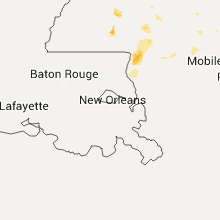
Hail Map for Saturday, August 8, 2015

Number of Impacted Households on 8/8/2015
0
Impacted by 1" or Larger Hail
0
Impacted by 1.75" or Larger Hail
0
Impacted by 2.5" or Larger Hail
Square Miles of Populated Area Impacted on 8/8/2015
0
Impacted by 1" or Larger Hail
0
Impacted by 1.75" or Larger Hail
0
Impacted by 2.5" or Larger Hail


Cities Most Affected by Hail Storms of 8/8/2015
| Hail Size | Demographics of Zip Codes Affected | ||||||
|---|---|---|---|---|---|---|---|
| City | Count | Average | Largest | Pop Density | House Value | Income | Age |
| Kettle River, MN | 1 | 1.75 | 1.75 | 7 | $48k | $32.3k | 45.0 |
| Stratton, CO | 1 | 1.75 | 1.75 | 2 | $77k | $35.0k | 37.2 |
Hail and Wind Damage Spotted on 8/8/2015
Filter by Report Type:Hail ReportsWind Reports
States Impacted
Kansas, Missouri, Florida, South Dakota, Mississippi, Alabama, Minnesota, Colorado, New Mexico, Wyoming, Texas, Louisiana, IowaKansas
| Local Time | Report Details |
|---|---|
| 7:20 AM CDT | Several trees down 6-8 inches in diameter just north of fontan in miami county KS, 47.1 miles SSW of Kansas City, MO |
| 5:15 PM CDT | 3 inch diameter tree branches fel in rush county KS, 28.5 miles SSE of Hays, KS |
| 5:44 PM CDT | Storm damage reported in finney county KS, 6.7 miles WNW of Garden City, KS |
| 7:57 PM CDT | Storm damage reported in grant county KS, 37.7 miles SW of Garden City, KS |
| 9:15 PM CDT | Quarter sized hail reported near Hays, KS, 6.2 miles N of Hays, KS |
| 10:02 PM CDT | Power lines down in town along with at least a few larger trees/branche in osborne county KS, 51.9 miles NE of Hays, KS |
| 10:02 PM CDT | Quarter sized hail reported near Osborne, KS, 51.9 miles NE of Hays, KS, nickel to quarter size hail and 50 to 60 mph winds. tree branches 2 to 3 inches in diameter down. |
| 11:38 PM CDT | Several power lines down in mound cit in linn county KS, 46.8 miles NE of Chanute, KS |
Missouri
| Local Time | Report Details |
|---|---|
| 7:47 AM CDT | Tree down 1.5 feet in diameter in bates county MO, 58.1 miles S of Kansas City, MO |
| 8:19 AM CDT | Report of damage to roofs and trees in the rich hill area. time estimated by rada in bates county MO, 66.3 miles ENE of Chanute, KS |
| 8:25 AM CDT | Trees down in the nevada area. dime size hail report in area along with some minor street floodin in vernon county MO, 61.3 miles E of Chanute, KS |
| 8:25 AM CDT | Via facebook. several big trees down uin nevada as a result of the high wind in vernon county MO, 61.3 miles E of Chanute, KS |
| 8:25 AM CDT | Trees down in the nevada area. dime size hail report in area along with some minor street floodin in vernon county MO, 61.3 miles E of Chanute, KS |
| 9:00 AM CDT | Storm damage reported in dade county MO, 37.4 miles NW of Springfield, MO |
| 9:07 AM CDT | Near south stockton lake estimates winds of 60mph. via 911 cente in cedar county MO, 43.9 miles NW of Springfield, MO |
| 9:07 AM CDT | Near south stockton lake estimates winds of 60mph. via 911 center. corrected for locatio in dade county MO, 37.4 miles NW of Springfield, MO |
| 9:45 AM CDT | 1/2 inch tree limbs dow in greene county MO, 19.9 miles NW of Springfield, MO |
| 9:45 AM CDT | 1/2 inch limbs down with winds estimated 60 mph or mor in greene county MO, 19.9 miles NW of Springfield, MO |
| 9:50 AM CDT | Farm road 56 and hwy 13 area has some power poles dow in greene county MO, 11.1 miles NNW of Springfield, MO |
| 9:52 AM CDT | Large 24 inch tree dow in greene county MO, 12.5 miles WNW of Springfield, MO |
| 9:53 AM CDT | Large trees down in the cit in greene county MO, 19.9 miles NW of Springfield, MO |
| 9:53 AM CDT | Large trees dow in polk county MO, 21.9 miles NW of Springfield, MO |
| 9:55 AM CDT | Trees snapped or uprooted and blocking private drive. several small limbs down. field flooded with small creeks flooded briefly. 1.30 inches of rai in greene county MO, 13.6 miles NNW of Springfield, MO |
| 10:00 AM CDT | Power lines physically dow in greene county MO, 8.2 miles NNW of Springfield, MO |
| 10:05 AM CDT | Powerlines dow in greene county MO, 2.8 miles N of Springfield, MO |
| 10:12 AM CDT | At least two barns damaged and one destroyed near farm rd 66 and 174 are in greene county MO, 4.9 miles N of Springfield, MO |
| 10:12 AM CDT | Nws survey team determined that maximum straight line thunderstorm winds of 95 to 100 mph caused considerable damage to trees and a couple of structures just west of fe in greene county MO, 8.4 miles NNE of Springfield, MO |
| 10:20 AM CDT | Severe thunderstorm wind gusts damaged trees south of fellows lak in greene county MO, 6.6 miles NE of Springfield, MO |
| 11:38 PM CDT | Several power lines down in mound city. corrected for locatio in holt county MO, 79.4 miles NNW of Kansas City, MO |
| 12:02 AM CDT | Quarter sized hail reported near Oregon, MO, 67.4 miles NNW of Kansas City, MO, pea size to quarter size hail. several 2 inch limbs down... flooding on hwy 59. |
| 12:10 AM CDT | Quarter sized hail reported near Fillmore, MO, 67.2 miles NNW of Kansas City, MO |
| 12:10 AM CDT | Storm damage reported in andrew county MO, 67.2 miles NNW of Kansas City, MO |
| 12:26 AM CDT | Power poles snapped at us hwy 71 and nodaway co road 400 in nodaway county MO, 72.3 miles N of Kansas City, MO |
| 12:56 AM CDT | Small branches breaking in gentry county MO, 77.1 miles N of Kansas City, MO |
Florida
| Local Time | Report Details |
|---|---|
| 4:15 PM EDT | Tree downed blocking a street and house set on fire by lightning. report received via twitte in miami-dade county FL, 9.5 miles W of Miami, FL |
South Dakota
| Local Time | Report Details |
|---|---|
| 2:47 PM MDT | Pine... birch... and aspen trees 10 to 12 in diameter down on iron creek lake roa in lawrence county SD, 42.2 miles WNW of Rapid City, SD |
| 3:10 PM MDT | Quarter sized hail reported near Spearfish, SD, 38.4 miles NW of Rapid City, SD, report via shave project |
| 3:30 PM MDT | Half Dollar sized hail reported near Spearfish, SD, 35.2 miles NW of Rapid City, SD, hail covered the ground. |
| 3:38 PM MDT | Quarter sized hail reported near Sturgis, SD, 29 miles NW of Rapid City, SD, report via shave project |
| 4:05 PM MDT | Several 1 1/2 inch metal tent pipes bent or broken at buffalo chip campgrounds in meade county SD, 24.4 miles NNW of Rapid City, SD |
| 4:05 PM MDT | Quarter sized hail reported near Sturgis, SD, 26 miles NNW of Rapid City, SD, report via shave project |
| 4:15 PM MDT | Storm damage reported in meade county SD, 28.4 miles NNW of Rapid City, SD |
| 5:05 PM MDT | Dime hail. branches broken off trees and shingles blown off hous in stanley county SD, 27.2 miles W of Pierre, SD |
| 5:17 PM MDT | Storm damage reported in pennington county SD, 9 miles ENE of Rapid City, SD |
| 5:20 PM MDT | Storm damage reported in meade county SD, 41.3 miles NE of Rapid City, SD |
| 5:30 PM MDT | Storm damage reported in meade county SD, 42.8 miles NE of Rapid City, SD |
| 5:34 PM MDT | Quarter sized hail reported near Fort Pierre, SD, 20.9 miles WNW of Pierre, SD |
| 5:34 PM MDT | Storm damage reported in stanley county SD, 20.9 miles WNW of Pierre, SD |
| 5:43 PM MDT | Camper blown over on i-90 west of new underwood in pennington county SD, 18.5 miles E of Rapid City, SD |
| 6:30 PM MDT | Storm damage reported in pennington county SD, 36.9 miles E of Rapid City, SD |
| 6:40 PM MDT | Storm damage reported in haakon county SD, 71.1 miles ENE of Rapid City, SD |
| 6:50 PM MDT | Storm damage reported in pennington county SD, 51.3 miles ESE of Rapid City, SD |
| 7:15 PM MDT | Quarter sized hail reported near Philip, SD, 65.2 miles ESE of Rapid City, SD |
| 7:15 PM MDT | Storm damage reported in jackson county SD, 65.2 miles ESE of Rapid City, SD |
| 7:16 PM MDT | Ping Pong Ball sized hail reported near Belle Fourche, SD, 50.9 miles NW of Rapid City, SD, report via twitter |
| 7:23 PM MDT | Storm damage reported in butte county SD, 50.1 miles NW of Rapid City, SD |
| 7:23 PM MDT | Quarter sized hail reported near Belle Fourche, SD, 50.1 miles NW of Rapid City, SD |
| 7:30 PM MDT | Storm damage reported in jackson county SD, 72.3 miles ESE of Rapid City, SD |
| 1:25 AM CDT | Sdsu mesonet in mellette county SD, 49 miles N of Valentine, NE |
Mississippi
| Local Time | Report Details |
|---|---|
| 4:00 PM CDT | Powerlines and trees reported down northeast of waynesbor in wayne county MS, 74.3 miles W of Camden, AL |
| 5:05 PM CDT | Numerous trees down near county road 440 and county road 67 in clarke county MS, 79.3 miles W of Camden, AL |
| 5:20 PM CDT | Numerous trees and powerlines down near county road 620 and county road 63 in wayne county MS, 73.7 miles W of Camden, AL |
| 5:55 PM CDT | Several trees down around crystal springs in copiah county MS, 23.7 miles SSW of Jackson, MS |
| 6:35 PM CDT | Numerous trees down in lawrence county MS, 40.9 miles SSE of Jackson, MS |
| 6:40 PM CDT | Trees and power lines down on highway 13 south in jefferson davis county MS, 51.1 miles SSE of Jackson, MS |
| 6:40 PM CDT | Numerous trees down near highway 42 west and oak grove rd in jefferson davis county MS, 49.6 miles SSE of Jackson, MS |
| 6:45 PM CDT | Downed power lines caused outages around town in jefferson davis county MS, 51.5 miles SSE of Jackson, MS |
| 6:50 PM CDT | Numerous trees and power poles down on dodger road in lawrence county MS, 49.3 miles SSE of Jackson, MS |
| 6:50 PM CDT | Numerous trees and power lines down on rabbit road in lawrence county MS, 49.3 miles SSE of Jackson, MS |
| 6:50 PM CDT | Numerous trees and power lines down on lucas road in jefferson davis county MS, 50.7 miles SSE of Jackson, MS |
| 6:55 PM CDT | Large oak tree fell on old highway 27. a vehicle crashed into the tree. no injurie in lawrence county MS, 51.8 miles S of Jackson, MS |
| 7:00 PM CDT | Numerous trees down in lawrence county MS, 60.6 miles SSE of Jackson, MS |
| 7:30 PM CDT | A few trees reported down around the cit in forrest county MS, 85.2 miles SE of Jackson, MS |
| 7:50 PM CDT | Sheriffs office reported numerous trees down and power outages across the entire county. most damage reported around sale in walthall county MS, 73.7 miles S of Jackson, MS |
| 8:20 PM CDT | Sheriffs dept reported numerous trees down and power outages mainly across northern portion of the count in pearl river county MS, 46.3 miles NNE of New Orleans, LA |
| 9:00 PM CDT | Reported at waveland yacht club in hancock county MS, 51.1 miles ENE of New Orleans, LA |
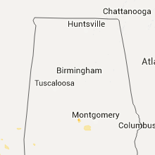
Alabama
| Local Time | Report Details |
|---|---|
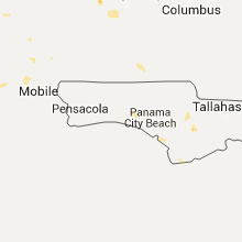
| 4:25 PM CDT | Em manager reported 6 homes severely damaged along with trees and powerlines dow in washington county AL, 55.8 miles WSW of Camden, AL |
| 5:00 PM CDT | Public reports trees/power lines down on hwy 43 near mcintos in washington county AL, 40.2 miles N of Mobile, AL |
| 5:10 PM CDT | 10-20 trees down in the selma are in dallas county AL, 34 miles NNE of Camden, AL |
| 5:30 PM CDT | Numerous public reports of trees and power lines down in and around citronelle... a in mobile county AL, 29.7 miles NNW of Mobile, AL |
| 5:40 PM CDT | Public report of tree in roadway on chunchula georgetown rd. near john shin r in mobile county AL, 19.9 miles NW of Mobile, AL |
| 5:50 PM CDT | Multiple public reports of trees and power lines down around an area centered 4 miles southwest of saraland... a in mobile county AL, 7.6 miles NNW of Mobile, AL |
| 6:29 PM CDT | Peak wind of 50kts/58mph reported at brookley filed aso in mobile county AL, 11.1 miles W of Mobile, AL |
| 6:30 PM CDT | Public report of power outage in mid-town mobile around dauphin st. and florida s in montgomery county AL, 54.8 miles SW of Auburn, AL |
Minnesota
| Local Time | Report Details |
|---|---|
| 4:30 PM CDT | Ping Pong Ball sized hail reported near Eveleth, MN, 42.8 miles NNW of Duluth, MN, a few trees down. heavy rain. |
| 4:34 PM CDT | Quarter sized hail reported near Makinen, MN, 41.2 miles NNW of Duluth, MN, lots of 1 inch hail. |
| 4:38 PM CDT | Quarter sized hail reported near Ely, MN, 78.4 miles N of Duluth, MN, mostly pea sized hail with some quarter sized hail. |
| 5:20 PM CDT | Golf Ball sized hail reported near Kettle River, MN, 42.4 miles WSW of Duluth, MN |
| 5:20 PM CDT | Trees dow in carlton county MN, 42.4 miles WSW of Duluth, MN |
| 7:54 PM CDT | Quarter sized hail reported near Grand Marais, MN, 115.3 miles NE of Duluth, MN |
Colorado
| Local Time | Report Details |
|---|---|
| 4:28 PM MDT | Quarter sized hail reported near Arapahoe, CO, 71 miles WSW of Colby, KS, some quarter along with penny sized hail...lasted about 10 minutes. |
| 4:53 PM MDT | Quarter sized hail reported near Bethune, CO, 60.6 miles SSE of Yuma, CO, hail fell for about 5 minutes |
| 5:08 PM MDT | Golf Ball sized hail reported near Stratton, CO, 57.2 miles S of Yuma, CO, hail on interstate 70...traffic stopped both ways. |
New Mexico
| Local Time | Report Details |
|---|---|
| 5:22 PM MDT | Kcvs aso in curry county NM, 59.3 miles SSE of Tucumcari, NM |
| 5:40 PM MDT | Storm damage reported in curry county NM, 60.8 miles SSE of Tucumcari, NM |
| 5:46 PM MDT | Storm damage reported in curry county NM, 60.8 miles SSE of Tucumcari, NM |
Wyoming
| Local Time | Report Details |
|---|---|
| 5:45 PM MDT | Winds of 50 to 60 mph in crook county WY, 38.3 miles ENE of Gillette, WY |
| 6:35 PM MDT | Quarter sized hail reported near Aladdin, WY, 62.3 miles NW of Rapid City, SD, mostly 1/2 hail a few pieces were 1 |
Texas
| Local Time | Report Details |
|---|---|
| 7:30 PM CDT | West texas mesonet repor in parmer county TX, 62 miles SW of Amarillo, TX |
| 8:27 PM CDT | A grain elevator was blown over and blocking hwy 87 near pollard road. further south some sprinklers were blown ove in dallam county TX, 84.2 miles NW of Amarillo, TX |
Louisiana
| Local Time | Report Details |
|---|---|
| 9:42 PM CDT | Wind gust of 67 knots report at shell beach shbl1 c-ma in st. bernard county LA, 21.7 miles ESE of New Orleans, LA |
Iowa
| Local Time | Report Details |
|---|---|
| 12:00 AM CDT | Quarter sized hail reported near Cumming, IA, 10.2 miles SW of Des Moines, IA, brief hail. most stones were nickel size but a few were size of a quarter. winds estimated to 45 mph. |
Connect with Interactive Hail Maps