

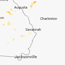
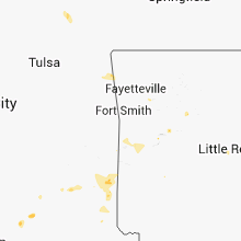
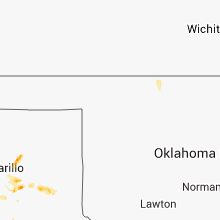
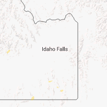
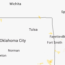
Hail Map for Friday, August 8, 2014

Number of Impacted Households on 8/8/2014
0
Impacted by 1" or Larger Hail
0
Impacted by 1.75" or Larger Hail
0
Impacted by 2.5" or Larger Hail
Square Miles of Populated Area Impacted on 8/8/2014
0
Impacted by 1" or Larger Hail
0
Impacted by 1.75" or Larger Hail
0
Impacted by 2.5" or Larger Hail


Cities Most Affected by Hail Storms of 8/8/2014
| Hail Size | Demographics of Zip Codes Affected | ||||||
|---|---|---|---|---|---|---|---|
| City | Count | Average | Largest | Pop Density | House Value | Income | Age |
| Broken Bow, NE | 2 | 1.88 | 2.00 | 12 | $57k | $31.8k | 42.8 |
| Cozad, NE | 1 | 1.75 | 1.75 | 23 | $61k | $34.0k | 40.3 |
| Claude, TX | 1 | 1.75 | 1.75 | 1 | $60k | $38.0k | 45.4 |
Hail and Wind Damage Spotted on 8/8/2014
Filter by Report Type:Hail ReportsWind Reports
States Impacted
Georgia, South Dakota, Maine, Alabama, Nebraska, Texas, Tennessee, South Carolina, Utah, Colorado, Idaho, Oklahoma, ArkansasGeorgia
| Local Time | Report Details |
|---|---|
| 2:00 PM EDT | Two trees down along hwy 49 in jones county GA, 76.4 miles SE of Atlanta, GA |
| 2:12 PM EDT | 911 center received report of a down tree on lee road and powerlines down on skyview drive in lithia spring in douglas county GA, 15.7 miles W of Atlanta, GA |
| 2:18 PM EDT | Two trees down on boones ridge parkway in bartow county GA, 28.2 miles NNW of Atlanta, GA |
| 2:44 PM EDT | Wires down along pinedale driv in clayton county GA, 9.2 miles SSE of Atlanta, GA |
| 2:53 PM EDT | Multiple trees down across fulton county - bluefield road sw and wyland dr sw... donald lee hollowell pkwy... w wesley road nw and northside dr nw... paces ferry road n in fulton county GA, 0.1 miles NNE of Atlanta, GA |
| 2:55 PM EDT | Roof collapse along empire blvd in fulton county GA, 6.1 miles S of Atlanta, GA |
| 2:55 PM EDT | Henry county 911 relayed a report of 3 to 4 trees down across northern henry county in henry county GA, 15.4 miles SE of Atlanta, GA |
| 3:17 PM EDT | Multiple trees and powerlines down across the county including along richard road... shallowford road... lagoon way... and dunleith cour in dekalb county GA, 13.4 miles ENE of Atlanta, GA |
| 3:20 PM EDT | Powerlines down on john drive and summertown driv in gwinnett county GA, 16.8 miles NE of Atlanta, GA |
| 3:30 PM EDT | A tree was reported to have fallen on top of a structure on colony oaks driv in gwinnett county GA, 22.7 miles ENE of Atlanta, GA |
| 3:30 PM EDT | Reports of powerlines down at archer high school and rafington drive at simonton roa in gwinnett county GA, 27.3 miles ENE of Atlanta, GA |
| 4:12 PM EDT | Walton county 911 relayed a report of a couple trees down and few powerlines down across the count in walton county GA, 39.3 miles E of Atlanta, GA |
| 4:25 PM EDT | Morgan county relayed a report of 3 to 4 trees down in the buckhead are in morgan county GA, 60.7 miles ESE of Atlanta, GA |
| 4:45 PM EDT | Report of 1 tree down on swords road. 2 reported power surges... 1 at 911 call center and 1 on pinfield road. several accidents were also reported in the count in greene county GA, 63.8 miles W of Augusta, GA |
| 4:55 PM EDT | Greene county 911 relayed a report of many trees down and accidents across the county at this tim in greene county GA, 69.9 miles W of Augusta, GA |
| 5:05 PM EDT | Greene county 911 relayed a report of many trees down and accidents across the county at this tim in greene county GA, 70 miles W of Augusta, GA |
| 6:00 PM EDT | Multiple trees down in the city of appling as well as on i2 in columbia county GA, 20.5 miles WNW of Augusta, GA |
| 6:10 PM EDT | Trees down on lincolnton hwy and washington road. several accidents reported on i2 in mcduffie county GA, 35.3 miles WNW of Augusta, GA |
| 6:10 PM EDT | Trees down on lincolnton hwy and washington road. several accidents reported on i2 in mcduffie county GA, 31.3 miles W of Augusta, GA |
South Dakota
| Local Time | Report Details |
|---|---|
| 1:33 PM MDT | Hail up to half-inch in size in bennett county SD, 43.5 miles WNW of Valentine, NE |
| 3:36 PM CDT | Pea to dime sized hail in todd county SD, 26.3 miles NW of Valentine, NE |
Maine
| Local Time | Report Details |
|---|---|
| 3:55 PM EDT | Numerous trees down on sandy beach shore roa in penobscot county ME, 8.4 miles NNW of Bangor, ME |
| 4:00 PM EDT | Trees and wires down in parts of tow in penobscot county ME, 10.7 miles NNE of Bangor, ME |
| 4:00 PM EDT | Trees and wires down on essex stree in penobscot county ME, 7.3 miles NE of Bangor, ME |
| 4:00 PM EDT | Trees down on kelly rd in penobscot county ME, 5.3 miles NE of Bangor, ME |
Alabama
| Local Time | Report Details |
|---|---|
| 3:20 PM CDT | Power lines down in downtown crossville in dekalb county AL, 65 miles SW of Chattanooga, TN |
| 3:40 PM CDT | Tree down blocking rifle range rd near dozier rd. time estimated from rada in elmore county AL, 39.6 miles WSW of Auburn, AL |
| 3:50 PM CDT | Tree dow in elmore county AL, 35.6 miles W of Auburn, AL |
| 4:00 PM CDT | A tree down in douglas in marshall county AL, 53 miles NNE of Birmingham, AL |
| 6:15 PM CDT | Tree down on power lines in forrest parks off hwy 280. winds estimated 40-50 mph. time estimated from rada in shelby county AL, 14.5 miles SE of Birmingham, AL |
| 7:00 PM CDT | Tree fell on a house on ranch marina rd. no injuries reported. time estimated from rada in st. clair county AL, 33 miles E of Birmingham, AL |
Nebraska
| Local Time | Report Details |
|---|---|
| 2:40 PM MDT | Quarter sized hail reported near Hemingford, NE, 23.3 miles N of Scottsbluff, NE, nickel to quarter size hail covered the ground along highway 71 |
| 3:50 PM CDT | Estimated wind gusts of at least 60 mph in cherry county NE, 12 miles WNW of Valentine, NE |
| 6:10 PM MDT | 60 to 65 mph wind gust in garden county NE, 66 miles ESE of Scottsbluff, NE |
| 7:15 PM CDT | Half Dollar sized hail reported near Anselmo, NE, 68.3 miles NE of North Platte, NE |
| 7:20 PM CDT | Quarter sized hail reported near Thedford, NE, 59.1 miles N of North Platte, NE, relayed by 911 call center |
| 7:20 PM CDT | Quarter sized hail reported near Dunning, NE, 63.2 miles NNE of North Platte, NE, relayed by 911 call center |
| 6:38 PM MDT | Quarter sized hail reported near Crawford, NE, 46.6 miles NNE of Scottsbluff, NE, hail covered ground. some stones up to 1 inch in diameter. |
| 7:45 PM CDT | Quarter sized hail reported near Dunning, NE, 59 miles NE of North Platte, NE, visibility under 1/8 mile |
| 7:45 PM CDT | ...2 inj... inflatable kids playhouse collapsed due to wind in holt county NE, 17.9 miles SSW of Oneill, NE |
| 7:50 PM CDT | Half Dollar sized hail reported near Dunning, NE, 59 miles NE of North Platte, NE, also heavy rains... which led to water running in the ditches. |
| 8:10 PM CDT | Hen Egg sized hail reported near Broken Bow, NE, 68.7 miles ENE of North Platte, NE |
| 8:28 PM CDT | Golf Ball sized hail reported near Broken Bow, NE, 65.4 miles ENE of North Platte, NE |
| 8:51 PM CDT | Quarter sized hail reported near Broken Bow, NE, 63.6 miles E of North Platte, NE |
| 8:00 PM MDT | Storm damage reported in chase county NE, 62.6 miles SW of North Platte, NE |
| 8:07 PM MDT | Sustained wnw winds at 33 mph with wind gust of 61 mph at aso in chase county NE, 62.6 miles SW of North Platte, NE |
| 10:40 PM CDT | Quarter sized hail reported near Amherst, NE, 49.1 miles W of Grand Island, NE, spotter reported quarter sized hail with winds of 50 mph. |
| 11:15 PM CDT | Quarter sized hail reported near Kearney, NE, 40.3 miles WSW of Grand Island, NE, est wind gusts to around 30 mph. hail the size of quarters currently falling. |
| 11:52 PM CDT | Est 60 mph outflow wind gust from storm chaser 6 north of minde in kearney county NE, 39.5 miles SW of Grand Island, NE |
| 11:53 PM CDT | Estimated 60 mph in furnas county NE, 72.8 miles SE of North Platte, NE |
| 12:10 AM CDT | Estimated 60 mph on east side of oxford in harlan county NE, 81.4 miles SW of Grand Island, NE |
| 4:31 AM CDT | Golf Ball sized hail reported near Cozad, NE, 49.5 miles ESE of North Platte, NE, photo and report of quarter to golf ball hail posted on facebook. time and location estimated from radar data. |
Texas
| Local Time | Report Details |
|---|---|
| 4:00 PM CDT | Golf Ball sized hail reported near Claude, TX, 18.1 miles E of Amarillo, TX |
| 4:58 PM CDT | Trees/power lines and utility poles down east of lindsay into parts of gainesville. estimated 70 mph winds in cooke county TX, 63.3 miles NNW of Dallas, TX |
| 5:04 PM CDT | Quarter sized hail reported near Borger, TX, 39.8 miles NE of Amarillo, TX, also reported 0.36 inches of rain in 10 minutes. |
| 5:05 PM CDT | Power poles/lines down at gainesville airport. gainesville airport reported 53 mph gust then lost powe in cooke county TX, 62.2 miles NNW of Dallas, TX |
| 6:20 PM CDT | West texas mesonet report in cottle county TX, 37.9 miles SSW of Childress, TX |
| 6:25 PM CDT | Additional info...roof lifted from trailer house. roof lifted from old restaurant. more than 100 trees damaged. 5 carports lifted. 2 vehicles trapped below fallen carpo in donley county TX, 53.6 miles ESE of Amarillo, TX |
| 6:36 PM CDT | Roof blown off building and large tree limbs broken in tow in donley county TX, 53.6 miles ESE of Amarillo, TX |
| 6:57 PM CDT | Chaser video feed showed a large tree down across county road 20. time is estimated based on radar. the same feed shows another tree down on fm 1260 about 6 miles north in donley county TX, 52.4 miles NW of Childress, TX |
Tennessee
| Local Time | Report Details |
|---|---|
| 4:14 PM CDT | Trees down nw of winchester in franklin county TN, 50 miles WNW of Chattanooga, TN |
| 4:19 PM CDT | Trees down south of winchester in franklin county TN, 46.1 miles W of Chattanooga, TN |
| 4:19 PM CDT | Trees down on iron gap roa in franklin county TN, 46.6 miles W of Chattanooga, TN |
| 4:27 PM CDT | Trees and power lines are dow in grundy county TN, 29 miles WNW of Chattanooga, TN |
| 4:45 PM CDT | Several trees dow in marion county TN, 32.1 miles WNW of Chattanooga, TN |
South Carolina
| Local Time | Report Details |
|---|---|
| 6:45 PM EDT | Mccormick county dispatch reported trees down on lost wilderness road... gilchrist ferry road... and old plum branch roa in mccormick county SC, 14.2 miles NW of Augusta, GA |
| 7:02 PM EDT | Sc highway patrol reported trees down on syrup mill rd. at blythewood rd. time estimated based on rada in richland county SC, 70.3 miles S of Charlotte, NC |
| 7:45 PM EDT | Public measured 64 mph wind gust... reported tree down and reported 3/4 inch hai in lexington county SC, 52 miles ENE of Augusta, GA |
| 8:10 PM EDT | Sc highway patrol reported a tree in the roadway at lady street and oak stree in richland county SC, 66.1 miles NE of Augusta, GA |
| 8:15 PM EDT | Asos station columbia hamilton-owens downtown airport reported a gust of 60 mp in richland county SC, 65.6 miles ENE of Augusta, GA |
| 8:20 PM EDT | Quarter sized hail reported near Columbia, SC, 73.5 miles ENE of Augusta, GA, quarter size hail reported at wltx television station and dime size hail seen across the street at the va hospital in columiba. |
| 9:12 PM EDT | Sc highway patrol reported trees down on syrup mill rd. at blythewood rd. time estimated based on rada in richland county SC, 70.3 miles S of Charlotte, NC |
Utah
| Local Time | Report Details |
|---|---|
| 4:50 PM MDT | Rosebud raws rsbu1...time estimate in box elder county UT, 79.4 miles SE of Twin Falls, ID |
Colorado
| Local Time | Report Details |
|---|---|
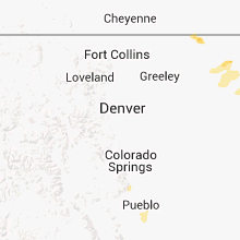
| 5:23 PM MDT | Quarter sized hail reported near Yuma, CO, 8.3 miles NE of Yuma, CO |
Idaho
| Local Time | Report Details |
|---|---|
| 6:20 PM MDT | Big southern summi in butte county ID, 49.6 miles W of Idaho Falls, ID |
Oklahoma
| Local Time | Report Details |
|---|---|
| 7:44 PM CDT | Few large limbs down. relayed via medi in delaware county OK, 74.7 miles ENE of Tulsa, OK |
| 7:45 PM CDT | Quarter sized hail reported near Bokchito, OK, 38.4 miles S of Atoka, OK, reported in yuba |
| 9:00 PM CDT | Trees down between smithville and watson in mccurtain county OK, 54.4 miles NW of Nashville, AR |
| 9:41 PM CDT | Trees down in hochatown in mccurtain county OK, 50.3 miles WNW of Nashville, AR |
| 10:15 PM CDT | Tree down blocking us highway 259 near the harris area in mccurtain county OK, 52.6 miles WSW of Nashville, AR |
| 10:27 PM CDT | Tree down in haworth... oklahom in mccurtain county OK, 46.7 miles W of Nashville, AR |
Arkansas
| Local Time | Report Details |
|---|---|
| 8:47 PM CDT | Tree down in lockesbur in sevier county AR, 18.6 miles W of Nashville, AR |
Connect with Interactive Hail Maps