

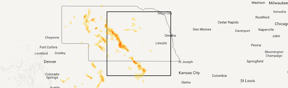
Hail Map for Saturday, August 9, 2014
Number of Impacted Households on 8/9/2014
0
Impacted by 1" or Larger Hail
0
Impacted by 1.75" or Larger Hail
0
Impacted by 2.5" or Larger Hail
Square Miles of Populated Area Impacted on 8/9/2014
0
Impacted by 1" or Larger Hail
0
Impacted by 1.75" or Larger Hail
0
Impacted by 2.5" or Larger Hail


Cities Most Affected by Hail Storms of 8/9/2014
| Hail Size | Demographics of Zip Codes Affected | ||||||
|---|---|---|---|---|---|---|---|
| City | Count | Average | Largest | Pop Density | House Value | Income | Age |
| Lebanon, KS | 3 | 2.08 | 2.75 | 2 | $14k | $28.4k | 52.1 |
| Thedford, NE | 2 | 2.75 | 2.75 | 0 | $39k | $31.7k | 46.4 |
| Lexington, NE | 2 | 2.25 | 2.75 | 46 | $64k | $38.3k | 30.8 |
| Callaway, NE | 1 | 2.00 | 2.00 | 2 | $54k | $33.0k | 47.3 |
| Whitman, NE | 1 | 1.75 | 1.75 | 0 | $22k | $33.4k | 35.5 |
| Hershey, NE | 1 | 1.75 | 1.75 | 4 | $78k | $42.2k | 42.2 |
| Elm Creek, NE | 1 | 1.75 | 1.75 | 6 | $76k | $36.9k | 38.1 |
Hail and Wind Damage Spotted on 8/9/2014
Filter by Report Type:Hail ReportsWind Reports
States Impacted
Nebraska, Florida, Mississippi, Alabama, Oklahoma, South Carolina, Arkansas, South Dakota, Kansas, Colorado, Georgia, Texas, Louisiana, Arizona, New MexicoNebraska
| Local Time | Report Details |
|---|---|
| 9:12 AM CDT | Quarter sized hail reported near Burwell, NE, 52.4 miles SSW of Oneill, NE |
| 9:12 AM CDT | Quarter sized hail reported near Burwell, NE, 52.4 miles SSW of Oneill, NE |
| 3:26 PM CDT | Baseball sized hail reported near Thedford, NE, 54.9 miles N of North Platte, NE, golfball to baseball hail at time of report...along with very heavy rain. |
| 3:35 PM CDT | Baseball sized hail reported near Thedford, NE, 54.9 miles N of North Platte, NE, baseball sized hail occurred again at 335 pm cdt. very heavy rain still occurring. ground completely white. |
| 4:22 PM CDT | Quarter sized hail reported near Stapleton, NE, 36.3 miles NNE of North Platte, NE, estimated wind gusts to 40 mph along with quarter sized hail and very heavy rain. |
| 4:27 PM CDT | Quarter sized hail reported near Thedford, NE, 52.9 miles N of North Platte, NE, dime to quarter sized hail occurring. |
| 4:33 PM MDT | Golf Ball sized hail reported near Whitman, NE, 61 miles NW of North Platte, NE |
| 6:10 PM CDT | Half Dollar sized hail reported near Tryon, NE, 27.2 miles N of North Platte, NE |
| 5:33 PM MDT | Quarter sized hail reported near Ashby, NE, 81.9 miles WSW of Valentine, NE, most hail stones were nickel to quarter size |
| 6:45 PM CDT | Hen Egg sized hail reported near Callaway, NE, 41.4 miles ENE of North Platte, NE, relayed via social media |
| 6:47 PM CDT | Half Dollar sized hail reported near Callaway, NE, 38.8 miles ENE of North Platte, NE, very heavy rain at time of report along with the hail. |
| 7:25 PM CDT | Ping Pong Ball sized hail reported near Callaway, NE, 45.2 miles ENE of North Platte, NE |
| 7:46 PM CDT | Quarter sized hail reported near Hershey, NE, 16 miles WNW of North Platte, NE, very heavy rain at time of report. |
| 7:57 PM CDT | Half Dollar sized hail reported near Hershey, NE, 12.5 miles W of North Platte, NE, quarter to half dollar sized hail along with very heavy rain. visibility 1/4 mile or less. |
| 7:57 PM CDT | Ping Pong Ball sized hail reported near Oconto, NE, 52.6 miles E of North Platte, NE, along with ping ball sized hail...very heavy rain occurring. 2.03 inches rainfall so far at time of this report. |
| 8:00 PM CDT | Quarter sized hail reported near Hershey, NE, 10.8 miles WSW of North Platte, NE, very heavy rain occurring at time of report. |
| 8:02 PM CDT | Quarter sized hail reported near Lexington, NE, 58.9 miles ESE of North Platte, NE, officer reported pea to quarter sized hail |
| 8:04 PM CDT | Golf Ball sized hail reported near Hershey, NE, 11.9 miles W of North Platte, NE |
| 7:10 PM MDT | Estimated 40 to 60 mph wind gusts...with dime sized hai in grant county NE, 78.4 miles NW of North Platte, NE |
| 8:12 PM CDT | Ping Pong Ball sized hail reported near Lexington, NE, 59.8 miles ESE of North Platte, NE |
| 8:14 PM CDT | Golf Ball sized hail reported near Lexington, NE, 59.8 miles ESE of North Platte, NE, pea size hail up to quarter and occasionally golf ball size hail. |
| 8:16 PM CDT | Baseball sized hail reported near Lexington, NE, 61.8 miles ESE of North Platte, NE, golf ball to baseball sized hail ongoing. estimated 55 mph wind gusts. |
| 8:34 PM CDT | Ping Pong Ball sized hail reported near North Platte, NE, 7.3 miles SSW of North Platte, NE, hail ranged from quarter to ping pong ball size |
| 8:50 PM CDT | Quarter sized hail reported near Elm Creek, NE, 56.3 miles WSW of Grand Island, NE, quarter sized hail falling in elm creek with wind gusts of 30 to 40 mph. |
| 7:56 PM MDT | Ping Pong Ball sized hail reported near Elsie, NE, 35.2 miles WSW of North Platte, NE, pea...marble...up to a few ping pong sized hail stones. very heavy rain at time of report. |
| 8:58 PM CDT | Golf Ball sized hail reported near Elm Creek, NE, 56.3 miles WSW of Grand Island, NE, pea to golf ball sized hail falling with 20 to 25 mph wind gusts. |
| 10:14 PM CDT | Mesonet site in hall county NE, 15.8 miles WSW of Grand Island, NE |
| 10:18 PM CDT | Storm damage reported in hall county NE, 18.7 miles SW of Grand Island, NE |
| 10:31 PM CDT | Storm damage reported in adams county NE, 22.9 miles SSW of Grand Island, NE |
| 10:32 PM CDT | Via spotter networ in adams county NE, 21.2 miles S of Grand Island, NE |
| 10:48 PM CDT | Officer est 60 mph wind gust in town in webster county NE, 43.9 miles SSW of Grand Island, NE |
Florida
| Local Time | Report Details |
|---|---|
| 1:00 PM CDT | 1 tree and 1 power line down. time estimated using rada in holmes county FL, 49.6 miles NE of Miramar Beach, FL |
| 3:48 PM EDT | Multiple trees blown down in the vicinity of cypress circle to the southeast of greesboro. time is estimated from rada in gadsden county FL, 25.6 miles WNW of Tallahassee, FL |
Mississippi
| Local Time | Report Details |
|---|---|
| 1:05 PM CDT | Power lines were downed along babylon rd in oktibbeha county MS, 3.4 miles WNW of Starkville, MS |
| 1:35 PM CDT | Tree downed on mt elam rd in madison county MS, 22.9 miles N of Jackson, MS |
| 1:45 PM CDT | Strong winds snapped off the top of a tree in hinds county MS, 9.2 miles WNW of Jackson, MS |
| 2:00 PM CDT | Trees downed along chartres st in the bourgeois subdivision in rankin county MS, 12.6 miles ENE of Jackson, MS |
| 2:00 PM CDT | Multiple utility lines downed in the city of jackson in hinds county MS, 2.3 miles NW of Jackson, MS |
| 3:19 PM CDT | Tree down on highway 43n between mendenhall and pinol in simpson county MS, 30.9 miles SSE of Jackson, MS |
| 4:05 PM CDT | Tree down near intersection of hwy 535 and hwy 58 in covington county MS, 64.5 miles SE of Jackson, MS |
Alabama
| Local Time | Report Details |
|---|---|
| 2:15 PM CDT | Two trees were blown down along state highway 9 north of wetumpka. winds were estimated by the emergency manager to be 30 to 40 mp in elmore county AL, 40.8 miles W of Auburn, AL |
| 3:30 PM CDT | Roof damage reported at several local businesse in mobile county AL, 9.3 miles N of Mobile, AL |
| 3:30 PM CDT | Trees reported down on top of a house and cars in prichard... alabam in mobile county AL, 4.3 miles NNW of Mobile, AL |
Oklahoma
| Local Time | Report Details |
|---|---|
| 2:17 PM CDT | Half of a mile stretch along highway 112 with multiple trees and power lines dow in le flore county OK, 19.5 miles SSW of Fort Smith, AR |
| 5:45 PM CDT | Wind gusts peeled back the roof of the outdoor stage at the okc downtown airpark events center... as well as a large ten in oklahoma county OK, 0.6 miles ESE of Oklahoma City, OK |
South Carolina
| Local Time | Report Details |
|---|---|
| 3:32 PM EDT | Public reported large tree branch down in avondale. diameter unknow in charleston county SC, 27.3 miles S of Charleston, SC |
Arkansas
| Local Time | Report Details |
|---|---|
| 3:24 PM CDT | Trees and power lines were blown down in the city of paris...and just east of pari in logan county AR, 40.1 miles E of Fort Smith, AR |
| 3:35 PM CDT | Winds broke off the top of a small tre in johnson county AR, 59.9 miles E of Fort Smith, AR |
| 3:35 PM CDT | Trees were blown down at clarksvill in johnson county AR, 53.9 miles E of Fort Smith, AR |
| 3:54 PM CDT | Trees and power lines were blown dow in pope county AR, 65.3 miles NW of Little Rock, AR |
| 3:54 PM CDT | Trees were blown down on highway 27 about three miles west of dardanell in yell county AR, 63.1 miles WNW of Little Rock, AR |
| 4:00 PM CDT | A tree was blown down in russellville. emergency dispatch has also received reports of trees and power lines down in areas around the count in pope county AR, 60.8 miles NW of Little Rock, AR |
South Dakota
| Local Time | Report Details |
|---|---|
| 2:28 PM MDT | Quarter sized hail reported near Hot Springs, SD, 43.3 miles SSW of Rapid City, SD, hail covered ground |
| 3:15 PM MDT | Trees bending over in fall river county SD, 51.4 miles S of Rapid City, SD |
| 3:15 PM MDT | Quarter sized hail reported near Hot Springs, SD, 51.4 miles S of Rapid City, SD |
Kansas
| Local Time | Report Details |
|---|---|
| 3:57 PM CDT | Quarter sized hail reported near Saint Francis, KS, 47.8 miles WNW of Colby, KS, half mile south of st francis |
| 3:50 PM MDT | Storm damage reported in wallace county KS, 58.8 miles WSW of Colby, KS |
| 4:22 PM MDT | Storm damage reported in wallace county KS, 50.2 miles SW of Colby, KS |
| 6:13 PM CDT | Pea-sized hail as well in thomas county KS, 0.6 miles SSW of Colby, KS |
| 7:10 PM CDT | Quarter sized hail reported near Manter, KS, 61.1 miles WSW of Garden City, KS, most of the hail has been pea size or a little larger. |
| 6:48 PM MDT | Report from the syracuse awo in hamilton county KS, 47.9 miles W of Garden City, KS |
| 8:05 PM CDT | Storm damage reported in kearny county KS, 30.7 miles W of Garden City, KS |
| 8:12 PM CDT | Officer reported a wind gust of 60 mph north of bellaire in smith county KS, 74.8 miles NNE of Hays, KS |
| 8:14 PM CDT | Quarter sized hail reported near Lebanon, KS, 75 miles SSW of Grand Island, NE |
| 8:16 PM CDT | Storm damage reported in smith county KS, 67.9 miles NNE of Hays, KS |
| 8:22 PM CDT | Golf Ball sized hail reported near Lebanon, KS, 75 miles SSW of Grand Island, NE, hail has been ongoing for over 10 minutes and just increased to golf ball sized. |
| 8:23 PM CDT | Storm damage reported in smith county KS, 67.9 miles NNE of Hays, KS |
| 8:24 PM CDT | Estimated 70-80 mph winds and golf ball sized hai in smith county KS, 75.8 miles NNE of Hays, KS |
| 8:27 PM CDT | Golf Ball sized hail reported near Lebanon, KS, 76.9 miles NNE of Hays, KS |
| 8:30 PM CDT | Half Dollar sized hail reported near Lebanon, KS, 76.9 miles NNE of Hays, KS, half dollar sized hail ongoing for 10 minutes. spotter located ne side of town. |
| 8:47 PM CDT | 14 power poles down and many tree limbs down in smith county KS, 75.1 miles NNE of Hays, KS |
| 8:47 PM CDT | Baseball sized hail reported near Lebanon, KS, 75.1 miles NNE of Hays, KS |
| 8:50 PM CDT | Estimate 60 mph wind gusts peaking about 850 pm. 2 inch diameter branches down. estimated dime sized hail and very heavy rai in jewell county KS, 72.8 miles S of Grand Island, NE |
| 9:40 PM CDT | Quarter sized hail reported near Beloit, KS, 81.2 miles WNW of Manhattan, KS, radar est time |
| 9:44 PM CDT | Est 50 to 60 mph winds with nickle sized hail in mitchell county KS, 76.3 miles NE of Hays, KS |
| 9:46 PM CDT | This is a kdot repor in finney county KS, 1.9 miles ENE of Garden City, KS |
| 10:44 PM CDT | Storm damage reported in ford county KS, 51.1 miles ESE of Garden City, KS |
| 11:00 PM CDT | A semi-trailer was blown over on highway 400... 2 miles west of dodge cit in ford county KS, 47.3 miles ESE of Garden City, KS |
Colorado
| Local Time | Report Details |
|---|---|
| 3:10 PM MDT | Storm damage reported in kit carson county CO, 63.9 miles WSW of Colby, KS |
| 3:41 PM MDT | Storm damage reported in elbert county CO, 68.1 miles ESE of Denver, CO |
| 3:51 PM MDT | Storm damage reported in elbert county CO, 68.1 miles ESE of Denver, CO |
Georgia
| Local Time | Report Details |
|---|---|
| 6:50 PM EDT | Douglas county 911 relayed a report of a couple power lines down in the county along with a couple house fires from lightnin in douglas county GA, 20.8 miles W of Atlanta, GA |
| 7:30 PM EDT | Fulton county ema relayed a report of trees down in fulton county. trees were down at 3470 and 3505 riverly rd nw...1307 beecher st sw and 501 connell ave s in fulton county GA, 0.1 miles NNE of Atlanta, GA |
Texas
| Local Time | Report Details |
|---|---|
| 6:12 PM CDT | Recorded at kgle awo in cooke county TX, 63.9 miles NNW of Dallas, TX |
Louisiana
| Local Time | Report Details |
|---|---|
| 6:47 PM CDT | Trees down...power lines down in claiborne county LA, 55.3 miles ENE of Shreveport, LA |
Arizona
| Local Time | Report Details |
|---|---|
| 5:08 PM MST | Quarter sized hail reported near Douglas, AZ, 6.6 miles WNW of Douglas, AZ, spotter reports quarter sized hail |
| 5:08 PM MST | Half Dollar sized hail reported near Douglas, AZ, 6.6 miles WNW of Douglas, AZ, spotter reports half dollar sized hail |
New Mexico
| Local Time | Report Details |
|---|---|
| 7:35 PM MDT | Ktcs observation from thunderstorm outflo in sierra county NM, 66.4 miles ENE of Silver City, NM |
Connect with Interactive Hail Maps