

Hail Map for Wednesday, December 15, 2021

Number of Impacted Households on 12/15/2021
0
Impacted by 1" or Larger Hail
0
Impacted by 1.75" or Larger Hail
0
Impacted by 2.5" or Larger Hail
Square Miles of Populated Area Impacted on 12/15/2021
0
Impacted by 1" or Larger Hail
0
Impacted by 1.75" or Larger Hail
0
Impacted by 2.5" or Larger Hail


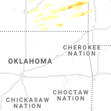

Cities Most Affected by Hail Storms of 12/15/2021
| Hail Size | Demographics of Zip Codes Affected | ||||||
|---|---|---|---|---|---|---|---|
| City | Count | Average | Largest | Pop Density | House Value | Income | Age |
| Emporia, KS | 4 | 2.56 | 4.00 | 99 | $71k | $32.1k | 30.7 |
| Quenemo, KS | 1 | 1.75 | 1.75 | 11 | $42k | $33.5k | 38.0 |
| Vassar, KS | 1 | 1.75 | 1.75 | 75 | $86k | $50.8k | 47.9 |
| Maryville, MO | 1 | 1.75 | 1.75 | 93 | $91k | $32.0k | 24.0 |
Hail and Wind Damage Spotted on 12/15/2021
Filter by Report Type:Hail ReportsWind Reports
States Impacted
New Mexico, Colorado, Oklahoma, Kansas, Nebraska, Missouri, Iowa, Minnesota, Wisconsin, Illinois, MichiganNew Mexico
| Local Time | Report Details |
|---|---|
| 6:11 AM MST | Storm damage reported in santa fe county NM, 46.8 miles NE of Albuquerque, NM |
| 6:15 AM MST | Radio tower downed... taking out power lines for the northern half of town. mobile home blown off foundation along with another one burned down. several roofs blown off in taos county NM, 1.5 miles SSW of Taos, NM |
| 6:25 AM MST | Tree damage at roundhous in santa fe county NM, 54.4 miles SSW of Taos, NM |
| 6:30 AM MST | Large evergreen tree toppled outside of st francis cathedra in santa fe county NM, 53.8 miles SSW of Taos, NM |
Colorado
| Local Time | Report Details |
|---|---|
| 7:24 AM MST | Storm damage reported in pueblo county CO, 6.6 miles ENE of Pueblo, CO |
| 8:04 AM MST | Small tree limbs broke in adams county CO, 19.7 miles NNE of Denver, CO |
| 8:19 AM MST | 1-inch tree limbs broke in arapahoe county CO, 7.8 miles ESE of Denver, CO |
| 10:21 AM MST | Hwy 287 is closed from springfield to wiley due to crashes and power lines dow in baca county CO, 103.2 miles WSW of Garden City, KS |
| 10:35 AM MST | 1-inch tree limbs broke in jefferson county CO, 8.6 miles WSW of Denver, CO |
| 10:41 AM MST | Report from mping: 1-inch tree limbs broke in jefferson county CO, 5 miles SW of Denver, CO |
| 1:34 PM MST | Report from mping: 3-inch tree limbs broken; power poles broke in el paso county CO, 49 miles S of Denver, CO |
| 1:39 PM MST | Report from mping: 3-inch tree limbs broken; power poles broke in el paso county CO, 42 miles NNW of Pueblo, CO |
Oklahoma
| Local Time | Report Details |
|---|---|
| 11:35 AM CST | Storm damage reported in woods county OK, 46.7 miles ENE of Woodward, OK |
Kansas
| Local Time | Report Details |
|---|---|
| 12:05 PM CST | Report from mping: 1-inch tree limbs broken; shingles blown of in harvey county KS, 29.4 miles NW of Wichita, KS |
| 12:32 PM CST | Report from mping: 1-inch tree limbs broken; shingles blown of in shawnee county KS, 48.2 miles E of Manhattan, KS |
| 12:55 PM CST | Storm damage reported in phillips county KS, 48.3 miles N of Hays, KS |
| 1:00 PM CST | Storm damage reported in phillips county KS, 78 miles N of Hays, KS |
| 1:00 PM CST | Storm damage reported in rooks county KS, 32.4 miles NNE of Hays, KS |
| 1:40 PM CST | Reports of some tree limbs down and a couple touching houses. no wind speed estimate given. time was estimated from rada in osborne county KS, 60.8 miles NE of Hays, KS |
| 1:46 PM CST | Very poor visibility noted as wel in lincoln county KS, 64.7 miles E of Hays, KS |
| 1:51 PM CST | Storm damage reported in lincoln county KS, 53.1 miles ENE of Hays, KS |
| 1:55 PM CST | Storm damage reported in barton county KS, 54.7 miles SE of Hays, KS |
| 2:00 PM CST | Delayed report of tree damage via em photo. time estimated from rada in jewell county KS, 78.6 miles S of Grand Island, NE |
| 2:19 PM CST | Power line with transformer down leaning in lincoln center at 5th and lost st. railroad crossing arm snapped. scattered reports of fallen smaller tree limb in lincoln county KS, 64.7 miles E of Hays, KS |
| 2:28 PM CST | Large ash tree down. bent metal basketball pole in hal in republic county KS, 81.3 miles SSE of Grand Island, NE |
| 2:31 PM CST | Corrects previous tstm wnd gst report from 2 sse concordi in cloud county KS, 63.7 miles WNW of Manhattan, KS |
| 2:32 PM CST | 4 inch tree limbs dow in ottawa county KS, 67.6 miles W of Manhattan, KS |
| 2:34 PM CST | Storm damage reported in saline county KS, 73.3 miles WSW of Manhattan, KS |
| 2:34 PM CST | Corrects previous tstm wnd dmg report from 5 e delphos. blown-over semi at mile marker 183 on us-81. delayed report. corrected time based off of rada in ottawa county KS, 59.9 miles W of Manhattan, KS |
| 2:35 PM CST | Storm damage reported in cloud county KS, 63.7 miles WNW of Manhattan, KS |
| 2:40 PM CST | Mesonet station k5cnc us-81 @ republican r. concordi in cloud county KS, 64.7 miles WNW of Manhattan, KS |
| 2:40 PM CST | Corrects previous tstm wnd dmg report from minneapolis. power lines and transformers down. time estimated from rada in ottawa county KS, 61.8 miles W of Manhattan, KS |
| 2:40 PM CST | Storm damage reported in ottawa county KS, 66 miles WSW of Manhattan, KS |
| 2:40 PM CST | Sustained at 50kts as wel in russell county KS, 28.2 miles E of Hays, KS |
| 2:45 PM CST | Tin roof rolled back on building... 6 inch tree limbs down... and fence dow in ottawa county KS, 66 miles WSW of Manhattan, KS |
| 2:47 PM CST | Corrects previous tstm wnd dmg report from 3 wsw bennington. blown-over semi at mile marker 165 on us-81. delayed report. time corrected based on radar dat in ottawa county KS, 59 miles W of Manhattan, KS |
| 2:54 PM CST | Storm damage reported in saline county KS, 64.2 miles WSW of Manhattan, KS |
| 2:55 PM CST | Report from mping: 3-inch tree limbs broken; power poles broke in butler county KS, 20 miles E of Wichita, KS |
| 2:56 PM CST | Storm damage reported in cloud county KS, 49.1 miles WNW of Manhattan, KS |
| 2:56 PM CST | Pea sized hail... 8in diameter tree down... 0 visibility from blowing dust and dir in cloud county KS, 53.1 miles WNW of Manhattan, KS |
| 3:00 PM CST | Mesonet station ew5822 clay cente in clay county KS, 31.5 miles WNW of Manhattan, KS |
| 3:02 PM CST | Two 8 inch limbs are dow in republic county KS, 57.1 miles NW of Manhattan, KS |
| 3:14 PM CST | Dead trees knocked over... 12 inch diamete in washington county KS, 56 miles NW of Manhattan, KS |
| 3:18 PM CST | Metal grain bins damaged; time estimate in clay county KS, 32.2 miles WNW of Manhattan, KS |
| 3:22 PM CST | Storm damage reported in rice county KS, 65.7 miles NW of Wichita, KS |
| 3:26 PM CST | 1-ft diameter tree snapped... visibility 1 1/2 mile in ellsworth county KS, 74 miles E of Hays, KS |
| 3:32 PM CST | Storm damage reported in ellsworth county KS, 60.2 miles E of Hays, KS |
| 3:39 PM CST | Awos station kfri ft riley marsha in geary county KS, 15.2 miles SW of Manhattan, KS |
| 3:40 PM CST | Report from mping: trees uprooted or snapped; roof blown of in russell county KS, 25.5 miles E of Hays, KS |
| 3:43 PM CST | Trees dow in harvey county KS, 24.3 miles N of Wichita, KS |
| 3:45 PM CST | Social media post showed half of 12 inch diameter tree blown dow in riley county KS, 2.2 miles WNW of Manhattan, KS |
| 3:46 PM CST | Report from mping: 3-inch tree limbs broken; power poles broke in wilson county KS, 22.3 miles SW of Chanute, KS |
| 3:47 PM CST | Metal signs bent... siding off buildings... damage to hangers at junction city airpor in geary county KS, 17.8 miles WSW of Manhattan, KS |
| 3:49 PM CST | Em reports severe damage. motel roof blown off and into other buildings... power outages. time estimated from rada in geary county KS, 16 miles SW of Manhattan, KS |
| 3:52 PM CST | Asos station kmhk manhatta in riley county KS, 7.2 miles WSW of Manhattan, KS |
| 3:53 PM CST | 7 inch tree limb down. 70 mph wind in dickinson county KS, 40.9 miles SSW of Manhattan, KS |
| 3:58 PM CST | Storm damage reported in harvey county KS, 26 miles N of Wichita, KS |
| 3:58 PM CST | Delayed report from mping: trees uprooted or snapped; roof blown of in riley county KS, 1.7 miles WNW of Manhattan, KS |
| 4:00 PM CST | Blown-over semi at mile marker 165 on us-81. delayed repor in ottawa county KS, 59 miles W of Manhattan, KS |
| 4:04 PM CST | Delayed report from mping: 3-inch tree limbs broken; power poles broke in riley county KS, 2.2 miles WNW of Manhattan, KS |
| 4:08 PM CST | Roofs peeling off buildings... side of metal building got blown ou in morris county KS, 28.2 miles SSW of Manhattan, KS |
| 4:15 PM CST | Storm damage reported in wabaunsee county KS, 10.4 miles ESE of Manhattan, KS |
| 4:20 PM CST | Storm damage reported in nemaha county KS, 40.2 miles NE of Manhattan, KS |
| 4:30 PM CST | Tree limbs down and light poles knocked over. delayed report. time estimated by rada in chase county KS, 55.1 miles S of Manhattan, KS |
| 4:30 PM CST | Blown-over semi at mile marker 183 on us-81. delayed repor in ottawa county KS, 59.9 miles W of Manhattan, KS |
| 4:40 PM CST | Storm damage reported in butler county KS, 30.4 miles ENE of Wichita, KS |
| 4:41 PM CST | Delayed report from mping: 1-inch tree limbs broken; shingles blown of in lyon county KS, 57.3 miles SSE of Manhattan, KS |
| 4:43 PM CST | Storm damage reported in jackson county KS, 45.6 miles ENE of Manhattan, KS |
| 4:47 PM CST | Grapefruit sized hail reported near Emporia, KS, 58.5 miles SSE of Manhattan, KS, softball-sized hail reported at mile marker 137 off i-35. time estimated from radar. |
| 4:48 PM CST | Storm damage reported in greenwood county KS, 47.3 miles WNW of Chanute, KS |
| 4:49 PM CST | Quarter sized hail reported near Emporia, KS, 56.9 miles SSE of Manhattan, KS, quarter sized hail. |
| 4:50 PM CST | Delayed report from mping: 1-inch tree limbs broken; shingles blown of in shawnee county KS, 42.9 miles ESE of Manhattan, KS |
| 4:51 PM CST | Tennis Ball sized hail reported near Emporia, KS, 58.1 miles SSE of Manhattan, KS, tennis-ball size hail reported at i-35/r1 east of emporia. time estimated from radar. |
| 4:52 PM CST | Quarter sized hail reported near Emporia, KS, 57.3 miles SSE of Manhattan, KS, delayed report from mping: quarter (1.00 in.). |
| 4:53 PM CST | Asos station kemp empori in lyon county KS, 60.5 miles NW of Chanute, KS |
| 4:53 PM CST | Golf Ball sized hail reported near Emporia, KS, 58.8 miles SSE of Manhattan, KS, golf ball sized hail reported at fanestil original plant on k-99. time estimated from radar. |
| 4:54 PM CST | Delayed report from mping: 1-inch tree limbs broken; shingles blown of in brown county KS, 60.9 miles NW of Kansas City, MO |
| 4:55 PM CST | Several power poles snappe in lyon county KS, 50.1 miles SSE of Manhattan, KS |
| 4:55 PM CST | Storm damage reported in greenwood county KS, 47.3 miles WNW of Chanute, KS |
| 4:56 PM CST | Storm damage reported in lyon county KS, 57.6 miles SSE of Manhattan, KS |
| 5:00 PM CST | Corrects previous tstm wnd gst report from matfield gree in chase county KS, 53.5 miles NE of Wichita, KS |
| 5:00 PM CST | Hen Egg sized hail reported near Emporia, KS, 58.3 miles SSE of Manhattan, KS, apricot-sized hail. |
| 5:00 PM CST | Delayed report from mping: 3-inch tree limbs broken; power poles broke in shawnee county KS, 48.8 miles ESE of Manhattan, KS |
| 5:04 PM CST | Delayed report from mping: 3-inch tree limbs broken; power poles broke in lyon county KS, 55.5 miles SSE of Manhattan, KS |
| 5:04 PM CST | Asos station ktop topek in shawnee county KS, 50.6 miles E of Manhattan, KS |
| 5:14 PM CST | Delayed report: mesonet station k5006 i-470 bridge over us-7 in shawnee county KS, 48.6 miles ESE of Manhattan, KS |
| 5:15 PM CST | Delayed report from mping: 3-inch tree limbs broken; power poles broke in brown county KS, 60.9 miles NW of Kansas City, MO |
| 5:15 PM CST | Damage to a power pole at 286th and neosh in atchison county KS, 46.2 miles NW of Kansas City, MO |
| 5:15 PM CST | Roof damage to building at 294th and kingma in atchison county KS, 49.8 miles NW of Kansas City, MO |
| 5:15 PM CST | Storm damage reported in jefferson county KS, 45.5 miles W of Kansas City, MO |
| 5:16 PM CST | Delayed report: mesonet station fw2032 valley fall in jefferson county KS, 51.6 miles WNW of Kansas City, MO |
| 5:17 PM CST | Multiple power poles down... large barn blown down at topeka and union st. time estimated from rada in jefferson county KS, 40.3 miles W of Kansas City, MO |
| 5:18 PM CST | Large tree completely across 122nd road one-half mile east of k4 highwa in jefferson county KS, 51.1 miles WNW of Kansas City, MO |
| 5:20 PM CST | Multiple power poles down... tree damage across cit in jefferson county KS, 43.4 miles W of Kansas City, MO |
| 5:20 PM CST | Golf Ball sized hail reported near Vassar, KS, 63.3 miles WSW of Kansas City, MO, delayed report. |
| 5:22 PM CST | Golf Ball sized hail reported near Quenemo, KS, 62.1 miles N of Chanute, KS |
| 5:24 PM CST | Quarter sized hail reported near Pomona, KS, 54.2 miles WSW of Kansas City, MO, em reports 1-inch hail at 4104 delaware rd near pomona. time estimated from radar. |
| 5:30 PM CST | Em report of pea size hail and heavy rain with 70 mph wind in leavenworth county KS, 29.6 miles WNW of Kansas City, MO |
| 5:30 PM CST | Power lines down near mt. olivet road and 179th. law enforcement responding. time estimated via rada in leavenworth county KS, 27.3 miles NW of Kansas City, MO |
| 5:31 PM CST | Relayed by emergency management... several storm spotters reporting 70 mph wind in leavenworth county KS, 32 miles NW of Kansas City, MO |
| 5:35 PM CST | Roof off of traile in douglas county KS, 39.1 miles SW of Kansas City, MO |
| 5:35 PM CST | Delayed report: awos station kowi ottaw in franklin county KS, 53.5 miles SW of Kansas City, MO |
| 5:35 PM CST | Delayed public report. small branches down in the area... around 1-2 inches in diameter. many heavy... unsecured outdoor objects have been blown around. power lines als in douglas county KS, 36 miles WSW of Kansas City, MO |
| 5:37 PM CST | Delayed report: mesonet station up091 1.9 e williamstown (upr in jefferson county KS, 38.7 miles W of Kansas City, MO |
| 5:37 PM CST | Report of power line down and wrapped around trampoline. emergency responders en route. no injuries reporte in leavenworth county KS, 20.2 miles WNW of Kansas City, MO |
| 5:40 PM CST | Lwc aso in douglas county KS, 34.9 miles W of Kansas City, MO |
| 5:42 PM CST | Report of power line down by tree and on fire. time estimated via rada in leavenworth county KS, 26 miles W of Kansas City, MO |
| 5:46 PM CST | Corrects previous tstm wnd dmg report from neodesha. report from mping: 3-inch tree limbs broken; power poles broke in wilson county KS, 22.3 miles SW of Chanute, KS |
| 5:47 PM CST | Storm damage reported in neosho county KS, 2.3 miles WSW of Chanute, KS |
| 5:48 PM CST | Merriam police report multiple trees and power lines down. time estimated from radar and social medi in johnson county KS, 7.7 miles SW of Kansas City, MO |
| 5:50 PM CST | Several outbuildings with roofs blown off. time estimated via rada in leavenworth county KS, 29.3 miles WNW of Kansas City, MO |
| 5:52 PM CST | Quarter sized hail reported near Olathe, KS, 22.7 miles SW of Kansas City, MO, report via social media. time estimated via radar. |
| 5:54 PM CST | Tree on house near 83rd and corliss rd... de soto ks. time estimated via rada in johnson county KS, 21 miles WSW of Kansas City, MO |
| 6:01 PM CST | Storm damage reported in anderson county KS, 27.2 miles N of Chanute, KS |
| 6:01 PM CST | Tree on house near w 67th st and nieman rd. time estimated via rada in johnson county KS, 9.8 miles SW of Kansas City, MO |
| 6:01 PM CST | Delayed report: large tree fell on a house causing roof damag in cowley county KS, 24.7 miles SE of Wichita, KS |
| 6:22 PM CST | Storm damage reported in allen county KS, 13.5 miles NNE of Chanute, KS |
| 6:24 PM CST | Storm damage reported in wilson county KS, 19 miles WSW of Chanute, KS |
| 6:27 PM CST | Zero visibilit in allen county KS, 22 miles NE of Chanute, KS |
| 6:28 PM CST | Storm damage reported in chase county KS, 53.5 miles NE of Wichita, KS |
| 6:30 PM CST | Ping Pong Ball sized hail reported near Elk City, KS, 36.3 miles SW of Chanute, KS, north of town on us160. |
| 6:37 PM CST | Lots of trees downed between iola and humboldt on 1100. winds estimated between 60-70 mp in allen county KS, 12.3 miles N of Chanute, KS |
| 6:51 PM CST | Three inch tree limbs broken; power poles broken. via mpin in montgomery county KS, 31 miles SSW of Chanute, KS |
| 7:02 PM CST | Report from mping: 1-inch tree limbs broken; shingles blown of in montgomery county KS, 37.8 miles SSW of Chanute, KS |
Nebraska
| Local Time | Report Details |
|---|---|
| 12:59 PM CST | Storm damage reported in harlan county NE, 81 miles SW of Grand Island, NE |
| 12:59 PM CST | Wind damage in alma... including tree limbs down... some shingle and roof damage... some small outbuildings destroyed and reports of power lines down. time estimated fr in harlan county NE, 78.3 miles SW of Grand Island, NE |
| 1:00 PM CST | Storm damage reported in harlan county NE, 77.6 miles SW of Grand Island, NE |
| 1:11 PM CST | Storm damage reported in harlan county NE, 62.9 miles SW of Grand Island, NE |
| 1:15 PM CST | Storm damage reported in harlan county NE, 70.2 miles SW of Grand Island, NE |
| 1:15 PM CST | Storm damage reported in phelps county NE, 61.9 miles WSW of Grand Island, NE |
| 1:15 PM CST | Storm damage reported in kearney county NE, 57.7 miles SW of Grand Island, NE |
| 1:25 PM CST | Storm damage reported in kearney county NE, 43.9 miles SW of Grand Island, NE |
| 1:28 PM CST | Storm damage reported in kearney county NE, 43.8 miles WSW of Grand Island, NE |
| 1:31 PM CST | Ntv video of powerlines down near 11th st. and m ave. time estimated from rada in buffalo county NE, 41.6 miles WSW of Grand Island, NE |
| 1:33 PM CST | Storm damage reported in kearney county NE, 34.8 miles SW of Grand Island, NE |
| 1:33 PM CST | Delayed report of outbuilding damage and a flipped pivot. time estimated from radar data. possible tornado per radar data but not confirmed at this tim in webster county NE, 48.6 miles SSW of Grand Island, NE |
| 1:36 PM CST | Storm damage reported in webster county NE, 54.5 miles SSW of Grand Island, NE |
| 1:40 PM CST | Home damaged at powerline road and south wanda avenue. possible tornado damage but unknown at this time. time estimated from rada in adams county NE, 39.9 miles SSW of Grand Island, NE |
| 1:40 PM CST | Fairly widespread damage in and around gibbon. reports of roof damage... especially in trailer park. grain bin destroyed in town. several pivots flipped north of tow in buffalo county NE, 28.8 miles WSW of Grand Island, NE |
| 1:49 PM CST | Delayed report of power poles downed at marian road and cimarron road. time estimated from rada in adams county NE, 35.8 miles S of Grand Island, NE |
| 1:50 PM CST | Report of semi overturned at highway 6 annd adams central. time estimated from rada in adams county NE, 25.3 miles SSW of Grand Island, NE |
| 1:52 PM CST | Storm damage reported in adams county NE, 31.5 miles S of Grand Island, NE |
| 2:00 PM CST | Damage to wood fence. estimated gusts around 60-70 mp in hall county NE, 10.7 miles S of Grand Island, NE |
| 2:07 PM CST | Spotter est 80-90mph wind gusts along hwy 281 and 13th st. also reported pea to quarter sized hai in hall county NE, 2.1 miles W of Grand Island, NE |
| 2:10 PM CST | Storm damage reported in hall county NE, 3.5 miles NNE of Grand Island, NE |
| 2:11 PM CST | Estimated 80-90 mph wind in hamilton county NE, 14.1 miles SE of Grand Island, NE |
| 2:15 PM CST | Storm damage reported in nuckolls county NE, 61.8 miles SSE of Grand Island, NE |
| 2:19 PM CST | Reports of various wind damage in southwest part of aurora including large tree down... stadium bleachers overturned... some structural damage to various buildings. tim in hamilton county NE, 18.3 miles ESE of Grand Island, NE |
| 2:23 PM CST | 70mph winds with heavy rains vis was 0 when rain hi in clay county NE, 36.1 miles SE of Grand Island, NE |
| 2:23 PM CST | Report of pickup and trailer overturned on westbound i-80 east of locust exi in hall county NE, 7.3 miles S of Grand Island, NE |
| 2:23 PM CST | Powerlines down in town. time estimated from rada in clay county NE, 44.7 miles SE of Grand Island, NE |
| 2:25 PM CST | Trees and powerlines down in sutton from estimated 80 mph winds. time estimated from rada in clay county NE, 33.2 miles SE of Grand Island, NE |
| 2:25 PM CST | Estimated 65 mph winds with windows blown out of vehicles on main street. time estimated from rada in hamilton county NE, 23.8 miles E of Grand Island, NE |
| 2:25 PM CST | Delayed report. photos received via facebook showing damage to pivots. time estimated from radar and other nearby report in thayer county NE, 51.9 miles SSE of Grand Island, NE |
| 2:28 PM CST | Storm damage reported in thayer county NE, 49.9 miles SE of Grand Island, NE |
| 2:29 PM CST | Storm damage reported in fillmore county NE, 45.9 miles SE of Grand Island, NE |
| 2:29 PM CST | Storm damage reported in nance county NE, 34 miles NNE of Grand Island, NE |
| 2:30 PM CST | Delayed social media report of damage to powerlines and large trees and possibly a house roughly near road 21 and road b. possible tornado damage but cannot be confirme in york county NE, 28 miles E of Grand Island, NE |
| 2:31 PM CST | Irrigation pivots overturned in the area of 25 and x road. possible tornado damage but unconfirmed at this time. time estimated from rada in hamilton county NE, 26.5 miles ENE of Grand Island, NE |
| 2:32 PM CST | Storm damage reported in merrick county NE, 23.7 miles NE of Grand Island, NE |
| 2:32 PM CST | Irrigation pivot damage. time estimated from rada in york county NE, 30.9 miles E of Grand Island, NE |
| 2:34 PM CST | Delayed report via twitter. complete loss of roof of shed. small outbuilding destroyed. time estimated from rada in nance county NE, 36.9 miles NNE of Grand Island, NE |
| 2:36 PM CST | Damage reported along and near highway 66 from 2 to 4 miles east of polk. mainly numerous irrigation pivots and a few outbuildings. time estimated from radar data. unkn in polk county NE, 32.6 miles ENE of Grand Island, NE |
| 2:37 PM CST | 2 large pine trees uprooted at the courthous in thayer county NE, 65.3 miles SE of Grand Island, NE |
| 2:40 PM CST | Carport picked up by winds and blew it into some power lines. 3-4 inch limbs are down in town also. blowing dust also dropping vis to 1/2s in thayer county NE, 57.1 miles SE of Grand Island, NE |
| 2:48 PM CST | Pea sized hail with 60-70mph wind in polk county NE, 44.9 miles ENE of Grand Island, NE |
| 2:50 PM CST | Pivots overturned and barn damaged in area. time estimated from rada in york county NE, 46.7 miles E of Grand Island, NE |
| 2:50 PM CST | Roof blown off hom in platte county NE, 62.2 miles NE of Grand Island, NE |
| 2:52 PM CST | Overturned 5th wheel traile in platte county NE, 62.2 miles NE of Grand Island, NE |
| 2:52 PM CST | Storm damage reported in polk county NE, 40.5 miles ENE of Grand Island, NE |
| 2:55 PM CST | Power lines blown dow in jefferson county NE, 74.1 miles NNW of Manhattan, KS |
| 2:55 PM CST | Semi blown ove in jefferson county NE, 76.9 miles NNW of Manhattan, KS |
| 2:56 PM CST | Semi truck blown over on highway 13 in jefferson county NE, 74.3 miles SE of Grand Island, NE |
| 2:59 PM CST | Mesonet station ur416 hedri in jefferson county NE, 75.6 miles SE of Grand Island, NE |
| 2:59 PM CST | Mesonet station at fairbur in jefferson county NE, 74.2 miles NNW of Manhattan, KS |
| 3:00 PM CST | Storm damage reported in jefferson county NE, 74.2 miles NNW of Manhattan, KS |
| 3:00 PM CST | Wind strong enough to break limbs that are 2-3 inches. hail was nickel siz in saline county NE, 61.6 miles ESE of Grand Island, NE |
| 3:00 PM CST | Storm damage reported in york county NE, 50.2 miles E of Grand Island, NE |
| 3:01 PM CST | Roof torn off hom in platte county NE, 61.9 miles NE of Grand Island, NE |
| 3:02 PM CST | Delayed report. numerous pivots overturned throughout the count in jefferson county NE, 74.1 miles NNW of Manhattan, KS |
| 3:04 PM CST | Half Dollar sized hail reported near Columbus, NE, 62.2 miles NE of Grand Island, NE |
| 3:05 PM CST | Half Dollar sized hail reported near Columbus, NE, 62.7 miles NE of Grand Island, NE |
| 3:09 PM CST | Power line dow in jefferson county NE, 76.1 miles SE of Grand Island, NE |
| 3:14 PM CST | Storm damage reported in platte county NE, 63.1 miles NE of Grand Island, NE |
| 3:14 PM CST | Delayed report... time estimated from radar. damage to outbuildings and barns in the plymouth are in jefferson county NE, 80.6 miles NNW of Manhattan, KS |
| 3:15 PM CST | From personal weather statio in butler county NE, 60.4 miles W of Omaha, NE |
| 3:19 PM CST | Mesonet station up948 2.5 w schuyler (upr in colfax county NE, 62.2 miles WNW of Omaha, NE |
| 3:21 PM CST | From a personal weather statio in lancaster county NE, 48.4 miles SW of Omaha, NE |
| 3:27 PM CST | Wind gust to 76 mph along with penny sized hai in colfax county NE, 63.8 miles WNW of Omaha, NE |
| 3:30 PM CST | Storm damage reported in lancaster county NE, 51.3 miles WSW of Omaha, NE |
| 3:32 PM CST | Delayed report... time estimated from radar. report from mping: 3-inch tree limbs broken; power poles broke in lancaster county NE, 56.5 miles SW of Omaha, NE |
| 3:35 PM CST | Partial roof blown of in colfax county NE, 63.8 miles WNW of Omaha, NE |
| 3:35 PM CST | Storm damage reported in gage county NE, 76.6 miles N of Manhattan, KS |
| 3:37 PM CST | Delayed report... time estimated from radar. several large trees snapped or uprooted. no damage to buildings at the residenc in lancaster county NE, 41 miles WSW of Omaha, NE |
| 3:40 PM CST | Report of roof blown off apartment buildin in lancaster county NE, 47.1 miles WSW of Omaha, NE |
| 3:40 PM CST | Almost 20' tree blown over and patio furniture tossed around near dento in lancaster county NE, 59.2 miles SW of Omaha, NE |
| 3:41 PM CST | Delayed report... time estimated from radar. report from mping: 3-inch tree limbs broken; power poles broke in saunders county NE, 36.1 miles WSW of Omaha, NE |
| 3:44 PM CST | Storm damage reported in lancaster county NE, 49.9 miles SW of Omaha, NE |
| 3:46 PM CST | Delayed report... time estimated from radar. report from mping: trees uprooted or snapped; roof blown of in otoe county NE, 54.7 miles SSW of Omaha, NE |
| 3:46 PM CST | Delayed report... time estimated from radar. report from mping: 3-inch tree limbs broken; power poles broke in cuming county NE, 65.1 miles NW of Omaha, NE |
| 3:49 PM CST | Storm damage reported in cass county NE, 39.7 miles SW of Omaha, NE |
| 3:50 PM CST | Mesonet station nb075 memphis 4 in saunders county NE, 27.1 miles WSW of Omaha, NE |
| 3:56 PM CST | Storm damage reported in otoe county NE, 38.1 miles SSW of Omaha, NE |
| 3:56 PM CST | Storm damage reported in otoe county NE, 38.7 miles SSW of Omaha, NE |
| 3:56 PM CST | Delayed report... time estimated from radar. report from mping: 3-inch tree limbs broken; power poles broke in burt county NE, 48.2 miles NNW of Omaha, NE |
| 3:57 PM CST | Storm damage reported in pawnee county NE, 72.7 miles N of Manhattan, KS |
| 3:57 PM CST | Roof blown off and power lines down in tow in saunders county NE, 36.1 miles WNW of Omaha, NE |
| 3:59 PM CST | Storm damage reported in burt county NE, 36.7 miles NNW of Omaha, NE |
| 3:59 PM CST | Tractor trailer blown over on its side. numerous trees down in fremon in dodge county NE, 32.3 miles WNW of Omaha, NE |
| 4:00 PM CST | Storm damage reported in dodge county NE, 32.4 miles WNW of Omaha, NE |
| 4:01 PM CST | Report from mping: 3-inch tree limbs broken; power poles broke in lancaster county NE, 46.7 miles SW of Omaha, NE |
| 4:01 PM CST | Barn and grain bins destroyed. trees snapped. additional damage to trees and power lines across other parts of otoe county as wel in otoe county NE, 35.2 miles S of Omaha, NE |
| 4:03 PM CST | Storm damage reported in douglas county NE, 22.7 miles W of Omaha, NE |
| 4:04 PM CST | Power lines down and thunderstorm wind damage along highway 9 in saunders county NE, 26.1 miles W of Omaha, NE |
| 4:08 PM CST | Roof blown away at beaver lak in cass county NE, 23 miles S of Omaha, NE |
| 4:10 PM CST | Storm damage reported in washington county NE, 25 miles WNW of Omaha, NE |
| 4:10 PM CST | Lots of structure damage... roof damage... carports damage in pawnee county NE, 67.9 miles NNE of Manhattan, KS |
| 4:10 PM CST | Electric pole blown down. time estimated from rada in dakota county NE, 69.6 miles WSW of Storm Lake, IA |
| 4:11 PM CST | Report from mping: 3-inch tree limbs broken; power poles broke in burt county NE, 48.2 miles NNW of Omaha, NE |
| 4:12 PM CST | Several large tree limbs dow in douglas county NE, 6 miles NNW of Omaha, NE |
| 4:13 PM CST | Numerous large trees down and homes damage in sarpy county NE, 7 miles S of Omaha, NE |
| 4:13 PM CST | Delayed report... time estimated from radar. limbs down near 30th and harriso in sarpy county NE, 5 miles SSW of Omaha, NE |
| 4:14 PM CST | Mesonet station up945 2.2 s murray (upr in cass county NE, 25.6 miles S of Omaha, NE |
| 4:15 PM CST | Branches down more than 6 inches in diamete in douglas county NE, 8.3 miles WNW of Omaha, NE |
| 4:15 PM CST | Delayed report... time estimated from radar. report from mping: 3-inch tree limbs broken; power poles broke in nemaha county NE, 61 miles S of Omaha, NE |
| 4:16 PM CST | Large limb crushed car. fence dow in sarpy county NE, 7 miles S of Omaha, NE |
| 4:22 PM CST | Storm damage reported in sarpy county NE, 9.8 miles S of Omaha, NE |
| 4:26 PM CST | Recorded at eppley airfiel in douglas county NE, 3.8 miles NE of Omaha, NE |
| 4:27 PM CST | Large diameter tree broken in hal in douglas county NE, 9.1 miles NW of Omaha, NE |
| 4:30 PM CST | Large diameter trees dow in nemaha county NE, 60.3 miles S of Omaha, NE |
| 4:33 PM CST | Windows blown out and roof damag in cass county NE, 23.5 miles S of Omaha, NE |
| 4:41 PM CST | Corrects previous tstm wnd dmg report from 1 ssw omaha. residential building collapse due to heavy tree falling on a hous in douglas county NE, 4.2 miles W of Omaha, NE |
| 4:44 PM CST | Roof blown off hom in douglas county NE, 8.6 miles WSW of Omaha, NE |
| 5:03 PM CST | Delayed report... time estimated from radar. report from mping: 3-inch tree limbs broken; power poles broke in otoe county NE, 40.2 miles S of Omaha, NE |
| 5:03 PM CST | Delayed report... time estimated from radar. report from mping: 3-inch tree limbs broken; power poles broke in otoe county NE, 40.2 miles S of Omaha, NE |
| 5:05 PM CST | Large trees uprooted... roofs blown off outbuildings and lots of dust blowing up from kansa in johnson county NE, 59.9 miles SSW of Omaha, NE |
| 5:40 PM CST | Mesonet station ew0351 lincol in lancaster county NE, 52.9 miles SW of Omaha, NE |
| 5:53 PM CST | Area bound by highway 31 & highway 75 between kennard and fort calhoun. multiple large tree branches down... roof blown off machine shed and 1 camper flipped ove in washington county NE, 17.5 miles NW of Omaha, NE |
Missouri
| Local Time | Report Details |
|---|---|
| 1:01 PM CST | Report from mping: 3-inch tree limbs broken; power poles broke in clinton county MO, 37.7 miles NNE of Kansas City, MO |
| 4:27 PM CST | Corrects previous non-tstm wnd gst report from 2 n watso in atchison county MO, 54.5 miles SSE of Omaha, NE |
| 4:37 PM CST | Corrects previous non-tstm wnd gst report from 1 w tarkio. trained spotter repor in atchison county MO, 63.3 miles SSE of Omaha, NE |
| 4:48 PM CST | Trained spotter reported 70 mph winds relayed to us by law enforcemen in atchison county MO, 63.3 miles SSE of Omaha, NE |
| 4:51 PM CST | Trained spotter reported 90 mph winds relayed by law enforcemen in atchison county MO, 63.3 miles SSE of Omaha, NE |
| 4:51 PM CST | Trained spotter reported 90 mph winds relayed by law enforcemen in atchison county MO, 71.6 miles SSE of Omaha, NE |
| 5:12 PM CST | Damage to outbuildings reporte in nodaway county MO, 74.3 miles SE of Omaha, NE |
| 5:17 PM CST | Debris in the roadway and light poles down. time estimated from rada in nodaway county MO, 83.9 miles SE of Omaha, NE |
| 5:17 PM CST | Golf Ball sized hail reported near Maryville, MO, 84.8 miles SE of Omaha, NE, golf ball sized hail reported on south main street. power lines and trees down in town. reported by law enforcement relayed by emergency management. |
| 6:00 PM CST | Several power poles down and an estimated 2500 people out of powe in jackson county MO, 9.4 miles E of Kansas City, MO |
| 6:06 PM CST | Report of people trapped in a cellar with house collapsed on top. law enforcement and fire department respondin in clinton county MO, 45 miles NNE of Kansas City, MO |
| 6:06 PM CST | Power lines down near nw 56th st and interstate 29. time estimated via rada in platte county MO, 7 miles NNW of Kansas City, MO |
| 6:09 PM CST | Storm damage reported in clay county MO, 1.5 miles NW of Kansas City, MO |
| 6:10 PM CST | Quarter sized hail reported near Kansas City, MO, 9.1 miles NNW of Kansas City, MO |
| 6:19 PM CST | Report of carport and lean to blown ove in daviess county MO, 75.9 miles NNE of Kansas City, MO |
| 6:20 PM CST | Large tree down blocking highway 116 west of plattsbur in clinton county MO, 32.2 miles NNE of Kansas City, MO |
| 6:23 PM CST | Report of power poles down in bethany. time estimated via rada in harrison county MO, 85.9 miles NNE of Kansas City, MO |
| 6:29 PM CST | Multiple windows blown out and shingles removed from roof. two 6 to 8 inch diameter trees blown dow in clay county MO, 27.9 miles NE of Kansas City, MO |
| 6:39 PM CST | Storm damage reported in grundy county MO, 83.3 miles NNE of Kansas City, MO |
| 6:45 PM CST | Storm damage reported in jackson county MO, 21.5 miles SSE of Kansas City, MO |
| 6:46 PM CST | Numerous trees... power lines... and signs blown down in trenton. part of roof blown off in downtow in grundy county MO, 85.1 miles NE of Kansas City, MO |
| 6:53 PM CST | Estimated wind gust at nws kansas cit in cass county MO, 26.7 miles SE of Kansas City, MO |
| 6:55 PM CST | Several trees down in southeast trento in grundy county MO, 84.9 miles NE of Kansas City, MO |
| 7:06 PM CST | State troopers car pushed off the road. time estimated based on rada in putnam county MO, 79.5 miles SSE of Des Moines, IA |
| 7:17 PM CST | Storm damage reported in johnson county MO, 44.5 miles SE of Kansas City, MO |
| 7:24 PM CST | Estimated 75 to 80 mph winds reported as storms moved through unionvill in putnam county MO, 68.1 miles W of Kahoka, MO |
| 7:30 PM CST | Most of the roof to an automotive repair facility was blown off. time estimated from rada in linn county MO, 70 miles NW of Columbia, MO |
| 8:09 PM CST | Storm damage reported in pettis county MO, 48.6 miles WSW of Columbia, MO |
| 8:35 PM CST | Kmb in randolph county MO, 36.1 miles N of Columbia, MO |
| 8:41 PM CST | 1.5 foot diameter tree blown dow in lewis county MO, 23.1 miles SSW of Kahoka, MO |
| 8:44 PM CST | Tree blown down onto route f at intersection with stidham roa in boone county MO, 15 miles NNW of Columbia, MO |
| 8:53 PM CST | Ten inch diameter tree blown over onto old highway 63 near dripping springs roa in boone county MO, 9.5 miles N of Columbia, MO |
| 8:59 PM CST | Power lines down at providence and wilke in boone county MO, 0.6 miles NNE of Columbia, MO |
| 8:59 PM CST | Several trees blown down across old plank road near intersection with route k. the trees are over a foot in diamete in boone county MO, 4.3 miles S of Columbia, MO |
| 9:00 PM CST | Street light snapped and blocking roadway at 7th and cherr in boone county MO, 0.3 miles SE of Columbia, MO |
| 9:06 PM CST | Tree was blown over onto roadway at intersection of highway ww and s. rangeline roa in boone county MO, 7.6 miles ESE of Columbia, MO |
Iowa
| Local Time | Report Details |
|---|---|
| 4:19 PM CST | Overturned propane tanks. time estimated from rada in woodbury county IA, 54.2 miles WSW of Storm Lake, IA |
| 4:20 PM CST | Mesonet station rcbi4 council bluffs (i-80 in pottawattamie county IA, 4.2 miles ESE of Omaha, NE |
| 4:20 PM CST | Building damaged. time estimated from rada in woodbury county IA, 57.7 miles WSW of Storm Lake, IA |
| 4:21 PM CST | Roofs off a couple of homes between sergeant bluff and bronson. time estimated from rada in woodbury county IA, 59.1 miles WSW of Storm Lake, IA |
| 4:21 PM CST | Nine loaded coal cars rolled off track in pottawattamie county IA, 4.9 miles ESE of Omaha, NE |
| 4:22 PM CST | Mesonet station up118 2.2 w missouri valley (upr in harrison county IA, 20.7 miles N of Omaha, NE |
| 4:22 PM CST | Mesonet station near sidney at i29/hwy in fremont county IA, 40.3 miles SSE of Omaha, NE |
| 4:22 PM CST | Storm damage reported in harrison county IA, 20.8 miles N of Omaha, NE |
| 4:22 PM CST | Power lines across highway 3 in mills county IA, 24.2 miles SE of Omaha, NE |
| 4:23 PM CST | Storm damage reported in woodbury county IA, 62.3 miles WSW of Storm Lake, IA |
| 4:24 PM CST | Fire chief reported power lines and poles down for about a 1/4 mile from homestead ave to l-34 along railroad highwa in pottawattamie county IA, 10.1 miles ENE of Omaha, NE |
| 4:24 PM CST | Damage to buildin in woodbury county IA, 57.6 miles WSW of Storm Lake, IA |
| 4:25 PM CST | Major home damage in westo in pottawattamie county IA, 11.8 miles ENE of Omaha, NE |
| 4:27 PM CST | Powerlines dow in pottawattamie county IA, 16.8 miles E of Omaha, NE |
| 4:29 PM CST | Large tree on hous in pottawattamie county IA, 21 miles E of Omaha, NE |
| 4:29 PM CST | Roof blown off a house on l-34 west of underwoo in pottawattamie county IA, 13 miles NE of Omaha, NE |
| 4:31 PM CST | Pole shed roof off with debris blown into field. time estimated from rada in woodbury county IA, 49.6 miles WSW of Storm Lake, IA |
| 4:31 PM CST | Power lines down across hwy 20. time estimated from rada in woodbury county IA, 49.8 miles WSW of Storm Lake, IA |
| 4:34 PM CST | Delayed report... time estimated from radar. report from mping: trees uprooted or snapped; roof blown of in harrison county IA, 30.9 miles NNE of Omaha, NE |
| 4:34 PM CST | Cattle barn and garage damaged. time estimated from rada in woodbury county IA, 38.9 miles WSW of Storm Lake, IA |
| 4:35 PM CST | Roof town off of building. time estimated from rada in plymouth county IA, 39 miles W of Storm Lake, IA |
| 4:36 PM CST | Storm damage reported in pottawattamie county IA, 9.4 miles E of Omaha, NE |
| 4:38 PM CST | Storm damage reported in pottawattamie county IA, 16.1 miles ENE of Omaha, NE |
| 4:38 PM CST | Large garage doors on city building blown i in pottawattamie county IA, 16.7 miles ENE of Omaha, NE |
| 4:41 PM CST | Large tree fell on hom in shelby county IA, 35 miles NE of Omaha, NE |
| 4:43 PM CST | Machine shed damaged. time estimated from rada in ida county IA, 30.5 miles SW of Storm Lake, IA |
| 4:48 PM CST | Machine shed damage. time estimated from rada in ida county IA, 24.7 miles SW of Storm Lake, IA |
| 4:50 PM CST | Mesonet station ravi4 avoca (i-80 in pottawattamie county IA, 37.6 miles ENE of Omaha, NE |
| 4:50 PM CST | Trees down. time estimated from rada in ida county IA, 22.1 miles SW of Storm Lake, IA |
| 4:52 PM CST | Machine shed destroyed and gravity wagon tipped over. report via social medi in cherokee county IA, 29 miles WNW of Storm Lake, IA |
| 4:53 PM CST | Trees uprooted or snapped; roof blown of in harrison county IA, 33.4 miles NNE of Omaha, NE |
| 4:53 PM CST | Semi rolled over on i-80w per twitter phot in pottawattamie county IA, 31.3 miles ENE of Omaha, NE |
| 4:55 PM CST | Storm damage reported in shelby county IA, 41.5 miles NE of Omaha, NE |
| 4:55 PM CST | Awos station kdns denison airpor in crawford county IA, 47.6 miles S of Storm Lake, IA |
| 4:56 PM CST | Roofs were blown off of a few buildings and semi was blown off the road. time estimated from rada in cherokee county IA, 32.9 miles WNW of Storm Lake, IA |
| 4:57 PM CST | House damaged with roof torn off. hoop barn destroyed and 100 year old marchine shed destoyed. time estimated from rada in ida county IA, 14.2 miles SW of Storm Lake, IA |
| 5:00 PM CST | Power lines across highway 3 in mills county IA, 24.2 miles SE of Omaha, NE |
| 5:00 PM CST | Powerlines dow in pottawattamie county IA, 16.8 miles E of Omaha, NE |
| 5:02 PM CST | Semi rolled over. i-80w 13 mm near mcclelland... i in pottawattamie county IA, 11.5 miles ENE of Omaha, NE |
| 5:03 PM CST | Silo damaged... trees down and sheet metal from buildings on road. power out in town. time estimated from rada in cherokee county IA, 12.9 miles WNW of Storm Lake, IA |
| 5:04 PM CST | Damage to machine sheds and some roofs damage. time estimated from rada in cherokee county IA, 23 miles NW of Storm Lake, IA |
| 5:10 PM CST | Destroyed building blocking highway 10 south of sutherland. time estimated from rada in o'brien county IA, 25.5 miles NW of Storm Lake, IA |
| 5:11 PM CST | Large tree branch down in town. time estimated from rada in o'brien county IA, 26.7 miles NNW of Storm Lake, IA |
| 5:11 PM CST | Pws recorded wind gust of 88 mp in audubon county IA, 61.3 miles ENE of Omaha, NE |
| 5:12 PM CST | Pws recorded a 76 mph wind gus in adair county IA, 53.5 miles W of Des Moines, IA |
| 5:15 PM CST | Storm damage reported in page county IA, 60.5 miles SE of Omaha, NE |
| 5:15 PM CST | Em reports 80+ mph winds... zero visibility south of adai in adair county IA, 53.7 miles W of Des Moines, IA |
| 5:17 PM CST | Em reports 1/2 inch hail and estimated 65 mph wind... hwy 44 and frontier road in guthrie c in guthrie county IA, 53.8 miles W of Des Moines, IA |
| 5:22 PM CST | Tree on roadway. us-6 38 m in pottawattamie county IA, 36.7 miles E of Omaha, NE |
| 5:23 PM CST | Quarter sized hail reported near Coon Rapids, IA, 58.3 miles WNW of Des Moines, IA |
| 5:24 PM CST | Tree on road ia-92 at 8 mm & eastern hills driv in pottawattamie county IA, 9.1 miles ESE of Omaha, NE |
| 5:25 PM CST | Storm damage reported in guthrie county IA, 44.6 miles WNW of Des Moines, IA |
| 5:25 PM CST | Large pine tree blow down. time estimated from rada in clay county IA, 29.2 miles N of Storm Lake, IA |
| 5:27 PM CST | Pws recorded wind gust of 73 mp in greene county IA, 54.6 miles WNW of Des Moines, IA |
| 5:27 PM CST | Storm damage reported in carroll county IA, 58.3 miles WNW of Des Moines, IA |
| 5:27 PM CST | Lamoni municipal airport recorded 52 kt wind gus in decatur county IA, 67.9 miles SSW of Des Moines, IA |
| 5:31 PM CST | Wind estimates of at least 70 mph from ralston fire dept. some sporadic damage beginning to occu in carroll county IA, 50.8 miles SE of Storm Lake, IA |
| 5:31 PM CST | Trees down in town. time estimated from rada in clay county IA, 34.1 miles N of Storm Lake, IA |
| 5:32 PM CST | Report of an outbuilding destroye in guthrie county IA, 40.7 miles WNW of Des Moines, IA |
| 5:34 PM CST | Semi rollover. i-29n at 35 m in mills county IA, 15.8 miles SSE of Omaha, NE |
| 5:34 PM CST | Out buildings blown over... houses damaged... power lines down... gas leak - tds noted in the area on rada in pottawattamie county IA, 21.2 miles NE of Omaha, NE |
| 5:35 PM CST | Outbuilding destroyed at 240th st. and timber ave. size of building unknow in carroll county IA, 50.2 miles SSE of Storm Lake, IA |
| 5:35 PM CST | Storm damage reported in dickinson county IA, 44.7 miles N of Storm Lake, IA |
| 5:39 PM CST | Pws recorded 62 mph wind gust in dallas county IA, 34.1 miles W of Des Moines, IA |
| 5:39 PM CST | Public relayed siding missing on house on se side of grand junction. time estimated from rada in greene county IA, 44.3 miles NW of Des Moines, IA |
| 5:40 PM CST | Roof gone off of a large shed... 2-3 trees uprooted and several power poles were knocked down. time estimated from rada in dickinson county IA, 43.4 miles N of Storm Lake, IA |
| 5:41 PM CST | 60-70 mph wind gust reports from amateur radio operators in minbur in dallas county IA, 24.4 miles WNW of Des Moines, IA |
| 5:41 PM CST | 60 to 70 mph wind gust reports from amateur radio operators in perr in dallas county IA, 30.4 miles NW of Des Moines, IA |
| 5:41 PM CST | Damage to power poles along highway 30 west of jefferson. report via social media. delayed report and time/location estimated by rada in greene county IA, 51 miles NW of Des Moines, IA |
| 5:42 PM CST | Extensive building damage to the northeast of ayrshi in palo alto county IA, 35.6 miles NE of Storm Lake, IA |
| 5:45 PM CST | Dialed into perry awo in dallas county IA, 32.7 miles WNW of Des Moines, IA |
| 5:45 PM CST | Damage to outbuilding and trees uprooted. time estimated from rada in palo alto county IA, 46.2 miles NNE of Storm Lake, IA |
| 5:45 PM CST | Hog building completely destroye in palo alto county IA, 36.9 miles NNE of Storm Lake, IA |
| 5:45 PM CST | 3 sw minburn est 75 mp in dallas county IA, 25.4 miles WNW of Des Moines, IA |
| 5:48 PM CST | Machine shed damaged 1 mile north of somers and stop signs/highway signs blown over hwy 20 at knieri in calhoun county IA, 40.7 miles ESE of Storm Lake, IA |
| 5:49 PM CST | Emergency manager relayed building/debris blown onto highway 175. time estimated from rada in webster county IA, 55.8 miles NNW of Des Moines, IA |
| 5:49 PM CST | Em reports 80 mph winds hwy 169 and hwy 4 in dallas county IA, 22 miles WNW of Des Moines, IA |
| 5:49 PM CST | Power poles down in town. time estimated from rada in dickinson county IA, 53.6 miles N of Storm Lake, IA |
| 5:51 PM CST | Powerlines and poles... outbuilding and tree damage starting near harcourt and extending northeast towards duncombe in webster count in webster county IA, 55.6 miles ESE of Storm Lake, IA |
| 5:52 PM CST | Large branches down and shingles off of roof. garage blown off of foundation. time estimated from rada in dickinson county IA, 55.5 miles NNE of Storm Lake, IA |
| 5:55 PM CST | At creston airport... kcsq awos 61 kt in union county IA, 55.2 miles SW of Des Moines, IA |
| 5:56 PM CST | Tree down on power line and house. time estimated from rada in union county IA, 52.8 miles SW of Des Moines, IA |
| 6:02 PM CST | Storm damage reported in webster county IA, 52 miles E of Storm Lake, IA |
| 6:07 PM CST | Storm damage reported in polk county IA, 9.3 miles NW of Des Moines, IA |
| 6:08 PM CST | Storm damage reported in story county IA, 27.6 miles N of Des Moines, IA |
| 6:12 PM CST | Wind gusts 612 to 625 pm estimated 60-70 mph with large branches down... exact size unknow in polk county IA, 6.5 miles W of Des Moines, IA |
| 6:13 PM CST | Storm damage reported in story county IA, 35.9 miles N of Des Moines, IA |
| 6:15 PM CST | Storm damage reported in kossuth county IA, 54.3 miles W of Mason City, IA |
| 6:15 PM CST | 14 inch diameter tree on hous in kossuth county IA, 52.3 miles W of Mason City, IA |
| 6:17 PM CST | Former nws employee. power out for a short stin in dallas county IA, 18.9 miles W of Des Moines, IA |
| 6:18 PM CST | Trees down on power lines in osceola. time estimated from rada in clarke county IA, 39.5 miles SSW of Des Moines, IA |
| 6:19 PM CST | Measured via cwo in madison county IA, 26.3 miles SW of Des Moines, IA |
| 6:20 PM CST | Large tree down on house in clive. time estimated from rada in polk county IA, 6.1 miles WNW of Des Moines, IA |
| 6:25 PM CST | 3 to 4 outbuildings completely destroyed near belmond. time estimated by rada in wright county IA, 29.5 miles SW of Mason City, IA |
| 6:25 PM CST | Storm damage reported in decatur county IA, 67.9 miles SSW of Des Moines, IA |
| 6:27 PM CST | Storm damage reported in polk county IA, 4.7 miles SSW of Des Moines, IA |
| 6:27 PM CST | Storm damage reported in polk county IA, 9.3 miles NW of Des Moines, IA |
| 6:29 PM CST | Storm damage reported in clarke county IA, 37.5 miles S of Des Moines, IA |
| 6:32 PM CST | Quarter sized hail reported near Latimer, IA, 29.2 miles SSW of Mason City, IA, quarter size hail reported at hwy 3 and interstate 35. |
| 6:35 PM CST | Awos station kikv ankeny airpor in polk county IA, 6.7 miles NNE of Des Moines, IA |
| 6:36 PM CST | Numerous trees down blocking 65/69 700 blk s. jefferson way. other trees down in indianol in warren county IA, 16 miles S of Des Moines, IA |
| 6:37 PM CST | Local trained spotters reporting numerous trees down and wind gusts 65-70mp in warren county IA, 16 miles S of Des Moines, IA |
| 6:38 PM CST | Personal weather statio in franklin county IA, 26.7 miles S of Mason City, IA |
| 6:47 PM CST | One out building leveled and another missing the north wall. time estimated by rada in butler county IA, 29.2 miles SSE of Mason City, IA |
| 6:48 PM CST | Multiple 3 inch diameter or greater tree branches down. time estimated from rada in cerro gordo county IA, 1.6 miles N of Mason City, IA |
| 6:48 PM CST | Peak wind at kcn in lucas county IA, 41.5 miles SSE of Des Moines, IA |
| 6:53 PM CST | Storm damage reported in cerro gordo county IA, 6.6 miles W of Mason City, IA |
| 6:55 PM CST | Awos station koxv knoxville airpor in marion county IA, 33.5 miles SE of Des Moines, IA |
| 6:55 PM CST | Damage to shed or outbuilding east of manly. report via social media. time estimated by rada in worth county IA, 9.9 miles N of Mason City, IA |
| 7:00 PM CST | Overturned semi-truck trailer at truck sto in floyd county IA, 23.4 miles E of Mason City, IA |
| 7:00 PM CST | Roof on hwy 27 near park entranc in floyd county IA, 15.8 miles E of Mason City, IA |
| 7:00 PM CST | Numerous reports of wind damage to house in floyd county IA, 20.9 miles ESE of Mason City, IA |
| 7:06 PM CST | Reports of flattened farm building in mitchell county IA, 21 miles ENE of Mason City, IA |
| 7:09 PM CST | Quarter sized hail reported near Charles City, IA, 27.5 miles ESE of Mason City, IA, nickel to quarter sized hail reported. |
| 7:15 PM CST | Peak wind gust from kpe in marion county IA, 36.9 miles ESE of Des Moines, IA |
| 7:15 PM CST | Damage to railroad track in floyd county IA, 15.3 miles E of Mason City, IA |
| 7:16 PM CST | Spotter reports 60 to 70 mph winds and power flashes. relayed report from dv in mahaska county IA, 54.7 miles ESE of Des Moines, IA |
| 7:20 PM CST | Iowa dot senso in chickasaw county IA, 37.9 miles E of Mason City, IA |
| 7:20 PM CST | Report from mping: trees uprooted or snapped; roof blown of in howard county IA, 39.2 miles ENE of Mason City, IA |
| 7:25 PM CST | 2 semis overturned on i80 wb near the 185 to 186 mm... just east of grinnel in poweshiek county IA, 50.6 miles E of Des Moines, IA |
| 7:27 PM CST | 60-70 mph wind near centerville. report via social media and time estimated by rada in appanoose county IA, 64.2 miles WNW of Kahoka, MO |
| 7:30 PM CST | Major damage sustained by large outbuilding southwest of cresco. also major structural damage at a nearby hog farm. time estimated from rada in howard county IA, 51.1 miles ENE of Mason City, IA |
| 7:31 PM CST | Mesonet station nswi4 neil smith nw in jasper county IA, 18.5 miles E of Des Moines, IA |
| 7:34 PM CST | Storm damage reported in black hawk county IA, 54.9 miles NW of Cedar Rapids, IA |
| 7:36 PM CST | Waterloo municipal airport asos recorded 54 kt wind gus in black hawk county IA, 54.9 miles NW of Cedar Rapids, IA |
| 7:37 PM CST | Power outages reported in howard county IA, 53.2 miles SW of La Crosse, WI |
| 7:52 PM CST | Reported at oskaloosa municipal airpor in mahaska county IA, 63.8 miles ESE of Des Moines, IA |
| 7:54 PM CST | Peak wind gust at ottumwa (kotm in wapello county IA, 61.1 miles NW of Kahoka, MO |
| 8:02 PM CST | Report relayed from e in benton county IA, 21.4 miles WSW of Cedar Rapids, IA |
| 8:13 PM CST | Tree down over highway 15 in benton county IA, 21.7 miles NW of Cedar Rapids, IA |
| 8:20 PM CST | Storm damage reported in benton county IA, 22.9 miles NW of Cedar Rapids, IA |
| 8:20 PM CST | Corrects time of previous tstm wnd dmg report from 3 w mount sterling. several 3-4 inch diameter branches dow in van buren county IA, 20.2 miles NW of Kahoka, MO |
| 8:23 PM CST | Tree down. time estimated from rada in allamakee county IA, 39.2 miles SSW of La Crosse, WI |
| 8:24 PM CST | Report relayed by e in benton county IA, 13.7 miles WSW of Cedar Rapids, IA |
| 8:25 PM CST | Multiple trees dow in winneshiek county IA, 39.4 miles SW of La Crosse, WI |
| 8:26 PM CST | Report relayed by e in benton county IA, 13.7 miles WSW of Cedar Rapids, IA |
| 8:30 PM CST | Storm damage reported in linn county IA, 7.1 miles SSW of Cedar Rapids, IA |
| 8:32 PM CST | Storm damage reported in benton county IA, 9.7 miles W of Cedar Rapids, IA |
| 8:42 PM CST | Estimated 70 mph wind gust knocked down a tin she in johnson county IA, 19.2 miles S of Cedar Rapids, IA |
| 8:45 PM CST | Tree down on house. time estimated by rada in linn county IA, 22.2 miles NNE of Cedar Rapids, IA |
| 8:48 PM CST | Shingle damage reported as well as other damage in the neighborhoo in delaware county IA, 27.1 miles NNE of Cedar Rapids, IA |
| 8:52 PM CST | Storm damage reported in johnson county IA, 24.7 miles SSE of Cedar Rapids, IA |
| 8:52 PM CST | Storm damage reported in johnson county IA, 30.3 miles S of Cedar Rapids, IA |
| 8:54 PM CST | Storm damage reported in johnson county IA, 24.7 miles SSE of Cedar Rapids, IA |
| 8:55 PM CST | Storm damage reported in henry county IA, 38 miles NNE of Kahoka, MO |
| 8:57 PM CST | Storm damage reported in johnson county IA, 18.4 miles S of Cedar Rapids, IA |
| 9:00 PM CST | Power ou in johnson county IA, 24.9 miles SSE of Cedar Rapids, IA |
| 9:06 PM CST | Storm damage reported in lee county IA, 15.6 miles ENE of Kahoka, MO |
| 9:10 PM CST | Storm damage reported in lee county IA, 16.3 miles E of Kahoka, MO |
| 9:13 PM CST | Part of a building blown into the roadwa in louisa county IA, 53.3 miles SSE of Cedar Rapids, IA |
| 9:19 PM CST | Tree down on power lines. time estimated by rada in des moines county IA, 47.6 miles NE of Kahoka, MO |
| 9:20 PM CST | Several 3-4 inch diameter branches dow in van buren county IA, 20.2 miles NW of Kahoka, MO |
| 9:22 PM CST | Shed blown down and skirting blown off a mobile hom in des moines county IA, 38.3 miles NE of Kahoka, MO |
| 9:24 PM CST | Power poles broke in muscatine county IA, 48.8 miles SE of Cedar Rapids, IA |
| 9:25 PM CST | Storm damage reported in cedar county IA, 39.7 miles ESE of Cedar Rapids, IA |
| 9:27 PM CST | Storm damage reported in muscatine county IA, 47.6 miles SE of Cedar Rapids, IA |
| 9:30 PM CST | Tree down on roadway about 3 w columbus junctio in louisa county IA, 49.8 miles SSE of Cedar Rapids, IA |
| 9:38 PM CST | Power poles broke in jackson county IA, 51.6 miles E of Cedar Rapids, IA |
| 9:39 PM CST | Power poles broke in jackson county IA, 52.3 miles E of Cedar Rapids, IA |
| 9:40 PM CST | Storm damage reported in scott county IA, 56.9 miles ESE of Cedar Rapids, IA |
| 10:37 PM CST | Waterloo aso in black hawk county IA, 54.9 miles NW of Cedar Rapids, IA |
| 10:39 PM CST | Marshalltown aso in marshall county IA, 50.8 miles NE of Des Moines, IA |
| 10:55 PM CST | Algona awo in kossuth county IA, 54.3 miles W of Mason City, IA |
| 11:17 PM CST | Waterloo aso in black hawk county IA, 54.9 miles NW of Cedar Rapids, IA |
Minnesota
| Local Time | Report Details |
|---|---|
| 6:50 PM CST | Personal weather statio in brown county MN, 80.8 miles SW of Minneapolis, MN |
| 6:59 PM CST | Power poles down with time estimated based on rada in freeborn county MN, 40 miles NNW of Mason City, IA |
| 7:00 PM CST | Storm damage reported in freeborn county MN, 34.1 miles NNW of Mason City, IA |
| 7:00 PM CST | Report of trees down in the conger are in freeborn county MN, 36 miles NNW of Mason City, IA |
| 7:09 PM CST | Heavy damage to a bank and several homes. time estimated via radar. possible tornad in freeborn county MN, 47.4 miles NNW of Mason City, IA |
| 7:22 PM CST | Storm damage reported in dodge county MN, 63 miles NNE of Mason City, IA |
| 7:22 PM CST | Automated weather observation from the austin airpor in mower county MN, 38.6 miles NNE of Mason City, IA |
| 7:22 PM CST | Storm damage reported in mower county MN, 38 miles NNE of Mason City, IA |
| 7:25 PM CST | Storm damage reported in rice county MN, 52.6 miles S of Minneapolis, MN |
| 7:27 PM CST | Damage to barn/outbuilding. report via kaal... timing based on rada in mower county MN, 37.4 miles NE of Mason City, IA |
| 7:29 PM CST | Storm damage reported in mower county MN, 42.1 miles NE of Mason City, IA |
| 7:33 PM CST | Storm damage reported in mower county MN, 47.6 miles NE of Mason City, IA |
| 7:35 PM CST | Storm damage reported in mower county MN, 43.2 miles NE of Mason City, IA |
| 7:35 PM CST | Mesonet station mn010 1 ene dexte in mower county MN, 48 miles NNE of Mason City, IA |
| 7:36 PM CST | Reports of power outages in olmsted county MN, 60.8 miles NE of Mason City, IA |
| 7:42 PM CST | Corrects previous tstm wnd gst report from 1 se dodge cente in dodge county MN, 63 miles NNE of Mason City, IA |
| 7:45 PM CST | Mesonet station mn029 2 e kasso in dodge county MN, 65.1 miles NNE of Mason City, IA |
| 7:45 PM CST | Storm damage reported in olmsted county MN, 62.7 miles W of La Crosse, WI |
| 7:45 PM CST | Storm damage reported in fillmore county MN, 42.1 miles WSW of La Crosse, WI |
| 7:50 PM CST | Reports of widespread power outages in fillmore county MN, 55.4 miles NE of Mason City, IA |
| 7:53 PM CST | Report from mping: trees uprooted or snapped; roof blown of in olmsted county MN, 63.4 miles WNW of La Crosse, WI |
| 7:54 PM CST | Personal weather statio in goodhue county MN, 55.4 miles SSE of Minneapolis, MN |
| 7:54 PM CST | Storm damage reported in olmsted county MN, 62.8 miles WNW of La Crosse, WI |
| 7:58 PM CST | Storm damage reported in fillmore county MN, 32.9 miles SW of La Crosse, WI |
| 7:59 PM CST | Corrects previous tstm wnd gst report from 2 sw elko new market. personal weather statio in scott county MN, 29.9 miles S of Minneapolis, MN |
| 7:59 PM CST | Tree reported down with time estimated based on rada in scott county MN, 25.1 miles SSW of Minneapolis, MN |
| 7:59 PM CST | Possible tornado - car moved by strong winds in olmsted county MN, 50.3 miles WNW of La Crosse, WI |
| 8:05 PM CST | Significant house damag in winona county MN, 29 miles WNW of La Crosse, WI |
| 8:09 PM CST | Buildings damaged along county highway 25. time estimate in winona county MN, 29.2 miles WNW of La Crosse, WI |
| 8:10 PM CST | Wires down on the 4500 block of west branch road with time estimated based on rada in hennepin county MN, 17.9 miles W of Minneapolis, MN |
| 8:10 PM CST | Mature... large pine tree down report via media on twitte in fillmore county MN, 28.9 miles W of La Crosse, WI |
| 8:10 PM CST | Storm damage reported in wabasha county MN, 52 miles WNW of La Crosse, WI |
| 8:10 PM CST | Power outages reported in winona county MN, 33 miles WNW of La Crosse, WI |
| 8:16 PM CST | Power pole broke in winona county MN, 25.9 miles WNW of La Crosse, WI |
| 8:18 PM CST | Semi truck blown over at interstate 90 mile marker 252 in winona county MN, 24.9 miles WNW of La Crosse, WI |
| 8:19 PM CST | Personal weather statio in scott county MN, 29.9 miles S of Minneapolis, MN |
| 8:21 PM CST | Power outages reporte in winona county MN, 15.7 miles NW of La Crosse, WI |
| 8:26 PM CST | Power outages in numerous communities in winona county MN, 26.1 miles NW of La Crosse, WI |
Wisconsin
| Local Time | Report Details |
|---|---|
| 8:20 PM CST | Power lines dow in la crosse county WI, 10.2 miles N of La Crosse, WI |
| 8:26 PM CST | Mesonet station fw3090 trempealea in trempealeau county WI, 21.9 miles NW of La Crosse, WI |
| 8:30 PM CST | Half Dollar sized hail reported near Holmen, WI, 15 miles N of La Crosse, WI |
| 8:45 PM CST | Reports of few trees down in tow in buffalo county WI, 41.8 miles NW of La Crosse, WI |
| 8:47 PM CST | Reports of trees down within tow in trempealeau county WI, 15.7 miles NW of La Crosse, WI |
| 8:50 PM CST | Report of multiple branches down... hard to determine size in the darknes in eau claire county WI, 67.2 miles N of La Crosse, WI |
| 8:51 PM CST | House damaged in jackson county WI, 25.8 miles NNE of La Crosse, WI |
| 8:51 PM CST | Trees dow in jackson county WI, 49.8 miles N of La Crosse, WI |
| 9:00 PM CST | Official wind gust observation from kea in chippewa county WI, 74 miles N of La Crosse, WI |
| 9:03 PM CST | Storm damage reported in grant county WI, 63.5 miles S of La Crosse, WI |
| 9:11 PM CST | Door overhands damaged in monroe county WI, 23.8 miles ENE of La Crosse, WI |
| 9:15 PM CST | Storm damage reported in vernon county WI, 28.7 miles SE of La Crosse, WI |
| 9:15 PM CST | Storm damage reported in clark county WI, 77.7 miles SW of Rhinelander, WI |
| 9:15 PM CST | Storm damage reported in vernon county WI, 25.2 miles SE of La Crosse, WI |
| 9:18 PM CST | Reports of multiple trees down and damage to structures per stanley police department facebook page. time estimated from rada in chippewa county WI, 80.7 miles N of La Crosse, WI |
| 9:19 PM CST | Windows blown out... roofs removed from shed in clark county WI, 82.3 miles SW of Rhinelander, WI |
| 9:21 PM CST | Power lines across road... tree damage... debris from damaged roo in clark county WI, 61.2 miles NNE of La Crosse, WI |
| 9:24 PM CST | Trees and power lines down across roads... debris from damage roo in clark county WI, 61.2 miles NNE of La Crosse, WI |
| 9:24 PM CST | 18 inch diameter pine tree down. time estimated from rada in barron county WI, 82.7 miles ENE of Minneapolis, MN |
| 9:28 PM CST | Multiple large trees were uprooted and fell on structures and vehicles in tomah. one caused a gas line rupture. many other reports of trees and power lines down across in monroe county WI, 39.5 miles ENE of La Crosse, WI |
| 9:30 PM CST | Power lines blown down in monroe county WI, 39.5 miles ENE of La Crosse, WI |
| 9:32 PM CST | Storm damage reported in richland county WI, 34.7 miles ESE of La Crosse, WI |
| 9:34 PM CST | Storm damage reported in grant county WI, 68.3 miles WSW of Madison, WI |
| 9:35 PM CST | Storm damage reported in grant county WI, 60 miles WSW of Madison, WI |
| 9:37 PM CST | Tree damage. social media report from wsaw-tv in marathon county WI, 66.4 miles SW of Rhinelander, WI |
| 9:44 PM CST | Several trees blown down in juneau county WI, 49.1 miles E of La Crosse, WI |
| 9:50 PM CST | Many trees and power lines reported down across the county... especially the southern hal in taylor county WI, 57.2 miles SW of Rhinelander, WI |
| 9:55 PM CST | Storm damage reported in richland county WI, 41.8 miles W of Madison, WI |
| 9:55 PM CST | Storm damage reported in sauk county WI, 41.7 miles WNW of Madison, WI |
| 9:55 PM CST | Storm damage reported in grant county WI, 60 miles WSW of Madison, WI |
| 10:02 PM CST | Corrects previous tstm wnd gst report from lone roc in richland county WI, 41.8 miles W of Madison, WI |
| 10:06 PM CST | Report from mping: homes/buildings completely destroye in clark county WI, 77.2 miles SW of Rhinelander, WI |
| 10:10 PM CST | Several trees down in marathon city in marathon county WI, 51.9 miles SSW of Rhinelander, WI |
| 10:10 PM CST | Tree fell through roof of house in town of stell in oneida county WI, 5.3 miles SE of Rhinelander, WI |
| 10:10 PM CST | Power lines down in rewey... dodgeville and cobb. power out in barnevel in iowa county WI, 38.9 miles WSW of Madison, WI |
| 10:14 PM CST | Storm damage reported in wood county WI, 81.1 miles ENE of La Crosse, WI |
| 10:23 PM CST | Several trees and power poles/lines down on county rd p at county rd j. social media report from wsaw-tv. time estimate in waushara county WI, 75.7 miles WSW of Green Bay, WI |
| 10:50 PM CST | Report from mpin in langlade county WI, 36.4 miles SSE of Rhinelander, WI |
| 10:50 PM CST | Power lines and trees down. damage and power outages were reported along highway 8 from near crescent to pelican lak in oneida county WI, 17.5 miles ESE of Rhinelander, WI |
| 11:05 PM CST | Report from mping: 3-inch tree limbs broken; power poles broke in richland county WI, 43.7 miles WNW of Madison, WI |
Illinois
| Local Time | Report Details |
|---|---|
| 9:26 PM CST | 1 to 2 ft diameter trees dow in adams county IL, 34.2 miles SSE of Kahoka, MO |
| 9:42 PM CST | Quincy regional baldwin fiel in adams county IL, 43.1 miles SE of Kahoka, MO |
| 9:49 PM CST | 68 mph measured wind gus in mcdonough county IL, 47.8 miles E of Kahoka, MO |
Michigan
| Local Time | Report Details |
|---|---|
| 1:21 AM EST | Peak gust from the ese with the line of thunderstorms. c-man station roam4... 2 w rock of age in lsz263 county MI, 127.8 miles NW of Marquette, MI |
Connect with Interactive Hail Maps