

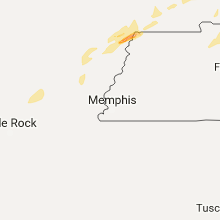
Hail Map for Saturday, December 17, 2016

Number of Impacted Households on 12/17/2016
0
Impacted by 1" or Larger Hail
0
Impacted by 1.75" or Larger Hail
0
Impacted by 2.5" or Larger Hail
Square Miles of Populated Area Impacted on 12/17/2016
0
Impacted by 1" or Larger Hail
0
Impacted by 1.75" or Larger Hail
0
Impacted by 2.5" or Larger Hail


Cities Most Affected by Hail Storms of 12/17/2016
| Hail Size | Demographics of Zip Codes Affected | ||||||
|---|---|---|---|---|---|---|---|
| City | Count | Average | Largest | Pop Density | House Value | Income | Age |
| Paducah, KY | 1 | 2.00 | 2.00 | 391 | $94k | $37.7k | 42.2 |
Hail and Wind Damage Spotted on 12/17/2016
Filter by Report Type:Hail ReportsWind Reports
Alabama
| Local Time | Report Details |
|---|---|
| 11:39 AM CST | Multiple trees and power lines down in the riverton area. time estimated from rada in colbert county AL, 23.6 miles WNW of Florence, AL |
| 11:38 PM CST | Trees down in riverton. time corrected based on rada in colbert county AL, 22 miles W of Florence, AL |
| 11:38 PM CST | Trees down on power lines. time estimated from radar. time correcte in lauderdale county AL, 21.7 miles NW of Florence, AL |
| 11:39 PM CST | Multiple trees and power lines down in the riverton area. time estimated from radar. time correcte in colbert county AL, 23.6 miles WNW of Florence, AL |
| 11:43 PM CST | Trees down on power lines. time estimated from rada in lauderdale county AL, 21.7 miles NW of Florence, AL |
| 11:45 PM CST | Power poles broken for a half-mile along county road 189 north of county road 14. time estimated from rada in lauderdale county AL, 12.1 miles WNW of Florence, AL |
| 12:00 AM CST | Trees down along county road 15. corrected time based on rada in lauderdale county AL, 10 miles NW of Florence, AL |
| 12:01 AM CST | Trees down in riverto in colbert county AL, 22 miles W of Florence, AL |
| 12:05 AM CST | Downed power pol in lauderdale county AL, 10.7 miles NW of Florence, AL |
| 12:06 AM CST | Trees down near the intersection of county road 189 and county road in lauderdale county AL, 12.7 miles WNW of Florence, AL |
| 12:29 AM CST | Trees down along county road 1 in lauderdale county AL, 10 miles NW of Florence, AL |
| 12:48 AM CST | Trees down in power lines in colbert heights area. time estimated from rada in colbert county AL, 10.4 miles S of Florence, AL |
Tennessee
| Local Time | Report Details |
|---|---|
| 11:59 AM CST | Tree on highway 52 just east of macon county line. car ran into tree on roadwa in clay county TN, 69.3 miles ENE of Nashville, TN |
| 6:00 PM CST | Lots of limbs down... car port top torn off... lots of shingles ripped off... windows broken... and large trees uprooted. possible tornad in dyer county TN, 47.7 miles W of Mc Kenzie, TN |
| 6:20 PM CST | Trees... power lines and poles down over parts of dyer count in dyer county TN, 50 miles WSW of Mc Kenzie, TN |
| 7:00 PM CST | Multiple trees down in the ralston coummunity... near marti in weakley county TN, 23.8 miles NW of Mc Kenzie, TN |
| 7:10 PM CST | Multiple trees down in the bean switch community... near greenfiel in weakley county TN, 15.8 miles W of Mc Kenzie, TN |
| 7:23 PM CST | Multiple power flashes... trees and power lies dow in henry county TN, 12.2 miles ENE of Mc Kenzie, TN |
| 8:07 PM CST | Tree reportedly blown down in northern houston county in houston county TN, 48 miles ENE of Mc Kenzie, TN |
| 8:09 PM CST | Tree reportedly blown down in stewart county. estimated locatio in stewart county TN, 50.3 miles WNW of Nashville, TN |
| 8:25 PM CST | Power line blown down on proctor ct at proctor dr in montgomery county TN, 37.9 miles NW of Nashville, TN |
| 8:30 PM CST | Three large trees dow in shelby county TN, 13.9 miles NNE of Memphis, TN |
| 11:15 PM CST | A tree was blown down on a car with occupants inside on saundersville rd. power lines down as wel in davidson county TN, 9.6 miles NE of Nashville, TN |
| 11:49 PM CST | Small barn blown in the road and a large barn had a tin removed from the roof. in the pleasant shade community on sloan branch roa in smith county TN, 46.1 miles ENE of Nashville, TN |
| 11:59 PM CST | Tree on highway 52 just east of macon county line. car ran into tree on roadwa in clay county TN, 69.3 miles ENE of Nashville, TN |
| 12:10 AM CST | Powerlines down on grandaddy roa in lawrence county TN, 34.8 miles NNE of Florence, AL |
| 12:18 AM CST | Six inch diameter limbs down on long branch roa in lawrence county TN, 28.1 miles NNE of Florence, AL |
| 12:18 AM CST | Trees down along the 500 block of main street in lorett in lawrence county TN, 24.3 miles NE of Florence, AL |
| 12:18 AM CST | Trees down on power lines along mahr avenu in lawrence county TN, 42.9 miles NE of Florence, AL |
| 12:36 AM CST | Tree through the roof at cherry creek apartments. 2 people displace in clay county TN, 76 miles ENE of Nashville, TN |
| 12:48 AM CST | Trees down blocking road on hillham highway near flat creek bridge. also report of roof damage in the same area due to trees dow in overton county TN, 79.1 miles ENE of Nashville, TN |
| 12:51 AM CST | Trees down on 41a and pinkston road in bedford county TN, 46.7 miles SSE of Nashville, TN |
| 12:54 AM CST | Quarter sized hail reported near Byrdstown, TN, 79.5 miles WNW of Knoxville, TN, quarter size hail on obey river bridge in byrdstown. |
Kentucky
| Local Time | Report Details |
|---|---|
| 3:05 PM CST | Hen Egg sized hail reported near Paducah, KY, 51.5 miles ESE of Cape Girardeau, MO |
| 3:07 PM CST | Quarter sized hail reported near Paducah, KY, 51.5 miles ESE of Cape Girardeau, MO, quarter size hail reported |
| 11:00 PM CST | Roof blown off building on downtown square in columbia... with power lines down in the area. adair co ky mesonet site showed peak gust of 42 mph at that time. in adair county KY, 65.2 miles SSE of Louisville, KY |
Missouri
| Local Time | Report Details |
|---|---|
| 4:30 PM CST | Tree damage reported near kennett. possible tornado damag in dunklin county MO, 75.2 miles N of Memphis, TN |
| 5:30 PM CST | 18 wheeler overturne in pemiscot county MO, 64.4 miles W of Mc Kenzie, TN |
Arkansas
| Local Time | Report Details |
|---|---|
| 6:02 PM CST | Trained spotter reports winds estimated 55-60 mp in mississippi county AR, 38.1 miles N of Memphis, TN |
| 7:59 PM CST | Quarter sized hail reported near Pine Bluff, AR, 40.2 miles SSE of Little Rock, AR |
Mississippi
| Local Time | Report Details |
|---|---|
| 8:50 PM CST | Power poles down... power out all along mcingvale r in desoto county MS, 23.2 miles S of Memphis, TN |
| 8:50 PM CST | Power poles down at hwy 61 and bowdry. cars with windows blown out near kirby estate in tunica county MS, 25.8 miles SSW of Memphis, TN |
| 9:20 PM CST | 18 wheeler blown over on i-55 in the senatobia area. time estimate in tate county MS, 36.8 miles S of Memphis, TN |
| 9:50 PM CST | 5 or 6 powerpoles completely snapped near the intersection highways 51 and 3 in panola county MS, 56.8 miles S of Memphis, TN |
| 10:25 PM CST | Downed power lines on the west side of oxford... in front of goose creek tennis club. possible tornado. time is radar estimate in lafayette county MS, 60.6 miles SSE of Memphis, TN |
| 11:15 PM CST | Trees snapped or uproote in yalobusha county MS, 61.2 miles NW of Starkville, MS |
| 11:15 PM CST | Storm damage reported in yalobusha county MS, 58.9 miles NW of Starkville, MS |
| 11:30 PM CST | Roof blown off a building and into a road. time is radar estimated. possible tornado damag in prentiss county MS, 51.8 miles W of Florence, AL |
| 11:45 PM CST | Emergency manager reports at least three buildings are a total loss near vardaman mississipp in calhoun county MS, 39.1 miles NW of Starkville, MS |
| 12:00 AM CST | Trees down on car near highway 9 and cherry cree in pontotoc county MS, 55.2 miles NNW of Starkville, MS |
| 12:30 AM CST | Large tree on house in woodland. time is radar estimate in chickasaw county MS, 25.6 miles NNW of Starkville, MS |
| 12:35 AM CST | Multiple trees down on van buren road and 36 in itawamba county MS, 55.9 miles NNE of Starkville, MS |
| 12:45 AM CST | Large tree down on house in woodland. time is radar estimate in chickasaw county MS, 25.6 miles NNW of Starkville, MS |
Louisiana
| Local Time | Report Details |
|---|---|
| 11:05 PM CST | Report of roof damage to a home in mer roug in morehouse county LA, 7.3 miles E of Bastrop, LA |
Connect with Interactive Hail Maps