

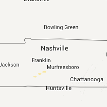
Hail Map for Wednesday, February 1, 2012

Number of Impacted Households on 2/1/2012
0
Impacted by 1" or Larger Hail
0
Impacted by 1.75" or Larger Hail
0
Impacted by 2.5" or Larger Hail
Square Miles of Populated Area Impacted on 2/1/2012
0
Impacted by 1" or Larger Hail
0
Impacted by 1.75" or Larger Hail
0
Impacted by 2.5" or Larger Hail


Cities Most Affected by Hail Storms of 2/1/2012
| Hail Size | Demographics of Zip Codes Affected | ||||||
|---|---|---|---|---|---|---|---|
| City | Count | Average | Largest | Pop Density | House Value | Income | Age |
| Grapevine, AR | 1 | 1.75 | 1.75 | 12 | $68k | $27.5k | 39.3 |
| Stamps, AR | 1 | 1.75 | 1.75 | 23 | $35k | $24.9k | 41.6 |
| Hensley, AR | 1 | 1.75 | 1.75 | 86 | $90k | $44.8k | 40.0 |
Hail and Wind Damage Spotted on 2/1/2012
Filter by Report Type:Hail ReportsWind Reports
Oklahoma
| Local Time | Report Details |
|---|---|
| 2:26 PM UTC | Quarter sized hail reported near Ada, OK, 44.8 miles NW of Atoka, OK, reported by pontotoc county emergency management |
| 3:45 PM UTC | Quarter sized hail reported near McAlester, OK, 36.2 miles NNE of Atoka, OK, mostly nickels and smaller but a few as big as a quarter. relayed by kotv. - correct location from mcalester to haywood. |
| 3:45 PM UTC | Quarter sized hail reported near McAlester, OK, 42.7 miles NNE of Atoka, OK, mostly nickels and smaller but a few as big as a quarter. relayed by kotv. |
| 3:45 PM UTC | Quarter sized hail reported near McAlester, OK, 31.1 miles NNE of Atoka, OK, delayed media report. - corrected time. this is the same event as the hail report at haywood. |
| 4:50 PM UTC | Quarter sized hail reported near McAlester, OK, 31.1 miles NNE of Atoka, OK, delayed media report. |
| 7:40 PM UTC | Ping Pong Ball sized hail reported near Broken Bow, OK, 51.7 miles W of Nashville, AR, co op observer reports hail of all sizes with the largest being a little smaller than a golf ball |
Louisiana
| Local Time | Report Details |
|---|---|
| 6:30 PM UTC | Kplc relayed a public report of damage to 2 homes. one was on musselwhite rd 3 miles west of oberlin off of highway 26. the second was along highway 26. damage included in allen county LA, 54.8 miles WNW of Lafayette, LA |
| 6:30 PM UTC | Kplc relayed a public report of damage to a home at 8308 w hwy 26 rd. damage included a porch and shingles from the roof. time estimated by rada in allen county LA, 54.8 miles WNW of Lafayette, LA |
Arkansas
| Local Time | Report Details |
|---|---|
| 7:06 PM UTC | Quarter sized hail reported near Rover, AR, 65.1 miles ESE of Fort Smith, AR |
| 8:10 PM UTC | Quarter sized hail reported near Benton, AR, 27.4 miles W of Little Rock, AR, hail between the size of dimes and quarters are covering the ground on highway 9 between crows and paron. |
| 8:14 PM UTC | Quarter sized hail reported near Glenwood, AR, 31.4 miles NNE of Nashville, AR, hail ranging from dime sized to quarter sized are currently falling. |
| 8:24 PM UTC | Trees and powerlines are down in bismar in hot spring county AR, 46.5 miles NE of Nashville, AR |
| 8:41 PM UTC | Quarter sized hail reported near Hensley, AR, 13.9 miles S of Little Rock, AR |
| 8:43 PM UTC | Golf Ball sized hail reported near Stamps, AR, 49.8 miles SSE of Nashville, AR, broadcast media received a report from a traveler in lafayette county that encountered golf ball-sized hail...and could have possibly been bigger. |
| 8:45 PM UTC | Golf Ball sized hail reported near Hensley, AR, 13.9 miles S of Little Rock, AR |
| 8:50 PM UTC | Trees and powerlines are down in malver in hot spring county AR, 40.6 miles SW of Little Rock, AR |
| 8:54 PM UTC | Quarter sized hail reported near Malvern, AR, 40.2 miles SW of Little Rock, AR |
| 9:01 PM UTC | Quarter sized hail reported near Redfield, AR, 22 miles SSE of Little Rock, AR |
| 9:17 PM UTC | Quarter sized hail reported near Magnolia, AR, 56.6 miles SE of Nashville, AR, hail of different sizes falling...mostly marble with larger mixed in. |
| 9:19 PM UTC | Golf Ball sized hail reported near Grapevine, AR, 37.3 miles S of Little Rock, AR |
| 9:30 PM UTC | Several trees are down in the humnoke are in lonoke county AR, 32.7 miles ESE of Little Rock, AR |
| 9:30 PM UTC | Several trees were blown down along 46 sout in grant county AR, 41.9 miles SSW of Little Rock, AR |
| 9:38 PM UTC | Measured at the stuttgart airpor in prairie county AR, 40.7 miles ESE of Little Rock, AR |
| 9:38 PM UTC | Minor damage was reported to three hangers at the stuttgart municipal airport. power lines are also down along hwy 79 between stuttgart and ro in prairie county AR, 40.7 miles ESE of Little Rock, AR |
| 9:38 PM UTC | Ping Pong Ball sized hail reported near Stuttgart, AR, 40.7 miles ESE of Little Rock, AR |
| 9:40 PM UTC | Several trees are down in pine bluff on 5th and cherry. a few powerlines are also dow in jefferson county AR, 39.9 miles SSE of Little Rock, AR |
| 9:40 PM UTC | Several trees and powerlines are down on highway 79 between stuttgart and ul in arkansas county AR, 43.7 miles ESE of Little Rock, AR |
| 9:41 PM UTC | Quarter sized hail reported near Smackover, AR, 64.2 miles NW of Bastrop, LA, smackover police department reported quarter-sized hail on west side of the city of smackover. |
| 10:14 PM UTC | A couple of trees were downed in the de witt are in arkansas county AR, 62 miles ESE of Little Rock, AR |
| 10:14 PM UTC | Several trees and powerlines were downed south of de wit in arkansas county AR, 64.6 miles SE of Little Rock, AR |
| 10:37 PM UTC | A tree was downed along hwy 1 in watso in desha county AR, 82.9 miles SE of Little Rock, AR |
| 10:39 PM UTC | State police reported 70-75 mph wind gusts across central phillips count in phillips county AR, 64.3 miles SW of Memphis, TN |
Texas
| Local Time | Report Details |
|---|---|
| 7:55 PM UTC | Quarter sized hail reported near Queen City, TX, 51.8 miles SSW of Nashville, AR |
| 8:00 PM UTC | Quarter sized hail reported near Queen City, TX, 50.4 miles SSW of Nashville, AR |
Mississippi
| Local Time | Report Details |
|---|---|
| 10:44 PM UTC | A shed was destroyed. trees were also dow in coahoma county MS, 63.4 miles SSW of Memphis, TN |
| 10:50 PM UTC | A utility pole was downed along hwy 1 north of rosedale in bolivar county MS, 90.8 miles NE of Bastrop, LA |
| 11:00 PM UTC | Tree down on reno stree in coahoma county MS, 72.1 miles SSW of Memphis, TN |
| 11:05 PM UTC | Trees down in a mobile home par in coahoma county MS, 72.1 miles SSW of Memphis, TN |
| 11:05 PM UTC | Large trees down...reported by bolivar eoc in bolivar county MS, 95.8 miles SSW of Memphis, TN |
| 11:16 PM UTC | 2 homes with roof dmg and a outbuilding was blown away along drew-merigold r in sunflower county MS, 97.6 miles SSW of Memphis, TN |
| 11:16 PM UTC | 3 homes with roof dmg and a outbuilding was blown away along drew-merigold rd and jennings r in sunflower county MS, 97.6 miles SSW of Memphis, TN |
| 11:20 PM UTC | Trees down in dunde in tunica county MS, 49 miles SSW of Memphis, TN |
| 11:31 PM UTC | Quarter sized hail reported near Batesville, MS, 56.8 miles S of Memphis, TN |
| 11:35 PM UTC | Quarter sized hail reported near Batesville, MS, 58.2 miles S of Memphis, TN |
| 11:35 PM UTC | A few power lines and power poles down between minter city and schlate in leflore county MS, 88.8 miles WNW of Starkville, MS |
| 11:44 PM UTC | Quarter sized hail reported near Courtland, MS, 61.6 miles S of Memphis, TN |
| 11:57 PM UTC | Trees downed along ms highway 7 near the grenada county lin in carroll county MS, 73.5 miles W of Starkville, MS |
| 11:58 PM UTC | A few trees were blown down around the holcomb are in grenada county MS, 70.3 miles WNW of Starkville, MS |
| 12:03 AM UTC | A tree down across kay lan in leflore county MS, 76.7 miles W of Starkville, MS |
| 12:05 AM UTC | Trees downed along cr 106 near the grenada county line in carroll county MS, 62.4 miles WNW of Starkville, MS |
| 12:10 AM UTC | *** 1 fatal *** one fatality occurred when a pine tree fell on a atv/operato in carroll county MS, 60.9 miles W of Starkville, MS |
| 12:10 AM UTC | *** 1 fatal *** one fatality occurred when a pine tree fell on a atv/operator. this occurred along co rd 286...between co rds 93 and 9 in carroll county MS, 60.9 miles W of Starkville, MS |
| 12:22 AM UTC | Powerlines down from a 6-18 inch diameter tre in lafayette county MS, 66.3 miles SSE of Memphis, TN |
| 12:30 AM UTC | Powerlines down from large tree on county road 15 in lafayette county MS, 61.7 miles SSE of Memphis, TN |
| 12:50 AM UTC | A few trees were blown dow in webster county MS, 32.3 miles WNW of Starkville, MS |
| 1:09 AM UTC | A few trees were blown down across ne webster c in webster county MS, 22.9 miles NW of Starkville, MS |
| 1:10 AM UTC | Several trees down along highway 345 from 1 mile south of cherry creek north to include cherry cree in pontotoc county MS, 61.8 miles N of Starkville, MS |
| 1:46 AM UTC | Awning over the gas pumps damaged and blown off from gas station along hwy 145 north in aberdee in monroe county MS, 29.3 miles NNE of Starkville, MS |
| 1:46 AM UTC | Roof damage to a store along hwy 145 north in aberdee in monroe county MS, 29.3 miles NNE of Starkville, MS |
| 1:55 AM UTC | Several trees down across highway 25 south of becker in monroe county MS, 37.9 miles NNE of Starkville, MS |
| 2:05 AM UTC | Power lines down between athens and quinc in monroe county MS, 40.7 miles NE of Starkville, MS |
| 2:12 AM UTC | Damage to a mobile home and damage to outdoor storage buildings on sipsey-detroit road a mile and a half west of the alabama state borde in monroe county MS, 46.9 miles NE of Starkville, MS |
Connect with Interactive Hail Maps