

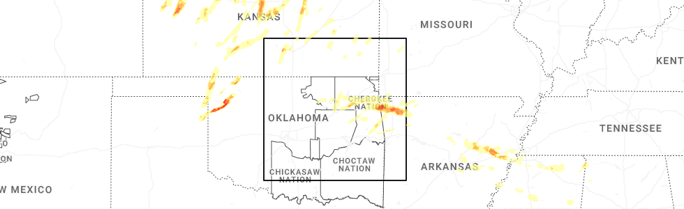
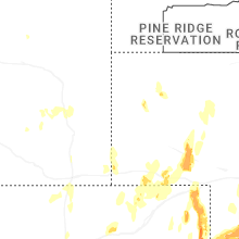
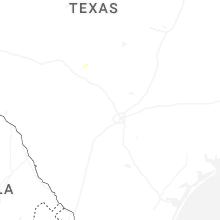
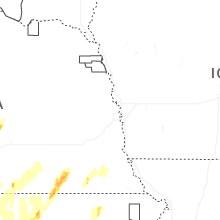
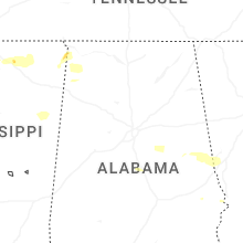
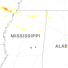
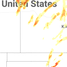
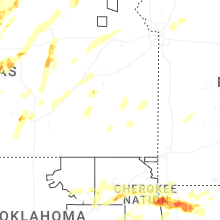
Hail Map for Sunday, May 18, 2025
Number of Impacted Households on 5/18/2025
0
Impacted by 1" or Larger Hail
0
Impacted by 1.75" or Larger Hail
0
Impacted by 2.5" or Larger Hail
Square Miles of Populated Area Impacted on 5/18/2025
0
Impacted by 1" or Larger Hail
0
Impacted by 1.75" or Larger Hail
0
Impacted by 2.5" or Larger Hail


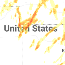

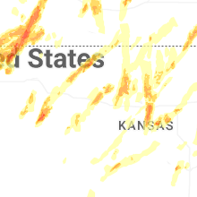

Cities Most Affected by Hail Storms of 5/18/2025
| Hail Size | Demographics of Zip Codes Affected | ||||||
|---|---|---|---|---|---|---|---|
| City | Count | Average | Largest | Pop Density | House Value | Income | Age |
| Arnett, OK | 10 | 3.43 | 5.00 | 1 | $30k | $28.2k | 45.5 |
| Fargo, OK | 5 | 2.91 | 3.06 | 2 | $51k | $31.0k | 43.0 |
| Freedom, OK | 5 | 1.85 | 2.00 | 1 | $45k | $32.6k | 47.0 |
| Saint Francis, KS | 5 | 1.85 | 2.00 | 2 | $50k | $31.4k | 51.1 |
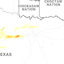
| Woodward, OK | 3 | 2.33 | 2.50 | 33 | $62k | $33.4k | 36.3 |
| Tuscola, TX | 3 | 2.17 | 2.50 | 31 | $76k | $46.7k | 41.0 |
| Scott City, KS | 2 | 2.88 | 4.00 | 6 | $72k | $40.5k | 41.5 |
| Benkelman, NE | 3 | 1.83 | 2.00 | 3 | $33k | $26.9k | 46.8 |
| Wichita, KS | 3 | 1.75 | 1.75 | 3924 | $78k | $40.2k | 35.7 |
| Laverne, OK | 2 | 2.38 | 2.75 | 1 | $40k | $34.0k | 40.0 |
| Shattuck, OK | 1 | 3.91 | 3.91 | 4 | $37k | $27.6k | 43.2 |
| Burlington, CO | 2 | 1.88 | 2.00 | 6 | $85k | $34.7k | 38.4 |
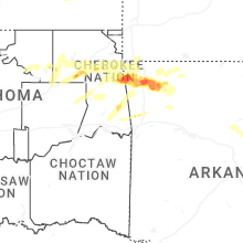
| Pryor, OK | 2 | 1.75 | 1.75 | 96 | $73k | $32.4k | 37.0 |
| Rosston, OK | 1 | 2.75 | 2.75 | 1 | $33k | $37.9k | 55.3 |
| Canadian, TX | 1 | 2.75 | 2.75 | 3 | $57k | $35.4k | 35.6 |
| Ranger, TX | 1 | 2.50 | 2.50 | 11 | $23k | $24.2k | 41.4 |
| Sidney, NE | 1 | 2.00 | 2.00 | 18 | $61k | $34.3k | 38.2 |
| Stratton, NE | 1 | 2.00 | 2.00 | 1 | $38k | $26.1k | 50.9 |
| Millsap, TX | 1 | 2.00 | 2.00 | 33 | $71k | $39.9k | 43.1 |
| Holyrood, KS | 1 | 2.00 | 2.00 | 4 | $25k | $31.5k | 50.3 |
| Strang, OK | 1 | 2.00 | 2.00 | 26 | $52k | $27.0k | 45.8 |
| Geneseo, KS | 1 | 1.75 | 1.75 | 3 | $26k | $26.5k | 51.4 |
| Wray, CO | 1 | 1.75 | 1.75 | 5 | $72k | $33.4k | 39.1 |
| Follett, TX | 1 | 1.75 | 1.75 | 1 | $44k | $31.1k | 42.5 |
| Springdale, AR | 1 | 1.75 | 1.75 | 893 | $86k | $34.2k | 28.8 |
| Wallace, NE | 1 | 1.75 | 1.75 | 1 | $55k | $36.5k | 42.3 |
| Salina, KS | 1 | 1.75 | 1.75 | 216 | $86k | $37.0k | 37.3 |
| Siloam Springs, AR | 1 | 1.75 | 1.75 | 180 | $85k | $35.9k | 31.1 |
| Santo, TX | 1 | 1.75 | 1.75 | 10 | $43k | $38.2k | 43.1 |
| Claremore, OK | 1 | 1.75 | 1.75 | 165 | $0k | $0.0k | 38.2 |
| Ellis, KS | 1 | 1.75 | 1.75 | 8 | $55k | $30.4k | 40.4 |
| Wakefield, KS | 1 | 1.75 | 1.75 | 10 | $70k | $35.0k | 38.7 |
Hail and Wind Damage Spotted on 5/18/2025
Filter by Report Type:Hail ReportsWind Reports
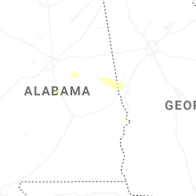
States Impacted
Alabama, Arkansas, Georgia, Mississippi, Oklahoma, Colorado, Kansas, Wyoming, Texas, NebraskaAlabama
| Local Time | Report Details |
|---|---|
| 7:00 AM CDT | Report of power lines down near the intersection of highway 28 and 4h roa in shelby county AL, 30.7 miles SE of Birmingham, AL |
| 7:01 AM CDT | Trees down blocking portions of cherokee street in sylacaug in talladega county AL, 39.6 miles SE of Birmingham, AL |
| 7:01 AM CDT | Trees down blocking a portion of 4th street in sylacaug in talladega county AL, 40 miles SE of Birmingham, AL |
| 7:02 AM CDT | Trees down blocking a portion of oldfield road in sylacaug in talladega county AL, 41.5 miles ESE of Birmingham, AL |
| 7:03 AM CDT | Trees and power lines fell onto a vehicl in talladega county AL, 40.5 miles SE of Birmingham, AL |
| 7:04 AM CDT | Trees down along main street in sycamor in talladega county AL, 40 miles ESE of Birmingham, AL |
| 7:23 AM CDT | Tree down blocking a portion of county road 5 between owens road and clay road near millerville in clay count in clay county AL, 47.9 miles NNW of Auburn, AL |
| 7:26 AM CDT | Tree down and power lines down blocking a portion of highway 63 near sandford roa in tallapoosa county AL, 40.7 miles NW of Auburn, AL |
| 7:37 AM CDT | Tree down along county road 7 in clay county AL, 39 miles NNW of Auburn, AL |
| 7:38 AM CDT | Tree down blocking hamlet mill road in horseshoe bend national par in tallapoosa county AL, 30.3 miles NNW of Auburn, AL |
| 7:40 AM CDT | Corrects previous tstm wnd dmg report from 1 nne horseshoe bend nmp. tree down blocking hamlet mill road in horseshoe bend national par in tallapoosa county AL, 30.3 miles NNW of Auburn, AL |
| 7:40 AM CDT | Tree down blocking germanys ferry road near county road 79. power lines affected by downed tre in tallapoosa county AL, 30.5 miles NNW of Auburn, AL |
| 7:43 AM CDT | Tree down blocking both lanes of county road 329 near county road 12 in randolph county AL, 52.7 miles N of Auburn, AL |
| 7:45 AM CDT | Report of 6 to 8 trees down near the intersection of county road 1 and lane branch roa in randolph county AL, 45.2 miles N of Auburn, AL |
| 7:50 AM CDT | Tree down along highway 431... blocking all lanes of traffi in randolph county AL, 42.3 miles N of Auburn, AL |
| 7:51 AM CDT | Tree down blocking both lanes along county road 5 in randolph county AL, 52.1 miles N of Auburn, AL |
| 7:56 AM CDT | Tree down blocking a portion of louina road... possible motor vehicle accident at this locatio in randolph county AL, 36.1 miles N of Auburn, AL |
| 7:57 AM CDT | Tree down along county road 87 blocking both lane in randolph county AL, 44 miles NNE of Auburn, AL |
| 7:58 AM CDT | Tree fell onto a power line and has caught on fir in randolph county AL, 49.4 miles NNE of Auburn, AL |
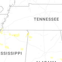
Arkansas
| Local Time | Report Details |
|---|---|
| 8:02 AM CDT | Metal roofing panels were removed from an outbuildin in lincoln county AR, 62.4 miles SE of Little Rock, AR |
| 1:05 PM CDT | Ping Pong Ball sized hail reported near Mountainburg, AR, 19.5 miles NNE of Fort Smith, AR, public report relayed by media. timing estimated by radar. |
| 3:58 PM CDT | Half Dollar sized hail reported near Siloam Springs, AR, 55.9 miles N of Fort Smith, AR, picture from social media. |
| 4:00 PM CDT | Quarter sized hail reported near Siloam Springs, AR, 55.4 miles N of Fort Smith, AR, significant quantities of accumulating hail... larger stones estimated to be at least 1 inch diameter. |
| 4:00 PM CDT | Social media photos depicting multiple large trees blown down and snapped in hal in benton county AR, 55.2 miles N of Fort Smith, AR |
| 4:04 PM CDT | Golf Ball sized hail reported near Siloam Springs, AR, 55.9 miles N of Fort Smith, AR |
| 4:05 PM CDT | Quarter sized hail reported near Siloam Springs, AR, 55.1 miles N of Fort Smith, AR, report from mping: quarter (1.00 in.). |
| 4:06 PM CDT | Quarter sized hail reported near Siloam Springs, AR, 57.9 miles N of Fort Smith, AR, report from mping: quarter (1.00 in.). |
| 4:10 PM CDT | 68 mph wind gust measured at kxn in benton county AR, 62.1 miles N of Fort Smith, AR |
| 4:16 PM CDT | Tree down across us 412 at the illinois river. viewed from ardot camer in benton county AR, 54.2 miles N of Fort Smith, AR |
| 4:20 PM CDT | Quarter sized hail reported near Fayetteville, AR, 50.3 miles N of Fort Smith, AR |
| 4:23 PM CDT | Tree snapped. large limbs broke in benton county AR, 59.8 miles N of Fort Smith, AR |
| 4:25 PM CDT | Multiple trees snapped or blown over. hail of 1 inch or greater also observe in washington county AR, 56.8 miles N of Fort Smith, AR |
| 4:25 PM CDT | Quarter sized hail reported near Springdale, AR, 53.3 miles NNE of Fort Smith, AR, report from mping: quarter (1.00 in.). |
| 4:30 PM CDT | Quarter sized hail reported near Springdale, AR, 56.4 miles NNE of Fort Smith, AR, report from mping: quarter (1.00 in.). |
| 4:33 PM CDT | Quarter sized hail reported near Springdale, AR, 56.6 miles NNE of Fort Smith, AR, report from mping: quarter (1.00 in.). |
| 4:33 PM CDT | Golf Ball sized hail reported near Springdale, AR, 57.2 miles NNE of Fort Smith, AR, report from mping: golf ball (1.75 in.). |
| 4:40 PM CDT | Half Dollar sized hail reported near Springdale, AR, 54.9 miles NNE of Fort Smith, AR, social media photo. |
| 4:40 PM CDT | Multiple photos of trees blown down or snapped in the are in washington county AR, 56 miles NNE of Fort Smith, AR |
| 9:20 PM CDT | Numerous trees down south side of forrest city. several power poles down. church sustained roof damage and a metal building sustained significant damag in st. francis county AR, 43.3 miles WSW of Memphis, TN |
| 9:25 PM CDT | Quarter sized hail reported near Forrest City, AR, 42.5 miles WSW of Memphis, TN |
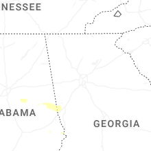
Georgia
| Local Time | Report Details |
|---|---|
| 9:15 AM EDT | Tree fell through home doing substantial damage along 100 block of colonia court in lagrang in troup county GA, 34.1 miles NE of Auburn, AL |
| 9:30 AM EDT | Numerous trees (6-10) snapped near mm 30 on i-8 in troup county GA, 48.2 miles SW of Atlanta, GA |
| 9:30 AM EDT | Numerous reports of trees and electrical wires down across the county per em in troup county GA, 39.7 miles NE of Auburn, AL |
| 9:50 AM EDT | Multiple trees down in city of warm springs - 2 blocking judson bulloch rd... one blocking hidden lakes rd... one over river rd... one on spring stree in meriwether county GA, 50.6 miles ENE of Auburn, AL |
| 9:50 AM EDT | Several trees down in city of manchester. truett st and one over the railroad near river roa in meriwether county GA, 53.1 miles ENE of Auburn, AL |
| 9:50 AM EDT | Tree down near intersection of amber wood lane and ga 8 in meriwether county GA, 54.7 miles ENE of Auburn, AL |
| 10:00 AM EDT | Report of several trees down along both east and west bound hwy 109 in southern pike count in pike county GA, 50.2 miles S of Atlanta, GA |
| 10:00 AM EDT | Numerous trees down and power outages across county per em in talbot county GA, 55.1 miles E of Auburn, AL |
| 10:00 AM EDT | Power lines down w/ fire along thompson rd in upson count in upson county GA, 53 miles S of Atlanta, GA |
| 10:05 AM EDT | Power poles and lines down along carter loop in city of thomasto in upson county GA, 61.3 miles S of Atlanta, GA |
| 10:05 AM EDT | Power lines down near intersection of gordon school and indian trail r in upson county GA, 62 miles S of Atlanta, GA |
| 10:49 AM EDT | Mesonet station ga347 i-75 at sr in houston county GA, 84.5 miles NW of Douglas, GA |
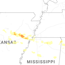
Mississippi
| Local Time | Report Details |
|---|---|
| 8:15 AM CDT | Lowndes ema reports numerous trees and power lines down with some trees on house in lowndes county MS, 27.9 miles E of Starkville, MS |
| 8:46 AM CDT | Trees down on morrow road near ms highway 35. time is radar estimate in panola county MS, 61.5 miles S of Memphis, TN |
| 8:56 AM CDT | Several power poles down on new africa road. time is radar estimate in coahoma county MS, 77.4 miles SSW of Memphis, TN |
| 9:40 AM CDT | Multiple trees down on main street in downtown charleston... ms. time is radar estimate in tallahatchie county MS, 78.6 miles S of Memphis, TN |
| 10:00 AM CDT | 2 trees blew over highway 51 around taylor auction and north of highway in grenada county MS, 66.2 miles WNW of Starkville, MS |
| 11:00 AM CDT | 1 tree down across natchez trace parkway just north of highway 4 in clay county MS, 22.1 miles NW of Starkville, MS |
| 10:09 PM CDT | Multiple trees down on wilson ridg in desoto county MS, 19.5 miles SSW of Memphis, TN |
| 10:23 PM CDT | Trees down in yard on just off of tara driv in desoto county MS, 20.9 miles S of Memphis, TN |
| 10:34 PM CDT | Large tree across pleasant hill rd near laughter r in desoto county MS, 19.8 miles SSE of Memphis, TN |
| 11:50 PM CDT | Corrects previous tstm wnd dmg report from 1 ene paden. trees down on cr 151. roof blown off a house on cr 15 in tishomingo county MS, 33.9 miles WSW of Florence, AL |
| 12:15 AM CDT | Trees down in the oldham communit in tishomingo county MS, 25.9 miles W of Florence, AL |
| 1:00 AM CDT | Trees down on cr 15 in tishomingo county MS, 33.9 miles WSW of Florence, AL |
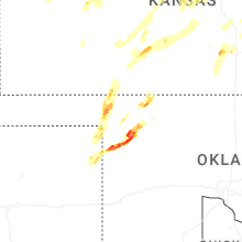
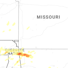
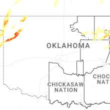
Oklahoma
| Local Time | Report Details |
|---|---|
| 12:20 PM CDT | Quarter sized hail reported near Stilwell, OK, 31.4 miles NNW of Fort Smith, AR |
| 12:46 PM CDT | Half Dollar sized hail reported near Skiatook, OK, 17 miles NNW of Tulsa, OK |
| 12:47 PM CDT | Quarter sized hail reported near Skiatook, OK, 16.2 miles N of Tulsa, OK, report from mping: quarter (1.00 in.). |
| 12:54 PM CDT | Quarter sized hail reported near Collinsville, OK, 15.7 miles NNE of Tulsa, OK, report from mping: quarter (1.00 in.). |
| 1:36 PM CDT | Golf Ball sized hail reported near Claremore, OK, 25.2 miles ENE of Tulsa, OK, rogers county em reports golf ball sized hail in tiawah near hwy 530 and 88. |
| 1:41 PM CDT | Half Dollar sized hail reported near Claremore, OK, 32.8 miles ENE of Tulsa, OK, intersection of s 4230 and hwy 20 on mayes and rogers county line. |
| 1:43 PM CDT | Golf Ball sized hail reported near Pryor, OK, 33.5 miles ENE of Tulsa, OK |
| 1:46 PM CDT | Quarter sized hail reported near Pryor, OK, 36 miles ENE of Tulsa, OK, mayes county em reports 1 inch hail near hwy 20 and 428 rd. time approximated. |
| 2:00 PM CDT | Golf Ball sized hail reported near Pryor, OK, 40.1 miles ENE of Tulsa, OK, timing and location approximated. |
| 2:29 PM CDT | Hen Egg sized hail reported near Strang, OK, 51.5 miles ENE of Tulsa, OK, timing and location approximated. |
| 3:30 PM CDT | Trees down on daytown rd in kansas... ok. timing approximated by rada in delaware county OK, 61.2 miles NNW of Fort Smith, AR |
| 3:35 PM CDT | Quarter sized hail reported near Kansas, OK, 61.2 miles NNW of Fort Smith, AR |
| 3:50 PM CDT | Several very large branches broken. a few trees blown over at natural falls state par in delaware county OK, 55.9 miles NNW of Fort Smith, AR |
| 5:35 PM CDT | Baseball sized hail reported near Rosston, OK, 39.3 miles NW of Woodward, OK, delayed report. relayed by emergency management. time is estimated from radar. |
| 5:35 PM CDT | Half Dollar sized hail reported near Arnett, OK, 29.9 miles SW of Woodward, OK, report from mping: half dollar (1.25 in.). |
| 5:35 PM CDT | Quarter sized hail reported near Laverne, OK, 34.9 miles NW of Woodward, OK, report from mping: quarter (1.00 in.). |
| 5:36 PM CDT | Quarter sized hail reported near Arnett, OK, 27.4 miles SW of Woodward, OK |
| 5:39 PM CDT | Hen Egg sized hail reported near Laverne, OK, 33.8 miles NW of Woodward, OK, nwschat report. |
| 5:40 PM CDT | Ping Pong Ball sized hail reported near Gate, OK, 43.8 miles NW of Woodward, OK, report from mping: ping pong ball (1.50 in.). |
| 5:40 PM CDT | Storm damage reported in ellis county OK, 36.7 miles SW of Woodward, OK |
| 5:43 PM CDT | Tea Cup sized hail reported near Arnett, OK, 31 miles SW of Woodward, OK, report from mping: tea cup (3.00 in.). |
| 5:45 PM CDT | Tea Cup sized hail reported near Arnett, OK, 28.6 miles SW of Woodward, OK, report from mping: baseball++ (3.50 in.). |
| 5:45 PM CDT | Grapefruit sized hail reported near Arnett, OK, 31 miles SW of Woodward, OK, delayed report. report from mping: grapefruit+ (4.25 in.). time adjusted based on radar. |
| 5:47 PM CDT | Baseball sized hail reported near Laverne, OK, 37.7 miles NW of Woodward, OK, report from mping: baseball (2.75 in.). |
| 5:48 PM CDT | Tea Cup sized hail reported near Shattuck, OK, 33.6 miles SW of Woodward, OK |
| 5:55 PM CDT | Golf Ball sized hail reported near Arnett, OK, 24.3 miles SSW of Woodward, OK, report from mping: golf ball (1.75 in.). |
| 5:59 PM CDT | Hen Egg sized hail reported near Arnett, OK, 27 miles SW of Woodward, OK, photo transmitted through nwschat. |
| 6:02 PM CDT | Softball sized hail reported near Arnett, OK, 25.3 miles SW of Woodward, OK, twitter photo... time is radar estimate. |
| 6:02 PM CDT | Softball sized hail reported near Arnett, OK, 25.3 miles SW of Woodward, OK, corrects previous hail report from 4 ene arnett. twitter photo... time is radar estimate. updated with a ruler measurement. |
| 6:02 PM CDT | Ping Pong Ball sized hail reported near Arnett, OK, 24.9 miles SW of Woodward, OK, report from mping: ping pong ball (1.50 in.)... time is radar estimate. |
| 6:08 PM CDT | Hen Egg sized hail reported near Arnett, OK, 24.2 miles SW of Woodward, OK, report from mping: hen egg+ (2.25 in.). |
| 6:11 PM CDT | Grapefruit sized hail reported near Arnett, OK, 21.7 miles SSW of Woodward, OK, delayed report. report from mping: grapefruit (4.00 in.). |
| 6:15 PM CDT | Grapefruit sized hail reported near Arnett, OK, 28.1 miles SW of Woodward, OK, x post with photo. |
| 6:18 PM CDT | Tea Cup sized hail reported near Fargo, OK, 16.7 miles SW of Woodward, OK, photo on x with calipers. time is radar estimate. |
| 6:28 PM CDT | Baseball sized hail reported near Fargo, OK, 15 miles SW of Woodward, OK, report from mping: baseball (2.75 in.). |
| 6:32 PM CDT | Tea Cup sized hail reported near Fargo, OK, 16.7 miles SW of Woodward, OK, report from mping: tea cup (3.00 in.). |
| 6:42 PM CDT | Quarter sized hail reported near Woodward, OK, 5.5 miles SSE of Woodward, OK, delayed report. report from mping: quarter (1.00 in.). |
| 6:42 PM CDT | Baseball sized hail reported near Fargo, OK, 14.3 miles SW of Woodward, OK, report from mping: baseball (2.75 in.). |
| 6:45 PM CDT | Tea Cup sized hail reported near Fargo, OK, 12 miles SW of Woodward, OK, x post with photo. |
| 6:56 PM CDT | Ping Pong Ball sized hail reported near Woodward, OK, 0.7 miles WSW of Woodward, OK |
| 6:56 PM CDT | Hen Egg sized hail reported near Woodward, OK, 2.4 miles SSE of Woodward, OK, nwschat photo. |
| 6:57 PM CDT | Tennis Ball sized hail reported near Woodward, OK, 4.1 miles SSW of Woodward, OK, report from mping: tennis ball (2.50 in.). |
| 6:59 PM CDT | Tennis Ball sized hail reported near Woodward, OK, 1.1 miles SSE of Woodward, OK, nwschat photo. |
| 7:02 PM CDT | Quarter sized hail reported near Woodward, OK, 4.1 miles SE of Woodward, OK, delayed report. report from mping: quarter (1.00 in.). |
| 7:09 PM CDT | Quarter sized hail reported near Fort Supply, OK, 13.4 miles NW of Woodward, OK, report from mping: quarter (1.00 in.). |
| 7:22 PM CDT | Ping Pong Ball sized hail reported near Woodward, OK, 3.3 miles ENE of Woodward, OK, hail along 34c & county road 38. |
| 7:39 PM CDT | Quarter sized hail reported near Mooreland, OK, 16.3 miles NE of Woodward, OK |
| 7:41 PM CDT | Golf Ball sized hail reported near Freedom, OK, 17.8 miles NE of Woodward, OK, time is radar estimate. |
| 8:14 PM CDT | Quarter sized hail reported near Freedom, OK, 29.9 miles NNE of Woodward, OK, report from mping: quarter (1.00 in.). |
| 8:16 PM CDT | Golf Ball sized hail reported near Freedom, OK, 29.9 miles NNE of Woodward, OK, report from mping: golf ball (1.75 in.). |
| 8:17 PM CDT | Golf Ball sized hail reported near Freedom, OK, 26.2 miles NNE of Woodward, OK, nwschat report. |
| 8:18 PM CDT | Hen Egg sized hail reported near Freedom, OK, 30.8 miles NNE of Woodward, OK, report from mping: hen egg (2.00 in.). |
| 8:22 PM CDT | Hen Egg sized hail reported near Freedom, OK, 29.4 miles NNE of Woodward, OK, nwschat with photo. |
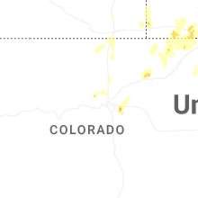
Colorado
| Local Time | Report Details |
|---|---|
| 1:11 PM MDT | Half Dollar sized hail reported near Aurora, CO, 20 miles ESE of Denver, CO, report from mping: half dollar (1.25 in.). |
| 1:23 PM MDT | Storm damage reported in arapahoe county CO, 23.7 miles ESE of Denver, CO |
| 1:25 PM MDT | Ping Pong Ball sized hail reported near Aurora, CO, 20 miles ESE of Denver, CO, report from mping: ping pong ball (1.50 in.). |
| 1:56 PM MDT | Storm damage reported in adams county CO, 32 miles E of Denver, CO |
| 2:46 PM MDT | Storm damage reported in morgan county CO, 58.2 miles NE of Denver, CO |
| 2:51 PM MDT | Storm damage reported in morgan county CO, 63.7 miles W of Yuma, CO |
| 3:16 PM MDT | Quarter sized hail reported near Boulder, CO, 21.8 miles NW of Denver, CO, picture of 1 inch hail on x. |
| 3:32 PM MDT | Half Dollar sized hail reported near Burlington, CO, 58.3 miles W of Colby, KS, report from mping: half dollar (1.25 inch). |
| 3:36 PM MDT | Storm damage reported in weld county CO, 72.5 miles SSW of Scottsbluff, NE |
| 3:40 PM MDT | Golf Ball sized hail reported near Burlington, CO, 59.4 miles SSE of Yuma, CO, social media report of hail up to golf ball in size with pictures. |
| 3:51 PM MDT | Half Dollar sized hail reported near Burlington, CO, 61.4 miles SSE of Yuma, CO, social media report with video of hail quarter to half dollar in size. |
| 3:55 PM MDT | Awos station k1ow 2 nw pawnee butte in weld county CO, 70 miles SSW of Scottsbluff, NE |
| 4:04 PM MDT | Quarter sized hail reported near Wray, CO, 32.3 miles ESE of Yuma, CO, spotter reported quarter sized hail 7 miles se of wray at approximately 4:05 pm mdt (2205 utc). |
| 4:08 PM MDT | Golf Ball sized hail reported near Wray, CO, 27.6 miles ESE of Yuma, CO, observer reported hail ranging from nickel to golf ball in size. |
| 4:15 PM MDT | Pws-kcowray in yuma county CO, 24.4 miles ESE of Yuma, CO |
| 4:15 PM MDT | Hen Egg sized hail reported near Burlington, CO, 54.1 miles SSE of Yuma, CO, storm chaser reported hen egg sized hail ~11 miles nne of burlington at approximately 4:15 pm mdt (2215 utc). location roughly 3 to 4 miles east of highway 385. |
| 4:17 PM MDT | Quarter sized hail reported near Wray, CO, 26.3 miles E of Yuma, CO, social media report of quarter sized hail. |
| 4:38 PM MDT | Quarter sized hail reported near Iliff, CO, 47.9 miles NNW of Yuma, CO, half inch to one hail hail covering the ground. |
| 4:53 PM MDT | Storm damage reported in phillips county CO, 43.7 miles N of Yuma, CO |
| 5:03 PM MDT | Storm damage reported in sedgwick county CO, 51.2 miles NNE of Yuma, CO |
| 5:53 PM MDT | Asos station kitr burlington co airpor in kit carson county CO, 65.7 miles SSE of Yuma, CO |
| 6:09 PM MDT | Quarter sized hail reported near Wray, CO, 26.3 miles E of Yuma, CO, report of quarter sized hail in wray. |
| 6:12 PM MDT | Half Dollar sized hail reported near Wray, CO, 32.1 miles ESE of Yuma, CO, relayed report of hail up to half dollar in size. time estimated from radar. |
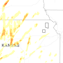
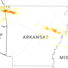
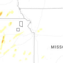
Kansas
| Local Time | Report Details |
|---|---|
| 2:59 PM CDT | Half Dollar sized hail reported near Garden Plain, KS, 16.8 miles W of Wichita, KS |
| 3:15 PM CDT | Ping Pong Ball sized hail reported near Colwich, KS, 12.9 miles WNW of Wichita, KS |
| 3:24 PM CDT | Half Dollar sized hail reported near Wichita, KS, 6.3 miles WSW of Wichita, KS, half dollar size hail at nws office. |
| 3:25 PM CDT | Golf Ball sized hail reported near Wichita, KS, 5.2 miles W of Wichita, KS, near kellogg and ridge. |
| 3:28 PM CDT | Golf Ball sized hail reported near Wichita, KS, 3.1 miles WNW of Wichita, KS, near 9th and zoo boulevard. |
| 3:29 PM CDT | Golf Ball sized hail reported near Wichita, KS, 3.4 miles WNW of Wichita, KS, near 13th and west... courtesy of kake tv. |
| 4:26 PM CDT | Ping Pong Ball sized hail reported near Hesston, KS, 32.4 miles N of Wichita, KS |
| 3:52 PM MDT | Half Dollar sized hail reported near Goodland, KS, 44.5 miles W of Colby, KS |
| 3:58 PM MDT | Asos station kgld goodland measured a 58 mph wind gust at 3:58 pm mdt (2158 utc). sustained at 40 mp in sherman county KS, 35.1 miles W of Colby, KS |
| 4:06 PM MDT | Asos station kgld goodland measured a 60 mph (52 knot) wind gust at 4:06 pm mdt (2206 utc). sustained at 38 mp in sherman county KS, 35.1 miles W of Colby, KS |
| 5:15 PM CDT | Quarter sized hail reported near Bushton, KS, 56.2 miles ESE of Hays, KS |
| 5:19 PM CDT | Hen Egg sized hail reported near Holyrood, KS, 53.5 miles ESE of Hays, KS |
| 5:27 PM CDT | Quarter sized hail reported near Ingalls, KS, 24.5 miles ESE of Garden City, KS, report from mping: quarter (1.00 in.). |
| 5:28 PM CDT | Quarter sized hail reported near Alton, KS, 38.6 miles NNE of Hays, KS, spotter reports quarter size hail south of alton. |
| 5:31 PM CDT | Golf Ball sized hail reported near Scott City, KS, 48.1 miles N of Garden City, KS |
| 5:33 PM CDT | Quarter sized hail reported near Saint Francis, KS, 47.8 miles WNW of Colby, KS, report from mping: quarter (1.00 in). |
| 5:34 PM CDT | Grapefruit sized hail reported near Scott City, KS, 48.1 miles N of Garden City, KS, photo sent in by emergency manager... public report. |
| 5:35 PM CDT | Half Dollar sized hail reported near Saint Francis, KS, 47.8 miles WNW of Colby, KS, report from mping: half dollar (1.25 in.). |
| 5:35 PM CDT | Hen Egg sized hail reported near Saint Francis, KS, 43 miles NW of Colby, KS, off duty nws employee reports hailstones still on the ground up to 2 inches in size. time estimated from radar. |
| 5:36 PM CDT | Golf Ball sized hail reported near Saint Francis, KS, 47.8 miles WNW of Colby, KS, report from mping: golf ball (1.75 in.). |
| 5:38 PM CDT | Ping Pong Ball sized hail reported near Geneseo, KS, 67.3 miles ESE of Hays, KS |
| 5:38 PM CDT | Ping Pong Ball sized hail reported near Saint Francis, KS, 47.8 miles WNW of Colby, KS, report from mping: ping pong ball (1.50 in.). |
| 5:38 PM CDT | Quarter sized hail reported near Alton, KS, 46.4 miles NNE of Hays, KS, spotter reports quarter sized hail in alton. |
| 5:39 PM CDT | Golf Ball sized hail reported near Geneseo, KS, 67.8 miles ESE of Hays, KS |
| 5:41 PM CDT | Golf Ball sized hail reported near Saint Francis, KS, 48.2 miles WNW of Colby, KS, spotter reports hail up to golf ball in northern portion of saint francis. |
| 5:45 PM CDT | Mesonet station up840 9.0 w winona (upr in logan county KS, 33.1 miles SW of Colby, KS |
| 5:50 PM CDT | Half Dollar sized hail reported near Sylvan Grove, KS, 51.9 miles ENE of Hays, KS |
| 5:52 PM CDT | Quarter sized hail reported near Cimarron, KS, 27.6 miles ESE of Garden City, KS |
| 5:55 PM CDT | Golf Ball sized hail reported near Saint Francis, KS, 45.9 miles WNW of Colby, KS, report from mping: golf ball (1.75 in.). |
| 5:57 PM CDT | Half Dollar sized hail reported near Marquette, KS, 72.1 miles NNW of Wichita, KS |
| 6:01 PM CDT | Quarter sized hail reported near Marquette, KS, 67.7 miles NNW of Wichita, KS, mping report. |
| 6:02 PM CDT | Hen Egg sized hail reported near Saint Francis, KS, 45.9 miles WNW of Colby, KS |
| 6:08 PM CDT | Approximately 15 rail cars blown over and power lines damaged. may be from a possible tornad in scott county KS, 37.6 miles NNW of Garden City, KS |
| 6:15 PM CDT | Quarter sized hail reported near Bird City, KS, 45.5 miles NW of Colby, KS, report of 1 inch hail north of bird city. |
| 6:16 PM CDT | Quarter sized hail reported near Scott City, KS, 45.7 miles SSE of Colby, KS, social media report (with video) of quarter sized hail near elkrader at 5:16 pm mdt. |
| 6:19 PM CDT | 3350_(awn644725c42c9e7c32b00d2cb6 in cheyenne county KS, 40.6 miles NNW of Colby, KS |
| 6:22 PM CDT | Quarter sized hail reported near Ramona, KS, 48.1 miles SW of Manhattan, KS |
| 6:31 PM CDT | Half Dollar sized hail reported near Bird City, KS, 44.7 miles NW of Colby, KS |
| 6:33 PM CDT | Quarter sized hail reported near Herington, KS, 40.9 miles SSW of Manhattan, KS |
| 6:35 PM CDT | Quarter sized hail reported near Oakley, KS, 26.4 miles SE of Colby, KS, storm spotter network report of one inch hail. |
| 6:42 PM CDT | Quarter sized hail reported near Herington, KS, 34.9 miles SW of Manhattan, KS |
| 6:43 PM CDT | Quarter sized hail reported near Salina, KS, 61.1 miles WSW of Manhattan, KS, received via mping. |
| 6:43 PM CDT | Ping Pong Ball sized hail reported near Chapman, KS, 33.2 miles SW of Manhattan, KS |
| 6:45 PM CDT | Golf Ball sized hail reported near Salina, KS, 60.5 miles WSW of Manhattan, KS, time and location estimated from radar. |
| 6:51 PM CDT | Ping Pong Ball sized hail reported near Beloit, KS, 77.2 miles ENE of Hays, KS, report on social media of ping pong ball size hail in beloit. |
| 6:51 PM CDT | Ping Pong Ball sized hail reported near Salina, KS, 63.3 miles WSW of Manhattan, KS |
| 6:52 PM CDT | Ping Pong Ball sized hail reported near Beloit, KS, 77.2 miles ENE of Hays, KS |
| 6:55 PM CDT | Quarter sized hail reported near Junction City, KS, 20.7 miles SW of Manhattan, KS |
| 7:05 PM CDT | Ping Pong Ball sized hail reported near Beloit, KS, 77.6 miles ENE of Hays, KS, report on social media of ping pong ball sized hail in beloit. |
| 7:05 PM CDT | Possible tornado. delayed report of damage to a building along road s 40w. time estimate in sheridan county KS, 31 miles ESE of Colby, KS |
| 7:06 PM CDT | Possible tornado. delayed report of powerlines down for a mile along w road 90 s. time estimate in sheridan county KS, 30.9 miles ESE of Colby, KS |
| 7:07 PM CDT | Quarter sized hail reported near Grinnell, KS, 33.1 miles SE of Colby, KS, chaser report of one inch hail on interstate 70. |
| 7:30 PM CDT | Half Dollar sized hail reported near Hoxie, KS, 33 miles E of Colby, KS, report of half dollar sized hail in hoxie. |
| 7:32 PM CDT | Quarter sized hail reported near Saint Francis, KS, 42 miles ESE of Yuma, CO, relayed report of quarter sized hail. |
| 7:34 PM CDT | Quarter sized hail reported near Beloit, KS, 77.5 miles WNW of Manhattan, KS, dime to quarter size hail. |
| 7:47 PM CDT | Quarter sized hail reported near Ogallah, KS, 23 miles WNW of Hays, KS |
| 7:55 PM CDT | Asos station kcnk concordi in cloud county KS, 63.7 miles WNW of Manhattan, KS |
| 7:57 PM CDT | Golf Ball sized hail reported near Ellis, KS, 15.6 miles NW of Hays, KS |
| 8:07 PM CDT | Quarter sized hail reported near Morland, KS, 51 miles E of Colby, KS |
| 8:11 PM CDT | Golf Ball sized hail reported near Wakefield, KS, 31.7 miles W of Manhattan, KS |
| 8:11 PM CDT | 1.5 to 2.5 inch diameter limbs dow in clay county KS, 31.7 miles W of Manhattan, KS |
| 10:55 PM CDT | Several powerlines down at this location. possible tornad in pratt county KS, 84.1 miles W of Wichita, KS |
| 11:05 PM CDT | Trees shredded and powerlines and poles snaped. tornado damage possibl in pratt county KS, 78.6 miles W of Wichita, KS |
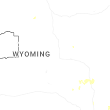
Wyoming
| Local Time | Report Details |
|---|---|
| 3:46 PM MDT | Quarter sized hail reported near Wheatland, WY, 62.3 miles NE of Laramie, WY |
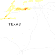
Texas
| Local Time | Report Details |
|---|---|
| 4:59 PM CDT | Golf Ball sized hail reported near Follett, TX, 41.9 miles W of Woodward, OK |
| 5:02 PM CDT | Hen Egg sized hail reported near Tuscola, TX, 16.8 miles SSW of Abilene, TX |
| 5:02 PM CDT | Hen Egg sized hail reported near Tuscola, TX, 16.2 miles SSW of Abilene, TX |
| 5:02 PM CDT | Tennis Ball sized hail reported near Tuscola, TX, 16.8 miles SSW of Abilene, TX |
| 5:14 PM CDT | Baseball sized hail reported near Canadian, TX, 48.5 miles SW of Woodward, OK, firefighter around 12 miles south of higgins reported baseball size hail. |
| 6:40 PM CDT | Quarter sized hail reported near Robert Lee, TX, 58.4 miles SW of Abilene, TX, public report of quarter size hail on office social media page. |
| 6:52 PM CDT | Quarter sized hail reported near Cisco, TX, 48.5 miles ENE of Abilene, TX, quarter sized hail in harpersville. |
| 7:16 PM CDT | Tennis Ball sized hail reported near Ranger, TX, 62.1 miles E of Abilene, TX, tennis ball sized hail in la casa. |
| 7:50 PM CDT | Half Dollar sized hail reported near Decatur, TX, 56 miles NW of Dallas, TX, report from mping: half dollar (1.25 in.). |
| 8:07 PM CDT | Quarter sized hail reported near Blackwell, TX, 44.2 miles WSW of Abilene, TX, report from mping: quarter (1.00 in.). |
| 8:24 PM CDT | Hen Egg sized hail reported near Millsap, TX, 73 miles W of Dallas, TX |
| 8:27 PM CDT | Quarter sized hail reported near Gordon, TX, 86.8 miles E of Abilene, TX, report from mping: quarter (1.00 in.). |
| 8:27 PM CDT | Golf Ball sized hail reported near Santo, TX, 79.4 miles W of Dallas, TX, golf ball sized hail near i-20 at mile marker 384. |
| 8:29 PM CDT | Quarter sized hail reported near Millsap, TX, 69.9 miles W of Dallas, TX, report from mping: quarter (1.00 in.). |
| 9:49 PM CDT | 67 mph gust measured at guinn hall tw in denton county TX, 36.7 miles NNW of Dallas, TX |
Nebraska
| Local Time | Report Details |
|---|---|
| 4:00 PM MDT | Quarter sized hail reported near Sidney, NE, 55.7 miles SSE of Scottsbluff, NE |
| 4:15 PM MDT | Storm damage reported in kimball county NE, 43.6 miles S of Scottsbluff, NE |
| 4:35 PM MDT | Quarter sized hail reported near Sidney, NE, 64.8 miles SE of Scottsbluff, NE |
| 4:35 PM MDT | Quarter sized hail reported near Sidney, NE, 63.2 miles SSE of Scottsbluff, NE, trained spotter reports quarter size hail. |
| 4:45 PM MDT | Hen Egg sized hail reported near Sidney, NE, 64.8 miles SE of Scottsbluff, NE, trained spotter reports 2 inch diame |
| 5:05 PM MDT | Storm damage reported in scotts bluff county NE, 0.6 miles NNE of Scottsbluff, NE |
| 5:06 PM MDT | Storm damage reported in scotts bluff county NE, 4 miles W of Scottsbluff, NE |
| 5:07 PM MDT | Quarter sized hail reported near Sidney, NE, 60.3 miles SE of Scottsbluff, NE |
| 5:16 PM MDT | Storm damage reported in scotts bluff county NE, 0.6 miles NNE of Scottsbluff, NE |
| 5:27 PM MDT | Quarter sized hail reported near Benkelman, NE, 55.1 miles E of Yuma, CO, report from mping: quarter (1.00 in.). |
| 5:28 PM MDT | Ping Pong Ball sized hail reported near Benkelman, NE, 51.9 miles NNW of Colby, KS, trained spotter reports hail up to one and a half an inch. |
| 5:28 PM MDT | Hen Egg sized hail reported near Benkelman, NE, 51.9 miles NNW of Colby, KS, trained spotter reports hail up to 2 inches with photos. |
| 5:32 PM MDT | Quarter sized hail reported near Benkelman, NE, 53.4 miles NW of Colby, KS, report from mping: quarter (1.00 in.). |
| 5:37 PM MDT | Ping Pong Ball sized hail reported near Benkelman, NE, 53.1 miles NW of Colby, KS, report from mping: ping pong ball (1.50 in.). |
| 5:38 PM MDT | Golf Ball sized hail reported near Benkelman, NE, 53.1 miles NW of Colby, KS, report from mping: golf ball (1.75 in.). |
| 5:39 PM MDT | Storm damage reported in garden county NE, 76.6 miles SE of Scottsbluff, NE |
| 5:47 PM MDT | Golf Ball sized hail reported near Benkelman, NE, 53.1 miles NNW of Colby, KS, report of golf ball sized hail just west of max... ne. |
| 6:59 PM CDT | Weak tornado crossed hwy 34 roughly here; downed power lines and tipped over pivot in hitchcock county NE, 52.4 miles NNW of Colby, KS |
| 6:00 PM MDT | Sheet metal in ditch... power poles down.. in dundy county NE, 53 miles NNW of Colby, KS |
| 7:03 PM CDT | Hen Egg sized hail reported near Stratton, NE, 56.7 miles NNW of Colby, KS, caller reported two inch hail along with broad rotation. |
| 7:07 PM CDT | Quarter sized hail reported near Lexington, NE, 65.6 miles ESE of North Platte, NE, spotter reports quarter sized hail west-southwest of overton. |
| 7:16 PM CDT | Roof damage to home at in stratton at mm 5 in hitchcock county NE, 52.9 miles N of Colby, KS |
| 7:35 PM CDT | Quarter sized hail reported near Cozad, NE, 52.6 miles ESE of North Platte, NE, spotter reports quarter sized hail near darr. |
| 7:49 PM CDT | Quarter sized hail reported near Gibbon, NE, 30.6 miles WSW of Grand Island, NE |
| 7:55 PM CDT | Quarter sized hail reported near Ravenna, NE, 26.7 miles W of Grand Island, NE, spotter reports quarter sized hail. |
| 7:59 PM CDT | Golf Ball sized hail reported near Wallace, NE, 36 miles SSW of North Platte, NE, report from mping. |
| 8:00 PM CDT | Storm damage reported in hayes county NE, 42.8 miles SSW of North Platte, NE |
| 7:16 PM MDT | Quarter sized hail reported near Benkelman, NE, 54.6 miles NW of Colby, KS, report from mping: quarter (1.00 in.). |
| 8:20 PM CDT | Storm damage reported in buffalo county NE, 23.8 miles WNW of Grand Island, NE |
| 8:48 PM CDT | Quarter sized hail reported near North Platte, NE, 2.5 miles W of North Platte, NE |
| 9:32 PM CDT | Storm damage reported in nuckolls county NE, 49.7 miles SSE of Grand Island, NE |
| 9:33 PM CDT | Storm damage reported in nuckolls county NE, 46 miles SSE of Grand Island, NE |
| 9:38 PM CDT | Quarter sized hail reported near North Platte, NE, 3.3 miles E of North Platte, NE |
| 9:40 PM CDT | Storm damage reported in lincoln county NE, 7.7 miles ESE of North Platte, NE |
| 10:15 PM CDT | Storm damage reported in hall county NE, 3.5 miles NNE of Grand Island, NE |
| 10:40 PM CDT | Time estimated by rada in custer county NE, 46.8 miles NE of North Platte, NE |
| 10:48 PM CDT | Storm damage reported in custer county NE, 53.7 miles ENE of North Platte, NE |
| 11:30 PM CDT | Storm damage reported in dawson county NE, 62.9 miles E of North Platte, NE |
| 11:37 PM CDT | Emergency manager reports 60mph winds in mille in buffalo county NE, 55 miles W of Grand Island, NE |
Connect with Interactive Hail Maps