

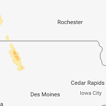
Hail Map for Tuesday, July 10, 2018

Number of Impacted Households on 7/10/2018
0
Impacted by 1" or Larger Hail
0
Impacted by 1.75" or Larger Hail
0
Impacted by 2.5" or Larger Hail
Square Miles of Populated Area Impacted on 7/10/2018
0
Impacted by 1" or Larger Hail
0
Impacted by 1.75" or Larger Hail
0
Impacted by 2.5" or Larger Hail


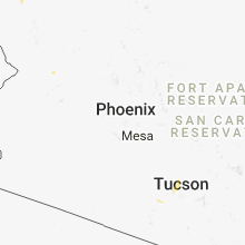


Cities Most Affected by Hail Storms of 7/10/2018
| Hail Size | Demographics of Zip Codes Affected | ||||||
|---|---|---|---|---|---|---|---|
| City | Count | Average | Largest | Pop Density | House Value | Income | Age |
Hail and Wind Damage Spotted on 7/10/2018
Filter by Report Type:Hail ReportsWind Reports
States Impacted
South Dakota, Iowa, Maine, Indiana, New York, Ohio, Vermont, Texas, New Hampshire, Missouri, Montana, North DakotaSouth Dakota
| Local Time | Report Details |
|---|---|
| 7:03 AM CDT | Storm damage reported in brown county SD, 0.8 miles NNE of Aberdeen, SD |
| 7:15 AM CDT | Storm damage reported in grant county SD, 42 miles W of Montevideo, MN |
Iowa
| Local Time | Report Details |
|---|---|
| 10:40 AM CDT | 6 inch tree limbs down. report via social medi in dickinson county IA, 47.2 miles N of Storm Lake, IA |
| 11:13 AM CDT | Half Dollar sized hail reported near Dickens, IA, 34.7 miles NNE of Storm Lake, IA, broken windows. trees stripped of leaves. branches down with estimated 1 inch diameter. |
| 11:18 AM CDT | Trees down up to 2 feet in diameter. nickel hai in clay county IA, 31 miles NNE of Storm Lake, IA |
| 11:50 AM CDT | Several reports of 50-60 mph wind and tree damage. time estimated by radar. via mpin in pocahontas county IA, 22.7 miles NE of Storm Lake, IA |
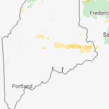
Maine
| Local Time | Report Details |
|---|---|
| 1:25 PM EDT | Quarter sized hail reported near Fort Kent, ME, 31.2 miles NW of Caribou, ME, new canada town office reports nickle and quarter sized hail. |
| 1:37 PM EDT | Quarter sized hail reported near Shirley Mills, ME, 56.9 miles NW of Bangor, ME, shirley dot worker reports hail up to one inch in diameter. |
| 3:38 PM EDT | Trees down in tow in penobscot county ME, 10.7 miles NNE of Bangor, ME |
| 3:40 PM EDT | Trees down on wire in penobscot county ME, 20.1 miles NNE of Bangor, ME |
| 3:50 PM EDT | Trees down in town. power outage in penobscot county ME, 20.1 miles NNE of Bangor, ME |
| 4:05 PM EDT | Trees dow in penobscot county ME, 10.7 miles NNE of Bangor, ME |
| 4:10 PM EDT | Reported at nicatous lake. lots of trees down along the shore line and on the 32-00-0 road. also docks were flipped and pushed into shore. time estimated and based on r in hancock county ME, 36 miles NE of Bangor, ME |
| 4:15 PM EDT | Trees down on river road in clinto in kennebec county ME, 37.6 miles WSW of Bangor, ME |
| 5:00 PM EDT | Trees down on route 22 in waldo county ME, 29.4 miles WSW of Bangor, ME |
| 5:05 PM EDT | Quarter sized hail reported near Meddybemps, ME, 71.6 miles ENE of Bangor, ME |
| 5:23 PM EDT | Large tree limbs downed at the intersection of river road and mallison roa in cumberland county ME, 9.9 miles NW of Portland, ME |
| 5:31 PM EDT | Trees down at 16 and 22 hope drive in gorha in cumberland county ME, 8.7 miles WNW of Portland, ME |
| 5:38 PM EDT | Trees down on woodford steet blocking the road in cumberland county ME, 1.8 miles WNW of Portland, ME |
| 5:38 PM EDT | Tree limbs and wires down on glecker rd in back cove area of portland in cumberland county ME, 1.9 miles NW of Portland, ME |
| 5:39 PM EDT | Trees down in libbytown area of portland in cumberland county ME, 1.2 miles W of Portland, ME |
| 5:40 PM EDT | Delayed report. power poles snapped on causeway to mackworth island. time estimated from rada in cumberland county ME, 2.9 miles NNE of Portland, ME |
Indiana
| Local Time | Report Details |
|---|---|
| 3:00 PM EDT | *** 2 fatal *** a large rotted tree was blown over by thunderstorm outflow winds. the tree landed on a pickup truck resulting in 2 fatalities. time estimated from radar in adams county IN, 33.6 miles SSE of Fort Wayne, IN |
New York
| Local Time | Report Details |
|---|---|
| 3:48 PM EDT | Tree down near bolton landing in warren county NY, 51.4 miles NNE of Schenectady, NY |
| 3:49 PM EDT | Trees and wires down near pilot knob in washington county NY, 51.3 miles NNE of Schenectady, NY |
| 4:44 PM EDT | Tree down on zorn road in guilderland in albany county NY, 10 miles SSE of Schenectady, NY |
| 4:49 PM EDT | Multiple trees down in albany county NY, 12.3 miles SSE of Schenectady, NY |
| 4:49 PM EDT | Multiple trees down at intersection of new scotland rd and hartman rd in albany county NY, 12.5 miles SSE of Schenectady, NY |
Ohio
| Local Time | Report Details |
|---|---|
| 3:58 PM EDT | Multiple 2 inch branches blown down. time estimated from rada in champaign county OH, 30.5 miles WNW of Columbus, OH |
Vermont
| Local Time | Report Details |
|---|---|
| 4:06 PM EDT | State police reports power lines down in castleton. time based off rada in rutland county VT, 59.1 miles S of Burlington, VT |
| 4:42 PM EDT | Several large trees have fallen and spotter reports loss of power. time estimated from rada in rutland county VT, 67.2 miles NE of Schenectady, NY |
| 7:06 PM EDT | Social media picture of trees down on edgewood lane in hartland. also reports of power lines down and power outages in the hartland area. time is estimated from rada in windsor county VT, 75.7 miles SSE of Burlington, VT |
Texas
| Local Time | Report Details |
|---|---|
| 3:07 PM CDT | Large tree limbs down in eules in tarrant county TX, 16.9 miles WNW of Dallas, TX |
| 11:15 PM CDT | Storm damage reported in moore county TX, 46.1 miles NNW of Amarillo, TX |
New Hampshire
| Local Time | Report Details |
|---|---|
| 5:07 PM EDT | Numberous trees and wires down at the intersection of route 4 and route 1 in merrimack county NH, 79.9 miles W of Portland, ME |
| 5:22 PM EDT | Section of interstate 93 had downed trees on southbound side in merrimack county NH, 70.9 miles WSW of Portland, ME |
| 5:32 PM EDT | Trees blocking roadway along daniel webster highwa in merrimack county NH, 72.6 miles WSW of Portland, ME |
| 6:05 PM EDT | Trees down on route 107 in rockingham county NH, 55.4 miles SW of Portland, ME |
| 7:00 PM EDT | Trees downed on buttercup lan in hillsborough county NH, 87.7 miles NNW of Providence, RI |
| 7:03 PM EDT | Numerous trees down in antri in hillsborough county NH, 87.7 miles NNW of Providence, RI |
| 7:10 PM EDT | Trees and wires down on pleasant pond roa in hillsborough county NH, 83 miles NNW of Providence, RI |
Missouri
| Local Time | Report Details |
|---|---|
| 5:11 PM CDT | Tree blown down and power line reported down on falls parkwa in taney county MO, 40.6 miles S of Springfield, MO |
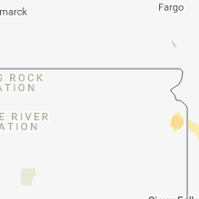
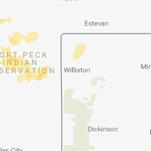
Montana
| Local Time | Report Details |
|---|---|
| 4:45 PM MDT | Malta south mtdot reported 58mph wind gus in phillips county MT, 75 miles ESE of Havre, MT |
| 4:45 PM MDT | Quarter sized hail reported near Turner, MT, 59.5 miles ENE of Havre, MT, quarter sized hail reported in ne blaine county. semi and trailer also reported to be blown over in the area. |
| 5:30 PM MDT | Estimated 60-70mph win in valley county MT, 26 miles WNW of Glasgow, MT |
| 5:30 PM MDT | Outbuildings blown down in valley county MT, 38.3 miles NW of Glasgow, MT |
| 5:36 PM MDT | Quarter sized hail reported near Hinsdale, MT, 32.5 miles W of Glasgow, MT, estimated 1 inch hail scattered in with a lot of pea sized hail. |
| 5:37 PM MDT | Winds gusted from 532 to 537 pm at 60 mp in valley county MT, 35.6 miles WNW of Glasgow, MT |
| 6:05 PM MDT | Large tree branches blown down. wind gust estimate of 60 mp in valley county MT, 2 miles W of Glasgow, MT |
| 6:25 PM MDT | Storm damage reported in valley county MT, 40 miles NNE of Glasgow, MT |
| 6:25 PM MDT | Storm damage reported in valley county MT, 2.9 miles W of Glasgow, MT |
| 6:38 PM MDT | Measured 68mph wind gust. rain 0.38 inches still raining but slacked u in valley county MT, 10.3 miles SE of Glasgow, MT |
| 6:55 PM MDT | Storm damage reported in valley county MT, 31.7 miles E of Glasgow, MT |
| 7:19 PM MDT | Asos station kolf... wolf point airpor in roosevelt county MT, 49.9 miles E of Glasgow, MT |
| 7:30 PM MDT | Accompanied by heavy rai in daniels county MT, 79.3 miles ENE of Glasgow, MT |
| 7:54 PM MDT | Storm damage reported in sheridan county MT, 61.7 miles NW of Williston, ND |
| 8:17 PM MDT | Storm damage reported in sheridan county MT, 59.5 miles NNW of Williston, ND |
| 8:17 PM MDT | Measured 75mph wind gust at the comertown turn-off sit in sheridan county MT, 54.1 miles NNW of Williston, ND |
| 8:32 PM MDT | Quarter sized hail reported near Brockton, MT, 55.4 miles W of Williston, ND, mostly nickle and dime sized hail. accompanied by 0.70 inches of rain. time estimated by radar. |
| 9:56 PM CDT | Mesonet station csbn8... 30 w crosb in divide county ND, 59.5 miles NNW of Williston, ND |
North Dakota
| Local Time | Report Details |
|---|---|
| 9:45 PM CDT | Fortuna grain elevator had its roof torn off. also some of the tin structure is damaged. time estimated from radar. report relayed by emergency manage in divide county ND, 53.2 miles N of Williston, ND |
| 10:58 PM CDT | Storm damage reported in burke county ND, 55.7 miles WNW of Minot, ND |
Connect with Interactive Hail Maps