

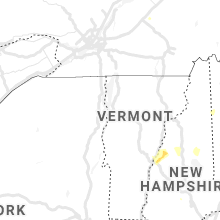
Hail Map for Monday, July 13, 2020

Number of Impacted Households on 7/13/2020
0
Impacted by 1" or Larger Hail
0
Impacted by 1.75" or Larger Hail
0
Impacted by 2.5" or Larger Hail
Square Miles of Populated Area Impacted on 7/13/2020
0
Impacted by 1" or Larger Hail
0
Impacted by 1.75" or Larger Hail
0
Impacted by 2.5" or Larger Hail


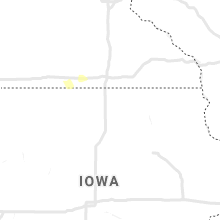

Cities Most Affected by Hail Storms of 7/13/2020
| Hail Size | Demographics of Zip Codes Affected | ||||||
|---|---|---|---|---|---|---|---|
| City | Count | Average | Largest | Pop Density | House Value | Income | Age |
| Saint Francis, KS | 1 | 1.75 | 1.75 | 2 | $50k | $31.4k | 51.1 |
Hail and Wind Damage Spotted on 7/13/2020
Filter by Report Type:Hail ReportsWind Reports
States Impacted
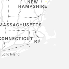
New Hampshire, Maine, North Carolina, Connecticut, Massachusetts, South Carolina, Wyoming, Colorado, Arizona, New Mexico, Nebraska, Kansas, Minnesota, South DakotaNew Hampshire
| Local Time | Report Details |
|---|---|
| 1:00 PM EDT | Trees and power lines down. reported at 182 colby road weare n in hillsborough county NH, 82.7 miles WSW of Portland, ME |
| 1:00 PM EDT | Trees and wires dow in merrimack county NH, 78.3 miles WSW of Portland, ME |
| 2:44 PM EDT | Report received via social media of 60 mph wind gust measured at port city ai in rockingham county NH, 49.3 miles SW of Portland, ME |
| 4:30 AM EDT | Lebanon police report numerous trees down in the cit in grafton county NH, 75 miles SE of Burlington, VT |
Maine
| Local Time | Report Details |
|---|---|
| 2:33 PM EDT | Multiple trees down on poor farm and shore roads. time estimated from radar. delayed repor in york county ME, 22.6 miles WSW of Portland, ME |
| 2:55 PM EDT | Wires dow in york county ME, 18 miles WSW of Portland, ME |
| 3:20 PM EDT | Trees down and trees down across the road. power outage in piscataquis county ME, 43.4 miles NNW of Bangor, ME |
| 4:45 PM EDT | Multiple reports of trees down...trees on wires... completely blocking rd at waterville and free st; trees down on french and at 130 block of main st. time est via rada in somerset county ME, 46.3 miles W of Bangor, ME |
North Carolina
| Local Time | Report Details |
|---|---|
| 3:20 PM EDT | Tree down on us 17 bypas in jones county NC, 71 miles NE of Wilmington, NC |
| 3:21 PM EDT | Duke energy reported power outages due to downed trees or limbs on electrical equipment. time based on rada in jones county NC, 71 miles NE of Wilmington, NC |
| 3:24 PM EDT | Quarter sized hail reported near New Bern, NC, 72.2 miles NE of Wilmington, NC, craven county comms reports rhems vfd observed quarter-sized hail at the station. |
| 4:24 PM EDT | Quarter sized hail reported near La Grange, NC, 52.7 miles ESE of Raleigh, NC |
| 4:39 PM EDT | Carteret county 911 center reports power lines down at the dunkin donuts on cedar island blvd. time estimated by rada in carteret county NC, 57.7 miles ENE of Wilmington, NC |
| 6:59 PM EDT | Trees down on power line in johnston county NC, 22 miles SSE of Raleigh, NC |
| 7:55 PM EDT | Tree down on power line in wake county NC, 10.6 miles SSW of Raleigh, NC |
Connecticut
| Local Time | Report Details |
|---|---|
| 3:25 PM EDT | Large tree down and blocking route 89 north of route 4 in windham county CT, 36.7 miles W of Providence, RI |
| 3:30 PM EDT | Almond tree down at bigelow brook farm road and tree down across fire tower road near the section that becomes chase hill roa in windham county CT, 34.9 miles W of Providence, RI |
Massachusetts
| Local Time | Report Details |
|---|---|
| 3:38 PM EDT | Large tree down blocking one lane on johnson stree in essex county MA, 62.3 miles NNE of Providence, RI |
| 6:28 PM EDT | Tree and wires down on upper palmer roa in hampden county MA, 50 miles WNW of Providence, RI |
| 6:30 PM EDT | Multiple trees down on wires and part of a pole taken down on brimfield road at crest roa in hampden county MA, 50 miles WNW of Providence, RI |
| 6:35 PM EDT | Tree down at 20 town farm road... which is blocking the roa in hampden county MA, 50 miles WNW of Providence, RI |
| 7:00 PM EDT | Large branch down on old palmer road in hampden county MA, 45.4 miles WNW of Providence, RI |
| 8:35 PM EDT | Window broken due to flying debris in berkshire county MA, 61.4 miles SE of Schenectady, NY |
| 8:40 PM EDT | Large tree down... partially blocking gibbs road... route 23 near the highway garag in hampden county MA, 67.6 miles SE of Schenectady, NY |
South Carolina
| Local Time | Report Details |
|---|---|
| 3:49 PM EDT | Quarter sized hail reported near Mount Croghan, SC, 46 miles SE of Charlotte, NC, mostly dime... some quarter size hail reported by a business just north of mt.croghan. |
| 3:50 PM EDT | Quarter sized hail reported near Mount Croghan, SC, 46.5 miles SE of Charlotte, NC, report on social media of mostly marble... some quarter size hail at croghan street in mt.croghan. |
| 3:58 PM EDT | Business reported tree on a house in ruby. time estimated based on rada in chesterfield county SC, 49.5 miles SE of Charlotte, NC |
| 5:16 PM EDT | Sc highway patrol reported two trees down. one tree was downed on squaw valley rd at hwy 261 and the other was downed on bronco rd at cane savannah rd. time estimated b in sumter county SC, 57.8 miles NNW of Charleston, SC |
Wyoming
| Local Time | Report Details |
|---|---|
| 2:06 PM MDT | Mesonet station wy15 14.5 e sinclair (wydot in carbon county WY, 71.3 miles WNW of Laramie, WY |
| 2:16 PM MDT | Corrects previous non-tstm wnd gst report from 9 wnw elk mountain. mesonet station wy17 8.9 s hanna (wydot in carbon county WY, 58.8 miles WNW of Laramie, WY |
| 2:26 PM MDT | I-80 elk mountain mesonet site sustained wind 31mph... wind gust 62mp in carbon county WY, 56.5 miles WNW of Laramie, WY |
| 2:26 PM MDT | I-80 elk mountain mesonet site sustained wind 31mph... wind gust 62mp in carbon county WY, 56.5 miles WNW of Laramie, WY |
| 2:43 PM MDT | Cow cree in carbon county WY, 54.9 miles N of Craig, CO |
| 2:56 PM MDT | Mesonet station kskl skyline (wydot in carbon county WY, 52.9 miles WSW of Laramie, WY |
| 3:06 PM MDT | Storm damage reported in carbon county WY, 42.8 miles WNW of Laramie, WY |
| 3:06 PM MDT | Corrects previous tstm wnd gst report from 3 nw arlington. i80 - foote cree in carbon county WY, 39.9 miles WNW of Laramie, WY |
| 3:30 PM MDT | Mesonet station fw4449 larami in albany county WY, 17.1 miles SW of Laramie, WY |
| 3:42 PM MDT | Mesonet station kpum pumpkin vine (wydot in albany county WY, 19.1 miles SSE of Laramie, WY |
| 3:52 PM MDT | Mesonet station wy36 2.4 nw buford (wydot in albany county WY, 18 miles SE of Laramie, WY |
| 3:52 PM MDT | Mesonet station kvdw vedauwoo (wydot in albany county WY, 14.4 miles SE of Laramie, WY |
| 3:53 PM MDT | Asos station klar laramie airport - la in albany county WY, 4.2 miles W of Laramie, WY |
| 3:55 PM MDT | Upr site 60mph mesonet wind gus in laramie county WY, 27 miles SE of Laramie, WY |
| 4:04 PM MDT | Corrects previous tstm wnd gst report from 3 ne pumpkin vine. dalew in albany county WY, 18.2 miles SSE of Laramie, WY |
| 4:10 PM MDT | Corrects previous tstm wnd gst report from 7 sw federal. wy210 - wildcat trai in laramie county WY, 22 miles ESE of Laramie, WY |
| 4:10 PM MDT | Id: up226 name: emkay in laramie county WY, 32.8 miles ESE of Laramie, WY |
| 4:12 PM MDT | Corrects previous tstm wnd gst report from 12 wsw warren af base. i80/us30 - ott in laramie county WY, 30.8 miles ESE of Laramie, WY |
| 4:16 PM MDT | I80/us3 in laramie county WY, 35.2 miles ESE of Laramie, WY |
| 4:24 PM MDT | I80/us3 in laramie county WY, 35.2 miles ESE of Laramie, WY |
| 4:28 PM MDT | Cheyenne airport wind gust 61mp in laramie county WY, 41.9 miles ESE of Laramie, WY |
| 4:28 PM MDT | Cheyenne airport wind gust 61mp in laramie county WY, 41.9 miles ESE of Laramie, WY |
Colorado
| Local Time | Report Details |
|---|---|
| 2:33 PM MDT | Mesonet station cw5040 briggsdal in weld county CO, 78.3 miles ESE of Laramie, WY |
| 2:43 PM MDT | Awos station k1ow oscar madi in weld county CO, 70 miles SSW of Scottsbluff, NE |
| 2:57 PM MDT | Storm damage reported in jackson county CO, 52.5 miles SW of Laramie, WY |
| 3:00 PM MDT | Mesonet station gspc2 gunsight. time is estimate in grand county CO, 67.6 miles ESE of Craig, CO |
| 4:00 PM MDT | Storm damage reported in las animas county CO, 96 miles SE of Pueblo, CO |
| 4:10 PM MDT | Mesonet station co166 cr-82 buckeye r in larimer county CO, 45.9 miles SE of Laramie, WY |
| 4:20 PM MDT | Asos station keeo meeker airpor in rio blanco county CO, 36.5 miles SSW of Craig, CO |
| 4:35 PM MDT | Mesonet station beyc2 buckey in larimer county CO, 44.9 miles SE of Laramie, WY |
| 4:41 PM MDT | Storm damage reported in weld county CO, 69.2 miles SE of Laramie, WY |
| 4:46 PM MDT | Mesonet station cw2715 aul in weld county CO, 69.2 miles SE of Laramie, WY |
| 4:50 PM MDT | Trained spotter reported power poles down. time estimate in weld county CO, 70.3 miles NNE of Denver, CO |
| 4:55 PM MDT | Spotter network reported damage to buildings. metal shed... twisted. time estimate in weld county CO, 69.8 miles ESE of Laramie, WY |
| 5:03 PM MDT | Mesonet station cw5040 briggsdal in weld county CO, 78.3 miles ESE of Laramie, WY |
| 5:07 PM MDT | Storm damage reported in weld county CO, 71.6 miles NNE of Denver, CO |
| 5:25 PM MDT | Time estimated by rada in kit carson county CO, 55.8 miles S of Yuma, CO |
| 5:30 PM MDT | Relayed from emergency managemen in yuma county CO, 18.8 miles NNE of Yuma, CO |
| 6:07 PM MDT | Mesonet station tt567 crow cree in weld county CO, 71.6 miles NNE of Denver, CO |
| 6:08 PM MDT | Time estimated from rada in kit carson county CO, 61.2 miles SSE of Yuma, CO |
| 6:33 PM MDT | Asos station kako akro in washington county CO, 26.6 miles W of Yuma, CO |
| 7:39 PM MDT | Corrects previous tstm wnd dmg report from wra in yuma county CO, 26.3 miles E of Yuma, CO |
| 8:00 PM MDT | Quarter sized hail reported near Wray, CO, 32.5 miles ESE of Yuma, CO, public report of quarter size hail estimated at 8pm mdt. |
| 8:20 PM MDT | Public reported 60mph wind gust via faceboo in kit carson county CO, 60.8 miles SSE of Yuma, CO |
Arizona
| Local Time | Report Details |
|---|---|
| 1:52 PM MST | Adot weather sensor on i-40 @ painted desert np hq (azt13) measured a 64 mph wind gus in apache county AZ, 57.8 miles NNE of Show Low, AZ |
New Mexico
| Local Time | Report Details |
|---|---|
| 3:59 PM MDT | Kabq aso in bernalillo county NM, 3.5 miles SSE of Albuquerque, NM |
| 4:20 PM MDT | 30 foot tall live tree uprooted at academy and wyomin in bernalillo county NM, 7.4 miles NNE of Albuquerque, NM |
| 5:31 PM MDT | Kcqc aso in torrance county NM, 56.4 miles E of Albuquerque, NM |
| 8:05 PM MDT | Storm damage reported in chaves county NM, 13.6 miles WSW of Roswell, NM |
Nebraska
| Local Time | Report Details |
|---|---|
| 6:45 PM CDT | Quarter sized hail reported near Sutherland, NE, 31.2 miles NW of North Platte, NE |
| 6:29 PM MDT | Home weather station pws-kneelsie2 in perkins county NE, 38.7 miles WSW of North Platte, NE |
| 7:05 PM MDT | Storm damage reported in perkins county NE, 35.2 miles SW of North Platte, NE |
| 8:23 PM CDT | Home weather station pws-knenorth15 in lincoln county NE, 5.3 miles S of North Platte, NE |
| 8:25 PM CDT | Reported from bailey yar in lincoln county NE, 3.6 miles WNW of North Platte, NE |
| 8:30 PM CDT | Storm damage reported in lincoln county NE, 1.2 miles SSW of North Platte, NE |
| 8:34 PM CDT | Nws rsois gust to 73 mph in lincoln county NE, 3.3 miles E of North Platte, NE |
| 8:35 PM CDT | Lots of tree damage along highway 8 in lincoln county NE, 3.2 miles S of North Platte, NE |
| 8:41 PM CDT | Klbf aso in lincoln county NE, 3.8 miles E of North Platte, NE |
| 8:42 PM CDT | 12 inch tree limb downed in lincoln county NE, 1 miles WSW of North Platte, NE |
| 8:45 PM CDT | Trained spotter reports flag pole snapped at bas in lincoln county NE, 2.5 miles W of North Platte, NE |
| 8:56 PM CDT | Storm damage reported in lincoln county NE, 12.8 miles ESE of North Platte, NE |
| 9:05 PM CDT | Storm damage reported in lincoln county NE, 29.6 miles SSE of North Platte, NE |
| 8:12 PM MDT | Public reported via facebook 60mph winds in tow in dundy county NE, 52.5 miles NNW of Colby, KS |
| 9:20 PM CDT | Storm damage reported in lincoln county NE, 22 miles ESE of North Platte, NE |
| 8:21 PM MDT | Estimated wind gust of 58 mp in dundy county NE, 51.9 miles NNW of Colby, KS |
| 9:23 PM CDT | Storm damage reported in dawson county NE, 33.3 miles ESE of North Platte, NE |
| 9:23 PM CDT | Storm damage reported in dawson county NE, 41.3 miles SE of North Platte, NE |
| 9:40 PM CDT | Storm damage reported in frontier county NE, 50.5 miles SE of North Platte, NE |
| 9:48 PM CDT | Mesonet reported a 62 mph wind gust at 8:48pm mt/ 9:48 c in hitchcock county NE, 54.7 miles N of Colby, KS |
| 10:11 PM CDT | Storm damage reported in gosper county NE, 59.7 miles SE of North Platte, NE |
| 10:15 PM CDT | Awos station klxn lexington airpor in dawson county NE, 57.5 miles ESE of North Platte, NE |
| 10:28 PM CDT | Corrects previous tstm wnd gst report from mccook. asos recorded at 79mph wind gust at 9:28m in red willow county NE, 60.5 miles NNE of Colby, KS |
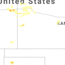
Kansas
| Local Time | Report Details |
|---|---|
| 8:34 PM CDT | Golf Ball sized hail reported near Saint Francis, KS, 38.9 miles ESE of Yuma, CO |
| 8:42 PM CDT | Half Dollar sized hail reported near Saint Francis, KS, 42.3 miles ESE of Yuma, CO, trained spotter reported 1/2 dollar size hail at intersection road 5 and road z. |
| 8:12 PM MDT | Quarter sized hail reported near Sharon Springs, KS, 43.2 miles WSW of Colby, KS |
| 10:04 PM CDT | Mesonet reported at 65 mph wind gust at 9:04pm mt/ 10:04pm c in rawlins county KS, 38.4 miles N of Colby, KS |
| 9:07 PM MDT | Nws employee reported a 60-70mph wind gus in sherman county KS, 27.8 miles WNW of Colby, KS |
| 10:30 PM CDT | Mesonet reported a 63mph wind gust at 930pm m in thomas county KS, 17.8 miles WNW of Colby, KS |
| 9:35 PM MDT | Quarter sized hail reported near Goodland, KS, 35.2 miles W of Colby, KS, hail at nws office at varying in size... biggest appears to be 1 inch. |
| 10:35 PM CDT | Awos reported a 58mph wind gust at 9:35pm md in decatur county KS, 40.6 miles NE of Colby, KS |
| 10:50 PM CDT | Quarter sized hail reported near Colby, KS, 0.6 miles SSW of Colby, KS, spotter reported hail to the size of quarters. |
| 9:50 PM MDT | Half Dollar sized hail reported near Goodland, KS, 36.3 miles W of Colby, KS, off duty nws employee reported 1.25 hail. |
| 9:56 PM MDT | Quarter sized hail reported near Goodland, KS, 35.1 miles W of Colby, KS, quarter size hail at nws office at 9:56pm mt. |
| 10:05 PM MDT | Quarter sized hail reported near Goodland, KS, 35.8 miles W of Colby, KS, nws employee reported quarter size hail. |
| 10:07 PM MDT | Ping Pong Ball sized hail reported near Goodland, KS, 36.3 miles W of Colby, KS, off duty nws employee reports 1.5 inch hail. |
| 3:15 AM CDT | 50 to 60 mp in barton county KS, 38.4 miles SE of Hays, KS |
| 3:18 AM CDT | Storm damage reported in barton county KS, 41.5 miles SE of Hays, KS |
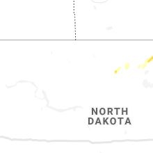
Minnesota
| Local Time | Report Details |
|---|---|
| 9:42 PM CDT | Small limbs were downed. approximately 1-2 inches in diamete in cass county MN, 41.2 miles SSE of Bemidji, MN |
| 11:38 PM CDT | Quarter sized hail reported near Pierz, MN, 80.4 miles NNW of Minneapolis, MN |
South Dakota
| Local Time | Report Details |
|---|---|
| 11:23 PM MDT | Quarter sized hail reported near Piedmont, SD, 13.8 miles NW of Rapid City, SD, mostly dime to nickel size |
Connect with Interactive Hail Maps