

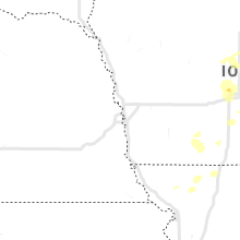
Hail Map for Tuesday, July 14, 2020

Number of Impacted Households on 7/14/2020
0
Impacted by 1" or Larger Hail
0
Impacted by 1.75" or Larger Hail
0
Impacted by 2.5" or Larger Hail
Square Miles of Populated Area Impacted on 7/14/2020
0
Impacted by 1" or Larger Hail
0
Impacted by 1.75" or Larger Hail
0
Impacted by 2.5" or Larger Hail


Cities Most Affected by Hail Storms of 7/14/2020
| Hail Size | Demographics of Zip Codes Affected | ||||||
|---|---|---|---|---|---|---|---|
| City | Count | Average | Largest | Pop Density | House Value | Income | Age |
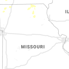
| Grimes, IA | 2 | 2.00 | 2.00 | 359 | $123k | $57.9k | 31.6 |
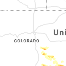
| Yoder, CO | 1 | 1.75 | 1.75 | 6 | $90k | $36.0k | 40.0 |
Hail and Wind Damage Spotted on 7/14/2020
Filter by Report Type:Hail ReportsWind Reports
States Impacted
Minnesota, Maine, Massachusetts, New Hampshire, Connecticut, Rhode Island, New York, Mississippi, Wisconsin, Arizona, Florida, Colorado, Iowa, New Mexico, Texas, Oklahoma, KansasMinnesota
| Local Time | Report Details |
|---|---|
| 7:33 AM CDT | Quarter sized hail reported near Hastings, MN, 27.9 miles SE of Minneapolis, MN |
| 7:38 AM CDT | Quarter sized hail reported near Hastings, MN, 26.2 miles SE of Minneapolis, MN, time estimated from radar. |
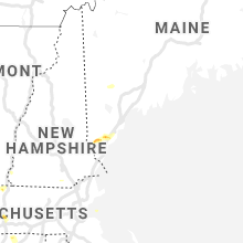
Maine
| Local Time | Report Details |
|---|---|
| 8:50 AM EDT | Multiple trees down on houses. reported at winter mills road sanfor in york county ME, 30.3 miles WSW of Portland, ME |
| 8:50 AM EDT | Multiple trees down on houses. reported at new dam road sanfor in york county ME, 26.9 miles SW of Portland, ME |
| 8:50 AM EDT | Quarter sized hail reported near Sanford, ME, 30.2 miles WSW of Portland, ME |
| 8:54 AM EDT | Quarter sized hail reported near Kennebunk, ME, 23.4 miles SW of Portland, ME |
| 8:54 AM EDT | Multiple trees down with damage to houses and mobile home. 3/4 inch hail also reported. reported at whitcher mill road sanford m in york county ME, 30.2 miles WSW of Portland, ME |
| 8:55 AM EDT | Ping Pong Ball sized hail reported near Sanford, ME, 29.7 miles SW of Portland, ME |
| 8:55 AM EDT | Ping Pong Ball sized hail reported near Sanford, ME, 29.4 miles SW of Portland, ME, hundreds of cars damaged at a dealership. several with broken windows. |
| 9:42 AM EDT | Tree down in roadway. reported at kennebunk road sanford m in york county ME, 27.8 miles SW of Portland, ME |
| 9:54 AM EDT | Half Dollar sized hail reported near Biddeford, ME, 16.6 miles SW of Portland, ME, 1.3 inch hail reported at the intersection of granite and west street. |
| 9:54 AM EDT | Quarter sized hail reported near Biddeford, ME, 15.2 miles SW of Portland, ME |
Massachusetts
| Local Time | Report Details |
|---|---|
| 12:15 PM EDT | Quarter sized hail reported near South Hadley, MA, 67.1 miles WNW of Providence, RI |
| 12:20 PM EDT | Large tree down on southbound lane of rte 91 in hampden county MA, 68.6 miles WNW of Providence, RI |
| 12:25 PM EDT | Half Dollar sized hail reported near South Hadley, MA, 67.1 miles WNW of Providence, RI |
| 12:34 PM EDT | Tree down on wires on mount hermon station road blocking road in franklin county MA, 76.7 miles E of Schenectady, NY |
New Hampshire
| Local Time | Report Details |
|---|---|
| 12:15 PM EDT | Ping Pong Ball sized hail reported near Winchester, NH, 78.4 miles E of Schenectady, NY, person reports hail between 1.25-1.5in... beginning at 12:15. |
| 3:20 PM EDT | Quarter sized hail reported near Litchfield, NH, 68.8 miles N of Providence, RI, time estimated from radar. |
| 3:22 PM EDT | Half Dollar sized hail reported near Litchfield, NH, 67.4 miles N of Providence, RI, down branches also reported. |
| 3:29 PM EDT | Quarter sized hail reported near Merrimack, NH, 69.7 miles N of Providence, RI |
| 4:27 PM EDT | Quarter sized hail reported near East Hampstead, NH, 69.3 miles SW of Portland, ME |
Connecticut
| Local Time | Report Details |
|---|---|
| 1:20 PM EDT | Quarter sized hail reported near Ellington, CT, 54.8 miles W of Providence, RI |
| 1:20 PM EDT | Tree down on hoffman road in tolland county CT, 54.8 miles W of Providence, RI |
| 1:20 PM EDT | Tree down on hutton road in tolland county CT, 54.6 miles WNW of Providence, RI |
| 1:25 PM EDT | Quarter sized hail reported near Ellington, CT, 54.8 miles W of Providence, RI |
Rhode Island
| Local Time | Report Details |
|---|---|
| 2:15 PM EDT | Large tree down on windermere road in washington county RI, 27.3 miles S of Providence, RI |
| 2:30 PM EDT | Large branches down on williamsburg drive in kent county RI, 8.6 miles S of Providence, RI |
| 2:30 PM EDT | Large branches down on williamsburg drive in kent county RI, 8.6 miles S of Providence, RI |
| 3:00 PM EDT | Large tree down in the area of newport harbor... large branches with power outages on easton beach and area of bellevue avenu in newport county RI, 23.5 miles SSE of Providence, RI |
| 3:00 PM EDT | Large tree down in the area of newport harbor... large branches with power outages on easton beach and area of bellevue avenu in newport county RI, 23.5 miles SSE of Providence, RI |
| 3:19 PM EDT | Half Dollar sized hail reported near Wakefield, RI, 28.1 miles SSW of Providence, RI |
New York
| Local Time | Report Details |
|---|---|
| 2:24 PM EDT | Trees down. two poles snapped. wires sparking. kashmiri terrace and cherry lan in saratoga county NY, 8.6 miles ENE of Schenectady, NY |
| 2:24 PM EDT | Trees and wires dow in saratoga county NY, 10 miles ENE of Schenectady, NY |
| 2:24 PM EDT | Trees down. wires sparkin in saratoga county NY, 5.7 miles E of Schenectady, NY |
| 2:48 PM EDT | Trees and wires dow in saratoga county NY, 17.1 miles N of Schenectady, NY |
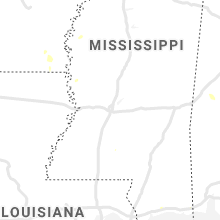
Mississippi
| Local Time | Report Details |
|---|---|
| 2:20 PM CDT | One tree and powerline down. kgpt measured wind gust of 48 mph near the time of the damage repor in harrison county MS, 64 miles WSW of Mobile, AL |
| 3:50 PM CDT | Pictures showing multiple snapped and split large trees near the intersection of east street and ms highway 14 were relayed via local media on twitter. several fell acr in sharkey county MS, 58.6 miles NW of Jackson, MS |
Wisconsin
| Local Time | Report Details |
|---|---|
| 4:18 PM CDT | Small trees and large branches down. time estimate in eau claire county WI, 60.8 miles N of La Crosse, WI |
| 4:20 PM CDT | Trees on wires in town. time estimate in eau claire county WI, 60.2 miles N of La Crosse, WI |
| 7:27 PM CDT | Tree down on power line. time estimated by rada in wood county WI, 75.6 miles SSW of Rhinelander, WI |
Arizona
| Local Time | Report Details |
|---|---|
| 2:30 PM MST | Spotter reported a few medium sized mesquite branches were snapped from thunderstorm wind in cochise county AZ, 49.3 miles ESE of Tucson, AZ |
Florida
| Local Time | Report Details |
|---|---|
| 5:43 PM EDT | Communications and electrical services down from a fallen tree in the 600 block of simmons trail. significant small limbs and debris along sunbridge road from henley ro in clay county FL, 21.5 miles SSW of Jacksonville, FL |
Colorado
| Local Time | Report Details |
|---|---|
| 3:54 PM MDT | Mesonet station co101 082w023 basalt-holland hill in pitkin county CO, 84.2 miles SSE of Craig, CO |
| 4:00 PM MDT | Ping Pong Ball sized hail reported near Rush, CO, 49.3 miles NE of Pueblo, CO, social media post. |
| 4:15 PM MDT | Golf Ball sized hail reported near Yoder, CO, 45.1 miles NNE of Pueblo, CO, relayed via media. |
| 8:17 PM MDT | Asos station kspd 8 s springfiel in baca county CO, 107 miles WSW of Garden City, KS |
Iowa
| Local Time | Report Details |
|---|---|
| 6:20 PM CDT | Quarter sized hail reported near Boone, IA, 41.3 miles NNW of Des Moines, IA, spotter reported quarter sized hail north of boone. |
| 7:05 PM CDT | Trees down in des moines beaverdale neighborhood. time estimate in polk county IA, 3.5 miles NW of Des Moines, IA |
| 7:10 PM CDT | Tree down in road. via social media. time estimate in polk county IA, 6.5 miles W of Des Moines, IA |
| 7:15 PM CDT | Power lines down. via social media. time estimate in polk county IA, 3.5 miles NNW of Des Moines, IA |
| 7:44 PM CDT | Hen Egg sized hail reported near Grimes, IA, 11.8 miles NW of Des Moines, IA, via social media. |
| 7:45 PM CDT | Several reports of trees blown down in the camp dodge area along 70t in polk county IA, 8.6 miles NW of Des Moines, IA |
| 7:45 PM CDT | Quarter sized hail reported near Ankeny, IA, 9.2 miles NNE of Des Moines, IA |
| 7:45 PM CDT | Hen Egg sized hail reported near Grimes, IA, 11.4 miles NW of Des Moines, IA, via social media. |
| 7:57 PM CDT | Quarter sized hail reported near Ankeny, IA, 8.3 miles N of Des Moines, IA |
| 8:00 PM CDT | Damage to several large tree in polk county IA, 8.2 miles NNW of Des Moines, IA |
| 8:07 PM CDT | Public calls in repor in polk county IA, 4.7 miles NW of Des Moines, IA |
| 8:13 PM CDT | Delayed report - on grand in wdm between 8th and 4th - large trees down... power lines down... and traffic signal blown dow in polk county IA, 4.9 miles W of Des Moines, IA |
| 8:15 PM CDT | All the corn near beaver drive and hwy 415 has been flattened in the same directio in polk county IA, 8.6 miles NW of Des Moines, IA |
| 8:20 PM CDT | Large tree damaged near 22nd and ashwort in polk county IA, 6.4 miles W of Des Moines, IA |
| 8:43 PM CDT | Iowa dot relayed report of stop sign blown over at highway 163 ext on west side of monroe. time estimated from rada in jasper county IA, 25.4 miles E of Des Moines, IA |
| 8:45 PM CDT | Trees down along highway 92 near mm 140. time estimated by rada in warren county IA, 19.2 miles SE of Des Moines, IA |
| 8:47 PM CDT | Iowa dot relayed report of stop sign blown over at highway 163 exit on the west side of monro in jasper county IA, 25.4 miles E of Des Moines, IA |
| 8:58 PM CDT | Iowa dot reported downed trees near/just west of sandyville along highway 92. time estimated from rada in warren county IA, 18.9 miles SE of Des Moines, IA |
| 9:09 PM CDT | Public relayed picture of large tree branches down... likely 6 inches in diameter or greate in marion county IA, 38.2 miles ESE of Des Moines, IA |
| 9:45 PM CDT | Quarter sized hail reported near Melcher-dallas, IA, 31.6 miles SE of Des Moines, IA, krls radio relayed public pictures hail just larger than quarters. |
New Mexico
| Local Time | Report Details |
|---|---|
| 5:36 PM MDT | Dunken raw in chaves county NM, 55 miles SW of Roswell, NM |
Texas
| Local Time | Report Details |
|---|---|
| 8:18 PM CDT | Power pole half knocked over at 5th and front (west side of gruver). was a street tank moved 50ft. and a steel fence moved 120 ft in the neighborhood. time estimated fr in hansford county TX, 76.4 miles NNE of Amarillo, TX |
| 8:35 PM CDT | A peak wind gust of 67 mph was recorded at 8:35 pm cdt. another wind gust of 60 mph was recorded five minutes prior at 8:30 pm cdt. this gust was generated by shallow in floyd county TX, 41.3 miles NE of Lubbock, TX |
| 8:38 PM CDT | Storm damage reported in hansford county TX, 87.6 miles NNE of Amarillo, TX |
| 8:41 PM CDT | Storm damage reported in hansford county TX, 87.6 miles NNE of Amarillo, TX |
Oklahoma
| Local Time | Report Details |
|---|---|
| 8:20 PM CDT | Storm damage reported in texas county OK, 96.9 miles N of Amarillo, TX |
| 8:20 PM CDT | Half of a roof blown off of a mobile home. some 6 inch diameter tree limbs downe in texas county OK, 96 miles N of Amarillo, TX |
| 10:30 PM CDT | Storm damage reported in texas county OK, 87.9 miles SW of Garden City, KS |
Kansas
| Local Time | Report Details |
|---|---|
| 10:17 PM CDT | Mesonet station cw8810 elkhar in morton county KS, 88 miles SW of Garden City, KS |
| 10:23 PM CDT | Mesonet station cglk1 cimarro in morton county KS, 80.3 miles SW of Garden City, KS |
| 10:57 PM CDT | Mesonet station svuk1 mosco in stevens county KS, 49.8 miles SW of Garden City, KS |
| 11:31 PM CDT | Awos station klbl libera in seward county KS, 65 miles S of Garden City, KS |
| 11:33 PM CDT | Mesonet station sauk1 satant in seward county KS, 46.2 miles S of Garden City, KS |
| 1:49 AM CDT | Numerous tree limbs dow in reno county KS, 41 miles NW of Wichita, KS |
| 1:58 AM CDT | Trees downed in tow in reno county KS, 41 miles NW of Wichita, KS |
| 2:06 AM CDT | Storm damage reported in mcpherson county KS, 49.6 miles NNW of Wichita, KS |
| 2:11 AM CDT | Storm damage reported in mcpherson county KS, 49.6 miles NNW of Wichita, KS |
| 2:12 AM CDT | Trees downed with multiple power outage in mcpherson county KS, 50.3 miles NNW of Wichita, KS |
| 2:13 AM CDT | Semi-trailers blown off i-135 near exit 6 in mcpherson county KS, 49.6 miles NNW of Wichita, KS |
| 2:13 AM CDT | Power poles downe in mcpherson county KS, 50.4 miles NNW of Wichita, KS |
| 2:42 AM CDT | Storm damage reported in marion county KS, 46.3 miles N of Wichita, KS |
Connect with Interactive Hail Maps