

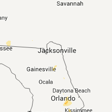
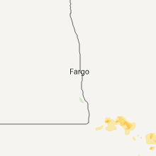
Hail Map for Friday, July 15, 2011

Number of Impacted Households on 7/15/2011
0
Impacted by 1" or Larger Hail
0
Impacted by 1.75" or Larger Hail
0
Impacted by 2.5" or Larger Hail
Square Miles of Populated Area Impacted on 7/15/2011
0
Impacted by 1" or Larger Hail
0
Impacted by 1.75" or Larger Hail
0
Impacted by 2.5" or Larger Hail


Cities Most Affected by Hail Storms of 7/15/2011
| Hail Size | Demographics of Zip Codes Affected | ||||||
|---|---|---|---|---|---|---|---|
| City | Count | Average | Largest | Pop Density | House Value | Income | Age |
Hail and Wind Damage Spotted on 7/15/2011
Filter by Report Type:Hail ReportsWind Reports
States Impacted
Minnesota, Florida, Georgia, Kansas, Nebraska, Idaho, Montana, North Dakota, Colorado, IowaMinnesota
| Local Time | Report Details |
|---|---|
| 12:13 PM UTC | Quarter sized hail reported near South Shore, MN, 68.1 miles N of Montevideo, MN |
| 12:25 PM UTC | Quarter sized hail reported near Herman, MN, 65.4 miles NNW of Montevideo, MN |
| 1:45 PM UTC | County emergency manager reports a home under construction along 300th st suffered damage along with several uprooted tree in stearns county MN, 70 miles NE of Montevideo, MN |
| 5:40 PM UTC | Tree damage...6 to 8 inch limb in rice county MN, 38 miles S of Minneapolis, MN |
| 6:15 PM UTC | Estimate 50 mph 3 to 4 inch tree limbs down in goodhue county MN, 55.9 miles SSE of Minneapolis, MN |
| 7:00 PM UTC | Storm damage reported in cottonwood county MN, 80.5 miles SSE of Montevideo, MN |
| 7:59 PM UTC | Tree down on a roof of trailer in blue earth county MN, 75.7 miles SW of Minneapolis, MN |
| 8:30 PM UTC | Wind e 50 mph power lines down also flash flooding in waseca county MN, 63.2 miles S of Minneapolis, MN |
| 9:28 PM UTC | Some flattened corn near waltha in mower county MN, 49.2 miles NNE of Mason City, IA |
| 9:50 PM UTC | Also 1.25 inches of rain in mower county MN, 50.2 miles NE of Mason City, IA |
Florida
| Local Time | Report Details |
|---|---|
| 5:16 PM UTC | Trees down near greenville in madison county FL, 38.3 miles E of Tallahassee, FL |
| 5:17 PM UTC | Powerlines down in madison county FL, 52.6 miles E of Tallahassee, FL |
| 5:17 PM UTC | Powerlines down in madison county FL, 49.6 miles E of Tallahassee, FL |
| 5:27 PM UTC | Trees down along county road 53 in madison county FL, 51.6 miles E of Tallahassee, FL |
| 6:00 PM UTC | The sheriffs office reported trees and powerlines down in the jasper city limits. time given was based on rada in hamilton county FL, 68.2 miles S of Douglas, GA |
| 6:00 PM UTC | The sheriffs office reported trees and powerlines down in and near the jasper city limits. the time given was based on rada in hamilton county FL, 66.7 miles S of Douglas, GA |
| 6:03 PM UTC | Trees down along state highway 12 in union county FL, 37.3 miles WSW of Jacksonville, FL |
| 8:10 PM UTC | Quarter sized hail reported near Orlando, FL, 4.1 miles E of Orlando, FL, quarter sized hail reported by orlando media near the intersection of highways 408 and 436. |
| 8:38 PM UTC | Large tree limbs down. time estimated by rada in lake county FL, 34.5 miles NW of Orlando, FL |
Georgia
| Local Time | Report Details |
|---|---|
| 6:05 PM UTC | Tin roof on two chicken houses removed. one large oak tree also knocked dow in brooks county GA, 42 miles ENE of Tallahassee, FL |
Kansas
| Local Time | Report Details |
|---|---|
| 10:52 PM UTC | Quarter sized hail reported near Grinnell, KS, 28.3 miles SE of Colby, KS, estimated 0.5 inches of rain in 10 minutes. |
| 12:49 AM UTC | Storm damage reported in cloud county KS, 64.7 miles WNW of Manhattan, KS |
| 12:50 AM UTC | Storm damage reported in republic county KS, 65.7 miles WNW of Manhattan, KS |
| 1:05 AM UTC | Storm damage reported in republic county KS, 60.8 miles NW of Manhattan, KS |
| 1:05 AM UTC | 4 to 5 inch diameter tree limb dow in republic county KS, 60.8 miles NW of Manhattan, KS |
| 1:20 AM UTC | Half Dollar sized hail reported near McDonald's, KS, 20.9 miles NNW of Colby, KS |
| 1:22 AM UTC | Irrigation pivot reported overturned along with tree limbs down across clyd in cloud county KS, 52 miles WNW of Manhattan, KS |
| 2:20 AM UTC | Quarter sized hail reported near McDonald's, KS, 39.8 miles NNW of Colby, KS |
Nebraska
| Local Time | Report Details |
|---|---|
| 11:50 PM UTC | Storm damage reported in adams county NE, 33.4 miles SSW of Grand Island, NE |
| 11:50 PM UTC | Relayed from khas tv...grain elevator leg/shaft collapsed and a tree was completely uprooted in tow in adams county NE, 33.4 miles SSW of Grand Island, NE |
| 1:20 AM UTC | Uprooted trees in cemetery near highway 281 and stolley park road. time estimated from radar dat in hall county NE, 1.6 miles WSW of Grand Island, NE |
| 2:40 AM UTC | Estimated 60 mph winds in town in merrick county NE, 44.8 miles NE of Grand Island, NE |
| 2:56 AM UTC | Power lines down and 6 inch diameter tree branches down in merrick county NE, 44.8 miles NE of Grand Island, NE |
Idaho
| Local Time | Report Details |
|---|---|
| 11:51 PM UTC | Measured at kriley creek raws at 5200 fee in lemhi county ID, 11.3 miles N of Salmon, ID |
Montana
| Local Time | Report Details |
|---|---|
| 12:10 AM UTC | Quarter sized hail reported near Winnett, MT, 88.2 miles N of Billings, MT, few quarters...mostly pea to penny size hail |
| 12:18 AM UTC | Dime size hail and about 1 inch of rai in musselshell county MT, 47.4 miles N of Billings, MT |
| 4:08 AM UTC | Storm damage reported in dawson county MT, 72.7 miles NE of Miles City, MT |
| 4:10 AM UTC | Storm damage reported in judith basin county MT, 43.6 miles ESE of Great Falls, MT |
| 4:45 AM UTC | Winds measured in excess of 60 mph. several large trees are down in town. some of the tree diameters were at least two feet wid in richland county MT, 58.6 miles SW of Williston, ND |
| 4:45 AM UTC | Several trees reported blown over across highway 16 about 6 to 8 miles south of savage. trees are blocking traffi in richland county MT, 38.7 miles SW of Williston, ND |
| 4:45 AM UTC | Quarter sized hail reported near Savage, MT, 58.6 miles SW of Williston, ND |
North Dakota
| Local Time | Report Details |
|---|---|
| 4:10 AM UTC | Late report from coop trees down 15 north of trotters in mckenzie county ND, 47.3 miles S of Williston, ND |
| 6:20 AM UTC | Storm damage reported in mountrail county ND, 50.8 miles W of Minot, ND |
| 6:20 AM UTC | Two and a half foot diameter tree at the high school was broken off. tree was approximately 30 feet tal in mountrail county ND, 50.8 miles W of Minot, ND |
| 6:59 AM UTC | Storm damage reported in mclean county ND, 37.8 miles SSW of Minot, ND |
Colorado
| Local Time | Report Details |
|---|---|
| 5:13 AM UTC | Anemometer fell over when wind speed reached 68.3 mph. 3000 gallon poly tank which weighs 700 lbs was blown a distance of one mile in weld county CO, 62.6 miles WNW of Yuma, CO |
| 5:13 AM UTC | Storm damage reported in weld county CO, 62.6 miles WNW of Yuma, CO |
Iowa
| Local Time | Report Details |
|---|---|
| 6:20 AM UTC | Several trees uprooted. a couple of barns destroyed. corn flattene in pottawattamie county IA, 43.3 miles ENE of Omaha, NE |
| 6:35 AM UTC | Storm damage reported in cass county IA, 46.9 miles ENE of Omaha, NE |
Connect with Interactive Hail Maps