

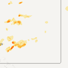
Hail Map for Thursday, July 14, 2011

Number of Impacted Households on 7/14/2011
0
Impacted by 1" or Larger Hail
0
Impacted by 1.75" or Larger Hail
0
Impacted by 2.5" or Larger Hail
Square Miles of Populated Area Impacted on 7/14/2011
0
Impacted by 1" or Larger Hail
0
Impacted by 1.75" or Larger Hail
0
Impacted by 2.5" or Larger Hail


Cities Most Affected by Hail Storms of 7/14/2011
| Hail Size | Demographics of Zip Codes Affected | ||||||
|---|---|---|---|---|---|---|---|
| City | Count | Average | Largest | Pop Density | House Value | Income | Age |
| Jordan, MT | 2 | 1.88 | 2.00 | 0 | $36k | $25.3k | 47.4 |
| Rosebud, MT | 2 | 1.75 | 1.75 | 0 | $83k | $31.3k | 45.5 |
| Meadow, SD | 1 | 2.00 | 2.00 | 0 | $31k | $19.7k | 43.8 |
| Prairie City, SD | 1 | 2.00 | 2.00 | 0 | $34k | $29.0k | 43.3 |
| Laurel, MT | 1 | 1.75 | 1.75 | 60 | $94k | $38.7k | 39.5 |
| Brandon, MN | 1 | 1.75 | 1.75 | 17 | $84k | $37.6k | 45.5 |
| Billings, MT | 1 | 1.75 | 1.75 | 75 | $81k | $26.8k | 34.8 |
Hail and Wind Damage Spotted on 7/14/2011
Filter by Report Type:Hail ReportsWind Reports
States Impacted
Montana, Alabama, Georgia, South Carolina, Colorado, Wyoming, Texas, South Dakota, Nebraska, New Mexico, North Dakota, MinnesotaMontana
| Local Time | Report Details |
|---|---|
| 1:26 PM UTC | Quarter sized hail reported near Butte, MT, 73.8 miles WNW of Bozeman, MT, trained spotter reported quarter size hail. |
| 8:30 PM UTC | Quarter sized hail reported near Ryegate, MT, 52.2 miles WNW of Billings, MT, a few 1 inch hail stones...lots of smaller hail. |
| 4:20 PM MDT | Golf Ball sized hail reported near Laurel, MT, 15.8 miles SW of Billings, MT, location estimated. passed on from billings dispatch. driver was on hwy 212 south of laurel. |
| 10:55 PM UTC | Ping Pong Ball sized hail reported near Billings, MT, 4.5 miles S of Billings, MT |
| 5:00 PM MDT | Golf Ball sized hail reported near Billings, MT, 2.3 miles SW of Billings, MT, location estimated. |
| 11:00 PM UTC | Location estimated. neighbors shop door ripped off...tree uprooted and powerline down in yar in yellowstone county MT, 31.7 miles NNE of Billings, MT |
| 11:11 PM UTC | Quarter sized hail reported near Billings, MT, 3.2 miles E of Billings, MT |
| 11:11 PM UTC | Ping Pong Ball sized hail reported near Billings, MT, 4.5 miles S of Billings, MT |
| 11:15 PM UTC | Storm survey. wet microburst caused crop and tree damage over 3 square miles. several dozen trees uprooted. winds estimated at 90 mp in yellowstone county MT, 16 miles NE of Billings, MT |
| 11:17 PM UTC | Quarter sized hail reported near Pompeys Pillar, MT, 31.2 miles ENE of Billings, MT |
| 12:05 AM UTC | Quarter sized hail reported near Hardin, MT, 43.3 miles E of Billings, MT, quarters and larger. |
| 12:10 AM UTC | Golf Ball sized hail reported near Jordan, MT, 62.6 miles SSW of Glasgow, MT, some quarter size hail mixed in along with heavy rain |
| 12:15 AM UTC | Quarter sized hail reported near Ingomar, MT, 66.3 miles NNE of Billings, MT, quarters early...downsized quickly. |
| 12:26 AM UTC | Quarter sized hail reported near Jordan, MT, 61.8 miles SSW of Glasgow, MT, and estimated 60 mph wind |
| 12:30 AM UTC | Storm damage reported in treasure county MT, 66.5 miles W of Miles City, MT |
| 12:40 AM UTC | Heavy rain also in phillips county MT, 45.2 miles WSW of Glasgow, MT |
| 12:43 AM UTC | Half Dollar sized hail reported near Hysham, MT, 66.5 miles W of Miles City, MT |
| 12:45 AM UTC | Quarter sized hail reported near Jordan, MT, 61.8 miles SSW of Glasgow, MT |
| 1:40 AM UTC | Hen Egg sized hail reported near Jordan, MT, 63.4 miles S of Glasgow, MT |
| 1:50 AM UTC | Golf Ball sized hail reported near Rosebud, MT, 51.9 miles SW of Miles City, MT |
| 2:05 AM UTC | Heavy rain in garfield county MT, 60.2 miles NNW of Miles City, MT |
| 2:20 AM UTC | Storm damage reported in mccone county MT, 63 miles SSE of Glasgow, MT |
| 2:55 AM UTC | Storm damage reported in mccone county MT, 71 miles N of Miles City, MT |
| 3:04 AM UTC | Quarter sized hail reported near Volborg, MT, 17.9 miles SE of Miles City, MT |
| 3:10 AM UTC | Golf Ball sized hail reported near Rosebud, MT, 55.1 miles WSW of Miles City, MT |
| 3:15 AM UTC | Pea size hail and heavy rain in valley county MT, 37.4 miles ENE of Glasgow, MT |
| 3:30 AM UTC | Heavy rain in roosevelt county MT, 41.7 miles ENE of Glasgow, MT |
| 3:40 AM UTC | Storm damage reported in dawson county MT, 57.2 miles NE of Miles City, MT |
| 3:55 AM UTC | Storm damage reported in daniels county MT, 69.4 miles NE of Glasgow, MT |
| 4:25 AM UTC | Storm damage reported in fallon county MT, 68.9 miles E of Miles City, MT |
| 4:45 AM UTC | Storm damage reported in wibaux county MT, 86.2 miles ENE of Miles City, MT |
| 4:50 AM UTC | Several tree branches with a diameter of 6 to 8 inches were across montana 480. the winds were rocking their truc in richland county MT, 62.3 miles WSW of Williston, ND |
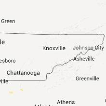
Alabama
| Local Time | Report Details |
|---|---|
| 6:00 PM UTC | Trees down along massey drive off of us 8 in russell county AL, 23.4 miles ESE of Auburn, AL |
| 6:30 PM UTC | Shed destroyed and 70 percent of roof off of a barn. also trees down...cattle trailer turned over...and porch ceiling destorye in winston county AL, 43.1 miles SSE of Florence, AL |
| 7:23 PM UTC | Power poles snapped at interstate 85 exit in montgomery county AL, 43.7 miles WSW of Auburn, AL |
| 7:28 PM UTC | Tree down on powerline along concord church r in talladega county AL, 35.6 miles E of Birmingham, AL |
| 7:30 PM UTC | Power lines down on eastchase parkwa in montgomery county AL, 43.1 miles WSW of Auburn, AL |
| 7:38 PM UTC | Roof partially peeled back on home under construction in the breckenridge subdivision. top of large hickory tree also snapped off in the same are in montgomery county AL, 43.3 miles WSW of Auburn, AL |
| 12:03 AM UTC | Trees down on power lines on mcmullen road near gurle in madison county AL, 64.8 miles WSW of Chattanooga, TN |
| 12:28 AM UTC | Metal roof peeled back several feet off barn...and doors were blown out. gates on the property blown dow in lawrence county AL, 40.3 miles SE of Florence, AL |
Georgia
| Local Time | Report Details |
|---|---|
| 6:34 PM UTC | Tree down on huckleberry lan in liberty county GA, 34.6 miles WSW of Savannah, GA |
| 7:52 PM UTC | Several trees uprooted. a trampoline was blown onto a ca in ben hill county GA, 27.5 miles WNW of Douglas, GA |
| 7:52 PM UTC | Quarter sized hail reported near Fitzgerald, GA, 27.5 miles WNW of Douglas, GA |
| 8:35 PM UTC | Several trees down on church stree in lee county GA, 86.6 miles SE of Auburn, AL |
| 8:49 PM UTC | 1 tree down in schley county GA, 78.1 miles ESE of Auburn, AL |
| 8:50 PM UTC | 5 trees down and shingles blown off roo in schley county GA, 73 miles ESE of Auburn, AL |
| 8:50 PM UTC | Several trees down along highway 280 in sumter county GA, 79.5 miles WNW of Douglas, GA |
| 10:00 PM UTC | A couple trees down in southern berrien count in berrien county GA, 36.5 miles SW of Douglas, GA |
| 11:40 PM UTC | 5 trees down...near houston valley road and i-7 in whitfield county GA, 23.2 miles SE of Chattanooga, TN |
South Carolina
| Local Time | Report Details |
|---|---|
| 6:43 PM UTC | Trees and power lines down in park circle. time estimated by rada in charleston county SC, 24 miles S of Charleston, SC |
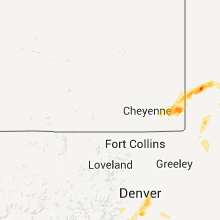
Colorado
| Local Time | Report Details |
|---|---|
| 2:47 PM MDT | Quarter sized hail reported near Highlands Ranch, CO, 13.2 miles S of Denver, CO |
| 8:55 PM UTC | 40 foot tree blown onto house and power lines near clarkson and lehig in arapahoe county CO, 6.2 miles S of Denver, CO |
| 3:05 PM MDT | Quarter sized hail reported near Englewood, CO, 11.6 miles SE of Denver, CO |
| 9:15 PM UTC | 50 foot tree blown over near hampton and broadway with 4 to 6 inches of standing water on nearby intersection in arapahoe county CO, 6.2 miles S of Denver, CO |
| 3:20 PM MDT | Quarter sized hail reported near Aurora, CO, 7.2 miles E of Denver, CO |
| 10:01 PM UTC | Storm damage reported in denver county CO, 19.3 miles ENE of Denver, CO |
Wyoming
| Local Time | Report Details |
|---|---|
| 9:57 PM UTC | Storm damage reported in big horn county WY, 92 miles SSE of Billings, MT |
| 10:00 PM UTC | Quarter sized hail reported near Burns, WY, 58.8 miles SW of Scottsbluff, NE, the average hail was nichel size. the largest was hail quarer size at 350 pm. |
| 10:20 PM UTC | Quarter sized hail reported near Albin, WY, 38 miles SW of Scottsbluff, NE |
| 12:49 AM UTC | Quarter sized hail reported near Cheyenne, WY, 44.3 miles ESE of Laramie, WY |
| 12:57 AM UTC | Quarter sized hail reported near Cheyenne, WY, 44.3 miles ESE of Laramie, WY |
Texas
| Local Time | Report Details |
|---|---|
| 10:34 PM UTC | Trees reorted down in rye at intersection of highways 146 and 78 in liberty county TX, 59.9 miles NE of Houston, TX |
| 10:45 PM UTC | Trees reported down by hardin elementary school on highway 14 in liberty county TX, 48.8 miles NE of Houston, TX |
| 10:50 PM UTC | *** 1 inj *** one person was injured after a tree fell on top of his pickup truck he was driving. the incident happened on fm 2767 near barber roa in smith county TX, 76.4 miles NNW of Lufkin, TX |
| 11:33 PM UTC | 20 to 30 power poles were knocked down or damaged along sh17 in reeves county TX, 51.3 miles N of Alpine, TX |
South Dakota
| Local Time | Report Details |
|---|---|
| 11:15 PM UTC | Quarter sized hail reported near Reva, SD, 84.5 miles N of Rapid City, SD |
| 11:30 PM UTC | Quarter sized hail reported near Ludlow, SD, 120.8 miles N of Rapid City, SD |
| 11:30 PM UTC | High wind lasted for 5 to 10 minute in harding county SD, 120.8 miles N of Rapid City, SD |
| 12:10 AM UTC | Ping Pong Ball sized hail reported near Reva, SD, 110.2 miles N of Rapid City, SD |
| 12:30 AM UTC | Storm damage reported in perkins county SD, 111.7 miles N of Rapid City, SD |
| 12:30 AM UTC | Hen Egg sized hail reported near Prairie City, SD, 111.7 miles N of Rapid City, SD, much of the hail was flat in shape. |
| 1:30 AM UTC | Quarter sized hail reported near Prairie City, SD, 93 miles NNE of Rapid City, SD |
| 1:42 AM UTC | Half Dollar sized hail reported near Bison, SD, 92.2 miles NNE of Rapid City, SD, just a few hailstones. most dime size. |
| 1:42 AM UTC | Hen Egg sized hail reported near Meadow, SD, 101.4 miles NNE of Rapid City, SD, reported by sd school of mines storm chaser. larger hail may have fallen but was unable to get a measurement. |
| 2:20 AM UTC | Ping Pong Ball sized hail reported near Meadow, SD, 107.8 miles NW of Pierre, SD, 1 3/4 inches of rain so far |
| 2:30 AM UTC | Half Dollar sized hail reported near Dupree, SD, 101.4 miles NW of Pierre, SD, much of the hail was flat in shape |
| 3:30 AM UTC | Quarter sized hail reported near Isabel, SD, 88.8 miles NW of Pierre, SD, estimated 50-70 mph winds that layed corn down and bent over mature trees |
Nebraska
| Local Time | Report Details |
|---|---|
| 11:22 PM UTC | Quarter sized hail reported near Harrisburg, NE, 14.3 miles SE of Scottsbluff, NE |
| 2:45 AM UTC | Quarter sized hail reported near Hyannis, NE, 79 miles NW of North Platte, NE |
New Mexico
| Local Time | Report Details |
|---|---|
| 12:45 AM UTC | *** 1 fatal *** barn roof collapsed onto elderly man in chaves county NM, 12.3 miles SE of Roswell, NM |
North Dakota
| Local Time | Report Details |
|---|---|
| 6:05 AM UTC | Storm damage reported in foster county ND, 47.7 miles SSW of Devils Lake, ND |
| 6:45 AM UTC | Along highway 200. zero visibility from heavy rain as wel in dunn county ND, 78.4 miles SW of Minot, ND |
| 8:15 AM UTC | Numerous tree branches 3 to 4 inches in diameter on ground around tow in barnes county ND, 67.7 miles SSE of Devils Lake, ND |
| 8:45 AM UTC | Numerous reports of tree branches and powerlines down around tow in barnes county ND, 58.2 miles W of Fargo, ND |
| 9:05 AM UTC | Quarter sized hail reported near McLeod, ND, 41.6 miles SW of Fargo, ND, nickel to quarter sized hail was reported by multiple sources and occurred mainly between 405 and 410 am cdt. |
| 9:40 AM UTC | Half Dollar sized hail reported near Colfax, ND, 32.1 miles S of Fargo, ND |
| 10:00 AM UTC | Several 3 to 5 inch tree branches were broken down in a a shelter bel in cass county ND, 8.8 miles SW of Fargo, ND |
| 10:20 AM UTC | Numerous large tree branches and limbs were broken down by winds. sporadic power outages were also observe in richland county ND, 41.3 miles SSE of Fargo, ND |
Minnesota
| Local Time | Report Details |
|---|---|
| 10:15 AM UTC | Golf Ball sized hail reported near Brandon, MN, 67.8 miles N of Montevideo, MN |
| 11:25 AM UTC | Half Dollar sized hail reported near Milbank, MN, 60.6 miles SSE of Fargo, ND, very heavy rain and a few quarter to half dollar sized hail stones. |
| 11:30 AM UTC | A power pole was broken down by falling tree limbs causing widepsread power outages in northwest lawrence townshi in grant county MN, 66.4 miles SSE of Fargo, ND |
| 11:32 AM UTC | Quarter sized hail reported near Wendell, MN, 66.3 miles SSE of Fargo, ND |
Connect with Interactive Hail Maps