

Hail Map for Monday, July 16, 2018

Number of Impacted Households on 7/16/2018
0
Impacted by 1" or Larger Hail
0
Impacted by 1.75" or Larger Hail
0
Impacted by 2.5" or Larger Hail
Square Miles of Populated Area Impacted on 7/16/2018
0
Impacted by 1" or Larger Hail
0
Impacted by 1.75" or Larger Hail
0
Impacted by 2.5" or Larger Hail


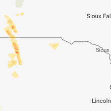
Cities Most Affected by Hail Storms of 7/16/2018
| Hail Size | Demographics of Zip Codes Affected | ||||||
|---|---|---|---|---|---|---|---|
| City | Count | Average | Largest | Pop Density | House Value | Income | Age |
| Hill City, SD | 1 | 1.75 | 1.75 | 3 | $97k | $36.2k | 47.3 |
Hail and Wind Damage Spotted on 7/16/2018
Filter by Report Type:Hail ReportsWind Reports
States Impacted
Tennessee, Florida, Michigan, Arkansas, Nebraska, Missouri, Indiana, Mississippi, New York, Kentucky, Virginia, Kansas, Pennsylvania, South Dakota, ColoradoTennessee
| Local Time | Report Details |
|---|---|
| 7:09 AM CDT | A large tree fell on a fence and several branches were down along the natchez trac in lawrence county TN, 42.1 miles N of Florence, AL |
| 5:23 PM EDT | Couple of trees down near rutledge and to the northeast between rutledge and bean statio in grainger county TN, 32.7 miles NE of Knoxville, TN |
Florida
| Local Time | Report Details |
|---|---|
| 12:48 PM EDT | Florida state watch office relayed a report from the alachua county sheriffs office of a downed tree along state road 24 near the intesection of 91st street south that in alachua county FL, 69.5 miles SW of Jacksonville, FL |
Michigan
| Local Time | Report Details |
|---|---|
| 1:15 PM EDT | A few trees down in the area blocking roads. also a couple trees down across roads in the southern part of the county. time estimated from rada in isabella county MI, 71.3 miles NW of Flint, MI |
| 1:45 PM EDT | Quarter sized hail reported near Mikado, MI, 34 miles S of Alpena, MI, relayed report of quarter sized hail damaging garden. time estimated from radar. |
| 4:12 PM EDT | 20 inch diameter tree downed across milford r in oakland county MI, 21.1 miles S of Flint, MI |
| 4:14 PM EDT | Two trees downed and power lines down near the 5000 block of state r in st. clair county MI, 63.6 miles E of Flint, MI |
| 4:36 PM EDT | 59 mph wind gust measured at fort gratiot light statio in st. clair county MI, 64.1 miles E of Flint, MI |
| 9:20 PM EDT | Estimated 50-60 mph wind gus in oakland county MI, 26.8 miles SSE of Flint, MI |
Arkansas
| Local Time | Report Details |
|---|---|
| 1:30 PM CDT | Trees were blown down near the north shore of lake conwa in faulkner county AR, 20.4 miles N of Little Rock, AR |
| 2:40 PM CDT | Trees down and blocking the highway along ar-46 south near cr-4670. time estimated from rada in grant county AR, 35.9 miles SSW of Little Rock, AR |
| 3:10 PM CDT | Tree damage reported near holcomb elementary. photos relayed via broadcast media social media accoun in washington county AR, 48.8 miles NNE of Fort Smith, AR |
| 3:29 PM CDT | Spotter reports trees down near the intersection of lee springs road and providence roa in jefferson county AR, 38.7 miles S of Little Rock, AR |
| 3:35 PM CDT | Trees down along lowman roa in jefferson county AR, 43 miles SSE of Little Rock, AR |
| 3:40 PM CDT | Trees down and blocking the highway along ar-46 south near cr-4670. time estimated from rada in grant county AR, 35.9 miles SSW of Little Rock, AR |
Nebraska
| Local Time | Report Details |
|---|---|
| 1:55 PM CDT | Report of a 14 inch tree split in half. reports of power outages with downed power pole in cherry county NE, 0.3 miles S of Valentine, NE |
| 5:15 PM MDT | Sustain at 54mph in sheridan county NE, 83.9 miles W of Valentine, NE |
| 5:42 PM MDT | Estimated 70 mph wind gusts with storm. power is ou in sheridan county NE, 80.3 miles W of Valentine, NE |
| 5:56 PM MDT | Quarter sized hail reported near Hay Springs, NE, 80.4 miles NE of Scottsbluff, NE, pea to quarter size hail... lots of rain. |
| 7:04 PM CDT | Quarter sized hail reported near Valentine, NE, 0.3 miles S of Valentine, NE |
| 7:04 PM CDT | Storm damage reported in cherry county NE, 0.3 miles S of Valentine, NE |
| 7:04 PM CDT | Storm damage reported in cherry county NE, 0.3 miles S of Valentine, NE |
| 7:05 PM CDT | Mesonet station e3958... valentine 1 in cherry county NE, 0.6 miles NW of Valentine, NE |
| 7:07 PM CDT | Storm damage reported in cherry county NE, 0.3 miles S of Valentine, NE |
| 6:35 PM MDT | Three large trees down in town from strong winds in sheridan county NE, 83.9 miles W of Valentine, NE |
| 7:43 PM CDT | Wind estimated at 50 to 60 mp in cherry county NE, 14.2 miles SE of Valentine, NE |
| 8:19 PM CDT | Quarter sized hail reported near Wood Lake, NE, 24.4 miles SSE of Valentine, NE |
| 11:24 PM CDT | Storm damage reported in thomas county NE, 59.1 miles N of North Platte, NE |
| 10:30 PM MDT | Large tree limbs down in melbeta. report received via twitte in scotts bluff county NE, 9.3 miles SE of Scottsbluff, NE |
| 11:35 PM CDT | Winds gusting to 58 mph or higher since 1124 pm in thomas county NE, 59.1 miles N of North Platte, NE |
Missouri
| Local Time | Report Details |
|---|---|
| 2:00 PM CDT | Tree limbs down and pea sized hail in the mansfield area. pictures relayed by a amateur radio operator. time approximate based on rada in wright county MO, 39.9 miles E of Springfield, MO |
| 2:15 PM CDT | Severe thunderstorm wind gusts damaged trees and some power pole in polk county MO, 17.4 miles N of Springfield, MO |
| 4:04 PM CDT | Severe thunderstorm wind gusts damaged a sign and some awning panels at a gas statio in howell county MO, 56.8 miles SSW of Salem, MO |
| 6:25 PM CDT | Spotter went around town. saw several limbs down. some power outages. one tree down. trucking business on the west side of town had damage to its windows and a doo in stoddard county MO, 24.5 miles SW of Cape Girardeau, MO |
Indiana
| Local Time | Report Details |
|---|---|
| 3:15 PM EDT | Fiber optic line dow in huntington county IN, 23.7 miles WSW of Fort Wayne, IN |
Mississippi
| Local Time | Report Details |
|---|---|
| 2:58 PM CDT | Tree down along ridge road on the west side of chunky. winds were sub-sever in newton county MS, 72 miles E of Jackson, MS |
| 3:49 PM CDT | Tree down along hwy 43 n. estimated sub-severe win in attala county MS, 50.2 miles WSW of Starkville, MS |
| 3:52 PM CDT | Tree down along hwy 440 near the lighthouse children's home. estimated sub-severe win in attala county MS, 54.2 miles WSW of Starkville, MS |
| 4:21 PM CDT | Tree down along hwy 12 wes in attala county MS, 57.3 miles NNE of Jackson, MS |
| 5:15 PM CDT | A sailboat on ross barnett reservoir was damaged. two occupants were in distress but were not injure in madison county MS, 10.2 miles NE of Jackson, MS |
| 5:52 PM CDT | Tree down across the roa in madison county MS, 12.5 miles N of Jackson, MS |
| 6:06 PM CDT | Multiple trees blown down across the city of ridgelan in madison county MS, 9.5 miles NNE of Jackson, MS |
| 6:45 PM CDT | Trees and power lines down near the intersection of lower water bridge rd and bogue chitto r in franklin county MS, 67.7 miles SSW of Jackson, MS |
| 8:20 PM CDT | Multiple trees down across the southern portion of the count in warren county MS, 45.2 miles WSW of Jackson, MS |
New York
| Local Time | Report Details |
|---|---|
| 4:02 PM EDT | Tree and wires down on peak road in ulster county NY, 64.8 miles S of Schenectady, NY |
| 4:14 PM EDT | Tree and wires downed at the intersection of tongore road and bogart lane in ulster county NY, 65.8 miles S of Schenectady, NY |
| 4:18 PM EDT | Tree downed on wires on marcott road in ulster county NY, 64.9 miles S of Schenectady, NY |
| 4:36 PM EDT | Wire down on garland av in monroe county NY, 66.7 miles ENE of Buffalo, NY |
| 4:37 PM EDT | Wires down on maple s in monroe county NY, 66.7 miles ENE of Buffalo, NY |
| 4:40 PM EDT | Wires down on campbell stree in monroe county NY, 66.7 miles ENE of Buffalo, NY |
| 4:45 PM EDT | Tree down onto a hous in monroe county NY, 66.7 miles ENE of Buffalo, NY |
| 5:20 PM EDT | Tree down on clark r in wayne county NY, 47.7 miles W of Syracuse, NY |
| 5:20 PM EDT | Tree on hous in wayne county NY, 46.7 miles W of Syracuse, NY |
| 5:20 PM EDT | Tree on hous in wayne county NY, 46.7 miles W of Syracuse, NY |
| 5:58 PM EDT | Trees and wires down on catchpole roa in wayne county NY, 37.7 miles W of Syracuse, NY |
| 7:00 PM EDT | Multiple reports of trees and wires down moravia... west niles and new hope area in cayuga county NY, 27.2 miles SSW of Syracuse, NY |
| 8:15 PM EDT | Tree down on lee center taberg roa in oneida county NY, 35.1 miles ENE of Syracuse, NY |
| 8:15 PM EDT | Tree down on coal hill roa in oneida county NY, 33 miles ENE of Syracuse, NY |
| 8:30 PM EDT | Tree down on jervis ave near cemetar in oneida county NY, 35.5 miles ENE of Syracuse, NY |
| 8:40 PM EDT | Tree down on coombs road near hughes roa in oneida county NY, 51.4 miles ENE of Syracuse, NY |
| 8:55 PM EDT | Trees dow in chautauqua county NY, 57.3 miles SSW of Buffalo, NY |
| 10:02 PM EDT | Tree down on harlow rd in genesee county NY, 22.8 miles E of Buffalo, NY |
Kentucky
| Local Time | Report Details |
|---|---|
| 4:31 PM EDT | Large tree branch down near the intersection of logan barnes road and highway 1546. relayed via twitte in wayne county KY, 82.6 miles SW of Irvine, KY |
Virginia
| Local Time | Report Details |
|---|---|
| 4:55 PM EDT | Tree reported down in the montpelier area in orange county VA, 57.8 miles NNW of Richmond, VA |
| 5:26 PM EDT | Tree reported down in unionville area in orange county VA, 55 miles NNW of Richmond, VA |
| 5:39 PM EDT | Two reports of trees downed in the mine run/locust grove section of the county in orange county VA, 53.2 miles N of Richmond, VA |
| 5:48 PM EDT | Several trees down on and around house at 257 dixie airport road. time estimated from rada in amherst county VA, 47.9 miles ENE of Roanoke, VA |
Kansas
| Local Time | Report Details |
|---|---|
| 5:15 PM CDT | Quarter sized hail reported near Girard, KS, 37.2 miles ESE of Chanute, KS, quarter-sized hail estimated near crawford hills golf course; delayed report. |
| 5:40 PM CDT | Severe thunderstorm wind gusts downed several limbs at the girard municipal golf cours in crawford county KS, 36.6 miles ESE of Chanute, KS |
| 5:40 PM CDT | Quarter sized hail reported near Girard, KS, 37.2 miles ESE of Chanute, KS, corrects previous hail report from 1 e girard. quarter-sized hail estimated near crawford hills golf course; delayed report. |
Pennsylvania
| Local Time | Report Details |
|---|---|
| 6:22 PM EDT | A few downed trees and power lines... one of which fell on a vehicle on the 800 block of gill hollow r in cambria county PA, 33.4 miles W of State College, PA |
| 6:47 PM EDT | Numerous trees down across the cit in crawford county PA, 80.5 miles E of Cleveland, OH |
| 8:02 PM EDT | 1 tree down at intersection of route 27 and enterprise rd in warren county PA, 85.2 miles NNE of Pittsburgh, PA |
| 8:35 PM EDT | Uprooted tree near the intersection of tower lane and campbell hill rd in warren county PA, 88.1 miles SSW of Buffalo, NY |
| 8:40 PM EDT | Tree down on the 4700 block of davey hill rd in warren county PA, 80.2 miles SSW of Buffalo, NY |
| 8:45 PM EDT | Several limbs down in the 2400 block of mathews run rd in warren county PA, 73.3 miles SSW of Buffalo, NY |
| 10:15 PM EDT | Tree down on 700 block of lower arnot rd in blossburg township in tioga county PA, 71.2 miles NNE of State College, PA |
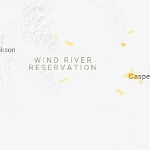
South Dakota
| Local Time | Report Details |
|---|---|
| 4:25 PM MDT | Ping Pong Ball sized hail reported near Custer, SD, 27.9 miles SSW of Rapid City, SD |
| 4:35 PM MDT | Quarter sized hail reported near Hill City, SD, 22.7 miles SW of Rapid City, SD, delayed report. time estimated from radar. spotter la33. |
| 4:36 PM MDT | Golf Ball sized hail reported near Hill City, SD, 23.2 miles SW of Rapid City, SD, delayed report. time estimated from radar. spotter la33. |
| 6:05 PM CDT | Storm damage reported in todd county SD, 24.1 miles NNW of Valentine, NE |
| 6:10 PM CDT | Storm damage reported in todd county SD, 24.1 miles NNW of Valentine, NE |
| 6:57 PM CDT | Storm damage reported in todd county SD, 30.1 miles N of Valentine, NE |
Colorado
| Local Time | Report Details |
|---|---|
| 7:32 PM MDT | Quarter sized hail reported near Parker, CO, 17.9 miles SE of Denver, CO |
| 7:33 PM MDT | Quarter sized hail reported near Parker, CO, 18 miles SE of Denver, CO |
Connect with Interactive Hail Maps