

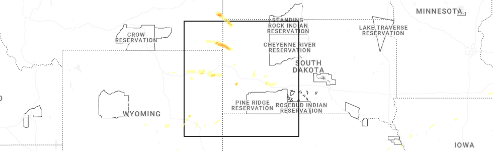
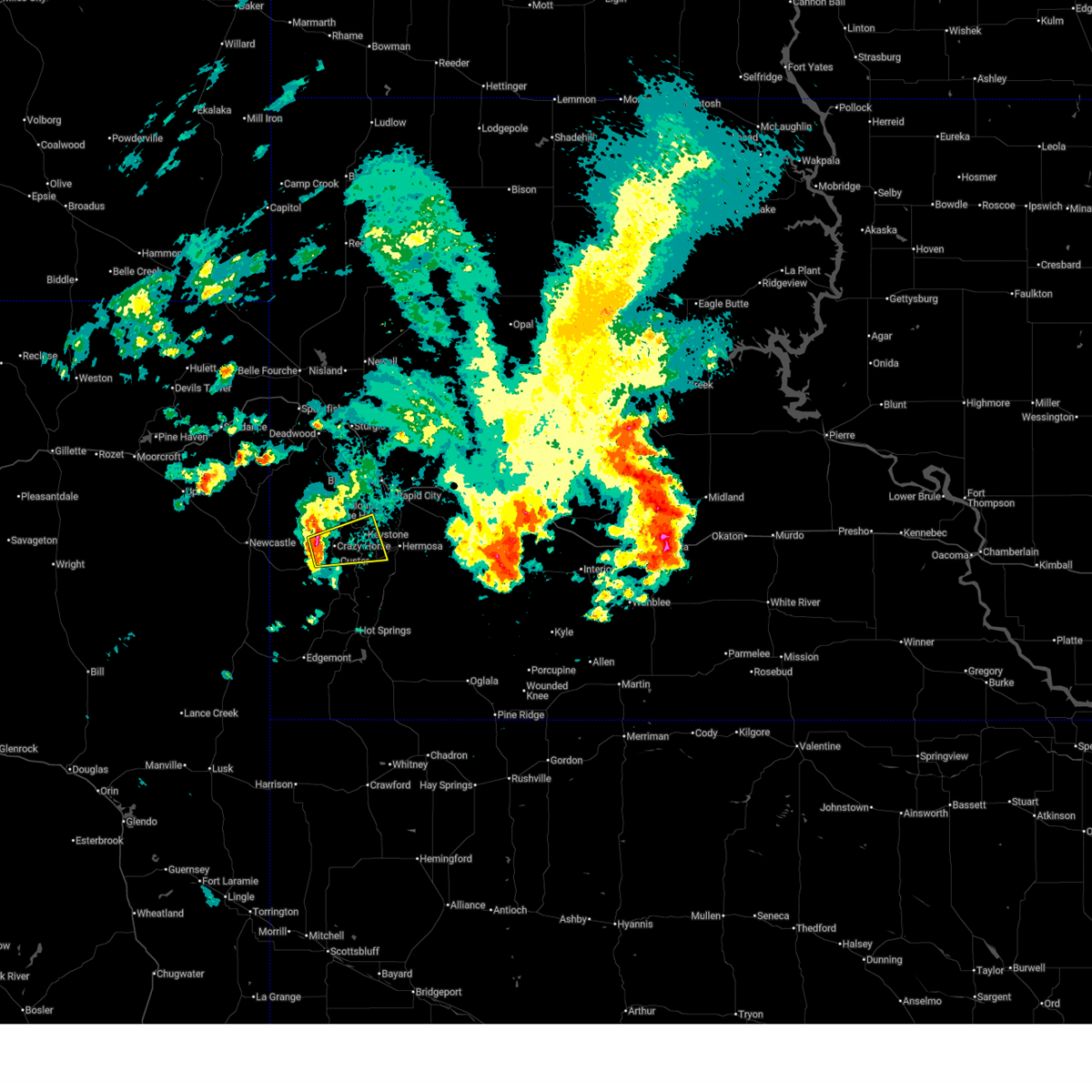
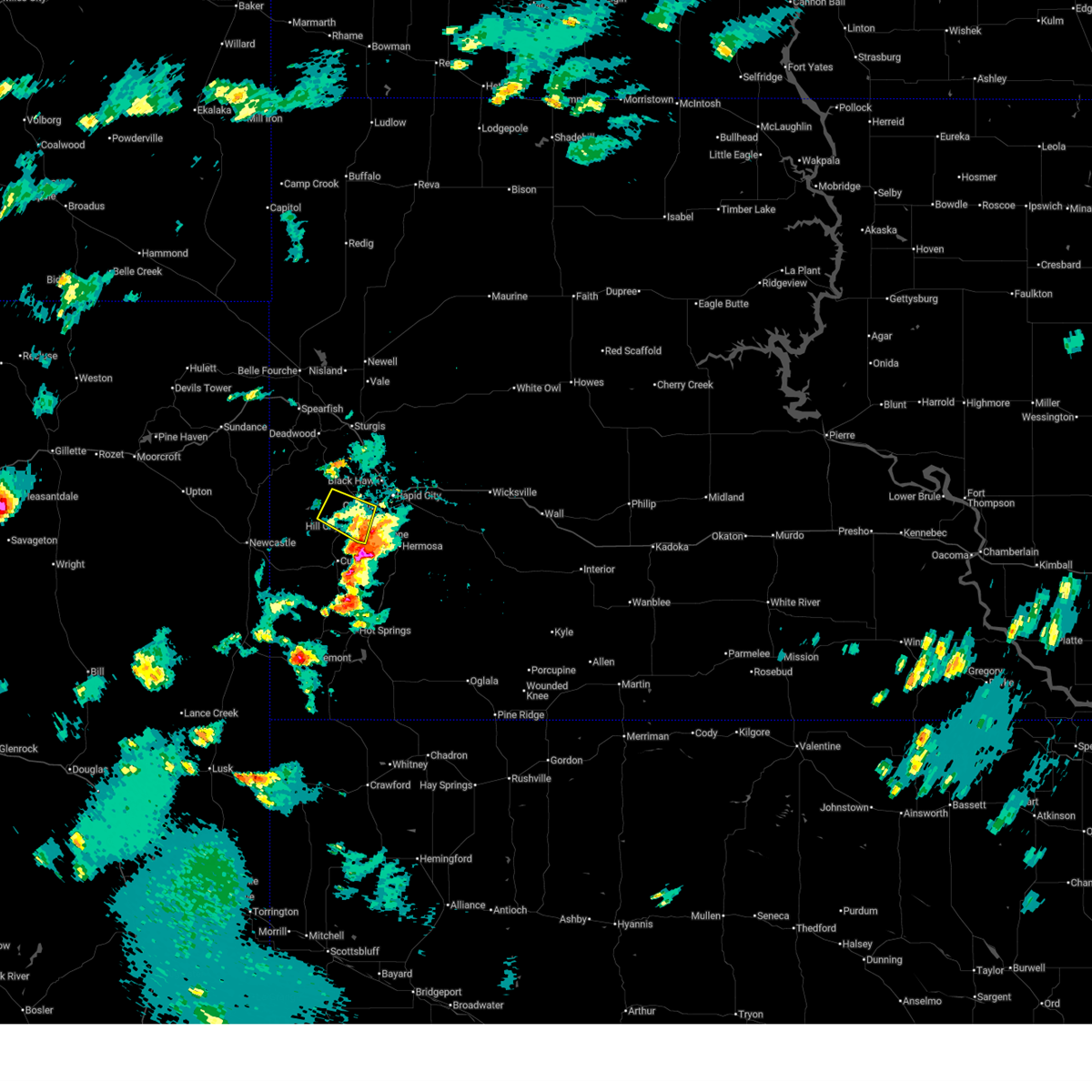
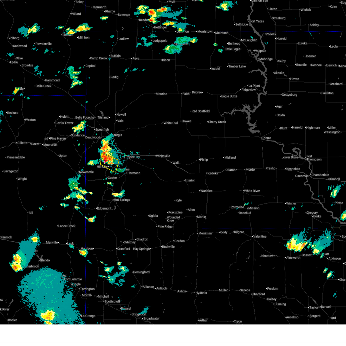
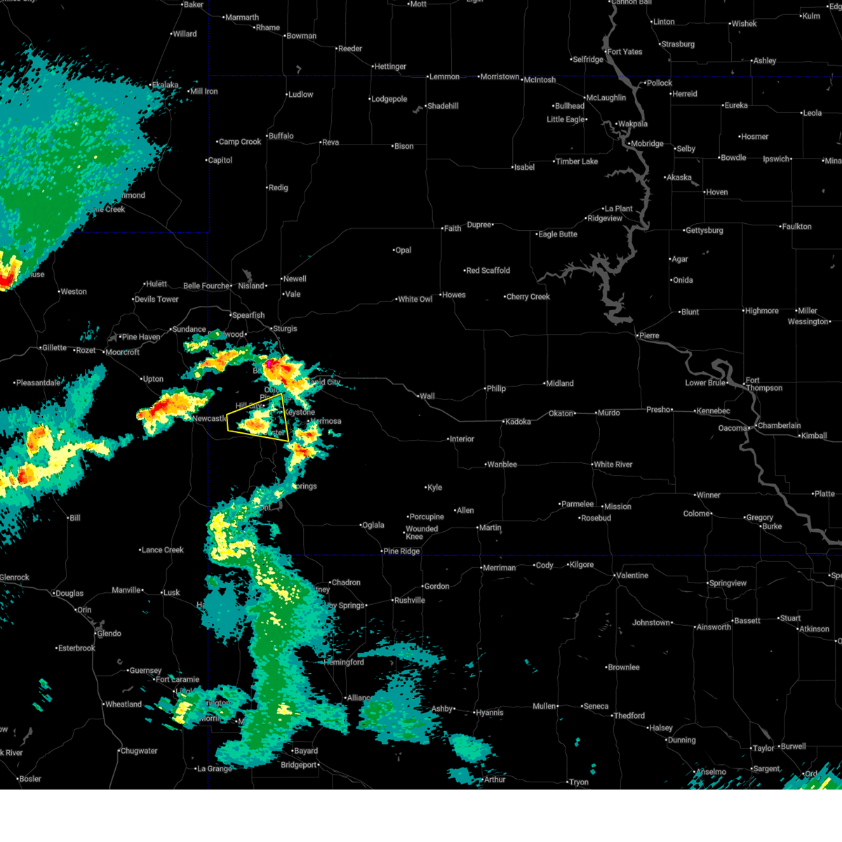
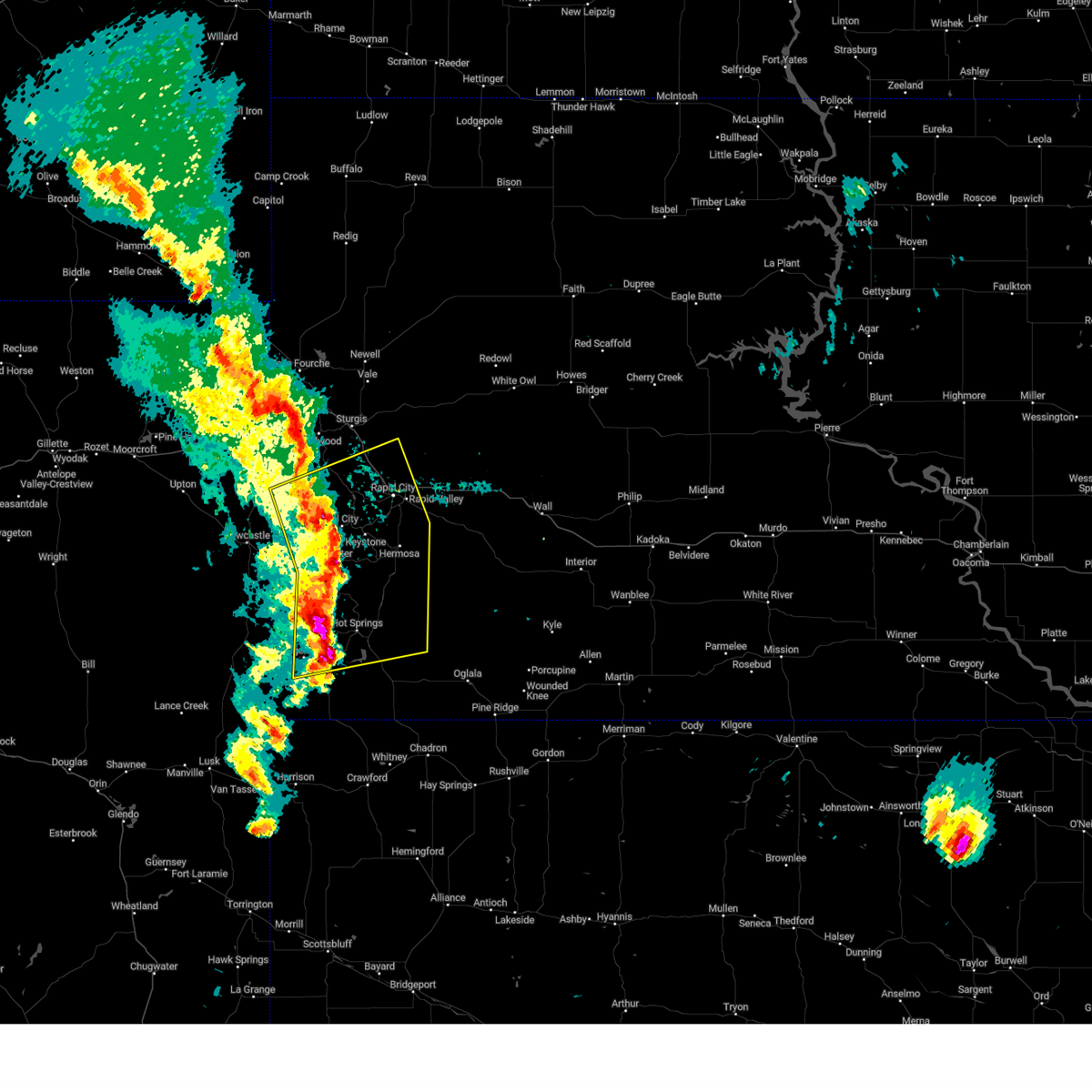
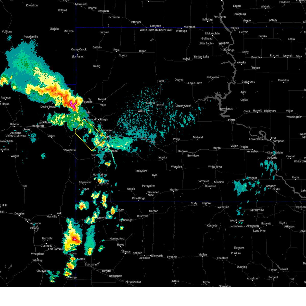
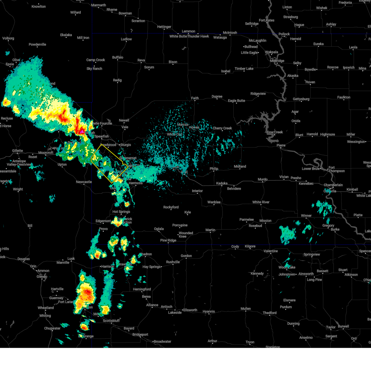
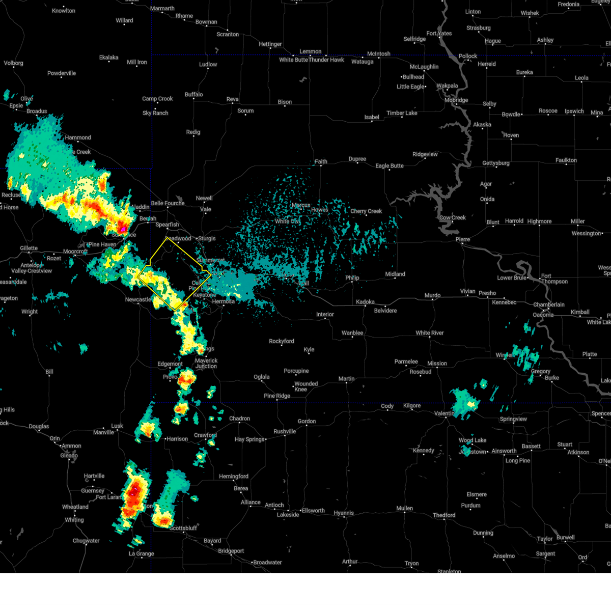
Hail Map for Hill City, SD
The Hill City, SD area has had 88 reports of on-the-ground hail by trained spotters, and has been under severe weather warnings 16 times during the past 12 months. Doppler radar has detected hail at or near Hill City, SD on 127 occasions, including 7 occasions during the past year.
| Name: | Hill City, SD |
| Where Located: | 19.6 miles WSW of Rapid City, SD |
| Map: | Google Map for Hill City, SD |
| Population: | 948 |
| Housing Units: | 473 |
| More Info: | Search Google for Hill City, SD |
1
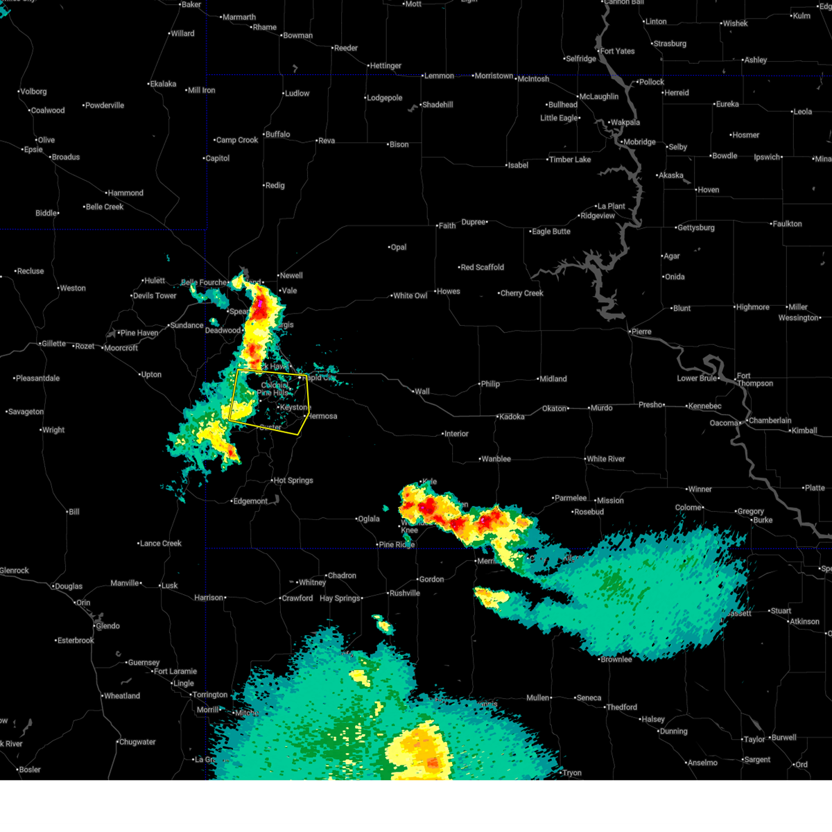
The Top Recent Hail Date for Hill City, SD is Wednesday, June 25, 2025 (46th out of 127)
Hail and Wind Damage Spotted near Hill City, SD
| Date / Time | Report Details |
|---|---|
| 7/7/2025 3:51 PM MDT |
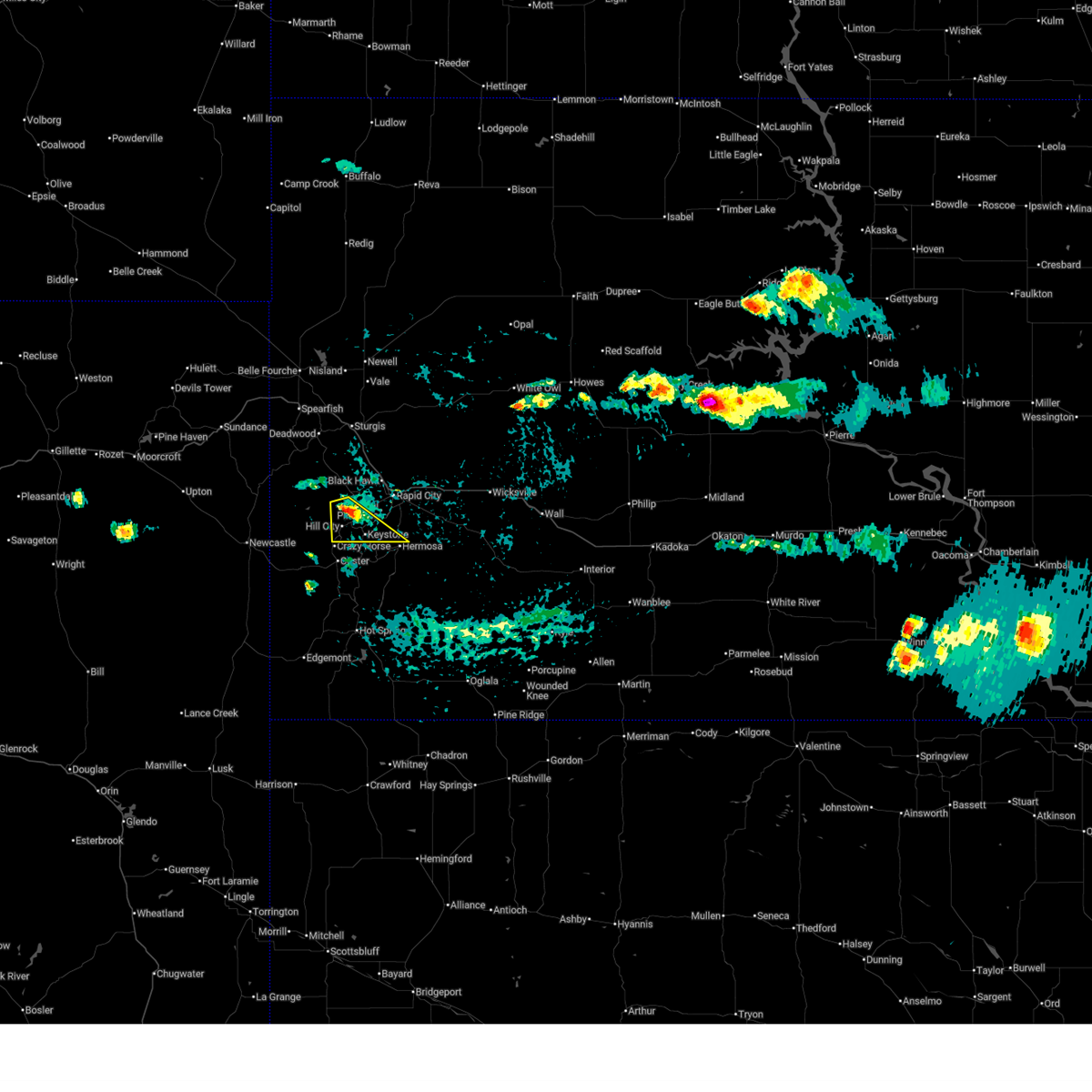 the severe thunderstorm warning has been cancelled and is no longer in effect the severe thunderstorm warning has been cancelled and is no longer in effect
|
| 7/7/2025 3:36 PM MDT |
 At 336 pm mdt, a severe thunderstorm was located 4 miles south of silver city, or 6 miles north of hill city, moving southeast at 15 mph (radar indicated). Hazards include quarter size hail. Damage to vehicles is expected. Locations impacted include, hill city, keystone, hayward, rockerville, mount rushmore national memorial, sheridan lake, keystone wye, black elk peak, horse thief lake, and palmer gulch resort. At 336 pm mdt, a severe thunderstorm was located 4 miles south of silver city, or 6 miles north of hill city, moving southeast at 15 mph (radar indicated). Hazards include quarter size hail. Damage to vehicles is expected. Locations impacted include, hill city, keystone, hayward, rockerville, mount rushmore national memorial, sheridan lake, keystone wye, black elk peak, horse thief lake, and palmer gulch resort.
|
| 7/7/2025 3:29 PM MDT |
 Svrunr the national weather service in rapid city has issued a * severe thunderstorm warning for, southwestern pennington county in west central south dakota, * until 430 pm mdt. * at 328 pm mdt, a severe thunderstorm was located over mystic, or 8 miles north of hill city, moving southeast at 15 mph (radar indicated). Hazards include half dollar size hail. damage to vehicles is expected Svrunr the national weather service in rapid city has issued a * severe thunderstorm warning for, southwestern pennington county in west central south dakota, * until 430 pm mdt. * at 328 pm mdt, a severe thunderstorm was located over mystic, or 8 miles north of hill city, moving southeast at 15 mph (radar indicated). Hazards include half dollar size hail. damage to vehicles is expected
|
| 7/5/2025 11:24 PM MDT |
 Svrunr the national weather service in rapid city has issued a * severe thunderstorm warning for, north central custer county in southwestern south dakota, western pennington county in west central south dakota, * until midnight mdt. * at 1123 pm mdt, a severe thunderstorm was located near bear mountain lookout, or 8 miles northwest of custer, moving east at 35 mph (radar indicated). Hazards include half dollar size hail. damage to vehicles is expected Svrunr the national weather service in rapid city has issued a * severe thunderstorm warning for, north central custer county in southwestern south dakota, western pennington county in west central south dakota, * until midnight mdt. * at 1123 pm mdt, a severe thunderstorm was located near bear mountain lookout, or 8 miles northwest of custer, moving east at 35 mph (radar indicated). Hazards include half dollar size hail. damage to vehicles is expected
|
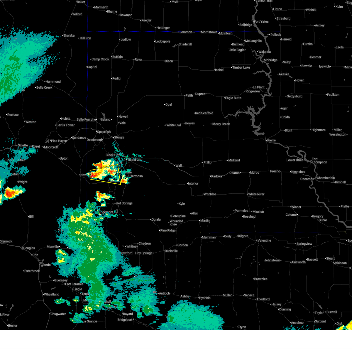
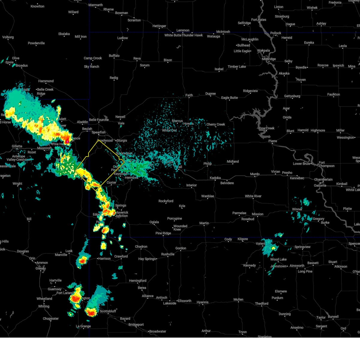
| 6/25/2025 4:40 PM MDT | Svrunr the national weather service in rapid city has issued a * severe thunderstorm warning for, south central pennington county in west central south dakota, * until 545 pm mdt. * at 439 pm mdt, a severe thunderstorm was located near sheridan lake, or 3 miles east of hill city, moving east at 15 mph (radar indicated). Hazards include half dollar size hail. damage to vehicles is expected |
| 6/17/2025 2:18 PM MDT |
 the severe thunderstorm warning has been cancelled and is no longer in effect the severe thunderstorm warning has been cancelled and is no longer in effect
|
| 6/17/2025 1:47 PM MDT | At 147 pm mdt, a severe thunderstorm was located 4 miles north of hill city, moving southeast at 15 mph (radar indicated). Hazards include quarter size hail. Damage to vehicles is expected. Locations impacted include, hill city, keystone, horse thief lake, keystone wye, mount rushmore national memorial, palmer gulch resort, pactola reservoir and sheridan lake. |
| 6/17/2025 1:32 PM MDT | Half Dollar sized hail reported 7.3 miles SE of Hill City, SD, a lot of pea sized hail... also. |
| 6/17/2025 1:31 PM MDT |
 Svrunr the national weather service in rapid city has issued a * severe thunderstorm warning for, southwestern pennington county in west central south dakota, * until 230 pm mdt. * at 131 pm mdt, a severe thunderstorm was located 3 miles south of mystic, or 7 miles northwest of hill city, moving southeast at 15 mph (radar indicated). Hazards include quarter size hail. Damage to vehicles is expected. this severe thunderstorm will be near, hill city, silver city, horse thief lake, keystone wye, mount rushmore national memorial, palmer gulch resort, pactola reservoir, and sheridan lake around 135 pm mdt. Keystone around 140 pm mdt. Svrunr the national weather service in rapid city has issued a * severe thunderstorm warning for, southwestern pennington county in west central south dakota, * until 230 pm mdt. * at 131 pm mdt, a severe thunderstorm was located 3 miles south of mystic, or 7 miles northwest of hill city, moving southeast at 15 mph (radar indicated). Hazards include quarter size hail. Damage to vehicles is expected. this severe thunderstorm will be near, hill city, silver city, horse thief lake, keystone wye, mount rushmore national memorial, palmer gulch resort, pactola reservoir, and sheridan lake around 135 pm mdt. Keystone around 140 pm mdt.
|
| 6/16/2025 8:02 PM MDT |
 the severe thunderstorm warning has been cancelled and is no longer in effect the severe thunderstorm warning has been cancelled and is no longer in effect
|
| 6/16/2025 7:40 PM MDT | At 740 pm mdt, a severe thunderstorm was located 3 miles south of bear mountain lookout, or 7 miles northwest of custer, moving east at 20 mph (radar indicated). Hazards include 60 mph wind gusts and quarter size hail. Hail damage to vehicles is expected. expect wind damage to roofs, siding, and trees. Locations impacted include, custer, hill city, horse thief lake, stockade lake, mount rushmore national memorial, legion lake, palmer gulch resort, crazy horse memorial, sylvan lake, mount coolidge, keystone, center lake, keystone wye, black hills playhouse, state game lodge and sheridan lake. |
| 6/16/2025 7:20 PM MDT |
 Svrunr the national weather service in rapid city has issued a * severe thunderstorm warning for, northwestern custer county in southwestern south dakota, southwestern pennington county in west central south dakota, * until 815 pm mdt. * at 719 pm mdt, a severe thunderstorm was located 6 miles southwest of bear mountain lookout, or 14 miles west of custer, moving east at 20 mph (radar indicated). Hazards include ping pong ball size hail and 60 mph wind gusts. People and animals outdoors will be injured. expect hail damage to roofs, siding, windows, and vehicles. expect wind damage to roofs, siding, and trees. this severe thunderstorm will be near, custer, bear mountain lookout, crazy horse memorial, medicine mountain, and custer state park around 725 pm mdt. hill city, sylvan lake, and black elk peak around 730 pm mdt. palmer gulch resort around 735 pm mdt. Other locations in the path of this severe thunderstorm include horse thief lake, stockade lake, mount rushmore national memorial, legion lake, mount coolidge and sheridan lake. Svrunr the national weather service in rapid city has issued a * severe thunderstorm warning for, northwestern custer county in southwestern south dakota, southwestern pennington county in west central south dakota, * until 815 pm mdt. * at 719 pm mdt, a severe thunderstorm was located 6 miles southwest of bear mountain lookout, or 14 miles west of custer, moving east at 20 mph (radar indicated). Hazards include ping pong ball size hail and 60 mph wind gusts. People and animals outdoors will be injured. expect hail damage to roofs, siding, windows, and vehicles. expect wind damage to roofs, siding, and trees. this severe thunderstorm will be near, custer, bear mountain lookout, crazy horse memorial, medicine mountain, and custer state park around 725 pm mdt. hill city, sylvan lake, and black elk peak around 730 pm mdt. palmer gulch resort around 735 pm mdt. Other locations in the path of this severe thunderstorm include horse thief lake, stockade lake, mount rushmore national memorial, legion lake, mount coolidge and sheridan lake.
|
| 6/15/2025 8:10 PM MDT | Storm damage reported in pennington county SD, 0.3 miles NNE of Hill City, SD |
| 6/15/2025 8:08 PM MDT | At 808 pm mdt, severe thunderstorms were located along a line extending from pactola reservoir to horse thief lake to near custer, moving east at 25 mph (radar indicated). Hazards include 60 mph wind gusts. Expect damage to roofs, siding, and trees. These severe storms will be near, rapid city, southwestern rapid valley, johnson siding, hermosa, keystone, hisega, hayward, rockerville, center lake, and hart ranch around 815 pm mdt. |
| 6/15/2025 8:00 PM MDT | Storm damage reported in pennington county SD, 0.7 miles ENE of Hill City, SD |
| 6/15/2025 7:57 PM MDT |
 At 756 pm mdt, severe thunderstorms were located along a line extending from near silver city to near palmer gulch resort to 3 miles southwest of crazy horse memorial, moving east at 30 mph (radar indicated). Hazards include 60 mph wind gusts. Expect damage to roofs, siding, and trees. these severe storms will be near, rapid city, custer, hill city, johnson siding, keystone, silver city, hisega, hayward, rockerville, and center lake around 800 pm mdt. reptile gardens around 805 pm mdt. Other locations in the path of these severe thunderstorms include hart ranch, southwestern rapid valley, hermosa and black gap. At 756 pm mdt, severe thunderstorms were located along a line extending from near silver city to near palmer gulch resort to 3 miles southwest of crazy horse memorial, moving east at 30 mph (radar indicated). Hazards include 60 mph wind gusts. Expect damage to roofs, siding, and trees. these severe storms will be near, rapid city, custer, hill city, johnson siding, keystone, silver city, hisega, hayward, rockerville, and center lake around 800 pm mdt. reptile gardens around 805 pm mdt. Other locations in the path of these severe thunderstorms include hart ranch, southwestern rapid valley, hermosa and black gap.
|
| 6/15/2025 7:45 PM MDT |
 Svrunr the national weather service in rapid city has issued a * severe thunderstorm warning for, northwestern custer county in southwestern south dakota, southwestern pennington county in west central south dakota, * until 845 pm mdt. * at 745 pm mdt, severe thunderstorms were located along a line extending from near rochford to near medicine mountain to 2 miles northeast of jewel cave national monument, moving east at 25 mph (radar indicated). Hazards include 60 mph wind gusts. Expect damage to roofs, siding, and trees. severe thunderstorms will be near, custer, hill city, johnson siding, keystone, silver city, hisega, mystic, center lake, horse thief lake, and stockade lake around 750 pm mdt. hayward and rockerville around 755 pm mdt. rapid city, state game lodge, and bear country around 800 pm mdt. reptile gardens around 805 pm mdt. Other locations in the path of these severe thunderstorms include hart ranch, western rapid valley, hermosa and black gap. Svrunr the national weather service in rapid city has issued a * severe thunderstorm warning for, northwestern custer county in southwestern south dakota, southwestern pennington county in west central south dakota, * until 845 pm mdt. * at 745 pm mdt, severe thunderstorms were located along a line extending from near rochford to near medicine mountain to 2 miles northeast of jewel cave national monument, moving east at 25 mph (radar indicated). Hazards include 60 mph wind gusts. Expect damage to roofs, siding, and trees. severe thunderstorms will be near, custer, hill city, johnson siding, keystone, silver city, hisega, mystic, center lake, horse thief lake, and stockade lake around 750 pm mdt. hayward and rockerville around 755 pm mdt. rapid city, state game lodge, and bear country around 800 pm mdt. reptile gardens around 805 pm mdt. Other locations in the path of these severe thunderstorms include hart ranch, western rapid valley, hermosa and black gap.
|
| 4/27/2025 8:15 PM MDT | Golf Ball sized hail reported 7.3 miles SE of Hill City, SD |
| 4/27/2025 7:47 PM MDT | Ping Pong Ball sized hail reported 13.1 miles S of Hill City, SD |
| 8/26/2024 3:35 PM MDT |
 At 335 pm mdt, severe thunderstorms were located along a line extending from near nemo to near hayward to 2 miles south of maverick junction, moving northeast at 45 mph (radar indicated). Hazards include 70 mph wind gusts and quarter size hail. Hail damage to vehicles is expected. expect considerable tree damage. wind damage is also likely to mobile homes, roofs, and outbuildings. locations impacted include, rapid city, rapid valley, southwestern box elder, black hawk, summerset, hermosa, piedmont, oral, buffalo gap, hisega and ellsworth air force base. This includes interstate 90 in south dakota between mile markers 42 and 65. At 335 pm mdt, severe thunderstorms were located along a line extending from near nemo to near hayward to 2 miles south of maverick junction, moving northeast at 45 mph (radar indicated). Hazards include 70 mph wind gusts and quarter size hail. Hail damage to vehicles is expected. expect considerable tree damage. wind damage is also likely to mobile homes, roofs, and outbuildings. locations impacted include, rapid city, rapid valley, southwestern box elder, black hawk, summerset, hermosa, piedmont, oral, buffalo gap, hisega and ellsworth air force base. This includes interstate 90 in south dakota between mile markers 42 and 65.
|
| 8/26/2024 3:10 PM MDT |
 Svrunr the national weather service in rapid city has issued a * severe thunderstorm warning for, southwestern meade county in west central south dakota, custer county in southwestern south dakota, southeastern lawrence county in west central south dakota, northern fall river county in southwestern south dakota, southwestern pennington county in west central south dakota, * until 415 pm mdt. * at 310 pm mdt, severe thunderstorms were located along a line extending from 2 miles north of flag mountain to 2 miles west of custer to 7 miles southwest of cascade falls, moving northeast at 40 mph (radar indicated). Hazards include 70 mph wind gusts and quarter size hail. Hail damage to vehicles is expected. expect considerable tree damage. wind damage is also likely to mobile homes, roofs, and outbuildings. severe thunderstorms will be near, hot springs, custer, hill city, nemo, keystone, pringle, silver city, rochford, argyle, and mystic around 315 pm mdt. johnson siding, buffalo gap, hisega, hayward, rockerville, and dalton lake around 320 pm mdt. rapid city, black hawk, summerset, hermosa, piedmont, oral, fairburn, bear country, and reptile gardens around 325 pm mdt. smithwick, hart ranch, and black gap around 330 pm mdt. other locations in the path of these severe thunderstorms include rapid valley, ellsworth air force base, southwestern box elder and rapid city airport. This includes interstate 90 in south dakota between mile markers 42 and 65. Svrunr the national weather service in rapid city has issued a * severe thunderstorm warning for, southwestern meade county in west central south dakota, custer county in southwestern south dakota, southeastern lawrence county in west central south dakota, northern fall river county in southwestern south dakota, southwestern pennington county in west central south dakota, * until 415 pm mdt. * at 310 pm mdt, severe thunderstorms were located along a line extending from 2 miles north of flag mountain to 2 miles west of custer to 7 miles southwest of cascade falls, moving northeast at 40 mph (radar indicated). Hazards include 70 mph wind gusts and quarter size hail. Hail damage to vehicles is expected. expect considerable tree damage. wind damage is also likely to mobile homes, roofs, and outbuildings. severe thunderstorms will be near, hot springs, custer, hill city, nemo, keystone, pringle, silver city, rochford, argyle, and mystic around 315 pm mdt. johnson siding, buffalo gap, hisega, hayward, rockerville, and dalton lake around 320 pm mdt. rapid city, black hawk, summerset, hermosa, piedmont, oral, fairburn, bear country, and reptile gardens around 325 pm mdt. smithwick, hart ranch, and black gap around 330 pm mdt. other locations in the path of these severe thunderstorms include rapid valley, ellsworth air force base, southwestern box elder and rapid city airport. This includes interstate 90 in south dakota between mile markers 42 and 65.
|
| 7/3/2024 4:19 PM MDT |
 At 418 pm mdt, a severe thunderstorm was located near mount rushmore national memorial, or 7 miles southeast of hill city, moving east at 30 mph. at 411 pm mdt, quarter sized hail was reported 3 miles south- southwest of hill city (public). Hazards include 60 mph wind gusts and quarter size hail. Hail damage to vehicles is expected. expect wind damage to roofs, siding, and trees. Locations impacted include, keystone, hayward, mount rushmore national memorial, black elk peak, sylvan lake, palmer gulch resort, horse thief lake, and northern custer state park. At 418 pm mdt, a severe thunderstorm was located near mount rushmore national memorial, or 7 miles southeast of hill city, moving east at 30 mph. at 411 pm mdt, quarter sized hail was reported 3 miles south- southwest of hill city (public). Hazards include 60 mph wind gusts and quarter size hail. Hail damage to vehicles is expected. expect wind damage to roofs, siding, and trees. Locations impacted include, keystone, hayward, mount rushmore national memorial, black elk peak, sylvan lake, palmer gulch resort, horse thief lake, and northern custer state park.
|
| 7/3/2024 3:55 PM MDT |
 At 355 pm mdt, severe thunderstorms were located along a line extending from 3 miles northeast of medicine mountain to 2 miles west of bear mountain lookout, moving east at 30 mph (radar indicated). Hazards include 60 mph wind gusts and quarter size hail. Hail damage to vehicles is expected. expect wind damage to roofs, siding, and trees. Locations impacted include, hill city, keystone, hayward, rockerville, mount rushmore national memorial, keystone wye, medicine mountain, sylvan lake, sheridan lake, bear mountain lookout, black elk peak, palmer gulch resort, horse thief lake, bear country, and northern custer state park. At 355 pm mdt, severe thunderstorms were located along a line extending from 3 miles northeast of medicine mountain to 2 miles west of bear mountain lookout, moving east at 30 mph (radar indicated). Hazards include 60 mph wind gusts and quarter size hail. Hail damage to vehicles is expected. expect wind damage to roofs, siding, and trees. Locations impacted include, hill city, keystone, hayward, rockerville, mount rushmore national memorial, keystone wye, medicine mountain, sylvan lake, sheridan lake, bear mountain lookout, black elk peak, palmer gulch resort, horse thief lake, bear country, and northern custer state park.
|
| 7/3/2024 3:37 PM MDT | Quarter sized hail reported 17.7 miles E of Hill City, SD |
| 7/3/2024 3:37 PM MDT |
 Svrunr the national weather service in rapid city has issued a * severe thunderstorm warning for, north central custer county in southwestern south dakota, southwestern pennington county in west central south dakota, * until 430 pm mdt. * at 337 pm mdt, a severe thunderstorm was located 4 miles south of deerfield, or 14 miles west of hill city, moving east at 35 mph (radar indicated). Hazards include ping pong ball size hail and 60 mph wind gusts. People and animals outdoors will be injured. expect hail damage to roofs, siding, windows, and vehicles. Expect wind damage to roofs, siding, and trees. Svrunr the national weather service in rapid city has issued a * severe thunderstorm warning for, north central custer county in southwestern south dakota, southwestern pennington county in west central south dakota, * until 430 pm mdt. * at 337 pm mdt, a severe thunderstorm was located 4 miles south of deerfield, or 14 miles west of hill city, moving east at 35 mph (radar indicated). Hazards include ping pong ball size hail and 60 mph wind gusts. People and animals outdoors will be injured. expect hail damage to roofs, siding, windows, and vehicles. Expect wind damage to roofs, siding, and trees.
|
| 7/3/2024 3:34 PM MDT | Quarter sized hail reported 17.7 miles E of Hill City, SD |
| 6/21/2024 2:40 PM MDT |
 the severe thunderstorm warning has been cancelled and is no longer in effect the severe thunderstorm warning has been cancelled and is no longer in effect
|
| 6/21/2024 2:20 PM MDT |
 Svrunr the national weather service in rapid city has issued a * severe thunderstorm warning for, northern custer county in southwestern south dakota, western pennington county in west central south dakota, * until 315 pm mdt. * at 220 pm mdt, a severe thunderstorm was located over palmer gulch resort, or 3 miles east of hill city, moving southeast at 10 mph (radar indicated). Hazards include quarter size hail. Damage to vehicles is expected. This severe thunderstorm will be near, keystone, rockerville, black hills playhouse, mount rushmore national memorial, center lake, keystone wye, horse thief lake, sheridan lake, and northern custer state park around 225 pm mdt. Svrunr the national weather service in rapid city has issued a * severe thunderstorm warning for, northern custer county in southwestern south dakota, western pennington county in west central south dakota, * until 315 pm mdt. * at 220 pm mdt, a severe thunderstorm was located over palmer gulch resort, or 3 miles east of hill city, moving southeast at 10 mph (radar indicated). Hazards include quarter size hail. Damage to vehicles is expected. This severe thunderstorm will be near, keystone, rockerville, black hills playhouse, mount rushmore national memorial, center lake, keystone wye, horse thief lake, sheridan lake, and northern custer state park around 225 pm mdt.
|
| 6/10/2024 3:36 PM MDT |
 the severe thunderstorm warning has been cancelled and is no longer in effect the severe thunderstorm warning has been cancelled and is no longer in effect
|
| 6/10/2024 3:16 PM MDT | Storm damage reported in pennington county SD, 12 miles ESE of Hill City, SD |
| 6/10/2024 3:14 PM MDT |
 Svrunr the national weather service in rapid city has issued a * severe thunderstorm warning for, southwestern meade county in west central south dakota, northwestern custer county in southwestern south dakota, southeastern lawrence county in west central south dakota, southwestern pennington county in west central south dakota, * until 415 pm mdt. * at 314 pm mdt, severe thunderstorms were located along a line extending from 4 miles southwest of nemo to 7 miles west of bear mountain lookout, moving east at 40 mph (radar indicated). Hazards include 60 mph wind gusts and quarter size hail. Hail damage to vehicles is expected. expect wind damage to roofs, siding, and trees. Severe thunderstorms will be near, hill city, johnson siding, nemo, silver city, mystic, medicine mountain, crazy horse memorial, bear mountain lookout, and pactola reservoir around 320 pm mdt. Svrunr the national weather service in rapid city has issued a * severe thunderstorm warning for, southwestern meade county in west central south dakota, northwestern custer county in southwestern south dakota, southeastern lawrence county in west central south dakota, southwestern pennington county in west central south dakota, * until 415 pm mdt. * at 314 pm mdt, severe thunderstorms were located along a line extending from 4 miles southwest of nemo to 7 miles west of bear mountain lookout, moving east at 40 mph (radar indicated). Hazards include 60 mph wind gusts and quarter size hail. Hail damage to vehicles is expected. expect wind damage to roofs, siding, and trees. Severe thunderstorms will be near, hill city, johnson siding, nemo, silver city, mystic, medicine mountain, crazy horse memorial, bear mountain lookout, and pactola reservoir around 320 pm mdt.
|
| 6/10/2024 2:50 PM MDT |
 Svrunr the national weather service in rapid city has issued a * severe thunderstorm warning for, southwestern meade county in west central south dakota, northwestern custer county in southwestern south dakota, southern lawrence county in west central south dakota, southwestern pennington county in west central south dakota, northeastern weston county in northeastern wyoming, * until 330 pm mdt. * at 250 pm mdt, severe thunderstorms were located along a line extending from 3 miles north of crooks tower to 5 miles northeast of newcastle, moving east at 40 mph (radar indicated). Hazards include 60 mph wind gusts and quarter size hail. Hail damage to vehicles is expected. expect wind damage to roofs, siding, and trees. severe thunderstorms will be near, rochford, flag mountain, moon, deerfield, black fox campground, crooks tower, redbank spring campground, roubaix lake, and deerfield reservoir around 255 pm mdt. mystic around 300 pm mdt. Nemo, silver city, medicine mountain, bear mountain lookout, and pactola reservoir around 305 pm mdt. Svrunr the national weather service in rapid city has issued a * severe thunderstorm warning for, southwestern meade county in west central south dakota, northwestern custer county in southwestern south dakota, southern lawrence county in west central south dakota, southwestern pennington county in west central south dakota, northeastern weston county in northeastern wyoming, * until 330 pm mdt. * at 250 pm mdt, severe thunderstorms were located along a line extending from 3 miles north of crooks tower to 5 miles northeast of newcastle, moving east at 40 mph (radar indicated). Hazards include 60 mph wind gusts and quarter size hail. Hail damage to vehicles is expected. expect wind damage to roofs, siding, and trees. severe thunderstorms will be near, rochford, flag mountain, moon, deerfield, black fox campground, crooks tower, redbank spring campground, roubaix lake, and deerfield reservoir around 255 pm mdt. mystic around 300 pm mdt. Nemo, silver city, medicine mountain, bear mountain lookout, and pactola reservoir around 305 pm mdt.
|
| 9/4/2023 2:35 PM MDT |
 The severe thunderstorm warning for southern lawrence and west central pennington counties will expire at 245 pm mdt, the storms which prompted the warning have weakened below severe limits, and no longer pose an immediate threat to life or property. therefore, the warning will be allowed to expire. however, gusty winds are still possible with these thunderstorms. a severe thunderstorm watch remains in effect until 800 pm mdt for west central south dakota, and northeastern wyoming. The severe thunderstorm warning for southern lawrence and west central pennington counties will expire at 245 pm mdt, the storms which prompted the warning have weakened below severe limits, and no longer pose an immediate threat to life or property. therefore, the warning will be allowed to expire. however, gusty winds are still possible with these thunderstorms. a severe thunderstorm watch remains in effect until 800 pm mdt for west central south dakota, and northeastern wyoming.
|
| 9/4/2023 2:34 PM MDT |
 At 234 pm mdt, severe thunderstorms were located along a line extending from near mount rushmore national memorial to 6 miles southeast of fairburn, moving east at 45 mph (radar indicated). Hazards include 70 mph wind gusts. Expect considerable tree damage. damage is likely to mobile homes, roofs, and outbuildings. these severe storms will be near, northeastern custer state park around 240 pm mdt. thunderstorm damage threat, considerable hail threat, radar indicated max hail size, <. 75 in wind threat, radar indicated max wind gust, 70 mph. At 234 pm mdt, severe thunderstorms were located along a line extending from near mount rushmore national memorial to 6 miles southeast of fairburn, moving east at 45 mph (radar indicated). Hazards include 70 mph wind gusts. Expect considerable tree damage. damage is likely to mobile homes, roofs, and outbuildings. these severe storms will be near, northeastern custer state park around 240 pm mdt. thunderstorm damage threat, considerable hail threat, radar indicated max hail size, <. 75 in wind threat, radar indicated max wind gust, 70 mph.
|
| 9/4/2023 2:25 PM MDT |
 At 225 pm mdt, severe thunderstorms were located along a line extending from 3 miles east of black fox campground to near keystone wye, moving east at 50 mph (radar indicated). Hazards include 70 mph wind gusts. Expect considerable tree damage. damage is likely to mobile homes, roofs, and outbuildings. these severe storms will be near, silver city, rochford, mystic, roubaix lake, and pactola reservoir around 230 pm mdt. other locations in the path of these severe thunderstorms include johnson siding and nemo. thunderstorm damage threat, considerable hail threat, radar indicated max hail size, <. 75 in wind threat, radar indicated max wind gust, 70 mph. At 225 pm mdt, severe thunderstorms were located along a line extending from 3 miles east of black fox campground to near keystone wye, moving east at 50 mph (radar indicated). Hazards include 70 mph wind gusts. Expect considerable tree damage. damage is likely to mobile homes, roofs, and outbuildings. these severe storms will be near, silver city, rochford, mystic, roubaix lake, and pactola reservoir around 230 pm mdt. other locations in the path of these severe thunderstorms include johnson siding and nemo. thunderstorm damage threat, considerable hail threat, radar indicated max hail size, <. 75 in wind threat, radar indicated max wind gust, 70 mph.
|
| 9/4/2023 2:22 PM MDT |
 At 222 pm mdt, severe thunderstorms were located along a line extending from custer state park to 5 miles northeast of buffalo gap, moving northeast at 45 mph (radar indicated). Hazards include 70 mph wind gusts. Expect considerable tree damage. damage is likely to mobile homes, roofs, and outbuildings. these severe storms will be near, keystone, fairburn, black hills playhouse, state game lodge, center lake, mount rushmore national memorial, horse thief lake, and northeastern custer state park around 230 pm mdt. other locations in the path of these severe thunderstorms include keystone wye. thunderstorm damage threat, considerable hail threat, radar indicated max hail size, <. 75 in wind threat, radar indicated max wind gust, 70 mph. At 222 pm mdt, severe thunderstorms were located along a line extending from custer state park to 5 miles northeast of buffalo gap, moving northeast at 45 mph (radar indicated). Hazards include 70 mph wind gusts. Expect considerable tree damage. damage is likely to mobile homes, roofs, and outbuildings. these severe storms will be near, keystone, fairburn, black hills playhouse, state game lodge, center lake, mount rushmore national memorial, horse thief lake, and northeastern custer state park around 230 pm mdt. other locations in the path of these severe thunderstorms include keystone wye. thunderstorm damage threat, considerable hail threat, radar indicated max hail size, <. 75 in wind threat, radar indicated max wind gust, 70 mph.
|
| 9/4/2023 2:12 PM MDT |
 At 212 pm mdt, severe thunderstorms were located along a line extending from 5 miles south of crooks tower to 2 miles northwest of crazy horse memorial, moving northeast at 50 mph (radar indicated). Hazards include 70 mph wind gusts and penny size hail. Expect considerable tree damage. damage is likely to mobile homes, roofs, and outbuildings. these severe storms will be near, hill city, rochford, mystic, and black fox campground around 220 pm mdt. other locations in the path of these severe thunderstorms include silver city, roubaix lake, pactola reservoir, johnson siding, hisega and nemo. thunderstorm damage threat, considerable hail threat, radar indicated max hail size, 0. 75 in wind threat, radar indicated max wind gust, 70 mph. At 212 pm mdt, severe thunderstorms were located along a line extending from 5 miles south of crooks tower to 2 miles northwest of crazy horse memorial, moving northeast at 50 mph (radar indicated). Hazards include 70 mph wind gusts and penny size hail. Expect considerable tree damage. damage is likely to mobile homes, roofs, and outbuildings. these severe storms will be near, hill city, rochford, mystic, and black fox campground around 220 pm mdt. other locations in the path of these severe thunderstorms include silver city, roubaix lake, pactola reservoir, johnson siding, hisega and nemo. thunderstorm damage threat, considerable hail threat, radar indicated max hail size, 0. 75 in wind threat, radar indicated max wind gust, 70 mph.
|
| 9/4/2023 2:10 PM MDT |
 At 209 pm mdt, severe thunderstorms were located along a line extending from 6 miles southwest of custer to 3 miles southwest of buffalo gap, moving northeast at 45 mph (radar indicated). Hazards include 70 mph wind gusts and penny size hail. Expect considerable tree damage. damage is likely to mobile homes, roofs, and outbuildings. these severe storms will be near, custer, buffalo gap, buffalo corrals, mount coolidge, stockade lake, blue bell, wind cave national park, and custer state park around 215 pm mdt. other locations in the path of these severe thunderstorms include legion lake, fairburn, black hills playhouse, sylvan lake, state game lodge, center lake, mount rushmore national memorial, black elk peak, keystone, horse thief lake and keystone wye. thunderstorm damage threat, considerable hail threat, radar indicated max hail size, 0. 75 in wind threat, radar indicated max wind gust, 70 mph. At 209 pm mdt, severe thunderstorms were located along a line extending from 6 miles southwest of custer to 3 miles southwest of buffalo gap, moving northeast at 45 mph (radar indicated). Hazards include 70 mph wind gusts and penny size hail. Expect considerable tree damage. damage is likely to mobile homes, roofs, and outbuildings. these severe storms will be near, custer, buffalo gap, buffalo corrals, mount coolidge, stockade lake, blue bell, wind cave national park, and custer state park around 215 pm mdt. other locations in the path of these severe thunderstorms include legion lake, fairburn, black hills playhouse, sylvan lake, state game lodge, center lake, mount rushmore national memorial, black elk peak, keystone, horse thief lake and keystone wye. thunderstorm damage threat, considerable hail threat, radar indicated max hail size, 0. 75 in wind threat, radar indicated max wind gust, 70 mph.
|
| 9/4/2023 2:00 PM MDT |
 At 200 pm mdt, severe thunderstorms were located along a line extending from 5 miles south of four corners to 3 miles north of jewel cave national monument, moving northeast at 50 mph (radar indicated). Hazards include 70 mph wind gusts and penny size hail. Expect considerable tree damage. damage is likely to mobile homes, roofs, and outbuildings. severe thunderstorms will be near, medicine mountain, mallo camp, redbank spring campground, and bear mountain lookout around 205 pm mdt. flag mountain, deerfield, and deerfield reservoir around 210 pm mdt. hill city, crooks tower, and black fox campground around 215 pm mdt. rochford and mystic around 220 pm mdt. other locations in the path of these severe thunderstorms include silver city, roubaix lake, pactola reservoir, johnson siding, nemo and hisega. thunderstorm damage threat, considerable hail threat, radar indicated max hail size, 0. 75 in wind threat, radar indicated max wind gust, 70 mph. At 200 pm mdt, severe thunderstorms were located along a line extending from 5 miles south of four corners to 3 miles north of jewel cave national monument, moving northeast at 50 mph (radar indicated). Hazards include 70 mph wind gusts and penny size hail. Expect considerable tree damage. damage is likely to mobile homes, roofs, and outbuildings. severe thunderstorms will be near, medicine mountain, mallo camp, redbank spring campground, and bear mountain lookout around 205 pm mdt. flag mountain, deerfield, and deerfield reservoir around 210 pm mdt. hill city, crooks tower, and black fox campground around 215 pm mdt. rochford and mystic around 220 pm mdt. other locations in the path of these severe thunderstorms include silver city, roubaix lake, pactola reservoir, johnson siding, nemo and hisega. thunderstorm damage threat, considerable hail threat, radar indicated max hail size, 0. 75 in wind threat, radar indicated max wind gust, 70 mph.
|
| 9/4/2023 1:55 PM MDT |
 At 154 pm mdt, severe thunderstorms were located along a line extending from 8 miles south of jewel cave national monument to 3 miles northeast of cascade falls, moving northeast at 45 mph (radar indicated). Hazards include 70 mph wind gusts and penny size hail. Expect considerable tree damage. damage is likely to mobile homes, roofs, and outbuildings. severe thunderstorms will be near, hot springs, argyle, maverick junction, cold brook reservoir, cottonwood springs dam, and wind cave national park around 200 pm mdt. pringle around 205 pm mdt. custer, buffalo gap, and custer state park around 210 pm mdt. other locations in the path of these severe thunderstorms include buffalo corrals, mount coolidge, stockade lake, blue bell, legion lake, fairburn, black hills playhouse, sylvan lake, state game lodge, center lake, mount rushmore national memorial, black elk peak, keystone, horse thief lake and keystone wye. thunderstorm damage threat, considerable hail threat, radar indicated max hail size, 0. 75 in wind threat, radar indicated max wind gust, 70 mph. At 154 pm mdt, severe thunderstorms were located along a line extending from 8 miles south of jewel cave national monument to 3 miles northeast of cascade falls, moving northeast at 45 mph (radar indicated). Hazards include 70 mph wind gusts and penny size hail. Expect considerable tree damage. damage is likely to mobile homes, roofs, and outbuildings. severe thunderstorms will be near, hot springs, argyle, maverick junction, cold brook reservoir, cottonwood springs dam, and wind cave national park around 200 pm mdt. pringle around 205 pm mdt. custer, buffalo gap, and custer state park around 210 pm mdt. other locations in the path of these severe thunderstorms include buffalo corrals, mount coolidge, stockade lake, blue bell, legion lake, fairburn, black hills playhouse, sylvan lake, state game lodge, center lake, mount rushmore national memorial, black elk peak, keystone, horse thief lake and keystone wye. thunderstorm damage threat, considerable hail threat, radar indicated max hail size, 0. 75 in wind threat, radar indicated max wind gust, 70 mph.
|
| 8/12/2023 6:58 PM MDT |
 At 658 pm mdt, a severe thunderstorm was located over sheridan lake, or 4 miles northeast of hill city, moving southeast at 35 mph (radar indicated). Hazards include ping pong ball size hail and 60 mph wind gusts. People and animals outdoors will be injured. expect hail damage to roofs, siding, windows, and vehicles. expect wind damage to roofs, siding, and trees. this severe thunderstorm will be near, keystone, rockerville, keystone wye, mount rushmore national memorial, and horse thief lake around 705 pm mdt. hayward around 710 pm mdt. other locations in the path of this severe thunderstorm include hermosa. hail threat, radar indicated max hail size, 1. 50 in wind threat, radar indicated max wind gust, 60 mph. At 658 pm mdt, a severe thunderstorm was located over sheridan lake, or 4 miles northeast of hill city, moving southeast at 35 mph (radar indicated). Hazards include ping pong ball size hail and 60 mph wind gusts. People and animals outdoors will be injured. expect hail damage to roofs, siding, windows, and vehicles. expect wind damage to roofs, siding, and trees. this severe thunderstorm will be near, keystone, rockerville, keystone wye, mount rushmore national memorial, and horse thief lake around 705 pm mdt. hayward around 710 pm mdt. other locations in the path of this severe thunderstorm include hermosa. hail threat, radar indicated max hail size, 1. 50 in wind threat, radar indicated max wind gust, 60 mph.
|
| 8/12/2023 2:41 PM MDT |
 At 241 pm mdt, a severe thunderstorm was located over sheridan lake, or 4 miles northeast of hill city, moving southeast at 15 mph (radar indicated). Hazards include golf ball size hail and 60 mph wind gusts. People and animals outdoors will be injured. expect hail damage to roofs, siding, windows, and vehicles. expect wind damage to roofs, siding, and trees. this severe thunderstorm will be near, keystone wye, mount rushmore national memorial, horse thief lake, and sheridan lake around 245 pm mdt. keystone around 250 pm mdt. rockerville around 255 pm mdt. other locations in the path of this severe thunderstorm include hayward. thunderstorm damage threat, considerable hail threat, radar indicated max hail size, 1. 75 in wind threat, radar indicated max wind gust, 60 mph. At 241 pm mdt, a severe thunderstorm was located over sheridan lake, or 4 miles northeast of hill city, moving southeast at 15 mph (radar indicated). Hazards include golf ball size hail and 60 mph wind gusts. People and animals outdoors will be injured. expect hail damage to roofs, siding, windows, and vehicles. expect wind damage to roofs, siding, and trees. this severe thunderstorm will be near, keystone wye, mount rushmore national memorial, horse thief lake, and sheridan lake around 245 pm mdt. keystone around 250 pm mdt. rockerville around 255 pm mdt. other locations in the path of this severe thunderstorm include hayward. thunderstorm damage threat, considerable hail threat, radar indicated max hail size, 1. 75 in wind threat, radar indicated max wind gust, 60 mph.
|
| 7/24/2023 10:35 PM MDT |
 At 1035 pm mdt, severe thunderstorms were located along a line extending from custer state park to 5 miles southwest of intersection of red shirt and cuny table roads to 6 miles southwest of slim butte, moving east at 55 mph (radar indicated). Hazards include 60 mph wind gusts. Expect damage to roofs, siding, and trees. locations impacted include, slim butte, intersection of red shirt and cuny table roads, slim buttes housing, number 4, lonesome valley, calico and southwestern badlands national park. hail threat, radar indicated max hail size, <. 75 in wind threat, radar indicated max wind gust, 60 mph. At 1035 pm mdt, severe thunderstorms were located along a line extending from custer state park to 5 miles southwest of intersection of red shirt and cuny table roads to 6 miles southwest of slim butte, moving east at 55 mph (radar indicated). Hazards include 60 mph wind gusts. Expect damage to roofs, siding, and trees. locations impacted include, slim butte, intersection of red shirt and cuny table roads, slim buttes housing, number 4, lonesome valley, calico and southwestern badlands national park. hail threat, radar indicated max hail size, <. 75 in wind threat, radar indicated max wind gust, 60 mph.
|
| 7/24/2023 10:12 PM MDT |
 At 1012 pm mdt, severe thunderstorms were located along a line extending from 4 miles south of bear mountain lookout to near maverick junction to 10 miles east of ardmore, moving east at 40 mph (radar indicated). Hazards include 60 mph wind gusts and quarter size hail. Hail damage to vehicles is expected. expect wind damage to roofs, siding, and trees. severe thunderstorms will be near, buffalo gap and maverick junction around 1015 pm mdt. oral around 1020 pm mdt. custer state park and sylvan lake around 1025 pm mdt. black elk peak, stockade lake, horse thief lake, mount coolidge, palmer gulch resort and blue bell around 1030 pm mdt. other locations in the path of these severe thunderstorms include keystone, black hills playhouse, center lake, legion lake, mount rushmore national memorial, keystone wye, state game lodge, hayward, slim butte and intersection of red shirt and cuny table roads. hail threat, radar indicated max hail size, 1. 00 in wind threat, radar indicated max wind gust, 60 mph. At 1012 pm mdt, severe thunderstorms were located along a line extending from 4 miles south of bear mountain lookout to near maverick junction to 10 miles east of ardmore, moving east at 40 mph (radar indicated). Hazards include 60 mph wind gusts and quarter size hail. Hail damage to vehicles is expected. expect wind damage to roofs, siding, and trees. severe thunderstorms will be near, buffalo gap and maverick junction around 1015 pm mdt. oral around 1020 pm mdt. custer state park and sylvan lake around 1025 pm mdt. black elk peak, stockade lake, horse thief lake, mount coolidge, palmer gulch resort and blue bell around 1030 pm mdt. other locations in the path of these severe thunderstorms include keystone, black hills playhouse, center lake, legion lake, mount rushmore national memorial, keystone wye, state game lodge, hayward, slim butte and intersection of red shirt and cuny table roads. hail threat, radar indicated max hail size, 1. 00 in wind threat, radar indicated max wind gust, 60 mph.
|
| 7/24/2023 10:02 PM MDT |
 At 1001 pm mdt, severe thunderstorms were located along a line extending from 6 miles southwest of bear mountain lookout to 3 miles south of argyle to near ardmore, moving northeast at 40 mph (radar indicated). Hazards include 60 mph wind gusts and quarter size hail. Hail damage to vehicles is expected. expect wind damage to roofs, siding, and trees. locations impacted include, hot springs, custer, hill city, edgemont, pringle, provo, mystic, moon, deerfield, argyle, rumford, ardmore, deerfield reservoir, wind cave national park, stockade lake, maverick junction, legion lake, crazy horse memorial, angostura reservoir and blue bell. hail threat, radar indicated max hail size, 1. 00 in wind threat, observed max wind gust, 60 mph. At 1001 pm mdt, severe thunderstorms were located along a line extending from 6 miles southwest of bear mountain lookout to 3 miles south of argyle to near ardmore, moving northeast at 40 mph (radar indicated). Hazards include 60 mph wind gusts and quarter size hail. Hail damage to vehicles is expected. expect wind damage to roofs, siding, and trees. locations impacted include, hot springs, custer, hill city, edgemont, pringle, provo, mystic, moon, deerfield, argyle, rumford, ardmore, deerfield reservoir, wind cave national park, stockade lake, maverick junction, legion lake, crazy horse memorial, angostura reservoir and blue bell. hail threat, radar indicated max hail size, 1. 00 in wind threat, observed max wind gust, 60 mph.
|
| 7/24/2023 9:50 PM MDT |
 At 950 pm mdt, severe thunderstorms were located along a line extending from 7 miles northeast of elk mountain lookout to 7 miles southwest of argyle to 4 miles west of ardmore, moving east at 35 mph (radar indicated). Hazards include 60 mph wind gusts and quarter size hail. Hail damage to vehicles is expected. expect wind damage to roofs, siding, and trees. locations impacted include, rumford, ardmore, argyle, cottonwood springs dam, bear mountain lookout, wind cave national park, medicine mountain, hot springs, cold brook reservoir, custer, crazy horse memorial, maverick junction, hill city, sylvan lake, custer state park, black elk peak, palmer gulch resort, stockade lake, mount coolidge, blue bell and legion lake. hail threat, radar indicated max hail size, 1. 00 in wind threat, radar indicated max wind gust, 60 mph. At 950 pm mdt, severe thunderstorms were located along a line extending from 7 miles northeast of elk mountain lookout to 7 miles southwest of argyle to 4 miles west of ardmore, moving east at 35 mph (radar indicated). Hazards include 60 mph wind gusts and quarter size hail. Hail damage to vehicles is expected. expect wind damage to roofs, siding, and trees. locations impacted include, rumford, ardmore, argyle, cottonwood springs dam, bear mountain lookout, wind cave national park, medicine mountain, hot springs, cold brook reservoir, custer, crazy horse memorial, maverick junction, hill city, sylvan lake, custer state park, black elk peak, palmer gulch resort, stockade lake, mount coolidge, blue bell and legion lake. hail threat, radar indicated max hail size, 1. 00 in wind threat, radar indicated max wind gust, 60 mph.
|
| 7/24/2023 9:20 PM MDT |
 At 920 pm mdt, severe thunderstorms were located along a line extending from 7 miles southwest of newcastle to 4 miles east of mule creek junction to 17 miles southwest of provo, moving northeast at 40 mph (radar indicated). Hazards include 60 mph wind gusts. Expect damage to roofs, siding, and trees. severe thunderstorms will be near, newcastle around 925 pm mdt. burdock around 930 pm mdt. dewey around 935 pm mdt. other locations in the path of these severe thunderstorms include provo, moon, rumford, deerfield, argyle, deerfield reservoir, bear mountain lookout, pringle, medicine mountain, wind cave national park and cascade falls. hail threat, radar indicated max hail size, <. 75 in wind threat, radar indicated max wind gust, 60 mph. At 920 pm mdt, severe thunderstorms were located along a line extending from 7 miles southwest of newcastle to 4 miles east of mule creek junction to 17 miles southwest of provo, moving northeast at 40 mph (radar indicated). Hazards include 60 mph wind gusts. Expect damage to roofs, siding, and trees. severe thunderstorms will be near, newcastle around 925 pm mdt. burdock around 930 pm mdt. dewey around 935 pm mdt. other locations in the path of these severe thunderstorms include provo, moon, rumford, deerfield, argyle, deerfield reservoir, bear mountain lookout, pringle, medicine mountain, wind cave national park and cascade falls. hail threat, radar indicated max hail size, <. 75 in wind threat, radar indicated max wind gust, 60 mph.
|
| 7/11/2023 10:24 PM MDT |
 At 1024 pm mdt, a severe thunderstorm was located near hill city, moving southeast at 40 mph (radar indicated). Hazards include ping pong ball size hail. People and animals outdoors will be injured. expect damage to roofs, siding, windows, and vehicles. this severe storm will be near, horse thief lake, northwestern custer state park and sheridan lake around 1030 pm mdt. other locations in the path of this severe thunderstorm include keystone, mount rushmore national memorial, keystone wye, stockade lake, black hills playhouse, center lake, legion lake and mount coolidge. hail threat, radar indicated max hail size, 1. 50 in wind threat, radar indicated max wind gust, <50 mph. At 1024 pm mdt, a severe thunderstorm was located near hill city, moving southeast at 40 mph (radar indicated). Hazards include ping pong ball size hail. People and animals outdoors will be injured. expect damage to roofs, siding, windows, and vehicles. this severe storm will be near, horse thief lake, northwestern custer state park and sheridan lake around 1030 pm mdt. other locations in the path of this severe thunderstorm include keystone, mount rushmore national memorial, keystone wye, stockade lake, black hills playhouse, center lake, legion lake and mount coolidge. hail threat, radar indicated max hail size, 1. 50 in wind threat, radar indicated max wind gust, <50 mph.
|
| 7/11/2023 10:12 PM MDT |
 At 1012 pm mdt, a severe thunderstorm was located 3 miles northwest of medicine mountain, or 8 miles west of hill city, moving east at 40 mph (radar indicated). Hazards include ping pong ball size hail. People and animals outdoors will be injured. expect damage to roofs, siding, windows, and vehicles. this severe storm will be near, medicine mountain around 1015 pm mdt. other locations in the path of this severe thunderstorm include hill city, palmer gulch resort, sylvan lake, northwestern custer state park, crazy horse memorial, horse thief lake, black elk peak, sheridan lake, keystone, mount rushmore national memorial, keystone wye, stockade lake, black hills playhouse, center lake and legion lake. hail threat, radar indicated max hail size, 1. 50 in wind threat, radar indicated max wind gust, <50 mph. At 1012 pm mdt, a severe thunderstorm was located 3 miles northwest of medicine mountain, or 8 miles west of hill city, moving east at 40 mph (radar indicated). Hazards include ping pong ball size hail. People and animals outdoors will be injured. expect damage to roofs, siding, windows, and vehicles. this severe storm will be near, medicine mountain around 1015 pm mdt. other locations in the path of this severe thunderstorm include hill city, palmer gulch resort, sylvan lake, northwestern custer state park, crazy horse memorial, horse thief lake, black elk peak, sheridan lake, keystone, mount rushmore national memorial, keystone wye, stockade lake, black hills playhouse, center lake and legion lake. hail threat, radar indicated max hail size, 1. 50 in wind threat, radar indicated max wind gust, <50 mph.
|
| 7/11/2023 9:59 PM MDT |
 At 959 pm mdt, a severe thunderstorm was located near redbank spring campground, or 17 miles northeast of newcastle, moving southeast at 40 mph (radar indicated). Hazards include ping pong ball size hail. People and animals outdoors will be injured. expect damage to roofs, siding, windows, and vehicles. this severe thunderstorm will be near, deerfield and deerfield reservoir around 1005 pm mdt. other locations in the path of this severe thunderstorm include medicine mountain, bear mountain lookout, hill city, crazy horse memorial, black elk peak, sylvan lake, northwestern custer state park, palmer gulch resort, sheridan lake, mount rushmore national memorial, horse thief lake, keystone wye, keystone, black hills playhouse, center lake, legion lake, stockade lake and mount coolidge. hail threat, radar indicated max hail size, 1. 50 in wind threat, radar indicated max wind gust, <50 mph. At 959 pm mdt, a severe thunderstorm was located near redbank spring campground, or 17 miles northeast of newcastle, moving southeast at 40 mph (radar indicated). Hazards include ping pong ball size hail. People and animals outdoors will be injured. expect damage to roofs, siding, windows, and vehicles. this severe thunderstorm will be near, deerfield and deerfield reservoir around 1005 pm mdt. other locations in the path of this severe thunderstorm include medicine mountain, bear mountain lookout, hill city, crazy horse memorial, black elk peak, sylvan lake, northwestern custer state park, palmer gulch resort, sheridan lake, mount rushmore national memorial, horse thief lake, keystone wye, keystone, black hills playhouse, center lake, legion lake, stockade lake and mount coolidge. hail threat, radar indicated max hail size, 1. 50 in wind threat, radar indicated max wind gust, <50 mph.
|
| 7/3/2023 10:27 PM MDT |
 The severe thunderstorm warning for custer, eastern fall river, southwestern pennington and east central weston counties will expire at 1030 pm mdt, the storms which prompted the warning are moving out of the area. therefore, the warning will be allowed to expire. however, gusty winds are still possible in the wake of these thunderstorms. a severe thunderstorm watch remains in effect until 200 am mdt for southwestern and west central south dakota, and northeastern wyoming. The severe thunderstorm warning for custer, eastern fall river, southwestern pennington and east central weston counties will expire at 1030 pm mdt, the storms which prompted the warning are moving out of the area. therefore, the warning will be allowed to expire. however, gusty winds are still possible in the wake of these thunderstorms. a severe thunderstorm watch remains in effect until 200 am mdt for southwestern and west central south dakota, and northeastern wyoming.
|
| 7/3/2023 10:02 PM MDT |
 At 1001 pm mdt, severe thunderstorms were located along a line extending from 3 miles northwest of moon to wind cave national park to near oelrichs, moving northeast at 40 mph (radar indicated). Hazards include 60 mph wind gusts and penny size hail. Expect damage to roofs, siding, and trees. locations impacted include, hay canyon butte, wind cave national park, smithwick, buffalo corrals, deerfield reservoir, fairburn and mystic. hail threat, radar indicated max hail size, 0. 75 in wind threat, radar indicated max wind gust, 60 mph. At 1001 pm mdt, severe thunderstorms were located along a line extending from 3 miles northwest of moon to wind cave national park to near oelrichs, moving northeast at 40 mph (radar indicated). Hazards include 60 mph wind gusts and penny size hail. Expect damage to roofs, siding, and trees. locations impacted include, hay canyon butte, wind cave national park, smithwick, buffalo corrals, deerfield reservoir, fairburn and mystic. hail threat, radar indicated max hail size, 0. 75 in wind threat, radar indicated max wind gust, 60 mph.
|
| 7/3/2023 9:30 PM MDT |
 At 929 pm mdt, severe thunderstorms were located along a line extending from 8 miles southwest of newcastle to 6 miles northeast of edgemont to 7 miles east of ardmore, moving northeast at 40 mph (radar indicated). Hazards include 60 mph wind gusts and quarter size hail. Hail damage to vehicles is expected. expect wind damage to roofs, siding, and trees. severe thunderstorms will be near, argyle and cottonwood springs dam around 945 pm mdt. Other locations in the path of these severe thunderstorms include hot springs, cold brook reservoir, pringle, wind cave national park, oelrichs, moon, buffalo gap, smithwick, redbank spring campground, hay canyon butte, buffalo corrals, deerfield, deerfield reservoir and flag mountain. At 929 pm mdt, severe thunderstorms were located along a line extending from 8 miles southwest of newcastle to 6 miles northeast of edgemont to 7 miles east of ardmore, moving northeast at 40 mph (radar indicated). Hazards include 60 mph wind gusts and quarter size hail. Hail damage to vehicles is expected. expect wind damage to roofs, siding, and trees. severe thunderstorms will be near, argyle and cottonwood springs dam around 945 pm mdt. Other locations in the path of these severe thunderstorms include hot springs, cold brook reservoir, pringle, wind cave national park, oelrichs, moon, buffalo gap, smithwick, redbank spring campground, hay canyon butte, buffalo corrals, deerfield, deerfield reservoir and flag mountain.
|
| 7/3/2023 7:25 PM MDT |
 At 725 pm mdt, a severe thunderstorm was located over sylvan lake, or 4 miles south of hill city, moving southeast at 5 mph (radar indicated). Hazards include ping pong ball size hail. People and animals outdoors will be injured. expect damage to roofs, siding, windows, and vehicles. this severe thunderstorm will be near, crazy horse memorial around 735 pm mdt. northwestern custer state park, sylvan lake, black elk peak and horse thief lake around 745 pm mdt. other locations in the path of this severe thunderstorm include mount rushmore national memorial, keystone, custer, stockade lake, center lake and black hills playhouse. hail threat, radar indicated max hail size, 1. 50 in wind threat, radar indicated max wind gust, <50 mph. At 725 pm mdt, a severe thunderstorm was located over sylvan lake, or 4 miles south of hill city, moving southeast at 5 mph (radar indicated). Hazards include ping pong ball size hail. People and animals outdoors will be injured. expect damage to roofs, siding, windows, and vehicles. this severe thunderstorm will be near, crazy horse memorial around 735 pm mdt. northwestern custer state park, sylvan lake, black elk peak and horse thief lake around 745 pm mdt. other locations in the path of this severe thunderstorm include mount rushmore national memorial, keystone, custer, stockade lake, center lake and black hills playhouse. hail threat, radar indicated max hail size, 1. 50 in wind threat, radar indicated max wind gust, <50 mph.
|
| 7/3/2023 6:16 PM MDT | Quarter sized hail reported 13 miles SSE of Hill City, SD, mostly pea size hail |
| 6/29/2023 1:30 PM MDT |
 At 129 pm mdt, a severe thunderstorm was located 3 miles northeast of hayward, or 11 miles south of rapid city, moving east at 20 mph (radar indicated). Hazards include half dollar size hail. Damage to vehicles is expected. this severe thunderstorm will be near, southern rapid city and reptile gardens around 135 pm mdt. hermosa and hart ranch around 145 pm mdt. other locations in the path of this severe thunderstorm include black gap, rapid city airport, thompson butte and caputa. hail threat, radar indicated max hail size, 1. 25 in wind threat, radar indicated max wind gust, <50 mph. At 129 pm mdt, a severe thunderstorm was located 3 miles northeast of hayward, or 11 miles south of rapid city, moving east at 20 mph (radar indicated). Hazards include half dollar size hail. Damage to vehicles is expected. this severe thunderstorm will be near, southern rapid city and reptile gardens around 135 pm mdt. hermosa and hart ranch around 145 pm mdt. other locations in the path of this severe thunderstorm include black gap, rapid city airport, thompson butte and caputa. hail threat, radar indicated max hail size, 1. 25 in wind threat, radar indicated max wind gust, <50 mph.
|
| 5/27/2023 6:25 PM MDT |
 The severe thunderstorm warning for south central butte, northwestern custer, lawrence and southwestern pennington counties will expire at 630 pm mdt, the storms which prompted the warning have weakened below severe limits, and no longer pose an immediate threat to life or property. therefore, the warning will be allowed to expire. however gusty winds and heavy rain are still possible with these thunderstorms. a severe thunderstorm watch remains in effect until 900 pm mdt for southwestern, northwestern and west central south dakota. The severe thunderstorm warning for south central butte, northwestern custer, lawrence and southwestern pennington counties will expire at 630 pm mdt, the storms which prompted the warning have weakened below severe limits, and no longer pose an immediate threat to life or property. therefore, the warning will be allowed to expire. however gusty winds and heavy rain are still possible with these thunderstorms. a severe thunderstorm watch remains in effect until 900 pm mdt for southwestern, northwestern and west central south dakota.
|
| 5/27/2023 6:09 PM MDT |
 At 609 pm mdt, severe thunderstorms were located along a line extending from near crow peak to 3 miles southwest of brownsville to 2 miles east of medicine mountain, moving northeast at 40 mph (radar indicated). Hazards include 60 mph wind gusts. Expect damage to roofs, siding, and trees. locations impacted include, lead, deadwood, central city, brownsville, roubaix lake, spearfish, galena, saint onge and apple springs. this includes interstate 90 in south dakota between mile markers 1 and 28. hail threat, radar indicated max hail size, <. 75 in wind threat, radar indicated max wind gust, 60 mph. At 609 pm mdt, severe thunderstorms were located along a line extending from near crow peak to 3 miles southwest of brownsville to 2 miles east of medicine mountain, moving northeast at 40 mph (radar indicated). Hazards include 60 mph wind gusts. Expect damage to roofs, siding, and trees. locations impacted include, lead, deadwood, central city, brownsville, roubaix lake, spearfish, galena, saint onge and apple springs. this includes interstate 90 in south dakota between mile markers 1 and 28. hail threat, radar indicated max hail size, <. 75 in wind threat, radar indicated max wind gust, 60 mph.
|
| 5/27/2023 5:46 PM MDT |
 At 546 pm mdt, severe thunderstorms were located along a line extending from 2 miles southwest of moskee to 4 miles northeast of mallo camp to 2 miles northeast of elk mountain lookout, moving northeast at 45 mph (radar indicated). Hazards include 60 mph wind gusts. Expect damage to roofs, siding, and trees. severe thunderstorms will be near, moskee, buckhorn, crooks tower and o`neil pass around 550 pm mdt. black fox campground around 555 pm mdt. cement ridge lookout and iron creek lake around 600 pm mdt. cheyenne crossing, terry peak, bear mountain lookout, savoy and roughlock falls around 605 pm mdt. other locations in the path of these severe thunderstorms include lead, deadwood, central city, brownsville, crow peak, medicine mountain, spearfish canyon, bridal veil falls, deerfield, galena, flag mountain, deerfield reservoir, spearfish, apple springs, whitewood, saint onge, silver city, rochford and mystic. this includes interstate 90 in south dakota between mile markers 1 and 28. hail threat, radar indicated max hail size, <. 75 in wind threat, radar indicated max wind gust, 60 mph. At 546 pm mdt, severe thunderstorms were located along a line extending from 2 miles southwest of moskee to 4 miles northeast of mallo camp to 2 miles northeast of elk mountain lookout, moving northeast at 45 mph (radar indicated). Hazards include 60 mph wind gusts. Expect damage to roofs, siding, and trees. severe thunderstorms will be near, moskee, buckhorn, crooks tower and o`neil pass around 550 pm mdt. black fox campground around 555 pm mdt. cement ridge lookout and iron creek lake around 600 pm mdt. cheyenne crossing, terry peak, bear mountain lookout, savoy and roughlock falls around 605 pm mdt. other locations in the path of these severe thunderstorms include lead, deadwood, central city, brownsville, crow peak, medicine mountain, spearfish canyon, bridal veil falls, deerfield, galena, flag mountain, deerfield reservoir, spearfish, apple springs, whitewood, saint onge, silver city, rochford and mystic. this includes interstate 90 in south dakota between mile markers 1 and 28. hail threat, radar indicated max hail size, <. 75 in wind threat, radar indicated max wind gust, 60 mph.
|
| 5/10/2023 11:09 PM MDT |
 The severe thunderstorm warning for northwestern custer and southwestern pennington counties will expire at 1115 pm mdt, the storms which prompted the warning have weakened below severe limits and no longer pose an immediate threat to life or property. therefore, the warning will be allowed to expire. however, small hail and heavy rain are still possible with these thunderstorms. The severe thunderstorm warning for northwestern custer and southwestern pennington counties will expire at 1115 pm mdt, the storms which prompted the warning have weakened below severe limits and no longer pose an immediate threat to life or property. therefore, the warning will be allowed to expire. however, small hail and heavy rain are still possible with these thunderstorms.
|
| 5/10/2023 10:53 PM MDT |
 At 1052 pm mdt, severe thunderstorms were located along a line extending from 7 miles southwest of folsom to 4 miles southwest of hermosa to 4 miles southwest of custer, moving north at 20 mph (radar indicated). Hazards include 60 mph wind gusts and quarter size hail. Hail damage to vehicles is expected. expect wind damage to roofs, siding, and trees. locations impacted include, custer, hermosa, hayward, crazy horse memorial, custer state park, sylvan lake, keystone, keystone wye, hill city, rockerville, bear country, medicine mountain, bear mountain lookout, reptile gardens, hart ranch and black gap. hail threat, radar indicated max hail size, 1. 00 in wind threat, radar indicated max wind gust, 60 mph. At 1052 pm mdt, severe thunderstorms were located along a line extending from 7 miles southwest of folsom to 4 miles southwest of hermosa to 4 miles southwest of custer, moving north at 20 mph (radar indicated). Hazards include 60 mph wind gusts and quarter size hail. Hail damage to vehicles is expected. expect wind damage to roofs, siding, and trees. locations impacted include, custer, hermosa, hayward, crazy horse memorial, custer state park, sylvan lake, keystone, keystone wye, hill city, rockerville, bear country, medicine mountain, bear mountain lookout, reptile gardens, hart ranch and black gap. hail threat, radar indicated max hail size, 1. 00 in wind threat, radar indicated max wind gust, 60 mph.
|
| 5/10/2023 10:37 PM MDT |
 At 1037 pm mdt, severe thunderstorms were located along a line extending from 8 miles southeast of hermosa to 2 miles southwest of blue bell to 2 miles northeast of dewey, moving northwest at 25 mph (radar indicated). Hazards include 60 mph wind gusts and quarter size hail. Hail damage to vehicles is expected. expect wind damage to roofs, siding, and trees. severe thunderstorms will be near, dewey around 1040 pm mdt. mount coolidge around 1045 pm mdt. stockade lake around 1050 pm mdt. custer around 1055 pm mdt. other locations in the path of these severe thunderstorms include elk mountain lookout, custer state park, sylvan lake, crazy horse memorial, keystone, hayward, rockerville, bear mountain lookout, hart ranch, bear country, medicine mountain, reptile gardens and black gap. hail threat, radar indicated max hail size, 1. 00 in wind threat, radar indicated max wind gust, 60 mph. At 1037 pm mdt, severe thunderstorms were located along a line extending from 8 miles southeast of hermosa to 2 miles southwest of blue bell to 2 miles northeast of dewey, moving northwest at 25 mph (radar indicated). Hazards include 60 mph wind gusts and quarter size hail. Hail damage to vehicles is expected. expect wind damage to roofs, siding, and trees. severe thunderstorms will be near, dewey around 1040 pm mdt. mount coolidge around 1045 pm mdt. stockade lake around 1050 pm mdt. custer around 1055 pm mdt. other locations in the path of these severe thunderstorms include elk mountain lookout, custer state park, sylvan lake, crazy horse memorial, keystone, hayward, rockerville, bear mountain lookout, hart ranch, bear country, medicine mountain, reptile gardens and black gap. hail threat, radar indicated max hail size, 1. 00 in wind threat, radar indicated max wind gust, 60 mph.
|
| 7/8/2022 4:50 PM MDT |
 The severe thunderstorm warning for north central custer and western pennington counties will expire at 500 pm mdt, the storm which prompted the warning has weakened below severe limits, and no longer poses an immediate threat to life or property. therefore, the warning will be allowed to expire. The severe thunderstorm warning for north central custer and western pennington counties will expire at 500 pm mdt, the storm which prompted the warning has weakened below severe limits, and no longer poses an immediate threat to life or property. therefore, the warning will be allowed to expire.
|
| 7/8/2022 4:39 PM MDT |
 At 439 pm mdt, a severe thunderstorm was located over black elk peak, or 5 miles southeast of hill city, moving southeast at 15 mph (public). Hazards include ping pong ball size hail and 60 mph wind gusts. People and animals outdoors will be injured. expect hail damage to roofs, siding, windows, and vehicles. expect wind damage to roofs, siding, and trees. locations impacted include, custer, hill city, keystone, hayward, mount rushmore national memorial, stockade lake, legion lake, crazy horse memorial, sylvan lake, center lake, mount coolidge, black elk peak, black hills playhouse, palmer gulch resort, horse thief lake and northern custer state park. hail threat, observed max hail size, 1. 50 in wind threat, radar indicated max wind gust, 60 mph. At 439 pm mdt, a severe thunderstorm was located over black elk peak, or 5 miles southeast of hill city, moving southeast at 15 mph (public). Hazards include ping pong ball size hail and 60 mph wind gusts. People and animals outdoors will be injured. expect hail damage to roofs, siding, windows, and vehicles. expect wind damage to roofs, siding, and trees. locations impacted include, custer, hill city, keystone, hayward, mount rushmore national memorial, stockade lake, legion lake, crazy horse memorial, sylvan lake, center lake, mount coolidge, black elk peak, black hills playhouse, palmer gulch resort, horse thief lake and northern custer state park. hail threat, observed max hail size, 1. 50 in wind threat, radar indicated max wind gust, 60 mph.
|
| 7/8/2022 4:22 PM MDT |
 At 422 pm mdt, a severe thunderstorm was located over hill city, moving southeast at 15 mph (public reported ping pong size hail in hill city at 415 pm mdt). Hazards include ping pong ball size hail and 60 mph wind gusts. People and animals outdoors will be injured. expect hail damage to roofs, siding, windows, and vehicles. Expect wind damage to roofs, siding, and trees. At 422 pm mdt, a severe thunderstorm was located over hill city, moving southeast at 15 mph (public reported ping pong size hail in hill city at 415 pm mdt). Hazards include ping pong ball size hail and 60 mph wind gusts. People and animals outdoors will be injured. expect hail damage to roofs, siding, windows, and vehicles. Expect wind damage to roofs, siding, and trees.
|
| 7/8/2022 4:20 PM MDT | Ping Pong Ball sized hail reported 0.3 miles NNE of Hill City, SD |
| 7/2/2022 6:48 PM MDT |
 At 647 pm mdt, severe thunderstorms were located along a line extending from 5 miles south of sundance to 6 miles southeast of inyan kara mountain to 2 miles southeast of redbank spring campground, moving east at 45 mph (radar indicated). Hazards include 60 mph wind gusts. Expect damage to roofs, siding, and trees. locations impacted include, deerfield, deerfield reservoir, redbank spring campground, flag mountain, rochford, o`neil pass, cement ridge lookout, mystic, crooks tower, cheyenne crossing, iron creek lake, roughlock falls, savoy, black fox campground, crow peak, bridal veil falls, spearfish canyon, terry peak, spearfish, lead, deadwood and central city. this includes interstate 90 in south dakota between mile markers 8 and 15. hail threat, radar indicated max hail size, <. 75 in wind threat, radar indicated max wind gust, 60 mph. At 647 pm mdt, severe thunderstorms were located along a line extending from 5 miles south of sundance to 6 miles southeast of inyan kara mountain to 2 miles southeast of redbank spring campground, moving east at 45 mph (radar indicated). Hazards include 60 mph wind gusts. Expect damage to roofs, siding, and trees. locations impacted include, deerfield, deerfield reservoir, redbank spring campground, flag mountain, rochford, o`neil pass, cement ridge lookout, mystic, crooks tower, cheyenne crossing, iron creek lake, roughlock falls, savoy, black fox campground, crow peak, bridal veil falls, spearfish canyon, terry peak, spearfish, lead, deadwood and central city. this includes interstate 90 in south dakota between mile markers 8 and 15. hail threat, radar indicated max hail size, <. 75 in wind threat, radar indicated max wind gust, 60 mph.
|
| 7/2/2022 6:21 PM MDT |
 At 620 pm mdt, a severe thunderstorm was located 7 miles south of upton, or 22 miles northwest of newcastle, moving northeast at 55 mph (radar indicated). Hazards include 60 mph wind gusts. Expect damage to roofs, siding, and trees. this severe thunderstorm will be near, osage around 630 pm mdt. other locations in the path of this severe thunderstorm include buckhorn, four corners, mallo camp, o`neil pass, crooks tower, black fox campground, cheyenne crossing, terry peak, lead, deadwood and central city. this includes interstate 90 in south dakota between mile markers 8 and 15. hail threat, radar indicated max hail size, <. 75 in wind threat, radar indicated max wind gust, 60 mph. At 620 pm mdt, a severe thunderstorm was located 7 miles south of upton, or 22 miles northwest of newcastle, moving northeast at 55 mph (radar indicated). Hazards include 60 mph wind gusts. Expect damage to roofs, siding, and trees. this severe thunderstorm will be near, osage around 630 pm mdt. other locations in the path of this severe thunderstorm include buckhorn, four corners, mallo camp, o`neil pass, crooks tower, black fox campground, cheyenne crossing, terry peak, lead, deadwood and central city. this includes interstate 90 in south dakota between mile markers 8 and 15. hail threat, radar indicated max hail size, <. 75 in wind threat, radar indicated max wind gust, 60 mph.
|
| 6/20/2022 3:33 PM MDT |
 At 332 pm mdt, severe thunderstorms were located along a line extending from near brownsville to 4 miles north of hill city to custer state park, moving northeast at 40 mph (radar indicated). Hazards include 60 mph wind gusts. Expect damage to roofs, siding, and trees. these severe storms will be near, galena and pactola reservoir around 340 pm mdt. johnson siding, keystone, hisega, keystone wye and sheridan lake around 345 pm mdt. southeastern sturgis, rockerville, hayward and dalton lake around 350 pm mdt. black gap around 405 pm mdt. rapid valley, ellsworth air force base and box elder around 410 pm mdt. rapid city airport around 415 pm mdt. this includes interstate 90 in south dakota between mile markers 33 and 70. hail threat, radar indicated max hail size, <. 75 in wind threat, radar indicated max wind gust, 60 mph. At 332 pm mdt, severe thunderstorms were located along a line extending from near brownsville to 4 miles north of hill city to custer state park, moving northeast at 40 mph (radar indicated). Hazards include 60 mph wind gusts. Expect damage to roofs, siding, and trees. these severe storms will be near, galena and pactola reservoir around 340 pm mdt. johnson siding, keystone, hisega, keystone wye and sheridan lake around 345 pm mdt. southeastern sturgis, rockerville, hayward and dalton lake around 350 pm mdt. black gap around 405 pm mdt. rapid valley, ellsworth air force base and box elder around 410 pm mdt. rapid city airport around 415 pm mdt. this includes interstate 90 in south dakota between mile markers 33 and 70. hail threat, radar indicated max hail size, <. 75 in wind threat, radar indicated max wind gust, 60 mph.
|
| 6/20/2022 3:10 PM MDT |
 At 310 pm mdt, severe thunderstorms were located along a line extending from 2 miles northwest of crooks tower to 5 miles west of bear mountain lookout to 3 miles south of jewel cave national monument, moving northeast at 50 mph (radar indicated). Hazards include 60 mph wind gusts and nickel size hail. Expect damage to roofs, siding, and trees. severe thunderstorms will be near, bear mountain lookout, black fox campground and deerfield reservoir around 315 pm mdt. medicine mountain around 320 pm mdt. custer, hill city, mystic, roubaix lake and crazy horse memorial around 325 pm mdt. silver city, brownsville, stockade lake, sylvan lake, northern custer state park, black elk peak and palmer gulch resort around 330 pm mdt. this includes interstate 90 in south dakota between mile markers 33 and 70. hail threat, radar indicated max hail size, 0. 88 in wind threat, radar indicated max wind gust, 60 mph. At 310 pm mdt, severe thunderstorms were located along a line extending from 2 miles northwest of crooks tower to 5 miles west of bear mountain lookout to 3 miles south of jewel cave national monument, moving northeast at 50 mph (radar indicated). Hazards include 60 mph wind gusts and nickel size hail. Expect damage to roofs, siding, and trees. severe thunderstorms will be near, bear mountain lookout, black fox campground and deerfield reservoir around 315 pm mdt. medicine mountain around 320 pm mdt. custer, hill city, mystic, roubaix lake and crazy horse memorial around 325 pm mdt. silver city, brownsville, stockade lake, sylvan lake, northern custer state park, black elk peak and palmer gulch resort around 330 pm mdt. this includes interstate 90 in south dakota between mile markers 33 and 70. hail threat, radar indicated max hail size, 0. 88 in wind threat, radar indicated max wind gust, 60 mph.
|
| 6/11/2022 10:32 PM MDT | Ping Pong Ball sized hail reported 0.3 miles NNE of Hill City, SD |
| 6/11/2022 10:30 PM MDT |
 At 1030 pm mdt, a severe thunderstorm was located near palmer gulch resort, or near hill city, moving east at 50 mph (radar indicated). Hazards include 60 mph wind gusts and half dollar size hail. Hail damage to vehicles is expected. expect wind damage to roofs, siding, and trees. this severe thunderstorm will be near, keystone, keystone wye, mount rushmore national memorial and northern custer state park around 1035 pm mdt. rockerville, black hills playhouse, center lake and bear country around 1040 pm mdt. hayward and hart ranch around 1045 pm mdt. hermosa around 1050 pm mdt. other locations in the path of this severe thunderstorm include folsom. hail threat, radar indicated max hail size, 1. 25 in wind threat, radar indicated max wind gust, 60 mph. At 1030 pm mdt, a severe thunderstorm was located near palmer gulch resort, or near hill city, moving east at 50 mph (radar indicated). Hazards include 60 mph wind gusts and half dollar size hail. Hail damage to vehicles is expected. expect wind damage to roofs, siding, and trees. this severe thunderstorm will be near, keystone, keystone wye, mount rushmore national memorial and northern custer state park around 1035 pm mdt. rockerville, black hills playhouse, center lake and bear country around 1040 pm mdt. hayward and hart ranch around 1045 pm mdt. hermosa around 1050 pm mdt. other locations in the path of this severe thunderstorm include folsom. hail threat, radar indicated max hail size, 1. 25 in wind threat, radar indicated max wind gust, 60 mph.
|
| 6/11/2022 10:28 PM MDT | Ping Pong Ball sized hail reported 0.7 miles ENE of Hill City, SD |
| 6/11/2022 10:23 PM MDT |
 At 1022 pm mdt, a severe thunderstorm was located 4 miles southeast of moon, or 13 miles east of newcastle, moving southeast at 55 mph (radar indicated). Hazards include tennis ball size hail and 70 mph wind gusts. People and animals outdoors will be injured. expect hail damage to roofs, siding, windows, and vehicles. expect considerable tree damage. wind damage is also likely to mobile homes, roofs, and outbuildings. Locations impacted include, bear mountain lookout, medicine mountain, crazy horse memorial, custer, northwestern custer state park, sylvan lake, and stockade lake. At 1022 pm mdt, a severe thunderstorm was located 4 miles southeast of moon, or 13 miles east of newcastle, moving southeast at 55 mph (radar indicated). Hazards include tennis ball size hail and 70 mph wind gusts. People and animals outdoors will be injured. expect hail damage to roofs, siding, windows, and vehicles. expect considerable tree damage. wind damage is also likely to mobile homes, roofs, and outbuildings. Locations impacted include, bear mountain lookout, medicine mountain, crazy horse memorial, custer, northwestern custer state park, sylvan lake, and stockade lake.
|
| 6/11/2022 10:15 PM MDT |
 At 1015 pm mdt, a severe thunderstorm was located 3 miles east of deerfield reservoir, or 9 miles northwest of hill city, moving southeast at 50 mph (radar indicated). Hazards include golf ball size hail and 70 mph wind gusts. People and animals outdoors will be injured. expect hail damage to roofs, siding, windows, and vehicles. expect considerable tree damage. wind damage is also likely to mobile homes, roofs, and outbuildings. Locations impacted include, hill city, johnson siding, silver city, hisega, rochford, flag mountain, mystic, deerfield, deerfield reservoir, pactola reservoir, sheridan lake and keystone wye. At 1015 pm mdt, a severe thunderstorm was located 3 miles east of deerfield reservoir, or 9 miles northwest of hill city, moving southeast at 50 mph (radar indicated). Hazards include golf ball size hail and 70 mph wind gusts. People and animals outdoors will be injured. expect hail damage to roofs, siding, windows, and vehicles. expect considerable tree damage. wind damage is also likely to mobile homes, roofs, and outbuildings. Locations impacted include, hill city, johnson siding, silver city, hisega, rochford, flag mountain, mystic, deerfield, deerfield reservoir, pactola reservoir, sheridan lake and keystone wye.
|
| 6/11/2022 10:13 PM MDT |
 At 1013 pm mdt, a severe thunderstorm was located 3 miles west of moon, or 9 miles northeast of newcastle, moving southeast at 50 mph (radar indicated). Hazards include golf ball size hail and 70 mph wind gusts. People and animals outdoors will be injured. expect hail damage to roofs, siding, windows, and vehicles. expect considerable tree damage. wind damage is also likely to mobile homes, roofs, and outbuildings. Locations impacted include, bear mountain lookout, medicine mountain, jewel cave national monument, crazy horse memorial, custer, northwestern custer state park, sylvan lake and stockade lake. At 1013 pm mdt, a severe thunderstorm was located 3 miles west of moon, or 9 miles northeast of newcastle, moving southeast at 50 mph (radar indicated). Hazards include golf ball size hail and 70 mph wind gusts. People and animals outdoors will be injured. expect hail damage to roofs, siding, windows, and vehicles. expect considerable tree damage. wind damage is also likely to mobile homes, roofs, and outbuildings. Locations impacted include, bear mountain lookout, medicine mountain, jewel cave national monument, crazy horse memorial, custer, northwestern custer state park, sylvan lake and stockade lake.
|
| 6/11/2022 10:04 PM MDT |
 At 1003 pm mdt, a severe thunderstorm was located 3 miles south of crooks tower, or 18 miles southwest of lead, moving east at 45 mph (radar indicated). Hazards include golf ball size hail and 70 mph wind gusts. People and animals outdoors will be injured. expect hail damage to roofs, siding, windows, and vehicles. expect considerable tree damage. wind damage is also likely to mobile homes, roofs, and outbuildings. locations impacted include, flag mountain, deerfield, rochford, deerfield reservoir, mystic, silver city, pactola reservoir, hill city, johnson siding, sheridan lake, hisega and keystone wye. This includes interstate 90 in south dakota between mile markers 45 and 51. At 1003 pm mdt, a severe thunderstorm was located 3 miles south of crooks tower, or 18 miles southwest of lead, moving east at 45 mph (radar indicated). Hazards include golf ball size hail and 70 mph wind gusts. People and animals outdoors will be injured. expect hail damage to roofs, siding, windows, and vehicles. expect considerable tree damage. wind damage is also likely to mobile homes, roofs, and outbuildings. locations impacted include, flag mountain, deerfield, rochford, deerfield reservoir, mystic, silver city, pactola reservoir, hill city, johnson siding, sheridan lake, hisega and keystone wye. This includes interstate 90 in south dakota between mile markers 45 and 51.
|
| 6/11/2022 9:59 PM MDT |
 At 958 pm mdt, a severe thunderstorm was located 6 miles southwest of four corners, or 12 miles north of newcastle, moving east at 55 mph (radar indicated). Hazards include golf ball size hail and 70 mph wind gusts. People and animals outdoors will be injured. expect hail damage to roofs, siding, windows, and vehicles. expect considerable tree damage. wind damage is also likely to mobile homes, roofs, and outbuildings. this severe thunderstorm will be near, moon and redbank spring campground around 1015 pm mdt. Other locations in the path of this severe thunderstorm include medicine mountain, bear mountain lookout, hill city, crazy horse memorial, custer, sylvan lake, northwestern custer state park, black elk peak, palmer gulch resort, horse thief lake, keystone, mount rushmore national memorial and stockade lake. At 958 pm mdt, a severe thunderstorm was located 6 miles southwest of four corners, or 12 miles north of newcastle, moving east at 55 mph (radar indicated). Hazards include golf ball size hail and 70 mph wind gusts. People and animals outdoors will be injured. expect hail damage to roofs, siding, windows, and vehicles. expect considerable tree damage. wind damage is also likely to mobile homes, roofs, and outbuildings. this severe thunderstorm will be near, moon and redbank spring campground around 1015 pm mdt. Other locations in the path of this severe thunderstorm include medicine mountain, bear mountain lookout, hill city, crazy horse memorial, custer, sylvan lake, northwestern custer state park, black elk peak, palmer gulch resort, horse thief lake, keystone, mount rushmore national memorial and stockade lake.
|
| 6/11/2022 9:44 PM MDT |
 At 943 pm mdt, a severe thunderstorm was located 5 miles west of buckhorn, or 18 miles southeast of sundance, moving east at 50 mph (radar indicated). Hazards include tennis ball size hail and 60 mph wind gusts. People and animals outdoors will be injured. expect hail damage to roofs, siding, windows, and vehicles. expect wind damage to roofs, siding, and trees. this severe storm will be near, buckhorn around 950 pm mdt. mallo camp and o`neil pass around 955 pm mdt. other locations in the path of this severe thunderstorm include crooks tower, black fox campground, flag mountain, deerfield, deerfield reservoir, rochford, roubaix lake, mystic, silver city and pactola reservoir. This includes interstate 90 in south dakota between mile markers 45 and 51. At 943 pm mdt, a severe thunderstorm was located 5 miles west of buckhorn, or 18 miles southeast of sundance, moving east at 50 mph (radar indicated). Hazards include tennis ball size hail and 60 mph wind gusts. People and animals outdoors will be injured. expect hail damage to roofs, siding, windows, and vehicles. expect wind damage to roofs, siding, and trees. this severe storm will be near, buckhorn around 950 pm mdt. mallo camp and o`neil pass around 955 pm mdt. other locations in the path of this severe thunderstorm include crooks tower, black fox campground, flag mountain, deerfield, deerfield reservoir, rochford, roubaix lake, mystic, silver city and pactola reservoir. This includes interstate 90 in south dakota between mile markers 45 and 51.
|
| 6/11/2022 9:35 PM MDT |
 At 934 pm mdt, a severe thunderstorm was located over inyan kara mountain, or 13 miles south of sundance, moving east at 50 mph (radar indicated). Hazards include two inch hail and 60 mph wind gusts. People and animals outdoors will be injured. expect hail damage to roofs, siding, windows, and vehicles. expect wind damage to roofs, siding, and trees. this severe thunderstorm will be near, moskee around 940 pm mdt. four corners around 945 pm mdt. buckhorn and mallo camp around 950 pm mdt. other locations in the path of this severe thunderstorm include o`neil pass, crooks tower, black fox campground, flag mountain, rochford, roubaix lake and mystic. this includes interstate 90 in south dakota between mile markers 45 and 51. thunderstorm damage threat, considerable hail threat, radar indicated max hail size, 2. 00 in wind threat, radar indicated max wind gust, 60 mph. At 934 pm mdt, a severe thunderstorm was located over inyan kara mountain, or 13 miles south of sundance, moving east at 50 mph (radar indicated). Hazards include two inch hail and 60 mph wind gusts. People and animals outdoors will be injured. expect hail damage to roofs, siding, windows, and vehicles. expect wind damage to roofs, siding, and trees. this severe thunderstorm will be near, moskee around 940 pm mdt. four corners around 945 pm mdt. buckhorn and mallo camp around 950 pm mdt. other locations in the path of this severe thunderstorm include o`neil pass, crooks tower, black fox campground, flag mountain, rochford, roubaix lake and mystic. this includes interstate 90 in south dakota between mile markers 45 and 51. thunderstorm damage threat, considerable hail threat, radar indicated max hail size, 2. 00 in wind threat, radar indicated max wind gust, 60 mph.
|
| 4/22/2022 8:42 PM MDT |
 At 841 pm mdt, severe thunderstorms were located along a line extending from 4 miles north of medicine mountain to custer state park, moving northeast at 35 mph (trained weather spotters). Hazards include 60 mph wind gusts and quarter size hail. Hail damage to vehicles is expected. expect wind damage to roofs, siding, and trees. locations impacted include, keystone, mount rushmore national memorial, horse thief lake, hayward, keystone wye, mystic, silver city, rockerville, pactola reservoir, bear country, johnson siding, hart ranch, reptile gardens and southwestern rapid city. hail threat, observed max hail size, 1. 00 in wind threat, radar indicated max wind gust, 60 mph. At 841 pm mdt, severe thunderstorms were located along a line extending from 4 miles north of medicine mountain to custer state park, moving northeast at 35 mph (trained weather spotters). Hazards include 60 mph wind gusts and quarter size hail. Hail damage to vehicles is expected. expect wind damage to roofs, siding, and trees. locations impacted include, keystone, mount rushmore national memorial, horse thief lake, hayward, keystone wye, mystic, silver city, rockerville, pactola reservoir, bear country, johnson siding, hart ranch, reptile gardens and southwestern rapid city. hail threat, observed max hail size, 1. 00 in wind threat, radar indicated max wind gust, 60 mph.
|
| 4/22/2022 8:18 PM MDT |
 At 816 pm mdt, severe thunderstorms were located along a line extending from 7 miles southeast of moon to 4 miles northeast of pringle, moving northeast at 35 mph (trained weather spotters. at 814 pm mdt, golf ball sized hail was reported 7 miles southwest of custer). Hazards include golf ball size hail and 60 mph wind gusts. People and animals outdoors will be injured. expect hail damage to roofs, siding, windows, and vehicles. expect wind damage to roofs, siding, and trees. severe thunderstorms will be near, custer, blue bell and bear mountain lookout around 825 pm mdt. legion lake, mount coolidge, stockade lake and medicine mountain around 830 pm mdt. center lake, black hills playhouse and state game lodge around 835 pm mdt. other locations in the path of these severe thunderstorms include mount rushmore national memorial, horse thief lake, keystone, hayward, keystone wye, mystic, silver city, rockerville, pactola reservoir, southwestern rapid city, hart ranch, reptile gardens and bear country. thunderstorm damage threat, considerable hail threat, observed max hail size, 1. 75 in wind threat, radar indicated max wind gust, 60 mph. At 816 pm mdt, severe thunderstorms were located along a line extending from 7 miles southeast of moon to 4 miles northeast of pringle, moving northeast at 35 mph (trained weather spotters. at 814 pm mdt, golf ball sized hail was reported 7 miles southwest of custer). Hazards include golf ball size hail and 60 mph wind gusts. People and animals outdoors will be injured. expect hail damage to roofs, siding, windows, and vehicles. expect wind damage to roofs, siding, and trees. severe thunderstorms will be near, custer, blue bell and bear mountain lookout around 825 pm mdt. legion lake, mount coolidge, stockade lake and medicine mountain around 830 pm mdt. center lake, black hills playhouse and state game lodge around 835 pm mdt. other locations in the path of these severe thunderstorms include mount rushmore national memorial, horse thief lake, keystone, hayward, keystone wye, mystic, silver city, rockerville, pactola reservoir, southwestern rapid city, hart ranch, reptile gardens and bear country. thunderstorm damage threat, considerable hail threat, observed max hail size, 1. 75 in wind threat, radar indicated max wind gust, 60 mph.
|
| 4/22/2022 8:15 PM MDT | Half Dollar sized hail reported 11.8 miles ESE of Hill City, SD |
| 8/30/2021 4:25 PM MDT | Ping Pong Ball sized hail reported 0.9 miles WNW of Hill City, SD |
| 8/30/2021 4:25 PM MDT | Golf Ball sized hail reported 0.9 miles WNW of Hill City, SD |
| 8/30/2021 4:19 PM MDT |
 At 418 pm mdt, a severe thunderstorm was located over black elk peak, or 3 miles southeast of hill city, moving southeast at 15 mph (trained weather spotters). Hazards include golf ball size hail. People and animals outdoors will be injured. expect damage to roofs, siding, windows, and vehicles. this severe storm will be near, horse thief lake, custer state park and keystone wye around 425 pm mdt. other locations in the path of this severe thunderstorm include mount rushmore national memorial, keystone, custer, hayward, center lake, black hills playhouse, stockade lake, legion lake, mount coolidge, state game lodge and blue bell. thunderstorm damage threat, considerable hail threat, radar indicated max hail size, 1. 75 in wind threat, radar indicated max wind gust, <50 mph. At 418 pm mdt, a severe thunderstorm was located over black elk peak, or 3 miles southeast of hill city, moving southeast at 15 mph (trained weather spotters). Hazards include golf ball size hail. People and animals outdoors will be injured. expect damage to roofs, siding, windows, and vehicles. this severe storm will be near, horse thief lake, custer state park and keystone wye around 425 pm mdt. other locations in the path of this severe thunderstorm include mount rushmore national memorial, keystone, custer, hayward, center lake, black hills playhouse, stockade lake, legion lake, mount coolidge, state game lodge and blue bell. thunderstorm damage threat, considerable hail threat, radar indicated max hail size, 1. 75 in wind threat, radar indicated max wind gust, <50 mph.
|
| 8/30/2021 4:14 PM MDT | Ping Pong Ball sized hail reported 0.7 miles ENE of Hill City, SD, lasted 4 minutes |
| 8/30/2021 4:09 PM MDT |
 At 408 pm mdt, a severe thunderstorm was located over palmer gulch resort, or near hill city, moving southeast at 15 mph (radar indicated). Hazards include quarter size hail. Damage to vehicles is expected. this severe thunderstorm will be near, keystone wye and custer state park around 415 pm mdt. rockerville, mount rushmore national memorial and horse thief lake around 420 pm mdt. keystone around 425 pm mdt. other locations in the path of this severe thunderstorm include hayward, black hills playhouse, center lake, stockade lake, legion lake, mount coolidge and state game lodge. hail threat, radar indicated max hail size, 1. 00 in wind threat, radar indicated max wind gust, <50 mph. At 408 pm mdt, a severe thunderstorm was located over palmer gulch resort, or near hill city, moving southeast at 15 mph (radar indicated). Hazards include quarter size hail. Damage to vehicles is expected. this severe thunderstorm will be near, keystone wye and custer state park around 415 pm mdt. rockerville, mount rushmore national memorial and horse thief lake around 420 pm mdt. keystone around 425 pm mdt. other locations in the path of this severe thunderstorm include hayward, black hills playhouse, center lake, stockade lake, legion lake, mount coolidge and state game lodge. hail threat, radar indicated max hail size, 1. 00 in wind threat, radar indicated max wind gust, <50 mph.
|
| 8/30/2021 3:50 PM MDT |
 The severe thunderstorm warning for southwestern pennington county will expire at 400 pm mdt, the storm which prompted the warning has weakened below severe limits, and no longer poses an immediate threat to life or property. therefore, the warning will be allowed to expire. however small hail and heavy rain are still possible with this thunderstorm. a severe thunderstorm watch remains in effect until 900 pm mdt for southwestern and west central south dakota. The severe thunderstorm warning for southwestern pennington county will expire at 400 pm mdt, the storm which prompted the warning has weakened below severe limits, and no longer poses an immediate threat to life or property. therefore, the warning will be allowed to expire. however small hail and heavy rain are still possible with this thunderstorm. a severe thunderstorm watch remains in effect until 900 pm mdt for southwestern and west central south dakota.
|
| 8/30/2021 3:32 PM MDT |
 At 331 pm mdt, a severe thunderstorm was located over pactola reservoir, or 8 miles north of hill city, moving southeast at 15 mph (radar indicated). Hazards include quarter size hail. Damage to vehicles is expected. locations impacted include, northwestern rapid city, hill city, black hawk, johnson siding, silver city, hisega, mystic, pactola reservoir, sheridan lake and palmer gulch resort. this includes interstate 90 in south dakota between mile markers 54 and 56. hail threat, radar indicated max hail size, 1. 00 in wind threat, radar indicated max wind gust, <50 mph. At 331 pm mdt, a severe thunderstorm was located over pactola reservoir, or 8 miles north of hill city, moving southeast at 15 mph (radar indicated). Hazards include quarter size hail. Damage to vehicles is expected. locations impacted include, northwestern rapid city, hill city, black hawk, johnson siding, silver city, hisega, mystic, pactola reservoir, sheridan lake and palmer gulch resort. this includes interstate 90 in south dakota between mile markers 54 and 56. hail threat, radar indicated max hail size, 1. 00 in wind threat, radar indicated max wind gust, <50 mph.
|
| 8/30/2021 3:17 PM MDT |
 At 316 pm mdt, a severe thunderstorm was located over silver city, or 10 miles north of hill city, moving southeast at 15 mph (radar indicated). Hazards include ping pong ball size hail. People and animals outdoors will be injured. expect damage to roofs, siding, windows, and vehicles. locations impacted include, pactola reservoir, johnson siding, hisega and sheridan lake. this includes interstate 90 in south dakota between mile markers 49 and 56. hail threat, radar indicated max hail size, 1. 50 in wind threat, radar indicated max wind gust, <50 mph. At 316 pm mdt, a severe thunderstorm was located over silver city, or 10 miles north of hill city, moving southeast at 15 mph (radar indicated). Hazards include ping pong ball size hail. People and animals outdoors will be injured. expect damage to roofs, siding, windows, and vehicles. locations impacted include, pactola reservoir, johnson siding, hisega and sheridan lake. this includes interstate 90 in south dakota between mile markers 49 and 56. hail threat, radar indicated max hail size, 1. 50 in wind threat, radar indicated max wind gust, <50 mph.
|
| 8/30/2021 2:59 PM MDT |
 At 259 pm mdt, a severe thunderstorm was located near silver city, or 11 miles north of hill city, moving southeast at 15 mph (satellite and lightning indicated). Hazards include quarter size hail. Damage to vehicles is expected. this severe thunderstorm will be near, silver city and pactola reservoir around 310 pm mdt. other locations in the path of this severe thunderstorm include johnson siding, hisega and sheridan lake. this includes interstate 90 in south dakota between mile markers 47 and 56. hail threat, radar indicated max hail size, 1. 00 in wind threat, radar indicated max wind gust, <50 mph. At 259 pm mdt, a severe thunderstorm was located near silver city, or 11 miles north of hill city, moving southeast at 15 mph (satellite and lightning indicated). Hazards include quarter size hail. Damage to vehicles is expected. this severe thunderstorm will be near, silver city and pactola reservoir around 310 pm mdt. other locations in the path of this severe thunderstorm include johnson siding, hisega and sheridan lake. this includes interstate 90 in south dakota between mile markers 47 and 56. hail threat, radar indicated max hail size, 1. 00 in wind threat, radar indicated max wind gust, <50 mph.
|
| 8/26/2021 7:12 PM MDT |
 At 712 pm mdt, a severe thunderstorm was located near sheridan lake, or 7 miles east of hill city, moving east at 25 mph (public). Hazards include golf ball size hail. People and animals outdoors will be injured. expect damage to roofs, siding, windows, and vehicles. locations impacted include, rockerville, hayward, southern rapid city, bear country, reptile gardens, hart ranch, hermosa, black gap and rapid city airport. thunderstorm damage threat, considerable hail threat, radar indicated max hail size, 1. 75 in wind threat, radar indicated max wind gust, <50 mph. At 712 pm mdt, a severe thunderstorm was located near sheridan lake, or 7 miles east of hill city, moving east at 25 mph (public). Hazards include golf ball size hail. People and animals outdoors will be injured. expect damage to roofs, siding, windows, and vehicles. locations impacted include, rockerville, hayward, southern rapid city, bear country, reptile gardens, hart ranch, hermosa, black gap and rapid city airport. thunderstorm damage threat, considerable hail threat, radar indicated max hail size, 1. 75 in wind threat, radar indicated max wind gust, <50 mph.
|
| 8/26/2021 7:00 PM MDT | Golf Ball sized hail reported 0.3 miles NNE of Hill City, SD |
| 8/26/2021 6:54 PM MDT |
 At 654 pm mdt, a severe thunderstorm was located over palmer gulch resort, or near hill city, moving east at 25 mph (radar indicated). Hazards include golf ball size hail. People and animals outdoors will be injured. expect damage to roofs, siding, windows, and vehicles. this severe thunderstorm will be near, mount rushmore national memorial and northern custer state park around 700 pm mdt. keystone and keystone wye around 705 pm mdt. rockerville, black hills playhouse and center lake around 710 pm mdt. other locations in the path of this severe thunderstorm include hayward, bear country, reptile gardens, hart ranch, black gap and hermosa. thunderstorm damage threat, considerable hail threat, radar indicated max hail size, 1. 75 in wind threat, radar indicated max wind gust, <50 mph. At 654 pm mdt, a severe thunderstorm was located over palmer gulch resort, or near hill city, moving east at 25 mph (radar indicated). Hazards include golf ball size hail. People and animals outdoors will be injured. expect damage to roofs, siding, windows, and vehicles. this severe thunderstorm will be near, mount rushmore national memorial and northern custer state park around 700 pm mdt. keystone and keystone wye around 705 pm mdt. rockerville, black hills playhouse and center lake around 710 pm mdt. other locations in the path of this severe thunderstorm include hayward, bear country, reptile gardens, hart ranch, black gap and hermosa. thunderstorm damage threat, considerable hail threat, radar indicated max hail size, 1. 75 in wind threat, radar indicated max wind gust, <50 mph.
|
| 8/26/2021 6:31 PM MDT |
 At 631 pm mdt, a severe thunderstorm was located near medicine mountain, or 6 miles west of hill city, moving east at 25 mph (trained weather spotters). Hazards include golf ball size hail and 60 mph wind gusts. People and animals outdoors will be injured. expect hail damage to roofs, siding, windows, and vehicles. expect wind damage to roofs, siding, and trees. locations impacted include, hill city, johnson siding, silver city, flag mountain, mystic, deerfield, deerfield reservoir, pactola reservoir, mount rushmore national memorial, medicine mountain, sheridan lake, bear mountain lookout, black elk peak, horse thief lake and palmer gulch resort. thunderstorm damage threat, considerable hail threat, radar indicated max hail size, 1. 75 in wind threat, radar indicated max wind gust, 60 mph. At 631 pm mdt, a severe thunderstorm was located near medicine mountain, or 6 miles west of hill city, moving east at 25 mph (trained weather spotters). Hazards include golf ball size hail and 60 mph wind gusts. People and animals outdoors will be injured. expect hail damage to roofs, siding, windows, and vehicles. expect wind damage to roofs, siding, and trees. locations impacted include, hill city, johnson siding, silver city, flag mountain, mystic, deerfield, deerfield reservoir, pactola reservoir, mount rushmore national memorial, medicine mountain, sheridan lake, bear mountain lookout, black elk peak, horse thief lake and palmer gulch resort. thunderstorm damage threat, considerable hail threat, radar indicated max hail size, 1. 75 in wind threat, radar indicated max wind gust, 60 mph.
|
| 8/26/2021 6:20 PM MDT | Hen Egg sized hail reported 11.3 miles ESE of Hill City, SD |
| 8/26/2021 6:20 PM MDT |
 At 619 pm mdt, a severe thunderstorm was located near deerfield reservoir, or 11 miles west of hill city, moving east at 25 mph (radar indicated). Hazards include ping pong ball size hail and 60 mph wind gusts. People and animals outdoors will be injured. expect hail damage to roofs, siding, windows, and vehicles. expect wind damage to roofs, siding, and trees. locations impacted include, bear mountain lookout, medicine mountain, mystic, hill city, pactola reservoir, palmer gulch resort, black elk peak, sheridan lake, horse thief lake and mount rushmore national memorial. hail threat, radar indicated max hail size, 1. 50 in wind threat, radar indicated max wind gust, 60 mph. At 619 pm mdt, a severe thunderstorm was located near deerfield reservoir, or 11 miles west of hill city, moving east at 25 mph (radar indicated). Hazards include ping pong ball size hail and 60 mph wind gusts. People and animals outdoors will be injured. expect hail damage to roofs, siding, windows, and vehicles. expect wind damage to roofs, siding, and trees. locations impacted include, bear mountain lookout, medicine mountain, mystic, hill city, pactola reservoir, palmer gulch resort, black elk peak, sheridan lake, horse thief lake and mount rushmore national memorial. hail threat, radar indicated max hail size, 1. 50 in wind threat, radar indicated max wind gust, 60 mph.
|
| 8/26/2021 5:59 PM MDT |
 At 559 pm mdt, a severe thunderstorm was located 3 miles west of deerfield, or 17 miles west of hill city, moving east at 25 mph (radar indicated). Hazards include 60 mph wind gusts and half dollar size hail. Hail damage to vehicles is expected. expect wind damage to roofs, siding, and trees. this severe thunderstorm will be near, deerfield around 605 pm mdt. flag mountain and deerfield reservoir around 610 pm mdt. other locations in the path of this severe thunderstorm include rochford, medicine mountain, mystic, hill city, silver city, pactola reservoir, sheridan lake and johnson siding. hail threat, radar indicated max hail size, 1. 25 in wind threat, radar indicated max wind gust, 60 mph. At 559 pm mdt, a severe thunderstorm was located 3 miles west of deerfield, or 17 miles west of hill city, moving east at 25 mph (radar indicated). Hazards include 60 mph wind gusts and half dollar size hail. Hail damage to vehicles is expected. expect wind damage to roofs, siding, and trees. this severe thunderstorm will be near, deerfield around 605 pm mdt. flag mountain and deerfield reservoir around 610 pm mdt. other locations in the path of this severe thunderstorm include rochford, medicine mountain, mystic, hill city, silver city, pactola reservoir, sheridan lake and johnson siding. hail threat, radar indicated max hail size, 1. 25 in wind threat, radar indicated max wind gust, 60 mph.
|
| 7/21/2021 12:47 PM MDT |
 At 1246 pm mdt, a severe thunderstorm was located 3 miles southeast of black elk peak, or 6 miles northeast of custer, moving east at 10 mph (radar indicated). Hazards include 60 mph wind gusts and quarter size hail. Hail damage to vehicles is expected. expect wind damage to roofs, siding, and trees. this severe thunderstorm will be near, horse thief lake and northern custer state park around 1250 pm mdt. mount rushmore national memorial and legion lake around 1255 pm mdt. center lake and keystone wye around 100 pm mdt. keystone and black hills playhouse around 105 pm mdt. Other locations in the path of this severe thunderstorm include state game lodge and hayward. At 1246 pm mdt, a severe thunderstorm was located 3 miles southeast of black elk peak, or 6 miles northeast of custer, moving east at 10 mph (radar indicated). Hazards include 60 mph wind gusts and quarter size hail. Hail damage to vehicles is expected. expect wind damage to roofs, siding, and trees. this severe thunderstorm will be near, horse thief lake and northern custer state park around 1250 pm mdt. mount rushmore national memorial and legion lake around 1255 pm mdt. center lake and keystone wye around 100 pm mdt. keystone and black hills playhouse around 105 pm mdt. Other locations in the path of this severe thunderstorm include state game lodge and hayward.
|
| 7/16/2021 4:35 PM MDT | Golf Ball sized hail reported 3.7 miles WNW of Hill City, SD |
| 7/16/2021 4:35 PM MDT | Golf Ball sized hail reported 3.8 miles SW of Hill City, SD |
| 7/16/2021 4:32 PM MDT |
 At 431 pm mdt, a severe thunderstorm was located over mount rushmore national memorial, or 6 miles southeast of hill city, moving south at 15 mph (radar indicated). Hazards include golf ball size hail and 60 mph wind gusts. People and animals outdoors will be injured. expect hail damage to roofs, siding, windows, and vehicles. expect wind damage to roofs, siding, and trees. this severe thunderstorm will be near, custer state park around 435 pm mdt. hayward around 440 pm mdt. center lake and black hills playhouse around 450 pm mdt. Other locations in the path of this severe thunderstorm include legion lake, stockade lake, mount coolidge, state game lodge, blue bell and buffalo corrals. At 431 pm mdt, a severe thunderstorm was located over mount rushmore national memorial, or 6 miles southeast of hill city, moving south at 15 mph (radar indicated). Hazards include golf ball size hail and 60 mph wind gusts. People and animals outdoors will be injured. expect hail damage to roofs, siding, windows, and vehicles. expect wind damage to roofs, siding, and trees. this severe thunderstorm will be near, custer state park around 435 pm mdt. hayward around 440 pm mdt. center lake and black hills playhouse around 450 pm mdt. Other locations in the path of this severe thunderstorm include legion lake, stockade lake, mount coolidge, state game lodge, blue bell and buffalo corrals.
|
| 7/16/2021 4:25 PM MDT | Quarter sized hail reported 3.7 miles WNW of Hill City, SD |
| 7/16/2021 4:18 PM MDT | Quarter sized hail reported 7.3 miles SE of Hill City, SD |
| 7/16/2021 4:18 PM MDT |
 At 417 pm mdt, severe thunderstorms were located along a line extending from sheridan lake to mystic, moving southeast at 15 mph (radar indicated). Hazards include ping pong ball size hail and 60 mph wind gusts. People and animals outdoors will be injured. expect hail damage to roofs, siding, windows, and vehicles. expect wind damage to roofs, siding, and trees. Locations impacted include, hisega, rockerville, hill city, sheridan lake, palmer gulch resort, keystone wye, mount rushmore national memorial, horse thief lake and keystone. At 417 pm mdt, severe thunderstorms were located along a line extending from sheridan lake to mystic, moving southeast at 15 mph (radar indicated). Hazards include ping pong ball size hail and 60 mph wind gusts. People and animals outdoors will be injured. expect hail damage to roofs, siding, windows, and vehicles. expect wind damage to roofs, siding, and trees. Locations impacted include, hisega, rockerville, hill city, sheridan lake, palmer gulch resort, keystone wye, mount rushmore national memorial, horse thief lake and keystone.
|
| 7/16/2021 3:55 PM MDT |
 At 355 pm mdt, a severe thunderstorm was located near rochford, or 12 miles northwest of hill city, moving southeast at 10 mph (radar indicated). Hazards include ping pong ball size hail and 60 mph wind gusts. People and animals outdoors will be injured. expect hail damage to roofs, siding, windows, and vehicles. expect wind damage to roofs, siding, and trees. this severe thunderstorm will be near, mystic around 410 pm mdt. Other locations in the path of this severe thunderstorm include silver city, pactola reservoir, johnson siding, hill city, keystone, hisega, rockerville, sheridan lake, keystone wye, palmer gulch resort, horse thief lake and mount rushmore national memorial. At 355 pm mdt, a severe thunderstorm was located near rochford, or 12 miles northwest of hill city, moving southeast at 10 mph (radar indicated). Hazards include ping pong ball size hail and 60 mph wind gusts. People and animals outdoors will be injured. expect hail damage to roofs, siding, windows, and vehicles. expect wind damage to roofs, siding, and trees. this severe thunderstorm will be near, mystic around 410 pm mdt. Other locations in the path of this severe thunderstorm include silver city, pactola reservoir, johnson siding, hill city, keystone, hisega, rockerville, sheridan lake, keystone wye, palmer gulch resort, horse thief lake and mount rushmore national memorial.
|
| 7/13/2021 10:34 PM MDT |
 At 1033 pm mdt, severe thunderstorms were located along a line extending from 4 miles east of box elder to 3 miles southwest of rapid valley to 6 miles south of moon, moving southeast at 30 mph (radar indicated). Hazards include 60 mph wind gusts. Expect damage to roofs, siding, and trees. locations impacted include, rapid city, rapid valley, box elder, black gap, hart ranch, reptile gardens, rapid city airport, new underwood, bear mountain lookout, caputa, jewel cave national monument, thompson butte, crazy horse memorial, custer and stockade lake. This includes interstate 90 in south dakota between mile markers 53 and 80. At 1033 pm mdt, severe thunderstorms were located along a line extending from 4 miles east of box elder to 3 miles southwest of rapid valley to 6 miles south of moon, moving southeast at 30 mph (radar indicated). Hazards include 60 mph wind gusts. Expect damage to roofs, siding, and trees. locations impacted include, rapid city, rapid valley, box elder, black gap, hart ranch, reptile gardens, rapid city airport, new underwood, bear mountain lookout, caputa, jewel cave national monument, thompson butte, crazy horse memorial, custer and stockade lake. This includes interstate 90 in south dakota between mile markers 53 and 80.
|
| 7/13/2021 9:58 PM MDT |
 At 957 pm mdt, severe thunderstorms were located along a line extending from 2 miles north of tilford to roubaix lake to 7 miles northeast of osage, moving southeast at 35 mph (radar indicated). Hazards include 60 mph wind gusts. Expect damage to roofs, siding, and trees. severe thunderstorms will be near, rochford, tilford, roubaix lake and dalton lake around 1005 pm mdt. summerset, nemo, piedmont and mystic around 1010 pm mdt. newcastle, silver city and pactola reservoir around 1015 pm mdt. other locations in the path of these severe thunderstorms include black hawk, johnson siding, moon, hisega, ellsworth air force base, sheridan lake, rapid city, rapid valley, box elder, rockerville, keystone wye, keystone, bear country, reptile gardens and elk mountain lookout. This includes interstate 90 in south dakota between mile markers 35 and 80. At 957 pm mdt, severe thunderstorms were located along a line extending from 2 miles north of tilford to roubaix lake to 7 miles northeast of osage, moving southeast at 35 mph (radar indicated). Hazards include 60 mph wind gusts. Expect damage to roofs, siding, and trees. severe thunderstorms will be near, rochford, tilford, roubaix lake and dalton lake around 1005 pm mdt. summerset, nemo, piedmont and mystic around 1010 pm mdt. newcastle, silver city and pactola reservoir around 1015 pm mdt. other locations in the path of these severe thunderstorms include black hawk, johnson siding, moon, hisega, ellsworth air force base, sheridan lake, rapid city, rapid valley, box elder, rockerville, keystone wye, keystone, bear country, reptile gardens and elk mountain lookout. This includes interstate 90 in south dakota between mile markers 35 and 80.
|
| 7/9/2021 7:25 PM MDT |
 At 725 pm mdt, a severe thunderstorm was located 5 miles northwest of newcastle, moving southeast at 50 mph (radar indicated). Hazards include 60 mph wind gusts and half dollar size hail. Hail damage to vehicles is expected. expect wind damage to roofs, siding, and trees. this severe thunderstorm will be near, newcastle around 730 pm mdt. elk mountain lookout around 745 pm mdt. Other locations in the path of this severe thunderstorm include jewel cave national monument. At 725 pm mdt, a severe thunderstorm was located 5 miles northwest of newcastle, moving southeast at 50 mph (radar indicated). Hazards include 60 mph wind gusts and half dollar size hail. Hail damage to vehicles is expected. expect wind damage to roofs, siding, and trees. this severe thunderstorm will be near, newcastle around 730 pm mdt. elk mountain lookout around 745 pm mdt. Other locations in the path of this severe thunderstorm include jewel cave national monument.
|
| 6/15/2021 3:41 AM MDT |
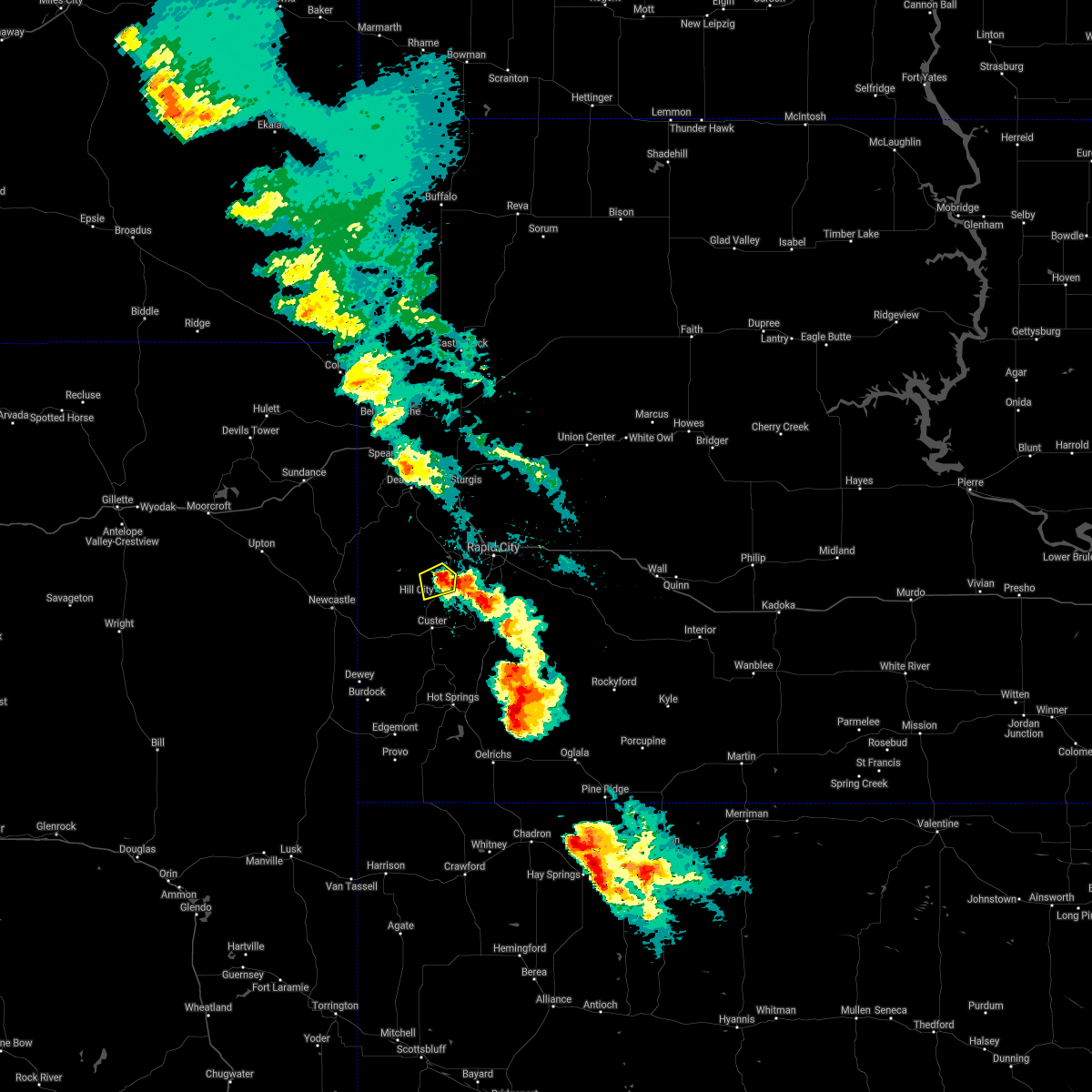 The severe thunderstorm warning for west central pennington county will expire at 345 am mdt, the storm which prompted the warning has weakened below severe limits, and no longer poses an immediate threat to life or property. therefore, the warning will be allowed to expire. however small hail and heavy rain are still possible with this thunderstorm. The severe thunderstorm warning for west central pennington county will expire at 345 am mdt, the storm which prompted the warning has weakened below severe limits, and no longer poses an immediate threat to life or property. therefore, the warning will be allowed to expire. however small hail and heavy rain are still possible with this thunderstorm.
|
| 6/15/2021 3:18 AM MDT |
 At 318 am mdt, a severe thunderstorm was located near hill city, moving east at 15 mph (radar indicated). Hazards include quarter size hail. Damage to vehicles is expected. Locations impacted include, hill city and sheridan lake. At 318 am mdt, a severe thunderstorm was located near hill city, moving east at 15 mph (radar indicated). Hazards include quarter size hail. Damage to vehicles is expected. Locations impacted include, hill city and sheridan lake.
|
| 6/15/2021 3:01 AM MDT |
 At 301 am mdt, a severe thunderstorm was located 4 miles north of medicine mountain, or 6 miles northwest of hill city, moving northeast at 10 mph (radar indicated). Hazards include golf ball size hail. People and animals outdoors will be injured. expect damage to roofs, siding, windows, and vehicles. Locations impacted include, hill city, medicine mountain and sheridan lake. At 301 am mdt, a severe thunderstorm was located 4 miles north of medicine mountain, or 6 miles northwest of hill city, moving northeast at 10 mph (radar indicated). Hazards include golf ball size hail. People and animals outdoors will be injured. expect damage to roofs, siding, windows, and vehicles. Locations impacted include, hill city, medicine mountain and sheridan lake.
|
| 6/15/2021 2:49 AM MDT | Hen Egg sized hail reported 11.3 miles ESE of Hill City, SD |
| 6/8/2021 8:22 PM MDT |
 At 821 pm mdt, severe thunderstorms were located along a line extending from 3 miles north of silver city to custer state park to 2 miles southwest of argyle, moving east at 30 mph (radar indicated). Hazards include 60 mph wind gusts and quarter size hail. Hail damage to vehicles is expected. expect wind damage to roofs, siding, and trees. locations impacted include, silver city, stockade lake, pactola reservoir, mount coolidge, custer state park, black elk peak, blue bell, palmer gulch resort, legion lake, mount rushmore national memorial, horse thief lake, johnson siding, keystone, hisega, black hills playhouse, center lake, state game lodge, wind cave national park, hayward, black hawk and buffalo gap. This includes interstate 90 in south dakota between mile markers 54 and 57. At 821 pm mdt, severe thunderstorms were located along a line extending from 3 miles north of silver city to custer state park to 2 miles southwest of argyle, moving east at 30 mph (radar indicated). Hazards include 60 mph wind gusts and quarter size hail. Hail damage to vehicles is expected. expect wind damage to roofs, siding, and trees. locations impacted include, silver city, stockade lake, pactola reservoir, mount coolidge, custer state park, black elk peak, blue bell, palmer gulch resort, legion lake, mount rushmore national memorial, horse thief lake, johnson siding, keystone, hisega, black hills playhouse, center lake, state game lodge, wind cave national park, hayward, black hawk and buffalo gap. This includes interstate 90 in south dakota between mile markers 54 and 57.
|
| 6/8/2021 8:03 PM MDT |
 At 802 pm mdt, severe thunderstorms were located along a line extending from near rochford to 5 miles northeast of jewel cave national monument to 5 miles southeast of burdock, moving east at 30 mph (radar indicated). Hazards include 60 mph wind gusts and quarter size hail. Hail damage to vehicles is expected. expect wind damage to roofs, siding, and trees. these severe storms will be near, rochford and bear mountain lookout around 805 pm mdt. other locations in the path of these severe thunderstorms include mystic, custer, crazy horse memorial, silver city, custer state park, sylvan lake, pactola reservoir, black elk peak, stockade lake, mount coolidge, blue bell, johnson siding, argyle, center lake, black hills playhouse, legion lake, mount rushmore national memorial, horse thief lake, keystone, cottonwood springs dam, state game lodge, hayward, cold brook reservoir and wind cave national park. This includes interstate 90 in south dakota between mile markers 54 and 57. At 802 pm mdt, severe thunderstorms were located along a line extending from near rochford to 5 miles northeast of jewel cave national monument to 5 miles southeast of burdock, moving east at 30 mph (radar indicated). Hazards include 60 mph wind gusts and quarter size hail. Hail damage to vehicles is expected. expect wind damage to roofs, siding, and trees. these severe storms will be near, rochford and bear mountain lookout around 805 pm mdt. other locations in the path of these severe thunderstorms include mystic, custer, crazy horse memorial, silver city, custer state park, sylvan lake, pactola reservoir, black elk peak, stockade lake, mount coolidge, blue bell, johnson siding, argyle, center lake, black hills playhouse, legion lake, mount rushmore national memorial, horse thief lake, keystone, cottonwood springs dam, state game lodge, hayward, cold brook reservoir and wind cave national park. This includes interstate 90 in south dakota between mile markers 54 and 57.
|
| 6/8/2021 7:46 PM MDT |
 At 745 pm mdt, severe thunderstorms were located along a line extending from near crooks tower to 8 miles south of moon to near dewey, moving east at 30 mph (radar indicated). Hazards include 60 mph wind gusts and penny size hail. Expect damage to roofs, siding, and trees. severe thunderstorms will be near, flag mountain and deerfield around 750 pm mdt. jewel cave national monument around 755 pm mdt. rochford and bear mountain lookout around 805 pm mdt. other locations in the path of these severe thunderstorms include mystic, medicine mountain, crazy horse memorial, custer, silver city, custer state park, pactola reservoir, hill city, argyle, black elk peak, sylvan lake, palmer gulch resort, stockade lake, johnson siding, pringle, horse thief lake, sheridan lake, cottonwood springs dam and legion lake. This includes interstate 90 in south dakota between mile markers 54 and 57. At 745 pm mdt, severe thunderstorms were located along a line extending from near crooks tower to 8 miles south of moon to near dewey, moving east at 30 mph (radar indicated). Hazards include 60 mph wind gusts and penny size hail. Expect damage to roofs, siding, and trees. severe thunderstorms will be near, flag mountain and deerfield around 750 pm mdt. jewel cave national monument around 755 pm mdt. rochford and bear mountain lookout around 805 pm mdt. other locations in the path of these severe thunderstorms include mystic, medicine mountain, crazy horse memorial, custer, silver city, custer state park, pactola reservoir, hill city, argyle, black elk peak, sylvan lake, palmer gulch resort, stockade lake, johnson siding, pringle, horse thief lake, sheridan lake, cottonwood springs dam and legion lake. This includes interstate 90 in south dakota between mile markers 54 and 57.
|
| 8/27/2020 5:21 AM MDT |
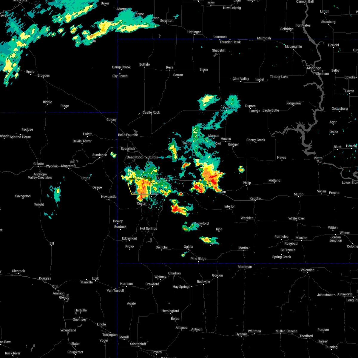 The severe thunderstorm warning for west central pennington county will expire at 530 am mdt, the storm which prompted the warning is weakening below severe limits, and will no longer poses an immediate threat to life or property. therefore, the warning will be allowed to expire. however small hail is still possible with this thunderstorm. The severe thunderstorm warning for west central pennington county will expire at 530 am mdt, the storm which prompted the warning is weakening below severe limits, and will no longer poses an immediate threat to life or property. therefore, the warning will be allowed to expire. however small hail is still possible with this thunderstorm.
|
| 8/27/2020 5:08 AM MDT |
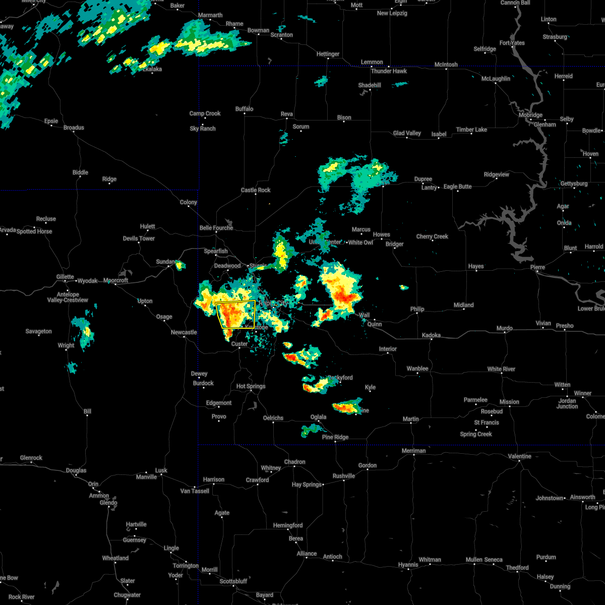 At 508 am mdt, a severe thunderstorm was located near mystic, or 8 miles north of hill city, moving east at 30 mph (radar indicated). Hazards include half dollar size hail. Damage to vehicles is expected. this severe storm will be near, pactola reservoir around 515 am mdt. sheridan lake around 520 am mdt. Johnson siding around 525 am mdt. At 508 am mdt, a severe thunderstorm was located near mystic, or 8 miles north of hill city, moving east at 30 mph (radar indicated). Hazards include half dollar size hail. Damage to vehicles is expected. this severe storm will be near, pactola reservoir around 515 am mdt. sheridan lake around 520 am mdt. Johnson siding around 525 am mdt.
|
| 8/27/2020 5:00 AM MDT | Half Dollar sized hail reported 11.3 miles ESE of Hill City, SD |
| 8/27/2020 5:00 AM MDT | Ping Pong Ball sized hail reported 11.3 miles ESE of Hill City, SD |
| 8/27/2020 4:42 AM MDT |
 At 442 am mdt, a severe thunderstorm was located over flag mountain, or 16 miles northwest of hill city, moving east at 30 mph (radar indicated). Hazards include ping pong ball size hail. People and animals outdoors will be injured. expect damage to roofs, siding, windows, and vehicles. this severe thunderstorm will be near, flag mountain and deerfield reservoir around 445 am mdt. rochford around 455 am mdt. mystic around 505 am mdt. silver city and pactola reservoir around 515 am mdt. Johnson siding and sheridan lake around 525 am mdt. At 442 am mdt, a severe thunderstorm was located over flag mountain, or 16 miles northwest of hill city, moving east at 30 mph (radar indicated). Hazards include ping pong ball size hail. People and animals outdoors will be injured. expect damage to roofs, siding, windows, and vehicles. this severe thunderstorm will be near, flag mountain and deerfield reservoir around 445 am mdt. rochford around 455 am mdt. mystic around 505 am mdt. silver city and pactola reservoir around 515 am mdt. Johnson siding and sheridan lake around 525 am mdt.
|
| 8/7/2020 4:58 PM MDT | Quarter sized hail reported 15 miles SSE of Hill City, SD |
| 7/10/2020 5:25 PM MDT |
 At 525 pm mdt, a severe thunderstorm was located 3 miles southeast of medicine mountain, or 6 miles southwest of hill city, moving east at 20 mph (radar indicated). Hazards include golf ball size hail. People and animals outdoors will be injured. expect damage to roofs, siding, windows, and vehicles. this severe thunderstorm will be near, crazy horse memorial around 535 pm mdt. custer, sylvan lake, custer state park and palmer gulch resort around 540 pm mdt. black elk peak around 545 pm mdt. mount rushmore national memorial and horse thief lake around 550 pm mdt. keystone and stockade lake around 555 pm mdt. black hills playhouse, center lake, legion lake, mount coolidge and blue bell around 600 pm mdt. Hayward and state game lodge around 610 pm mdt. At 525 pm mdt, a severe thunderstorm was located 3 miles southeast of medicine mountain, or 6 miles southwest of hill city, moving east at 20 mph (radar indicated). Hazards include golf ball size hail. People and animals outdoors will be injured. expect damage to roofs, siding, windows, and vehicles. this severe thunderstorm will be near, crazy horse memorial around 535 pm mdt. custer, sylvan lake, custer state park and palmer gulch resort around 540 pm mdt. black elk peak around 545 pm mdt. mount rushmore national memorial and horse thief lake around 550 pm mdt. keystone and stockade lake around 555 pm mdt. black hills playhouse, center lake, legion lake, mount coolidge and blue bell around 600 pm mdt. Hayward and state game lodge around 610 pm mdt.
|
| 7/5/2020 7:50 PM MDT |
 At 749 pm mdt, severe thunderstorms were located along a line extending from 4 miles west of flag mountain to 2 miles northwest of medicine mountain to custer, moving northeast at 35 mph (radar indicated). Hazards include 70 mph wind gusts and half dollar size hail. Hail damage to vehicles is expected. expect considerable tree damage. wind damage is also likely to mobile homes, roofs, and outbuildings. Locations impacted include, custer, hill city, keystone, silver city, rochford, flag mountain, mystic, deerfield, deerfield reservoir, mount rushmore national memorial, crazy horse memorial, redbank spring campground, sheridan lake, bear mountain lookout, black fox campground, horse thief lake, jewel cave national monument, palmer gulch resort, and roubaix lake. At 749 pm mdt, severe thunderstorms were located along a line extending from 4 miles west of flag mountain to 2 miles northwest of medicine mountain to custer, moving northeast at 35 mph (radar indicated). Hazards include 70 mph wind gusts and half dollar size hail. Hail damage to vehicles is expected. expect considerable tree damage. wind damage is also likely to mobile homes, roofs, and outbuildings. Locations impacted include, custer, hill city, keystone, silver city, rochford, flag mountain, mystic, deerfield, deerfield reservoir, mount rushmore national memorial, crazy horse memorial, redbank spring campground, sheridan lake, bear mountain lookout, black fox campground, horse thief lake, jewel cave national monument, palmer gulch resort, and roubaix lake.
|
| 7/5/2020 7:36 PM MDT |
 At 735 pm mdt, severe thunderstorms were located along a line extending from near four corners to 6 miles west of bear mountain lookout to 5 miles east of jewel cave national monument, moving northeast at 45 mph (radar indicated). Hazards include 70 mph wind gusts and quarter size hail. Hail damage to vehicles is expected. expect considerable tree damage. wind damage is also likely to mobile homes, roofs, and outbuildings. Locations impacted include, custer, hill city, keystone, silver city, rochford, flag mountain, mystic, moon, deerfield, mount rushmore national memorial, crazy horse memorial, sheridan lake, bear mountain lookout, mallo camp, black fox campground, and jewel cave national monument. At 735 pm mdt, severe thunderstorms were located along a line extending from near four corners to 6 miles west of bear mountain lookout to 5 miles east of jewel cave national monument, moving northeast at 45 mph (radar indicated). Hazards include 70 mph wind gusts and quarter size hail. Hail damage to vehicles is expected. expect considerable tree damage. wind damage is also likely to mobile homes, roofs, and outbuildings. Locations impacted include, custer, hill city, keystone, silver city, rochford, flag mountain, mystic, moon, deerfield, mount rushmore national memorial, crazy horse memorial, sheridan lake, bear mountain lookout, mallo camp, black fox campground, and jewel cave national monument.
|
| 7/5/2020 7:20 PM MDT |
 At 719 pm mdt, severe thunderstorms were located along a line extending from 5 miles northeast of osage to 5 miles north of elk mountain lookout to 7 miles northeast of dewey, moving northeast at 45 mph (radar indicated). Hazards include 70 mph wind gusts and quarter size hail. Hail damage to vehicles is expected. expect considerable tree damage. Wind damage is also likely to mobile homes, roofs, and outbuildings. At 719 pm mdt, severe thunderstorms were located along a line extending from 5 miles northeast of osage to 5 miles north of elk mountain lookout to 7 miles northeast of dewey, moving northeast at 45 mph (radar indicated). Hazards include 70 mph wind gusts and quarter size hail. Hail damage to vehicles is expected. expect considerable tree damage. Wind damage is also likely to mobile homes, roofs, and outbuildings.
|
| 7/2/2020 3:52 PM MDT |
 The severe thunderstorm warning for south central pennington county will expire at 400 pm mdt, the storms which prompted the warning have weakened below severe limits, and no longer poses an immediate threat to life or property. therefore, the warning will be allowed to expire. however small hail and gusty winds are still possible with thunderstorms in the area. a severe thunderstorm watch remains in effect until 800 pm mdt for southwestern and west central south dakota. The severe thunderstorm warning for south central pennington county will expire at 400 pm mdt, the storms which prompted the warning have weakened below severe limits, and no longer poses an immediate threat to life or property. therefore, the warning will be allowed to expire. however small hail and gusty winds are still possible with thunderstorms in the area. a severe thunderstorm watch remains in effect until 800 pm mdt for southwestern and west central south dakota.
|
| 7/2/2020 3:34 PM MDT |
 At 332 pm mdt, a severe thunderstorm was located 3 miles west of rapid city, moving east at 25 mph (radar indicated). Hazards include golf ball size hail. People and animals outdoors will be injured. expect damage to roofs, siding, windows, and vehicles. this severe storm will be near, rapid city around 340 pm mdt. rapid valley around 350 pm mdt. another severe thunderstorm was just east of hill city and will affect mt rushmore around 345 pm mdt. This includes interstate 90 in south dakota between mile markers 54 and 63. At 332 pm mdt, a severe thunderstorm was located 3 miles west of rapid city, moving east at 25 mph (radar indicated). Hazards include golf ball size hail. People and animals outdoors will be injured. expect damage to roofs, siding, windows, and vehicles. this severe storm will be near, rapid city around 340 pm mdt. rapid valley around 350 pm mdt. another severe thunderstorm was just east of hill city and will affect mt rushmore around 345 pm mdt. This includes interstate 90 in south dakota between mile markers 54 and 63.
|
| 7/2/2020 3:11 PM MDT |
 At 311 pm mdt, severe thunderstorms were located along a line extending from 3 miles southeast of pactola reservoir to near palmer gulch resort, moving east at 25 mph (radar indicated). Hazards include golf ball size hail. People and animals outdoors will be injured. expect damage to roofs, siding, windows, and vehicles. locations impacted include, rapid city, hill city, rapid valley, black hawk, keystone, hisega, hayward, rockerville, mount rushmore national memorial, bear country, hart ranch, sylvan lake, sheridan lake, reptile gardens, black elk peak, horse thief lake and palmer gulch resort. This includes interstate 90 in south dakota between mile markers 54 and 63. At 311 pm mdt, severe thunderstorms were located along a line extending from 3 miles southeast of pactola reservoir to near palmer gulch resort, moving east at 25 mph (radar indicated). Hazards include golf ball size hail. People and animals outdoors will be injured. expect damage to roofs, siding, windows, and vehicles. locations impacted include, rapid city, hill city, rapid valley, black hawk, keystone, hisega, hayward, rockerville, mount rushmore national memorial, bear country, hart ranch, sylvan lake, sheridan lake, reptile gardens, black elk peak, horse thief lake and palmer gulch resort. This includes interstate 90 in south dakota between mile markers 54 and 63.
|
| 7/2/2020 2:57 PM MDT |
 At 256 pm mdt, a severe thunderstorm was located 3 miles west of sheridan lake, or 3 miles northeast of hill city, moving east at 25 mph (radar indicated). Hazards include 60 mph wind gusts and half dollar size hail. Hail damage to vehicles is expected. Expect wind damage to roofs, siding, and trees. At 256 pm mdt, a severe thunderstorm was located 3 miles west of sheridan lake, or 3 miles northeast of hill city, moving east at 25 mph (radar indicated). Hazards include 60 mph wind gusts and half dollar size hail. Hail damage to vehicles is expected. Expect wind damage to roofs, siding, and trees.
|
| 7/2/2020 2:35 PM MDT |
 At 235 pm mdt, a severe thunderstorm was located 3 miles northeast of medicine mountain, or 5 miles west of hill city, moving northeast at 25 mph (radar indicated). Hazards include half dollar size hail. Damage to vehicles is expected. Locations impacted include, silver city, mystic, pactola reservoir, sheridan lake and medicine mountain. At 235 pm mdt, a severe thunderstorm was located 3 miles northeast of medicine mountain, or 5 miles west of hill city, moving northeast at 25 mph (radar indicated). Hazards include half dollar size hail. Damage to vehicles is expected. Locations impacted include, silver city, mystic, pactola reservoir, sheridan lake and medicine mountain.
|
| 7/2/2020 2:25 PM MDT |
 At 224 pm mdt, a severe thunderstorm was located over medicine mountain, or 7 miles west of hill city, moving northeast at 25 mph (radar indicated). Hazards include hail up to half dollar size. Damage to vehicles is expected. this severe storm will be near, hill city and palmer gulch resort around 240 pm mdt. mystic around 245 pm mdt. sheridan lake around 250 pm mdt. Silver city and pactola reservoir around 255 pm mdt. At 224 pm mdt, a severe thunderstorm was located over medicine mountain, or 7 miles west of hill city, moving northeast at 25 mph (radar indicated). Hazards include hail up to half dollar size. Damage to vehicles is expected. this severe storm will be near, hill city and palmer gulch resort around 240 pm mdt. mystic around 245 pm mdt. sheridan lake around 250 pm mdt. Silver city and pactola reservoir around 255 pm mdt.
|
| 7/2/2020 2:20 PM MDT | Half Dollar sized hail reported 10.4 miles ESE of Hill City, SD, delayed report. time estimated from radar. |
| 7/2/2020 2:06 PM MDT |
 At 205 pm mdt, a severe thunderstorm was located 4 miles west of bear mountain lookout, or 13 miles northwest of custer, moving northeast at 25 mph (radar indicated). Hazards include golf ball size hail. People and animals outdoors will be injured. expect damage to roofs, siding, windows, and vehicles. this severe thunderstorm will be near, bear mountain lookout around 215 pm mdt. sylvan lake around 230 pm mdt. black elk peak around 235 pm mdt. hill city and palmer gulch resort around 240 pm mdt. horse thief lake and mount rushmore national memorial around 245 pm mdt. silver city, and pactola reservoir around 250 pm mdt. Rockerville around 300 pm mdt. At 205 pm mdt, a severe thunderstorm was located 4 miles west of bear mountain lookout, or 13 miles northwest of custer, moving northeast at 25 mph (radar indicated). Hazards include golf ball size hail. People and animals outdoors will be injured. expect damage to roofs, siding, windows, and vehicles. this severe thunderstorm will be near, bear mountain lookout around 215 pm mdt. sylvan lake around 230 pm mdt. black elk peak around 235 pm mdt. hill city and palmer gulch resort around 240 pm mdt. horse thief lake and mount rushmore national memorial around 245 pm mdt. silver city, and pactola reservoir around 250 pm mdt. Rockerville around 300 pm mdt.
|
| 6/29/2020 6:20 PM MDT | Quarter sized hail reported 14.3 miles ESE of Hill City, SD |
| 6/28/2020 7:56 PM MDT |
 The severe thunderstorm warning for west central pennington county will expire at 800 pm mdt, the storm which prompted the warning has weakened below severe limits, and no longer poses an immediate threat to life or property. therefore, the warning will be allowed to expire. however small hail and gusty winds are still possible with this thunderstorm. a severe thunderstorm watch remains in effect until 900 pm mdt for west central south dakota. The severe thunderstorm warning for west central pennington county will expire at 800 pm mdt, the storm which prompted the warning has weakened below severe limits, and no longer poses an immediate threat to life or property. therefore, the warning will be allowed to expire. however small hail and gusty winds are still possible with this thunderstorm. a severe thunderstorm watch remains in effect until 900 pm mdt for west central south dakota.
|
| 6/28/2020 7:41 PM MDT |
 At 740 pm mdt, a severe thunderstorm was located 4 miles northwest of hill city, moving northeast at 30 mph (radar indicated). Hazards include golf ball size hail. People and animals outdoors will be injured. expect damage to roofs, siding, windows, and vehicles. this severe storm will be near, sheridan lake around 750 pm mdt. silver city and pactola reservoir around 755 pm mdt. Johnson siding and hisega around 805 pm mdt. At 740 pm mdt, a severe thunderstorm was located 4 miles northwest of hill city, moving northeast at 30 mph (radar indicated). Hazards include golf ball size hail. People and animals outdoors will be injured. expect damage to roofs, siding, windows, and vehicles. this severe storm will be near, sheridan lake around 750 pm mdt. silver city and pactola reservoir around 755 pm mdt. Johnson siding and hisega around 805 pm mdt.
|
| 6/28/2020 7:40 PM MDT | Ping Pong Ball sized hail reported 4 miles SE of Hill City, SD |
| 6/28/2020 7:18 PM MDT |
 At 717 pm mdt, a severe thunderstorm was located over bear mountain lookout, or 10 miles southwest of hill city, moving northeast at 30 mph (radar indicated). Hazards include 60 mph wind gusts and quarter size hail. Hail damage to vehicles is expected. expect wind damage to roofs, siding, and trees. this severe thunderstorm will be near, hill city and black elk peak around 735 pm mdt. mount rushmore national memorial around 745 pm mdt. rockerville around 755 pm mdt. Johnson siding and hisega around 800 pm mdt. At 717 pm mdt, a severe thunderstorm was located over bear mountain lookout, or 10 miles southwest of hill city, moving northeast at 30 mph (radar indicated). Hazards include 60 mph wind gusts and quarter size hail. Hail damage to vehicles is expected. expect wind damage to roofs, siding, and trees. this severe thunderstorm will be near, hill city and black elk peak around 735 pm mdt. mount rushmore national memorial around 745 pm mdt. rockerville around 755 pm mdt. Johnson siding and hisega around 800 pm mdt.
|
| 6/28/2020 5:35 PM MDT | Quarter sized hail reported 13 miles SSE of Hill City, SD |
| 6/6/2020 6:35 PM MDT |
 At 635 pm mdt, severe thunderstorms were located along a line extending from 4 miles east of fort meade to 2 miles northwest of rapid valley to 7 miles southwest of red shirt, moving northeast at 55 mph (radar indicated). Hazards include 70 mph wind gusts. Expect considerable tree damage. damage is likely to mobile homes, roofs, and outbuildings. these severe storms will be near, ellsworth air force base, box elder and rapid city airport around 640 pm mdt. new underwood around 650 pm mdt. scenic around 705 pm mdt. southwestern badlands national park around 720 pm mdt. This includes interstate 90 in south dakota between mile markers 35 and 92. At 635 pm mdt, severe thunderstorms were located along a line extending from 4 miles east of fort meade to 2 miles northwest of rapid valley to 7 miles southwest of red shirt, moving northeast at 55 mph (radar indicated). Hazards include 70 mph wind gusts. Expect considerable tree damage. damage is likely to mobile homes, roofs, and outbuildings. these severe storms will be near, ellsworth air force base, box elder and rapid city airport around 640 pm mdt. new underwood around 650 pm mdt. scenic around 705 pm mdt. southwestern badlands national park around 720 pm mdt. This includes interstate 90 in south dakota between mile markers 35 and 92.
|
| 6/6/2020 6:24 PM MDT | Storm damage reported in pennington county SD, 0.3 miles NNE of Hill City, SD |
| 6/6/2020 6:08 PM MDT | Storm damage reported in pennington county SD, 19.2 miles SE of Hill City, SD |
| 6/6/2020 6:05 PM MDT |
 At 604 pm mdt, severe thunderstorms were located along a line extending from 3 miles south of cheyenne crossing to 2 miles west of hill city to 3 miles south of maverick junction, moving northeast at 65 mph. these are very dangerous storms (radar indicated). Hazards include 80 mph wind gusts. Flying debris will be dangerous to those caught without shelter. mobile homes will be heavily damaged. expect considerable damage to roofs, windows, and vehicles. extensive tree damage and power outages are likely. these severe storms will be near, keystone and sheridan lake around 610 pm mdt. johnson siding, hisega and rockerville around 615 pm mdt. rapid city around 620 pm mdt. rapid valley, black hawk and tilford around 625 pm mdt. ellsworth air force base, box elder, and rapid city airport around 630 pm mdt. red shirt around 635 pm mdt. sheep mountain table around 650 pm mdt. This includes interstate 90 in south dakota between mile markers 34 and 92. At 604 pm mdt, severe thunderstorms were located along a line extending from 3 miles south of cheyenne crossing to 2 miles west of hill city to 3 miles south of maverick junction, moving northeast at 65 mph. these are very dangerous storms (radar indicated). Hazards include 80 mph wind gusts. Flying debris will be dangerous to those caught without shelter. mobile homes will be heavily damaged. expect considerable damage to roofs, windows, and vehicles. extensive tree damage and power outages are likely. these severe storms will be near, keystone and sheridan lake around 610 pm mdt. johnson siding, hisega and rockerville around 615 pm mdt. rapid city around 620 pm mdt. rapid valley, black hawk and tilford around 625 pm mdt. ellsworth air force base, box elder, and rapid city airport around 630 pm mdt. red shirt around 635 pm mdt. sheep mountain table around 650 pm mdt. This includes interstate 90 in south dakota between mile markers 34 and 92.
|
| 6/6/2020 5:56 PM MDT |
 At 552 pm mdt, severe thunderstorms were located along a line extending from redbank spring campground to 5 miles southeast of jewel cave national monument to 7 miles east of rumford, moving northeast at 70 mph (radar indicated). Hazards include 70 mph wind gusts. Expect considerable tree damage. damage is likely to mobile homes, roofs, and outbuildings. severe thunderstorms will be near, custer, deerfield, crazy horse memorial around 600 pm mdt. oelrichs, rochford, and custer state park around 605 pm mdt. keystone, silver city and smithwick around 610 pm mdt. nemo and rockerville around 615 pm mdt. rapid city, summerset, piedmont and tilford around 620 pm mdt. rapid valley and black gap around 625 pm mdt. box elder and rapid city airport around 630 pm mdt. new underwood around 640 pm mdt. This includes interstate 90 in south dakota between mile markers 34 and 92. At 552 pm mdt, severe thunderstorms were located along a line extending from redbank spring campground to 5 miles southeast of jewel cave national monument to 7 miles east of rumford, moving northeast at 70 mph (radar indicated). Hazards include 70 mph wind gusts. Expect considerable tree damage. damage is likely to mobile homes, roofs, and outbuildings. severe thunderstorms will be near, custer, deerfield, crazy horse memorial around 600 pm mdt. oelrichs, rochford, and custer state park around 605 pm mdt. keystone, silver city and smithwick around 610 pm mdt. nemo and rockerville around 615 pm mdt. rapid city, summerset, piedmont and tilford around 620 pm mdt. rapid valley and black gap around 625 pm mdt. box elder and rapid city airport around 630 pm mdt. new underwood around 640 pm mdt. This includes interstate 90 in south dakota between mile markers 34 and 92.
|
| 5/23/2020 3:49 PM MDT |
 At 349 pm mdt, severe thunderstorms were located along a line extending from near silver city to 4 miles northwest of sheridan lake to 2 miles north of crazy horse memorial, moving east at 10 mph (radar indicated). Hazards include quarter size hail. Damage to vehicles is expected. hail may accumulate on roadways causing hazardous travel. these severe storms will be near, silver city and pactola reservoir around 355 pm mdt. sheridan lake around 405 pm mdt. palmer gulch resort around 425 pm mdt. Keystone, horse thief lake, mount rushmore national memorial and keystone wye around 430 pm mdt. At 349 pm mdt, severe thunderstorms were located along a line extending from near silver city to 4 miles northwest of sheridan lake to 2 miles north of crazy horse memorial, moving east at 10 mph (radar indicated). Hazards include quarter size hail. Damage to vehicles is expected. hail may accumulate on roadways causing hazardous travel. these severe storms will be near, silver city and pactola reservoir around 355 pm mdt. sheridan lake around 405 pm mdt. palmer gulch resort around 425 pm mdt. Keystone, horse thief lake, mount rushmore national memorial and keystone wye around 430 pm mdt.
|
| 5/23/2020 3:29 PM MDT |
 At 328 pm mdt, severe thunderstorms were located along a line extending from 2 miles northeast of mystic to 4 miles northwest of hill city to 2 miles southeast of bear mountain lookout, moving east at 10 mph (radar indicated). Hazards include quarter size hail. Damage to vehicles is expected. hail may accumulate on roadways causing hazardous travel. severe thunderstorms will be near, mystic around 335 pm mdt. silver city and pactola reservoir around 345 pm mdt. sheridan lake around 405 pm mdt. keystone wye around 410 pm mdt. Hill city, keystone, black elk peak, palmer gulch resort, horse thief lake and mount rushmore national memorial around 415 pm mdt. At 328 pm mdt, severe thunderstorms were located along a line extending from 2 miles northeast of mystic to 4 miles northwest of hill city to 2 miles southeast of bear mountain lookout, moving east at 10 mph (radar indicated). Hazards include quarter size hail. Damage to vehicles is expected. hail may accumulate on roadways causing hazardous travel. severe thunderstorms will be near, mystic around 335 pm mdt. silver city and pactola reservoir around 345 pm mdt. sheridan lake around 405 pm mdt. keystone wye around 410 pm mdt. Hill city, keystone, black elk peak, palmer gulch resort, horse thief lake and mount rushmore national memorial around 415 pm mdt.
|
| 5/3/2020 6:32 PM MDT | Quarter sized hail reported 4.4 miles N of Hill City, SD |
| 5/3/2020 6:22 PM MDT |
 At 622 pm mdt, a severe thunderstorm was located over crazy horse memorial, or 5 miles northwest of custer, moving east at 35 mph (radar indicated). Hazards include 60 mph wind gusts and quarter size hail. Hail damage to vehicles is expected. expect wind damage to roofs, siding, and trees. this severe storm will be near, hill city and northwestern custer state park around 625 pm mdt. custer, sylvan lake, black elk peak and palmer gulch resort around 630 pm mdt. stockade lake, mount rushmore national memorial and horse thief lake around 635 pm mdt. Keystone, legion lake, center lake, black hills playhouse and mount coolidge around 640 pm mdt. At 622 pm mdt, a severe thunderstorm was located over crazy horse memorial, or 5 miles northwest of custer, moving east at 35 mph (radar indicated). Hazards include 60 mph wind gusts and quarter size hail. Hail damage to vehicles is expected. expect wind damage to roofs, siding, and trees. this severe storm will be near, hill city and northwestern custer state park around 625 pm mdt. custer, sylvan lake, black elk peak and palmer gulch resort around 630 pm mdt. stockade lake, mount rushmore national memorial and horse thief lake around 635 pm mdt. Keystone, legion lake, center lake, black hills playhouse and mount coolidge around 640 pm mdt.
|
| 5/3/2020 6:07 PM MDT |
 At 606 pm mdt, a severe thunderstorm was located 3 miles west of bear mountain lookout, or 11 miles west of hill city, moving southeast at 25 mph (radar indicated). Hazards include quarter size hail. Damage to vehicles is expected. this severe thunderstorm will be near, bear mountain lookout and medicine mountain around 615 pm mdt. hill city and crazy horse memorial around 630 pm mdt. northwestern custer state park, sylvan lake, black elk peak and palmer gulch resort around 635 pm mdt. custer and horse thief lake around 640 pm mdt. Stockade lake, legion lake, mount coolidge, center lake, black hills playhouse and mount rushmore national memorial around 645 pm mdt. At 606 pm mdt, a severe thunderstorm was located 3 miles west of bear mountain lookout, or 11 miles west of hill city, moving southeast at 25 mph (radar indicated). Hazards include quarter size hail. Damage to vehicles is expected. this severe thunderstorm will be near, bear mountain lookout and medicine mountain around 615 pm mdt. hill city and crazy horse memorial around 630 pm mdt. northwestern custer state park, sylvan lake, black elk peak and palmer gulch resort around 635 pm mdt. custer and horse thief lake around 640 pm mdt. Stockade lake, legion lake, mount coolidge, center lake, black hills playhouse and mount rushmore national memorial around 645 pm mdt.
|
| 9/20/2019 8:16 PM MDT |
 At 816 pm mdt, a severe thunderstorm was located over rockerville, or 9 miles southwest of rapid city, moving northeast at 35 mph (radar indicated). Hazards include ping pong ball size hail and 60 mph wind gusts. People and animals outdoors will be injured. expect hail damage to roofs, siding, windows, and vehicles. expect wind damage to roofs, siding, and trees. locations impacted include, rapid city, hill city, rapid valley, black hawk, summerset, johnson siding, keystone, hisega, caputa, hayward, rockerville, pactola reservoir, mount rushmore national memorial, rapid city airport, bear country, keystone wye, hart ranch, sheridan lake, black gap and reptile gardens. This includes interstate 90 in south dakota between mile markers 50 and 62. At 816 pm mdt, a severe thunderstorm was located over rockerville, or 9 miles southwest of rapid city, moving northeast at 35 mph (radar indicated). Hazards include ping pong ball size hail and 60 mph wind gusts. People and animals outdoors will be injured. expect hail damage to roofs, siding, windows, and vehicles. expect wind damage to roofs, siding, and trees. locations impacted include, rapid city, hill city, rapid valley, black hawk, summerset, johnson siding, keystone, hisega, caputa, hayward, rockerville, pactola reservoir, mount rushmore national memorial, rapid city airport, bear country, keystone wye, hart ranch, sheridan lake, black gap and reptile gardens. This includes interstate 90 in south dakota between mile markers 50 and 62.
|
| 9/20/2019 8:08 PM MDT |
 At 807 pm mdt, a severe thunderstorm was located over black elk peak, or 4 miles southeast of hill city, moving northeast at 30 mph (radar indicated). Hazards include 60 mph wind gusts and half dollar size hail. Hail damage to vehicles is expected. expect wind damage to roofs, siding, and trees. locations impacted include, rapid city, hill city, rapid valley, summerset, black hawk, johnson siding, hermosa, keystone, hisega, caputa, hayward, rockerville, pactola reservoir, mount rushmore national memorial, rapid city airport, stockade lake, legion lake, state game lodge, thompson butte and sheridan lake. This includes interstate 90 in south dakota between mile markers 49 and 62. At 807 pm mdt, a severe thunderstorm was located over black elk peak, or 4 miles southeast of hill city, moving northeast at 30 mph (radar indicated). Hazards include 60 mph wind gusts and half dollar size hail. Hail damage to vehicles is expected. expect wind damage to roofs, siding, and trees. locations impacted include, rapid city, hill city, rapid valley, summerset, black hawk, johnson siding, hermosa, keystone, hisega, caputa, hayward, rockerville, pactola reservoir, mount rushmore national memorial, rapid city airport, stockade lake, legion lake, state game lodge, thompson butte and sheridan lake. This includes interstate 90 in south dakota between mile markers 49 and 62.
|
| 9/20/2019 7:58 PM MDT |
 At 758 pm mdt, a severe thunderstorm was located near custer, moving northeast at 30 mph (radar indicated). Hazards include 60 mph wind gusts and quarter size hail. Hail damage to vehicles is expected. Expect wind damage to roofs, siding, and trees. At 758 pm mdt, a severe thunderstorm was located near custer, moving northeast at 30 mph (radar indicated). Hazards include 60 mph wind gusts and quarter size hail. Hail damage to vehicles is expected. Expect wind damage to roofs, siding, and trees.
|
| 8/17/2019 1:11 PM MDT |
 The national weather service in rapid city has issued a * severe thunderstorm warning for. west central pennington county in west central south dakota. until 215 pm mdt. At 110 pm mdt, a severe thunderstorm was located near sheridan lake, or 7 miles northeast of hill city, moving east at 15 mph. The national weather service in rapid city has issued a * severe thunderstorm warning for. west central pennington county in west central south dakota. until 215 pm mdt. At 110 pm mdt, a severe thunderstorm was located near sheridan lake, or 7 miles northeast of hill city, moving east at 15 mph.
|
| 8/14/2019 10:43 PM MDT |
 At 1043 pm mdt, a severe thunderstorm was located over cheyenne crossing, or 5 miles southwest of lead, moving southeast at 30 mph (radar indicated). Hazards include quarter size hail. damage to vehicles is expected At 1043 pm mdt, a severe thunderstorm was located over cheyenne crossing, or 5 miles southwest of lead, moving southeast at 30 mph (radar indicated). Hazards include quarter size hail. damage to vehicles is expected
|
| 8/14/2019 12:42 PM MDT | Golf Ball sized hail reported 2.7 miles NNW of Hill City, SD |
| 8/14/2019 12:40 PM MDT | Quarter sized hail reported 0.9 miles WNW of Hill City, SD |
| 8/14/2019 12:39 PM MDT |
 The national weather service in rapid city has issued a * severe thunderstorm warning for. north central custer county in southwestern south dakota. western pennington county in west central south dakota. until 145 pm mdt. At 1238 pm mdt, a severe thunderstorm was located over palmer gulch. The national weather service in rapid city has issued a * severe thunderstorm warning for. north central custer county in southwestern south dakota. western pennington county in west central south dakota. until 145 pm mdt. At 1238 pm mdt, a severe thunderstorm was located over palmer gulch.
|
| 8/14/2019 12:33 PM MDT | Quarter sized hail reported 0.3 miles NNE of Hill City, SD |
| 7/24/2019 7:15 PM MDT |
 At 715 pm mdt, a severe thunderstorm was located over hill city, moving east at 25 mph (radar indicated). Hazards include 60 mph wind gusts and quarter size hail. Hail damage to vehicles is expected. expect wind damage to roofs, siding, and trees. hail may accumulate on roadways causing hazardous travel. Locations impacted include, hill city, keystone, hayward, rockerville, mount rushmore national memorial, keystone wye, state game lodge, crazy horse memorial, sylvan lake, sheridan lake, center lake, black elk peak, black hills playhouse, palmer gulch resort, horse thief lake and northern custer state park. At 715 pm mdt, a severe thunderstorm was located over hill city, moving east at 25 mph (radar indicated). Hazards include 60 mph wind gusts and quarter size hail. Hail damage to vehicles is expected. expect wind damage to roofs, siding, and trees. hail may accumulate on roadways causing hazardous travel. Locations impacted include, hill city, keystone, hayward, rockerville, mount rushmore national memorial, keystone wye, state game lodge, crazy horse memorial, sylvan lake, sheridan lake, center lake, black elk peak, black hills playhouse, palmer gulch resort, horse thief lake and northern custer state park.
|
| 7/24/2019 7:01 PM MDT |
 At 652 pm mdt, a severe thunderstorm was located 3 miles southeast of deerfield reservoir, or 9 miles northwest of hill city, moving east at 30 mph (radar indicated). Hazards include ping pong ball size hail and 60 mph wind gusts. People and animals outdoors will be injured. expect hail damage to roofs, siding, windows, and vehicles. Expect wind damage to roofs, siding, and trees. At 652 pm mdt, a severe thunderstorm was located 3 miles southeast of deerfield reservoir, or 9 miles northwest of hill city, moving east at 30 mph (radar indicated). Hazards include ping pong ball size hail and 60 mph wind gusts. People and animals outdoors will be injured. expect hail damage to roofs, siding, windows, and vehicles. Expect wind damage to roofs, siding, and trees.
|
| 7/24/2019 7:00 PM MDT | Half Dollar sized hail reported 11.3 miles ESE of Hill City, SD |
| 7/24/2019 6:53 PM MDT |
 At 652 pm mdt, a severe thunderstorm was located 3 miles southeast of deerfield reservoir, or 9 miles northwest of hill city, moving east at 30 mph (radar indicated). Hazards include ping pong ball size hail and 60 mph wind gusts. People and animals outdoors will be injured. expect hail damage to roofs, siding, windows, and vehicles. Expect wind damage to roofs, siding, and trees. At 652 pm mdt, a severe thunderstorm was located 3 miles southeast of deerfield reservoir, or 9 miles northwest of hill city, moving east at 30 mph (radar indicated). Hazards include ping pong ball size hail and 60 mph wind gusts. People and animals outdoors will be injured. expect hail damage to roofs, siding, windows, and vehicles. Expect wind damage to roofs, siding, and trees.
|
| 7/24/2019 6:50 PM MDT | Quarter sized hail reported 12 miles ESE of Hill City, SD, 10ft trees knocked down that were about 1 foot thick... with limbs everywhere. metal storage shed blown over also. |
| 7/24/2019 6:50 PM MDT | 10ft trees knocked down that were about 1 foot thick... with limbs everywhere. metal storage shed blown over als in pennington county SD, 12 miles ESE of Hill City, SD |
| 7/24/2019 6:50 PM MDT | 10ft trees knocked down that were about 1 foot thick... with limbs everywhere. metal storage shed blown over als in pennington county SD, 12 miles ESE of Hill City, SD |
| 7/24/2019 6:43 PM MDT | Half Dollar sized hail reported 11.3 miles ESE of Hill City, SD, hail accumulated 4 inches deep |
| 7/23/2019 4:59 PM MDT | Ping Pong Ball sized hail reported 14.7 miles SE of Hill City, SD |
| 7/23/2019 4:48 PM MDT | Ping Pong Ball sized hail reported 14.7 miles SE of Hill City, SD |
| 7/23/2019 4:41 PM MDT | Ping Pong Ball sized hail reported 14.7 miles SE of Hill City, SD |
| 7/23/2019 4:00 PM MDT | Golf Ball sized hail reported 12 miles ESE of Hill City, SD |
| 7/4/2019 8:58 PM MDT |
 At 858 pm mdt, severe thunderstorms were located along a line extending from 2 miles southeast of apple springs to near ellsworth air force base to horse thief lake, moving east at 50 mph (radar indicated). Hazards include 70 mph wind gusts and quarter size hail. Hail damage to vehicles is expected. expect considerable tree damage. wind damage is also likely to mobile homes, roofs, and outbuildings. locations impacted include, rapid city, sturgis, lead, hill city, rapid valley, ellsworth air force base, box elder, summerset, black hawk, deadwood, new underwood, johnson siding, nemo, hermosa, keystone, piedmont, hisega, silver city, rochford and brownsville. This includes interstate 90 in south dakota between mile markers 32 and 80. At 858 pm mdt, severe thunderstorms were located along a line extending from 2 miles southeast of apple springs to near ellsworth air force base to horse thief lake, moving east at 50 mph (radar indicated). Hazards include 70 mph wind gusts and quarter size hail. Hail damage to vehicles is expected. expect considerable tree damage. wind damage is also likely to mobile homes, roofs, and outbuildings. locations impacted include, rapid city, sturgis, lead, hill city, rapid valley, ellsworth air force base, box elder, summerset, black hawk, deadwood, new underwood, johnson siding, nemo, hermosa, keystone, piedmont, hisega, silver city, rochford and brownsville. This includes interstate 90 in south dakota between mile markers 32 and 80.
|
| 7/4/2019 8:48 PM MDT | Rapid creek out of it's banks in rochfor in pennington county SD, 15 miles SSE of Hill City, SD |
| 7/4/2019 8:38 PM MDT |
 At 837 pm mdt, severe thunderstorms were located along a line extending from 4 miles east of cheyenne crossing to 2 miles north of mystic to 4 miles west of crazy horse memorial, moving northeast at 40 mph (radar indicated). Hazards include 70 mph wind gusts. Expect considerable tree damage. Damage is likely to mobile homes, roofs, and outbuildings. At 837 pm mdt, severe thunderstorms were located along a line extending from 4 miles east of cheyenne crossing to 2 miles north of mystic to 4 miles west of crazy horse memorial, moving northeast at 40 mph (radar indicated). Hazards include 70 mph wind gusts. Expect considerable tree damage. Damage is likely to mobile homes, roofs, and outbuildings.
|
| 9/9/2018 2:10 PM MDT |
 At 208 pm mdt, a severe thunderstorm was located over pactola reservoir, or 10 miles north of hill city, moving southeast at 15 mph (radar indicated. at 202 pm, half dollar sized hail was reported 3 miles south southeast of silver city). Hazards include ping pong ball size hail and 60 mph wind gusts. People and animals outdoors will be injured. expect hail damage to roofs, siding, windows, and vehicles. expect wind damage to roofs, siding, and trees. locations impacted include, rapid city, black hawk, johnson siding, silver city, hisega, mystic, pactola reservoir and sheridan lake. This includes interstate 90 in south dakota between mile markers 55 and 60. At 208 pm mdt, a severe thunderstorm was located over pactola reservoir, or 10 miles north of hill city, moving southeast at 15 mph (radar indicated. at 202 pm, half dollar sized hail was reported 3 miles south southeast of silver city). Hazards include ping pong ball size hail and 60 mph wind gusts. People and animals outdoors will be injured. expect hail damage to roofs, siding, windows, and vehicles. expect wind damage to roofs, siding, and trees. locations impacted include, rapid city, black hawk, johnson siding, silver city, hisega, mystic, pactola reservoir and sheridan lake. This includes interstate 90 in south dakota between mile markers 55 and 60.
|
| 9/9/2018 1:56 PM MDT |
 At 155 pm mdt, a severe thunderstorm was located over silver city, or 12 miles north of hill city, moving southeast at 20 mph (radar indicated). Hazards include ping pong ball size hail and 60 mph wind gusts. People and animals outdoors will be injured. expect hail damage to roofs, siding, windows, and vehicles. Expect wind damage to roofs, siding, and trees. At 155 pm mdt, a severe thunderstorm was located over silver city, or 12 miles north of hill city, moving southeast at 20 mph (radar indicated). Hazards include ping pong ball size hail and 60 mph wind gusts. People and animals outdoors will be injured. expect hail damage to roofs, siding, windows, and vehicles. Expect wind damage to roofs, siding, and trees.
|
| 8/3/2018 8:58 PM MDT |
 At 857 pm mdt, severe thunderstorms were located along a line extending from 5 miles northeast of newell lake to 10 miles northeast of piedmont to near hermosa, moving east at 40 mph (radar indicated). Hazards include 70 mph wind gusts. Expect considerable tree damage. damage is likely to mobile homes, roofs, and outbuildings. locations impacted include, rapid city, sturgis, lead, hill city, rapid valley, ellsworth air force base, box elder, summerset, black hawk, deadwood, whitewood, johnson siding, newell, nemo, keystone, nisland, piedmont, saint onge, vale and hisega. This includes interstate 90 in south dakota between mile markers 17 and 72. At 857 pm mdt, severe thunderstorms were located along a line extending from 5 miles northeast of newell lake to 10 miles northeast of piedmont to near hermosa, moving east at 40 mph (radar indicated). Hazards include 70 mph wind gusts. Expect considerable tree damage. damage is likely to mobile homes, roofs, and outbuildings. locations impacted include, rapid city, sturgis, lead, hill city, rapid valley, ellsworth air force base, box elder, summerset, black hawk, deadwood, whitewood, johnson siding, newell, nemo, keystone, nisland, piedmont, saint onge, vale and hisega. This includes interstate 90 in south dakota between mile markers 17 and 72.
|
| 8/3/2018 8:43 PM MDT |
 At 823 pm mdt, severe thunderstorms were located along a line extending from 12 miles north of belle fourche to 3 miles west of brownsville to 6 miles northwest of jewel cave national monument, moving east at 40 mph (radar indicated). Hazards include 70 mph wind gusts. Expect considerable tree damage. Damage is likely to mobile homes, roofs, and outbuildings. At 823 pm mdt, severe thunderstorms were located along a line extending from 12 miles north of belle fourche to 3 miles west of brownsville to 6 miles northwest of jewel cave national monument, moving east at 40 mph (radar indicated). Hazards include 70 mph wind gusts. Expect considerable tree damage. Damage is likely to mobile homes, roofs, and outbuildings.
|
| 8/3/2018 8:24 PM MDT |
 At 823 pm mdt, severe thunderstorms were located along a line extending from 12 miles north of belle fourche to 3 miles west of brownsville to 6 miles northwest of jewel cave national monument, moving east at 40 mph (radar indicated). Hazards include 70 mph wind gusts. Expect considerable tree damage. Damage is likely to mobile homes, roofs, and outbuildings. At 823 pm mdt, severe thunderstorms were located along a line extending from 12 miles north of belle fourche to 3 miles west of brownsville to 6 miles northwest of jewel cave national monument, moving east at 40 mph (radar indicated). Hazards include 70 mph wind gusts. Expect considerable tree damage. Damage is likely to mobile homes, roofs, and outbuildings.
|
| 8/3/2018 4:50 PM MDT |
 At 450 pm mdt, a severe thunderstorm was located near hill city, moving southeast at 25 mph (public). Hazards include quarter size hail. Damage to vehicles is expected. Locations impacted include, hill city, keystone, rockerville, pactola reservoir, sheridan lake, mount rushmore national memorial, keystone wye, black elk peak, sylvan lake, horse thief lake, and northwestern custer state park. At 450 pm mdt, a severe thunderstorm was located near hill city, moving southeast at 25 mph (public). Hazards include quarter size hail. Damage to vehicles is expected. Locations impacted include, hill city, keystone, rockerville, pactola reservoir, sheridan lake, mount rushmore national memorial, keystone wye, black elk peak, sylvan lake, horse thief lake, and northwestern custer state park.
|
| 8/3/2018 4:40 PM MDT | Quarter sized hail reported 6.4 miles SE of Hill City, SD |
| 8/3/2018 4:35 PM MDT |
 At 435 pm mdt, a severe thunderstorm was located 3 miles north of hill city, moving southeast at 15 mph (radar indicated). Hazards include quarter size hail. damage to vehicles is expected At 435 pm mdt, a severe thunderstorm was located 3 miles north of hill city, moving southeast at 15 mph (radar indicated). Hazards include quarter size hail. damage to vehicles is expected
|
| 7/29/2018 4:05 PM MDT |
 The severe thunderstorm warning for north central custer and southwestern pennington counties will expire at 415 pm mdt, the storm which prompted the warning has weakened below severe limits, and no longer poses an immediate threat to life or property. therefore, the warning will be allowed to expire. however small hail, gusty winds and heavy rain are still possible with this thunderstorm. a severe thunderstorm watch remains in effect until 900 pm mdt for southwestern and west central south dakota. The severe thunderstorm warning for north central custer and southwestern pennington counties will expire at 415 pm mdt, the storm which prompted the warning has weakened below severe limits, and no longer poses an immediate threat to life or property. therefore, the warning will be allowed to expire. however small hail, gusty winds and heavy rain are still possible with this thunderstorm. a severe thunderstorm watch remains in effect until 900 pm mdt for southwestern and west central south dakota.
|
| 7/29/2018 3:47 PM MDT |
 At 347 pm mdt, a severe thunderstorm was located 3 miles southwest of pactola reservoir, or 5 miles north of hill city, moving south at 35 mph (radar indicated). Hazards include 60 mph wind gusts and quarter size hail. Hail damage to vehicles is expected. expect wind damage to roofs, siding, and trees. Locations impacted include, custer, hill city, johnson siding, keystone, silver city, hisega, mystic, hayward, rockerville, pactola reservoir, mount rushmore national memorial, keystone wye, stockade lake, legion lake, crazy horse memorial, sylvan lake, sheridan lake, center lake, black elk peak and black hills playhouse. At 347 pm mdt, a severe thunderstorm was located 3 miles southwest of pactola reservoir, or 5 miles north of hill city, moving south at 35 mph (radar indicated). Hazards include 60 mph wind gusts and quarter size hail. Hail damage to vehicles is expected. expect wind damage to roofs, siding, and trees. Locations impacted include, custer, hill city, johnson siding, keystone, silver city, hisega, mystic, hayward, rockerville, pactola reservoir, mount rushmore national memorial, keystone wye, stockade lake, legion lake, crazy horse memorial, sylvan lake, sheridan lake, center lake, black elk peak and black hills playhouse.
|
| 7/29/2018 3:34 PM MDT |
 At 334 pm mdt, a severe thunderstorm was located near silver city, or 13 miles north of hill city, moving south at 35 mph (radar indicated). Hazards include ping pong ball size hail and 60 mph wind gusts. People and animals outdoors will be injured. expect hail damage to roofs, siding, windows, and vehicles. expect wind damage to roofs, siding, and trees. Locations impacted include, custer, hill city, johnson siding, nemo, keystone, silver city, hisega, mystic, hayward, rockerville, pactola reservoir, mount rushmore national memorial, keystone wye, stockade lake, legion lake, crazy horse memorial, sylvan lake, sheridan lake, center lake and black elk peak. At 334 pm mdt, a severe thunderstorm was located near silver city, or 13 miles north of hill city, moving south at 35 mph (radar indicated). Hazards include ping pong ball size hail and 60 mph wind gusts. People and animals outdoors will be injured. expect hail damage to roofs, siding, windows, and vehicles. expect wind damage to roofs, siding, and trees. Locations impacted include, custer, hill city, johnson siding, nemo, keystone, silver city, hisega, mystic, hayward, rockerville, pactola reservoir, mount rushmore national memorial, keystone wye, stockade lake, legion lake, crazy horse memorial, sylvan lake, sheridan lake, center lake and black elk peak.
|
| 7/29/2018 3:21 PM MDT |
 At 321 pm mdt, a severe thunderstorm was located near roubaix lake, or 9 miles southeast of lead, moving south at 35 mph (radar indicated). Hazards include ping pong ball size hail and 60 mph wind gusts. People and animals outdoors will be injured. expect hail damage to roofs, siding, windows, and vehicles. Expect wind damage to roofs, siding, and trees. At 321 pm mdt, a severe thunderstorm was located near roubaix lake, or 9 miles southeast of lead, moving south at 35 mph (radar indicated). Hazards include ping pong ball size hail and 60 mph wind gusts. People and animals outdoors will be injured. expect hail damage to roofs, siding, windows, and vehicles. Expect wind damage to roofs, siding, and trees.
|
| 7/27/2018 5:31 PM MDT |
 At 531 pm mdt, a severe thunderstorm was located 4 miles northwest of medicine mountain, or 11 miles west of hill city, moving southeast at 30 mph (radar indicated). Hazards include 60 mph wind gusts and half dollar size hail. Hail damage to vehicles is expected. expect wind damage to roofs, siding, and trees. Locations impacted include, hill city, crazy horse memorial, bear mountain lookout, medicine mountain and palmer gulch resort. At 531 pm mdt, a severe thunderstorm was located 4 miles northwest of medicine mountain, or 11 miles west of hill city, moving southeast at 30 mph (radar indicated). Hazards include 60 mph wind gusts and half dollar size hail. Hail damage to vehicles is expected. expect wind damage to roofs, siding, and trees. Locations impacted include, hill city, crazy horse memorial, bear mountain lookout, medicine mountain and palmer gulch resort.
|
| 7/27/2018 5:17 PM MDT |
 At 516 pm mdt, a severe thunderstorm was located 3 miles northeast of redbank spring campground, or 17 miles northeast of newcastle, moving southeast at 30 mph (radar indicated). Hazards include two inch hail and 60 mph wind gusts. People and animals outdoors will be injured. expect hail damage to roofs, siding, windows, and vehicles. expect wind damage to roofs, siding, and trees. Locations impacted include, hill city, deerfield, deerfield reservoir, bear mountain lookout, crazy horse memorial, medicine mountain, redbank spring campground, palmer gulch resort and jewel cave national monument. At 516 pm mdt, a severe thunderstorm was located 3 miles northeast of redbank spring campground, or 17 miles northeast of newcastle, moving southeast at 30 mph (radar indicated). Hazards include two inch hail and 60 mph wind gusts. People and animals outdoors will be injured. expect hail damage to roofs, siding, windows, and vehicles. expect wind damage to roofs, siding, and trees. Locations impacted include, hill city, deerfield, deerfield reservoir, bear mountain lookout, crazy horse memorial, medicine mountain, redbank spring campground, palmer gulch resort and jewel cave national monument.
|
| 7/27/2018 5:06 PM MDT |
 The national weather service in rapid city has issued a * severe thunderstorm warning for. northwestern custer county in southwestern south dakota. southwestern pennington county in west central south dakota. eastern weston county in northeastern wyoming. Until 600 pm mdt. The national weather service in rapid city has issued a * severe thunderstorm warning for. northwestern custer county in southwestern south dakota. southwestern pennington county in west central south dakota. eastern weston county in northeastern wyoming. Until 600 pm mdt.
|
| 7/27/2018 5:06 PM MDT |
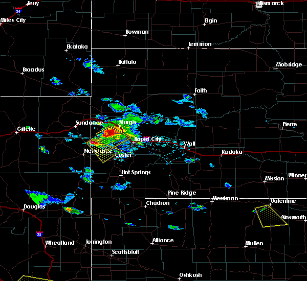 At 505 pm mdt, a severe thunderstorm was located over mallo camp, or 17 miles northeast of newcastle, moving southeast at 30 mph (radar indicated). Hazards include ping pong ball size hail and 60 mph wind gusts. People and animals outdoors will be injured. expect hail damage to roofs, siding, windows, and vehicles. Expect wind damage to roofs, siding, and trees. At 505 pm mdt, a severe thunderstorm was located over mallo camp, or 17 miles northeast of newcastle, moving southeast at 30 mph (radar indicated). Hazards include ping pong ball size hail and 60 mph wind gusts. People and animals outdoors will be injured. expect hail damage to roofs, siding, windows, and vehicles. Expect wind damage to roofs, siding, and trees.
|
| 7/21/2018 6:32 PM MDT |
 A severe thunderstorm warning remains in effect until 715 pm mdt for southwestern pennington county. at 632 pm mdt, a severe thunderstorm was located near sheridan lake, or 6 miles northeast of hill city, moving southeast at 15 mph. hazard. ping pong ball size hail and 60 mph wind gusts. source. Radar indicated. A severe thunderstorm warning remains in effect until 715 pm mdt for southwestern pennington county. at 632 pm mdt, a severe thunderstorm was located near sheridan lake, or 6 miles northeast of hill city, moving southeast at 15 mph. hazard. ping pong ball size hail and 60 mph wind gusts. source. Radar indicated.
|
| 7/21/2018 6:13 PM MDT |
 At 613 pm mdt, a severe thunderstorm was located over pactola reservoir, or 8 miles north of hill city, moving southeast at 15 mph (radar indicated). Hazards include ping pong ball size hail and 60 mph wind gusts. People and animals outdoors will be injured. expect hail damage to roofs, siding, windows, and vehicles. Expect wind damage to roofs, siding, and trees. At 613 pm mdt, a severe thunderstorm was located over pactola reservoir, or 8 miles north of hill city, moving southeast at 15 mph (radar indicated). Hazards include ping pong ball size hail and 60 mph wind gusts. People and animals outdoors will be injured. expect hail damage to roofs, siding, windows, and vehicles. Expect wind damage to roofs, siding, and trees.
|
| 7/17/2018 4:07 PM MDT |
 The severe thunderstorm warning for north central custer and southwestern pennington counties will expire at 415 pm mdt, the storm which prompted the warning has weakened below severe limits, and no longer poses an immediate threat to life or property. therefore, the warning will be allowed to expire. however small hail and heavy rain are still possible with this thunderstorm. a severe thunderstorm watch remains in effect until 1100 pm mdt for southwestern and west central south dakota. The severe thunderstorm warning for north central custer and southwestern pennington counties will expire at 415 pm mdt, the storm which prompted the warning has weakened below severe limits, and no longer poses an immediate threat to life or property. therefore, the warning will be allowed to expire. however small hail and heavy rain are still possible with this thunderstorm. a severe thunderstorm watch remains in effect until 1100 pm mdt for southwestern and west central south dakota.
|
| 7/17/2018 3:54 PM MDT |
 At 354 pm mdt, a severe thunderstorm was located 3 miles northeast of black hills playhouse, or 11 miles southeast of hill city, moving southeast at 10 mph (radar indicated). Hazards include 60 mph wind gusts and half dollar size hail. Hail damage to vehicles is expected. expect wind damage to roofs, siding, and trees. Locations impacted include, hill city, keystone, hayward, mount rushmore national memorial, center lake, keystone wye, black elk peak, sylvan lake, black hills playhouse, horse thief lake, palmer gulch resort and northern custer state park. At 354 pm mdt, a severe thunderstorm was located 3 miles northeast of black hills playhouse, or 11 miles southeast of hill city, moving southeast at 10 mph (radar indicated). Hazards include 60 mph wind gusts and half dollar size hail. Hail damage to vehicles is expected. expect wind damage to roofs, siding, and trees. Locations impacted include, hill city, keystone, hayward, mount rushmore national memorial, center lake, keystone wye, black elk peak, sylvan lake, black hills playhouse, horse thief lake, palmer gulch resort and northern custer state park.
|
| 7/17/2018 3:40 PM MDT |
 At 339 pm mdt, a severe thunderstorm was located over keystone, or 8 miles east of hill city, moving southeast at 5 mph (radar indicated). Hazards include 60 mph wind gusts and half dollar size hail. addionally, lots of small hail could make travel difficult. Hail damage to vehicles is expected. expect wind damage to roofs, siding, and trees. Locations impacted include, hill city, keystone, hayward, mount rushmore national memorial, center lake, keystone wye, black elk peak, sylvan lake, black hills playhouse, horse thief lake, palmer gulch resort and northern custer state park. At 339 pm mdt, a severe thunderstorm was located over keystone, or 8 miles east of hill city, moving southeast at 5 mph (radar indicated). Hazards include 60 mph wind gusts and half dollar size hail. addionally, lots of small hail could make travel difficult. Hail damage to vehicles is expected. expect wind damage to roofs, siding, and trees. Locations impacted include, hill city, keystone, hayward, mount rushmore national memorial, center lake, keystone wye, black elk peak, sylvan lake, black hills playhouse, horse thief lake, palmer gulch resort and northern custer state park.
|
| 7/17/2018 3:28 PM MDT |
 At 327 pm mdt, a severe thunderstorm was located over hill city, moving east at 15 mph (radar indicated. at 310 pm, quarter-sized hail was reported 3 miles wsw of sheridan lake. additionally, lots of small hail has piled up and made travel difficult). Hazards include 60 mph wind gusts and quarter size hail. Hail damage to vehicles is expected. expect wind damage to roofs, siding, and trees. Locations impacted include, hill city, johnson siding, hisega, rockerville, pactola reservoir, sheridan lake and keystone wye. At 327 pm mdt, a severe thunderstorm was located over hill city, moving east at 15 mph (radar indicated. at 310 pm, quarter-sized hail was reported 3 miles wsw of sheridan lake. additionally, lots of small hail has piled up and made travel difficult). Hazards include 60 mph wind gusts and quarter size hail. Hail damage to vehicles is expected. expect wind damage to roofs, siding, and trees. Locations impacted include, hill city, johnson siding, hisega, rockerville, pactola reservoir, sheridan lake and keystone wye.
|
| 7/17/2018 3:25 PM MDT | Quarter sized hail reported 0.9 miles WNW of Hill City, SD, ground is white. 0.75 inches of rain. |
| 7/17/2018 3:22 PM MDT | Half Dollar sized hail reported 2.6 miles WSW of Hill City, SD |
| 7/17/2018 3:21 PM MDT |
 At 321 pm mdt, a severe thunderstorm was located over keystone wye, or 6 miles east of hill city, moving southeast at 5 mph (radar indicated). Hazards include 60 mph wind gusts and half dollar size hail. Hail damage to vehicles is expected. Expect wind damage to roofs, siding, and trees. At 321 pm mdt, a severe thunderstorm was located over keystone wye, or 6 miles east of hill city, moving southeast at 5 mph (radar indicated). Hazards include 60 mph wind gusts and half dollar size hail. Hail damage to vehicles is expected. Expect wind damage to roofs, siding, and trees.
|
| 7/17/2018 3:11 PM MDT |
 At 311 pm mdt, a severe thunderstorm was located over sheridan lake, or 7 miles northeast of hill city, moving east at 5 mph (radar indicated). Hazards include golf ball size hail and 60 mph wind gusts. People and animals outdoors will be injured. expect hail damage to roofs, siding, windows, and vehicles. expect wind damage to roofs, siding, and trees. Locations impacted include, hill city, johnson siding, silver city, hisega, mystic, rockerville, pactola reservoir, sheridan lake and keystone wye. At 311 pm mdt, a severe thunderstorm was located over sheridan lake, or 7 miles northeast of hill city, moving east at 5 mph (radar indicated). Hazards include golf ball size hail and 60 mph wind gusts. People and animals outdoors will be injured. expect hail damage to roofs, siding, windows, and vehicles. expect wind damage to roofs, siding, and trees. Locations impacted include, hill city, johnson siding, silver city, hisega, mystic, rockerville, pactola reservoir, sheridan lake and keystone wye.
|
| 7/17/2018 2:57 PM MDT |
 At 257 pm mdt, a severe thunderstorm was located over sheridan lake, or 5 miles northeast of hill city, moving east at 5 mph (radar indicated). Hazards include ping pong ball size hail and 60 mph wind gusts. People and animals outdoors will be injured. expect hail damage to roofs, siding, windows, and vehicles. Expect wind damage to roofs, siding, and trees. At 257 pm mdt, a severe thunderstorm was located over sheridan lake, or 5 miles northeast of hill city, moving east at 5 mph (radar indicated). Hazards include ping pong ball size hail and 60 mph wind gusts. People and animals outdoors will be injured. expect hail damage to roofs, siding, windows, and vehicles. Expect wind damage to roofs, siding, and trees.
|
| 7/17/2018 2:20 PM MDT | Quarter sized hail reported 10.1 miles SSE of Hill City, SD |
| 7/16/2018 4:36 PM MDT | Golf Ball sized hail reported 5.1 miles N of Hill City, SD, delayed report. time estimated from radar. spotter la33. |
| 7/16/2018 4:35 PM MDT | Quarter sized hail reported 4.4 miles N of Hill City, SD, delayed report. time estimated from radar. spotter la33. |
| 7/16/2018 4:25 PM MDT |
 The national weather service in rapid city has issued a * severe thunderstorm warning for. north central custer county in southwestern south dakota. western pennington county in west central south dakota. Until 500 pm mdt * at 425 pm mdt, a severe thunderstorm was located 3 miles southwest. The national weather service in rapid city has issued a * severe thunderstorm warning for. north central custer county in southwestern south dakota. western pennington county in west central south dakota. Until 500 pm mdt * at 425 pm mdt, a severe thunderstorm was located 3 miles southwest.
|
| 7/3/2018 9:05 PM MDT |
 At 905 pm mdt, severe thunderstorms were located along a line extending from 3 miles north of medicine mountain to 2 miles northeast of custer to 6 miles northwest of argyle, moving northeast at 40 mph (radar indicated). Hazards include 60 mph wind gusts and nickel size hail. Expect damage to roofs, siding, and trees. Locations impacted include, custer, hill city, dewey, keystone, pringle, silver city, mystic, rockerville, deerfield, pactola reservoir, deerfield reservoir, mount rushmore national memorial, stockade lake, legion lake, crazy horse memorial, sheridan lake, blue bell, bear mountain lookout, black hills playhouse and horse thief lake. At 905 pm mdt, severe thunderstorms were located along a line extending from 3 miles north of medicine mountain to 2 miles northeast of custer to 6 miles northwest of argyle, moving northeast at 40 mph (radar indicated). Hazards include 60 mph wind gusts and nickel size hail. Expect damage to roofs, siding, and trees. Locations impacted include, custer, hill city, dewey, keystone, pringle, silver city, mystic, rockerville, deerfield, pactola reservoir, deerfield reservoir, mount rushmore national memorial, stockade lake, legion lake, crazy horse memorial, sheridan lake, blue bell, bear mountain lookout, black hills playhouse and horse thief lake.
|
| 7/3/2018 8:50 PM MDT |
 At 850 pm mdt, severe thunderstorms were located along a line extending from 5 miles southeast of moon to 4 miles east of jewel cave national monument to 5 miles northeast of burdock, moving east at 40 mph (radar indicated). Hazards include 60 mph wind gusts and penny size hail. Expect damage to roofs, siding, and trees. Locations impacted include, custer, hill city, dewey, keystone, pringle, silver city, mystic, moon, rockerville, deerfield, pactola reservoir, deerfield reservoir, mount rushmore national memorial, stockade lake, legion lake, crazy horse memorial, sheridan lake, blue bell, bear mountain lookout and black hills playhouse. At 850 pm mdt, severe thunderstorms were located along a line extending from 5 miles southeast of moon to 4 miles east of jewel cave national monument to 5 miles northeast of burdock, moving east at 40 mph (radar indicated). Hazards include 60 mph wind gusts and penny size hail. Expect damage to roofs, siding, and trees. Locations impacted include, custer, hill city, dewey, keystone, pringle, silver city, mystic, moon, rockerville, deerfield, pactola reservoir, deerfield reservoir, mount rushmore national memorial, stockade lake, legion lake, crazy horse memorial, sheridan lake, blue bell, bear mountain lookout and black hills playhouse.
|
| 7/3/2018 8:23 PM MDT |
 At 823 pm mdt, severe thunderstorms were located along a line extending from near newcastle to 2 miles southwest of elk mountain lookout to 9 miles southeast of morrisey, moving northeast at 40 mph (radar indicated). Hazards include 60 mph wind gusts. expect damage to roofs, siding, and trees At 823 pm mdt, severe thunderstorms were located along a line extending from near newcastle to 2 miles southwest of elk mountain lookout to 9 miles southeast of morrisey, moving northeast at 40 mph (radar indicated). Hazards include 60 mph wind gusts. expect damage to roofs, siding, and trees
|
| 7/3/2018 6:58 PM MDT |
 The severe thunderstorm warning for northwestern custer and southwestern pennington counties will expire at 700 pm mdt, the storms which prompted the warning have weakened below severe limits, and no longer pose an immediate threat to life or property. therefore, the warning will be allowed to expire. however gusty winds are still possible with these thunderstorms. a severe thunderstorm watch remains in effect until midnight mdt for southwestern and west central south dakota. The severe thunderstorm warning for northwestern custer and southwestern pennington counties will expire at 700 pm mdt, the storms which prompted the warning have weakened below severe limits, and no longer pose an immediate threat to life or property. therefore, the warning will be allowed to expire. however gusty winds are still possible with these thunderstorms. a severe thunderstorm watch remains in effect until midnight mdt for southwestern and west central south dakota.
|
| 7/3/2018 6:37 PM MDT |
 At 637 pm mdt, severe thunderstorms were located along a line extending from 5 miles south of deerfield to 5 miles southwest of crazy horse memorial to 6 miles northwest of pringle, moving northeast at 40 mph (radar indicated). Hazards include 60 mph wind gusts and half dollar size hail. Hail damage to vehicles is expected. expect wind damage to roofs, siding, and trees. Locations impacted include, custer, pringle, rochford, deerfield, deerfield reservoir, stockade lake, crazy horse memorial, sylvan lake, medicine mountain, bear mountain lookout, black elk peak, jewel cave national monument, northwestern wind cave national park and western custer state park. At 637 pm mdt, severe thunderstorms were located along a line extending from 5 miles south of deerfield to 5 miles southwest of crazy horse memorial to 6 miles northwest of pringle, moving northeast at 40 mph (radar indicated). Hazards include 60 mph wind gusts and half dollar size hail. Hail damage to vehicles is expected. expect wind damage to roofs, siding, and trees. Locations impacted include, custer, pringle, rochford, deerfield, deerfield reservoir, stockade lake, crazy horse memorial, sylvan lake, medicine mountain, bear mountain lookout, black elk peak, jewel cave national monument, northwestern wind cave national park and western custer state park.
|
| 7/3/2018 6:19 PM MDT |
 At 618 pm mdt, severe thunderstorms were located along a line extending from 2 miles southwest of moon to 5 miles southwest of jewel cave national monument to 7 miles north of edgemont, moving northeast at 35 mph (radar indicated). Hazards include 60 mph wind gusts and quarter size hail. Hail damage to vehicles is expected. expect wind damage to roofs, siding, and trees. Locations impacted include, custer, pringle, rochford, deerfield, argyle, deerfield reservoir, cottonwood springs dam, stockade lake, crazy horse memorial, sylvan lake, medicine mountain, bear mountain lookout, cold brook reservoir, black elk peak, jewel cave national monument, elk mountain lookout, western wind cave national park and western custer state park. At 618 pm mdt, severe thunderstorms were located along a line extending from 2 miles southwest of moon to 5 miles southwest of jewel cave national monument to 7 miles north of edgemont, moving northeast at 35 mph (radar indicated). Hazards include 60 mph wind gusts and quarter size hail. Hail damage to vehicles is expected. expect wind damage to roofs, siding, and trees. Locations impacted include, custer, pringle, rochford, deerfield, argyle, deerfield reservoir, cottonwood springs dam, stockade lake, crazy horse memorial, sylvan lake, medicine mountain, bear mountain lookout, cold brook reservoir, black elk peak, jewel cave national monument, elk mountain lookout, western wind cave national park and western custer state park.
|
| 7/3/2018 6:01 PM MDT |
 At 600 pm mdt, severe thunderstorms were located along a line extending from 5 miles south of newcastle to dewey to 8 miles west of edgemont, moving northeast at 35 mph (radar indicated). Hazards include 60 mph wind gusts and quarter size hail. Hail damage to vehicles is expected. Expect wind damage to roofs, siding, and trees. At 600 pm mdt, severe thunderstorms were located along a line extending from 5 miles south of newcastle to dewey to 8 miles west of edgemont, moving northeast at 35 mph (radar indicated). Hazards include 60 mph wind gusts and quarter size hail. Hail damage to vehicles is expected. Expect wind damage to roofs, siding, and trees.
|
| 6/10/2018 5:35 PM MDT | Quarter sized hail reported 6.4 miles SE of Hill City, SD |
| 5/22/2018 4:03 PM MDT | Quarter sized hail reported 15 miles SSE of Hill City, SD |
| 5/22/2018 3:43 PM MDT | Quarter sized hail reported 14.6 miles SSE of Hill City, SD |
| 5/22/2018 3:40 PM MDT | Golf Ball sized hail reported 16.3 miles SSE of Hill City, SD, golf ball hail started around 3:40 pm... became smaller with pea hail ending around 4:00 pm. hail covering the ground... looks like snow. |
| 7/11/2017 9:28 PM MDT |
 At 928 pm mdt, a severe thunderstorm was located over roubaix lake, or 9 miles southeast of lead, moving east at 40 mph (radar indicated). Hazards include 60 mph wind gusts and penny size hail. Expect damage to roofs, siding, and trees. Locations impacted include, southern spearfish, sturgis, lead, hill city, deadwood, whitewood, nemo, piedmont, central city, silver city, rochford, mystic, brownsville, galena, tilford, cheyenne crossing, flag mountain, deerfield reservoir, pactola reservoir, and roughlock falls. At 928 pm mdt, a severe thunderstorm was located over roubaix lake, or 9 miles southeast of lead, moving east at 40 mph (radar indicated). Hazards include 60 mph wind gusts and penny size hail. Expect damage to roofs, siding, and trees. Locations impacted include, southern spearfish, sturgis, lead, hill city, deadwood, whitewood, nemo, piedmont, central city, silver city, rochford, mystic, brownsville, galena, tilford, cheyenne crossing, flag mountain, deerfield reservoir, pactola reservoir, and roughlock falls.
|
| 7/11/2017 9:02 PM MDT |
 At 902 pm mdt, a severe thunderstorm was located near iron creek lake, or 12 miles west of lead, moving east at 45 mph (radar indicated). Hazards include 60 mph wind gusts and quarter size hail. Hail damage to vehicles is expected. Expect wind damage to roofs, siding, and trees. At 902 pm mdt, a severe thunderstorm was located near iron creek lake, or 12 miles west of lead, moving east at 45 mph (radar indicated). Hazards include 60 mph wind gusts and quarter size hail. Hail damage to vehicles is expected. Expect wind damage to roofs, siding, and trees.
|
| 6/28/2017 11:07 AM MDT |
 At 507 pm mdt, a severe thunderstorm was located over sheridan lake, or near hill city, moving east at 25 mph (radar indicated). Hazards include two inch hail. People and animals outdoors will be injured. expect damage to roofs, siding, windows, and vehicles. Locations impacted include, southern rapid city, hill city, southwestern rapid valley, hisega, rockerville, sheridan lake, bear country, keystone wye, hart ranch, black gap and reptile gardens. At 507 pm mdt, a severe thunderstorm was located over sheridan lake, or near hill city, moving east at 25 mph (radar indicated). Hazards include two inch hail. People and animals outdoors will be injured. expect damage to roofs, siding, windows, and vehicles. Locations impacted include, southern rapid city, hill city, southwestern rapid valley, hisega, rockerville, sheridan lake, bear country, keystone wye, hart ranch, black gap and reptile gardens.
|
| 6/28/2017 10:56 AM MDT |
 At 455 pm mdt, a severe thunderstorm was located near hill city, moving east at 25 mph (radar indicated). Hazards include golf ball size hail. People and animals outdoors will be injured. expect damage to roofs, siding, windows, and vehicles. Locations impacted include, southern rapid city, hill city, southwestern rapid valley, keystone, hisega, mystic, rockerville, hayward, pactola reservoir, bear country, keystone wye, hart ranch, sheridan lake, black gap and reptile gardens. At 455 pm mdt, a severe thunderstorm was located near hill city, moving east at 25 mph (radar indicated). Hazards include golf ball size hail. People and animals outdoors will be injured. expect damage to roofs, siding, windows, and vehicles. Locations impacted include, southern rapid city, hill city, southwestern rapid valley, keystone, hisega, mystic, rockerville, hayward, pactola reservoir, bear country, keystone wye, hart ranch, sheridan lake, black gap and reptile gardens.
|
| 6/28/2017 10:46 AM MDT |
 At 445 pm mdt, a severe thunderstorm was located near mystic, or 7 miles northwest of hill city, moving east at 25 mph (radar indicated). Hazards include half dollar size hail. damage to vehicles is expected At 445 pm mdt, a severe thunderstorm was located near mystic, or 7 miles northwest of hill city, moving east at 25 mph (radar indicated). Hazards include half dollar size hail. damage to vehicles is expected
|
| 6/27/2017 11:10 AM MDT |
 At 508 pm mdt, severe thunderstorms were located along a line extending from near mystic to near fairburn to near smithwick, moving east at 50 mph (radar indicated. this line of storms has a history of producing winds in excess of 65 mph). Hazards include 70 mph wind gusts and quarter size hail. Hail damage to vehicles is expected. expect considerable tree damage. wind damage is also likely to mobile homes, roofs, and outbuildings. Locations impacted include, rapid city, hot springs, custer, hill city, rapid valley, southern ellsworth air force base, box elder, black hawk, johnson siding, hermosa, keystone, oral, buffalo gap, hisega, fairburn, smithwick, rockerville, farmingdale, rockyford and folsom. At 508 pm mdt, severe thunderstorms were located along a line extending from near mystic to near fairburn to near smithwick, moving east at 50 mph (radar indicated. this line of storms has a history of producing winds in excess of 65 mph). Hazards include 70 mph wind gusts and quarter size hail. Hail damage to vehicles is expected. expect considerable tree damage. wind damage is also likely to mobile homes, roofs, and outbuildings. Locations impacted include, rapid city, hot springs, custer, hill city, rapid valley, southern ellsworth air force base, box elder, black hawk, johnson siding, hermosa, keystone, oral, buffalo gap, hisega, fairburn, smithwick, rockerville, farmingdale, rockyford and folsom.
|
| 6/27/2017 10:59 AM MDT |
 At 459 pm mdt, severe thunderstorms were located along a line extending from near deerfield reservoir to wind cave national park to smithwick, moving east at 50 mph (radar indicated). Hazards include 60 mph wind gusts and quarter size hail. Hail damage to vehicles is expected. expect wind damage to roofs, siding, and trees. Locations impacted include, rapid city, hot springs, custer, hill city, rapid valley, southern ellsworth air force base, box elder, black hawk, johnson siding, hermosa, keystone, oral, buffalo gap, pringle, hisega, fairburn, smithwick, rockerville, farmingdale and rockyford. At 459 pm mdt, severe thunderstorms were located along a line extending from near deerfield reservoir to wind cave national park to smithwick, moving east at 50 mph (radar indicated). Hazards include 60 mph wind gusts and quarter size hail. Hail damage to vehicles is expected. expect wind damage to roofs, siding, and trees. Locations impacted include, rapid city, hot springs, custer, hill city, rapid valley, southern ellsworth air force base, box elder, black hawk, johnson siding, hermosa, keystone, oral, buffalo gap, pringle, hisega, fairburn, smithwick, rockerville, farmingdale and rockyford.
|
| 6/27/2017 10:47 AM MDT |
 At 446 pm mdt, severe thunderstorms were located along a line extending from near redbank spring campground to near sanator to near maverick junction, moving east at 50 mph (radar indicated). Hazards include 60 mph wind gusts and penny size hail. expect damage to roofs, siding, and trees At 446 pm mdt, severe thunderstorms were located along a line extending from near redbank spring campground to near sanator to near maverick junction, moving east at 50 mph (radar indicated). Hazards include 60 mph wind gusts and penny size hail. expect damage to roofs, siding, and trees
|
| 6/7/2017 4:34 PM MDT | Quarter sized hail reported 14.8 miles ESE of Hill City, SD |
| 6/7/2017 2:57 PM MDT |
 The severe thunderstorm warning for southwestern pennington county will expire at 300 pm mdt, the storm which prompted the warning has weakened below severe limits, and no longer poses an immediate threat to life or property. therefore the warning will be allowed to expire. The severe thunderstorm warning for southwestern pennington county will expire at 300 pm mdt, the storm which prompted the warning has weakened below severe limits, and no longer poses an immediate threat to life or property. therefore the warning will be allowed to expire.
|
| 6/7/2017 2:47 PM MDT |
 At 246 pm mdt, a severe thunderstorm was located over hill city, moving southeast at 15 mph (radar indicated). Hazards include quarter size hail. Damage to vehicles is expected. Locations impacted include, hill city, sheridan lake, keystone wye and mount rushmore koa. At 246 pm mdt, a severe thunderstorm was located over hill city, moving southeast at 15 mph (radar indicated). Hazards include quarter size hail. Damage to vehicles is expected. Locations impacted include, hill city, sheridan lake, keystone wye and mount rushmore koa.
|
| 6/7/2017 2:31 PM MDT |
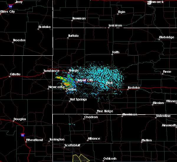 At 230 pm mdt, a severe thunderstorm was located near hill city, moving southeast at 15 mph (radar indicated). Hazards include quarter size hail. Damage to vehicles is expected. Locations impacted include, hill city, mystic, pactola reservoir, sheridan lake, keystone wye and mount rushmore koa. At 230 pm mdt, a severe thunderstorm was located near hill city, moving southeast at 15 mph (radar indicated). Hazards include quarter size hail. Damage to vehicles is expected. Locations impacted include, hill city, mystic, pactola reservoir, sheridan lake, keystone wye and mount rushmore koa.
|
| 6/7/2017 2:16 PM MDT |
 At 216 pm mdt, a severe thunderstorm was located near mystic, or near hill city, moving south at 15 mph (radar indicated). Hazards include 60 mph wind gusts and quarter size hail. Hail damage to vehicles is expected. expect wind damage to roofs, siding, and trees. Locations impacted include, hill city, silver city, mystic, pactola reservoir, sheridan lake, keystone wye and mount rushmore koa. At 216 pm mdt, a severe thunderstorm was located near mystic, or near hill city, moving south at 15 mph (radar indicated). Hazards include 60 mph wind gusts and quarter size hail. Hail damage to vehicles is expected. expect wind damage to roofs, siding, and trees. Locations impacted include, hill city, silver city, mystic, pactola reservoir, sheridan lake, keystone wye and mount rushmore koa.
|
| 6/7/2017 1:58 PM MDT |
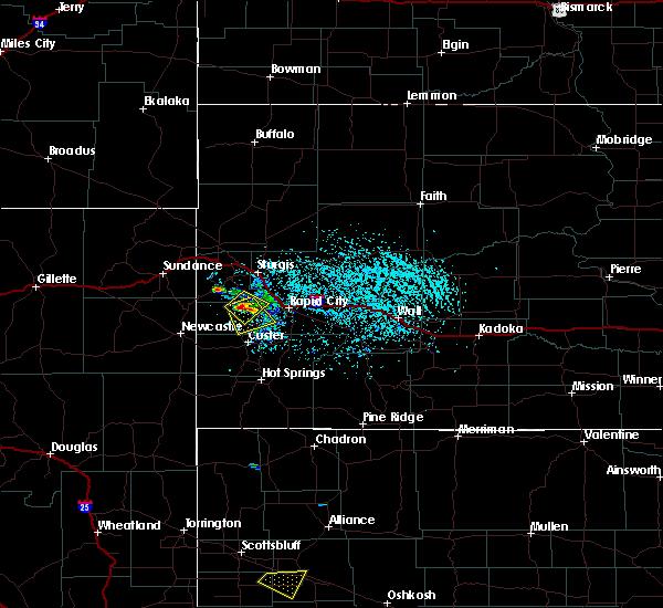 At 157 pm mdt, a severe thunderstorm was located over mystic, or 9 miles north of hill city, moving southeast at 10 mph (radar indicated). Hazards include 60 mph wind gusts and quarter size hail. Hail damage to vehicles is expected. Expect wind damage to roofs, siding, and trees. At 157 pm mdt, a severe thunderstorm was located over mystic, or 9 miles north of hill city, moving southeast at 10 mph (radar indicated). Hazards include 60 mph wind gusts and quarter size hail. Hail damage to vehicles is expected. Expect wind damage to roofs, siding, and trees.
|
| 6/7/2017 1:55 PM MDT | Quarter sized hail reported 13 miles SSE of Hill City, SD, ground is covered in hail |
| 6/5/2017 4:46 PM MDT |
 At 446 pm mdt, a severe thunderstorm was located over horsethief lake, or near hill city, moving southeast at 10 mph (radar indicated). Hazards include quarter size hail. damage to vehicles is expected At 446 pm mdt, a severe thunderstorm was located over horsethief lake, or near hill city, moving southeast at 10 mph (radar indicated). Hazards include quarter size hail. damage to vehicles is expected
|
| 6/5/2017 4:42 PM MDT | Quarter sized hail reported 0.7 miles ENE of Hill City, SD |
| 6/5/2017 4:42 PM MDT | Quarter sized hail reported 2.2 miles SSE of Hill City, SD |
| 6/5/2017 4:42 PM MDT | Quarter sized hail reported 2.7 miles SSW of Hill City, SD |
| 6/5/2017 4:34 PM MDT |
 At 434 pm mdt, a severe thunderstorm was located near hill city, and is nearly stationary (radar indicated). Hazards include quarter size hail. Damage to vehicles is expected. Locations impacted include, hill city, sheridan lake and mount rushmore koa. At 434 pm mdt, a severe thunderstorm was located near hill city, and is nearly stationary (radar indicated). Hazards include quarter size hail. Damage to vehicles is expected. Locations impacted include, hill city, sheridan lake and mount rushmore koa.
|
| 6/5/2017 4:10 PM MDT |
 At 409 pm mdt, a severe thunderstorm was located near hill city, moving east at 5 mph (radar indicated). Hazards include 60 mph wind gusts and quarter size hail. Hail damage to vehicles is expected. Expect wind damage to roofs, siding, and trees. At 409 pm mdt, a severe thunderstorm was located near hill city, moving east at 5 mph (radar indicated). Hazards include 60 mph wind gusts and quarter size hail. Hail damage to vehicles is expected. Expect wind damage to roofs, siding, and trees.
|
| 8/15/2016 3:48 PM MDT |
 At 348 pm mdt, a severe thunderstorm was located over crazy horse memorial, or near custer, moving south at 15 mph (radar indicated). Hazards include half dollar size hail. Damage to vehicles is expected. this severe storm will be near, northern custer state park around 355 pm mdt. custer and stockade lake around 415 pm mdt. Legion lake around 420 pm mdt. At 348 pm mdt, a severe thunderstorm was located over crazy horse memorial, or near custer, moving south at 15 mph (radar indicated). Hazards include half dollar size hail. Damage to vehicles is expected. this severe storm will be near, northern custer state park around 355 pm mdt. custer and stockade lake around 415 pm mdt. Legion lake around 420 pm mdt.
|
| 8/15/2016 3:34 PM MDT |
 At 333 pm mdt, severe thunderstorms were located along a line extending from rockerville to near bear mountain lookout, moving southeast at 10 mph (radar indicated). Hazards include golf ball size hail. People and animals outdoors will be injured. expect damage to roofs, siding, windows, and vehicles. Locations impacted include, custer, hill city, keystone, hayward, rockerville, keystone wye, horsethief lake, bear mountain lookout, sylvan lake, center lake, stockade lake, sheridan lake, mount rushmore koa, crazy horse memorial, mount rushmore national memorial, harney peak, legion lake, custer park game lodge and northern custer state park. At 333 pm mdt, severe thunderstorms were located along a line extending from rockerville to near bear mountain lookout, moving southeast at 10 mph (radar indicated). Hazards include golf ball size hail. People and animals outdoors will be injured. expect damage to roofs, siding, windows, and vehicles. Locations impacted include, custer, hill city, keystone, hayward, rockerville, keystone wye, horsethief lake, bear mountain lookout, sylvan lake, center lake, stockade lake, sheridan lake, mount rushmore koa, crazy horse memorial, mount rushmore national memorial, harney peak, legion lake, custer park game lodge and northern custer state park.
|
| 8/15/2016 3:24 PM MDT |
 At 323 pm mdt, severe thunderstorms were located along a line extending from rockerville to near bear mountain lookout, moving south at 10 mph (radar indicated). Hazards include ping pong ball size hail. People and animals outdoors will be injured. expect damage to roofs, siding, windows, and vehicles. Locations impacted include, custer, hill city, keystone, hayward, rockerville, keystone wye, horsethief lake, bear mountain lookout, sylvan lake, center lake, stockade lake, sheridan lake, mount rushmore koa, crazy horse memorial, mount rushmore national memorial, harney peak, legion lake, custer park game lodge and northern custer state park. At 323 pm mdt, severe thunderstorms were located along a line extending from rockerville to near bear mountain lookout, moving south at 10 mph (radar indicated). Hazards include ping pong ball size hail. People and animals outdoors will be injured. expect damage to roofs, siding, windows, and vehicles. Locations impacted include, custer, hill city, keystone, hayward, rockerville, keystone wye, horsethief lake, bear mountain lookout, sylvan lake, center lake, stockade lake, sheridan lake, mount rushmore koa, crazy horse memorial, mount rushmore national memorial, harney peak, legion lake, custer park game lodge and northern custer state park.
|
| 8/15/2016 3:12 PM MDT |
 At 311 pm mdt, a severe thunderstorm was located over hill city, moving southeast at 15 mph (radar indicated). Hazards include quarter size hail. damage to vehicles is expected At 311 pm mdt, a severe thunderstorm was located over hill city, moving southeast at 15 mph (radar indicated). Hazards include quarter size hail. damage to vehicles is expected
|
| 8/15/2016 2:42 PM MDT |
 At 241 pm mdt, a severe thunderstorm was located over harney peak, or near hill city, moving east at 10 mph (trained weather spotters). Hazards include quarter size hail. Damage to vehicles is expected. Locations impacted include, harney peak, legion lake, custer state park, sylvan lake, custer park game lodge, center lake, stockade lake, blue bell, mount rushmore koa, horsethief lake and mount rushmore national memorial. At 241 pm mdt, a severe thunderstorm was located over harney peak, or near hill city, moving east at 10 mph (trained weather spotters). Hazards include quarter size hail. Damage to vehicles is expected. Locations impacted include, harney peak, legion lake, custer state park, sylvan lake, custer park game lodge, center lake, stockade lake, blue bell, mount rushmore koa, horsethief lake and mount rushmore national memorial.
|
| 8/15/2016 2:25 PM MDT |
 At 225 pm mdt, a severe thunderstorm was located over northwestern custer state park, or near custer, moving southeast at 10 mph (radar indicated). Hazards include 60 mph wind gusts and quarter size hail. Hail damage to vehicles is expected. Expect wind damage to roofs, siding, and trees. At 225 pm mdt, a severe thunderstorm was located over northwestern custer state park, or near custer, moving southeast at 10 mph (radar indicated). Hazards include 60 mph wind gusts and quarter size hail. Hail damage to vehicles is expected. Expect wind damage to roofs, siding, and trees.
|
| 8/8/2016 5:58 PM MDT |
 At 558 pm mdt, severe thunderstorms were located along a line extending from near mystic to near hisega, moving southeast at 10 mph (radar indicated). Hazards include golf ball size hail. People and animals outdoors will be injured. Expect damage to roofs, siding, windows, and vehicles. At 558 pm mdt, severe thunderstorms were located along a line extending from near mystic to near hisega, moving southeast at 10 mph (radar indicated). Hazards include golf ball size hail. People and animals outdoors will be injured. Expect damage to roofs, siding, windows, and vehicles.
|
| 8/1/2016 3:01 PM MDT | Hen Egg sized hail reported 13 miles SSE of Hill City, SD |
| 8/1/2016 2:40 PM MDT |
 At 239 pm mdt, a severe thunderstorm was located near crazy horse memorial, or 8 miles southwest of hill city, moving east at 10 mph (trained weather spotters. at 230 pm mdt...quarter size hail was reported 8 miles west southwest of hill city). Hazards include quarter size hail. Damage to vehicles is expected. Locations impacted include, crazy horse memorial, mount rushmore koa and sylvan lake. At 239 pm mdt, a severe thunderstorm was located near crazy horse memorial, or 8 miles southwest of hill city, moving east at 10 mph (trained weather spotters. at 230 pm mdt...quarter size hail was reported 8 miles west southwest of hill city). Hazards include quarter size hail. Damage to vehicles is expected. Locations impacted include, crazy horse memorial, mount rushmore koa and sylvan lake.
|
| 8/1/2016 2:27 PM MDT |
 At 226 pm mdt, a severe thunderstorm was located 7 miles northwest of crazy horse memorial, or 9 miles west of hill city, moving east at 10 mph (radar indicated). Hazards include quarter size hail. damage to vehicles is expected At 226 pm mdt, a severe thunderstorm was located 7 miles northwest of crazy horse memorial, or 9 miles west of hill city, moving east at 10 mph (radar indicated). Hazards include quarter size hail. damage to vehicles is expected
|
| 7/31/2016 6:11 PM MDT | Quarter sized hail reported 0.7 miles ENE of Hill City, SD |
| 7/31/2016 6:08 PM MDT |
 At 608 pm mdt, a severe thunderstorm was located over hill city, moving southeast at 20 mph (radar indicated). Hazards include 60 mph wind gusts and quarter size hail. Hail damage to vehicles is expected. expect wind damage to roofs, siding, and trees. Locations impacted include, hill city, keystone, hayward, keystone wye, mount rushmore national memorial, harney peak, horsethief lake and mount rushmore koa. At 608 pm mdt, a severe thunderstorm was located over hill city, moving southeast at 20 mph (radar indicated). Hazards include 60 mph wind gusts and quarter size hail. Hail damage to vehicles is expected. expect wind damage to roofs, siding, and trees. Locations impacted include, hill city, keystone, hayward, keystone wye, mount rushmore national memorial, harney peak, horsethief lake and mount rushmore koa.
|
| 7/31/2016 5:54 PM MDT |
 At 554 pm mdt, a severe thunderstorm was located near hill city, moving southeast at 20 mph (radar indicated). Hazards include golf ball size hail and 60 mph wind gusts. People and animals outdoors will be injured. expect hail damage to roofs, siding, windows, and vehicles. expect wind damage to roofs, siding, and trees. Locations impacted include, hill city, keystone, hayward, mystic, keystone wye, mount rushmore national memorial, harney peak, horsethief lake, sheridan lake and mount rushmore koa. At 554 pm mdt, a severe thunderstorm was located near hill city, moving southeast at 20 mph (radar indicated). Hazards include golf ball size hail and 60 mph wind gusts. People and animals outdoors will be injured. expect hail damage to roofs, siding, windows, and vehicles. expect wind damage to roofs, siding, and trees. Locations impacted include, hill city, keystone, hayward, mystic, keystone wye, mount rushmore national memorial, harney peak, horsethief lake, sheridan lake and mount rushmore koa.
|
| 7/31/2016 5:47 PM MDT |
 At 546 pm mdt, a severe thunderstorm was located near deerfield reservoir, or 7 miles northwest of hill city, moving southeast at 20 mph (radar indicated). Hazards include 60 mph wind gusts and quarter size hail. Hail damage to vehicles is expected. Expect wind damage to roofs, siding, and trees. At 546 pm mdt, a severe thunderstorm was located near deerfield reservoir, or 7 miles northwest of hill city, moving southeast at 20 mph (radar indicated). Hazards include 60 mph wind gusts and quarter size hail. Hail damage to vehicles is expected. Expect wind damage to roofs, siding, and trees.
|
| 7/30/2016 8:12 PM MDT |
 At 810 pm mdt, a severe thunderstorm was located near rockerville or 10 miles south-southwest of rapid city, moving southeast at 35 mph (radar indicated). Hazards include 60 mph wind gusts and quarter size hail. Hail damage to vehicles is expected. expect wind damage to roofs, siding, and trees. Locations impacted include, southwestern rapid city, hill city, hermosa, keystone, hisega, hayward, rockerville, keystone wye, pactola reservoir, horsethief lake, reptile gardens, sheridan lake, mount rushmore koa, bear country and mount rushmore national memorial. At 810 pm mdt, a severe thunderstorm was located near rockerville or 10 miles south-southwest of rapid city, moving southeast at 35 mph (radar indicated). Hazards include 60 mph wind gusts and quarter size hail. Hail damage to vehicles is expected. expect wind damage to roofs, siding, and trees. Locations impacted include, southwestern rapid city, hill city, hermosa, keystone, hisega, hayward, rockerville, keystone wye, pactola reservoir, horsethief lake, reptile gardens, sheridan lake, mount rushmore koa, bear country and mount rushmore national memorial.
|
| 7/30/2016 8:09 PM MDT |
 At 808 pm mdt, a severe thunderstorm was located near jewel cave national monument, or 8 miles west of custer, moving southeast at 35 mph (trained weather spotters. at 756 pm mdt...quarter sized hail and 60 mph wind gusts were reported 3 miles north of newcastle). Hazards include ping pong ball size hail and 60 mph wind gusts. People and animals outdoors will be injured. expect hail damage to roofs, siding, windows, and vehicles. expect wind damage to roofs, siding, and trees. Locations impacted include, custer, pringle, sanator, argyle, horsethief lake, custer state park, sylvan lake, center lake, stockade lake, mount rushmore koa, jewel cave national monument, crazy horse memorial, mount rushmore national memorial, harney peak, legion lake, custer park game lodge, wind cave visitors center, wind cave national park and blue bell. At 808 pm mdt, a severe thunderstorm was located near jewel cave national monument, or 8 miles west of custer, moving southeast at 35 mph (trained weather spotters. at 756 pm mdt...quarter sized hail and 60 mph wind gusts were reported 3 miles north of newcastle). Hazards include ping pong ball size hail and 60 mph wind gusts. People and animals outdoors will be injured. expect hail damage to roofs, siding, windows, and vehicles. expect wind damage to roofs, siding, and trees. Locations impacted include, custer, pringle, sanator, argyle, horsethief lake, custer state park, sylvan lake, center lake, stockade lake, mount rushmore koa, jewel cave national monument, crazy horse memorial, mount rushmore national memorial, harney peak, legion lake, custer park game lodge, wind cave visitors center, wind cave national park and blue bell.
|
| 7/30/2016 7:45 PM MDT |
 At 744 pm mdt, a severe thunderstorm was located over mystic, or 7 miles north of hill city, moving east at 35 mph (radar indicated). Hazards include ping pong ball size hail and 60 mph wind gusts. People and animals outdoors will be injured. expect hail damage to roofs, siding, windows, and vehicles. Expect wind damage to roofs, siding, and trees. At 744 pm mdt, a severe thunderstorm was located over mystic, or 7 miles north of hill city, moving east at 35 mph (radar indicated). Hazards include ping pong ball size hail and 60 mph wind gusts. People and animals outdoors will be injured. expect hail damage to roofs, siding, windows, and vehicles. Expect wind damage to roofs, siding, and trees.
|
| 7/30/2016 7:38 PM MDT |
 At 738 pm mdt, a severe thunderstorm was located over moon, or 9 miles northeast of newcastle, moving southeast at 40 mph (radar indicated). Hazards include 60 mph wind gusts and quarter size hail. Hail damage to vehicles is expected. Expect wind damage to roofs, siding, and trees. At 738 pm mdt, a severe thunderstorm was located over moon, or 9 miles northeast of newcastle, moving southeast at 40 mph (radar indicated). Hazards include 60 mph wind gusts and quarter size hail. Hail damage to vehicles is expected. Expect wind damage to roofs, siding, and trees.
|
| 7/29/2016 3:45 PM MDT | Golf Ball sized hail reported 4.4 miles N of Hill City, SD |
| 7/29/2016 3:43 PM MDT |
 At 343 pm mdt, a severe thunderstorm was located over sylvan lake, or near hill city, moving southeast at 25 mph (radar indicated). Hazards include ping pong ball size hail. People and animals outdoors will be injured. Expect damage to roofs, siding, windows, and vehicles. At 343 pm mdt, a severe thunderstorm was located over sylvan lake, or near hill city, moving southeast at 25 mph (radar indicated). Hazards include ping pong ball size hail. People and animals outdoors will be injured. Expect damage to roofs, siding, windows, and vehicles.
|
| 7/29/2016 3:29 PM MDT |
 At 329 pm mdt, a severe thunderstorm was located over keystone wye, or 5 miles east of hill city, moving southeast at 20 mph (radar indicated). Hazards include two inch hail. People and animals outdoors will be injured. expect damage to roofs, siding, windows, and vehicles. Locations impacted include, keystone, hayward, keystone wye, mount rushmore national memorial, horsethief lake, legion lake, custer state park, custer park game lodge, center lake, sheridan lake and mount rushmore koa. At 329 pm mdt, a severe thunderstorm was located over keystone wye, or 5 miles east of hill city, moving southeast at 20 mph (radar indicated). Hazards include two inch hail. People and animals outdoors will be injured. expect damage to roofs, siding, windows, and vehicles. Locations impacted include, keystone, hayward, keystone wye, mount rushmore national memorial, horsethief lake, legion lake, custer state park, custer park game lodge, center lake, sheridan lake and mount rushmore koa.
|
| 7/29/2016 3:15 PM MDT |
 At 315 pm mdt, a severe thunderstorm was located over sheridan lake, or near hill city, moving southeast at 15 mph (radar indicated). Hazards include half dollar size hail. damage to vehicles is expected At 315 pm mdt, a severe thunderstorm was located over sheridan lake, or near hill city, moving southeast at 15 mph (radar indicated). Hazards include half dollar size hail. damage to vehicles is expected
|
| 7/18/2016 5:12 PM MDT |
 At 512 pm mdt, a severe thunderstorm was located over custer, moving northeast at 40 mph (radar indicated). Hazards include 70 mph wind gusts and nickel size hail. Expect considerable tree damage. Damage is likely to mobile homes, roofs, and outbuildings. At 512 pm mdt, a severe thunderstorm was located over custer, moving northeast at 40 mph (radar indicated). Hazards include 70 mph wind gusts and nickel size hail. Expect considerable tree damage. Damage is likely to mobile homes, roofs, and outbuildings.
|
| 6/28/2016 4:01 PM MDT |
 At 401 pm mdt, severe thunderstorms were located along a line extending from nemo to johnson siding to near hill city, moving southeast at 50 mph (radar indicated). Hazards include 60 mph wind gusts. Expect damage to roofs. siding. And trees. At 401 pm mdt, severe thunderstorms were located along a line extending from nemo to johnson siding to near hill city, moving southeast at 50 mph (radar indicated). Hazards include 60 mph wind gusts. Expect damage to roofs. siding. And trees.
|
| 6/28/2016 3:10 PM MDT |
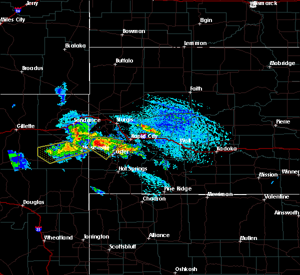 At 309 pm mdt, a severe thunderstorm was located near deerfield reservoir, or 13 miles west of hill city, moving southeast at 25 mph (radar indicated). Hazards include golf ball size hail and 60 mph wind gusts. People and animals outdoors will be injured. expect hail damage to roofs, siding, windows, and vehicles. expect wind damage to roofs, siding, and trees. Locations impacted include, moon, mystic, deerfield, and deerfield reservoir. At 309 pm mdt, a severe thunderstorm was located near deerfield reservoir, or 13 miles west of hill city, moving southeast at 25 mph (radar indicated). Hazards include golf ball size hail and 60 mph wind gusts. People and animals outdoors will be injured. expect hail damage to roofs, siding, windows, and vehicles. expect wind damage to roofs, siding, and trees. Locations impacted include, moon, mystic, deerfield, and deerfield reservoir.
|
| 6/28/2016 2:55 PM MDT |
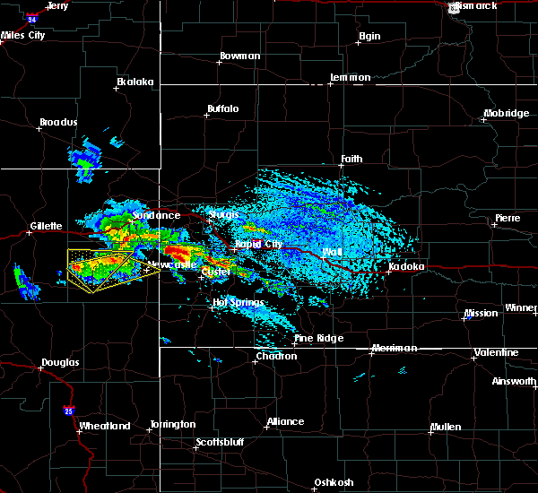 At 254 pm mdt, a severe thunderstorm was located near deerfield, or 19 miles northwest of hill city, moving southeast at 25 mph (radar indicated). Hazards include half dollar size hail. damage to vehicles is expected At 254 pm mdt, a severe thunderstorm was located near deerfield, or 19 miles northwest of hill city, moving southeast at 25 mph (radar indicated). Hazards include half dollar size hail. damage to vehicles is expected
|
| 6/9/2016 9:12 PM MDT |
 At 911 pm mdt, severe thunderstorms were located along a line extending from near roubaix lake to near hill city, moving east at 30 mph (radar indicated). Hazards include 60 mph wind gusts and nickel size hail. Expect damage to roofs. siding. and trees. Locations impacted include, hill city, johnson siding, nemo, keystone, silver city, rochford, mystic, pactola reservoir, mount rushmore national memorial, harney peak, roubaix lake and sheridan lake. At 911 pm mdt, severe thunderstorms were located along a line extending from near roubaix lake to near hill city, moving east at 30 mph (radar indicated). Hazards include 60 mph wind gusts and nickel size hail. Expect damage to roofs. siding. and trees. Locations impacted include, hill city, johnson siding, nemo, keystone, silver city, rochford, mystic, pactola reservoir, mount rushmore national memorial, harney peak, roubaix lake and sheridan lake.
|
| 6/9/2016 8:50 PM MDT |
 At 850 pm mdt, severe thunderstorms were located along a line extending from near rochford to 8 miles south of deerfield reservoir, moving east at 25 mph (radar indicated). Hazards include 60 mph wind gusts and nickel size hail. Expect damage to roofs. siding. And trees. At 850 pm mdt, severe thunderstorms were located along a line extending from near rochford to 8 miles south of deerfield reservoir, moving east at 25 mph (radar indicated). Hazards include 60 mph wind gusts and nickel size hail. Expect damage to roofs. siding. And trees.
|
| 5/20/2016 8:31 PM MDT | Ping Pong Ball sized hail reported 0.3 miles NNE of Hill City, SD, quarter to ping pong ball size hail |
| 8/26/2015 9:15 PM MDT |
 At 915 pm mdt, a severe thunderstorm was located 7 miles west of hill city, moving east at 30 mph (radar indicated). Hazards include 60 mph wind gusts and penny size hail. Expect damage to roofs. siding and trees. Locations impacted include, hill city and deerfield reservoir. At 915 pm mdt, a severe thunderstorm was located 7 miles west of hill city, moving east at 30 mph (radar indicated). Hazards include 60 mph wind gusts and penny size hail. Expect damage to roofs. siding and trees. Locations impacted include, hill city and deerfield reservoir.
|
| 8/26/2015 9:00 PM MDT |
 At 900 pm mdt, a severe thunderstorm was located near moon, or 15 miles east of newcastle, moving northeast at 40 mph (radar indicated). Hazards include 60 mph wind gusts and penny size hail. Expect damage to roofs. siding and trees. Locations impacted include, hill city and deerfield reservoir. At 900 pm mdt, a severe thunderstorm was located near moon, or 15 miles east of newcastle, moving northeast at 40 mph (radar indicated). Hazards include 60 mph wind gusts and penny size hail. Expect damage to roofs. siding and trees. Locations impacted include, hill city and deerfield reservoir.
|
| 8/26/2015 8:48 PM MDT |
 At 847 pm mdt, a severe thunderstorm was located 7 miles southwest of moon, or 7 miles east of newcastle, moving northeast at 25 mph (radar indicated). Hazards include 60 mph wind gusts and nickel size hail. Expect damage to roofs. Siding and trees. At 847 pm mdt, a severe thunderstorm was located 7 miles southwest of moon, or 7 miles east of newcastle, moving northeast at 25 mph (radar indicated). Hazards include 60 mph wind gusts and nickel size hail. Expect damage to roofs. Siding and trees.
|
| 8/11/2015 6:21 PM MDT |
 The severe thunderstorm warning for western pennington county will expire at 630 pm mdt, the storm which prompted the warning has weakened below severe limits, and no longer poses an immediate threat to life or property. therefore the warning will be allowed to expire. The severe thunderstorm warning for western pennington county will expire at 630 pm mdt, the storm which prompted the warning has weakened below severe limits, and no longer poses an immediate threat to life or property. therefore the warning will be allowed to expire.
|
| 8/11/2015 6:12 PM MDT |
 At 611 pm mdt, a severe thunderstorm was located over mount rushmore national memorial, or near hill city, moving southeast at 10 mph (radar indicated. at 609 pm mdt penny size hail was reported at sheridan lake marina). Hazards include quarter size hail. Damage to vehicles is expected. Locations impacted include, hill city, keystone, sheridan lake and mount rushmore national memorial. At 611 pm mdt, a severe thunderstorm was located over mount rushmore national memorial, or near hill city, moving southeast at 10 mph (radar indicated. at 609 pm mdt penny size hail was reported at sheridan lake marina). Hazards include quarter size hail. Damage to vehicles is expected. Locations impacted include, hill city, keystone, sheridan lake and mount rushmore national memorial.
|
| 8/11/2015 6:03 PM MDT |
 At 602 pm mdt, a severe thunderstorm was located over mount rushmore national memorial, or near hill city, moving south at 10 mph (radar indicated). Hazards include half dollar size hail. Damage to vehicles is expected. Locations impacted include, harney peak, hill city, keystone, sheridan lake and mount rushmore national memorial. At 602 pm mdt, a severe thunderstorm was located over mount rushmore national memorial, or near hill city, moving south at 10 mph (radar indicated). Hazards include half dollar size hail. Damage to vehicles is expected. Locations impacted include, harney peak, hill city, keystone, sheridan lake and mount rushmore national memorial.
|
| 8/11/2015 5:58 PM MDT |
 At 557 pm mdt, a severe thunderstorm was located over sheridan lake, or near hill city, moving southeast at 15 mph (radar indicated). Hazards include quarter size hail. Damage to vehicles is expected. Locations impacted include, keystone, rockerville, mount rushmore national memorial, hill city, harney peak, and sheridan lake. At 557 pm mdt, a severe thunderstorm was located over sheridan lake, or near hill city, moving southeast at 15 mph (radar indicated). Hazards include quarter size hail. Damage to vehicles is expected. Locations impacted include, keystone, rockerville, mount rushmore national memorial, hill city, harney peak, and sheridan lake.
|
| 8/11/2015 5:53 PM MDT |
 At 553 pm mdt, a severe thunderstorm was located over sheridan lake, or near hill city, moving southeast at 15 mph (radar indicated). Hazards include quarter size hail. Damage to vehicles is expected. Locations impacted include, keystone, rockerville, mount rushmore national memorial and sheridan lake. At 553 pm mdt, a severe thunderstorm was located over sheridan lake, or near hill city, moving southeast at 15 mph (radar indicated). Hazards include quarter size hail. Damage to vehicles is expected. Locations impacted include, keystone, rockerville, mount rushmore national memorial and sheridan lake.
|
| 8/11/2015 5:40 PM MDT |
 At 539 pm mdt, a severe thunderstorm was located near sheridan lake, or near hill city, moving southeast at 10 mph (radar indicated). Hazards include quarter size hail. damage to vehicles is expected At 539 pm mdt, a severe thunderstorm was located near sheridan lake, or near hill city, moving southeast at 10 mph (radar indicated). Hazards include quarter size hail. damage to vehicles is expected
|
| 8/5/2015 7:52 PM MDT |
 The severe thunderstorm warning for southern lawrence, southwestern meade, southwestern pennington, north central fall river and central custer counties will expire at 800 pm mdt, the storms which prompted the warning have weakened below severe limits, and no longer pose an immediate threat to life or property. therefore the warning will be allowed to expire. however gusty winds are still possible with these thunderstorms. The severe thunderstorm warning for southern lawrence, southwestern meade, southwestern pennington, north central fall river and central custer counties will expire at 800 pm mdt, the storms which prompted the warning have weakened below severe limits, and no longer pose an immediate threat to life or property. therefore the warning will be allowed to expire. however gusty winds are still possible with these thunderstorms.
|
| 8/5/2015 7:27 PM MDT |
 At 726 pm mdt, severe thunderstorms were located along a line extending from near rochford to custer state park, moving northeast at 35 mph (radar indicated). Hazards include 60 mph wind gusts. Expect damage to roofs. siding and trees. these severe storms will be near, rochford around 730 pm mdt. custer park game lodge around 735 pm mdt. fairburn and roubaix lake around 740 pm mdt. lead, deadwood and brownsville around 745 pm mdt. Hermosa and galena around 750 pm mdt. At 726 pm mdt, severe thunderstorms were located along a line extending from near rochford to custer state park, moving northeast at 35 mph (radar indicated). Hazards include 60 mph wind gusts. Expect damage to roofs. siding and trees. these severe storms will be near, rochford around 730 pm mdt. custer park game lodge around 735 pm mdt. fairburn and roubaix lake around 740 pm mdt. lead, deadwood and brownsville around 745 pm mdt. Hermosa and galena around 750 pm mdt.
|
| 8/5/2015 7:00 PM MDT |
 At 700 pm mdt, severe thunderstorms were located along a line extending from near moon to near argyle, moving northeast at 35 mph (radar indicated). Hazards include 60 mph wind gusts and penny size hail. Expect damage to roofs. siding and trees. severe thunderstorms will be near, pringle, wind cave national park and cold brook reservoir around 705 pm mdt. wind cave visitors center around 710 pm mdt. deerfield and deerfield reservoir around 715 pm mdt. blue bell around 720 pm mdt. rochford and custer park game lodge around 730 pm mdt. fairburn around 735 pm mdt. brownsville and roubaix lake around 740 pm mdt. Nemo, hermosa and galena around 750 pm mdt. At 700 pm mdt, severe thunderstorms were located along a line extending from near moon to near argyle, moving northeast at 35 mph (radar indicated). Hazards include 60 mph wind gusts and penny size hail. Expect damage to roofs. siding and trees. severe thunderstorms will be near, pringle, wind cave national park and cold brook reservoir around 705 pm mdt. wind cave visitors center around 710 pm mdt. deerfield and deerfield reservoir around 715 pm mdt. blue bell around 720 pm mdt. rochford and custer park game lodge around 730 pm mdt. fairburn around 735 pm mdt. brownsville and roubaix lake around 740 pm mdt. Nemo, hermosa and galena around 750 pm mdt.
|
| 7/27/2015 5:25 PM MDT |
 At 524 pm mdt, severe thunderstorms were located along a line extending from near rockerville to near blue bell, moving east at 35 mph. these are very dangerous storms (radar indicated). Hazards include baseball size hail and 60 mph wind gusts. People and animals outdoors will be severely injured. Expect shattered windows, extensive damage to roofs, siding and vehicles. At 524 pm mdt, severe thunderstorms were located along a line extending from near rockerville to near blue bell, moving east at 35 mph. these are very dangerous storms (radar indicated). Hazards include baseball size hail and 60 mph wind gusts. People and animals outdoors will be severely injured. Expect shattered windows, extensive damage to roofs, siding and vehicles.
|
| 7/27/2015 5:15 PM MDT | Ping Pong Ball sized hail reported 3.7 miles N of Hill City, SD |
| 7/27/2015 5:15 PM MDT |
 At 514 pm mdt, severe thunderstorms were located along a line extending from near keystone to near sanator, moving northeast at 25 mph (radar indicated). Hazards include tennis ball size hail and 70 mph wind gusts. People and animals outdoors will be injured. expect hail damage to roofs, siding, windows and vehicles. expect considerable tree damage. wind damage is also likely to mobile homes, roofs and outbuildings. locations impacted include, rapid city, custer, hill city, rapid valley, ellsworth air force base, southwestern box elder, hermosa, keystone, hisega, sanator, hayward, rockerville, folsom, caputa, custer state park, sheridan lake, custer park game lodge, blue bell, jewell cave national monument and rapid city airport. This includes interstate 90 in south dakota between mile markers 57 and 65. At 514 pm mdt, severe thunderstorms were located along a line extending from near keystone to near sanator, moving northeast at 25 mph (radar indicated). Hazards include tennis ball size hail and 70 mph wind gusts. People and animals outdoors will be injured. expect hail damage to roofs, siding, windows and vehicles. expect considerable tree damage. wind damage is also likely to mobile homes, roofs and outbuildings. locations impacted include, rapid city, custer, hill city, rapid valley, ellsworth air force base, southwestern box elder, hermosa, keystone, hisega, sanator, hayward, rockerville, folsom, caputa, custer state park, sheridan lake, custer park game lodge, blue bell, jewell cave national monument and rapid city airport. This includes interstate 90 in south dakota between mile markers 57 and 65.
|
| 7/27/2015 5:00 PM MDT | Tea Cup sized hail reported 3 miles WNW of Hill City, SD |
| 7/27/2015 4:53 PM MDT |
 At 450 pm mdt, a severe thunderstorm was located over harney peak, or near hill city, moving east at 25 mph (radar indicated). Hazards include two inch hail and 70 mph wind gusts. People and animals outdoors will be injured. expect hail damage to roofs, siding, windows and vehicles. expect considerable tree damage. wind damage is also likely to mobile homes, roofs and outbuildings. Locations impacted include, custer, hill city, hermosa, keystone, hisega, sanator, hayward, rockerville, folsom, caputa, custer state park, sheridan lake, custer park game lodge, blue bell, jewell cave national monument. At 450 pm mdt, a severe thunderstorm was located over harney peak, or near hill city, moving east at 25 mph (radar indicated). Hazards include two inch hail and 70 mph wind gusts. People and animals outdoors will be injured. expect hail damage to roofs, siding, windows and vehicles. expect considerable tree damage. wind damage is also likely to mobile homes, roofs and outbuildings. Locations impacted include, custer, hill city, hermosa, keystone, hisega, sanator, hayward, rockerville, folsom, caputa, custer state park, sheridan lake, custer park game lodge, blue bell, jewell cave national monument.
|
| 7/27/2015 4:25 PM MDT |
 At 425 pm mdt, a severe thunderstorm was located near crazy horse memorial, or near custer, moving east at 45 mph (radar indicated). Hazards include two inch hail and 70 mph wind gusts. People and animals outdoors will be injured. expect hail damage to roofs, siding, windows and vehicles. expect considerable tree damage. wind damage is also likely to mobile homes, roofs and outbuildings. this severe thunderstorm will be near, custer and crazy horse memorial around 430 pm mdt. northern custer state park, sylvan lake and stockade lake around 435 pm mdt. hill city and harney peak around 440 pm mdt. keystone, mount rushmore national memorial, sheridan lake and center lake around 445 pm mdt. hayward around 450 pm mdt. rockerville around 455 pm mdt. rapid city and hermosa around 500 pm mdt. rapid valley around 510 pm mdt. This includes interstate 90 in south dakota between mile markers 57 and 65. At 425 pm mdt, a severe thunderstorm was located near crazy horse memorial, or near custer, moving east at 45 mph (radar indicated). Hazards include two inch hail and 70 mph wind gusts. People and animals outdoors will be injured. expect hail damage to roofs, siding, windows and vehicles. expect considerable tree damage. wind damage is also likely to mobile homes, roofs and outbuildings. this severe thunderstorm will be near, custer and crazy horse memorial around 430 pm mdt. northern custer state park, sylvan lake and stockade lake around 435 pm mdt. hill city and harney peak around 440 pm mdt. keystone, mount rushmore national memorial, sheridan lake and center lake around 445 pm mdt. hayward around 450 pm mdt. rockerville around 455 pm mdt. rapid city and hermosa around 500 pm mdt. rapid valley around 510 pm mdt. This includes interstate 90 in south dakota between mile markers 57 and 65.
|
| 7/24/2015 7:56 PM MDT |
 At 755 pm mdt, a severe thunderstorm was located near crazy horse memorial, or 8 miles northwest of custer, moving east at 25 mph (radar indicated). Hazards include two inch hail and 60 mph wind gusts. People and animals outdoors will be injured. expect hail damage to roofs, siding, windows and vehicles. Expect wind damage to roofs, siding and trees. At 755 pm mdt, a severe thunderstorm was located near crazy horse memorial, or 8 miles northwest of custer, moving east at 25 mph (radar indicated). Hazards include two inch hail and 60 mph wind gusts. People and animals outdoors will be injured. expect hail damage to roofs, siding, windows and vehicles. Expect wind damage to roofs, siding and trees.
|
| 7/1/2015 10:14 PM MDT |
 At 1014 pm mdt, a severe thunderstorm was located near newcastle, moving southeast at 45 mph (radar indicated). Hazards include 70 mph wind gusts and quarter size hail. Hail damage to vehicles is expected. expect considerable tree damage. wind damage is also likely to mobile homes, roofs and outbuildings. Locations impacted include, newcastle, custer, dewey, pringle, moon, four corners, sanator, deerfield, argyle, jewell cave national monument, sylvan lake, custer state park, center lake, stockade lake, crazy horse memorial, harney peak, blue bell, deerfield reservoir, mount rushmore national memorial and western wind cave national park. At 1014 pm mdt, a severe thunderstorm was located near newcastle, moving southeast at 45 mph (radar indicated). Hazards include 70 mph wind gusts and quarter size hail. Hail damage to vehicles is expected. expect considerable tree damage. wind damage is also likely to mobile homes, roofs and outbuildings. Locations impacted include, newcastle, custer, dewey, pringle, moon, four corners, sanator, deerfield, argyle, jewell cave national monument, sylvan lake, custer state park, center lake, stockade lake, crazy horse memorial, harney peak, blue bell, deerfield reservoir, mount rushmore national memorial and western wind cave national park.
|
| 7/1/2015 10:06 PM MDT |
 At 1006 pm mdt, a severe thunderstorm was located near osage, or 8 miles northwest of newcastle, moving southeast at 45 mph (radar indicated). Hazards include 60 mph wind gusts and quarter size hail. Hail damage to vehicles is expected. Expect wind damage to roofs, siding and trees. At 1006 pm mdt, a severe thunderstorm was located near osage, or 8 miles northwest of newcastle, moving southeast at 45 mph (radar indicated). Hazards include 60 mph wind gusts and quarter size hail. Hail damage to vehicles is expected. Expect wind damage to roofs, siding and trees.
|
| 6/28/2015 4:00 PM MDT |
 At 400 pm mdt, severe thunderstorms were located along a line extending from 7 miles northwest of crazy horse memorial to near custer, moving southeast at 10 mph (radar indicated). Hazards include tennis ball size hail. People and animals outdoors will be injured. expect damage to roofs, siding, windows and vehicles. Locations impacted include, custer, hill city, pringle, sanator, argyle, sylvan lake, stockade lake, crazy horse memorial, harney peak, wind cave visitors center, wind cave national park, blue bell and custer state park. At 400 pm mdt, severe thunderstorms were located along a line extending from 7 miles northwest of crazy horse memorial to near custer, moving southeast at 10 mph (radar indicated). Hazards include tennis ball size hail. People and animals outdoors will be injured. expect damage to roofs, siding, windows and vehicles. Locations impacted include, custer, hill city, pringle, sanator, argyle, sylvan lake, stockade lake, crazy horse memorial, harney peak, wind cave visitors center, wind cave national park, blue bell and custer state park.
|
| 6/28/2015 3:54 PM MDT |
 At 354 pm mdt, severe thunderstorms were located along a line extending from 8 miles south of deerfield reservoir to sanator, moving southeast at 10 mph (radar indicated). Hazards include ping pong ball size hail. People and animals outdoors will be injured. Expect damage to roofs, siding, windows and vehicles. At 354 pm mdt, severe thunderstorms were located along a line extending from 8 miles south of deerfield reservoir to sanator, moving southeast at 10 mph (radar indicated). Hazards include ping pong ball size hail. People and animals outdoors will be injured. Expect damage to roofs, siding, windows and vehicles.
|
| 6/25/2015 1:18 PM MDT |
 At 116 pm mdt, a severe thunderstorm was located over sheridan lake, or near hill city, moving southeast at 25 mph (radar indicated). Hazards include 60 mph wind gusts and quarter size hail. Hail damage to vehicles is expected. Expect wind damage to roofs, siding and trees. At 116 pm mdt, a severe thunderstorm was located over sheridan lake, or near hill city, moving southeast at 25 mph (radar indicated). Hazards include 60 mph wind gusts and quarter size hail. Hail damage to vehicles is expected. Expect wind damage to roofs, siding and trees.
|
| 6/21/2015 12:23 AM MDT |
 At 1221 am mdt, severe thunderstorms were located along a line extending from near hisega to hayward to sanator, moving southeast at 30 mph (radar indicated). Hazards include tennis ball size hail. golf ball size hail was reported near deerfield and in hill city. People and animals outdoors will be injured. expect damage to roofs, siding, windows and vehicles. Locations impacted include, southwestern rapid city, custer, hill city, johnson siding, keystone, hisega, sanator, hayward, rockerville, pactola reservoir, sylvan lake, custer state park, center lake, stockade lake, sheridan lake, crazy horse memorial, mount rushmore national memorial, harney peak, custer park game lodge and wind cave visitors center. At 1221 am mdt, severe thunderstorms were located along a line extending from near hisega to hayward to sanator, moving southeast at 30 mph (radar indicated). Hazards include tennis ball size hail. golf ball size hail was reported near deerfield and in hill city. People and animals outdoors will be injured. expect damage to roofs, siding, windows and vehicles. Locations impacted include, southwestern rapid city, custer, hill city, johnson siding, keystone, hisega, sanator, hayward, rockerville, pactola reservoir, sylvan lake, custer state park, center lake, stockade lake, sheridan lake, crazy horse memorial, mount rushmore national memorial, harney peak, custer park game lodge and wind cave visitors center.
|
| 6/20/2015 11:49 PM MDT |
 At 1148 pm mdt, severe thunderstorms were located along a line extending from nemo to 8 miles west of crazy horse memorial, moving southeast at 30 mph (radar indicated). Hazards include ping pong ball size hail. People and animals outdoors will be injured. Expect damage to roofs, siding, windows and vehicles. At 1148 pm mdt, severe thunderstorms were located along a line extending from nemo to 8 miles west of crazy horse memorial, moving southeast at 30 mph (radar indicated). Hazards include ping pong ball size hail. People and animals outdoors will be injured. Expect damage to roofs, siding, windows and vehicles.
|
| 6/20/2015 11:45 PM MDT | Golf Ball sized hail reported 11.3 miles ESE of Hill City, SD, hail lasted for 10 minutes with a few golf ball sized hail stones. |
| 6/19/2015 10:27 PM MDT |
 At 1025 pm mdt, severe thunderstorms were located along a line extending from rapid city to near mount rushmore national memorial, moving southeast at 45 mph. these are very dangerous storms (radar indicated. at 1020 pm...two inch hail was reported in hill city). Hazards include baseball size hail and 70 mph wind gusts. People and animals outdoors will be severely injured. expect shattered windows, extensive damage to roofs, siding and vehicles. locations impacted include, rapid city, hill city, rapid valley, ellsworth air force base, box elder, summerset, black hawk, new underwood, johnson siding, hermosa, keystone, hisega, fairburn, farmingdale, wicksville, hayward, rockerville, folsom, caputa and custer state park. This includes interstate 90 in south dakota between mile markers 50 and 91. At 1025 pm mdt, severe thunderstorms were located along a line extending from rapid city to near mount rushmore national memorial, moving southeast at 45 mph. these are very dangerous storms (radar indicated. at 1020 pm...two inch hail was reported in hill city). Hazards include baseball size hail and 70 mph wind gusts. People and animals outdoors will be severely injured. expect shattered windows, extensive damage to roofs, siding and vehicles. locations impacted include, rapid city, hill city, rapid valley, ellsworth air force base, box elder, summerset, black hawk, new underwood, johnson siding, hermosa, keystone, hisega, fairburn, farmingdale, wicksville, hayward, rockerville, folsom, caputa and custer state park. This includes interstate 90 in south dakota between mile markers 50 and 91.
|
| 6/19/2015 10:20 PM MDT | Hen Egg sized hail reported 0.3 miles NNE of Hill City, SD, report via twitter |
| 6/19/2015 10:07 PM MDT |
 At 1007 pm mdt, severe thunderstorms were located along a line extending from nemo to 7 miles west of hill city, moving southeast at 45 mph. these are very dangerous storms (radar indicated). Hazards include baseball size hail and 70 mph wind gusts. People and animals outdoors will be severely injured. Expect shattered windows, extensive damage to roofs, siding and vehicles. At 1007 pm mdt, severe thunderstorms were located along a line extending from nemo to 7 miles west of hill city, moving southeast at 45 mph. these are very dangerous storms (radar indicated). Hazards include baseball size hail and 70 mph wind gusts. People and animals outdoors will be severely injured. Expect shattered windows, extensive damage to roofs, siding and vehicles.
|
| 6/17/2015 11:11 PM MDT |
 The severe thunderstorm warning for southwestern pennington county will expire at 1115 pm mdt, the storm which prompted the warning has moved out of the area. therefore the warning will be allowed to expire. a severe thunderstorm watch remains in effect until 100 am mdt for west central south dakota. The severe thunderstorm warning for southwestern pennington county will expire at 1115 pm mdt, the storm which prompted the warning has moved out of the area. therefore the warning will be allowed to expire. a severe thunderstorm watch remains in effect until 100 am mdt for west central south dakota.
|
| 6/17/2015 10:37 PM MDT |
 At 1036 pm mdt, a severe thunderstorm was located over sheridan lake, or near hill city, moving southeast at 30 mph (trained weather spotters). Hazards include quarter size hail. Damage to vehicles is expected. Locations impacted include, southwestern rapid city, hill city, johnson siding, keystone, silver city, hisega, rochford, hayward, rockerville, mystic, deerfield, pactola reservoir, deerfield reservoir, sheridan lake, mount rushmore national memorial and harney peak. At 1036 pm mdt, a severe thunderstorm was located over sheridan lake, or near hill city, moving southeast at 30 mph (trained weather spotters). Hazards include quarter size hail. Damage to vehicles is expected. Locations impacted include, southwestern rapid city, hill city, johnson siding, keystone, silver city, hisega, rochford, hayward, rockerville, mystic, deerfield, pactola reservoir, deerfield reservoir, sheridan lake, mount rushmore national memorial and harney peak.
|
| 6/17/2015 10:23 PM MDT |
 At 1023 pm mdt, a severe thunderstorm was located over silver city, or 9 miles north of hill city, moving southeast at 30 mph (radar indicated). Hazards include quarter size hail. damage to vehicles is expected At 1023 pm mdt, a severe thunderstorm was located over silver city, or 9 miles north of hill city, moving southeast at 30 mph (radar indicated). Hazards include quarter size hail. damage to vehicles is expected
|
| 6/14/2015 4:35 AM MDT |
 The severe thunderstorm warning for southwestern pennington and northwestern custer counties will expire at 445 am mdt, the storm which prompted the warning has weakened below severe limits, and no longer pose an immediate threat to life or property. therefore the warning will be allowed to expire. however small. The severe thunderstorm warning for southwestern pennington and northwestern custer counties will expire at 445 am mdt, the storm which prompted the warning has weakened below severe limits, and no longer pose an immediate threat to life or property. therefore the warning will be allowed to expire. however small.
|
| 6/14/2015 4:14 AM MDT |
 At 414 am mdt, a severe thunderstorm was located near crazy horse memorial, or 7 miles northwest of custer, moving east at 35 mph (radar indicated). Hazards include 60 mph wind gusts and quarter size hail. Hail damage to vehicles is expected. expect wind damage to roofs, siding and trees. Locations impacted include, hill city, keystone, crazy horse memorial, mount rushmore national memorial, harney peak, sylvan lake, center lake, sheridan lake and northern custer state park. At 414 am mdt, a severe thunderstorm was located near crazy horse memorial, or 7 miles northwest of custer, moving east at 35 mph (radar indicated). Hazards include 60 mph wind gusts and quarter size hail. Hail damage to vehicles is expected. expect wind damage to roofs, siding and trees. Locations impacted include, hill city, keystone, crazy horse memorial, mount rushmore national memorial, harney peak, sylvan lake, center lake, sheridan lake and northern custer state park.
|
| 6/14/2015 4:02 AM MDT |
 At 401 am mdt, a severe thunderstorm was located 8 miles north of jewell cave national monument, or 14 miles west of custer, moving east at 35 mph (radar indicated). Hazards include golf ball size hail and 60 mph wind gusts. People and animals outdoors will be injured. expect hail damage to roofs, siding, windows and vehicles. expect wind damage to roofs, siding and trees. Locations impacted include, hill city, keystone, silver city, mystic, deerfield, pactola reservoir, deerfield reservoir, sylvan lake, center lake, sheridan lake, crazy horse memorial, mount rushmore national memorial, harney peak and northern custer state park. At 401 am mdt, a severe thunderstorm was located 8 miles north of jewell cave national monument, or 14 miles west of custer, moving east at 35 mph (radar indicated). Hazards include golf ball size hail and 60 mph wind gusts. People and animals outdoors will be injured. expect hail damage to roofs, siding, windows and vehicles. expect wind damage to roofs, siding and trees. Locations impacted include, hill city, keystone, silver city, mystic, deerfield, pactola reservoir, deerfield reservoir, sylvan lake, center lake, sheridan lake, crazy horse memorial, mount rushmore national memorial, harney peak and northern custer state park.
|
| 6/14/2015 3:44 AM MDT |
 At 343 am mdt, a severe thunderstorm was located near newcastle, moving east at 35 mph (radar indicated). Hazards include ping pong ball size hail and 60 mph wind gusts. People and animals outdoors will be injured. expect hail damage to roofs, siding, windows and vehicles. Expect wind damage to roofs, siding and trees. At 343 am mdt, a severe thunderstorm was located near newcastle, moving east at 35 mph (radar indicated). Hazards include ping pong ball size hail and 60 mph wind gusts. People and animals outdoors will be injured. expect hail damage to roofs, siding, windows and vehicles. Expect wind damage to roofs, siding and trees.
|
| 6/6/2015 12:22 PM MDT | Half Dollar sized hail reported 0.3 miles NNE of Hill City, SD |
| 7/22/2014 6:15 PM MDT | Golf Ball sized hail reported 13.7 miles SE of Hill City, SD |
| 7/12/2014 3:28 PM MDT | Quarter sized hail reported 4.6 miles NNW of Hill City, SD |
| 6/21/2014 6:30 PM MDT | Half Dollar sized hail reported 15 miles SSE of Hill City, SD |
| 6/21/2014 6:10 PM MDT | Golf Ball sized hail reported 9.9 miles SSE of Hill City, SD |
| 6/21/2014 5:19 PM MDT | Half Dollar sized hail reported 0.3 miles NNE of Hill City, SD |
| 6/10/2014 7:05 PM MDT | Quarter sized hail reported 12.2 miles ESE of Hill City, SD |
| 5/27/2014 2:21 PM MDT | Quarter sized hail reported 4.4 miles N of Hill City, SD, relayed from aberdeen weather office |
| 5/27/2014 1:21 PM MDT | Baseball sized hail reported 13.8 miles S of Hill City, SD |
| 9/5/2013 2:19 PM MDT | Baseball sized hail reported 10.3 miles SSE of Hill City, SD |
| 8/13/2013 5:35 PM MDT | Quarter sized hail reported 12.2 miles ESE of Hill City, SD |
| 8/12/2013 2:33 PM MDT | Half Dollar sized hail reported 12.2 miles ESE of Hill City, SD |
| 8/11/2013 2:40 PM MDT | Golf Ball sized hail reported 3 miles NW of Hill City, SD |
| 8/11/2013 2:40 PM MDT | Numerous trees blown down near highway 16/87. time estimated via rada in pennington county SD, 4.4 miles N of Hill City, SD |
| 8/11/2013 2:30 PM MDT | Golf Ball sized hail reported 0.3 miles NNE of Hill City, SD |
| 8/9/2013 4:30 PM MDT | Storm damage reported in pennington county SD, 5.5 miles WSW of Hill City, SD |
| 8/9/2013 4:30 PM MDT | Several large trees down along sheridan lake road near dakota point. time estimated from rada in pennington county SD, 5.9 miles SW of Hill City, SD |
| 8/5/2013 5:50 PM MDT | Quarter sized hail reported 4.4 miles N of Hill City, SD |
| 7/20/2013 1:34 PM MDT | Quarter sized hail reported 0.3 miles NNE of Hill City, SD |
| 6/21/2013 3:15 PM MDT | Quarter sized hail reported 14.7 miles ESE of Hill City, SD |
| 7/17/2012 6:50 PM MDT | Quarter sized hail reported 2 miles NE of Hill City, SD |
| 7/17/2012 6:12 PM MDT | Quarter sized hail reported 14 miles ESE of Hill City, SD |
| 6/25/2012 5:50 PM MDT | Storm damage reported in pennington county SD, 0.3 miles NNE of Hill City, SD |
| 5/5/2012 2:00 AM MDT | Quarter sized hail reported 12 miles ESE of Hill City, SD |
| 1/1/0001 12:00 AM | Ping Pong Ball sized hail reported 11.3 miles ESE of Hill City, SD |
| 1/1/0001 12:00 AM | Half Dollar sized hail reported 17.8 miles SE of Hill City, SD |
| 1/1/0001 12:00 AM | Half Dollar sized hail reported 15.5 miles ESE of Hill City, SD |
| 1/1/0001 12:00 AM | Storm damage reported in pennington county SD, 5.8 miles WSW of Hill City, SD |
| 6/25/2011 8:00 PM MDT | Quarter sized hail reported 0.3 miles NNE of Hill City, SD |
| 6/25/2011 7:54 PM MDT | Golf Ball sized hail reported 0.3 miles NNE of Hill City, SD |
| 6/25/2011 7:50 PM MDT | Ping Pong Ball sized hail reported 0.3 miles NNE of Hill City, SD |
| 1/1/0001 12:00 AM | Quarter sized hail reported 12.2 miles SSE of Hill City, SD |
Hail Maps for Hill City, SD
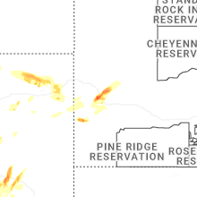
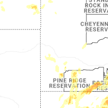


Connect with Interactive Hail Maps