

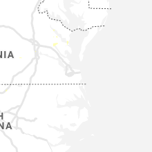
Hail Map for Friday, July 17, 2020

Number of Impacted Households on 7/17/2020
0
Impacted by 1" or Larger Hail
0
Impacted by 1.75" or Larger Hail
0
Impacted by 2.5" or Larger Hail
Square Miles of Populated Area Impacted on 7/17/2020
0
Impacted by 1" or Larger Hail
0
Impacted by 1.75" or Larger Hail
0
Impacted by 2.5" or Larger Hail


Cities Most Affected by Hail Storms of 7/17/2020
| Hail Size | Demographics of Zip Codes Affected | ||||||
|---|---|---|---|---|---|---|---|
| City | Count | Average | Largest | Pop Density | House Value | Income | Age |
| Minot, ND | 3 | 1.83 | 2.00 | 122 | $80k | $36.5k | 32.4 |
| Sheyenne, ND | 1 | 2.75 | 2.75 | 2 | $25k | $24.6k | 45.2 |
| Tokio, ND | 1 | 2.75 | 2.75 | 0 | $10k | $19.1k | 23.5 |
| Springfield, SD | 1 | 2.00 | 2.00 | 7 | $61k | $32.9k | 38.8 |
| Velva, ND | 1 | 2.00 | 2.00 | 5 | $54k | $31.7k | 42.2 |
| Baldwin, ND | 1 | 2.00 | 2.00 | 4 | $74k | $45.2k | 44.2 |
| Ruso, ND | 1 | 1.75 | 1.75 | 1 | $48k | $28.1k | 51.5 |
| Granville, ND | 1 | 1.75 | 1.75 | 3 | $35k | $27.0k | 44.7 |
Hail and Wind Damage Spotted on 7/17/2020
Filter by Report Type:Hail ReportsWind Reports
States Impacted
South Dakota, Nebraska, Virginia, Florida, North Dakota, North Carolina, Illinois, Minnesota, New Mexico, WisconsinSouth Dakota
| Local Time | Report Details |
|---|---|
| 8:26 AM CDT | Several tree branches down... some around 3 to 4 inches in diameter. nickel size hail also observe in bon homme county SD, 46.8 miles NE of Oneill, NE |
| 8:29 AM CDT | Half Dollar sized hail reported near Springfield, SD, 47.6 miles NE of Oneill, NE |
| 8:29 AM CDT | Hen Egg sized hail reported near Springfield, SD, 47.2 miles NE of Oneill, NE, hail slightly larger than 2 inches in diameter. picture relayed via social media. |
| 9:20 AM CDT | Quarter sized hail reported near Emery, SD, 46.7 miles W of Sioux Falls, SD, a few hail stones as large as 1 inch in diameter. |
| 11:00 PM CDT | Storm damage reported in marshall county SD, 55.3 miles ENE of Aberdeen, SD |
| 11:15 PM CDT | Many trees down and power ou in roberts county SD, 71.8 miles SSW of Fargo, ND |
| 11:17 PM CDT | Storm damage reported in roberts county SD, 74.4 miles ENE of Aberdeen, SD |
| 11:25 PM CDT | Trees dow in roberts county SD, 70.5 miles S of Fargo, ND |
| 11:35 PM CDT | Trees down and power out in parts of tow in roberts county SD, 71.1 miles ENE of Aberdeen, SD |
| 11:38 PM CDT | Storm damage reported in roberts county SD, 71.8 miles WNW of Montevideo, MN |
| 11:40 PM CDT | Trees dow in roberts county SD, 73 miles NW of Montevideo, MN |
| 11:51 PM CDT | Storm damage reported in roberts county SD, 70.1 miles WNW of Montevideo, MN |
| 1:40 AM CDT | Tent blown over with estimated 50 to 60 mph wind in brookings county SD, 70.8 miles NNW of Sioux Falls, SD |
Nebraska
| Local Time | Report Details |
|---|---|
| 8:46 AM CDT | Ping Pong Ball sized hail reported near Niobrara, NE, 48.5 miles ENE of Oneill, NE, quarter size hail at the santee tribe museum but another report in town said hail was just a little smaller than golfball size. |
Virginia
| Local Time | Report Details |
|---|---|
| 1:41 PM EDT | Tree down on doss r in campbell county VA, 52.2 miles E of Roanoke, VA |
| 2:27 PM EDT | Tree down on power lin in campbell county VA, 45.8 miles E of Roanoke, VA |
| 3:04 PM EDT | Tree down blocking roa in bedford county VA, 31.5 miles ESE of Roanoke, VA |
| 4:19 PM EDT | Nws employee reports numerous trees down along route 10 near thomas dale high schoo in chesterfield county VA, 15.3 miles SE of Richmond, VA |
| 4:48 PM EDT | Tree dow in pittsylvania county VA, 39.3 miles SE of Roanoke, VA |
| 5:05 PM EDT | Tree dow in henry county VA, 41.5 miles S of Roanoke, VA |
| 5:15 PM EDT | 2 trees dow in halifax county VA, 62.3 miles NNW of Raleigh, NC |
Florida
| Local Time | Report Details |
|---|---|
| 2:20 PM EDT | A tree was reported down along diana avenue in fort myers. time estimated from rada in lee county FL, 35.2 miles N of Naples, FL |
North Dakota
| Local Time | Report Details |
|---|---|
| 1:49 PM CDT | Rolette county emergency manager reported winds up to 60 mph. time estimated from rada in rolette county ND, 59 miles NW of Devils Lake, ND |
| 1:56 PM CDT | Quarter sized hail reported near Rolette, ND, 59 miles NW of Devils Lake, ND, relayed through social media. time estimated from radar. |
| 2:00 PM CDT | Quarter sized hail reported near Rolette, ND, 59 miles NW of Devils Lake, ND |
| 2:07 PM CDT | Golf Ball sized hail reported near Minot, ND, 0.3 miles NW of Minot, ND, hail reported from two different sources between 1.0 inch and 1.75 inches. |
| 2:09 PM CDT | Golf Ball sized hail reported near Minot, ND, 4.9 miles E of Minot, ND, arb observer. |
| 2:21 PM CDT | Awos station krug rugby airport. time estimated from rada in pierce county ND, 56.8 miles WNW of Devils Lake, ND |
| 2:25 PM CDT | Quarter sized hail reported near Minot, ND, 9.9 miles N of Minot, ND |
| 2:25 PM CDT | Hen Egg sized hail reported near Minot, ND, 3 miles N of Minot, ND, lots of 1 inch to golfball size hail. a few hen egg size. hail was found in field by spotters after the storm ended. time estimated by radar. |
| 2:42 PM CDT | Storm damage reported in walsh county ND, 70.5 miles E of Devils Lake, ND |
| 3:35 PM CDT | Peak winds measured at an ndawn statio in benson county ND, 21.9 miles WNW of Devils Lake, ND |
| 3:35 PM CDT | Several 12 inch diameter or larger tree branches and limbs broken down in shelter belt. also dime to nickel sized hai in benson county ND, 45.4 miles W of Devils Lake, ND |
| 3:39 PM CDT | Peak winds measured at an ndawn statio in benson county ND, 21.9 miles WNW of Devils Lake, ND |
| 3:46 PM CDT | Peak wind measured at an rwis station along highway in benson county ND, 22.7 miles WNW of Devils Lake, ND |
| 3:48 PM CDT | Storm damage reported in pierce county ND, 49.7 miles ENE of Minot, ND |
| 3:52 PM CDT | Peak winds measured at an ndawn statio in walsh county ND, 44.7 miles NE of Devils Lake, ND |
| 4:00 PM CDT | Storm damage reported in pierce county ND, 53.1 miles ENE of Minot, ND |
| 4:01 PM CDT | Secondary peak winds at an rwis station along highway in benson county ND, 22.7 miles WNW of Devils Lake, ND |
| 4:32 PM CDT | Metal roofing and siding blown off a building. time estimated based on radar. photo and report posted via socila medi in walsh county ND, 70.5 miles ENE of Devils Lake, ND |
| 4:41 PM CDT | Several large branches dow in grand forks county ND, 77.7 miles E of Devils Lake, ND |
| 4:42 PM CDT | Storm damage reported in walsh county ND, 70.5 miles E of Devils Lake, ND |
| 4:45 PM CDT | A tree snapped in half. photo and report posted via social medi in grand forks county ND, 64.8 miles ESE of Devils Lake, ND |
| 4:46 PM CDT | Peak wind measured at an rwis station along highway in benson county ND, 22.7 miles WNW of Devils Lake, ND |
| 4:51 PM CDT | Peak winds measured at the grand forks airport /kgfk in grand forks county ND, 74.7 miles NNW of Fargo, ND |
| 4:53 PM CDT | Gusts estimated from 60 to 65 mp in grand forks county ND, 76.4 miles N of Fargo, ND |
| 4:55 PM CDT | Trees blown down. time estimated based on rada in steele county ND, 63.2 miles NW of Fargo, ND |
| 4:56 PM CDT | Peak wind measured at the grand forks airport /kgfk in grand forks county ND, 76.6 miles NNW of Fargo, ND |
| 5:00 PM CDT | Golf Ball sized hail reported near Granville, ND, 20.4 miles ESE of Minot, ND |
| 5:01 PM CDT | Peak wnd measured at an rwis statio in grand forks county ND, 76.4 miles N of Fargo, ND |
| 5:04 PM CDT | Baseball sized hail reported near Tokio, ND, 13.4 miles S of Devils Lake, ND, photo and report posted via social media. |
| 5:10 PM CDT | Baseball sized hail reported near Sheyenne, ND, 19.6 miles S of Devils Lake, ND, golfball to baseball sized hail. |
| 5:17 PM CDT | A light pole was blwn down near the post office. several large branches broken down as wel in grand forks county ND, 72 miles N of Fargo, ND |
| 5:20 PM CDT | Ping Pong Ball sized hail reported near Devils Lake, ND, 5.4 miles WSW of Devils Lake, ND, hail near woodland resort. photo an dreport posted via social media. |
| 5:31 PM CDT | Golf Ball sized hail reported near Ruso, ND, 32.8 miles SSE of Minot, ND, golf ball hail lasted five minutes. |
| 5:37 PM CDT | Hen Egg sized hail reported near Velva, ND, 18.3 miles ESE of Minot, ND |
| 5:48 PM CDT | Ping Pong Ball sized hail reported near Anamoose, ND, 54.8 miles ESE of Minot, ND, relayed through broadcast media. time estimated from radar. |
| 6:10 PM CDT | Road sign blown down. report posted vai social media. time estimated based on rada in cass county ND, 28.5 miles NW of Fargo, ND |
| 6:10 PM CDT | Road sign blown down. report posted vai social media. time estimated based on rada in cass county ND, 28.5 miles NW of Fargo, ND |
| 6:30 PM CDT | Quarter sized hail reported near Mandan, ND, 4.6 miles WNW of Bismarck, ND |
| 6:40 PM CDT | Quarter sized hail reported near Bismarck, ND, 3.2 miles NNW of Bismarck, ND |
| 6:54 PM CDT | Tree blown down. time estimated based on rada in cass county ND, 17.8 miles SW of Fargo, ND |
| 6:55 PM CDT | Hen Egg sized hail reported near Baldwin, ND, 15.6 miles NNW of Bismarck, ND, 3 n double ditch. relayed through broadcast media. delayed report. time estimated from radar. |
| 7:15 PM CDT | Ping Pong Ball sized hail reported near Baldwin, ND, 15.6 miles N of Bismarck, ND, lasted about 15 minutes. |
| 7:42 PM CDT | Quarter sized hail reported near Woodworth, ND, 62.1 miles SSW of Devils Lake, ND |
| 9:15 PM CDT | Started getting peas size hail and heavy rain at the time of the cal in stutsman county ND, 85.8 miles N of Aberdeen, SD |
| 9:40 PM CDT | Storm total report from earlier this evening. 2.80 inches of heavy rain and gusty wind in stutsman county ND, 62.3 miles SSW of Devils Lake, ND |
North Carolina
| Local Time | Report Details |
|---|---|
| 3:25 PM EDT | One tree needed to be removed from the roadway very near edneyville. also had some pea sized hai in henderson county NC, 41.1 miles NNE of Greenville, SC |
| 4:03 PM EDT | Trees down off whitaker rd just nne of fairvie in union county NC, 18.1 miles ESE of Charlotte, NC |
| 5:10 PM EDT | Tree down on a car near short street and lang stree in alamance county NC, 45.9 miles WNW of Raleigh, NC |
| 5:10 PM EDT | Tree down on a car near short street and lang stree in alamance county NC, 45.9 miles WNW of Raleigh, NC |
| 5:16 PM EDT | Trees down off amity hill rd... se of statesvill in iredell county NC, 35.7 miles N of Charlotte, NC |
| 5:56 PM EDT | Trees blown down just off glory rd and charlotte hw in iredell county NC, 25.4 miles N of Charlotte, NC |
| 5:57 PM EDT | 2 trees dow in caswell county NC, 62.2 miles SSE of Roanoke, VA |
| 6:05 PM EDT | Tree down across the road near baltimore road and ferguson c in warren county NC, 49.7 miles NE of Raleigh, NC |
| 6:05 PM EDT | Tree down near the intersection of tower road and cool springs roa in warren county NC, 44.4 miles NNE of Raleigh, NC |
| 6:32 PM EDT | Trees down off brantley rd and china grove r in cabarrus county NC, 23 miles NNE of Charlotte, NC |
| 7:05 PM EDT | Trees down off crescent rd... nw of rockwel in rowan county NC, 33.2 miles NE of Charlotte, NC |
Illinois
| Local Time | Report Details |
|---|---|
| 4:09 PM CDT | Asos station kmdh carbondale i in jackson county IL, 36.7 miles NNE of Cape Girardeau, MO |
| 4:30 PM CDT | Numerous trees down in the hickory ridge area near pomon in jackson county IL, 25.7 miles NNE of Cape Girardeau, MO |
Minnesota
| Local Time | Report Details |
|---|---|
| 4:49 PM CDT | Peak winds measured at a personal weather statio in marshall county MN, 66 miles WSW of Roseau, MN |
| 5:05 PM CDT | Numerous large branches and limbs broken down around town. a large old tree snapped. photos and reports posted via social media in polk county MN, 73.7 miles N of Fargo, ND |
| 5:06 PM CDT | Bleachers at the football field were rolled and destroyed. a grain bin was dented in. photo and report posted via social media. time estimated based on rada in marshall county MN, 59.5 miles SW of Roseau, MN |
| 5:06 PM CDT | Bleachers at the football field were rolled and destroyed. photo and report posted via social media. time estimated based on rada in marshall county MN, 57.7 miles WSW of Roseau, MN |
| 5:45 PM CDT | Peak wind measured with a personal weather statio in marshall county MN, 41.1 miles SSW of Roseau, MN |
| 5:45 PM CDT | Tree damage in town from 545 through 550 pm cd in polk county MN, 61 miles WNW of Bemidji, MN |
| 5:46 PM CDT | Trees uprooted on northwest side of town. reports and photos posted via social medi in pennington county MN, 53.7 miles SSW of Roseau, MN |
| 5:49 PM CDT | Peak wind measured at the thief river falls airport /ktvf in pennington county MN, 55.6 miles SSW of Roseau, MN |
| 6:20 PM CDT | Trees blwon down in a shelterbelt. photo and report posted via social medi in norman county MN, 23.8 miles N of Fargo, ND |
| 6:37 PM CDT | Small tree blown down in town. photo and report posted via social media. time estimated based on rada in clearwater county MN, 29.8 miles WNW of Bemidji, MN |
| 7:03 PM CDT | Numerous large branches and limbs broken down. report posted via social media. time estimated based on rada in clearwater county MN, 17.6 miles WSW of Bemidji, MN |
| 7:10 PM CDT | Several trees blown dow in beltrami county MN, 5.2 miles W of Bemidji, MN |
| 7:15 PM CDT | Large mature trees snapped and blocking road. time estimated based on rada in beltrami county MN, 9.5 miles W of Bemidji, MN |
| 7:35 PM CDT | Branches and power lines down near the universit in beltrami county MN, 0.5 miles N of Bemidji, MN |
| 7:50 PM CDT | Large tree snapped. time estimated based on rada in becker county MN, 32.3 miles E of Fargo, ND |
| 8:20 PM CDT | Trees down on highway 3 in becker county MN, 44.7 miles SSW of Bemidji, MN |
| 8:30 PM CDT | Wind damage to porch. estimated winds of 70 to 80 mp in wadena county MN, 51 miles SSW of Bemidji, MN |
| 8:39 PM CDT | Peak wind measured at the park rapids airport /kpkd in hubbard county MN, 41.4 miles SSW of Bemidji, MN |
| 8:40 PM CDT | Estimated wind gust of 50-60 mph from a report sent in via social medi in cass county MN, 37.5 miles SE of Bemidji, MN |
| 8:40 PM CDT | Quarter sized hail reported near Park Rapids, MN, 32.4 miles SSW of Bemidji, MN |
| 8:45 PM CDT | Storm damage reported in wadena county MN, 59.1 miles S of Bemidji, MN |
| 8:52 PM CDT | Power lines down per county dispatc in cass county MN, 41.2 miles SSE of Bemidji, MN |
| 9:43 PM CDT | Branches of 1.5-2 inches in diameter were coming dow in cass county MN, 61.7 miles SSE of Bemidji, MN |
| 9:44 PM CDT | Quarter sized hail reported near Verndale, MN, 74.4 miles S of Bemidji, MN, report from social media. |
| 9:55 PM CDT | Personal weather station on upper trelipe lak in cass county MN, 52.5 miles SE of Bemidji, MN |
| 10:00 PM CDT | 911 dispatch reports multiple trees down across central parts of the count in cass county MN, 49.4 miles SSE of Bemidji, MN |
| 10:08 PM CDT | Trees beginning to be reported going down and taking out power line in todd county MN, 76.3 miles S of Bemidji, MN |
| 10:30 PM CDT | Storm damage reported in traverse county MN, 64 miles NNW of Montevideo, MN |
| 11:20 PM CDT | 10 inch diameter tree down at county road 24 and 157th av in todd county MN, 83.5 miles S of Bemidji, MN |
| 11:35 PM CDT | Tree down across highwa in stevens county MN, 46.4 miles N of Montevideo, MN |
| 11:35 PM CDT | Numerous 3 and 4 inch branches dow in pope county MN, 47 miles N of Montevideo, MN |
| 12:25 AM CDT | Mndot rwis along highway 21 in lac qui parle county MN, 34.5 miles W of Montevideo, MN |
| 12:41 AM CDT | Mesonet station ew9116 foresto in mille lacs county MN, 58.1 miles NNW of Minneapolis, MN |
| 12:45 AM CDT | Farm equipment thrown around. several 800 pound bales of hay blown aroun in mille lacs county MN, 55.8 miles NNW of Minneapolis, MN |
| 1:15 AM CDT | Several trees down in dalb in isanti county MN, 47.5 miles N of Minneapolis, MN |
| 1:15 AM CDT | At least one dozen trees down and power out in stanchfield per law enforcement and social medi in isanti county MN, 47.9 miles N of Minneapolis, MN |
| 1:25 AM CDT | Deputy saw several trees go down in rush city along highway 6 in chisago county MN, 51.2 miles NNE of Minneapolis, MN |
| 1:35 AM CDT | 11 inch diameter tree limb fell on car causing damag in lyon county MN, 34.8 miles S of Montevideo, MN |
| 2:28 AM CDT | Power pole down on cr-2 in gibbon. time estimated from rada in sibley county MN, 65.3 miles ESE of Montevideo, MN |
| 3:04 AM CDT | Storm damage reported in hennepin county MN, 14.4 miles SW of Minneapolis, MN |
New Mexico
| Local Time | Report Details |
|---|---|
| 5:46 PM MDT | Kcqc aso in torrance county NM, 56.4 miles E of Albuquerque, NM |
| 5:53 PM MDT | Kcqc aso in torrance county NM, 56.4 miles E of Albuquerque, NM |
Wisconsin
| Local Time | Report Details |
|---|---|
| 1:48 AM CDT | Photo on social media of trees and power pole guy wires down at county road o and lindgren road. possible tornado damage. time estimated from rada in douglas county WI, 24.2 miles ESE of Duluth, MN |
| 2:51 AM CDT | Time estimated from radar. anemometer mounted 10 ft above ground leve in bayfield county WI, 60.5 miles ESE of Duluth, MN |
| 2:51 AM CDT | Time estimated from radar. anemometer mounted 10 ft above ground leve in bayfield county WI, 60.5 miles ESE of Duluth, MN |
| 5:16 AM CDT | Trees reported down. relayed via law enforcement in oneida county WI, 11.2 miles NNE of Rhinelander, WI |
| 5:16 AM CDT | Tree down. relayed via law enforcement in oneida county WI, 16 miles NE of Rhinelander, WI |
| 5:23 AM CDT | Trees down. relayed via law enforcemen in oneida county WI, 16 miles NE of Rhinelander, WI |
| 5:37 AM CDT | Bank sign and traffic lights down in westo in marathon county WI, 51.6 miles S of Rhinelander, WI |
| 5:39 AM CDT | Numerous trees down on residences... powerlines damaged. officer reported it was worst between county rd x and oak rd along 153 near central wisconsin airpor in marathon county WI, 59.6 miles S of Rhinelander, WI |
| 5:40 AM CDT | Trees and wires down across two intersection in marathon county WI, 48 miles SSW of Rhinelander, WI |
Connect with Interactive Hail Maps