

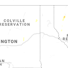
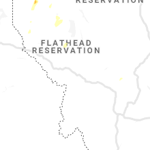
Hail Map for Tuesday, July 23, 2019

Number of Impacted Households on 7/23/2019
0
Impacted by 1" or Larger Hail
0
Impacted by 1.75" or Larger Hail
0
Impacted by 2.5" or Larger Hail
Square Miles of Populated Area Impacted on 7/23/2019
0
Impacted by 1" or Larger Hail
0
Impacted by 1.75" or Larger Hail
0
Impacted by 2.5" or Larger Hail


Cities Most Affected by Hail Storms of 7/23/2019
| Hail Size | Demographics of Zip Codes Affected | ||||||
|---|---|---|---|---|---|---|---|
| City | Count | Average | Largest | Pop Density | House Value | Income | Age |
| Hill City, SD | 1 | 1.75 | 1.75 | 3 | $97k | $36.2k | 47.3 |
Hail and Wind Damage Spotted on 7/23/2019
Filter by Report Type:Hail ReportsWind Reports
States Impacted
North Carolina, Massachusetts, Virginia, South Dakota, South Carolina, Wyoming, Colorado, California, Washington, Idaho, MontanaNorth Carolina
| Local Time | Report Details |
|---|---|
| 9:26 AM EDT | Tree blown down at intersection of johnson road and robertson ridge road. time estimated from rada in stokes county NC, 67.9 miles SSW of Roanoke, VA |
| 12:08 PM EDT | Two trees down at boones cave rd and old pasture r in davidson county NC, 44.2 miles NNE of Charlotte, NC |
| 12:29 PM EDT | Tree down at nc highway 8 and jersey church r in davidson county NC, 48.3 miles NE of Charlotte, NC |
| 12:46 PM EDT | Tree down on hogan bowers r in davidson county NC, 59 miles NE of Charlotte, NC |
| 12:54 PM EDT | Debris in road and tree limbs down at lawndale dr and wingate st in greensbor in guilford county NC, 69.7 miles WNW of Raleigh, NC |
| 12:54 PM EDT | Tree down at burnetts chapel rd and drake r in guilford county NC, 68.7 miles W of Raleigh, NC |
| 1:04 PM EDT | Tree down at s main st extension and mt vista health park r in davidson county NC, 48.9 miles NE of Charlotte, NC |
| 1:38 PM EDT | Large limbs and one tree down in high win in currituck county NC, 17.5 miles SSW of Virginia Beach, VA |
| 1:56 PM EDT | Tree down at 556 s carbonton r in moore county NC, 44.9 miles WSW of Raleigh, NC |
| 2:00 PM EDT | Tree down on badders r in lee county NC, 32.1 miles WSW of Raleigh, NC |
| 2:05 PM EDT | Correction: tree down on lower moncure rd near the deep rive in lee county NC, 27.6 miles WSW of Raleigh, NC |
| 2:05 PM EDT | Several trees down on hwy in lee county NC, 30.9 miles WSW of Raleigh, NC |
| 2:19 PM EDT | Tree down at nc highway 211 and love grove church r in moore county NC, 64.1 miles SW of Raleigh, NC |
| 2:27 PM EDT | Downed tree on power lines at highway 55 near w holly springs rd. a power outage resulted... affecting traffic signal in wake county NC, 14.5 miles SW of Raleigh, NC |
| 2:35 PM EDT | Storm damage on spruce meadows ln in willow springs. possible tornad in wake county NC, 14.5 miles SSW of Raleigh, NC |
| 2:35 PM EDT | 6 - 7 trees down... 3 - 4 poles down causing power outage in wake county NC, 14 miles SSW of Raleigh, NC |
| 2:36 PM EDT | 10 - 12 trees down or... blown apar in wake county NC, 14.2 miles SSW of Raleigh, NC |
| 2:45 PM EDT | Corrects previous tstm wnd dmg report from 3 ene moyock. trees downed and partially blocking road along tulls creek rd. numerous power outages reported in the are in currituck county NC, 17.7 miles S of Virginia Beach, VA |
| 2:53 PM EDT | Tree down at summer hill church rd and murdocksville r in moore county NC, 56.1 miles SW of Raleigh, NC |
| 3:26 PM EDT | Trees and power lines dow in perquimans county NC, 45.2 miles SSW of Virginia Beach, VA |
| 3:34 PM EDT | Tree down at saint marys church rd and mobley r in wilson county NC, 34.8 miles ESE of Raleigh, NC |
| 3:45 PM EDT | Trees downed and partially blocking road along tulls creek rd. numerous power outages reported in the are in currituck county NC, 17.7 miles S of Virginia Beach, VA |
| 4:00 PM EDT | Multiple trees downed along s trotman road... just north of shiloh. time is radar estimate in camden county NC, 31.4 miles S of Virginia Beach, VA |
| 4:03 PM EDT | Tree down on power line at 7024 church st in saratog in wilson county NC, 49.8 miles E of Raleigh, NC |
| 5:20 PM EDT | Tree downed near the camden county library along run swamp r in camden county NC, 27.7 miles S of Virginia Beach, VA |
| 5:50 PM EDT | Trees down at forest dr and richardson r in bladen county NC, 54.7 miles WNW of Wilmington, NC |
Massachusetts
| Local Time | Report Details |
|---|---|
| 11:34 AM EDT | Storm damage reported in dukes county MA, 49.4 miles ESE of Providence, RI |
| 11:38 AM EDT | Popponesset in barnstable county MA, 49.6 miles ESE of Providence, RI |
| 11:40 AM EDT | Multiple trees down across tow in barnstable county MA, 49.6 miles ESE of Providence, RI |
| 11:48 AM EDT | Tree down on wires on barnstable road. large branch down in front of the simmons homestead on pitchers way blocking one lane. wires down on scudder avenue. tree down bl in barnstable county MA, 58.1 miles E of Providence, RI |
| 11:59 AM EDT | Storm damage reported in barnstable county MA, 60 miles ESE of Providence, RI |
| 12:00 PM EDT | Roof blown off a section of cape sands in in barnstable county MA, 61.8 miles E of Providence, RI |
| 12:01 PM EDT | Tree down on gosnold street at old colony roa in barnstable county MA, 58.7 miles ESE of Providence, RI |
| 12:04 PM EDT | Tree down on a car. wires dow in barnstable county MA, 61.6 miles E of Providence, RI |
| 12:04 PM EDT | Storm damage reported in barnstable county MA, 61.4 miles E of Providence, RI |
| 12:05 PM EDT | Tree down on wires on scudder road. several large trees and many large branches down on wianno avenue. 2 small boats flipped over in west ba in barnstable county MA, 54.5 miles ESE of Providence, RI |
| 12:06 PM EDT | Multiple trees down on long pond roa in barnstable county MA, 62.9 miles E of Providence, RI |
| 12:08 PM EDT | Storm damage reported in barnstable county MA, 65.3 miles E of Providence, RI |
| 12:10 PM EDT | Tree and wires down on route 28 at pond street... route 28 at geneva street... sharon way... uncle ephriams way... pine street... highland avenue... kelly road and star in barnstable county MA, 61.6 miles E of Providence, RI |
| 12:14 PM EDT | Large tree down blocking stony brook road. tree and power lines down on run hill roa in barnstable county MA, 69 miles E of Providence, RI |
| 12:15 PM EDT | Trees... utility poles and wires down on south street at sisson road. wires down on route 137 at route 39. tree down on route 3 in barnstable county MA, 70 miles E of Providence, RI |
| 12:15 PM EDT | Storm damage reported in barnstable county MA, 74.9 miles E of Providence, RI |
| 12:19 PM EDT | Storm damage reported in barnstable county MA, 74.9 miles E of Providence, RI |
| 12:20 PM EDT | 2 utility poles leaning on morris island causeway with 1 snapped in half and wires hanging low to the groun in barnstable county MA, 75.7 miles E of Providence, RI |
| 12:24 PM EDT | Several dozen trees down on route 2 in barnstable county MA, 70 miles E of Providence, RI |
| 12:30 PM EDT | Multiple trees dow in barnstable county MA, 75.7 miles E of Providence, RI |
| 12:30 PM EDT | Trees down with one blocking route 28 southbound. wires down on main street. large tree down on quanset road by ridgewood motel. wires down on karen lane. tree down on in barnstable county MA, 72.9 miles E of Providence, RI |
Virginia
| Local Time | Report Details |
|---|---|
| 1:20 PM EDT | Tree downed along benefit road at st brides r in city of chesapeake county VA, 13.2 miles SW of Virginia Beach, VA |
South Dakota
| Local Time | Report Details |
|---|---|
| 4:00 PM MDT | Golf Ball sized hail reported near Hill City, SD, 28.4 miles W of Rapid City, SD |
| 4:41 PM MDT | Ping Pong Ball sized hail reported near Hill City, SD, 25.9 miles W of Rapid City, SD |
| 4:48 PM MDT | Ping Pong Ball sized hail reported near Hill City, SD, 25.9 miles W of Rapid City, SD |
| 4:59 PM MDT | Ping Pong Ball sized hail reported near Hill City, SD, 25.9 miles W of Rapid City, SD |
South Carolina
| Local Time | Report Details |
|---|---|
| 6:15 PM EDT | Tree down at intersection of round o rd and dodds farm ln per sc highway patrol. time estimated based on report time and rada in colleton county SC, 35.4 miles SW of Charleston, SC |
Wyoming
| Local Time | Report Details |
|---|---|
| 4:41 PM MDT | Ping Pong Ball sized hail reported near Newcastle, WY, 56.2 miles SSE of Gillette, WY |
| 4:48 PM MDT | Ping Pong Ball sized hail reported near Newcastle, WY, 56.2 miles SSE of Gillette, WY |
Colorado
| Local Time | Report Details |
|---|---|
| 5:55 PM MDT | Quarter sized hail reported near Divide, CO, 55.3 miles NNW of Pueblo, CO |
California
| Local Time | Report Details |
|---|---|
| 5:08 PM PDT | Power pole dow in riverside county CA, 40.9 miles SSE of Yucca Valley, CA |
| 5:09 PM PDT | Power pole leaning across roadwa in riverside county CA, 42.3 miles SSE of Yucca Valley, CA |
| 5:13 PM PDT | Power pole down... blocking roadwa in riverside county CA, 39.1 miles SSE of Yucca Valley, CA |
| 5:21 PM PDT | Tree in roadwa in riverside county CA, 37.8 miles SSE of Yucca Valley, CA |
| 5:24 PM PDT | Tree fell on top of vehicle. man was inside the vehicle and is now pinned inside the vehicl in riverside county CA, 43.2 miles SSE of Yucca Valley, CA |
| 5:27 PM PDT | Power pole dow in riverside county CA, 43 miles SSE of Yucca Valley, CA |
| 5:29 PM PDT | Large tree branch blocking the road at 60th avenue and van buren stree in riverside county CA, 37.7 miles SSE of Yucca Valley, CA |
| 5:33 PM PDT | Power pole dow in riverside county CA, 43 miles SSE of Yucca Valley, CA |
Washington
| Local Time | Report Details |
|---|---|
| 8:59 PM PDT | Corrects previous tstm wnd gst report from spokane internationa in spokane county WA, 6.1 miles WSW of Spokane, WA |
| 8:59 PM PDT | Storm damage reported in spokane county WA, 6.1 miles WSW of Spokane, WA |
| 9:21 PM PDT | Spokane felts field peak wind gus in spokane county WA, 4.9 miles ENE of Spokane, WA |
| 9:42 PM PDT | Reported power outage in his are in spokane county WA, 16.5 miles NNW of Spokane, WA |
| 9:55 PM PDT | Tree downed by wind and lightnin in spokane county WA, 1.4 miles WSW of Spokane, WA |
| 10:10 PM PDT | Tree downed and damaged vehicle in spokane county WA, 2.6 miles S of Spokane, WA |
Idaho
| Local Time | Report Details |
|---|---|
| 9:40 PM PDT | Idaho state route 3: road blocked from canary creek road to black rock road due to fallen tree in kootenai county ID, 42.6 miles ESE of Spokane, WA |
Montana
| Local Time | Report Details |
|---|---|
| 12:45 AM MDT | Malta south dot on us 191 at mp 122.5 in phillips county MT, 75.4 miles ESE of Havre, MT |
Connect with Interactive Hail Maps