

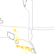
Hail Map for Sunday, July 23, 2023

Number of Impacted Households on 7/23/2023
0
Impacted by 1" or Larger Hail
0
Impacted by 1.75" or Larger Hail
0
Impacted by 2.5" or Larger Hail
Square Miles of Populated Area Impacted on 7/23/2023
0
Impacted by 1" or Larger Hail
0
Impacted by 1.75" or Larger Hail
0
Impacted by 2.5" or Larger Hail

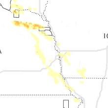


Cities Most Affected by Hail Storms of 7/23/2023
| Hail Size | Demographics of Zip Codes Affected | ||||||
|---|---|---|---|---|---|---|---|
| City | Count | Average | Largest | Pop Density | House Value | Income | Age |
| Chatham, IL | 3 | 2.08 | 2.50 | 361 | $111k | $60.4k | 36.1 |
| Meadville, MO | 1 | 2.50 | 2.50 | 12 | $44k | $34.5k | 41.0 |
| Tyndall, SD | 1 | 1.75 | 1.75 | 8 | $49k | $31.1k | 47.6 |
Hail and Wind Damage Spotted on 7/23/2023
Filter by Report Type:Hail ReportsWind Reports
States Impacted
Florida, Georgia, North Carolina, Michigan, South Carolina, Virginia, Indiana, Illinois, Ohio, Missouri, Utah, Arizona, South Dakota, Texas, West Virginia, Idaho, Nevada, Kansas, NebraskaFlorida
| Local Time | Report Details |
|---|---|
| 10:50 AM EDT | Jefferson co dispatch reports a power line down on old lloyd rd near lloyd creek r in jefferson county FL, 16.4 miles E of Tallahassee, FL |
| 11:47 AM EDT | Madison county dispatch reports a tree and power lines down on ne persimmon dr in pinett in madison county FL, 56.1 miles ENE of Tallahassee, FL |
| 11:50 AM EDT | Tree down caused by tstm wind in hamilton county FL, 69.7 miles S of Douglas, GA |
| 11:55 AM EDT | Tree down caused by thunderstrorm wind in hamilton county FL, 62.1 miles ENE of Tallahassee, FL |
| 12:00 PM EDT | Fallen trees or limbs resulted in a power outage along foley cut-off roa in taylor county FL, 50.7 miles ESE of Tallahassee, FL |
| 1:10 PM EDT | Tree down at the cross section of copper creek drive and n county rd 23a. time estimated using rada in baker county FL, 29 miles W of Jacksonville, FL |
| 1:10 PM EDT | 911 call center reported a tree down near the intersection of hopkins road and smokey road. time estimate based on radar imager in baker county FL, 32.2 miles W of Jacksonville, FL |
| 1:10 PM EDT | 911 call center reported a tree down near the intersection of north county road 23a and north tall pine road. time estimate based on radar imager in baker county FL, 28.9 miles W of Jacksonville, FL |
| 2:20 PM EDT | Oak tree fell onto home in interlachan as a result of strong thunderstorm related wind in putnam county FL, 48.8 miles SSW of Jacksonville, FL |
| 4:07 PM EDT | Public report of limbs and small trees down in palm bay in brevard county FL, 52.5 miles NNW of Port Saint Lucie, FL |
| 5:13 PM EDT | Delayed report: tree damage near paradise park on juanita av in st. lucie county FL, 13.6 miles N of Port Saint Lucie, FL |
| 5:13 PM EDT | Delayed report: tree damage near paradise park on juanita av in st. lucie county FL, 13.6 miles N of Port Saint Lucie, FL |
Georgia
| Local Time | Report Details |
|---|---|
| 12:10 PM EDT | Tree reported down caused by thunderstorm wind in echols county GA, 47.5 miles SSW of Douglas, GA |
| 12:14 PM EDT | Lowndes county dispatch reports a tree on a power line on johnson st in valdost in lowndes county GA, 52.8 miles SSW of Douglas, GA |
| 1:00 PM EDT | Lee county dispatch reported a tree down on leslie hwy near 3rd s in lee county GA, 79.4 miles WNW of Douglas, GA |
North Carolina
| Local Time | Report Details |
|---|---|
| 1:05 PM EDT | Duke energy reports power outage caused by fallen trees and limb in union county NC, 14.2 miles SSE of Charlotte, NC |
| 5:58 PM EDT | Thunderstorm winds blew down one tree along hilltop boulevar in rockingham county NC, 64.5 miles SSE of Roanoke, VA |
| 6:01 PM EDT | Thunderstorm winds blew down one tree that took down power lines as it fell near the intersection of sparta road and longbottom roa in wilkes county NC, 58.1 miles ESE of Bristol, TN |
Michigan
| Local Time | Report Details |
|---|---|
| 1:50 PM EDT | Public report of large tree down near townline rd and lakeview d in oscoda county MI, 42.6 miles WSW of Alpena, MI |
South Carolina
| Local Time | Report Details |
|---|---|
| 2:26 PM EDT | Tweet shows pictures of damage to an aluminum topped garage and to trees in a nearby forest near lynn automotive and center grove baptist church. time estimated by rada in chesterfield county SC, 44.8 miles SE of Charlotte, NC |
| 2:30 PM EDT | Email report received of two very large oaks down... another third large oak snapped and additional damage to other trees on property. picture shows one of the larger d in chesterfield county SC, 46.9 miles SE of Charlotte, NC |
| 2:31 PM EDT | Spotter reports trees down across highway 9 in mount croghan near hough stree in chesterfield county SC, 47.4 miles SE of Charlotte, NC |
| 2:38 PM EDT | Tweet shows several pictures of downed trees near the intersection of hwy 9 and market st. including one showing damage to a structure at this location near the center in chesterfield county SC, 50 miles SE of Charlotte, NC |
| 3:15 PM EDT | Chesterfield co 911 dispatch reported numerous trees down from the ruby and chesterfield area se towards us hwy 1 near the fish hatchery. time estimate in chesterfield county SC, 57 miles SE of Charlotte, NC |
| 4:10 PM EDT | 911 call center reported 4 power poles down in the 2000 block of west frontage road. time estimated from rada in jasper county SC, 31.9 miles NNE of Savannah, GA |
| 6:20 PM EDT | Tempest weather system... id...pee dee rec in darlington county SC, 77 miles NNE of Charleston, SC |
| 7:03 PM EDT | Shutes folly reported a wind gust of 53 knot in amz330 county SC, 30 miles SSE of Charleston, SC |
| 7:16 PM EDT | 911 center reported a tree down at the intersection of hebron and dunbar roa in marlboro county SC, 85.6 miles ESE of Charlotte, NC |
Virginia
| Local Time | Report Details |
|---|---|
| 2:28 PM EDT | Tree dow in patrick county VA, 50.6 miles SSW of Roanoke, VA |
| 2:30 PM EDT | Multiple reports of trees down in stuar in patrick county VA, 47.2 miles SSW of Roanoke, VA |
| 2:35 PM EDT | Trees dow in patrick county VA, 47.4 miles SSW of Roanoke, VA |
| 4:00 PM EDT | Tree dow in henry county VA, 47.2 miles S of Roanoke, VA |
| 4:00 PM EDT | Tree dow in henry county VA, 39.5 miles SSE of Roanoke, VA |
| 4:24 PM EDT | Multiple large limbs downed by thunderstorm winds near the dixon family homeplac in pittsylvania county VA, 48.7 miles SSE of Roanoke, VA |
| 4:49 PM EDT | Tree down on dolly ann driv in alleghany county VA, 40.8 miles N of Roanoke, VA |
| 4:50 PM EDT | Numerous trees downed by thunderstorm winds scattered around southern half of count in pittsylvania county VA, 49 miles SSE of Roanoke, VA |
| 5:15 PM EDT | Tree down across powerlin in city of roanoke county VA, 1.9 miles SE of Roanoke, VA |
| 5:15 PM EDT | Tree and powerline dow in city of roanoke county VA, 1.9 miles ESE of Roanoke, VA |
| 5:16 PM EDT | Powerlines dow in city of roanoke county VA, 1 miles SE of Roanoke, VA |
| 5:19 PM EDT | Tree fell on car. powerline also dow in city of roanoke county VA, 0.6 miles E of Roanoke, VA |
| 5:21 PM EDT | Tree dow in city of roanoke county VA, 1 miles SE of Roanoke, VA |
| 5:40 PM EDT | Thunderstorm winds blew down two trees on walnut avenue near the intersection with third street. hail up to the size of nickels also fell a few minutes earlie in roanoke county VA, 2.3 miles ENE of Roanoke, VA |
| 5:41 PM EDT | Powerlines dow in city of roanoke county VA, 1 miles SSW of Roanoke, VA |
| 5:43 PM EDT | Powerlines down. basement floodin in city of roanoke county VA, 1 miles SE of Roanoke, VA |
| 5:56 PM EDT | Powerlines dow in city of roanoke county VA, 1.3 miles ENE of Roanoke, VA |
| 6:01 PM EDT | Powerlines dow in city of roanoke county VA, 1.9 miles ESE of Roanoke, VA |
| 6:02 PM EDT | Tree dow in city of roanoke county VA, 1 miles SE of Roanoke, VA |
| 6:08 PM EDT | Multiple trees downed in hazelwood... near the intersection of hardy road and beagle club roa in bedford county VA, 5.6 miles E of Roanoke, VA |
| 6:20 PM EDT | Tree down. powerlines dow in bedford county VA, 7.2 miles E of Roanoke, VA |
| 6:27 PM EDT | Tree dow in city of roanoke county VA, 3.9 miles W of Roanoke, VA |
| 7:54 PM EDT | Five trees downed by thunderstorm winds along crocketts cove roa in wythe county VA, 61.3 miles WSW of Roanoke, VA |
| 8:49 PM EDT | Numerous trees downed by thunderstorm winds through eastern part of giles county... many in the staffordsville are in giles county VA, 44.2 miles W of Roanoke, VA |
Indiana
| Local Time | Report Details |
|---|---|
| 3:30 PM EDT | Quarter sized hail reported near Summitville, IN, 47.6 miles NNE of Indianapolis, IN, report from mping: quarter (1.00 in.) time estimated from radar. |
| 3:44 PM EDT | Quarter sized hail reported near Gaston, IN, 49.3 miles NE of Indianapolis, IN, nws employee reported quarter size hail along i-69 near county rd 950n intersection. |
| 4:02 PM EDT | Half Dollar sized hail reported near Muncie, IN, 50.5 miles NE of Indianapolis, IN, public report of 1.25 inch hail nw of muncie. |
| 4:02 PM EDT | Ping Pong Ball sized hail reported near Muncie, IN, 49.4 miles NE of Indianapolis, IN |
| 4:25 PM EDT | Quarter sized hail reported near Selma, IN, 51.9 miles ENE of Indianapolis, IN, public report of hail up to 1.00 inches. |
| 4:26 PM EDT | Quarter sized hail reported near Muncie, IN, 50.2 miles ENE of Indianapolis, IN, public report of 1 inch hail. |
| 4:36 PM EDT | Quarter sized hail reported near Selma, IN, 51.9 miles ENE of Indianapolis, IN, corrects previous hail report from 1 sse prairie creek reservoir. public report of hail up to 1.00 inches. |
| 6:50 PM EDT | Trees blown down on spades roa in ripley county IN, 34.5 miles WNW of Cincinnati, OH |
| 6:58 PM EDT | Damage to a pool and bath house roof. time estimated by rada in ripley county IN, 35.1 miles WNW of Cincinnati, OH |
| 7:22 PM EDT | A tree was downed in sunman. time estimated by rada in ripley county IN, 32.8 miles WNW of Cincinnati, OH |
| 7:55 PM EDT | Several trees down in the milan area... incuding one that fell on a truc in ripley county IN, 33.6 miles W of Cincinnati, OH |
| 8:00 PM EDT | Several trees down in the milan area. time estimated by rada in ripley county IN, 33.6 miles W of Cincinnati, OH |
| 8:02 PM EDT | A tree damaged a house when it fell on it. time estimated by rada in ripley county IN, 33.1 miles W of Cincinnati, OH |
Illinois
| Local Time | Report Details |
|---|---|
| 3:22 PM CDT | Quarter sized hail reported near Hartsburg, IL, 31.6 miles S of Peoria, IL, photo of 1 inch hail relayed via social media. time estimated from radar. |
| 7:05 PM CDT | Quarter sized hail reported near Carlinville, IL, 48.8 miles NNE of Saint Louis, MO, highway 108 and thornbrook rd. time estimated. |
| 7:21 PM CDT | Ping Pong Ball sized hail reported near Loami, IL, 68.2 miles S of Peoria, IL, corrects previous rain report from 3 sw curran. picture of quarter to ping pong ball size hail. relayed via social media. |
| 7:30 PM CDT | Ping Pong Ball sized hail reported near New Berlin, IL, 67.8 miles S of Peoria, IL, photo sent via social media. |
| 7:34 PM CDT | Quarter sized hail reported near Chatham, IL, 70.1 miles S of Peoria, IL |
| 7:37 PM CDT | Quarter sized hail reported near Chatham, IL, 70.8 miles S of Peoria, IL, report from mping: quarter (1.00 in.). |
| 7:38 PM CDT | Hen Egg sized hail reported near Chatham, IL, 70.1 miles S of Peoria, IL, social media photo of 2 inch hail. |
| 7:38 PM CDT | Tennis Ball sized hail reported near Chatham, IL, 70.1 miles S of Peoria, IL, corrects previous hail report from chatham. social media photo of 2.5 inch hail. |
| 7:43 PM CDT | Quarter sized hail reported near Springfield, IL, 68.7 miles S of Peoria, IL, report from mping: quarter (1.00 in.). |
| 7:43 PM CDT | Golf Ball sized hail reported near Chatham, IL, 68.8 miles S of Peoria, IL, photo of golf ball size hail. |
| 7:45 PM CDT | Quarter sized hail reported near Chatham, IL, 70.7 miles S of Peoria, IL, report from mping: quarter (1.00 in.). |
| 7:46 PM CDT | Quarter sized hail reported near Chatham, IL, 68.2 miles WNW of Mattoon, IL, report from mping: quarter (1.00 in.). |
| 7:50 PM CDT | Quarter sized hail reported near Chatham, IL, 70.7 miles S of Peoria, IL, nickel to quarter size hail. |
| 9:17 PM CDT | Half Dollar sized hail reported near Dalton City, IL, 27.6 miles NW of Mattoon, IL, relayed via broadcast media. |
| 4:41 AM CDT | Large tree limb down on a home in christophe in franklin county IL, 53.4 miles NNE of Cape Girardeau, MO |
Ohio
| Local Time | Report Details |
|---|---|
| 4:49 PM EDT | A tree was downed onto the road at the intersection of mccoy road at clairmont roa in franklin county OH, 7.1 miles NW of Columbus, OH |
| 4:52 PM EDT | Asos station kosu columbus ohio state university airpor in franklin county OH, 9.1 miles NNW of Columbus, OH |
| 4:54 PM EDT | Quarter sized hail reported near Columbus, OH, 6.4 miles NNW of Columbus, OH, report from mping: quarter (1.00 in.). |
| 5:08 PM EDT | A pine tree fell into power equipment. time estimated from rada in franklin county OH, 8.3 miles NNE of Columbus, OH |
| 5:15 PM EDT | Multiple trees down in a subdivision near polaris parkway and old state road. one home with some minor siding damage. time estimated from rada in delaware county OH, 13 miles N of Columbus, OH |
| 5:52 PM EDT | Trees and powerlines down across the county. house hit by lightnin in delaware county OH, 14.1 miles NNW of Columbus, OH |
| 5:55 PM EDT | 1 tree down on pleasant valley rd. another large branch down near this locatio in knox county OH, 38 miles NE of Columbus, OH |
| 8:25 PM EDT | Social media picture of a large tree downe in franklin county OH, 11 miles N of Columbus, OH |
| 8:53 PM EDT | Quarter sized hail reported near London, OH, 19 miles W of Columbus, OH |
Missouri
| Local Time | Report Details |
|---|---|
| 4:45 PM CDT | Quarter sized hail reported near Meadville, MO, 74.3 miles NW of Columbia, MO |
| 4:45 PM CDT | Report of a few 6 inch limbs dow in linn county MO, 74.3 miles NW of Columbia, MO |
| 4:50 PM CDT | Tennis Ball sized hail reported near Meadville, MO, 74.3 miles NW of Columbia, MO, follow up from earlier report. caller measured 2.5 inch hail stone in yard. |
Utah
| Local Time | Report Details |
|---|---|
| 4:10 PM MDT | Measured at udot rwis site i-15 at pine creek hill. (utpch in beaver county UT, 29.2 miles WSW of Monroe, UT |
| 5:30 PM MDT | Udot rwis sensor measured wind gust at the dog valley station (utdog in millard county UT, 26.5 miles W of Monroe, UT |
| 6:15 PM MDT | Dugway mesonet station callao gate recorded measurement (dpg02 in tooele county UT, 86.5 miles SW of Salt Lake City, UT |
| 7:05 PM MDT | Measured at the causeway mesonet site on dugway proving ground. site dpg1 in tooele county UT, 94.4 miles NE of Ely, NV |
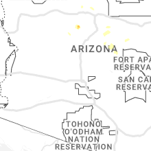
Arizona
| Local Time | Report Details |
|---|---|
| 3:15 PM MST | *corrected* sedona airport awos measured a 52 knot (60 mph) wind gust at 315 arizona time (mst) as thunderstorm outflow moved throug in yavapai county AZ, 25.3 miles SSW of Flagstaff, AZ |
| 3:15 PM MST | *corrected* sedona airport awos measured a 52 knot (60 mph) wind gust at 315 arizona time (mst) as thunderstorm outflow moved throug in yavapai county AZ, 25.3 miles SSW of Flagstaff, AZ |
| 4:49 PM MST | Asos station kols nogales international airpor in santa cruz county AZ, 55.7 miles S of Tucson, AZ |
| 6:15 PM MST | At approximately 6:15 pm pdt... the nevershine raws recorded a thunderstorm wind gust of 61 mph. time estimated using rada in mohave county AZ, 61.6 miles SSW of Saint George, UT |
| 6:45 PM MST | Multiple reports of downed power lines and power poles as well as damage to homes in the area south of ajo and west of i-19. time estimated by rada in pima county AZ, 4 miles SSW of Tucson, AZ |
| 7:17 PM MST | Power pole tilted and irvington road close in pima county AZ, 4.3 miles S of Tucson, AZ |
South Dakota
| Local Time | Report Details |
|---|---|
| 4:37 PM MDT | Storm damage reported in oglala lakota county SD, 66.5 miles SSE of Rapid City, SD |
| 4:47 PM MDT | Storm damage reported in oglala lakota county SD, 63.3 miles SE of Rapid City, SD |
| 5:07 PM MDT | Storm damage reported in oglala lakota county SD, 80.9 miles SSE of Rapid City, SD |
| 2:17 AM CDT | Golf Ball sized hail reported near Tyndall, SD, 56.6 miles NE of Oneill, NE |
Texas
| Local Time | Report Details |
|---|---|
| 6:10 PM CDT | Dispatch reports trees and power lines down in ganado due to thunderstorm wind damag in jackson county TX, 84.8 miles SW of Houston, TX |
| 6:49 PM CDT | Power poles down... no electricit in bee county TX, 47.3 miles NNW of Corpus Christi, TX |
West Virginia
| Local Time | Report Details |
|---|---|
| 7:27 PM EDT | Numerous trees down... and some blocking roads... in the alderson are in greenbrier county WV, 50.2 miles NW of Roanoke, VA |
| 8:21 PM EDT | Thunderstorm winds blew down two trees along the 1000 block of crane roa in greenbrier county WV, 55.5 miles NNW of Roanoke, VA |
Idaho
| Local Time | Report Details |
|---|---|
| 5:58 PM MDT | Tree branch 5in diameter down. station elevation: 4520 f in bannock county ID, 48.5 miles SSW of Idaho Falls, ID |
| 6:07 PM MDT | Large tree branch down in road. blocking south 7th ave at east whitman st. image shared from idaho state journa in bannock county ID, 47.4 miles SSW of Idaho Falls, ID |
| 6:25 PM MDT | Power outages in chubbuck and parts of pocatello from thunderstorm wind in bannock county ID, 45 miles SSW of Idaho Falls, ID |
| 6:36 PM MDT | Asos station kpih pocatello regional airpor in power county ID, 47.6 miles SW of Idaho Falls, ID |
| 6:40 PM MDT | Materials from ongoing construction on knudsen blvd blown into roa in bannock county ID, 45 miles SSW of Idaho Falls, ID |
| 6:50 PM MDT | Tree blown down by thunderstorm winds on fairway driv in bannock county ID, 44.5 miles SSW of Idaho Falls, ID |
Nevada
| Local Time | Report Details |
|---|---|
| 8:11 PM PDT | At 8:11 pm pdt... the sensor at west career and tech academy recorded a thunderstorm wind gust of 58 mph. data courtesy of earth network in clark county NV, 12.3 miles W of Las Vegas, NV |
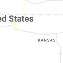
Kansas
| Local Time | Report Details |
|---|---|
| 1:29 AM CDT | Awos station kcbk 2 n colb in thomas county KS, 2.3 miles N of Colby, KS |
Nebraska
| Local Time | Report Details |
|---|---|
| 2:37 AM CDT | Quarter sized hail reported near Mclean, NE, 60.5 miles E of Oneill, NE |
| 3:22 AM CDT | Quarter sized hail reported near Pilger, NE, 78.1 miles NW of Omaha, NE |
| 5:09 AM CDT | Asos station koma omaha eppley airfiel in douglas county NE, 4.6 miles NNE of Omaha, NE |
Connect with Interactive Hail Maps