

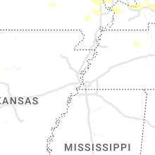
Hail Map for Monday, July 24, 2023

Number of Impacted Households on 7/24/2023
0
Impacted by 1" or Larger Hail
0
Impacted by 1.75" or Larger Hail
0
Impacted by 2.5" or Larger Hail
Square Miles of Populated Area Impacted on 7/24/2023
0
Impacted by 1" or Larger Hail
0
Impacted by 1.75" or Larger Hail
0
Impacted by 2.5" or Larger Hail


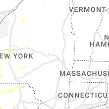


Cities Most Affected by Hail Storms of 7/24/2023
| Hail Size | Demographics of Zip Codes Affected | ||||||
|---|---|---|---|---|---|---|---|
| City | Count | Average | Largest | Pop Density | House Value | Income | Age |
| Hampton, MN | 1 | 1.75 | 1.75 | 49 | $152k | $61.7k | 37.4 |
| Smithland, KY | 1 | 1.75 | 1.75 | 16 | $61k | $31.0k | 44.8 |
| Westerville, OH | 1 | 1.75 | 1.75 | 2348 | $144k | $59.9k | 35.7 |
| Hudson, WI | 1 | 1.75 | 1.75 | 461 | $167k | $67.7k | 37.7 |
Hail and Wind Damage Spotted on 7/24/2023
Filter by Report Type:Hail ReportsWind Reports
States Impacted
Kansas, Missouri, Pennsylvania, New York, Vermont, Massachusetts, West Virginia, Minnesota, Michigan, Kentucky, Wisconsin, Indiana, Florida, Utah, Wyoming, Colorado, Ohio, North Carolina, Montana, Idaho, South Dakota, NebraskaKansas
| Local Time | Report Details |
|---|---|
| 7:06 AM CDT | 10 power poles along k7 north of fairmont rd are either snapped or leanin in leavenworth county KS, 18 miles WNW of Kansas City, MO |
| 7:36 AM CDT | Quarter sized hail reported near Kansas City, KS, 7.4 miles W of Kansas City, MO |
Missouri
| Local Time | Report Details |
|---|---|
| 7:39 AM CDT | Public estimating 70 mph winds in downtown kc. reported via social medi in jackson county MO, 1 miles SSW of Kansas City, MO |
| 7:45 AM CDT | Spotter report of pea sized hail accompanying the win in jackson county MO, 4.5 miles ESE of Kansas City, MO |
| 7:55 AM CDT | Large tree limbs down... power knocked ou in jackson county MO, 9.3 miles ESE of Kansas City, MO |
| 8:14 AM CDT | Winds estimated between 60 and 70 mp in jackson county MO, 19 miles SE of Kansas City, MO |
| 8:14 AM CDT | Quarter sized hail reported near Lees Summit, MO, 14.6 miles SE of Kansas City, MO, via mping. |
| 8:14 AM CDT | Quarter sized hail reported near Lees Summit, MO, 19 miles SE of Kansas City, MO |
| 8:24 AM CDT | Delayed report. large tree snappe in cass county MO, 28.4 miles SE of Kansas City, MO |
| 8:29 AM CDT | Delayed report. large tree limb down. time estimated from rada in jackson county MO, 27.4 miles SE of Kansas City, MO |
| 9:22 AM CDT | Storm damage reported in cass county MO, 44.6 miles SSE of Kansas City, MO |
| 9:25 AM CDT | 60 -70 mph wind estimate in henry county MO, 54.4 miles SE of Kansas City, MO |
| 9:52 AM CDT | Parts city auto. in henry county MO, 66.7 miles SSE of Kansas City, MO |
| 1:34 PM CDT | Asos station kcgi cape girardeau m in scott county MO, 5.4 miles SSW of Cape Girardeau, MO |
| 2:13 PM CDT | Grain silo and metal building blown across highwa in scott county MO, 25.3 miles S of Cape Girardeau, MO |
Pennsylvania
| Local Time | Report Details |
|---|---|
| 11:02 AM EDT | Multiple trees down route 492. time estimated from rada in susquehanna county PA, 29.2 miles N of Scranton, PA |
| 11:02 AM EDT | Trees and wires down route 1039. time estimated from rada in susquehanna county PA, 31.7 miles NNW of Scranton, PA |
| 11:02 AM EDT | Multiple trees and wires down route 547 and route 492. time estimated from rada in susquehanna county PA, 29.7 miles N of Scranton, PA |
| 11:15 AM EDT | Multiple trees down grand street. time estimated from rada in susquehanna county PA, 37.4 miles N of Scranton, PA |
| 11:24 AM EDT | Multiple trees and wires down route 171 and hausbrook heights road. time estimated from rada in susquehanna county PA, 38.7 miles N of Scranton, PA |
| 1:40 PM EDT | Trees and wires down around williamspor in lycoming county PA, 55.9 miles ENE of State College, PA |
| 3:30 PM EDT | Quarter sized hail reported near Watsontown, PA, 56.5 miles ENE of State College, PA |
| 9:20 PM EDT | Tree/wires dow in columbia county PA, 47 miles WSW of Scranton, PA |
| 10:04 PM EDT | Tree down blocking the road. time estimated from rada in susquehanna county PA, 34.7 miles N of Scranton, PA |
| 10:28 PM EDT | Tree down blocking the road. time estimated from rada in susquehanna county PA, 35.6 miles N of Scranton, PA |
| 1:42 AM EDT | 2 ft diameter tree down blocking the roa in dauphin county PA, 63.5 miles SE of State College, PA |
| 1:45 AM EDT | Tree down on the roa in dauphin county PA, 64.4 miles ESE of State College, PA |
New York
| Local Time | Report Details |
|---|---|
| 12:02 PM EDT | Multiple trees down on state route 7 main stree in otsego county NY, 65.5 miles SE of Syracuse, NY |
| 12:55 PM EDT | Trees and wires down at several locations from 12:55 pm to 1:00 p in otsego county NY, 51 miles W of Schenectady, NY |
| 1:15 PM EDT | Half Dollar sized hail reported near Schroon Lake, NY, 52.2 miles SSW of Burlington, VT, hoffman road |
| 1:30 PM EDT | Trees and wires down in multiple locations in the village of herkimer - crossroads of gray and suiter st... margaret st... and shells bush rd (ne of herkimer in herkimer county NY, 55.3 miles WNW of Schenectady, NY |
| 1:30 PM EDT | Downed trees and broken limbs from thunderstorm cell that passed throug in herkimer county NY, 49.4 miles WNW of Schenectady, NY |
| 1:30 PM EDT | Multiple trees and wires down. time estimated from rada in madison county NY, 19.7 miles E of Syracuse, NY |
| 1:35 PM EDT | Trees dow in essex county NY, 44.5 miles SW of Burlington, VT |
| 2:06 PM EDT | Ny 199 closed between w. willets dr and haperman hill rd. downed trees and wire in dutchess county NY, 57.8 miles S of Schenectady, NY |
| 2:10 PM EDT | 15 foot sailboat capsized at red hook dock in dutchess county NY, 56.1 miles S of Schenectady, NY |
| 2:24 PM EDT | Multiple trees trees down on some house in cayuga county NY, 30.8 miles WSW of Syracuse, NY |
| 2:35 PM EDT | Multiple trees uprooted and snapped. wind estimated 55 - 72 mp in essex county NY, 44.8 miles SSW of Burlington, VT |
| 2:35 PM EDT | Multiple trees dow in clinton county NY, 30.2 miles NW of Burlington, VT |
| 2:42 PM EDT | Trees and wires down. time estimated from rada in tompkins county NY, 53.8 miles SSW of Syracuse, NY |
| 2:48 PM EDT | Trees and wires dow in wayne county NY, 47.7 miles W of Syracuse, NY |
| 2:54 PM EDT | Trees and wires dow in wayne county NY, 48 miles WNW of Syracuse, NY |
| 3:00 PM EDT | Trees and wires dow in wayne county NY, 42.7 miles W of Syracuse, NY |
| 3:06 PM EDT | Trees and wires down in the town of clyd in wayne county NY, 36.6 miles W of Syracuse, NY |
| 3:08 PM EDT | Trees and power lines dow in franklin county NY, 50.8 miles W of Burlington, VT |
| 3:23 PM EDT | Trees and wires down in the town of butle in wayne county NY, 32.6 miles WNW of Syracuse, NY |
| 3:24 PM EDT | Storm damage reported in clinton county NY, 24.2 miles NNW of Burlington, VT |
| 3:24 PM EDT | Storm damage reported in clinton county NY, 30.2 miles NW of Burlington, VT |
| 3:29 PM EDT | Tree down on elm street. time estimated from rada in onondaga county NY, 1.1 miles NE of Syracuse, NY |
| 3:38 PM EDT | Trees and wires down at duck lake road and state route 370 near victor in cayuga county NY, 29.6 miles WNW of Syracuse, NY |
| 3:48 PM EDT | Tree down blocking the road. time estimated from rada in tioga county NY, 59.1 miles SSW of Syracuse, NY |
| 3:55 PM EDT | Tree down blocking roa in oswego county NY, 27 miles NW of Syracuse, NY |
| 5:15 PM EDT | Tree downed onto power lines in the town of wiln in jefferson county NY, 48.2 miles S of Ogdensburg, NY |
| 5:20 PM EDT | Multiple trees and wires down in smithfield. time estimated from rada in madison county NY, 24.8 miles ESE of Syracuse, NY |
| 5:31 PM EDT | Barns collapsed with a lot debris... numerous trees down. hayts road and sheffield road in enfield. time estimated from rada in tompkins county NY, 45.4 miles SSW of Syracuse, NY |
| 5:42 PM EDT | Tree down on a house on north aurora s in tompkins county NY, 45.1 miles SSW of Syracuse, NY |
| 5:42 PM EDT | Tree down on twist run road. time estimated from rada in broome county NY, 54.7 miles NNW of Scranton, PA |
| 5:44 PM EDT | Trees and wires down near the corner of bundy rd and trumansburg r in tompkins county NY, 45.1 miles SSW of Syracuse, NY |
| 5:45 PM EDT | Tree down on sally piper road. time estimated from rada in broome county NY, 54.2 miles NNW of Scranton, PA |
| 5:45 PM EDT | Tree down in the town of harrisvill in lewis county NY, 38.5 miles SSE of Ogdensburg, NY |
| 6:02 PM EDT | Tree on a hous in tompkins county NY, 45.1 miles SSW of Syracuse, NY |
| 6:03 PM EDT | Wire on roadwa in tompkins county NY, 48.3 miles SSW of Syracuse, NY |
| 6:16 PM EDT | Tree downed onto the niagara scenic parkway by pletcher roa in niagara county NY, 23.7 miles NNW of Buffalo, NY |
| 6:53 PM EDT | Corrects previous tstm wnd dmg report from 1 wnw west candor. tree down blocking the road. time estimated from rada in tioga county NY, 59.1 miles SSW of Syracuse, NY |
| 7:35 PM EDT | Tree down on brooks road. time estimated from rada in broome county NY, 57.6 miles NNW of Scranton, PA |
Vermont
| Local Time | Report Details |
|---|---|
| 2:25 PM EDT | Trees down on lines on jersey s in addison county VT, 27.4 miles S of Burlington, VT |
Massachusetts
| Local Time | Report Details |
|---|---|
| 2:30 PM EDT | Tree down on pine nook road north of river roa in franklin county MA, 72 miles ESE of Schenectady, NY |
| 7:10 PM EDT | Tree and wires down on a car near elm street and route 11 in essex county MA, 64.5 miles SSW of Portland, ME |
West Virginia
| Local Time | Report Details |
|---|---|
| 2:57 PM EDT | Six trees were reported down in various locations of south central jefferson county in jefferson county WV, 72.5 miles W of Baltimore, MD |
| 4:25 PM EDT | Multiple trees down in downtown huntingto in cabell county WV, 43.2 miles W of Charleston, WV |
| 8:18 PM EDT | Tree down on the 1100 block of circle drive in berkeley county WV, 74.2 miles W of Baltimore, MD |
| 8:18 PM EDT | Powerline pole down on the 400 block of eagle school road in berkeley county WV, 72.9 miles W of Baltimore, MD |
Minnesota
| Local Time | Report Details |
|---|---|
| 2:15 PM CDT | Delayed report - multiple tress and branches down on the southern side of white bear lake. time estimated from rada in ramsey county MN, 13.5 miles ENE of Minneapolis, MN |
| 2:55 PM CDT | Delayed report - multiple trees on powerlines in rosemoun in dakota county MN, 17.8 miles SSE of Minneapolis, MN |
| 3:00 PM CDT | Picture of metal sign bent over. time estimated from rada in dakota county MN, 17.6 miles SSE of Minneapolis, MN |
| 3:00 PM CDT | Quarter sized hail reported near Rosemount, MN, 17.4 miles SSE of Minneapolis, MN, photo relayed via social media. |
| 3:00 PM CDT | Half Dollar sized hail reported near Rosemount, MN, 19.2 miles SSE of Minneapolis, MN, photo via social media. |
| 3:00 PM CDT | 12 to 18 inch trees down... shingles blown off rooftops. delayed report via trained spotter... time estimated by rada in stearns county MN, 73 miles NE of Montevideo, MN |
| 3:02 PM CDT | Ping Pong Ball sized hail reported near Rosemount, MN, 18.6 miles SSE of Minneapolis, MN, photo relayed on social media. |
| 3:03 PM CDT | Delayed report - multiple trees on powerlines in farmingto in dakota county MN, 23.5 miles SSE of Minneapolis, MN |
| 3:11 PM CDT | Golf Ball sized hail reported near Hampton, MN, 28.6 miles SSE of Minneapolis, MN, delayed report - deputy reported golf ball size hail near hampton. time estimated by radar. |
| 3:30 PM CDT | Half Dollar sized hail reported near Dennison, MN, 41.5 miles SSE of Minneapolis, MN, shredded leaves. |
| 3:34 PM CDT | Quarter sized hail reported near Randolph, MN, 33.3 miles SSE of Minneapolis, MN, video relayed via social media. |
| 3:45 PM CDT | Quarter sized hail reported near Clearwater, MN, 49 miles NW of Minneapolis, MN, mostly dime hail with some quarter mixed in. photo relayed via twitter. |
| 4:23 PM CDT | Quarter sized hail reported near Minneapolis, MN, 15.4 miles N of Minneapolis, MN, phone report. |
| 4:45 PM CDT | Half Dollar sized hail reported near West Concord, MN, 57.7 miles SSE of Minneapolis, MN |
Michigan
| Local Time | Report Details |
|---|---|
| 3:21 PM EDT | Delayed reported. several trees down with power outages near moddersville. time estimated via rada in missaukee county MI, 49.4 miles SE of Traverse City, MI |
Kentucky
| Local Time | Report Details |
|---|---|
| 2:35 PM CDT | One tree down and several limbs near mccracken-ballard border. approximately 5 miles west-southwest of nws offic in ballard county KY, 43.3 miles ESE of Cape Girardeau, MO |
| 3:05 PM CDT | Report by off-duty nws employee. large tree limbs down in neighborhood near noble park area. measured 1.88 inches of rain within about 1 hou in mccracken county KY, 52.7 miles ESE of Cape Girardeau, MO |
| 3:10 PM CDT | Power lines down and trees down in symsonia are in graves county KY, 52.2 miles N of Mc Kenzie, TN |
| 3:18 PM CDT | Ping Pong Ball sized hail reported near Ledbetter, KY, 60.2 miles ESE of Cape Girardeau, MO, trained spotter report of 1.5 inch hail. |
| 3:18 PM CDT | Trained spotter reported 60 mph wind gus in livingston county KY, 60.2 miles ESE of Cape Girardeau, MO |
| 3:20 PM CDT | Trees down in fredoni in caldwell county KY, 59.5 miles SSW of Evansville, IN |
| 3:27 PM CDT | Golf Ball sized hail reported near Smithland, KY, 64.1 miles E of Cape Girardeau, MO, quarter to golfball sized hail reported by public in smithland kentucky. |
| 3:40 PM CDT | Tree down 3 mi ne of grand rivers over highway 6 in lyon county KY, 65 miles NNE of Mc Kenzie, TN |
| 3:55 PM CDT | Multiple reports of trees down in princeto in caldwell county KY, 62.1 miles SSW of Evansville, IN |
| 4:05 PM CDT | Wind gust recorded by ky mesonet station near princeton k in caldwell county KY, 63.3 miles SSW of Evansville, IN |
| 4:14 PM CDT | Trees down over hwy 903 in caldwell count in caldwell county KY, 66.2 miles SSW of Evansville, IN |
| 4:26 PM CDT | Tree dow in ohio county KY, 61.1 miles SE of Evansville, IN |
| 4:39 PM CDT | Two trees dow in butler county KY, 68 miles SW of Louisville, KY |
| 5:29 PM CDT | Tree dow in hancock county KY, 44.9 miles ESE of Evansville, IN |
| 5:37 PM CDT | Delayed report. trees down along sanders road. time estimated by rada in butler county KY, 69.1 miles SW of Louisville, KY |
| 5:45 PM CDT | Delayed report. trees down along brownsville road. time estimated by rada in butler county KY, 69.1 miles SW of Louisville, KY |
| 7:14 PM EDT | A few trees down along mary ingles highway. time estimated from rada in bracken county KY, 34.5 miles SE of Cincinnati, OH |
| 7:42 PM EDT | Trees dow in larue county KY, 23.5 miles S of Louisville, KY |
| 7:45 PM EDT | Trees down. about 600 customers without powe in nelson county KY, 23.6 miles SSE of Louisville, KY |
| 8:42 PM EDT | A tree was blown down a few miles north of preston on kendall springs roa in bath county KY, 31.5 miles NNE of Irvine, KY |
Wisconsin
| Local Time | Report Details |
|---|---|
| 2:45 PM CDT | Sheriffs office reports roof damage/removal from thunderstorm winds around 2:45p in st. croix county WI, 25.7 miles E of Minneapolis, MN |
| 2:46 PM CDT | Delayed report... multiple trees and large branchees down in hudson. time estimated from rada in st. croix county WI, 26.2 miles E of Minneapolis, MN |
| 2:47 PM CDT | Half Dollar sized hail reported near Hudson, WI, 25.2 miles E of Minneapolis, MN, phone report. |
| 2:55 PM CDT | Golf Ball sized hail reported near Hudson, WI, 26.2 miles E of Minneapolis, MN, up to golf ball sized hail and sporadic tree damage in eastern hudson. |
| 3:00 PM CDT | Quarter sized hail reported near Roberts, WI, 32.1 miles E of Minneapolis, MN, delayed report - 1 inch hail. |
| 3:15 PM CDT | Many 10-12 inch diameter trees down... corn stripped from hai in st. croix county WI, 39.5 miles E of Minneapolis, MN |
| 3:15 PM CDT | Quarter sized hail reported near Hammond, WI, 39.5 miles E of Minneapolis, MN, corn stripped from hail. |
Indiana
| Local Time | Report Details |
|---|---|
| 4:25 PM EDT | Large tree branch down in a residential area. time approximated from rada in hancock county IN, 15.3 miles NE of Indianapolis, IN |
| 4:33 PM EDT | Quarter sized hail reported near Indianapolis, IN, 11.1 miles NE of Indianapolis, IN, approximate location. time estimated from other hail reports in the city. report obtained from twitter photo. |
| 4:37 PM EDT | Ping Pong Ball sized hail reported near Mc Cordsville, IN, 14.9 miles NE of Indianapolis, IN |
| 4:40 PM EDT | Ping Pong Ball sized hail reported near Indianapolis, IN, 13.6 miles NE of Indianapolis, IN, report from mping: ping pong ball (1.50 in.). |
| 4:40 PM EDT | Report from mping: trees uprooted or snapped; roof blown of in marion county IN, 13.6 miles NE of Indianapolis, IN |
| 4:45 PM EDT | Quarter sized hail reported near Aurora, IN, 21.5 miles W of Cincinnati, OH |
| 4:45 PM EDT | Quarter sized hail reported near Greenfield, IN, 17.4 miles ENE of Indianapolis, IN, hail fell for about 7 minutes. |
| 4:50 PM EDT | Approximate location. time estimated from radar. eighteen inch diameter tree was blown dow in hancock county IN, 13.1 miles ENE of Indianapolis, IN |
| 5:40 PM EDT | Trees dow in scott county IN, 43 miles N of Louisville, KY |
| 5:45 PM EDT | Quarter sized hail reported near Muncie, IN, 46.4 miles ENE of Indianapolis, IN, report from mping: quarter (1.00 in.). |
Florida
| Local Time | Report Details |
|---|---|
| 4:26 PM EDT | A large oak tree blew over at the northwest corner of u.s. hwy 27 and fred george r in leon county FL, 5.1 miles NW of Tallahassee, FL |
Utah
| Local Time | Report Details |
|---|---|
| 2:30 PM MDT | Mesonet station utrch i-70 at richfiel in sevier county UT, 9.6 miles N of Monroe, UT |
| 3:20 PM MDT | Measured at the udot rwis site us-40 at mp 66 fruitland (site utfrt in duchesne county UT, 42.1 miles N of Price, UT |
| 4:47 PM MDT | Storm damage reported in garfield county UT, 64.2 miles S of Monroe, UT |
| 5:09 PM MDT | Approx 14 inch diameter tree limb dow in salt lake county UT, 2.8 miles SE of Salt Lake City, UT |
| 5:20 PM MDT | Measured at the provo canyon upr mesonet site (site pc034 in utah county UT, 32.7 miles SSE of Salt Lake City, UT |
| 5:20 PM MDT | Measured at the lucin upr mesonet site (site lucin2 in box elder county UT, 86 miles SSE of Twin Falls, ID |
| 5:30 PM MDT | Measured at the udot rwis site located on i80 at mp 40 knolls. site id utkn in tooele county UT, 73.1 miles W of Salt Lake City, UT |
| 5:36 PM MDT | Measured at the groome upr mesonet site. (site ur305 in box elder county UT, 87.6 miles WNW of Salt Lake City, UT |
| 5:40 PM MDT | Approximately 12 inch diameter tree branch down. time estimate in salt lake county UT, 1.3 miles S of Salt Lake City, UT |
| 7:00 PM MDT | Measured at the hansel valley upr mesonet site. site id pc35 in box elder county UT, 85.6 miles NNW of Salt Lake City, UT |
| 7:51 PM MDT | Measured at the slc airport faa wind senso in salt lake county UT, 6 miles NW of Salt Lake City, UT |
Wyoming
| Local Time | Report Details |
|---|---|
| 2:52 PM MDT | Asos station krks rock springs airpor in sweetwater county WY, 8 miles E of Rock Springs, WY |
| 8:22 PM MDT | Storm damage reported in campbell county WY, 55.3 miles SSE of Gillette, WY |
| 9:05 PM MDT | Storm damage reported in campbell county WY, 55.3 miles SSE of Gillette, WY |
| 10:21 PM MDT | Awos station kjac jackson hole airpor in teton county WY, 66.4 miles E of Idaho Falls, ID |
| 10:29 PM MDT | Reports of several power lines down... transformers blown... some small fires... and all power ou in teton county WY, 58.9 miles E of Idaho Falls, ID |
Colorado
| Local Time | Report Details |
|---|---|
| 2:58 PM MDT | Asos station kcag craig-moffat county airpor in moffat county CO, 1.8 miles ESE of Craig, CO |
| 5:27 PM MDT | Also very heavy rainfall... over an inch in the past half hou in pueblo county CO, 8.9 miles WNW of Pueblo, CO |
| 5:56 PM MDT | Storm damage reported in weld county CO, 50.9 miles NNE of Denver, CO |
| 6:56 PM MDT | Storm damage reported in adams county CO, 8.9 miles NE of Denver, CO |
| 6:56 PM MDT | Storm damage reported in denver county CO, 22 miles ENE of Denver, CO |
| 6:57 PM MDT | Storm damage reported in denver county CO, 19.1 miles ENE of Denver, CO |
| 7:30 PM MDT | Mesonet station ew6017 bennet in adams county CO, 28.1 miles ENE of Denver, CO |
Ohio
| Local Time | Report Details |
|---|---|
| 5:03 PM EDT | Tree down due to thunderstorm winds. time estimated from rada in hamilton county OH, 10.5 miles E of Cincinnati, OH |
| 5:04 PM EDT | Quarter sized hail reported near Cincinnati, OH, 4 miles E of Cincinnati, OH, at lunken airport. |
| 5:06 PM EDT | Quarter sized hail reported near Cincinnati, OH, 3.5 miles E of Cincinnati, OH, report from mping: quarter (1.00 in.). |
| 5:23 PM EDT | Quarter sized hail reported near Cincinnati, OH, 12.1 miles E of Cincinnati, OH, report from mping: quarter (1.00 in.). |
| 5:55 PM EDT | Pole down in the richwood are in union county OH, 37.6 miles NNW of Columbus, OH |
| 6:28 PM EDT | Quarter sized hail reported near Springfield, OH, 40.2 miles W of Columbus, OH, report from mping: quarter (1.00 in.). |
| 6:38 PM EDT | Large branch down. time estimated from rada in franklin county OH, 12.3 miles ENE of Columbus, OH |
| 7:18 PM EDT | A few trees were downe in clark county OH, 31.9 miles W of Columbus, OH |
| 7:21 PM EDT | Sheriffs office reports multiple trees down across the county in coshocton county OH, 57.2 miles ENE of Columbus, OH |
| 7:41 PM EDT | Corrects previous tstm wnd dmg report from 3 n dublin. large tree down on a hous in delaware county OH, 15.5 miles NNW of Columbus, OH |
| 7:42 PM EDT | Trees on house on both south 16th street and wilson avenue. time estimated from rada in coshocton county OH, 64.7 miles ENE of Columbus, OH |
| 7:45 PM EDT | Golf Ball sized hail reported near Westerville, OH, 12.2 miles NNE of Columbus, OH, viewed from photo on social media. |
| 7:55 PM EDT | Quarter sized hail reported near Columbus, OH, 9.4 miles NE of Columbus, OH, report from mping: quarter (1.00 in.). |
| 7:55 PM EDT | Quarter sized hail reported near Columbus, OH, 9.2 miles NE of Columbus, OH, report from mping: quarter (1.00 in.). |
| 7:59 PM EDT | Quarter sized hail reported near Columbus, OH, 8.8 miles NNE of Columbus, OH |
| 8:15 PM EDT | Large tree down on a hous in delaware county OH, 15.5 miles NNW of Columbus, OH |
| 8:48 PM EDT | Quarter sized hail reported near Reynoldsburg, OH, 11.4 miles E of Columbus, OH |
| 8:49 PM EDT | Quarter sized hail reported near Pickerington, OH, 11.5 miles E of Columbus, OH |
| 9:01 PM EDT | Tree downed on top of a home... causing roof damage to the home. time of event estimated from rada in fairfield county OH, 24.2 miles SE of Columbus, OH |
| 9:13 PM EDT | Numerous trees downed in the lancaster are in fairfield county OH, 27.6 miles SE of Columbus, OH |
| 9:55 PM EDT | A tree was downed near the intersection of stage and dupler roads. time estimated from rada in hocking county OH, 38 miles SE of Columbus, OH |
| 10:10 PM EDT | A tree was downed along state route 180. time estimated from rada in hocking county OH, 39.2 miles SE of Columbus, OH |
North Carolina
| Local Time | Report Details |
|---|---|
| 6:46 PM EDT | Tree limbs and a few small trees down. report via social medi in gates county NC, 34.9 miles SW of Virginia Beach, VA |
Montana
| Local Time | Report Details |
|---|---|
| 5:45 PM MDT | Storm damage reported in yellowstone county MT, 26.8 miles NNW of Billings, MT |
| 6:21 PM MDT | Storm damage reported in yellowstone county MT, 6.3 miles SE of Billings, MT |
Idaho
| Local Time | Report Details |
|---|---|
| 8:15 PM MDT | Measured by itd11 at topa in bannock county ID, 60.2 miles S of Idaho Falls, ID |
| 8:25 PM MDT | Power outage in bannock county ID, 60.2 miles S of Idaho Falls, ID |
| 8:30 PM MDT | Measured by itdc6 near treasureton summi in franklin county ID, 83.3 miles S of Idaho Falls, ID |
South Dakota
| Local Time | Report Details |
|---|---|
| 9:23 PM MDT | Storm damage reported in fall river county SD, 66.9 miles SW of Rapid City, SD |
| 9:50 PM MDT | Storm damage reported in fall river county SD, 77.3 miles SSW of Rapid City, SD |
| 9:55 PM MDT | Storm damage reported in fall river county SD, 77.3 miles SSW of Rapid City, SD |
| 9:56 PM MDT | Storm damage reported in fall river county SD, 50.5 miles SSW of Rapid City, SD |
| 10:06 PM MDT | Quarter sized hail reported near Hot Springs, SD, 46.7 miles SSW of Rapid City, SD |
| 10:06 PM MDT | Storm damage reported in fall river county SD, 46.7 miles SSW of Rapid City, SD |
| 10:29 PM MDT | Storm damage reported in fall river county SD, 62.6 miles S of Rapid City, SD |
| 10:50 PM MDT | Storm damage reported in oglala lakota county SD, 66.3 miles SSE of Rapid City, SD |
| 11:32 PM MDT | Storm damage reported in harding county SD, 106 miles N of Rapid City, SD |
| 2:00 AM CDT | Storm damage reported in todd county SD, 41 miles NW of Valentine, NE |
Nebraska
| Local Time | Report Details |
|---|---|
| 2:32 AM CDT | Storm damage reported in todd county SD, 8.8 miles N of Valentine, NE |
Connect with Interactive Hail Maps