

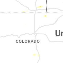
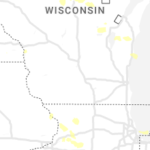
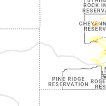
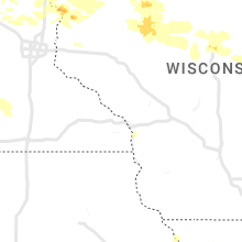
Hail Map for Thursday, July 27, 2023

Number of Impacted Households on 7/27/2023
0
Impacted by 1" or Larger Hail
0
Impacted by 1.75" or Larger Hail
0
Impacted by 2.5" or Larger Hail
Square Miles of Populated Area Impacted on 7/27/2023
0
Impacted by 1" or Larger Hail
0
Impacted by 1.75" or Larger Hail
0
Impacted by 2.5" or Larger Hail


Cities Most Affected by Hail Storms of 7/27/2023
| Hail Size | Demographics of Zip Codes Affected | ||||||
|---|---|---|---|---|---|---|---|
| City | Count | Average | Largest | Pop Density | House Value | Income | Age |
| Duluth, MN | 5 | 1.95 | 2.00 | 86 | $97k | $50.1k | 42.5 |
| Morgan, MN | 1 | 2.00 | 2.00 | 10 | $50k | $34.3k | 40.8 |
| Soda Springs, ID | 1 | 1.75 | 1.75 | 8 | $87k | $42.3k | 39.5 |
| Center City, MN | 1 | 1.75 | 1.75 | 77 | $133k | $48.1k | 42.8 |
| Midland, SD | 1 | 1.75 | 1.75 | 0 | $28k | $28.3k | 49.0 |
| Sturgeon Lake, MN | 1 | 1.75 | 1.75 | 22 | $100k | $37.8k | 45.7 |
Hail and Wind Damage Spotted on 7/27/2023
Filter by Report Type:Hail ReportsWind Reports
States Impacted
Minnesota, New York, New Hampshire, Massachusetts, West Virginia, Pennsylvania, Connecticut, Ohio, Wisconsin, Virginia, Maryland, Alabama, Idaho, South Dakota, Rhode Island, Arizona, Michigan, Kentucky, Wyoming, IllinoisMinnesota
| Local Time | Report Details |
|---|---|
| 7:00 AM CDT | Golf Ball sized hail reported near Center City, MN, 42.5 miles NNE of Minneapolis, MN, delayed report... time esimated from radar. hail quarter to golfball in almelund... with some vehicle damage reported. |
| 11:40 AM CDT | Report from mping: 3-inch tree limbs broken with time estimated based on rada in brown county MN, 74.5 miles SW of Minneapolis, MN |
| 3:15 PM CDT | Ping Pong Ball sized hail reported near Duluth, MN, 17.7 miles NNW of Duluth, MN, cocorahs station mn-sl-232. |
| 3:18 PM CDT | Some trees were snapped halfway up near the railroad tracks at mcquade road. time estimated by rada in st. louis county MN, 11.1 miles NE of Duluth, MN |
| 3:25 PM CDT | Hen Egg sized hail reported near Duluth, MN, 7.8 miles NNE of Duluth, MN |
| 3:30 PM CDT | Hen Egg sized hail reported near Duluth, MN, 7.4 miles NNE of Duluth, MN |
| 3:30 PM CDT | Quarter sized hail reported near Finlayson, MN, 55.7 miles SW of Duluth, MN |
| 3:33 PM CDT | Quarter sized hail reported near Duluth, MN, 4.1 miles NNE of Duluth, MN |
| 3:35 PM CDT | Quarter sized hail reported near Duluth, MN, 5.2 miles NE of Duluth, MN |
| 3:35 PM CDT | Hen Egg sized hail reported near Duluth, MN, 10.2 miles NE of Duluth, MN |
| 3:36 PM CDT | Ping Pong Ball sized hail reported near Duluth, MN, 10.3 miles NE of Duluth, MN, report from mping: ping pong ball (1.50 in.). |
| 3:37 PM CDT | Quarter sized hail reported near Duluth, MN, 7.2 miles NNE of Duluth, MN, also had trees down in the area. |
| 3:40 PM CDT | Ping Pong Ball sized hail reported near Duluth, MN, 10.3 miles NE of Duluth, MN, via social media. |
| 3:40 PM CDT | Quarter sized hail reported near Rush City, MN, 53.2 miles NNE of Minneapolis, MN, quarter sized hail reported 3 miles ne of rush city... mn. photo provided social media. |
| 3:44 PM CDT | Golf Ball sized hail reported near Duluth, MN, 8.2 miles NNE of Duluth, MN |
| 3:45 PM CDT | Report of several trees down 2 miles ese of rush city... mn. time estimated via rada in chisago county MN, 50.4 miles NNE of Minneapolis, MN |
| 3:50 PM CDT | Hen Egg sized hail reported near Duluth, MN, 10.6 miles NE of Duluth, MN |
| 3:51 PM CDT | Trained spotter reported numerous 8 to 10-inch diameter trees down across roadways and powerlines down. time estimated via rada in chisago county MN, 45.2 miles NNE of Minneapolis, MN |
| 3:53 PM CDT | Ping Pong Ball sized hail reported near Duluth, MN, 10.1 miles NNE of Duluth, MN |
| 4:20 PM CDT | Quarter sized hail reported near Finlayson, MN, 61.6 miles SW of Duluth, MN, half to one inch hail. |
| 4:34 PM CDT | Ping Pong Ball sized hail reported near Rush City, MN, 50.4 miles NNE of Minneapolis, MN, report from mping: ping pong ball (1.50 in.). |
| 4:45 PM CDT | Golf Ball sized hail reported near Sturgeon Lake, MN, 44.1 miles SW of Duluth, MN, heavy rain causing surface runoff and minor flooding. |
| 4:55 PM CDT | Quarter sized hail reported near Hinckley, MN, 68.8 miles SW of Duluth, MN |
| 5:01 PM CDT | Quarter sized hail reported near Hinckley, MN, 68.8 miles SW of Duluth, MN, corrects previous hail report from 3 w hinckley. |
| 5:10 PM CDT | Quarter sized hail reported near Morgan, MN, 53.4 miles SE of Montevideo, MN, corrects previous hail report from morgan. trained spotter measured quarter sized hail in the town of morgan... mn. time estimated via radar. |
| 5:10 PM CDT | Half Dollar sized hail reported near Morgan, MN, 53.8 miles SE of Montevideo, MN, phoned in report. mostly quarter size hail but one half dollar size hail stone observed. |
| 5:15 PM CDT | Hen Egg sized hail reported near Morgan, MN, 53.8 miles SE of Montevideo, MN, report sent via facebook. |
| 5:15 PM CDT | Quarter sized hail reported near Morgan, MN, 52.9 miles SE of Montevideo, MN, trained spotter reported quarter sized hail in morgan... mn. time estimated via radar. |
| 5:40 PM CDT | Quarter sized hail reported near Morgan, MN, 51.7 miles SE of Montevideo, MN, quarter sized hail measured 2 miles south of franklin... mn. photo provided via social media. time estimated via radar. |
| 7:00 PM CDT | Quarter sized hail reported near Hinckley, MN, 69.1 miles SW of Duluth, MN, estimated 4 inches of rainfall. |
| 7:12 PM CDT | Half Dollar sized hail reported near Stacy, MN, 32.6 miles NNE of Minneapolis, MN, most of the hail was nickel size. |
| 7:15 PM CDT | Quarter sized hail reported near Taylors Falls, MN, 43.4 miles NE of Minneapolis, MN, report received via amateur radio along co rd. 16 two miles north of taylors falls... mn. |
| 7:30 PM CDT | Half Dollar sized hail reported near Stacy, MN, 33.1 miles NNE of Minneapolis, MN, delayed report via facebook... mix of quarter to half dollar sized hail. |
| 8:50 PM CDT | Quarter sized hail reported near Litchfield, MN, 59.9 miles ENE of Montevideo, MN, report from mping: quarter (1.00 in.). time estimated via radar. |
| 9:30 PM CDT | Quarter sized hail reported near Lake Lillian, MN, 41.1 miles E of Montevideo, MN, emergency management reported quarter size hail in the city of lake lillian... mn. |
| 12:38 AM CDT | 10 inch diameter tree limb blocking roadway. delayed report via law enforcement. time estimated by rada in waseca county MN, 63.3 miles SSW of Minneapolis, MN |
New York
| Local Time | Report Details |
|---|---|
| 2:43 PM EDT | Tree down on wires in columbia county NY, 48.3 miles SSE of Schenectady, NY |
| 3:13 PM EDT | Trees and wires down on road via county dispatch. time estimated from rada in sullivan county NY, 60.4 miles ENE of Scranton, PA |
| 3:30 PM EDT | Trees and wires burning via county dispatch. time estimated from rada in sullivan county NY, 64.4 miles ENE of Scranton, PA |
| 4:18 PM EDT | Trees and wires down via county dispatch. time estimated from rada in sullivan county NY, 47.4 miles E of Scranton, PA |
| 4:36 PM EDT | Trees and wires burning on property via county dispatch. time estimated from rada in sullivan county NY, 56.3 miles ENE of Scranton, PA |
| 5:15 PM EDT | Roue 44 closed at townsend blvd due to tree down on wire in dutchess county NY, 71.2 miles N of Brooklyn, NY |
| 5:19 PM EDT | Trees and wires down blocking ridge rd. time estimated from rada in orange county NY, 53.1 miles NNW of Brooklyn, NY |
| 5:30 PM EDT | Route 82 closed in both directions due to downed trees and wires. wires down on a couple of occuppied vechile in dutchess county NY, 65.7 miles N of Brooklyn, NY |
| 5:35 PM EDT | Many poles... trees and wires down in the beekman area. one tree down on a she in dutchess county NY, 65 miles NNE of Brooklyn, NY |
| 5:38 PM EDT | Tree and wires down on quaker rd and evans av in orange county NY, 46.5 miles N of Brooklyn, NY |
| 5:51 PM EDT | Dot reports tree down on ny 129 eastbound at saw mill river road... lanes blocked. time estimated by rada in westchester county NY, 38.5 miles NNE of Brooklyn, NY |
New Hampshire
| Local Time | Report Details |
|---|---|
| 2:50 PM EDT | Large tree down on base hill rd. time estimated by rada in cheshire county NH, 83.1 miles E of Schenectady, NY |
| 3:00 PM EDT | Multiple trees down on dublin rd. road is close in cheshire county NH, 82 miles NNW of Providence, RI |
| 3:00 PM EDT | Trees and wires down on merrymen r in cheshire county NH, 82.4 miles NNW of Providence, RI |
| 3:00 PM EDT | Large tree down across main street. road is closed. time estimated by rada in cheshire county NH, 84.6 miles NNW of Providence, RI |
| 3:02 PM EDT | Quarter sized hail reported near Marlborough, NH, 86.2 miles NNW of Providence, RI, reported by weather spotter. quarter size hail reported in marlborough. time estimated by radar. |
| 3:10 PM EDT | Tree and wires down on cobb meadow r in cheshire county NH, 81.6 miles NNW of Providence, RI |
| 3:15 PM EDT | Quarter sized hail reported near Harrisville, NH, 83.6 miles NNW of Providence, RI, 1 inch hail observed falling for 4-5 mins. |
| 3:53 PM EDT | Delayed report: trees down near sheffield woods by jenkins road. time estimated by rada in hillsborough county NH, 75.2 miles N of Providence, RI |
| 4:02 PM EDT | Tree down on county roa in hillsborough county NH, 77.1 miles N of Providence, RI |
| 4:04 PM EDT | Delayed report: reported by amateur radio. trees down on spofford road. time estimated by rada in rockingham county NH, 72.3 miles SW of Portland, ME |
| 4:10 PM EDT | Large tree down partially blocking south mammoth street near the underpass. time estimated by rada in hillsborough county NH, 75.5 miles SW of Portland, ME |
| 4:10 PM EDT | Tree down partially blocking huse rd in the area of parkview condominiums dr. time estimated by rada in hillsborough county NH, 76.3 miles SW of Portland, ME |
| 4:28 PM EDT | Tree down on rattlesnake hill roa in rockingham county NH, 73.3 miles SW of Portland, ME |
Massachusetts
| Local Time | Report Details |
|---|---|
| 3:15 PM EDT | Tree down on wires clayton mill rver rd in berkshire county MA, 59.9 miles SE of Schenectady, NY |
| 3:16 PM EDT | Tree down across route 7 northbound... just north of salisbury ct lin in berkshire county MA, 61.2 miles SSE of Schenectady, NY |
| 3:16 PM EDT | Tree down on canaan southfield roa in berkshire county MA, 60.5 miles SE of Schenectady, NY |
| 3:34 PM EDT | Tree down across route 7 northbound... just north of salisbury ct lin in berkshire county MA, 61.2 miles SSE of Schenectady, NY |
| 3:34 PM EDT | Tree down on canaan southfield roa in berkshire county MA, 60.5 miles SE of Schenectady, NY |
| 3:56 PM EDT | Asos station kbaf westfield-barnes a in hampden county MA, 71.5 miles WNW of Providence, RI |
| 4:00 PM EDT | In westfield... numerous trees were down. two trees down on bates road by belden drive. single trees reported down on montgomery road... pochassic street... union stree in hampden county MA, 74.1 miles SE of Schenectady, NY |
| 4:12 PM EDT | In chicopee... a tree was down on grattan street. another tree was down at the intersection of granby road and springfield stree in hampden county MA, 65.2 miles WNW of Providence, RI |
| 4:12 PM EDT | In westfield... two trees were down on bates road by belden driv in hampden county MA, 74.1 miles SE of Schenectady, NY |
| 4:15 PM EDT | Corrects previous tstm wnd dmg report from 2 nw springfield. in springfield... a tree and wires were down in the 100 block of victoria street. also... a tree was partia in hampden county MA, 63.3 miles WNW of Providence, RI |
| 4:15 PM EDT | In west springfield... multiple limbs were down on park avenu in hampden county MA, 65.3 miles WNW of Providence, RI |
| 4:32 PM EDT | In palmer... a tree was down on power lines on maple street at maple terrac in hampden county MA, 55.1 miles WNW of Providence, RI |
| 4:44 PM EDT | In belchertown... a tree was down on wires on east stree in hampshire county MA, 56.1 miles WNW of Providence, RI |
| 4:55 PM EDT | In charlton... power lines were down on brookfield road near osgood roa in worcester county MA, 38.1 miles NW of Providence, RI |
| 5:56 PM EDT | In uxbridge... a tree was down on wires at west river road and hartford avenu in worcester county MA, 21.9 miles NNW of Providence, RI |
| 6:15 PM EDT | Tree down blocking mbta train track in norfolk county MA, 36.3 miles NE of Providence, RI |
| 6:39 PM EDT | Tree down on route 1 south in north attlebor in bristol county MA, 12 miles NNE of Providence, RI |
| 6:39 PM EDT | Tree down on kelley blv in bristol county MA, 13.1 miles NNE of Providence, RI |
| 6:39 PM EDT | Large tree down on power lines on lindsay st at arrowhead circle and bungay roa in bristol county MA, 13.3 miles NNE of Providence, RI |
| 6:40 PM EDT | Tree down on wires on berwick road in attleboroug in bristol county MA, 10.4 miles NNE of Providence, RI |
| 6:40 PM EDT | Tree down on wires near mechanic stree in bristol county MA, 10.2 miles NE of Providence, RI |
| 7:17 PM EDT | Lightning strike do building with damage. bricks all over mass av in suffolk county MA, 39.5 miles NNE of Providence, RI |
West Virginia
| Local Time | Report Details |
|---|---|
| 3:40 PM EDT | Quarter sized hail reported near Shenandoah Junction, WV, 65.7 miles W of Baltimore, MD, quarter size hail was reported near shenandoah junction and shepherdstown. |
| 3:40 PM EDT | Tree damage was reported near shepherdstown... including a large tree that blew down on private property along cr-16/1 gardners lan in jefferson county WV, 65.3 miles W of Baltimore, MD |
| 6:10 PM EDT | Several trees down along huntington road in gallipolis ferr in mason county WV, 40.6 miles NW of Charleston, WV |
Pennsylvania
| Local Time | Report Details |
|---|---|
| 3:51 PM EDT | Trees down on rush run roa in fayette county PA, 31.8 miles S of Pittsburgh, PA |
| 4:08 PM EDT | Wires dow in lackawanna county PA, 6.6 miles NNE of Scranton, PA |
| 4:10 PM EDT | Multiple trees dow in lackawanna county PA, 16.1 miles NE of Scranton, PA |
| 4:58 PM EDT | Trees down on wires near madison street & monroe stree in lackawanna county PA, 0 miles E of Scranton, PA |
| 5:06 PM EDT | High voltage power line down via county dispatch. time estimated from rada in lackawanna county PA, 6.6 miles ESE of Scranton, PA |
| 5:36 PM EDT | Trees down via county dispatch. time estimated from rada in wayne county PA, 14.5 miles SE of Scranton, PA |
| 5:40 PM EDT | Trees and wires down in pequea township... time estimated from rada in lancaster county PA, 50.5 miles NNE of Baltimore, MD |
| 5:40 PM EDT | Trees and wires down in providence township... time estimated from rada in lancaster county PA, 47.5 miles NNE of Baltimore, MD |
| 5:54 PM EDT | Tree fell bringing down power lines and a pole in a nearby alleyway via county dispatch. time estimated from rada in lackawanna county PA, 1.3 miles ENE of Scranton, PA |
| 6:20 PM EDT | Wires down reported at wilson road and doe run road in west marlborough township. time estimated from rada in chester county PA, 60.4 miles NE of Baltimore, MD |
| 6:25 PM EDT | A few trees down in the area of dennison and foster township in luzerne county PA, 25.4 miles SSW of Scranton, PA |
| 6:42 PM EDT | 911 call center relayed a report from a park ranger of a tree down in hickory run state park. time estimated from rada in carbon county PA, 25.6 miles S of Scranton, PA |
Connecticut
| Local Time | Report Details |
|---|---|
| 4:05 PM EDT | Trees and wires down moses mead rd in litchfield county CT, 64 miles SSE of Schenectady, NY |
| 4:38 PM EDT | Large tree down across riverside ave in litchfield county CT, 80.4 miles SSE of Schenectady, NY |
| 4:42 PM EDT | Tree down blocking one lane of torringford st in litchfield county CT, 81.5 miles SSE of Schenectady, NY |
| 5:00 PM EDT | In simsbury... a tree was down on corey roa in hartford county CT, 71.7 miles W of Providence, RI |
| 5:20 PM EDT | In west hartford... a tree was down on wires and a utility pole was snappe in hartford county CT, 68.6 miles W of Providence, RI |
| 5:25 PM EDT | In farmington... wires were downed on route 4 (farmington avenue) at highland road. new britain avenue was closed due to downed wires between plainville avenue (route 1 in hartford county CT, 74.2 miles W of Providence, RI |
| 5:25 PM EDT | In south windsor... power lines were down on the 100 block of oak stree in hartford county CT, 56.7 miles W of Providence, RI |
| 5:40 PM EDT | Tree down on north road in ashford. relayed by amateur radi in windham county CT, 37.3 miles W of Providence, RI |
| 5:50 PM EDT | In north windham... a tree was reported to be down on a mobile home... street not specifie in windham county CT, 38.4 miles W of Providence, RI |
| 5:50 PM EDT | Tree down on pilfershire and weeks roa in windham county CT, 34.5 miles W of Providence, RI |
| 6:00 PM EDT | In pomfret... a tree was down on wires on taft pond road. another tree was down on wires on wrights crossing roa in windham county CT, 31.6 miles W of Providence, RI |
| 6:00 PM EDT | 2 inch diameter tree limbed snapped from the top of a tree down on jonathan trumbull highwa in tolland county CT, 46.7 miles W of Providence, RI |
| 6:09 PM EDT | Several branches larger than 3 inches in diameter blown off trees. estimated wind gusts between 50 and 60mph.reported by trained spotte in windham county CT, 28.5 miles W of Providence, RI |
| 6:12 PM EDT | Sandy hook fire dept confirms fallen tree and wires on riverside rd. time estimated by rada in fairfield county CT, 63.9 miles NE of Brooklyn, NY |
| 6:30 PM EDT | Tree down on old willimantic rd. relayed by amateur radi in tolland county CT, 45 miles W of Providence, RI |
| 6:30 PM EDT | Tree down on wires on erdoni rd in columbia. relayed by amateur radi in tolland county CT, 48.6 miles W of Providence, RI |
| 6:32 PM EDT | In columbia... a tree and wires were down on route 87 and a tree and wires were down on lake roa in tolland county CT, 45.4 miles W of Providence, RI |
| 7:58 PM EDT | Report from mping: 3-inch tree limbs broken; power poles broke in windham county CT, 33.6 miles W of Providence, RI |
| 9:36 PM EDT | Tree down on wires on thompson hill rd in columbia. relayed by amateur radi in tolland county CT, 45.9 miles W of Providence, RI |
Ohio
| Local Time | Report Details |
|---|---|
| 4:18 PM EDT | Morrow-blackhawk road closed due to downed trees. time estimated from rada in warren county OH, 26.6 miles NE of Cincinnati, OH |
| 5:55 PM EDT | Gallia county 911 center advised they have reports of multiple trees down along plas road in raccoon township. time estimated from rada in gallia county OH, 57.2 miles NW of Charleston, WV |
| 6:06 PM EDT | Trees and wires knocked down onto car. time estimated from rada in hamilton county OH, 4.1 miles NNE of Cincinnati, OH |
| 6:08 PM EDT | Wires knocked down. time estimated from rada in hamilton county OH, 9.4 miles NNW of Cincinnati, OH |
| 6:15 PM EDT | Trees down on car in hamilton county OH, 7.3 miles ENE of Cincinnati, OH |
| 10:09 PM EDT | Downed tree limbs... approx. 3 inches in diameter... over werk roa in hamilton county OH, 8.7 miles WNW of Cincinnati, OH |
| 10:36 PM EDT | 2-3 inch diameter healthy tree limb dow in hamilton county OH, 6.4 miles ENE of Cincinnati, OH |
Wisconsin
| Local Time | Report Details |
|---|---|
| 3:20 PM CDT | Photos on social media of large 3-4 diameter tree snapped halfway up from its base. time estimated via rada in polk county WI, 52.3 miles NNE of Minneapolis, MN |
| 3:47 PM CDT | Ping Pong Ball sized hail reported near Danbury, WI, 45.3 miles S of Duluth, MN |
| 4:21 PM CDT | Numerous small branches and a few wrist size or larger branches down. time estimated from rada in sawyer county WI, 58.4 miles SE of Duluth, MN |
| 4:30 PM CDT | Quarter sized hail reported near Solon Springs, WI, 35.7 miles SE of Duluth, MN |
| 4:30 PM CDT | Reports multiple trees down uprooted and snapped at base. time estimated from rada in bayfield county WI, 52.9 miles ESE of Duluth, MN |
| 4:34 PM CDT | Many trees down brandt rd making the road impassible. time estimated from rada in sawyer county WI, 65.7 miles SE of Duluth, MN |
| 4:35 PM CDT | Amateur radio report of numerous 8-10 inch trees down 10 miles north of st. croix falls... wi. time approximated via rada in polk county WI, 50.1 miles NE of Minneapolis, MN |
| 4:35 PM CDT | Quarter sized hail reported near Saint Croix Falls, WI, 44.4 miles NE of Minneapolis, MN, measured report received from amateur radio. |
| 5:01 PM CDT | Aspen tree snapped halfway up. time estimated from rada in sawyer county WI, 60.3 miles SSE of Duluth, MN |
| 5:05 PM CDT | Multiple trees and large branches down on county road cc. some trees down over powerlines causing fires. time estimated from rada in sawyer county WI, 73 miles SE of Duluth, MN |
| 5:05 PM CDT | 10 inch diameter aspen tree snaped off 6ft off ground. time estimated by rada in sawyer county WI, 71.6 miles SE of Duluth, MN |
| 5:25 PM CDT | Tree down on powerline causing fire. time estimated via rada in sawyer county WI, 83.8 miles SSE of Duluth, MN |
| 6:34 PM CDT | 2-3 inch diameter branches dow in vilas county WI, 36.2 miles NNW of Rhinelander, WI |
| 6:56 PM CDT | Social media report with photos of a spruce tree top that had a diameter of approximately 8 inches. time estimated based on rada in oneida county WI, 11.7 miles W of Rhinelander, WI |
| 7:25 PM CDT | Half Dollar sized hail reported near Wausau, WI, 45 miles SSW of Rhinelander, WI, social media report with photos. time estimated based on radar. |
| 7:25 PM CDT | Report from social media with photos showing a pine tree snapped near the base. time estimated based on general range from observer and rada in marathon county WI, 48 miles SSW of Rhinelander, WI |
| 7:27 PM CDT | Quarter sized hail reported near Wausau, WI, 48 miles SSW of Rhinelander, WI, via social media post. |
| 7:30 PM CDT | Quarter sized hail reported near Wausau, WI, 47.3 miles SSW of Rhinelander, WI, dime to quarter size hail from social media report photos. |
| 7:30 PM CDT | Half Dollar sized hail reported near Wausau, WI, 46.4 miles SSW of Rhinelander, WI |
| 7:40 PM CDT | Half Dollar sized hail reported near Schofield, WI, 50.9 miles S of Rhinelander, WI |
| 7:45 PM CDT | Quarter sized hail reported near Gilman, WI, 75.3 miles WSW of Rhinelander, WI, also strong winds estimated to 70 mph. |
| 8:00 PM CDT | Quarter sized hail reported near Ringle, WI, 51 miles S of Rhinelander, WI, social media photo showing estimated hail a quarter in size. |
| 9:00 PM CDT | Report of tree on power line resulting in loss of power in black creek per outagamie so dispatch from gust front moving through the immediate are in outagamie county WI, 21.6 miles W of Green Bay, WI |
| 9:10 PM CDT | Reports of tree on power line and another tree down per outagamie so dispatch from gust front moving through the immediate are in outagamie county WI, 15.8 miles W of Green Bay, WI |
Virginia
| Local Time | Report Details |
|---|---|
| 4:48 PM EDT | Trees blew down near the intersection of va-694 john wolford road/the narrows road and va-681 milltown roa in loudoun county VA, 55 miles W of Baltimore, MD |
| 4:48 PM EDT | Trees blew down near the intersection of va-681 milltown road and va-682 rodeffer roa in loudoun county VA, 54.8 miles W of Baltimore, MD |
| 5:14 PM EDT | Several trees blew down in the city of wincheste in frederick county VA, 83.5 miles W of Baltimore, MD |
| 5:17 PM EDT | A wind gust of 60 knots (69 mph) was measured by the awos at winchester regional airport (kokv in frederick county VA, 82.8 miles W of Baltimore, MD |
| 5:29 PM EDT | Trees blew down near the intersection of va-848 holmes mill road and va-704 harmony church roa in loudoun county VA, 57.7 miles WSW of Baltimore, MD |
| 5:34 PM EDT | Trees blew down on us-15 james monroe highway/monroe-madison memorial highway between va-651 hogback mountain road and va-704 harmony church roa in loudoun county VA, 56 miles WSW of Baltimore, MD |
| 5:34 PM EDT | Multiple trees down on locks mill road along the shenandoah rive in clarke county VA, 74.2 miles W of Baltimore, MD |
| 5:42 PM EDT | Trees blew down near the intersection of va-765 ridgeside road and va-626 foggy bottom roa in loudoun county VA, 67.1 miles WSW of Baltimore, MD |
| 6:00 PM EDT | Several trees and wires blew down around leesbur in loudoun county VA, 52.7 miles WSW of Baltimore, MD |
| 6:15 PM EDT | Trees and wires blew down in middlebur in loudoun county VA, 64.6 miles WSW of Baltimore, MD |
| 6:15 PM EDT | Photo of multiple trees down in ashburn on gala circl in loudoun county VA, 49.4 miles WSW of Baltimore, MD |
| 6:18 PM EDT | Trees blew down along va-629 cobb house roa in loudoun county VA, 60.9 miles WSW of Baltimore, MD |
| 6:31 PM EDT | Trees blew down on east frederick drive near maywood terrace/woodstone terrac in loudoun county VA, 45.7 miles WSW of Baltimore, MD |
Maryland
| Local Time | Report Details |
|---|---|
| 5:11 PM EDT | Several trees and wires blew down near dickerson... including near the intersection of md-28 dickerson road and martinsburg roa in montgomery county MD, 44.9 miles W of Baltimore, MD |
| 5:25 PM EDT | Md-117 bucklodge road was closed in both directions due to downed trees near md-28 darnestown roa in montgomery county MD, 41.4 miles WSW of Baltimore, MD |
Alabama
| Local Time | Report Details |
|---|---|
| 5:15 PM CDT | Several trees blown down with some large branches broken. the roof was blown off of a metal building structure. possible microburs in calhoun county AL, 62.3 miles ENE of Birmingham, AL |
Idaho
| Local Time | Report Details |
|---|---|
| 4:45 PM MDT | Golf Ball sized hail reported near Soda Springs, ID, 66.7 miles SSE of Idaho Falls, ID, photo submitted from south of soda springs along the caribou/bear lake co. line. time estimated by radar. |
South Dakota
| Local Time | Report Details |
|---|---|
| 4:50 PM MDT | Storm damage reported in fall river county SD, 62.6 miles S of Rapid City, SD |
| 6:21 PM MDT | Storm damage reported in jackson county SD, 72.3 miles ESE of Rapid City, SD |
| 6:31 PM MDT | Storm damage reported in jackson county SD, 72.3 miles ESE of Rapid City, SD |
| 6:41 PM MDT | Storm damage reported in oglala lakota county SD, 72.8 miles SE of Rapid City, SD |
| 6:51 PM MDT | Storm damage reported in jackson county SD, 49.4 miles SW of Pierre, SD |
| 7:00 PM MDT | Golf Ball sized hail reported near Midland, SD, 36.5 miles W of Pierre, SD |
| 7:01 PM MDT | Storm damage reported in jackson county SD, 49.4 miles SW of Pierre, SD |
| 8:28 PM CDT | Storm damage reported in todd county SD, 43.2 miles NW of Valentine, NE |
| 9:00 PM CDT | Storm damage reported in mellette county SD, 42.6 miles N of Valentine, NE |
| 9:00 PM CDT | Quarter sized hail reported near Wood, SD, 42.6 miles N of Valentine, NE |
Rhode Island
| Local Time | Report Details |
|---|---|
| 7:02 PM EDT | Report from mping: 3-inch tree limbs broken; power poles broke in providence county RI, 14.9 miles WNW of Providence, RI |
| 7:45 PM EDT | Tree down on plainfield pike in coventry blocking the entrance to carbuncle pon in kent county RI, 20.8 miles WSW of Providence, RI |
| 7:59 PM EDT | Tree down on wires on pleasant street. time estimated from rada in washington county RI, 37.5 miles SW of Providence, RI |
Arizona
| Local Time | Report Details |
|---|---|
| 4:15 PM MST | Corrects previous non-tstm wnd gst report from 3 sse patagonia. mesonet station gw3161 patagoni in santa cruz county AZ, 51 miles SSE of Tucson, AZ |
| 4:30 PM MST | Approximately 9 tractor trailer rigs were blown over and/or jackknifed along i-10 near vicksburg rd. this occurred at two to three locations from milepost 41 to milepos in la paz county AZ, 66.3 miles SSE of Lake Havasu City, AZ |
| 8:25 PM MST | Mesonet station cw8733 tucson snyder/soldier trai in pima county AZ, 14.8 miles ENE of Tucson, AZ |
| 9:19 PM MST | Mesonet station qhpa3 hopkin in santa cruz county AZ, 37.7 miles S of Tucson, AZ |
| 10:19 PM MST | Mesonet station qhpa3 hopkin in santa cruz county AZ, 37.7 miles S of Tucson, AZ |
Michigan
| Local Time | Report Details |
|---|---|
| 7:19 PM EDT | Corrects time of previous tstm wnd dmg report from ewen. ontonagon county dispatch reports a few trees of unknown size down on power lines in ewe in ontonagon county MI, 61.9 miles N of Rhinelander, WI |
| 7:19 PM EDT | Corrects time of previous tstm wnd dmg report from ewen. ontonagon county dispatch reports a few trees of unknown size down on power lines in ewe in ontonagon county MI, 61.9 miles N of Rhinelander, WI |
| 7:41 PM EDT | Ontonagon county dispatch reports a few trees of unknown size down on power lines in ewe in ontonagon county MI, 61.9 miles N of Rhinelander, WI |
| 8:54 PM EDT | Corrects time of previous tstm wnd dmg report from 1 n marquette. marquette county central dispatch reports trees down and power lines downed on wilkinson street in nor in marquette county MI, 1.8 miles NNE of Marquette, MI |
| 8:54 PM EDT | Corrects time of previous tstm wnd dmg report from 1 ssw marquette. marquette county central dispatch reports downed tree on a vehicle on altamont street in marquett in marquette county MI, 0.8 miles ESE of Marquette, MI |
| 8:54 PM EDT | Marquette county central dispatch reports a tree on power lines off midway drive in negaunee township. max wind gust at wfo was 47 mph just a few minutes previous to th in marquette county MI, 5.1 miles W of Marquette, MI |
| 8:56 PM EDT | Corrects time of previous tstm wnd dmg report from 1 wnw harvey. marquette county central dispatch reports trees and power lines downed along reservoir street and quarr in marquette county MI, 4.1 miles SE of Marquette, MI |
| 9:07 PM EDT | Marquette county central dispatch reports trees down and power lines downed on wilkinson street in north marquett in marquette county MI, 1.8 miles NNE of Marquette, MI |
| 9:36 PM EDT | Marquette county central dispatch reports downed tree on a vehicle on altamont street in marquett in marquette county MI, 0.8 miles ESE of Marquette, MI |
| 9:46 PM EDT | Marquette county central dispatch reports trees and power lines downed along reservoir street and quarry road in harve in marquette county MI, 4.1 miles SE of Marquette, MI |
Kentucky
| Local Time | Report Details |
|---|---|
| 8:02 PM EDT | Rowan county dispatch reported a tree blown down along the 1700 block of christy creek. time estimated by rada in rowan county KY, 46.9 miles NE of Irvine, KY |
| 8:30 PM EDT | Rowan county dispatch reported a tree blown down onto moores flat rd in the 1100 block. time estimated from rada in rowan county KY, 39.6 miles NE of Irvine, KY |
| 9:18 PM EDT | Multiple trees and branches down across squiresville roa in owen county KY, 45.9 miles SSW of Cincinnati, OH |
| 9:27 PM EDT | Montgomery county dispatch reported several trees blown down onto cecil rd. time estimated from rada in montgomery county KY, 31.7 miles N of Irvine, KY |
| 9:27 PM EDT | A few trees were downed. time estimated from rada in owen county KY, 41.2 miles SW of Cincinnati, OH |
| 9:28 PM EDT | Montgomery county dispatch reported a power line blown down in the 7000 block of maysville rd. time estimated from rada in montgomery county KY, 31 miles N of Irvine, KY |
| 9:47 PM EDT | Montgomery county dispatch reported a tree blown down onto stepstone rd near the bath/montgomery county line. time estimated from rada in montgomery county KY, 28 miles NNE of Irvine, KY |
| 9:52 PM EDT | Montgomery county dispatch reported a tree blown down around the intersection of bedford and town branch roads. time estimated from rada in montgomery county KY, 23.4 miles NNE of Irvine, KY |
| 10:02 PM EDT | A few trees were downed along river road. time estimated from rada in boone county KY, 12.9 miles W of Cincinnati, OH |
Wyoming
| Local Time | Report Details |
|---|---|
| 10:11 PM MDT | Asos station kcpr casper airpor in natrona county WY, 8 miles WNW of Casper, WY |
Illinois
| Local Time | Report Details |
|---|---|
| 2:17 AM CDT | Measured via anemomete in ogle county IL, 75.4 miles S of Madison, WI |
| 2:24 AM CDT | Lee county sheriffs office reports tree damage across lee county with the worst in dixon and ashton. time estimated by rada in lee county IL, 79.4 miles N of Peoria, IL |
| 2:45 AM CDT | Storm damage reported in lee county IL, 70.4 miles NNE of Peoria, IL |
| 3:15 AM CDT | Storm damage reported in ogle county IL, 76.1 miles S of Madison, WI |
| 3:48 AM CDT | Large tree branch broken off as well as a flag pole knocked over. time estimated by radar and time of repor in whiteside county IL, 70.4 miles N of Peoria, IL |
| 5:10 AM CDT | Corrects time of previous tstm wnd gst report from 2 ssw milfor in iroquois county IL, 84.6 miles NNE of Mattoon, IL |
| 5:18 AM CDT | Storm damage reported in iroquois county IL, 84.6 miles NNE of Mattoon, IL |
Connect with Interactive Hail Maps