

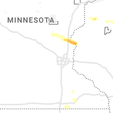
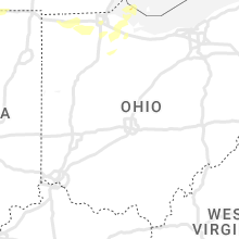
Hail Map for Wednesday, July 26, 2023

Number of Impacted Households on 7/26/2023
0
Impacted by 1" or Larger Hail
0
Impacted by 1.75" or Larger Hail
0
Impacted by 2.5" or Larger Hail
Square Miles of Populated Area Impacted on 7/26/2023
0
Impacted by 1" or Larger Hail
0
Impacted by 1.75" or Larger Hail
0
Impacted by 2.5" or Larger Hail


Cities Most Affected by Hail Storms of 7/26/2023
| Hail Size | Demographics of Zip Codes Affected | ||||||
|---|---|---|---|---|---|---|---|
| City | Count | Average | Largest | Pop Density | House Value | Income | Age |
| Fort Pierre, SD | 1 | 1.75 | 1.75 | 2 | $85k | $41.6k | 41.8 |
| Brady, NE | 1 | 1.75 | 1.75 | 3 | $79k | $33.5k | 41.1 |
Hail and Wind Damage Spotted on 7/26/2023
Filter by Report Type:Hail ReportsWind Reports
States Impacted
Illinois, Iowa, Minnesota, Wisconsin, Indiana, Michigan, Ohio, Colorado, Wyoming, Utah, Nebraska, Pennsylvania, Florida, North Dakota, Arizona, South Dakota, New York, Kansas, New MexicoIllinois
| Local Time | Report Details |
|---|---|
| 7:17 AM CDT | Storm damage reported in jo daviess county IL, 56 miles SW of Madison, WI |
| 7:44 AM CDT | Report of a shed blown down along with a power outage. time estimated by rada in stephenson county IL, 42.5 miles S of Madison, WI |
| 8:15 AM CDT | Tree branches and limbs reported down... as well as power lines down and power outages across are in winnebago county IL, 52.9 miles SSE of Madison, WI |
| 8:15 AM CDT | Report of trees and limbs down. estimated size between 5-8 inche in winnebago county IL, 54.6 miles SSE of Madison, WI |
| 8:29 AM CDT | Poplar grove airpor in boone county IL, 59 miles SSE of Madison, WI |
| 8:30 AM CDT | Photos of a large healthy pine tree near one foot in diameter snapped along with several 6 inch diameter limbs dow in boone county IL, 59.5 miles SSE of Madison, WI |
| 8:40 AM CDT | Report of a large tree downed onto power lines. diameter estimated 6-8 inche in mchenry county IL, 56.6 miles WNW of Chicago, IL |
| 8:43 AM CDT | Part of tree uprooted near flagg lane and hickman lane. time estimated by rada in mchenry county IL, 50.9 miles NW of Chicago, IL |
| 8:53 AM CDT | Downed power lines on il-59 north of fox lake hills. time estimated by rada in lake county IL, 45.2 miles NNW of Chicago, IL |
| 9:01 AM CDT | Power lines downed on us-12 near old mchenry. highway closed with traffic being rerouted. time estimated by rada in lake county IL, 35.1 miles NW of Chicago, IL |
| 9:04 AM CDT | Fairfield road blocked north of old mchenry due to downed tree branches. time estimated by rada in lake county IL, 32.8 miles NW of Chicago, IL |
| 9:10 AM CDT | Report of multiple trees downed off 57 and lake street. 8-12 inches in diamete in lake county IL, 32.7 miles NNW of Chicago, IL |
Iowa
| Local Time | Report Details |
|---|---|
| 7:17 AM CDT | Tree branches broken as well as one large tree that was snapped near the base. time estimated by rada in scott county IA, 67.4 miles ESE of Cedar Rapids, IA |
Minnesota
| Local Time | Report Details |
|---|---|
| 7:26 AM CDT | Asos station krst rochester international airpor in olmsted county MN, 62.6 miles W of La Crosse, WI |
| 12:07 AM CDT | Quarter sized hail reported near Mentor, MN, 61.3 miles NNE of Fargo, ND, report of 1 inch hail... duration about 5 minutes. time estimated using radar. |
| 12:21 AM CDT | Ping Pong Ball sized hail reported near Erskine, MN, 54.4 miles WNW of Bemidji, MN, media relayed a report of 1.5 inch hail in erskine... mn. time estimated via radar. |
| 12:35 AM CDT | Ping Pong Ball sized hail reported near Gully, MN, 40.2 miles WNW of Bemidji, MN, ping pong ball sized hail reported in gully... mn. relayed via social media. time estimated via radar. |
| 12:44 AM CDT | Ping Pong Ball sized hail reported near Gully, MN, 40.2 miles WNW of Bemidji, MN, corrects previous hail report from gully. ping pong ball sized hail reported in gully... mn. relayed via social media. time estimated via radar. |
| 6:36 AM CDT | Quarter sized hail reported near Harris, MN, 43.3 miles NNE of Minneapolis, MN, time estimated based on radar. |
Wisconsin
| Local Time | Report Details |
|---|---|
| 8:00 AM CDT | Trees down at highway q near highway 21 in rock county WI, 42.3 miles SSE of Madison, WI |
| 10:00 AM CDT | Half of roof was peeled off a pole bar in grant county WI, 56.7 miles WSW of Madison, WI |
| 10:02 AM CDT | Some trees down and power outage in grant county WI, 60 miles WSW of Madison, WI |
| 10:11 AM CDT | Lafayette co. dispatch relayed multiple reports of trees down in the belmont area... along with a grain bin on county rd g that had been tipped on power lines by win in lafayette county WI, 53.1 miles WSW of Madison, WI |
| 10:11 AM CDT | Iowa county dispatch relayed report of tree down on jones branch road. time estimated from rada in iowa county WI, 50.4 miles WSW of Madison, WI |
| 10:16 AM CDT | Lafayette county dispatch relays report of tree down on county road g and bethel grove road. time estimated from rada in lafayette county WI, 51.6 miles WSW of Madison, WI |
| 10:56 AM CDT | Green county dispatch reports multiple trees down in brooklyn and along state road 104. time estimated from rada in green county WI, 15.4 miles S of Madison, WI |
| 10:56 AM CDT | Green county dispatch reports tree down on power lines southeast of monroe. time estimated from rada in green county WI, 35.9 miles SSW of Madison, WI |
| 11:15 AM CDT | Reports of trees down near evansville. time estimated from rada in rock county WI, 20.7 miles SSE of Madison, WI |
| 11:34 AM CDT | 2-3 inch diameter branches down in elkhorn. time estimated from rada in walworth county WI, 51.2 miles ESE of Madison, WI |
| 11:49 AM CDT | Trees and wires down from northern burlington up toward waterford. time estimated from rada in racine county WI, 63 miles ESE of Madison, WI |
| 12:25 PM CDT | Reports of multiple trees and wires down across racine count in racine county WI, 57.7 miles NNW of Chicago, IL |
Indiana
| Local Time | Report Details |
|---|---|
| 11:15 AM CDT | Multiple reports of trees down on ohio street in michigan city... near the intersection with garfield street. no specifics of the size of trees. time estimated via rada in la porte county IN, 39.9 miles ESE of Chicago, IL |
| 1:44 PM EDT | 24 to 30 inch diameter tree down at the intersection of sr 120 and 900w. time estimated via rada in steuben county IN, 45.3 miles N of Fort Wayne, IN |
| 1:49 PM EDT | Multiple trees down in topeka... i in lagrange county IN, 39.4 miles NW of Fort Wayne, IN |
| 1:50 PM EDT | 4 healthy trees/branches down... largest 12 inches in diameter at ln 3 and 3rd stree in lagrange county IN, 47.5 miles NNW of Fort Wayne, IN |
| 1:50 PM EDT | Damage to roofs on two barns in topeka. time estimated via radar. photo on twitte in lagrange county IN, 39.4 miles NW of Fort Wayne, IN |
| 9:40 PM EDT | Emergency manager reports multiple trees dow in lagrange county IN, 42.4 miles NNW of Fort Wayne, IN |
| 9:56 PM EDT | Corrects previous non-tstm wnd gst report from 2 nw benton. asos station kgsh goshe in elkhart county IN, 47.3 miles NW of Fort Wayne, IN |
Michigan
| Local Time | Report Details |
|---|---|
| 1:25 PM EDT | Large tree down in sturgis... mi at the intersection of south ottawa street and cottage road. time estimated via rada in st. joseph county MI, 52 miles NNW of Fort Wayne, IN |
| 1:30 PM EDT | Multiple trees down in sturgis along hwy 6 in st. joseph county MI, 52.7 miles NNW of Fort Wayne, IN |
| 1:30 PM EDT | Numerous trees snapped and/or uprooted in burr oak. time estimated by radar. photos on twitte in st. joseph county MI, 54.7 miles NNW of Fort Wayne, IN |
| 1:30 PM EDT | Tree limbs down... fence damaged... and a house with siding damage in sturgis on bogen rd. time estimated via rada in st. joseph county MI, 50.7 miles NNW of Fort Wayne, IN |
| 1:45 PM EDT | Delayed report. trained spotter estimates wind gusts 60 mph at olds rd and union city r in branch county MI, 65.9 miles N of Fort Wayne, IN |
| 1:48 PM EDT | A few large tree branches down in cassopolis... including one onto an unoccupied car. time estimated from rada in cass county MI, 74.5 miles NW of Fort Wayne, IN |
| 1:55 PM EDT | Large tree limbs down onto powerlines on the south side of diamond lake along diamond view drive. time estimated via rada in cass county MI, 73 miles NW of Fort Wayne, IN |
| 2:24 PM EDT | Several trees down and/or uprooted in somerset center in mccourtie park. time estimated from radar. several photos on twitte in hillsdale county MI, 75.9 miles SSW of Flint, MI |
| 2:25 PM EDT | Several large tree branches down. a few trees also downed. time estimated from rada in hillsdale county MI, 73.5 miles NNE of Fort Wayne, IN |
| 2:25 PM EDT | Spotter reports numerous large trees uprooted or down at the trailer park in somerset center. time estimated via radar. photos on twitte in hillsdale county MI, 75.9 miles NNE of Fort Wayne, IN |
| 2:30 PM EDT | Delayed report. several large trees snapped on jerome road and at the jerome rd and sandhill rd intersectio in hillsdale county MI, 73.1 miles NNE of Fort Wayne, IN |
| 2:36 PM EDT | Dispatch reports numerous trees and power lines down in the morenci are in lenawee county MI, 63.8 miles NE of Fort Wayne, IN |
| 2:40 PM EDT | Reports of trees and wires down in hanover... liberty... and columbia township in jackson county MI, 71.3 miles SSW of Flint, MI |
| 2:50 PM EDT | Multiple trees down across the area. a couple trees blocking roadway in washtenaw county MI, 52.9 miles SSW of Flint, MI |
| 2:59 PM EDT | Em reports large tree down on a house with an individual trapped inside. time estimated by rada in washtenaw county MI, 46.9 miles S of Flint, MI |
| 3:00 PM EDT | Report of multiple trees and tree limbs down near the intersection of woodland and east industria in washtenaw county MI, 56.8 miles S of Flint, MI |
| 3:02 PM EDT | Report of a large tree limb down on a roof of a house near the intersection of pontiac and barto in washtenaw county MI, 49.1 miles S of Flint, MI |
| 3:03 PM EDT | Report of a large tree down near the intersection of prairie street and briarcliff stree in washtenaw county MI, 49.1 miles S of Flint, MI |
| 3:03 PM EDT | Dispatch reports numerous trees and power lines down across pinckne in livingston county MI, 41 miles SSW of Flint, MI |
| 3:10 PM EDT | Dispatch reports numerous trees and power lines down near howel in livingston county MI, 30.5 miles SSW of Flint, MI |
| 3:13 PM EDT | Report of trees down near the intersection of wear and elwell. time estimated by rada in wayne county MI, 61.5 miles S of Flint, MI |
| 3:16 PM EDT | Storm damage reported in wayne county MI, 56.9 miles SSE of Flint, MI |
| 3:16 PM EDT | Storm damage reported in wayne county MI, 53.8 miles S of Flint, MI |
| 3:20 PM EDT | Report of large trees down near the off ramp of i-96 and levan. time estimated by rada in wayne county MI, 45.9 miles SSE of Flint, MI |
| 3:20 PM EDT | Multiple trees down across the cit in monroe county MI, 85.8 miles S of Flint, MI |
| 3:20 PM EDT | Report of large trees down near i-94 and wayne road. time estimated by rada in wayne county MI, 56 miles SSE of Flint, MI |
| 3:20 PM EDT | Report of large tree limbs down near the intersection of ford and merriman road. time estimated by rada in wayne county MI, 50 miles SSE of Flint, MI |
| 3:22 PM EDT | Report of large trees uprooted near levan and 5 mile. time estimated by rada in wayne county MI, 45.1 miles SSE of Flint, MI |
| 3:22 PM EDT | Report of a tree limb inside the roof of a home near the intersection of joy and middlebelt. time estimated by rada in wayne county MI, 49.1 miles SSE of Flint, MI |
| 3:25 PM EDT | Measured at m-24 mi us midot mesone in wayne county MI, 44.8 miles SSE of Flint, MI |
| 3:25 PM EDT | Report of trees down near the intersection of bennett and oxford. time estimated by rada in wayne county MI, 54.3 miles SSE of Flint, MI |
| 3:26 PM EDT | Report of large trees down near the intersection of 7 mile and beech daly. time estimated by rada in wayne county MI, 44.6 miles SSE of Flint, MI |
| 3:30 PM EDT | Multiple trees down across the cit in monroe county MI, 84.8 miles S of Flint, MI |
| 3:30 PM EDT | Report of large trees down near the intersection of 9 mile and beech. time estimated by rada in oakland county MI, 44 miles SSE of Flint, MI |
| 3:31 PM EDT | Reports of numerous large trees down inlcuding some damage to houses and cars near evergreen and 10 mile. time estimated based on rada in oakland county MI, 43.7 miles SSE of Flint, MI |
| 3:34 PM EDT | Report of large trees down near the intersection of 12 mile and southfield road. time estimated by rada in oakland county MI, 42.5 miles SE of Flint, MI |
| 3:40 PM EDT | Tree down on a hous in monroe county MI, 76.8 miles SSE of Flint, MI |
| 3:40 PM EDT | Tree down on a house in monroe townshi in monroe county MI, 78.1 miles S of Flint, MI |
| 3:50 PM EDT | Reports of numerous trees down in grosse pointe. time estimated by rada in wayne county MI, 58.3 miles SE of Flint, MI |
| 3:54 PM EDT | Measured via mesonet at grosse pointe yacht clu in lcz460 county MI, 57.7 miles SE of Flint, MI |
| 3:56 PM EDT | 6 inch diameter tree down at the tv statio in oakland county MI, 39.2 miles SSE of Flint, MI |
| 3:56 PM EDT | Large tree down in macomb county MI, 44.7 miles SE of Flint, MI |
| 4:20 PM EDT | Report of multiple trees down in harsens island and clay townshi in st. clair county MI, 62.2 miles ESE of Flint, MI |
| 6:12 PM EDT | Spotter estimates 70 mph wind gusts. trees down and crops blown ove in st. joseph county MI, 62.2 miles N of Fort Wayne, IN |
| 6:23 PM EDT | Trees and wires dow in calhoun county MI, 64.5 miles SSE of Grand Rapids, MI |
| 6:23 PM EDT | Trees and wires dow in calhoun county MI, 66.4 miles SSE of Grand Rapids, MI |
| 6:48 PM EDT | Multiple power outages per consumers energy outage ma in calhoun county MI, 72.5 miles SE of Grand Rapids, MI |
| 6:50 PM EDT | Multiple power outages reported in the area by consumers energ in jackson county MI, 74.1 miles NNE of Fort Wayne, IN |
| 7:39 PM EDT | Twitter report of trees and powerlines down in union city. m60 is shut down by michigan state police as it is almost impassable in spot in branch county MI, 67.6 miles SSE of Grand Rapids, MI |
Ohio
| Local Time | Report Details |
|---|---|
| 2:40 PM EDT | Photos on twitter depict several large tree limbs and one large tree down in edgerton. near the intersection of north michigan avenue and gas street. time estimated by in williams county OH, 31.6 miles NE of Fort Wayne, IN |
| 2:40 PM EDT | Large tree limbs snapped in west unity. photo on facebook. tim estimated via rada in williams county OH, 49.7 miles NE of Fort Wayne, IN |
| 3:04 PM EDT | Emergency manager reports tree down on the henry/fulton county line. near the intersection of co rd 13 and county rd in fulton county OH, 58.4 miles ENE of Fort Wayne, IN |
| 3:14 PM EDT | Numerous downed trees and limbs. time estimated via rada in lucas county OH, 85.3 miles ENE of Fort Wayne, IN |
| 3:16 PM EDT | Large tree snapped causing damage to a house in point plac in lucas county OH, 89.8 miles S of Flint, MI |
| 3:18 PM EDT | On cr 6 between cr u and u-4 approx 0.5 miles of downed trees and power lines downed and smoking. time estimated by rada in henry county OH, 64 miles ENE of Fort Wayne, IN |
| 3:20 PM EDT | Power poles and wires down in downtown toled in lucas county OH, 88.7 miles ENE of Fort Wayne, IN |
| 3:20 PM EDT | Large tree limbs down near monroe street and secor roa in lucas county OH, 87.8 miles ENE of Fort Wayne, IN |
| 3:27 PM EDT | Large tree limb downed in southwest toledo. time estimated via rada in lucas county OH, 88.7 miles ENE of Fort Wayne, IN |
| 3:29 PM EDT | Damage to a building on airport highway with power poles dow in lucas county OH, 81.1 miles ENE of Fort Wayne, IN |
| 3:30 PM EDT | Minor roof damage to a residence. time estimated via rada in lucas county OH, 90.2 miles ENE of Fort Wayne, IN |
| 3:39 PM EDT | Large tree uprooted on secor roa in lucas county OH, 88.8 miles ENE of Fort Wayne, IN |
| 3:40 PM EDT | Mesonet station 45200 4 ne orego in lez142 county OH, 88.2 miles W of Cleveland, OH |
| 3:44 PM EDT | Numerous trees and power lines down in bowling gree in wood county OH, 78.4 miles ENE of Fort Wayne, IN |
| 3:49 PM EDT | Numerous trees reported downed in pemberville...especially near the intersection of route 199 and 105. time estimated via rada in wood county OH, 88.4 miles ENE of Fort Wayne, IN |
| 3:56 PM EDT | Quarter sized hail reported near Genoa, OH, 84.5 miles W of Cleveland, OH, report from mping: quarter (1.00 in.). |
| 4:10 PM EDT | Mesonet station sbio1 on south bass island or 9 ne port clinto in ottawa county OH, 60.2 miles W of Cleveland, OH |
| 4:20 PM EDT | Reports of trees down in lakeside marblehead. time is estimated via rada in ottawa county OH, 55 miles W of Cleveland, OH |
| 4:24 PM EDT | C-man station mrho1 measured a 58 kt wind gus in lez143 county OH, 54 miles W of Cleveland, OH |
| 4:37 PM EDT | At least one tree and some limbs down in margaretta twp. time estimated via rada in erie county OH, 58.6 miles W of Cleveland, OH |
| 4:37 PM EDT | Large tree uprooted on cleveland road. time estimated via rada in erie county OH, 46.6 miles W of Cleveland, OH |
| 4:42 PM EDT | Tree downed along state route 269. time estimated via rada in erie county OH, 59.4 miles W of Cleveland, OH |
| 4:48 PM EDT | Dispatch has received numerous calls for downed trees and wires in erie county... especially north of the turnpik in erie county OH, 48.9 miles W of Cleveland, OH |
| 5:05 PM EDT | Multiple trees and limbs downed along route 2 between vermillion and huron. time estimated via rada in erie county OH, 40 miles WSW of Cleveland, OH |
| 5:06 PM EDT | Poles and wires down on lorain road at sparky lan in cuyahoga county OH, 13.3 miles WSW of Cleveland, OH |
| 5:08 PM EDT | Tree down on n park drive in fairview park. report via social media. time estimated via rada in cuyahoga county OH, 9.9 miles WSW of Cleveland, OH |
| 5:22 PM EDT | Mesonet station xvrm vermilio in lez145 county OH, 35.1 miles W of Cleveland, OH |
| 5:30 PM EDT | C-man station vrmo1 2 wnw vermilion measured a 57 kt wind gus in lez145 county OH, 35.1 miles W of Cleveland, OH |
| 5:32 PM EDT | Trees downed on house in painesville... causing significant damage to the house. time estimated via rada in lake county OH, 27.2 miles ENE of Cleveland, OH |
| 5:32 PM EDT | Tree and wires down on pleasant valley road in willoughby hills. time estimated via rada in lake county OH, 16.2 miles ENE of Cleveland, OH |
| 5:33 PM EDT | Large limb downed with gust front wind in lake county OH, 27.2 miles ENE of Cleveland, OH |
| 7:26 PM EDT | Portage county dispatch reported numerous trees down near and southeast of the city of ravenna. time is estimated via rada in portage county OH, 34.2 miles SE of Cleveland, OH |
Colorado
| Local Time | Report Details |
|---|---|
| 2:17 PM MDT | Quarter sized hail reported near Elbert, CO, 44.4 miles SSE of Denver, CO, report from mping: quarter (1.00 in.). |
| 6:41 PM MDT | Storm damage reported in yuma county CO, 9 miles SSE of Yuma, CO |
| 6:43 PM MDT | Weatherlink rmr ranc in yuma county CO, 9 miles SSE of Yuma, CO |
| 6:51 PM MDT | Awos station k2v5 2 nw wra in yuma county CO, 25.1 miles E of Yuma, CO |
| 7:05 PM MDT | Weatherlink site osmus far in yuma county CO, 29.3 miles ESE of Yuma, CO |
| 7:07 PM MDT | Cdot camera on hwy 385/36. winds sustained at 41 mp in yuma county CO, 35.4 miles SE of Yuma, CO |
Wyoming
| Local Time | Report Details |
|---|---|
| 2:20 PM MDT | Mesonet station ew0138 lander 7 n in fremont county WY, 26 miles WSW of Riverton, WY |
| 2:25 PM MDT | Asos station klnd lander airpor in fremont county WY, 22.7 miles SW of Riverton, WY |
| 2:30 PM MDT | Corrects previous non-tstm wnd gst report from 3 ne lander. mesonet station pc259 wyop in fremont county WY, 19.4 miles SW of Riverton, WY |
| 2:35 PM MDT | Mesonet station shpw4 hudson 3 nn in fremont county WY, 12.7 miles WSW of Riverton, WY |
| 2:47 PM MDT | Asos station kriw riverton airpor in fremont county WY, 5.5 miles NW of Riverton, WY |
| 4:44 PM MDT | Gusts of 58 to 62 mph occurred between 426 and 444 pm at the wydot pathfinder wind senso in natrona county WY, 33.3 miles SW of Casper, WY |
| 4:46 PM MDT | Mesonet station wy16 10.5 sw hanna (wydot in carbon county WY, 62.1 miles WNW of Laramie, WY |
| 4:50 PM MDT | Storm damage reported in natrona county WY, 7.5 miles WNW of Casper, WY |
| 4:52 PM MDT | Mesonet station wy17 8.9 s hanna (wydot in carbon county WY, 58.8 miles WNW of Laramie, WY |
| 4:54 PM MDT | Peak wind gust at wydot twenty mile hill wind sensor along i-2 in natrona county WY, 18.6 miles N of Casper, WY |
| 5:02 PM MDT | Peak wind gust at wydot wyo 258 wind sensor along wyoming boulevar in natrona county WY, 2.9 miles SSE of Casper, WY |
| 5:10 PM MDT | Peak wind gust at wydot hat six wind sensor along i-25 east of caspe in natrona county WY, 6.5 miles E of Casper, WY |
| 6:22 PM MDT | Storm damage reported in campbell county WY, 25.3 miles S of Gillette, WY |
| 6:26 PM MDT | Mesonet station wy1 8.4 s sibley peak (wydot in platte county WY, 74.8 miles ESE of Casper, WY |
| 6:28 PM MDT | Mesonet station wy1 8.4 s sibley peak (wydot in platte county WY, 74.8 miles ESE of Casper, WY |
| 6:30 PM MDT | Storm damage reported in campbell county WY, 10.5 miles SW of Gillette, WY |
| 6:36 PM MDT | Mesonet station wy40 7.5 s chugwater (wydot in laramie county WY, 45 miles ENE of Laramie, WY |
| 6:42 PM MDT | Awos station kgur guernse in platte county WY, 61.4 miles WNW of Scottsbluff, NE |
Utah
| Local Time | Report Details |
|---|---|
| 3:20 PM MDT | Mesonet station utash us-40 at mp 140 asphalt ridg in uintah county UT, 82.6 miles SSW of Rock Springs, WY |
| 3:25 PM MDT | Asos station kvel vernal rgnl airpor in uintah county UT, 79.9 miles SSW of Rock Springs, WY |
| 3:45 PM MDT | Mesonet station dpg31 west granit in tooele county UT, 87.3 miles WSW of Salt Lake City, UT |
| 3:50 PM MDT | Mesonet station pc349 nephi wes in juab county UT, 60.3 miles W of Price, UT |
| 5:15 PM MDT | Awos station kpvu provo municipal airpor in utah county UT, 38.3 miles SSE of Salt Lake City, UT |
| 5:16 PM MDT | Awos station kpvu provo municipal airpor in utah county UT, 38.3 miles SSE of Salt Lake City, UT |
| 5:30 PM MDT | Mesonet station utdcd us-189 at deer creek da in wasatch county UT, 30.6 miles SE of Salt Lake City, UT |
| 6:00 PM MDT | Mesonet station dpg21 simpson sprin in tooele county UT, 80.2 miles SW of Salt Lake City, UT |
| 6:20 PM MDT | Mesonet station dpg19 fish spring in juab county UT, 94.5 miles ENE of Ely, NV |
| 6:50 PM MDT | Mesonet station dpg02 callao gate station elevation: 4250 f in tooele county UT, 85.2 miles SW of Salt Lake City, UT |
| 6:55 PM MDT | Mesonet station dpg13 durand road station elevation: 4538 f in tooele county UT, 66.1 miles SW of Salt Lake City, UT |
| 7:05 PM MDT | Mesonet station dpg06 camel back mtn station elevation: 5077 f in tooele county UT, 71.3 miles SW of Salt Lake City, UT |
| 7:10 PM MDT | Mesonet station dpg14 wig mountain station elevation: 4352 f in tooele county UT, 68.8 miles WSW of Salt Lake City, UT |
| 7:10 PM MDT | Mesonet station dpg06 camel back mtn station elevation: 5077 f in tooele county UT, 71.3 miles SW of Salt Lake City, UT |
| 7:44 PM MDT | Mesonet station as768 great salt lake marina station elevation: 4206 f in salt lake county UT, 17 miles W of Salt Lake City, UT |
| 8:30 PM MDT | Mesonet station kcc02 marina station elevation: 4220 f in salt lake county UT, 16.5 miles W of Salt Lake City, UT |
| 8:39 PM MDT | Top of campground stage ripped off by win in tooele county UT, 29 miles WSW of Salt Lake City, UT |
Nebraska
| Local Time | Report Details |
|---|---|
| 4:21 PM CDT | Golf Ball sized hail reported near Brady, NE, 17.5 miles ESE of North Platte, NE, public reports a brief period of golf ball sized hail followed by a longer period of quarter sized or smaller hail... wind estimated 40 to 50 mph with lawn chairs blown |
| 7:16 PM MDT | Quarter sized hail reported near Wauneta, NE, 57.3 miles SSW of North Platte, NE, public reports a quarter sized hail duration of only a few minutes. |
| 7:19 PM MDT | Public pws via ambient weather network reports 58 mph wind gust (id: wheeler house in chase county NE, 55.4 miles SW of North Platte, NE |
Pennsylvania
| Local Time | Report Details |
|---|---|
| 6:40 PM EDT | *** 3 inj *** erie county dispatch center reports trees down in presque isle state park. one fallen tree caused 3 injuries near beach 8. time estimated via rada in erie county PA, 81.6 miles SW of Buffalo, NY |
| 6:46 PM EDT | Erie county dispatch center reports several trees down across the northern portion of the county including in the city of erie and just east of the city. time estimated in erie county PA, 79.3 miles SW of Buffalo, NY |
| 7:00 PM EDT | Tree limb downed near w 38th street in eri in erie county PA, 86.3 miles SW of Buffalo, NY |
| 7:17 PM EDT | Crawford county 911 reports several trees down across the county. time estimated via rada in crawford county PA, 80.9 miles E of Cleveland, OH |
| 8:05 PM EDT | Trees down at the intersection of vernon road and liniger road. time estimated from rada in mercer county PA, 65.8 miles E of Cleveland, OH |
| 8:08 PM EDT | Trees down on orangeville road. time estimated from rada in mercer county PA, 65 miles E of Cleveland, OH |
| 8:30 PM EDT | Tree on wires on bredinsburg road. time estimated from rada in venango county PA, 66.3 miles N of Pittsburgh, PA |
| 8:40 PM EDT | A few trees down. time estimate in venango county PA, 70.2 miles NNE of Pittsburgh, PA |
| 8:57 PM EDT | A tree was reported down near the intersection of saranac drive and tamarack driv in mercer county PA, 63.3 miles NNW of Pittsburgh, PA |
| 8:57 PM EDT | A tree was reported down near the intersection of saranac drive and tamarack driv in mercer county PA, 62.7 miles NNW of Pittsburgh, PA |
| 9:26 PM EDT | A tree was reported down on route 268 in southern parkers township near brui in butler county PA, 44.5 miles NNE of Pittsburgh, PA |
| 10:40 PM EDT | A tree was reported down onto route 58 on the east side of saint petersbur in clarion county PA, 53.2 miles NNE of Pittsburgh, PA |
Florida
| Local Time | Report Details |
|---|---|
| 6:46 PM EDT | Asos station kfmy fort myers reported 59kt/68 mph wind gust. surrounding obs suggest this was a microburs in lee county FL, 30.7 miles N of Naples, FL |
North Dakota
| Local Time | Report Details |
|---|---|
| 5:50 PM CDT | Quarter sized hail reported near Moffit, ND, 24.8 miles ESE of Bismarck, ND, twitter report of quarter sized hail and wind gust of at least 60 mph. |
| 5:50 PM CDT | Twitter report of quarter sized hail and wind gust of at least 60 mp in burleigh county ND, 24.8 miles ESE of Bismarck, ND |
| 6:15 PM CDT | 6-8 inch diameter tree branches (15-20 ft in length) down everywhere. flag pole snapped at base. 1.30 inches of rain in 30 minute in kidder county ND, 41.3 miles E of Bismarck, ND |
| 6:15 PM CDT | Reports a lot of tree damage in the town of steele. about three dozen trees total had some kind of damage. some were snapped in half... some were uprooted... some had b in kidder county ND, 40.8 miles E of Bismarck, ND |
| 6:15 PM CDT | Under 12 inch diameter branches (5 to 20 ft in length) downed... estimated wind gusts around 50 mp in kidder county ND, 40.9 miles E of Bismarck, ND |
Arizona
| Local Time | Report Details |
|---|---|
| 4:12 PM MST | Quarter sized hail reported near Nogales, AZ, 60.8 miles S of Tucson, AZ, report of greater than quarter sized hail. |
| 7:20 PM MST | Estimated 70 mph wind gusts with dime sized hai in pima county AZ, 16.2 miles WSW of Tucson, AZ |
| 8:43 PM MST | Mesonet station ur370 4.1 nw eloy (upr in pinal county AZ, 53.4 miles SSE of Phoenix, AZ |
| 9:15 PM MST | Awos station ka39 ak-chi in pinal county AZ, 33.5 miles SSE of Phoenix, AZ |
| 9:50 PM MST | Approx. 40+ mph winds with broken roof tiles. pea-sized hail and heavy rain causing standing wate in pinal county AZ, 36.2 miles E of Phoenix, AZ |
| 10:29 PM MST | Mesonet station dw6996 phoeni in maricopa county AZ, 8.5 miles N of Phoenix, AZ |
| 10:29 PM MST | Asos station ksdl scottsdale municipal airpor in maricopa county AZ, 14.9 miles NE of Phoenix, AZ |
South Dakota
| Local Time | Report Details |
|---|---|
| 5:14 PM MDT | Golf Ball sized hail reported near Fort Pierre, SD, 12.9 miles WNW of Pierre, SD, hail covering the ground... up to ping pong and golf ball size. estimated 50 to 60 mph winds as well... first form the west and then from the southeast... changing dire |
| 6:56 PM CDT | Half Dollar sized hail reported near Fort Pierre, SD, 1.6 miles WSW of Pierre, SD |
| 7:00 PM CDT | Storm damage reported in stanley county SD, 5 miles SSW of Pierre, SD |
| 7:35 PM CDT | Mesonet station rfps2 vivian 13 n. radar estimated tim in lyman county SD, 17.4 miles S of Pierre, SD |
| 8:43 PM CDT | Mesonet station 49 frederick (sddot in brown county SD, 32.6 miles N of Aberdeen, SD |
New York
| Local Time | Report Details |
|---|---|
| 7:16 PM EDT | Tree down on wires on route 5 in westfiel in chautauqua county NY, 52.3 miles SW of Buffalo, NY |
| 8:21 PM EDT | Tree down on eggert roa in erie county NY, 6.8 miles NNE of Buffalo, NY |
Kansas
| Local Time | Report Details |
|---|---|
| 8:37 PM CDT | Ksyf airport wind gust of 64 mp in cheyenne county KS, 47 miles WNW of Colby, KS |
| 8:40 PM CDT | Em relayed report of thunderstorm wind damage - a 5th wheel camper and a bumper pull camper were destroyed. an outbuilding and tree were damaged. all debris scattered t in cheyenne county KS, 36.7 miles WNW of Colby, KS |
| 7:55 PM MDT | Corrects previous tstm wnd gst report from 13 n edson. trained spotter reports estimated 70 mph wind gust with blowing dust reducing visibility down to near 0 at time in sherman county KS, 29.1 miles WNW of Colby, KS |
| 8:59 PM CDT | Storm damage reported in cheyenne county KS, 39.2 miles NW of Colby, KS |
| 9:08 PM CDT | Mesonet station dw4654 bird cit in cheyenne county KS, 38.4 miles NW of Colby, KS |
| 9:21 PM CDT | Report of trees uprooted and a building being blown unto a truck at cr 20 and in cheyenne county KS, 37 miles WNW of Colby, KS |
| 9:30 PM CDT | Storm damage reported in rawlins county KS, 28.2 miles NNW of Colby, KS |
| 9:31 PM CDT | Storm damage reported in rawlins county KS, 30.6 miles N of Colby, KS |
New Mexico
| Local Time | Report Details |
|---|---|
| 8:53 PM MDT | Asos station kfmn farmington airpor in san juan county NM, 2 miles NW of Farmington, NM |
Connect with Interactive Hail Maps