

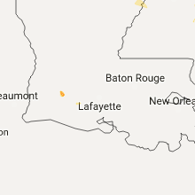
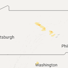
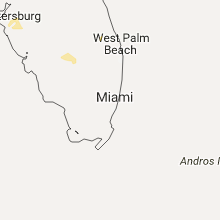
Hail Map for Sunday, July 31, 2016

Number of Impacted Households on 7/31/2016
0
Impacted by 1" or Larger Hail
0
Impacted by 1.75" or Larger Hail
0
Impacted by 2.5" or Larger Hail
Square Miles of Populated Area Impacted on 7/31/2016
0
Impacted by 1" or Larger Hail
0
Impacted by 1.75" or Larger Hail
0
Impacted by 2.5" or Larger Hail


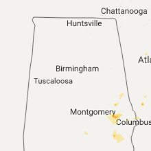


Cities Most Affected by Hail Storms of 7/31/2016
| Hail Size | Demographics of Zip Codes Affected | ||||||
|---|---|---|---|---|---|---|---|
| City | Count | Average | Largest | Pop Density | House Value | Income | Age |
| New Town, ND | 1 | 2.00 | 2.00 | 2 | $48k | $28.6k | 31.7 |
| Buffalo, SD | 1 | 1.75 | 1.75 | 0 | $50k | $25.3k | 43.2 |
Hail and Wind Damage Spotted on 7/31/2016
Filter by Report Type:Hail ReportsWind Reports
States Impacted
Nebraska, Georgia, North Carolina, Mississippi, South Carolina, Virginia, Florida, Oklahoma, North Dakota, South Dakota, Pennsylvania, Colorado, Montana, MissouriNebraska
| Local Time | Report Details |
|---|---|
| 9:12 AM CDT | 6-8 inch diameter tree branch downed in front of high schoo in butler county NE, 55.5 miles W of Omaha, NE |
Georgia
| Local Time | Report Details |
|---|---|
| 1:30 PM EDT | Shingles were blown off the roof of a house near the intersection of suggs mill road and georgia highway 137. a carport attached to the house was damaged. a camper acro in taylor county GA, 75.4 miles E of Auburn, AL |
| 2:00 PM EDT | A tree was blown down on manor stree in crawford county GA, 74.2 miles SSE of Atlanta, GA |
| 2:13 PM EDT | A tree was blown down on marshall mill r in crawford county GA, 79.8 miles SSE of Atlanta, GA |
| 2:16 PM EDT | Tree down on highway 41 south. time estimated based on rada in randolph county GA, 80.9 miles SE of Auburn, AL |
| 3:15 PM EDT | Tree down in dougherty county GA, 72.3 miles N of Tallahassee, FL |
| 3:20 PM EDT | Tree down on johnson rd. time estimated by rada in dougherty county GA, 72.7 miles W of Douglas, GA |
| 3:25 PM EDT | Tree dow in mitchell county GA, 67 miles N of Tallahassee, FL |
| 5:05 PM EDT | Sections of the roofs on two barns were blown off on hwy 57 near moores chapel. 6 trees were also blown down near this locatio in johnson county GA, 65.8 miles SW of Augusta, GA |
| 5:58 PM EDT | Two trees were downed on woodstock rd at sable trace lan in cherokee county GA, 27.3 miles NNW of Atlanta, GA |
North Carolina
| Local Time | Report Details |
|---|---|
| 2:42 PM EDT | A few trees and power lines down in north wilkesboro area. time radar estimate in wilkes county NC, 66.9 miles ESE of Bristol, TN |
| 3:00 PM EDT | Report of large tree down in roadway on hwy 133 near forest ln. time estimated by rada in pender county NC, 12.1 miles N of Wilmington, NC |
| 3:12 PM EDT | Couple of trees down over somers rd near 421. time radar estimate in wilkes county NC, 64.2 miles N of Charlotte, NC |
| 3:20 PM EDT | Reported a couple trees down blocking the wilkes yadkin hwy. time radar estimate in yadkin county NC, 63.3 miles N of Charlotte, NC |
| 3:30 PM EDT | A few trees reported down in the hamptonville area. time radar estimate in yadkin county NC, 61.9 miles N of Charlotte, NC |
| 3:45 PM EDT | Report of damage to several trees and tree limbs down on richard switch rd. time estimated by rada in pender county NC, 14.9 miles NNW of Wilmington, NC |
| 4:45 PM EDT | Report of damage to several trees and tree limbs down on richard switch rd. time estimated by rada in pender county NC, 14.9 miles NNW of Wilmington, NC |
| 8:12 PM EDT | Numerous trees down across oak grove church road and mebane oaks roa in orange county NC, 35.3 miles WNW of Raleigh, NC |
| 8:32 PM EDT | Spotter reported heavy rain and frequent lightning and trees down in yard in southern thomasvill in davidson county NC, 59.5 miles NE of Charlotte, NC |
| 8:45 PM EDT | 911 call center reported tree down across cunningham road southwest of thomasville in davidson county NC, 56.8 miles NE of Charlotte, NC |
| 8:47 PM EDT | 911 call center reported tree down across sullivan and carter roads south of thomasville in davidson county NC, 57.8 miles NE of Charlotte, NC |
| 8:47 PM EDT | 911 call center reported tree down across road at sullivan and cunningham south of thomasville in davidson county NC, 57.7 miles NE of Charlotte, NC |
| 1:10 AM EDT | The yadkin county 911 center reports that multiple power lines were down near the intersection of old u.s. highway 421 and baltimore road. old u.s. highway 421 had to b in yadkin county NC, 63.7 miles NNE of Charlotte, NC |
Mississippi
| Local Time | Report Details |
|---|---|
| 2:00 PM CDT | Tree down across old agency roa in madison county MS, 9.1 miles N of Jackson, MS |
| 4:27 PM CDT | Tree down near the intersection of hwy 61 and letourneau roa in warren county MS, 45.5 miles W of Jackson, MS |
| 4:45 PM CDT | Tree down along hwy 3 near international pape in warren county MS, 40.5 miles W of Jackson, MS |
South Carolina
| Local Time | Report Details |
|---|---|
| 3:34 PM EDT | Sce&g reports 539 outages due to limbs/trees on power lines in swansea and gaston area in lexington county SC, 54.6 miles ENE of Augusta, GA |
| 3:39 PM EDT | Quarter sized hail reported near Gaston, SC, 50.6 miles ENE of Augusta, GA, social media report of quarter sized hail along highway 6 southwest of gaston. time estimated by radar. |
| 5:05 PM EDT | Tree on power line water spring rd 1 mile from pasture lan in orangeburg county SC, 52.5 miles WNW of Charleston, SC |
Virginia
| Local Time | Report Details |
|---|---|
| 4:00 PM EDT | Tree down across gable farm rd at east colonial hwy in loudoun county VA, 56.3 miles W of Baltimore, MD |
| 4:02 PM EDT | Tree down in 17000 block bridge view ct in loudoun county VA, 54.7 miles W of Baltimore, MD |
| 5:18 PM EDT | Tree blocking loch haven dr. time radar estimate in roanoke county VA, 5.7 miles NW of Roanoke, VA |
| 5:35 PM EDT | Multiple trees down on patterson near 12th st blocking road. time radar estimate in city of roanoke county VA, 1.1 miles W of Roanoke, VA |
| 6:33 PM EDT | Two trees down on route 60 in buckingham county VA, 52.2 miles W of Richmond, VA |
| 9:05 PM EDT | Trees down on king william and black gum road. in king william county VA, 38.3 miles ENE of Richmond, VA |
| 9:17 PM EDT | Trees down on mantua roa in king and queen county VA, 41.8 miles ENE of Richmond, VA |
| 9:19 PM EDT | Trees down on anderson highway near the chesterfield county line. in powhatan county VA, 4.9 miles W of Richmond, VA |
Florida
| Local Time | Report Details |
|---|---|
| 5:05 PM EDT | Tree down on dover r in gadsden county FL, 12.6 miles NW of Tallahassee, FL |
| 7:42 PM EDT | Dispatch reported multiple trees down off of florida hwy 2 near the fl/ga borde in baker county FL, 36.7 miles WNW of Jacksonville, FL |
Oklahoma
| Local Time | Report Details |
|---|---|
| 4:41 PM CDT | Quarter sized hail reported near Sallisaw, OK, 21.4 miles WNW of Fort Smith, AR, mostly pea sized hail with a few quarter sized stones mixed in. relayed via social media. |
| 4:45 PM CDT | Large tree snapped. metal building damaged. damage located at sallisaw city park and highway 64. received via social medi in sequoyah county OK, 21.4 miles WNW of Fort Smith, AR |
| 5:20 PM CDT | Trees snapped by microburst winds. time estimated by rada in garvin county OK, 47 miles SSE of Oklahoma City, OK |
North Dakota
| Local Time | Report Details |
|---|---|
| 3:55 PM MDT | Quarter sized hail reported near Rhame, ND, 104.9 miles ESE of Miles City, MT |
| 6:05 PM CDT | Half Dollar sized hail reported near Ross, ND, 49.9 miles E of Williston, ND, . |
| 6:12 PM CDT | Quarter sized hail reported near Stanley, ND, 50.3 miles W of Minot, ND, hail ongoing at time of call. |
| 6:19 PM CDT | Quarter sized hail reported near Stanley, ND, 52.3 miles E of Williston, ND, hail ongoing at the time of call. |
| 6:30 PM CDT | Quarter sized hail reported near New Town, ND, 52.9 miles E of Williston, ND, . |
| 5:55 PM MDT | Quarter sized hail reported near Killdeer, ND, 56.9 miles SE of Williston, ND |
| 7:05 PM CDT | A report of a truck pulling a trailer and boat being blown to the guard rail on the bridge west of new town as well as the high winds in new tow in mountrail county ND, 53.7 miles ESE of Williston, ND |
| 7:06 PM CDT | 4 inch diameter branches were snapped of in mountrail county ND, 52.9 miles ESE of Williston, ND |
| 7:06 PM CDT | Metal roof singles damaged and water running into buildin in mountrail county ND, 53.7 miles ESE of Williston, ND |
| 7:18 PM CDT | Hen Egg sized hail reported near New Town, ND, 53.7 miles ESE of Williston, ND, . |
| 7:23 PM CDT | Ping Pong Ball sized hail reported near New Town, ND, 52.9 miles ESE of Williston, ND, ongoing at the time of call. |
| 7:25 PM CDT | Quarter sized hail reported near New Town, ND, 53.7 miles ESE of Williston, ND, . |
| 7:25 PM CDT | Storm damage reported in mountrail county ND, 53.7 miles ESE of Williston, ND |
| 7:41 PM CDT | Camper overturned in a ditch near the intersection of highways 8 and 2 in mountrail county ND, 51.4 miles WSW of Minot, ND |
| 7:45 PM CDT | Grain bin was blown into a wheat fiel in mountrail county ND, 50.8 miles ESE of Williston, ND |
South Dakota
| Local Time | Report Details |
|---|---|
| 4:05 PM MDT | Quarter sized hail reported near Buffalo, SD, 111.2 miles ESE of Miles City, MT |
| 4:33 PM MDT | Golf Ball sized hail reported near Buffalo, SD, 111.1 miles ESE of Miles City, MT |
| 5:17 PM MDT | Storm damage reported in harding county SD, 112.4 miles N of Rapid City, SD |
| 5:30 PM MDT | Storm damage reported in harding county SD, 108.1 miles N of Rapid City, SD |
| 6:06 PM MDT | Storm damage reported in harding county SD, 106 miles N of Rapid City, SD |
| 6:11 PM MDT | Quarter sized hail reported near Hill City, SD, 20.3 miles WSW of Rapid City, SD |
| 6:25 PM MDT | Storm damage reported in harding county SD, 104.7 miles N of Rapid City, SD |
| 6:32 PM MDT | Storm damage reported in harding county SD, 104.6 miles N of Rapid City, SD |
| 8:00 PM MDT | Storm damage reported in meade county SD, 66.7 miles NNE of Rapid City, SD |
| 8:30 PM MDT | Storm damage reported in meade county SD, 89.2 miles NE of Rapid City, SD |
| 8:55 PM MDT | Storm damage reported in perkins county SD, 77.1 miles NNE of Rapid City, SD |
| 9:10 PM MDT | Quarter sized hail reported near Faith, SD, 82.9 miles NNE of Rapid City, SD |
| 10:50 PM MDT | Storm damage reported in ziebach county SD, 71.6 miles ENE of Rapid City, SD |
| 1:20 AM MDT | Storm damage reported in haakon county SD, 44 miles WSW of Pierre, SD |
| 3:02 AM CDT | Storm damage reported in jones county SD, 39.4 miles SSW of Pierre, SD |
Pennsylvania
| Local Time | Report Details |
|---|---|
| 6:11 PM EDT | Trees and wires down in clinton county PA, 37.5 miles N of State College, PA |
| 6:15 PM EDT | Trees down in clinton county PA, 36.3 miles NNE of State College, PA |
| 7:40 PM EDT | Quarter sized hail reported near Loganton, PA, 37.8 miles ENE of State College, PA |
| 8:15 PM EDT | Trees down in union county PA, 47.7 miles ENE of State College, PA |
| 9:10 PM EDT | Trees and wides down on sunbury road. tree blocking roa in northumberland county PA, 60.9 miles WSW of Scranton, PA |
| 9:25 PM EDT | Trees down in northumberland county PA, 59.5 miles SW of Scranton, PA |
Colorado
| Local Time | Report Details |
|---|---|
| 6:58 PM MDT | From thunderstorm outflow. small trees bent ove in yuma county CO, 3.4 miles S of Yuma, CO |
Montana
| Local Time | Report Details |
|---|---|
| 7:00 PM MDT | Storm damage reported in yellowstone county MT, 1.8 miles ENE of Billings, MT |
Missouri
| Local Time | Report Details |
|---|---|
| 3:35 AM CDT | Tree down in miller county MO, 52.1 miles SSW of Columbia, MO |
Connect with Interactive Hail Maps