

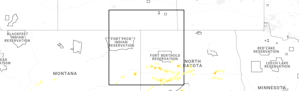
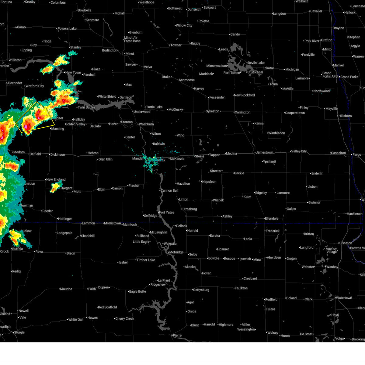
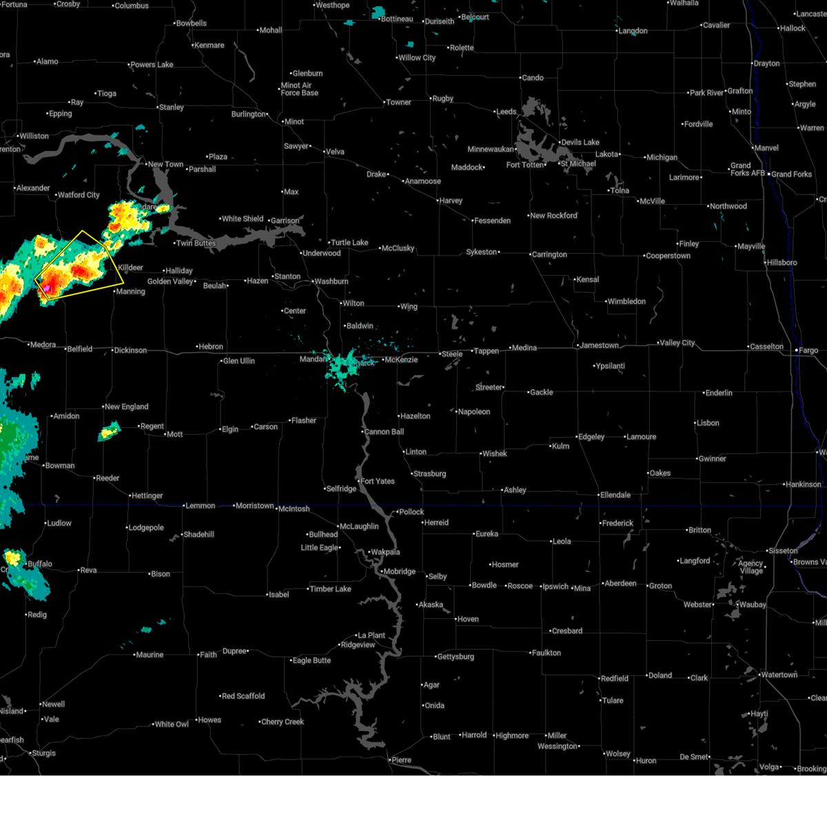
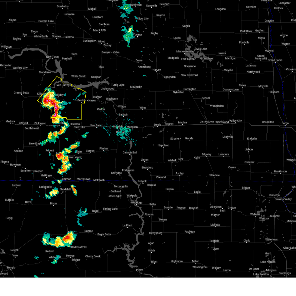
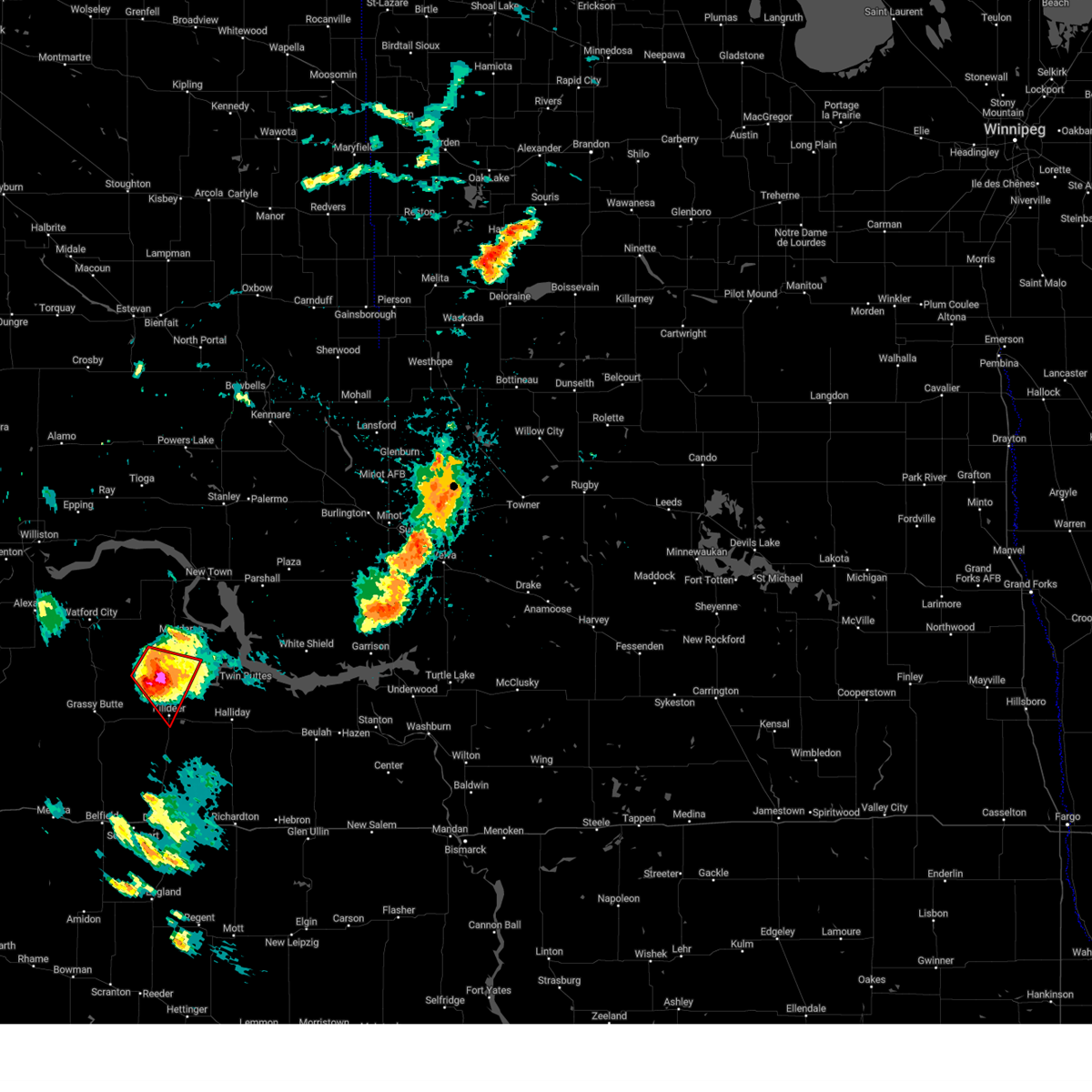
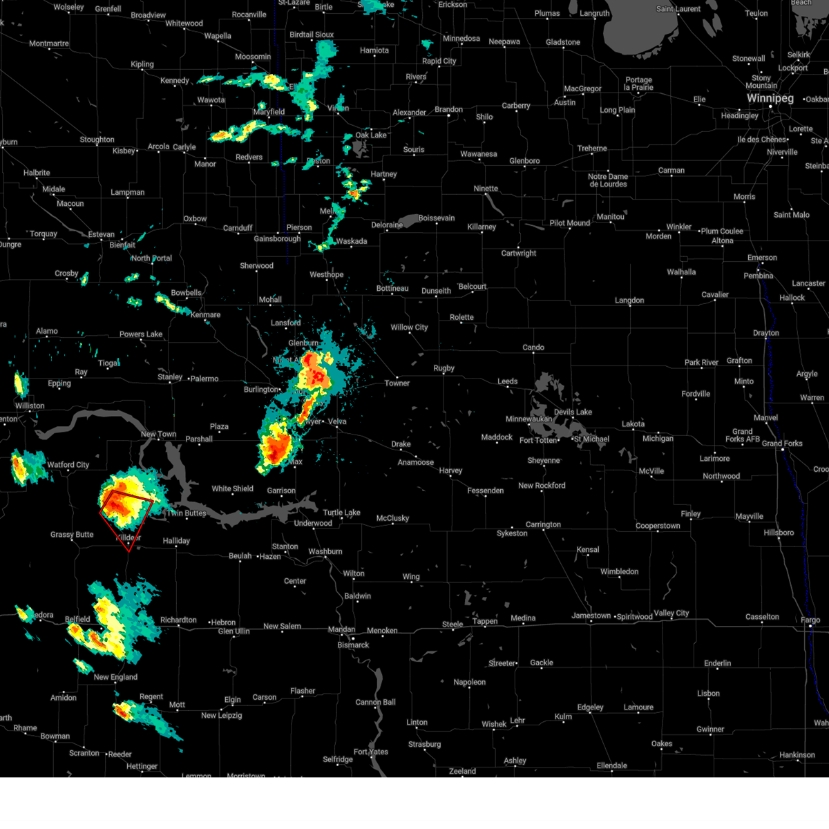
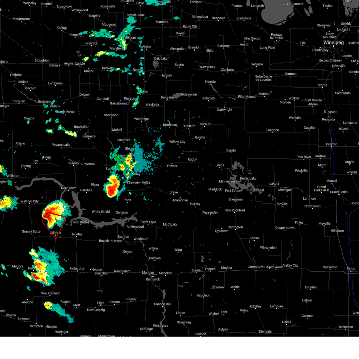
Hail Map for Killdeer, ND
The Killdeer, ND area has had 16 reports of on-the-ground hail by trained spotters, and has been under severe weather warnings 9 times during the past 12 months. Doppler radar has detected hail at or near Killdeer, ND on 45 occasions, including 4 occasions during the past year.
| Name: | Killdeer, ND |
| Where Located: | 67.3 miles SE of Williston, ND |
| Map: | Google Map for Killdeer, ND |
| Population: | 751 |
| Housing Units: | 342 |
| More Info: | Search Google for Killdeer, ND |
1
The Top Recent Hail Date for Killdeer, ND is Friday, June 20, 2025 (10th out of 45)
Hail and Wind Damage Spotted near Killdeer, ND
| Date / Time | Report Details |
|---|---|
| 6/20/2025 5:29 PM MDT |
 At 529 pm mdt, a severe thunderstorm was located 8 miles north of south fairfield, or 33 miles northwest of dickinson, moving east at 15 mph (radar indicated). Hazards include half dollar size hail. Damage to vehicles is expected. Locations impacted include, killdeer, grassy butte, and oakdale. At 529 pm mdt, a severe thunderstorm was located 8 miles north of south fairfield, or 33 miles northwest of dickinson, moving east at 15 mph (radar indicated). Hazards include half dollar size hail. Damage to vehicles is expected. Locations impacted include, killdeer, grassy butte, and oakdale.
|
| 6/20/2025 5:15 PM MDT |
 Svrbis the national weather service in bismarck has issued a * severe thunderstorm warning for, west central dunn county in southwestern north dakota, northeastern billings county in southwestern north dakota, south central mckenzie county in northwestern north dakota, * until 615 pm mdt. * at 515 pm mdt, a severe thunderstorm was located 9 miles south of grassy butte, or 36 miles northwest of dickinson, moving northeast at 25 mph (radar indicated). Hazards include quarter size hail. damage to vehicles is expected Svrbis the national weather service in bismarck has issued a * severe thunderstorm warning for, west central dunn county in southwestern north dakota, northeastern billings county in southwestern north dakota, south central mckenzie county in northwestern north dakota, * until 615 pm mdt. * at 515 pm mdt, a severe thunderstorm was located 9 miles south of grassy butte, or 36 miles northwest of dickinson, moving northeast at 25 mph (radar indicated). Hazards include quarter size hail. damage to vehicles is expected
|
| 7/30/2024 4:17 PM MDT |
 Svrbis the national weather service in bismarck has issued a * severe thunderstorm warning for, eastern dunn county in southwestern north dakota, mercer county in south central north dakota, * until 615 pm cdt. * at 517 pm cdt, severe thunderstorms were located along a line extending from 7 miles northeast of dunn center to 6 miles southwest of dodge to 4 miles northeast of taylor, moving east at 25 mph (radar indicated). Hazards include 60 mph wind gusts and penny size hail. expect damage to roofs, siding, and trees Svrbis the national weather service in bismarck has issued a * severe thunderstorm warning for, eastern dunn county in southwestern north dakota, mercer county in south central north dakota, * until 615 pm cdt. * at 517 pm cdt, severe thunderstorms were located along a line extending from 7 miles northeast of dunn center to 6 miles southwest of dodge to 4 miles northeast of taylor, moving east at 25 mph (radar indicated). Hazards include 60 mph wind gusts and penny size hail. expect damage to roofs, siding, and trees
|
| 7/12/2024 6:56 PM MDT |
 At 755 pm cdt, a severe thunderstorm was located near dunn center, or 34 miles north of dickinson, moving southeast at 25 mph (radar indicated). Hazards include golf ball size hail and 60 mph wind gusts. People and animals outdoors will be injured. expect hail damage to roofs, siding, windows, and vehicles. expect wind damage to roofs, siding, and trees. Locations impacted include, killdeer, halliday, dunn center, and little missouri state park. At 755 pm cdt, a severe thunderstorm was located near dunn center, or 34 miles north of dickinson, moving southeast at 25 mph (radar indicated). Hazards include golf ball size hail and 60 mph wind gusts. People and animals outdoors will be injured. expect hail damage to roofs, siding, windows, and vehicles. expect wind damage to roofs, siding, and trees. Locations impacted include, killdeer, halliday, dunn center, and little missouri state park.
|
| 7/12/2024 6:43 PM MDT |
 At 743 pm cdt, a severe thunderstorm was located near dunn center, or 37 miles north of dickinson, moving southeast at 25 mph (radar indicated). Hazards include tennis ball size hail and 60 mph wind gusts. People and animals outdoors will be injured. expect hail damage to roofs, siding, windows, and vehicles. expect wind damage to roofs, siding, and trees. Locations impacted include, killdeer, halliday, dunn center, oakdale, and little missouri state park. At 743 pm cdt, a severe thunderstorm was located near dunn center, or 37 miles north of dickinson, moving southeast at 25 mph (radar indicated). Hazards include tennis ball size hail and 60 mph wind gusts. People and animals outdoors will be injured. expect hail damage to roofs, siding, windows, and vehicles. expect wind damage to roofs, siding, and trees. Locations impacted include, killdeer, halliday, dunn center, oakdale, and little missouri state park.
|
| 7/12/2024 6:41 PM MDT | Tennis Ball sized hail reported 5 miles S of Killdeer, ND, report relayed via broadcast media. radar estimated time. |
| 7/12/2024 6:30 PM MDT | Baseball sized hail reported 9.6 miles SSE of Killdeer, ND, report relayed via broadcast media with radar estimated time. |
| 7/12/2024 6:29 PM MDT |
 The tornado threat has diminished and the tornado warning has been cancelled. however, large hail and damaging winds remain likely and a severe thunderstorm warning remains in effect for the area. a severe thunderstorm watch remains in effect until midnight cdt for southwestern north dakota. The tornado threat has diminished and the tornado warning has been cancelled. however, large hail and damaging winds remain likely and a severe thunderstorm warning remains in effect for the area. a severe thunderstorm watch remains in effect until midnight cdt for southwestern north dakota.
|
| 7/12/2024 6:28 PM MDT |
 Svrbis the national weather service in bismarck has issued a * severe thunderstorm warning for, central dunn county in southwestern north dakota, * until 830 pm cdt. * at 728 pm cdt, a severe thunderstorm was located 7 miles north of killdeer, or 33 miles southeast of watford city, moving southeast at 25 mph (radar indicated). Hazards include tennis ball size hail and 60 mph wind gusts. People and animals outdoors will be injured. expect hail damage to roofs, siding, windows, and vehicles. Expect wind damage to roofs, siding, and trees. Svrbis the national weather service in bismarck has issued a * severe thunderstorm warning for, central dunn county in southwestern north dakota, * until 830 pm cdt. * at 728 pm cdt, a severe thunderstorm was located 7 miles north of killdeer, or 33 miles southeast of watford city, moving southeast at 25 mph (radar indicated). Hazards include tennis ball size hail and 60 mph wind gusts. People and animals outdoors will be injured. expect hail damage to roofs, siding, windows, and vehicles. Expect wind damage to roofs, siding, and trees.
|
| 7/12/2024 6:24 PM MDT | Golf Ball sized hail reported 13.5 miles SSE of Killdeer, ND, report relayed via social media. radar estimated time. |
| 7/12/2024 6:20 PM MDT | Golf Ball sized hail reported 12.7 miles S of Killdeer, ND, hail ongoing at the time of the call. |
| 7/12/2024 6:13 PM MDT |
 At 712 pm cdt, a severe thunderstorm capable of producing a tornado was located 13 miles north of killdeer, or 26 miles southeast of watford city, moving southeast at 15 mph (radar indicated rotation). Hazards include tornado and ping pong ball size hail. Flying debris will be dangerous to those caught without shelter. mobile homes will be damaged or destroyed. damage to roofs, windows, and vehicles will occur. tree damage is likely. Locations impacted include, killdeer, oakdale, and little missouri state park. At 712 pm cdt, a severe thunderstorm capable of producing a tornado was located 13 miles north of killdeer, or 26 miles southeast of watford city, moving southeast at 15 mph (radar indicated rotation). Hazards include tornado and ping pong ball size hail. Flying debris will be dangerous to those caught without shelter. mobile homes will be damaged or destroyed. damage to roofs, windows, and vehicles will occur. tree damage is likely. Locations impacted include, killdeer, oakdale, and little missouri state park.
|
| 7/12/2024 6:03 PM MDT |
 Torbis the national weather service in bismarck has issued a * tornado warning for, northwestern dunn county in southwestern north dakota, * until 730 pm cdt. * at 703 pm cdt, a severe thunderstorm capable of producing a tornado was located 15 miles northwest of killdeer, or 23 miles southeast of watford city, moving southeast at 20 mph (radar indicated rotation). Hazards include tornado and ping pong ball size hail. Flying debris will be dangerous to those caught without shelter. mobile homes will be damaged or destroyed. damage to roofs, windows, and vehicles will occur. tree damage is likely. This tornadic thunderstorm will remain over mainly rural areas of northwestern dunn county, including the following locations, little missouri state park and oakdale. Torbis the national weather service in bismarck has issued a * tornado warning for, northwestern dunn county in southwestern north dakota, * until 730 pm cdt. * at 703 pm cdt, a severe thunderstorm capable of producing a tornado was located 15 miles northwest of killdeer, or 23 miles southeast of watford city, moving southeast at 20 mph (radar indicated rotation). Hazards include tornado and ping pong ball size hail. Flying debris will be dangerous to those caught without shelter. mobile homes will be damaged or destroyed. damage to roofs, windows, and vehicles will occur. tree damage is likely. This tornadic thunderstorm will remain over mainly rural areas of northwestern dunn county, including the following locations, little missouri state park and oakdale.
|
| 6/27/2024 8:36 PM CDT |
 The storms which prompted the warning have weakened below severe limits. therefore, the warning will be allowed to expire. a tornado watch remains in effect until 1000 pm cdt for southwestern and northwestern north dakota. a severe thunderstorm watch remains in effect until 200 am cdt for south central and northwestern north dakota. The storms which prompted the warning have weakened below severe limits. therefore, the warning will be allowed to expire. a tornado watch remains in effect until 1000 pm cdt for southwestern and northwestern north dakota. a severe thunderstorm watch remains in effect until 200 am cdt for south central and northwestern north dakota.
|
| 6/27/2024 8:11 PM CDT |
 At 810 pm cdt, severe thunderstorms were located along a line extending from 14 miles northeast of watford city to 7 miles west of mandaree to 5 miles north of dunn center, moving east at 45 mph (radar indicated). Hazards include 60 mph wind gusts and penny size hail. Expect damage to roofs, siding, and trees. Locations impacted include, watford city, new town, killdeer, halliday, dunn center, arnegard, mandaree, 4 bears lodge, mckenzie bay recreation area, four bears village, keene, white earth bay recreation area, pouch point recreation area, little missouri state park, oakdale, charlson, skunk creek bay recreation area, twin buttes, tobacco garden bay recreation area, and crow flies high state recreation area. At 810 pm cdt, severe thunderstorms were located along a line extending from 14 miles northeast of watford city to 7 miles west of mandaree to 5 miles north of dunn center, moving east at 45 mph (radar indicated). Hazards include 60 mph wind gusts and penny size hail. Expect damage to roofs, siding, and trees. Locations impacted include, watford city, new town, killdeer, halliday, dunn center, arnegard, mandaree, 4 bears lodge, mckenzie bay recreation area, four bears village, keene, white earth bay recreation area, pouch point recreation area, little missouri state park, oakdale, charlson, skunk creek bay recreation area, twin buttes, tobacco garden bay recreation area, and crow flies high state recreation area.
|
| 6/27/2024 7:40 PM CDT |
 Svrbis the national weather service in bismarck has issued a * severe thunderstorm warning for, northern dunn county in southwestern north dakota, central mckenzie county in northwestern north dakota, southwestern mountrail county in northwestern north dakota, * until 845 pm cdt. * at 740 pm cdt, severe thunderstorms were located along a line extending from near alexander to theodore roosevelt national park north unit to 9 miles southeast of grassy butte, moving northeast at 40 mph (radar indicated). Hazards include 60 mph wind gusts and quarter size hail. Hail damage to vehicles is expected. Expect wind damage to roofs, siding, and trees. Svrbis the national weather service in bismarck has issued a * severe thunderstorm warning for, northern dunn county in southwestern north dakota, central mckenzie county in northwestern north dakota, southwestern mountrail county in northwestern north dakota, * until 845 pm cdt. * at 740 pm cdt, severe thunderstorms were located along a line extending from near alexander to theodore roosevelt national park north unit to 9 miles southeast of grassy butte, moving northeast at 40 mph (radar indicated). Hazards include 60 mph wind gusts and quarter size hail. Hail damage to vehicles is expected. Expect wind damage to roofs, siding, and trees.
|
| 6/15/2024 11:36 PM CDT |
 At 1136 pm cdt, severe thunderstorms were located along a line extending from near new town to near killdeer, moving east at 45 mph (radar indicated). Hazards include 60 mph wind gusts and quarter size hail. Hail damage to vehicles is expected. expect wind damage to roofs, siding, and trees. Locations impacted include, parshall, killdeer, halliday, dunn center, mandaree, van hook park, mckenzie bay recreation area, keene, pouch point recreation area, little missouri state park, deep water creek recreation area, oakdale, skunk creek bay recreation area, twin buttes, parshall bay recreation area, johnsons corner, and fort berthold. At 1136 pm cdt, severe thunderstorms were located along a line extending from near new town to near killdeer, moving east at 45 mph (radar indicated). Hazards include 60 mph wind gusts and quarter size hail. Hail damage to vehicles is expected. expect wind damage to roofs, siding, and trees. Locations impacted include, parshall, killdeer, halliday, dunn center, mandaree, van hook park, mckenzie bay recreation area, keene, pouch point recreation area, little missouri state park, deep water creek recreation area, oakdale, skunk creek bay recreation area, twin buttes, parshall bay recreation area, johnsons corner, and fort berthold.
|
| 6/15/2024 11:15 PM CDT |
 Svrbis the national weather service in bismarck has issued a * severe thunderstorm warning for, northern dunn county in southwestern north dakota, northwestern mclean county in south central north dakota, southeastern mckenzie county in northwestern north dakota, southeastern mountrail county in northwestern north dakota, * until 1215 am cdt. * at 1114 pm cdt, severe thunderstorms were located along a line extending from 7 miles southwest of four bears village to 10 miles east of grassy butte, moving east at 35 mph (radar indicated). Hazards include 70 mph wind gusts and half dollar size hail. Hail damage to vehicles is expected. expect considerable tree damage. Wind damage is also likely to mobile homes, roofs, and outbuildings. Svrbis the national weather service in bismarck has issued a * severe thunderstorm warning for, northern dunn county in southwestern north dakota, northwestern mclean county in south central north dakota, southeastern mckenzie county in northwestern north dakota, southeastern mountrail county in northwestern north dakota, * until 1215 am cdt. * at 1114 pm cdt, severe thunderstorms were located along a line extending from 7 miles southwest of four bears village to 10 miles east of grassy butte, moving east at 35 mph (radar indicated). Hazards include 70 mph wind gusts and half dollar size hail. Hail damage to vehicles is expected. expect considerable tree damage. Wind damage is also likely to mobile homes, roofs, and outbuildings.
|
| 6/15/2024 11:00 PM CDT |
 At 1100 pm cdt, severe thunderstorms were located along a line extending from 14 miles northeast of watford city to near grassy butte, moving east at 40 mph (radar indicated). Hazards include 70 mph wind gusts and ping pong ball size hail. People and animals outdoors will be injured. expect hail damage to roofs, siding, windows, and vehicles. expect considerable tree damage. wind damage is also likely to mobile homes, roofs, and outbuildings. Locations impacted include, watford city, killdeer, alexander, arnegard, mandaree, theodore roosevelt national park north unit, grassy butte, keene, rawson, little missouri state park, oakdale, and johnsons corner. At 1100 pm cdt, severe thunderstorms were located along a line extending from 14 miles northeast of watford city to near grassy butte, moving east at 40 mph (radar indicated). Hazards include 70 mph wind gusts and ping pong ball size hail. People and animals outdoors will be injured. expect hail damage to roofs, siding, windows, and vehicles. expect considerable tree damage. wind damage is also likely to mobile homes, roofs, and outbuildings. Locations impacted include, watford city, killdeer, alexander, arnegard, mandaree, theodore roosevelt national park north unit, grassy butte, keene, rawson, little missouri state park, oakdale, and johnsons corner.
|
| 6/15/2024 10:44 PM CDT |
 At 1044 pm cdt, severe thunderstorms were located along a line extending from 6 miles northeast of watford city to 5 miles southwest of grassy butte, moving east at 40 mph (radar indicated). Hazards include 70 mph wind gusts and half dollar size hail. Hail damage to vehicles is expected. expect considerable tree damage. wind damage is also likely to mobile homes, roofs, and outbuildings. Locations impacted include, watford city, killdeer, alexander, arnegard, mandaree, grassy butte, theodore roosevelt national park north unit, keene, sather dam, charbonneau, little missouri state park, oakdale, rawson, and johnsons corner. At 1044 pm cdt, severe thunderstorms were located along a line extending from 6 miles northeast of watford city to 5 miles southwest of grassy butte, moving east at 40 mph (radar indicated). Hazards include 70 mph wind gusts and half dollar size hail. Hail damage to vehicles is expected. expect considerable tree damage. wind damage is also likely to mobile homes, roofs, and outbuildings. Locations impacted include, watford city, killdeer, alexander, arnegard, mandaree, grassy butte, theodore roosevelt national park north unit, keene, sather dam, charbonneau, little missouri state park, oakdale, rawson, and johnsons corner.
|
| 6/15/2024 10:22 PM CDT |
 Svrbis the national weather service in bismarck has issued a * severe thunderstorm warning for, northwestern dunn county in southwestern north dakota, mckenzie county in northwestern north dakota, * until 1115 pm cdt. * at 1022 pm cdt, severe thunderstorms were located along a line extending from near alexander to 13 miles east of trotters, moving east at 45 mph (radar indicated). Hazards include 70 mph wind gusts and ping pong ball size hail. People and animals outdoors will be injured. expect hail damage to roofs, siding, windows, and vehicles. expect considerable tree damage. Wind damage is also likely to mobile homes, roofs, and outbuildings. Svrbis the national weather service in bismarck has issued a * severe thunderstorm warning for, northwestern dunn county in southwestern north dakota, mckenzie county in northwestern north dakota, * until 1115 pm cdt. * at 1022 pm cdt, severe thunderstorms were located along a line extending from near alexander to 13 miles east of trotters, moving east at 45 mph (radar indicated). Hazards include 70 mph wind gusts and ping pong ball size hail. People and animals outdoors will be injured. expect hail damage to roofs, siding, windows, and vehicles. expect considerable tree damage. Wind damage is also likely to mobile homes, roofs, and outbuildings.
|
| 8/1/2023 7:01 PM MDT |
 At 701 pm mdt, severe thunderstorms were located along a line extending from near grassy butte to 8 miles north of south fairfield to 10 miles northeast of medora, moving east at 30 mph (radar indicated). Hazards include 70 mph wind gusts and quarter size hail. Hail damage to vehicles is expected. expect considerable tree damage. wind damage is also likely to mobile homes, roofs, and outbuildings. severe thunderstorms will be near, south fairfield around 705 pm mdt. manning around 740 pm mdt. killdeer around 750 pm mdt. dunn center around 800 pm mdt. taylor and marshall around 815 pm mdt. other locations impacted by these severe thunderstorms include hirschville, oakdale, fairfield and new hradec. thunderstorm damage threat, considerable hail threat, radar indicated max hail size, 1. 00 in wind threat, radar indicated max wind gust, 70 mph. At 701 pm mdt, severe thunderstorms were located along a line extending from near grassy butte to 8 miles north of south fairfield to 10 miles northeast of medora, moving east at 30 mph (radar indicated). Hazards include 70 mph wind gusts and quarter size hail. Hail damage to vehicles is expected. expect considerable tree damage. wind damage is also likely to mobile homes, roofs, and outbuildings. severe thunderstorms will be near, south fairfield around 705 pm mdt. manning around 740 pm mdt. killdeer around 750 pm mdt. dunn center around 800 pm mdt. taylor and marshall around 815 pm mdt. other locations impacted by these severe thunderstorms include hirschville, oakdale, fairfield and new hradec. thunderstorm damage threat, considerable hail threat, radar indicated max hail size, 1. 00 in wind threat, radar indicated max wind gust, 70 mph.
|
| 8/1/2023 7:00 PM MDT | Heavy rain... dime hai in dunn county ND, 0.3 miles SW of Killdeer, ND |
| 8/1/2023 6:46 PM MDT |
 At 746 pm cdt, a severe thunderstorm was located over dunn center, or 31 miles north of dickinson, moving southeast at 40 mph (radar indicated). Hazards include golf ball size hail and 70 mph wind gusts. People and animals outdoors will be injured. expect hail damage to roofs, siding, windows, and vehicles. expect considerable tree damage. wind damage is also likely to mobile homes, roofs, and outbuildings. this severe storm will be near, halliday around 700 pm mdt. other locations impacted by this severe thunderstorm include twin buttes. thunderstorm damage threat, considerable hail threat, observed max hail size, 1. 75 in wind threat, radar indicated max wind gust, 70 mph. At 746 pm cdt, a severe thunderstorm was located over dunn center, or 31 miles north of dickinson, moving southeast at 40 mph (radar indicated). Hazards include golf ball size hail and 70 mph wind gusts. People and animals outdoors will be injured. expect hail damage to roofs, siding, windows, and vehicles. expect considerable tree damage. wind damage is also likely to mobile homes, roofs, and outbuildings. this severe storm will be near, halliday around 700 pm mdt. other locations impacted by this severe thunderstorm include twin buttes. thunderstorm damage threat, considerable hail threat, observed max hail size, 1. 75 in wind threat, radar indicated max wind gust, 70 mph.
|
| 8/1/2023 6:30 PM MDT |
 At 730 pm cdt, a severe thunderstorm was located near killdeer, or 35 miles southeast of watford city, moving southeast at 35 mph (radar indicated). Hazards include golf ball size hail and 70 mph wind gusts. People and animals outdoors will be injured. expect hail damage to roofs, siding, windows, and vehicles. expect considerable tree damage. wind damage is also likely to mobile homes, roofs, and outbuildings. this severe storm will be near, killdeer around 635 pm mdt. dunn center around 645 pm mdt. other locations impacted by this severe thunderstorm include oakdale, twin buttes and little missouri state park. thunderstorm damage threat, considerable hail threat, observed max hail size, 1. 75 in wind threat, radar indicated max wind gust, 70 mph. At 730 pm cdt, a severe thunderstorm was located near killdeer, or 35 miles southeast of watford city, moving southeast at 35 mph (radar indicated). Hazards include golf ball size hail and 70 mph wind gusts. People and animals outdoors will be injured. expect hail damage to roofs, siding, windows, and vehicles. expect considerable tree damage. wind damage is also likely to mobile homes, roofs, and outbuildings. this severe storm will be near, killdeer around 635 pm mdt. dunn center around 645 pm mdt. other locations impacted by this severe thunderstorm include oakdale, twin buttes and little missouri state park. thunderstorm damage threat, considerable hail threat, observed max hail size, 1. 75 in wind threat, radar indicated max wind gust, 70 mph.
|
| 8/1/2023 6:09 PM MDT |
 At 708 pm cdt, a severe thunderstorm was located 13 miles southeast of theodore roosevelt national park north unit, or 23 miles southeast of watford city, moving southeast at 40 mph (radar indicated). Hazards include golf ball size hail and 60 mph wind gusts. People and animals outdoors will be injured. expect hail damage to roofs, siding, windows, and vehicles. expect wind damage to roofs, siding, and trees. this severe thunderstorm will be near, killdeer around 630 pm mdt. dunn center around 640 pm mdt. halliday around 655 pm mdt. other locations impacted by this severe thunderstorm include oakdale, twin buttes, little missouri state park and fort berthold. thunderstorm damage threat, considerable hail threat, observed max hail size, 1. 75 in wind threat, radar indicated max wind gust, 60 mph. At 708 pm cdt, a severe thunderstorm was located 13 miles southeast of theodore roosevelt national park north unit, or 23 miles southeast of watford city, moving southeast at 40 mph (radar indicated). Hazards include golf ball size hail and 60 mph wind gusts. People and animals outdoors will be injured. expect hail damage to roofs, siding, windows, and vehicles. expect wind damage to roofs, siding, and trees. this severe thunderstorm will be near, killdeer around 630 pm mdt. dunn center around 640 pm mdt. halliday around 655 pm mdt. other locations impacted by this severe thunderstorm include oakdale, twin buttes, little missouri state park and fort berthold. thunderstorm damage threat, considerable hail threat, observed max hail size, 1. 75 in wind threat, radar indicated max wind gust, 60 mph.
|
| 7/10/2022 2:15 AM MDT |
 At 314 am cdt/214 am mdt/, severe thunderstorms were located along a line extending from near little missouri state park to 7 miles southwest of halliday to 7 miles northwest of gladstone to 8 miles east of new england, moving east at 55 mph (radar indicated). Hazards include 70 mph wind gusts and quarter size hail. Hail damage to vehicles is expected. expect considerable tree damage. wind damage is also likely to mobile homes, roofs, and outbuildings. locations impacted include, dickinson, killdeer, new england, richardton, south heart, gladstone, halliday, taylor, dunn center, dodge, manning, marshall, little missouri state park, lefor, and schefield. thunderstorm damage threat, considerable hail threat, radar indicated max hail size, 1. 00 in wind threat, observed max wind gust, 70 mph. At 314 am cdt/214 am mdt/, severe thunderstorms were located along a line extending from near little missouri state park to 7 miles southwest of halliday to 7 miles northwest of gladstone to 8 miles east of new england, moving east at 55 mph (radar indicated). Hazards include 70 mph wind gusts and quarter size hail. Hail damage to vehicles is expected. expect considerable tree damage. wind damage is also likely to mobile homes, roofs, and outbuildings. locations impacted include, dickinson, killdeer, new england, richardton, south heart, gladstone, halliday, taylor, dunn center, dodge, manning, marshall, little missouri state park, lefor, and schefield. thunderstorm damage threat, considerable hail threat, radar indicated max hail size, 1. 00 in wind threat, observed max wind gust, 70 mph.
|
| 7/10/2022 2:12 AM MDT |
 At 211 am mdt, severe thunderstorms were located along a line extending from 5 miles south of little missouri state park to near dunn center to 11 miles northeast of dickinson, moving east at 60 mph. these are destructive storms for southwest dunn county (trained weather spotters). Hazards include 80 mph wind gusts and quarter size hail. Flying debris will be dangerous to those caught without shelter. mobile homes will be heavily damaged. expect considerable damage to roofs, windows, and vehicles. extensive tree damage and power outages are likely. these severe thunderstorms will remain over mainly rural areas of southwestern dunn and northeastern billings counties, including the following locations, hirschville, oakdale and new hradec. thunderstorm damage threat, destructive hail threat, radar indicated max hail size, 1. 00 in wind threat, observed max wind gust, 80 mph. At 211 am mdt, severe thunderstorms were located along a line extending from 5 miles south of little missouri state park to near dunn center to 11 miles northeast of dickinson, moving east at 60 mph. these are destructive storms for southwest dunn county (trained weather spotters). Hazards include 80 mph wind gusts and quarter size hail. Flying debris will be dangerous to those caught without shelter. mobile homes will be heavily damaged. expect considerable damage to roofs, windows, and vehicles. extensive tree damage and power outages are likely. these severe thunderstorms will remain over mainly rural areas of southwestern dunn and northeastern billings counties, including the following locations, hirschville, oakdale and new hradec. thunderstorm damage threat, destructive hail threat, radar indicated max hail size, 1. 00 in wind threat, observed max wind gust, 80 mph.
|
| 7/10/2022 2:02 AM MDT |
 At 300 am cdt/200 am mdt/, severe thunderstorms were located along a line extending from 7 miles east of grassy butte to 4 miles northeast of manning to 6 miles northwest of dickinson to 4 miles west of new england, moving east at 50 mph (radar indicated). Hazards include 70 mph wind gusts and half dollar size hail. Hail damage to vehicles is expected. expect considerable tree damage. wind damage is also likely to mobile homes, roofs, and outbuildings. these severe storms will be near, manning around 205 am mdt. dunn center around 210 am mdt. killdeer around 220 am mdt. halliday and taylor around 225 am mdt. dodge around 230 am mdt. marshall around 240 am mdt. other locations impacted by these severe thunderstorms include hirschville, schefield, oakdale, fairfield, havelock, lefor, new hradec and dickinson regional airport. thunderstorm damage threat, considerable hail threat, radar indicated max hail size, 1. 25 in wind threat, observed max wind gust, 70 mph. At 300 am cdt/200 am mdt/, severe thunderstorms were located along a line extending from 7 miles east of grassy butte to 4 miles northeast of manning to 6 miles northwest of dickinson to 4 miles west of new england, moving east at 50 mph (radar indicated). Hazards include 70 mph wind gusts and half dollar size hail. Hail damage to vehicles is expected. expect considerable tree damage. wind damage is also likely to mobile homes, roofs, and outbuildings. these severe storms will be near, manning around 205 am mdt. dunn center around 210 am mdt. killdeer around 220 am mdt. halliday and taylor around 225 am mdt. dodge around 230 am mdt. marshall around 240 am mdt. other locations impacted by these severe thunderstorms include hirschville, schefield, oakdale, fairfield, havelock, lefor, new hradec and dickinson regional airport. thunderstorm damage threat, considerable hail threat, radar indicated max hail size, 1. 25 in wind threat, observed max wind gust, 70 mph.
|
| 7/10/2022 1:57 AM MDT |
 At 156 am mdt, severe thunderstorms were located along a line extending from 5 miles east of grassy butte to 4 miles north of manning to 10 miles northwest of dickinson, moving east at 80 mph. these are destructive storms for northeast billings, south central mckenzie, and southwest dunn counties (trained weather spotters). Hazards include 80 mph wind gusts and quarter size hail. Flying debris will be dangerous to those caught without shelter. mobile homes will be heavily damaged. expect considerable damage to roofs, windows, and vehicles. extensive tree damage and power outages are likely. severe thunderstorms will be near, killdeer and manning around 200 am mdt. dunn center around 205 am mdt. little missouri state park around 215 am mdt. other locations impacted by these severe thunderstorms include hirschville, oakdale, fairfield, and new hradec. thunderstorm damage threat, destructive hail threat, radar indicated max hail size, 1. 00 in wind threat, observed max wind gust, 80 mph. At 156 am mdt, severe thunderstorms were located along a line extending from 5 miles east of grassy butte to 4 miles north of manning to 10 miles northwest of dickinson, moving east at 80 mph. these are destructive storms for northeast billings, south central mckenzie, and southwest dunn counties (trained weather spotters). Hazards include 80 mph wind gusts and quarter size hail. Flying debris will be dangerous to those caught without shelter. mobile homes will be heavily damaged. expect considerable damage to roofs, windows, and vehicles. extensive tree damage and power outages are likely. severe thunderstorms will be near, killdeer and manning around 200 am mdt. dunn center around 205 am mdt. little missouri state park around 215 am mdt. other locations impacted by these severe thunderstorms include hirschville, oakdale, fairfield, and new hradec. thunderstorm damage threat, destructive hail threat, radar indicated max hail size, 1. 00 in wind threat, observed max wind gust, 80 mph.
|
| 7/10/2022 1:42 AM MDT |
 At 242 am cdt/142 am mdt/, severe thunderstorms were located along a line extending from 9 miles southwest of grassy butte to 6 miles southeast of south fairfield to near amidon, moving east at 55 mph (radar indicated). Hazards include 70 mph wind gusts and half dollar size hail. Hail damage to vehicles is expected. expect considerable tree damage. wind damage is also likely to mobile homes, roofs, and outbuildings. severe thunderstorms will be near, new england around 205 am mdt. killdeer around 220 am mdt. dunn center and marshall around 225 am mdt. halliday around 240 am mdt. dodge around 245 am mdt. other locations impacted by these severe thunderstorms include fryburg, hirschville, schefield, oakdale, fairfield, havelock, lefor, new hradec, and dickinson. thunderstorm damage threat, considerable hail threat, radar indicated max hail size, 1. 25 in wind threat, observed max wind gust, 70 mph. At 242 am cdt/142 am mdt/, severe thunderstorms were located along a line extending from 9 miles southwest of grassy butte to 6 miles southeast of south fairfield to near amidon, moving east at 55 mph (radar indicated). Hazards include 70 mph wind gusts and half dollar size hail. Hail damage to vehicles is expected. expect considerable tree damage. wind damage is also likely to mobile homes, roofs, and outbuildings. severe thunderstorms will be near, new england around 205 am mdt. killdeer around 220 am mdt. dunn center and marshall around 225 am mdt. halliday around 240 am mdt. dodge around 245 am mdt. other locations impacted by these severe thunderstorms include fryburg, hirschville, schefield, oakdale, fairfield, havelock, lefor, new hradec, and dickinson. thunderstorm damage threat, considerable hail threat, radar indicated max hail size, 1. 25 in wind threat, observed max wind gust, 70 mph.
|
| 7/8/2021 6:48 PM MDT |
 At 748 pm cdt/648 pm mdt/, severe thunderstorms were located along a line extending from 5 miles northeast of mandaree to near little missouri state park to 10 miles east of grassy butte, moving east at 35 mph (radar indicated). Hazards include 60 mph wind gusts. Expect damage to roofs, siding, and trees. these severe storms will be near, killdeer around 710 pm mdt. dunn center around 720 pm mdt. Other locations impacted by these severe thunderstorms include oakdale, skunk creek bay recreation area and pouch point recreation area. At 748 pm cdt/648 pm mdt/, severe thunderstorms were located along a line extending from 5 miles northeast of mandaree to near little missouri state park to 10 miles east of grassy butte, moving east at 35 mph (radar indicated). Hazards include 60 mph wind gusts. Expect damage to roofs, siding, and trees. these severe storms will be near, killdeer around 710 pm mdt. dunn center around 720 pm mdt. Other locations impacted by these severe thunderstorms include oakdale, skunk creek bay recreation area and pouch point recreation area.
|
| 7/8/2021 6:28 PM MDT |
 At 728 pm cdt/628 pm mdt/, severe thunderstorms were located along a line extending from 10 miles northwest of mandaree to 7 miles west of little missouri state park to 5 miles north of grassy butte, moving east at 40 mph (radar indicated). Hazards include 60 mph wind gusts and quarter size hail. Hail damage to vehicles is expected. expect wind damage to roofs, siding, and trees. these severe storms will be near, mandaree around 740 pm cdt. little missouri state park around 640 pm mdt. killdeer around 705 pm mdt. dunn center around 710 pm mdt. Other locations impacted by these severe thunderstorms include oakdale, skunk creek bay recreation area, johnsons corner, and pouch point recreation area. At 728 pm cdt/628 pm mdt/, severe thunderstorms were located along a line extending from 10 miles northwest of mandaree to 7 miles west of little missouri state park to 5 miles north of grassy butte, moving east at 40 mph (radar indicated). Hazards include 60 mph wind gusts and quarter size hail. Hail damage to vehicles is expected. expect wind damage to roofs, siding, and trees. these severe storms will be near, mandaree around 740 pm cdt. little missouri state park around 640 pm mdt. killdeer around 705 pm mdt. dunn center around 710 pm mdt. Other locations impacted by these severe thunderstorms include oakdale, skunk creek bay recreation area, johnsons corner, and pouch point recreation area.
|
| 7/8/2021 6:14 PM MDT |
 At 714 pm cdt/614 pm mdt/, severe thunderstorms were located along a line extending from 14 miles northeast of watford city to 9 miles southwest of theodore roosevelt national park north unit, moving east at 40 mph (radar indicated). Hazards include 60 mph wind gusts and quarter size hail. Hail damage to vehicles is expected. expect wind damage to roofs, siding, and trees. severe thunderstorms will be near, grassy butte around 630 pm mdt. little missouri state park around 635 pm mdt. mandaree around 740 pm cdt. killdeer around 700 pm mdt. dunn center around 710 pm mdt. Other locations impacted by these severe thunderstorms include oakdale, skunk creek bay recreation area, rawson, johnsons corner, and pouch point recreation area. At 714 pm cdt/614 pm mdt/, severe thunderstorms were located along a line extending from 14 miles northeast of watford city to 9 miles southwest of theodore roosevelt national park north unit, moving east at 40 mph (radar indicated). Hazards include 60 mph wind gusts and quarter size hail. Hail damage to vehicles is expected. expect wind damage to roofs, siding, and trees. severe thunderstorms will be near, grassy butte around 630 pm mdt. little missouri state park around 635 pm mdt. mandaree around 740 pm cdt. killdeer around 700 pm mdt. dunn center around 710 pm mdt. Other locations impacted by these severe thunderstorms include oakdale, skunk creek bay recreation area, rawson, johnsons corner, and pouch point recreation area.
|
| 6/5/2021 10:38 PM MDT |
 At 1138 pm cdt/1038 pm mdt/, severe thunderstorms were located along a line extending from 5 miles northwest of mckenzie bay recreation area to 7 miles southwest of marshall, moving northeast at 50 mph (radar indicated). Hazards include 60 mph wind gusts. Expect damage to roofs, siding, and trees. Locations impacted include, killdeer, halliday, dunn center, dodge, manning, marshall, mckenzie bay recreation area, little missouri state park, skunk creek bay recreation area, twin buttes, hirschville, and oakdale. At 1138 pm cdt/1038 pm mdt/, severe thunderstorms were located along a line extending from 5 miles northwest of mckenzie bay recreation area to 7 miles southwest of marshall, moving northeast at 50 mph (radar indicated). Hazards include 60 mph wind gusts. Expect damage to roofs, siding, and trees. Locations impacted include, killdeer, halliday, dunn center, dodge, manning, marshall, mckenzie bay recreation area, little missouri state park, skunk creek bay recreation area, twin buttes, hirschville, and oakdale.
|
| 6/5/2021 10:25 PM MDT |
 At 1124 pm cdt/1024 pm mdt/, severe thunderstorms were located along a line extending from 8 miles northwest of mckenzie bay recreation area to marshall to 14 miles south of gladstone, moving east at 60 mph (surface observations). Hazards include 60 mph wind gusts and penny size hail. Expect damage to roofs, siding, and trees. Locations impacted include, dickinson, killdeer, richardton, south heart, gladstone, halliday, taylor, dunn center, dodge, manning, marshall, little missouri state park, mckenzie bay recreation area, hirschville, oakdale, lefor, new hradec, skunk creek bay recreation area, and twin buttes. At 1124 pm cdt/1024 pm mdt/, severe thunderstorms were located along a line extending from 8 miles northwest of mckenzie bay recreation area to marshall to 14 miles south of gladstone, moving east at 60 mph (surface observations). Hazards include 60 mph wind gusts and penny size hail. Expect damage to roofs, siding, and trees. Locations impacted include, dickinson, killdeer, richardton, south heart, gladstone, halliday, taylor, dunn center, dodge, manning, marshall, little missouri state park, mckenzie bay recreation area, hirschville, oakdale, lefor, new hradec, skunk creek bay recreation area, and twin buttes.
|
| 6/5/2021 10:11 PM MDT |
 At 1110 pm cdt/1010 pm mdt/, severe thunderstorms were located along a line extending from 5 miles north of little missouri state park to 8 miles northeast of new england, moving east at 45 mph (surface observations). Hazards include 60 mph wind gusts and penny size hail. expect damage to roofs, siding, and trees At 1110 pm cdt/1010 pm mdt/, severe thunderstorms were located along a line extending from 5 miles north of little missouri state park to 8 miles northeast of new england, moving east at 45 mph (surface observations). Hazards include 60 mph wind gusts and penny size hail. expect damage to roofs, siding, and trees
|
| 8/11/2020 7:38 PM MDT |
 At 838 pm cdt/738 pm mdt/, severe thunderstorms were located along a line extending from 11 miles south of parshall to 7 miles northeast of dickinson, moving east at 30 mph (radar indicated). Hazards include 70 mph wind gusts and quarter size hail. Hail damage to vehicles is expected. expect considerable tree damage. wind damage is also likely to mobile homes, roofs, and outbuildings. these severe storms will be near, roseglen around 905 pm cdt. Other locations impacted by these severe thunderstorms include skunk creek bay recreation area, white shield, twin buttes, pouch point recreation area, hirschville, deep water creek recreation area, dakota waters recreation area, raub, emmet and new hradec. At 838 pm cdt/738 pm mdt/, severe thunderstorms were located along a line extending from 11 miles south of parshall to 7 miles northeast of dickinson, moving east at 30 mph (radar indicated). Hazards include 70 mph wind gusts and quarter size hail. Hail damage to vehicles is expected. expect considerable tree damage. wind damage is also likely to mobile homes, roofs, and outbuildings. these severe storms will be near, roseglen around 905 pm cdt. Other locations impacted by these severe thunderstorms include skunk creek bay recreation area, white shield, twin buttes, pouch point recreation area, hirschville, deep water creek recreation area, dakota waters recreation area, raub, emmet and new hradec.
|
| 8/11/2020 7:19 PM MDT |
 At 818 pm cdt/718 pm mdt/, severe thunderstorms were located along a line extending from 10 miles south of van hook park to 8 miles north of south heart, moving east at 30 mph (radar indicated). Hazards include 70 mph wind gusts and quarter size hail. Hail damage to vehicles is expected. expect considerable tree damage. wind damage is also likely to mobile homes, roofs, and outbuildings. severe thunderstorms will be near, roseglen around 905 pm cdt. Other locations impacted by these severe thunderstorms include skunk creek bay recreation area, white shield, twin buttes, pouch point recreation area, hirschville, deep water creek recreation area, dakota waters recreation area, oakdale, raub and emmet. At 818 pm cdt/718 pm mdt/, severe thunderstorms were located along a line extending from 10 miles south of van hook park to 8 miles north of south heart, moving east at 30 mph (radar indicated). Hazards include 70 mph wind gusts and quarter size hail. Hail damage to vehicles is expected. expect considerable tree damage. wind damage is also likely to mobile homes, roofs, and outbuildings. severe thunderstorms will be near, roseglen around 905 pm cdt. Other locations impacted by these severe thunderstorms include skunk creek bay recreation area, white shield, twin buttes, pouch point recreation area, hirschville, deep water creek recreation area, dakota waters recreation area, oakdale, raub and emmet.
|
| 7/13/2020 12:24 AM MDT |
 The severe thunderstorm warning for southwestern dunn, northeastern billings and north central stark counties will expire at 1230 am mdt, the storm which prompted the warning has weakened below severe limits, and no longer poses an immediate threat to life or property. therefore, the warning will be allowed to expire. however heavy rain is still possible with this thunderstorm. to report severe weather, contact your nearest law enforcement agency. they will relay your report to the national weather service bismarck. The severe thunderstorm warning for southwestern dunn, northeastern billings and north central stark counties will expire at 1230 am mdt, the storm which prompted the warning has weakened below severe limits, and no longer poses an immediate threat to life or property. therefore, the warning will be allowed to expire. however heavy rain is still possible with this thunderstorm. to report severe weather, contact your nearest law enforcement agency. they will relay your report to the national weather service bismarck.
|
| 7/13/2020 12:08 AM MDT |
 At 1208 am mdt, a severe thunderstorm was located near manning, or 9 miles south of killdeer, moving northeast at 30 mph (radar indicated). Hazards include 60 mph wind gusts and quarter size hail. Hail damage to vehicles is expected. expect wind damage to roofs, siding, and trees. Locations impacted include, killdeer, taylor, dunn center, manning and hirschville. At 1208 am mdt, a severe thunderstorm was located near manning, or 9 miles south of killdeer, moving northeast at 30 mph (radar indicated). Hazards include 60 mph wind gusts and quarter size hail. Hail damage to vehicles is expected. expect wind damage to roofs, siding, and trees. Locations impacted include, killdeer, taylor, dunn center, manning and hirschville.
|
| 7/12/2020 11:41 PM MDT |
 At 1140 pm mdt, a severe thunderstorm was located 7 miles southwest of manning, or 16 miles south of killdeer, moving east at 30 mph (radar indicated). Hazards include ping pong ball size hail and 60 mph wind gusts. People and animals outdoors will be injured. expect hail damage to roofs, siding, windows, and vehicles. expect wind damage to roofs, siding, and trees. Locations impacted include, killdeer, taylor, dunn center, manning, hirschville and new hradec. At 1140 pm mdt, a severe thunderstorm was located 7 miles southwest of manning, or 16 miles south of killdeer, moving east at 30 mph (radar indicated). Hazards include ping pong ball size hail and 60 mph wind gusts. People and animals outdoors will be injured. expect hail damage to roofs, siding, windows, and vehicles. expect wind damage to roofs, siding, and trees. Locations impacted include, killdeer, taylor, dunn center, manning, hirschville and new hradec.
|
| 7/12/2020 11:24 PM MDT |
 At 1123 pm mdt, a severe thunderstorm was located near south fairfield, or 21 miles northwest of dickinson, moving east at 30 mph (radar indicated). Hazards include golf ball size hail and 60 mph wind gusts. People and animals outdoors will be injured. expect hail damage to roofs, siding, windows, and vehicles. Expect wind damage to roofs, siding, and trees. At 1123 pm mdt, a severe thunderstorm was located near south fairfield, or 21 miles northwest of dickinson, moving east at 30 mph (radar indicated). Hazards include golf ball size hail and 60 mph wind gusts. People and animals outdoors will be injured. expect hail damage to roofs, siding, windows, and vehicles. Expect wind damage to roofs, siding, and trees.
|
| 7/7/2020 8:59 PM MDT |
 At 934 pm cdt/834 pm mdt/, severe thunderstorms were located along a line extending from 12 miles north of skaar to 8 miles northeast of beach, moving east at 40 mph (radar indicated). Hazards include 60 mph wind gusts and penny size hail. expect damage to roofs, siding, and trees At 934 pm cdt/834 pm mdt/, severe thunderstorms were located along a line extending from 12 miles north of skaar to 8 miles northeast of beach, moving east at 40 mph (radar indicated). Hazards include 60 mph wind gusts and penny size hail. expect damage to roofs, siding, and trees
|
| 7/7/2020 8:34 PM MDT |
 At 934 pm cdt/834 pm mdt/, severe thunderstorms were located along a line extending from 12 miles north of skaar to 8 miles northeast of beach, moving east at 40 mph (radar indicated). Hazards include 60 mph wind gusts and penny size hail. expect damage to roofs, siding, and trees At 934 pm cdt/834 pm mdt/, severe thunderstorms were located along a line extending from 12 miles north of skaar to 8 miles northeast of beach, moving east at 40 mph (radar indicated). Hazards include 60 mph wind gusts and penny size hail. expect damage to roofs, siding, and trees
|
| 6/29/2020 8:49 PM CDT |
 At 849 pm cdt/749 pm mdt/, severe thunderstorms were located along a line extending from 8 miles northeast of mandaree to 10 miles northwest of taylor, moving northeast at 10 mph (radar indicated). Hazards include 60 mph wind gusts and quarter size hail. Hail damage to vehicles is expected. expect wind damage to roofs, siding, and trees. Locations impacted include, killdeer, halliday, dunn center, manning, mckenzie bay recreation area, little missouri state park, skunk creek bay recreation area and hirschville. At 849 pm cdt/749 pm mdt/, severe thunderstorms were located along a line extending from 8 miles northeast of mandaree to 10 miles northwest of taylor, moving northeast at 10 mph (radar indicated). Hazards include 60 mph wind gusts and quarter size hail. Hail damage to vehicles is expected. expect wind damage to roofs, siding, and trees. Locations impacted include, killdeer, halliday, dunn center, manning, mckenzie bay recreation area, little missouri state park, skunk creek bay recreation area and hirschville.
|
| 6/29/2020 8:29 PM CDT |
 At 829 pm cdt/729 pm mdt/, severe thunderstorms were located along a line extending from 4 miles northeast of mandaree to 9 miles north of gladstone, moving northeast at 10 mph (radar indicated). Hazards include 60 mph wind gusts and quarter size hail. Hail damage to vehicles is expected. expect wind damage to roofs, siding, and trees. These severe thunderstorms will remain over mainly rural areas of dunn county, including the following locations, hirschville, oakdale, skunk creek bay recreation area and new hradec. At 829 pm cdt/729 pm mdt/, severe thunderstorms were located along a line extending from 4 miles northeast of mandaree to 9 miles north of gladstone, moving northeast at 10 mph (radar indicated). Hazards include 60 mph wind gusts and quarter size hail. Hail damage to vehicles is expected. expect wind damage to roofs, siding, and trees. These severe thunderstorms will remain over mainly rural areas of dunn county, including the following locations, hirschville, oakdale, skunk creek bay recreation area and new hradec.
|
| 6/29/2020 7:08 PM MDT |
 At 808 pm cdt/708 pm mdt/, severe thunderstorms were located along a line extending from near mandaree to 6 miles northeast of killdeer to 9 miles southeast of manning, moving northeast at 20 mph (radar indicated). Hazards include golf ball size hail and 70 mph wind gusts. People and animals outdoors will be injured. expect hail damage to roofs, siding, windows, and vehicles. expect considerable tree damage. wind damage is also likely to mobile homes, roofs, and outbuildings. these severe storms will be near, little missouri state park around 720 pm mdt. Other locations impacted by these severe thunderstorms include hirschville, oakdale and new hradec. At 808 pm cdt/708 pm mdt/, severe thunderstorms were located along a line extending from near mandaree to 6 miles northeast of killdeer to 9 miles southeast of manning, moving northeast at 20 mph (radar indicated). Hazards include golf ball size hail and 70 mph wind gusts. People and animals outdoors will be injured. expect hail damage to roofs, siding, windows, and vehicles. expect considerable tree damage. wind damage is also likely to mobile homes, roofs, and outbuildings. these severe storms will be near, little missouri state park around 720 pm mdt. Other locations impacted by these severe thunderstorms include hirschville, oakdale and new hradec.
|
| 6/29/2020 6:51 PM MDT |
 At 750 pm cdt/650 pm mdt/, severe thunderstorms were located along a line extending from 9 miles west of mandaree to 11 miles north of dickinson, moving north at 10 mph (radar indicated). Hazards include golf ball size hail and 70 mph wind gusts. People and animals outdoors will be injured. expect hail damage to roofs, siding, windows, and vehicles. expect considerable tree damage. Wind damage is also likely to mobile homes, roofs, and outbuildings. At 750 pm cdt/650 pm mdt/, severe thunderstorms were located along a line extending from 9 miles west of mandaree to 11 miles north of dickinson, moving north at 10 mph (radar indicated). Hazards include golf ball size hail and 70 mph wind gusts. People and animals outdoors will be injured. expect hail damage to roofs, siding, windows, and vehicles. expect considerable tree damage. Wind damage is also likely to mobile homes, roofs, and outbuildings.
|
| 6/29/2020 7:44 PM CDT |
 At 744 pm cdt/644 pm mdt/, a severe thunderstorm was located 5 miles southwest of little missouri state park, or 11 miles northwest of killdeer, moving north at 35 mph (radar indicated). Hazards include golf ball size hail and 60 mph wind gusts. People and animals outdoors will be injured. expect hail damage to roofs, siding, windows, and vehicles. expect wind damage to roofs, siding, and trees. This severe thunderstorm will remain over mainly rural areas of northwestern dunn and east central mckenzie counties, including the following locations, oakdale. At 744 pm cdt/644 pm mdt/, a severe thunderstorm was located 5 miles southwest of little missouri state park, or 11 miles northwest of killdeer, moving north at 35 mph (radar indicated). Hazards include golf ball size hail and 60 mph wind gusts. People and animals outdoors will be injured. expect hail damage to roofs, siding, windows, and vehicles. expect wind damage to roofs, siding, and trees. This severe thunderstorm will remain over mainly rural areas of northwestern dunn and east central mckenzie counties, including the following locations, oakdale.
|
| 6/29/2020 6:32 PM MDT | Ndawn station 9nw medicine hol in dunn county ND, 17.3 miles SE of Killdeer, ND |
| 6/29/2020 7:25 PM CDT |
 At 724 pm cdt/624 pm mdt/, a severe thunderstorm was located over little missouri state park, or 13 miles north of killdeer, moving north at 35 mph (trained weather spotters). Hazards include golf ball size hail and 60 mph wind gusts. People and animals outdoors will be injured. expect hail damage to roofs, siding, windows, and vehicles. expect wind damage to roofs, siding, and trees. this severe storm will be near, mandaree around 740 pm cdt. Other locations impacted by this severe thunderstorm include oakdale. At 724 pm cdt/624 pm mdt/, a severe thunderstorm was located over little missouri state park, or 13 miles north of killdeer, moving north at 35 mph (trained weather spotters). Hazards include golf ball size hail and 60 mph wind gusts. People and animals outdoors will be injured. expect hail damage to roofs, siding, windows, and vehicles. expect wind damage to roofs, siding, and trees. this severe storm will be near, mandaree around 740 pm cdt. Other locations impacted by this severe thunderstorm include oakdale.
|
| 6/29/2020 7:07 PM CDT |
 At 707 pm cdt/607 pm mdt/, a severe thunderstorm was located over killdeer, moving north at 30 mph (trained weather spotters). Hazards include golf ball size hail and 60 mph wind gusts. People and animals outdoors will be injured. expect hail damage to roofs, siding, windows, and vehicles. expect wind damage to roofs, siding, and trees. this severe thunderstorm will be near, little missouri state park around 630 pm mdt. mandaree around 755 pm cdt. Other locations impacted by this severe thunderstorm include oakdale. At 707 pm cdt/607 pm mdt/, a severe thunderstorm was located over killdeer, moving north at 30 mph (trained weather spotters). Hazards include golf ball size hail and 60 mph wind gusts. People and animals outdoors will be injured. expect hail damage to roofs, siding, windows, and vehicles. expect wind damage to roofs, siding, and trees. this severe thunderstorm will be near, little missouri state park around 630 pm mdt. mandaree around 755 pm cdt. Other locations impacted by this severe thunderstorm include oakdale.
|
| 6/29/2020 6:05 PM MDT | Golf Ball sized hail reported 0.3 miles SW of Killdeer, ND, hail ongoing at time of call. |
| 6/29/2020 6:10 AM MDT | Golf Ball sized hail reported 0.3 miles ESE of Killdeer, ND, posted on twitter around 630 this morning. |
| 6/14/2020 6:49 PM MDT |
 At 748 pm cdt/648 pm mdt/, a severe thunderstorm was located 7 miles northwest of killdeer, moving northeast at 40 mph (radar indicated). Hazards include 60 mph wind gusts and half dollar size hail. Hail damage to vehicles is expected. expect wind damage to roofs, siding, and trees. this severe thunderstorm will be near, little missouri state park around 705 pm mdt. mandaree around 820 pm cdt. Other locations impacted by this severe thunderstorm include oakdale, johnsons corner and skunk creek bay recreation area. At 748 pm cdt/648 pm mdt/, a severe thunderstorm was located 7 miles northwest of killdeer, moving northeast at 40 mph (radar indicated). Hazards include 60 mph wind gusts and half dollar size hail. Hail damage to vehicles is expected. expect wind damage to roofs, siding, and trees. this severe thunderstorm will be near, little missouri state park around 705 pm mdt. mandaree around 820 pm cdt. Other locations impacted by this severe thunderstorm include oakdale, johnsons corner and skunk creek bay recreation area.
|
| 6/14/2020 6:32 PM MDT |
 At 631 pm mdt, a severe thunderstorm was located 10 miles west of manning, or 16 miles southwest of killdeer, moving northeast at 40 mph (radar indicated). Hazards include two inch hail and 70 mph wind gusts. People and animals outdoors will be injured. expect hail damage to roofs, siding, windows, and vehicles. expect considerable tree damage. wind damage is also likely to mobile homes, roofs, and outbuildings. this severe storm will be near, manning around 645 pm mdt. killdeer around 655 pm mdt. dunn center around 705 pm mdt. Other locations impacted by this severe thunderstorm include fairfield. At 631 pm mdt, a severe thunderstorm was located 10 miles west of manning, or 16 miles southwest of killdeer, moving northeast at 40 mph (radar indicated). Hazards include two inch hail and 70 mph wind gusts. People and animals outdoors will be injured. expect hail damage to roofs, siding, windows, and vehicles. expect considerable tree damage. wind damage is also likely to mobile homes, roofs, and outbuildings. this severe storm will be near, manning around 645 pm mdt. killdeer around 655 pm mdt. dunn center around 705 pm mdt. Other locations impacted by this severe thunderstorm include fairfield.
|
| 6/14/2020 6:14 PM MDT |
 At 613 pm mdt, a severe thunderstorm was located over south fairfield, or 24 miles northwest of dickinson, moving northeast at 30 mph (radar indicated). Hazards include two inch hail and 70 mph wind gusts. People and animals outdoors will be injured. expect hail damage to roofs, siding, windows, and vehicles. expect considerable tree damage. wind damage is also likely to mobile homes, roofs, and outbuildings. this severe thunderstorm will be near, manning around 650 pm mdt. killdeer around 705 pm mdt. dunn center around 710 pm mdt. Other locations impacted by this severe thunderstorm include hirschville and fairfield. At 613 pm mdt, a severe thunderstorm was located over south fairfield, or 24 miles northwest of dickinson, moving northeast at 30 mph (radar indicated). Hazards include two inch hail and 70 mph wind gusts. People and animals outdoors will be injured. expect hail damage to roofs, siding, windows, and vehicles. expect considerable tree damage. wind damage is also likely to mobile homes, roofs, and outbuildings. this severe thunderstorm will be near, manning around 650 pm mdt. killdeer around 705 pm mdt. dunn center around 710 pm mdt. Other locations impacted by this severe thunderstorm include hirschville and fairfield.
|
| 8/4/2019 11:47 PM CDT |
 At 1147 pm cdt/1047 pm mdt/, a severe thunderstorm was located over little missouri state park, or 12 miles north of killdeer, moving northeast at 30 mph (radar indicated). Hazards include ping pong ball size hail and 60 mph wind gusts. People and animals outdoors will be injured. expect hail damage to roofs, siding, windows, and vehicles. expect wind damage to roofs, siding, and trees. this severe storm will be near, mckenzie bay recreation area around 1220 am cdt. Other locations impacted by this severe thunderstorm include twin buttes, oakdale and skunk creek bay recreation area. At 1147 pm cdt/1047 pm mdt/, a severe thunderstorm was located over little missouri state park, or 12 miles north of killdeer, moving northeast at 30 mph (radar indicated). Hazards include ping pong ball size hail and 60 mph wind gusts. People and animals outdoors will be injured. expect hail damage to roofs, siding, windows, and vehicles. expect wind damage to roofs, siding, and trees. this severe storm will be near, mckenzie bay recreation area around 1220 am cdt. Other locations impacted by this severe thunderstorm include twin buttes, oakdale and skunk creek bay recreation area.
|
| 8/4/2019 11:38 PM CDT |
 At 1138 pm cdt/1038 pm mdt/, a severe thunderstorm was located 6 miles southwest of little missouri state park, or 11 miles northwest of killdeer, moving northeast at 30 mph (radar indicated). Hazards include ping pong ball size hail and 60 mph wind gusts. People and animals outdoors will be injured. expect hail damage to roofs, siding, windows, and vehicles. expect wind damage to roofs, siding, and trees. this severe thunderstorm will be near, little missouri state park around 1050 pm mdt. mckenzie bay recreation area around 1220 am cdt. Other locations impacted by this severe thunderstorm include twin buttes, oakdale and skunk creek bay recreation area. At 1138 pm cdt/1038 pm mdt/, a severe thunderstorm was located 6 miles southwest of little missouri state park, or 11 miles northwest of killdeer, moving northeast at 30 mph (radar indicated). Hazards include ping pong ball size hail and 60 mph wind gusts. People and animals outdoors will be injured. expect hail damage to roofs, siding, windows, and vehicles. expect wind damage to roofs, siding, and trees. this severe thunderstorm will be near, little missouri state park around 1050 pm mdt. mckenzie bay recreation area around 1220 am cdt. Other locations impacted by this severe thunderstorm include twin buttes, oakdale and skunk creek bay recreation area.
|
| 8/1/2019 3:56 PM CDT |
 At 355 pm cdt/255 pm mdt/, severe thunderstorms were located along a line extending from 7 miles northwest of mandaree to 5 miles north of killdeer, moving east at 20 mph (radar indicated). Hazards include 60 mph wind gusts and half dollar size hail. Hail damage to vehicles is expected. expect wind damage to roofs, siding, and trees. severe thunderstorms will be near, dunn center and mandaree around 410 pm cdt. halliday around 455 pm cdt. Other locations impacted by these severe thunderstorms include skunk creek bay recreation area, parshall bay recreation area, twin buttes and pouch point recreation area. At 355 pm cdt/255 pm mdt/, severe thunderstorms were located along a line extending from 7 miles northwest of mandaree to 5 miles north of killdeer, moving east at 20 mph (radar indicated). Hazards include 60 mph wind gusts and half dollar size hail. Hail damage to vehicles is expected. expect wind damage to roofs, siding, and trees. severe thunderstorms will be near, dunn center and mandaree around 410 pm cdt. halliday around 455 pm cdt. Other locations impacted by these severe thunderstorms include skunk creek bay recreation area, parshall bay recreation area, twin buttes and pouch point recreation area.
|
| 7/15/2019 12:19 AM MDT |
 At 117 am cdt/1217 am mdt/, severe thunderstorms were located along a line extending from 8 miles southeast of mandaree to 9 miles south of regent, moving east at 55 mph. these are very dangerous storms (radar indicated. also, a 77 mph wind gust was measured at the dickinson airport). Hazards include 80 mph wind gusts. Flying debris will be dangerous to those caught without shelter. mobile homes will be heavily damaged. expect considerable damage to roofs, windows, and vehicles. extensive tree damage and power outages are likely. Locations impacted include, dickinson, killdeer, mott, amidon, belfield, new england, richardton, south heart, gladstone, halliday, regent, taylor, dunn center, dodge, manning, marshall, grassy butte, south fairfield, little missouri state park and mckenzie bay recreation area. At 117 am cdt/1217 am mdt/, severe thunderstorms were located along a line extending from 8 miles southeast of mandaree to 9 miles south of regent, moving east at 55 mph. these are very dangerous storms (radar indicated. also, a 77 mph wind gust was measured at the dickinson airport). Hazards include 80 mph wind gusts. Flying debris will be dangerous to those caught without shelter. mobile homes will be heavily damaged. expect considerable damage to roofs, windows, and vehicles. extensive tree damage and power outages are likely. Locations impacted include, dickinson, killdeer, mott, amidon, belfield, new england, richardton, south heart, gladstone, halliday, regent, taylor, dunn center, dodge, manning, marshall, grassy butte, south fairfield, little missouri state park and mckenzie bay recreation area.
|
| 7/15/2019 12:12 AM MDT |
 At 111 am cdt/1211 am mdt/, severe thunderstorms were located along a line extending from 7 miles northwest of little missouri state park to 12 miles north of reeder, moving east at 50 mph (radar indicated). Hazards include 70 mph wind gusts. Expect considerable tree damage. damage is likely to mobile homes, roofs, and outbuildings. severe thunderstorms will be near, little missouri state park around 1220 am mdt. mckenzie bay recreation area around 1240 am mdt. mott around 1250 am mdt. Other locations impacted by these severe thunderstorms include fryburg, twin buttes, hirschville, schefield, burt, oakdale, fairfield, havelock, bentley and lefor. At 111 am cdt/1211 am mdt/, severe thunderstorms were located along a line extending from 7 miles northwest of little missouri state park to 12 miles north of reeder, moving east at 50 mph (radar indicated). Hazards include 70 mph wind gusts. Expect considerable tree damage. damage is likely to mobile homes, roofs, and outbuildings. severe thunderstorms will be near, little missouri state park around 1220 am mdt. mckenzie bay recreation area around 1240 am mdt. mott around 1250 am mdt. Other locations impacted by these severe thunderstorms include fryburg, twin buttes, hirschville, schefield, burt, oakdale, fairfield, havelock, bentley and lefor.
|
| 9/3/2018 6:58 PM MDT |
 At 657 pm mdt, a severe thunderstorm was located 7 miles north of south heart, or 13 miles northwest of dickinson, moving northeast at 25 mph (radar indicated). Hazards include 70 mph wind gusts and ping pong ball size hail. People and animals outdoors will be injured. expect hail damage to roofs, siding, windows, and vehicles. expect considerable tree damage. wind damage is also likely to mobile homes, roofs, and outbuildings. this severe thunderstorm will be near, manning around 755 pm mdt. killdeer around 800 pm mdt. Other locations impacted by this severe thunderstorm include new hradec. At 657 pm mdt, a severe thunderstorm was located 7 miles north of south heart, or 13 miles northwest of dickinson, moving northeast at 25 mph (radar indicated). Hazards include 70 mph wind gusts and ping pong ball size hail. People and animals outdoors will be injured. expect hail damage to roofs, siding, windows, and vehicles. expect considerable tree damage. wind damage is also likely to mobile homes, roofs, and outbuildings. this severe thunderstorm will be near, manning around 755 pm mdt. killdeer around 800 pm mdt. Other locations impacted by this severe thunderstorm include new hradec.
|
| 9/3/2018 6:44 PM MDT |
 At 743 pm cdt/643 pm mdt/, a cluster of severe thunderstorms were located along a line extending from 8 miles northeast of south fairfield to 6 miles east of little missouri state park, moving northeast at 20 mph (radar indicated). Hazards include golf ball size hail and 60 mph wind gusts. People and animals outdoors will be injured. expect hail damage to roofs, siding, windows, and vehicles. expect wind damage to roofs, siding, and trees. Locations impacted include, killdeer, little missouri state park and oakdale. At 743 pm cdt/643 pm mdt/, a cluster of severe thunderstorms were located along a line extending from 8 miles northeast of south fairfield to 6 miles east of little missouri state park, moving northeast at 20 mph (radar indicated). Hazards include golf ball size hail and 60 mph wind gusts. People and animals outdoors will be injured. expect hail damage to roofs, siding, windows, and vehicles. expect wind damage to roofs, siding, and trees. Locations impacted include, killdeer, little missouri state park and oakdale.
|
| 9/3/2018 6:40 PM MDT |
 At 739 pm cdt/639 pm mdt/, a cluster of severe thunderstorms were located along a line extending from 7 miles north of south fairfield to 5 miles east of little missouri state park, moving northeast at 20 mph (radar indicated). Hazards include 60 mph wind gusts and half dollar size hail. Hail damage to vehicles is expected. expect wind damage to roofs, siding, and trees. Locations impacted include, killdeer, little missouri state park and oakdale. At 739 pm cdt/639 pm mdt/, a cluster of severe thunderstorms were located along a line extending from 7 miles north of south fairfield to 5 miles east of little missouri state park, moving northeast at 20 mph (radar indicated). Hazards include 60 mph wind gusts and half dollar size hail. Hail damage to vehicles is expected. expect wind damage to roofs, siding, and trees. Locations impacted include, killdeer, little missouri state park and oakdale.
|
| 9/3/2018 6:25 PM MDT |
 At 716 pm cdt/616 pm mdt/, a cluster of severe thunderstorms was located 9 miles southeast of grassy butte, or 19 miles west of killdeer, moving northeast at 15 mph (radar indicated). Hazards include 60 mph wind gusts and quarter size hail. Hail damage to vehicles is expected. expect wind damage to roofs, siding, and trees. This severe thunderstorm will remain over mainly rural areas of northern dunn and northeastern billings counties, including the following locations, oakdale. At 716 pm cdt/616 pm mdt/, a cluster of severe thunderstorms was located 9 miles southeast of grassy butte, or 19 miles west of killdeer, moving northeast at 15 mph (radar indicated). Hazards include 60 mph wind gusts and quarter size hail. Hail damage to vehicles is expected. expect wind damage to roofs, siding, and trees. This severe thunderstorm will remain over mainly rural areas of northern dunn and northeastern billings counties, including the following locations, oakdale.
|
| 9/3/2018 6:16 PM MDT |
 At 716 pm cdt/616 pm mdt/, a cluster of severe thunderstorms was located 9 miles southeast of grassy butte, or 19 miles west of killdeer, moving northeast at 15 mph (radar indicated). Hazards include 60 mph wind gusts and quarter size hail. Hail damage to vehicles is expected. expect wind damage to roofs, siding, and trees. This severe thunderstorm will remain over mainly rural areas of northern dunn and northeastern billings counties, including the following locations, oakdale. At 716 pm cdt/616 pm mdt/, a cluster of severe thunderstorms was located 9 miles southeast of grassy butte, or 19 miles west of killdeer, moving northeast at 15 mph (radar indicated). Hazards include 60 mph wind gusts and quarter size hail. Hail damage to vehicles is expected. expect wind damage to roofs, siding, and trees. This severe thunderstorm will remain over mainly rural areas of northern dunn and northeastern billings counties, including the following locations, oakdale.
|
| 7/21/2018 7:32 PM MDT |
 At 731 pm mdt, a severe thunderstorm was located near manning, or 13 miles south of killdeer, moving southeast at 35 mph (66 mph wind gust was reported just south of manning). Hazards include 60 mph wind gusts and quarter size hail. Hail damage to vehicles is expected. expect wind damage to roofs, siding, and trees. This severe thunderstorm will remain over mainly rural areas of southwestern dunn and east central billings counties, including the following locations, hirschville and new hradec. At 731 pm mdt, a severe thunderstorm was located near manning, or 13 miles south of killdeer, moving southeast at 35 mph (66 mph wind gust was reported just south of manning). Hazards include 60 mph wind gusts and quarter size hail. Hail damage to vehicles is expected. expect wind damage to roofs, siding, and trees. This severe thunderstorm will remain over mainly rural areas of southwestern dunn and east central billings counties, including the following locations, hirschville and new hradec.
|
| 7/21/2018 7:16 PM MDT |
 At 716 pm mdt, a severe thunderstorm was located over manning, or 7 miles south of killdeer, moving southeast at 35 mph (radar indicated). Hazards include 60 mph wind gusts and quarter size hail. Hail damage to vehicles is expected. expect wind damage to roofs, siding, and trees. this severe storm will be near, manning around 720 pm mdt. Other locations impacted by this severe thunderstorm include hirschville, new hradec and fairfield. At 716 pm mdt, a severe thunderstorm was located over manning, or 7 miles south of killdeer, moving southeast at 35 mph (radar indicated). Hazards include 60 mph wind gusts and quarter size hail. Hail damage to vehicles is expected. expect wind damage to roofs, siding, and trees. this severe storm will be near, manning around 720 pm mdt. Other locations impacted by this severe thunderstorm include hirschville, new hradec and fairfield.
|
| 7/21/2018 6:56 PM MDT |
 At 755 pm cdt/655 pm mdt/, a severe thunderstorm was located 11 miles west of killdeer, moving southeast at 35 mph (radar indicated). Hazards include 70 mph wind gusts and ping pong ball size hail. People and animals outdoors will be injured. expect hail damage to roofs, siding, windows, and vehicles. expect considerable tree damage. wind damage is also likely to mobile homes, roofs, and outbuildings. this severe thunderstorm will be near, killdeer around 710 pm mdt. manning around 725 pm mdt. Other locations impacted by this severe thunderstorm include hirschville, oakdale, fairfield and new hradec. At 755 pm cdt/655 pm mdt/, a severe thunderstorm was located 11 miles west of killdeer, moving southeast at 35 mph (radar indicated). Hazards include 70 mph wind gusts and ping pong ball size hail. People and animals outdoors will be injured. expect hail damage to roofs, siding, windows, and vehicles. expect considerable tree damage. wind damage is also likely to mobile homes, roofs, and outbuildings. this severe thunderstorm will be near, killdeer around 710 pm mdt. manning around 725 pm mdt. Other locations impacted by this severe thunderstorm include hirschville, oakdale, fairfield and new hradec.
|
| 7/21/2018 6:47 PM MDT |
 At 747 pm cdt/647 pm mdt/, severe thunderstorms were located along a line extending from 8 miles east of theodore roosevelt national park north unit to 4 miles east of grassy butte to near skaar, moving southeast at 35 mph (radar indicated). Hazards include 70 mph wind gusts and ping pong ball size hail. People and animals outdoors will be injured. expect hail damage to roofs, siding, windows, and vehicles. expect considerable tree damage. wind damage is also likely to mobile homes, roofs, and outbuildings. these severe storms will be near, grassy butte around 655 pm mdt. Other locations impacted by these severe thunderstorms include oakdale. At 747 pm cdt/647 pm mdt/, severe thunderstorms were located along a line extending from 8 miles east of theodore roosevelt national park north unit to 4 miles east of grassy butte to near skaar, moving southeast at 35 mph (radar indicated). Hazards include 70 mph wind gusts and ping pong ball size hail. People and animals outdoors will be injured. expect hail damage to roofs, siding, windows, and vehicles. expect considerable tree damage. wind damage is also likely to mobile homes, roofs, and outbuildings. these severe storms will be near, grassy butte around 655 pm mdt. Other locations impacted by these severe thunderstorms include oakdale.
|
| 7/21/2018 7:29 PM CDT |
 At 729 pm cdt/629 pm mdt/, severe thunderstorms were located along a line extending from 13 miles east of watford city to near theodore roosevelt national park north unit to 5 miles northeast of trotters, moving southeast at 35 mph (trained weather spotters). Hazards include golf ball size hail and 70 mph wind gusts. People and animals outdoors will be injured. expect hail damage to roofs, siding, windows, and vehicles. expect considerable tree damage. wind damage is also likely to mobile homes, roofs, and outbuildings. these severe storms will be near, grassy butte around 645 pm mdt. mandaree around 700 pm mdt. Other locations impacted by these severe thunderstorms include oakdale and johnsons corner. At 729 pm cdt/629 pm mdt/, severe thunderstorms were located along a line extending from 13 miles east of watford city to near theodore roosevelt national park north unit to 5 miles northeast of trotters, moving southeast at 35 mph (trained weather spotters). Hazards include golf ball size hail and 70 mph wind gusts. People and animals outdoors will be injured. expect hail damage to roofs, siding, windows, and vehicles. expect considerable tree damage. wind damage is also likely to mobile homes, roofs, and outbuildings. these severe storms will be near, grassy butte around 645 pm mdt. mandaree around 700 pm mdt. Other locations impacted by these severe thunderstorms include oakdale and johnsons corner.
|
| 7/21/2018 7:19 PM CDT |
 At 719 pm cdt/619 pm mdt/, severe thunderstorms were located along a line extending from 14 miles west of 4 bears lodge to near theodore roosevelt national park north unit to 9 miles northeast of skaar, moving southeast at 40 mph (trained weather spotters reported golf ball size hail north of watford city ). Hazards include golf ball size hail and 70 mph wind gusts. People and animals outdoors will be injured. expect hail damage to roofs, siding, windows, and vehicles. expect considerable tree damage. wind damage is also likely to mobile homes, roofs, and outbuildings. these severe storms will be near, theodore roosevelt national park north unit around 725 pm cdt. grassy butte around 640 pm mdt. mandaree around 650 pm mdt. little missouri state park around 700 pm mdt. Other locations impacted by these severe thunderstorms include white tail bay recreation area, sather dam, keene, rawson, tobacco garden bay recreation area, oakdale, charlson and johnsons corner. At 719 pm cdt/619 pm mdt/, severe thunderstorms were located along a line extending from 14 miles west of 4 bears lodge to near theodore roosevelt national park north unit to 9 miles northeast of skaar, moving southeast at 40 mph (trained weather spotters reported golf ball size hail north of watford city ). Hazards include golf ball size hail and 70 mph wind gusts. People and animals outdoors will be injured. expect hail damage to roofs, siding, windows, and vehicles. expect considerable tree damage. wind damage is also likely to mobile homes, roofs, and outbuildings. these severe storms will be near, theodore roosevelt national park north unit around 725 pm cdt. grassy butte around 640 pm mdt. mandaree around 650 pm mdt. little missouri state park around 700 pm mdt. Other locations impacted by these severe thunderstorms include white tail bay recreation area, sather dam, keene, rawson, tobacco garden bay recreation area, oakdale, charlson and johnsons corner.
|
| 7/21/2018 6:56 PM CDT |
 At 655 pm cdt/555 pm mdt/, severe thunderstorms were located along a line extending from 19 miles south of ray to near arnegard to 11 miles northeast of skaar, moving southeast at 35 mph. these are very dangerous storms (radar indicated). Hazards include 80 mph wind gusts and two inch hail. Flying debris will be dangerous to those caught without shelter. mobile homes will be heavily damaged. expect considerable damage to roofs, windows, and vehicles. extensive tree damage and power outages are likely. severe thunderstorms will be near, theodore roosevelt national park north unit around 625 pm mdt. grassy butte around 645 pm mdt. mandaree around 650 pm mdt. Other locations impacted by these severe thunderstorms include white tail bay recreation area, sather dam, cartwright, keene, lewis and clark state park, charbonneau, rawson, tobacco garden bay recreation area, oakdale and charlson. At 655 pm cdt/555 pm mdt/, severe thunderstorms were located along a line extending from 19 miles south of ray to near arnegard to 11 miles northeast of skaar, moving southeast at 35 mph. these are very dangerous storms (radar indicated). Hazards include 80 mph wind gusts and two inch hail. Flying debris will be dangerous to those caught without shelter. mobile homes will be heavily damaged. expect considerable damage to roofs, windows, and vehicles. extensive tree damage and power outages are likely. severe thunderstorms will be near, theodore roosevelt national park north unit around 625 pm mdt. grassy butte around 645 pm mdt. mandaree around 650 pm mdt. Other locations impacted by these severe thunderstorms include white tail bay recreation area, sather dam, cartwright, keene, lewis and clark state park, charbonneau, rawson, tobacco garden bay recreation area, oakdale and charlson.
|
| 7/10/2018 2:19 AM CDT |
 A severe thunderstorm warning remains in effect until 230 am cdt/130 am mdt/ for central dunn and western mclean counties. at 219 am cdt/119 am mdt/, severe thunderstorms were located along a line extending from 5 miles south of roseglen to near halliday to 11 miles east of grassy butte, moving southeast at 30 mph. hazard. 60 mph wind gusts and quarter size hail. A severe thunderstorm warning remains in effect until 230 am cdt/130 am mdt/ for central dunn and western mclean counties. at 219 am cdt/119 am mdt/, severe thunderstorms were located along a line extending from 5 miles south of roseglen to near halliday to 11 miles east of grassy butte, moving southeast at 30 mph. hazard. 60 mph wind gusts and quarter size hail.
|
| 7/10/2018 1:54 AM CDT |
 At 152 am cdt/1252 am mdt/, severe thunderstorms were located along a line extending from 6 miles northeast of mandaree to 5 miles north of dunn center to 4 miles north of grassy butte, moving southeast at 35 mph (radar indicated). Hazards include 70 mph wind gusts and ping pong ball size hail. People and animals outdoors will be injured. expect hail damage to roofs, siding, windows, and vehicles. expect considerable tree damage. wind damage is also likely to mobile homes, roofs, and outbuildings. these severe storms will be near, killdeer around 1255 am mdt. dunn center around 100 am mdt. mckenzie bay recreation area around 115 am mdt. halliday around 120 am mdt. Other locations impacted by these severe thunderstorms include deep water creek recreation area, oakdale, skunk creek bay recreation area and twin buttes. At 152 am cdt/1252 am mdt/, severe thunderstorms were located along a line extending from 6 miles northeast of mandaree to 5 miles north of dunn center to 4 miles north of grassy butte, moving southeast at 35 mph (radar indicated). Hazards include 70 mph wind gusts and ping pong ball size hail. People and animals outdoors will be injured. expect hail damage to roofs, siding, windows, and vehicles. expect considerable tree damage. wind damage is also likely to mobile homes, roofs, and outbuildings. these severe storms will be near, killdeer around 1255 am mdt. dunn center around 100 am mdt. mckenzie bay recreation area around 115 am mdt. halliday around 120 am mdt. Other locations impacted by these severe thunderstorms include deep water creek recreation area, oakdale, skunk creek bay recreation area and twin buttes.
|
| 7/10/2018 12:37 AM MDT |
 At 137 am cdt/1237 am mdt/, severe thunderstorms were located along a line extending from 8 miles southwest of 4 bears lodge to 4 miles south of little missouri state park to 8 miles southwest of theodore roosevelt national park north unit, moving southeast at 30 mph (public. extensive wind damage was reported in watford city). Hazards include golf ball size hail and 70 mph wind gusts. People and animals outdoors will be injured. expect hail damage to roofs, siding, windows, and vehicles. expect considerable tree damage. wind damage is also likely to mobile homes, roofs, and outbuildings. severe thunderstorms will be near, little missouri state park around 1240 am mdt. killdeer around 1250 am mdt. dunn center around 100 am mdt. halliday around 120 am mdt. Other locations impacted by these severe thunderstorms include deep water creek recreation area, oakdale, skunk creek bay recreation area, twin buttes and pouch point recreation area. At 137 am cdt/1237 am mdt/, severe thunderstorms were located along a line extending from 8 miles southwest of 4 bears lodge to 4 miles south of little missouri state park to 8 miles southwest of theodore roosevelt national park north unit, moving southeast at 30 mph (public. extensive wind damage was reported in watford city). Hazards include golf ball size hail and 70 mph wind gusts. People and animals outdoors will be injured. expect hail damage to roofs, siding, windows, and vehicles. expect considerable tree damage. wind damage is also likely to mobile homes, roofs, and outbuildings. severe thunderstorms will be near, little missouri state park around 1240 am mdt. killdeer around 1250 am mdt. dunn center around 100 am mdt. halliday around 120 am mdt. Other locations impacted by these severe thunderstorms include deep water creek recreation area, oakdale, skunk creek bay recreation area, twin buttes and pouch point recreation area.
|
| 6/28/2018 10:40 PM MDT |
 The severe thunderstorm warning for dunn, northwestern mclean, northeastern billings, east central mckenzie, south central mountrail and mercer counties will expire at 1145 pm cdt/1045 pm mdt/, the storms which prompted the warning have moved out of the area. therefore, the warning will be allowed to expire. however small hail and gusty winds are still possible with these thunderstorms. a severe thunderstorm watch remains in effect until 800 am cdt/700 am mdt/ for south central, southwestern, north central and northwestern north dakota. remember, a severe thunderstorm warning still remains in effect for eastern dunn, mclean, and mercer counties. The severe thunderstorm warning for dunn, northwestern mclean, northeastern billings, east central mckenzie, south central mountrail and mercer counties will expire at 1145 pm cdt/1045 pm mdt/, the storms which prompted the warning have moved out of the area. therefore, the warning will be allowed to expire. however small hail and gusty winds are still possible with these thunderstorms. a severe thunderstorm watch remains in effect until 800 am cdt/700 am mdt/ for south central, southwestern, north central and northwestern north dakota. remember, a severe thunderstorm warning still remains in effect for eastern dunn, mclean, and mercer counties.
|
| 6/28/2018 10:09 PM MDT |
 At 1046 pm cdt/946 pm mdt/, severe thunderstorms were located along a line extending from 6 miles south of van hook park to 4 miles northwest of halliday to 10 miles northwest of dickinson, moving east at 50 mph (radar indicated). Hazards include 70 mph wind gusts and quarter size hail. Hail damage to vehicles is expected. expect considerable tree damage. wind damage is also likely to mobile homes, roofs, and outbuildings. severe thunderstorms will be near, halliday around 950 pm mdt. dodge around 1000 pm mdt. golden valley around 1005 pm mdt. zap around 1115 pm cdt. roseglen around 1120 pm cdt. beulah and beulah bay recreation area around 1125 pm cdt. hazen and hazen bay recreation area around 1130 pm cdt. other locations impacted by these severe thunderstorms include skunk creek bay recreation area, white shield, twin buttes, pouch point recreation area, hirschville, deep water creek recreation area, dakota waters recreation area, oakdale, raub and emmet. A tornado watch remains in effect until 1100 pm cdt/1000 pm mdt/ for south central, southwestern, north central and northwestern north dakota. At 1046 pm cdt/946 pm mdt/, severe thunderstorms were located along a line extending from 6 miles south of van hook park to 4 miles northwest of halliday to 10 miles northwest of dickinson, moving east at 50 mph (radar indicated). Hazards include 70 mph wind gusts and quarter size hail. Hail damage to vehicles is expected. expect considerable tree damage. wind damage is also likely to mobile homes, roofs, and outbuildings. severe thunderstorms will be near, halliday around 950 pm mdt. dodge around 1000 pm mdt. golden valley around 1005 pm mdt. zap around 1115 pm cdt. roseglen around 1120 pm cdt. beulah and beulah bay recreation area around 1125 pm cdt. hazen and hazen bay recreation area around 1130 pm cdt. other locations impacted by these severe thunderstorms include skunk creek bay recreation area, white shield, twin buttes, pouch point recreation area, hirschville, deep water creek recreation area, dakota waters recreation area, oakdale, raub and emmet. A tornado watch remains in effect until 1100 pm cdt/1000 pm mdt/ for south central, southwestern, north central and northwestern north dakota.
|
| 6/28/2018 9:46 PM MDT |
 At 1046 pm cdt/946 pm mdt/, severe thunderstorms were located along a line extending from 6 miles south of van hook park to 4 miles northwest of halliday to 10 miles northwest of dickinson, moving east at 50 mph (radar indicated). Hazards include 70 mph wind gusts and quarter size hail. Hail damage to vehicles is expected. expect considerable tree damage. wind damage is also likely to mobile homes, roofs, and outbuildings. severe thunderstorms will be near, halliday around 950 pm mdt. dodge around 1000 pm mdt. golden valley around 1005 pm mdt. zap around 1115 pm cdt. roseglen around 1120 pm cdt. beulah and beulah bay recreation area around 1125 pm cdt. hazen and hazen bay recreation area around 1130 pm cdt. other locations impacted by these severe thunderstorms include skunk creek bay recreation area, white shield, twin buttes, pouch point recreation area, hirschville, deep water creek recreation area, dakota waters recreation area, oakdale, raub and emmet. A tornado watch remains in effect until 1100 pm cdt/1000 pm mdt/ for south central, southwestern, north central and northwestern north dakota. At 1046 pm cdt/946 pm mdt/, severe thunderstorms were located along a line extending from 6 miles south of van hook park to 4 miles northwest of halliday to 10 miles northwest of dickinson, moving east at 50 mph (radar indicated). Hazards include 70 mph wind gusts and quarter size hail. Hail damage to vehicles is expected. expect considerable tree damage. wind damage is also likely to mobile homes, roofs, and outbuildings. severe thunderstorms will be near, halliday around 950 pm mdt. dodge around 1000 pm mdt. golden valley around 1005 pm mdt. zap around 1115 pm cdt. roseglen around 1120 pm cdt. beulah and beulah bay recreation area around 1125 pm cdt. hazen and hazen bay recreation area around 1130 pm cdt. other locations impacted by these severe thunderstorms include skunk creek bay recreation area, white shield, twin buttes, pouch point recreation area, hirschville, deep water creek recreation area, dakota waters recreation area, oakdale, raub and emmet. A tornado watch remains in effect until 1100 pm cdt/1000 pm mdt/ for south central, southwestern, north central and northwestern north dakota.
|
| 6/1/2018 4:41 PM MDT | Ping Pong Ball sized hail reported 12.6 miles S of Killdeer, ND, 3-5 miles north of mile marker 183 on highway 22. |
| 6/1/2018 5:01 PM CDT |
 At 500 pm cdt/400 pm mdt/, severe thunderstorms were located along a line extending from 4 miles northeast of arnegard to 9 miles southeast of grassy butte, moving north at 70 mph (radar indicated). Hazards include 60 mph wind gusts and quarter size hail. Hail damage to vehicles is expected. Expect wind damage to roofs, siding, and trees. At 500 pm cdt/400 pm mdt/, severe thunderstorms were located along a line extending from 4 miles northeast of arnegard to 9 miles southeast of grassy butte, moving north at 70 mph (radar indicated). Hazards include 60 mph wind gusts and quarter size hail. Hail damage to vehicles is expected. Expect wind damage to roofs, siding, and trees.
|
| 5/27/2018 2:37 AM CDT |
 At 236 am cdt/136 am mdt/, severe thunderstorms were located along a line extending from 4 miles east of belden to 4 miles northwest of indian hills recreation area, moving northeast at 45 mph (radar indicated). Hazards include 70 mph wind gusts. Expect considerable tree damage. damage is likely to mobile homes, roofs, and outbuildings. These severe thunderstorms will remain over mainly rural areas of northern dunn, northwestern mclean, northeastern mckenzie and southern mountrail counties, including the following locations, skunk creek bay recreation area, white earth bay recreation area, twin buttes, pouch point recreation area, deep water creek recreation area, oakdale, raub, charlson and parshall bay recreation area. At 236 am cdt/136 am mdt/, severe thunderstorms were located along a line extending from 4 miles east of belden to 4 miles northwest of indian hills recreation area, moving northeast at 45 mph (radar indicated). Hazards include 70 mph wind gusts. Expect considerable tree damage. damage is likely to mobile homes, roofs, and outbuildings. These severe thunderstorms will remain over mainly rural areas of northern dunn, northwestern mclean, northeastern mckenzie and southern mountrail counties, including the following locations, skunk creek bay recreation area, white earth bay recreation area, twin buttes, pouch point recreation area, deep water creek recreation area, oakdale, raub, charlson and parshall bay recreation area.
|
| 5/27/2018 2:21 AM CDT |
 At 221 am cdt/121 am mdt/, severe thunderstorms were located along a line extending from 8 miles north of 4 bears lodge to 11 miles south of van hook park to 6 miles southeast of little missouri state park, moving east at 50 mph (radar indicated). Hazards include 70 mph wind gusts. Expect considerable tree damage. damage is likely to mobile homes, roofs, and outbuildings. these severe storms will be near, belden around 235 am cdt. mckenzie bay recreation area around 240 am cdt. Other locations impacted by these severe thunderstorms include keene, skunk creek bay recreation area, white earth bay recreation area, twin buttes, pouch point recreation area, deep water creek recreation area, tobacco garden bay recreation area, oakdale, raub and charlson. At 221 am cdt/121 am mdt/, severe thunderstorms were located along a line extending from 8 miles north of 4 bears lodge to 11 miles south of van hook park to 6 miles southeast of little missouri state park, moving east at 50 mph (radar indicated). Hazards include 70 mph wind gusts. Expect considerable tree damage. damage is likely to mobile homes, roofs, and outbuildings. these severe storms will be near, belden around 235 am cdt. mckenzie bay recreation area around 240 am cdt. Other locations impacted by these severe thunderstorms include keene, skunk creek bay recreation area, white earth bay recreation area, twin buttes, pouch point recreation area, deep water creek recreation area, tobacco garden bay recreation area, oakdale, raub and charlson.
|
| 5/27/2018 2:04 AM CDT |
 At 203 am cdt/103 am mdt/, severe thunderstorms were located along a line extending from 13 miles northwest of 4 bears lodge to near mandaree to 4 miles northwest of killdeer, moving east at 45 mph (radar indicated). Hazards include 70 mph wind gusts and quarter size hail. Hail damage to vehicles is expected. expect considerable tree damage. wind damage is also likely to mobile homes, roofs, and outbuildings. these severe storms will be near, halliday around 230 am cdt. belden around 235 am cdt. Other locations impacted by these severe thunderstorms include keene, skunk creek bay recreation area, white earth bay recreation area, twin buttes, pouch point recreation area, deep water creek recreation area, tobacco garden bay recreation area, oakdale, raub and charlson. At 203 am cdt/103 am mdt/, severe thunderstorms were located along a line extending from 13 miles northwest of 4 bears lodge to near mandaree to 4 miles northwest of killdeer, moving east at 45 mph (radar indicated). Hazards include 70 mph wind gusts and quarter size hail. Hail damage to vehicles is expected. expect considerable tree damage. wind damage is also likely to mobile homes, roofs, and outbuildings. these severe storms will be near, halliday around 230 am cdt. belden around 235 am cdt. Other locations impacted by these severe thunderstorms include keene, skunk creek bay recreation area, white earth bay recreation area, twin buttes, pouch point recreation area, deep water creek recreation area, tobacco garden bay recreation area, oakdale, raub and charlson.
|
| 5/27/2018 1:43 AM CDT |
 At 141 am cdt/1241 am mdt/, severe thunderstorms were located along a line extending from 18 miles southeast of epping to 14 miles west of mandaree to grassy butte, moving east at 45 mph (radar indicated). Hazards include 70 mph wind gusts and quarter size hail. Hail damage to vehicles is expected. expect considerable tree damage. Wind damage is also likely to mobile homes, roofs, and outbuildings. At 141 am cdt/1241 am mdt/, severe thunderstorms were located along a line extending from 18 miles southeast of epping to 14 miles west of mandaree to grassy butte, moving east at 45 mph (radar indicated). Hazards include 70 mph wind gusts and quarter size hail. Hail damage to vehicles is expected. expect considerable tree damage. Wind damage is also likely to mobile homes, roofs, and outbuildings.
|
| 7/20/2017 3:41 PM MDT |
 At 417 pm cdt/317 pm mdt/, a severe thunderstorm was located 6 miles west of mandaree, or 22 miles east of watford city, moving east at 25 mph. another severe thunderstorm was located over the south unit of theodore roosevelt national park, moving east at 35 mph (radar indicated). Hazards include 60 mph wind gusts and quarter size hail. Hail damage to vehicles is expected. expect wind damage to roofs, siding, and trees. this severe thunderstorm will be near, mandaree around 430 pm cdt. Other locations impacted by this severe thunderstorm include skunk creek bay recreation area, twin buttes, pouch point recreation area, deep water creek recreation area, oakdale, parshall bay recreation area and johnsons corner. At 417 pm cdt/317 pm mdt/, a severe thunderstorm was located 6 miles west of mandaree, or 22 miles east of watford city, moving east at 25 mph. another severe thunderstorm was located over the south unit of theodore roosevelt national park, moving east at 35 mph (radar indicated). Hazards include 60 mph wind gusts and quarter size hail. Hail damage to vehicles is expected. expect wind damage to roofs, siding, and trees. this severe thunderstorm will be near, mandaree around 430 pm cdt. Other locations impacted by this severe thunderstorm include skunk creek bay recreation area, twin buttes, pouch point recreation area, deep water creek recreation area, oakdale, parshall bay recreation area and johnsons corner.
|
| 7/20/2017 3:19 PM MDT |
 At 417 pm cdt/317 pm mdt/, a severe thunderstorm was located 6 miles west of mandaree, or 22 miles east of watford city, moving east at 25 mph. another severe thunderstorm was located over the south unit of theodore roosevelt national park, moving east at 35 mph (radar indicated). Hazards include 60 mph wind gusts and quarter size hail. Hail damage to vehicles is expected. expect wind damage to roofs, siding, and trees. this severe thunderstorm will be near, mandaree around 430 pm cdt. Other locations impacted by this severe thunderstorm include skunk creek bay recreation area, twin buttes, pouch point recreation area, deep water creek recreation area, oakdale, parshall bay recreation area and johnsons corner. At 417 pm cdt/317 pm mdt/, a severe thunderstorm was located 6 miles west of mandaree, or 22 miles east of watford city, moving east at 25 mph. another severe thunderstorm was located over the south unit of theodore roosevelt national park, moving east at 35 mph (radar indicated). Hazards include 60 mph wind gusts and quarter size hail. Hail damage to vehicles is expected. expect wind damage to roofs, siding, and trees. this severe thunderstorm will be near, mandaree around 430 pm cdt. Other locations impacted by this severe thunderstorm include skunk creek bay recreation area, twin buttes, pouch point recreation area, deep water creek recreation area, oakdale, parshall bay recreation area and johnsons corner.
|
| 8/10/2016 6:07 PM MDT |
 At 706 pm cdt/606 pm mdt/, a severe thunderstorm was located 8 miles southwest of mckenzie bay recreation area, or 15 miles northeast of killdeer, moving east at 25 mph (radar indicated). Hazards include golf ball size hail and 60 mph wind gusts. People and animals outdoors will be injured. expect hail damage to roofs, siding, windows, and vehicles. expect wind damage to roofs, siding, and trees. Locations impacted include, killdeer, halliday, dunn center, mandaree, little missouri state park, mckenzie bay recreation area, indian hills recreation area, raub, deep water creek recreation area, skunk creek bay recreation area, pouch point recreation area and twin buttes. At 706 pm cdt/606 pm mdt/, a severe thunderstorm was located 8 miles southwest of mckenzie bay recreation area, or 15 miles northeast of killdeer, moving east at 25 mph (radar indicated). Hazards include golf ball size hail and 60 mph wind gusts. People and animals outdoors will be injured. expect hail damage to roofs, siding, windows, and vehicles. expect wind damage to roofs, siding, and trees. Locations impacted include, killdeer, halliday, dunn center, mandaree, little missouri state park, mckenzie bay recreation area, indian hills recreation area, raub, deep water creek recreation area, skunk creek bay recreation area, pouch point recreation area and twin buttes.
|
| 8/10/2016 6:45 PM CDT |
 At 644 pm cdt/544 pm mdt/, a severe thunderstorm was located near little missouri state park, or 8 miles north of killdeer, moving east at 25 mph. another severe storm was northeast of mandaree, also moving east at 25 mph (radar indicated). Hazards include golf ball size hail and 60 mph wind gusts. People and animals outdoors will be injured. expect hail damage to roofs, siding, windows, and vehicles. Expect wind damage to roofs, siding, and trees. At 644 pm cdt/544 pm mdt/, a severe thunderstorm was located near little missouri state park, or 8 miles north of killdeer, moving east at 25 mph. another severe storm was northeast of mandaree, also moving east at 25 mph (radar indicated). Hazards include golf ball size hail and 60 mph wind gusts. People and animals outdoors will be injured. expect hail damage to roofs, siding, windows, and vehicles. Expect wind damage to roofs, siding, and trees.
|
| 8/10/2016 5:30 PM MDT |
 At 529 pm mdt, a severe thunderstorm was located 7 miles west of manning, or 14 miles southwest of killdeer, moving northeast at 40 mph (radar indicated. at 510 pm mdt...ping pong ball sized hail was reported 1 mile south of south fairfield). Hazards include tennis ball size hail and 60 mph wind gusts. People and animals outdoors will be injured. expect hail damage to roofs, siding, windows, and vehicles. expect wind damage to roofs, siding, and trees. Locations impacted include, killdeer, dunn center, manning, south fairfield and fairfield. At 529 pm mdt, a severe thunderstorm was located 7 miles west of manning, or 14 miles southwest of killdeer, moving northeast at 40 mph (radar indicated. at 510 pm mdt...ping pong ball sized hail was reported 1 mile south of south fairfield). Hazards include tennis ball size hail and 60 mph wind gusts. People and animals outdoors will be injured. expect hail damage to roofs, siding, windows, and vehicles. expect wind damage to roofs, siding, and trees. Locations impacted include, killdeer, dunn center, manning, south fairfield and fairfield.
|
| 8/10/2016 5:09 PM MDT |
 At 509 pm mdt, a severe thunderstorm was located over south fairfield, or 23 miles northwest of dickinson, moving east at 20 mph (radar indicated). Hazards include tennis ball size hail and 60 mph wind gusts. People and animals outdoors will be injured. expect hail damage to roofs, siding, windows, and vehicles. expect wind damage to roofs, siding, and trees. This severe thunderstorm will remain over mainly rural areas of northeastern billings and southwestern dunn counties, including the following locations: fairfield. At 509 pm mdt, a severe thunderstorm was located over south fairfield, or 23 miles northwest of dickinson, moving east at 20 mph (radar indicated). Hazards include tennis ball size hail and 60 mph wind gusts. People and animals outdoors will be injured. expect hail damage to roofs, siding, windows, and vehicles. expect wind damage to roofs, siding, and trees. This severe thunderstorm will remain over mainly rural areas of northeastern billings and southwestern dunn counties, including the following locations: fairfield.
|
| 8/10/2016 5:08 PM MDT | Quarter sized hail reported 13.9 miles SE of Killdeer, ND, . |
| 8/10/2016 5:07 PM MDT |
 At 607 pm cdt/507 pm mdt/, a severe thunderstorm was located 11 miles west of little missouri state park, or 14 miles northwest of killdeer, moving east at 20 mph. this storm will affect highway 22 in dunn county. this is a very dangerous storm (radar indicated). Hazards include baseball size hail and 60 mph wind gusts. People and animals outdoors will be severely injured. expect shattered windows, extensive damage to roofs, siding, and vehicles. Locations impacted include, killdeer, dunn center, mandaree, little missouri state park, theodore roosevelt national park north unit, grassy butte and oakdale. At 607 pm cdt/507 pm mdt/, a severe thunderstorm was located 11 miles west of little missouri state park, or 14 miles northwest of killdeer, moving east at 20 mph. this storm will affect highway 22 in dunn county. this is a very dangerous storm (radar indicated). Hazards include baseball size hail and 60 mph wind gusts. People and animals outdoors will be severely injured. expect shattered windows, extensive damage to roofs, siding, and vehicles. Locations impacted include, killdeer, dunn center, mandaree, little missouri state park, theodore roosevelt national park north unit, grassy butte and oakdale.
|
| 8/10/2016 4:45 PM MDT |
 At 544 pm cdt/444 pm mdt/, a severe thunderstorm was located 8 miles southeast of theodore roosevelt national park north unit, or 20 miles southeast of watford city, moving east at 20 mph. this is a very dangerous storm. there were funnel cloud reports with this storm. other severe storms were developing in southeastern mckenzie and northwestern dunn counties (radar indicated). Hazards include baseball size hail and 60 mph wind gusts. People and animals outdoors will be severely injured. Expect shattered windows, extensive damage to roofs, siding, and vehicles. At 544 pm cdt/444 pm mdt/, a severe thunderstorm was located 8 miles southeast of theodore roosevelt national park north unit, or 20 miles southeast of watford city, moving east at 20 mph. this is a very dangerous storm. there were funnel cloud reports with this storm. other severe storms were developing in southeastern mckenzie and northwestern dunn counties (radar indicated). Hazards include baseball size hail and 60 mph wind gusts. People and animals outdoors will be severely injured. Expect shattered windows, extensive damage to roofs, siding, and vehicles.
|
| 8/10/2016 4:43 PM MDT |
 At 443 pm mdt, a severe thunderstorm was located 5 miles southwest of south fairfield, or 28 miles northwest of dickinson, moving northeast at 45 mph (radar indicated). Hazards include tennis ball size hail and 60 mph wind gusts. People and animals outdoors will be injured. expect hail damage to roofs, siding, windows, and vehicles. expect wind damage to roofs, siding, and trees. this severe thunderstorm will be near, south fairfield around 450 pm mdt. manning around 515 pm mdt. killdeer around 525 pm mdt. dunn center around 530 pm mdt. Other locations impacted by this severe thunderstorm include fairfield. At 443 pm mdt, a severe thunderstorm was located 5 miles southwest of south fairfield, or 28 miles northwest of dickinson, moving northeast at 45 mph (radar indicated). Hazards include tennis ball size hail and 60 mph wind gusts. People and animals outdoors will be injured. expect hail damage to roofs, siding, windows, and vehicles. expect wind damage to roofs, siding, and trees. this severe thunderstorm will be near, south fairfield around 450 pm mdt. manning around 515 pm mdt. killdeer around 525 pm mdt. dunn center around 530 pm mdt. Other locations impacted by this severe thunderstorm include fairfield.
|
| 7/31/2016 5:55 PM MDT | Quarter sized hail reported 12.7 miles S of Killdeer, ND |
| 7/10/2016 4:26 PM MDT | Window broken in patrol passenger vehicle. trees down with lots of damages to trailers and houses due to wind driven hail. damage is ongoin in dunn county ND, 0.3 miles SW of Killdeer, ND |
| 7/10/2016 4:05 PM MDT | Golf Ball sized hail reported 6.8 miles N of Killdeer, ND, ongoing golf ball size hail. |
| 7/10/2016 4:00 PM MDT | Tea Cup sized hail reported 0.3 miles SW of Killdeer, ND, measured 3.25 inch hail and ongoing. windows broken. |
| 7/10/2016 3:57 PM MDT |
 At 456 pm cdt/356 pm mdt/, a severe thunderstorm was located near dunn center, or 6 miles southeast of killdeer, moving northeast at 35 mph (radar indicated). Hazards include golf ball size hail and 70 mph wind gusts. People and animals outdoors will be injured. expect hail damage to roofs, siding, windows, and vehicles. expect considerable tree damage. wind damage is also likely to mobile homes, roofs, and outbuildings. this severe storm will be near, dunn center around 400 pm mdt. halliday around 420 pm mdt. other locations impacted by this severe thunderstorm include oakdale. torrential rain is occurring with this storm, and may lead to flooding of streets, ditches, and creeks. Do not drive your vehicle through flooded roadways. At 456 pm cdt/356 pm mdt/, a severe thunderstorm was located near dunn center, or 6 miles southeast of killdeer, moving northeast at 35 mph (radar indicated). Hazards include golf ball size hail and 70 mph wind gusts. People and animals outdoors will be injured. expect hail damage to roofs, siding, windows, and vehicles. expect considerable tree damage. wind damage is also likely to mobile homes, roofs, and outbuildings. this severe storm will be near, dunn center around 400 pm mdt. halliday around 420 pm mdt. other locations impacted by this severe thunderstorm include oakdale. torrential rain is occurring with this storm, and may lead to flooding of streets, ditches, and creeks. Do not drive your vehicle through flooded roadways.
|
| 7/10/2016 3:47 PM MDT | Golf Ball sized hail reported 5.6 miles NE of Killdeer, ND, hail lasted through 457 pm cdt |
| 7/10/2016 3:41 PM MDT |
 At 438 pm cdt/338 pm mdt/, a severe thunderstorm was located near manning, or 10 miles southwest of killdeer, moving northeast at 35 mph (radar indicated). Hazards include golf ball size hail and 70 mph wind gusts. People and animals outdoors will be injured. expect hail damage to roofs, siding, windows, and vehicles. expect considerable tree damage. wind damage is also likely to mobile homes, roofs, and outbuildings. this severe thunderstorm will be near, manning around 345 pm mdt. killdeer around 355 pm mdt. dunn center around 400 pm mdt. halliday around 425 pm mdt. other locations impacted by this severe thunderstorm include oakdale. very heavy rain is occurring with this storm, and may lead to minor flooding of low lying and poor drainage areas as well as streets and culverts. Do not drive or walk into flood water. At 438 pm cdt/338 pm mdt/, a severe thunderstorm was located near manning, or 10 miles southwest of killdeer, moving northeast at 35 mph (radar indicated). Hazards include golf ball size hail and 70 mph wind gusts. People and animals outdoors will be injured. expect hail damage to roofs, siding, windows, and vehicles. expect considerable tree damage. wind damage is also likely to mobile homes, roofs, and outbuildings. this severe thunderstorm will be near, manning around 345 pm mdt. killdeer around 355 pm mdt. dunn center around 400 pm mdt. halliday around 425 pm mdt. other locations impacted by this severe thunderstorm include oakdale. very heavy rain is occurring with this storm, and may lead to minor flooding of low lying and poor drainage areas as well as streets and culverts. Do not drive or walk into flood water.
|
| 7/10/2016 12:26 AM MDT |
 At 1225 am mdt, severe thunderstorms were located along a line extending from near dunn center to 12 miles southeast of manning to near gladstone, moving east at 55 mph. these are very dangerous storms (radar indicated). Hazards include 80 mph wind gusts and nickel size hail. Flying debris will be dangerous to those caught without shelter. mobile homes will be heavily damaged. expect considerable damage to roofs, windows, and vehicles. extensive tree damage and power outages are likely. these severe storms will be near, dunn center around 1230 am mdt. taylor around 1235 am mdt. richardton, halliday and marshall around 1240 am mdt. dodge around 1245 am mdt. Other locations impacted by these severe thunderstorms include twin buttes, hirschville and new hradec. At 1225 am mdt, severe thunderstorms were located along a line extending from near dunn center to 12 miles southeast of manning to near gladstone, moving east at 55 mph. these are very dangerous storms (radar indicated). Hazards include 80 mph wind gusts and nickel size hail. Flying debris will be dangerous to those caught without shelter. mobile homes will be heavily damaged. expect considerable damage to roofs, windows, and vehicles. extensive tree damage and power outages are likely. these severe storms will be near, dunn center around 1230 am mdt. taylor around 1235 am mdt. richardton, halliday and marshall around 1240 am mdt. dodge around 1245 am mdt. Other locations impacted by these severe thunderstorms include twin buttes, hirschville and new hradec.
|
| 7/10/2016 12:11 AM MDT |
 At 1210 am mdt, severe thunderstorms were located along a line extending from 7 miles west of manning to near south heart, moving northeast at 45 mph (radar indicated). Hazards include 70 mph wind gusts and nickel size hail. Expect considerable tree damage. damage is likely to mobile homes, roofs, and outbuildings. these severe storms will be near, dickinson around 1210 am mdt. manning around 1215 am mdt. killdeer around 1225 am mdt. dunn center around 1230 am mdt. halliday around 1245 am mdt. marshall around 1250 am mdt. Other locations impacted by these severe thunderstorms include twin buttes, hirschville and new hradec. At 1210 am mdt, severe thunderstorms were located along a line extending from 7 miles west of manning to near south heart, moving northeast at 45 mph (radar indicated). Hazards include 70 mph wind gusts and nickel size hail. Expect considerable tree damage. damage is likely to mobile homes, roofs, and outbuildings. these severe storms will be near, dickinson around 1210 am mdt. manning around 1215 am mdt. killdeer around 1225 am mdt. dunn center around 1230 am mdt. halliday around 1245 am mdt. marshall around 1250 am mdt. Other locations impacted by these severe thunderstorms include twin buttes, hirschville and new hradec.
|
| 7/10/2016 12:02 AM MDT |
 At 1201 am mdt, severe thunderstorms were located along a line extending from 10 miles northeast of south fairfield to south heart, moving northeast at 45 mph (radar indicated). Hazards include 70 mph wind gusts and nickel size hail. Expect considerable tree damage. damage is likely to mobile homes, roofs, and outbuildings. severe thunderstorms will be near, dickinson and manning around 1210 am mdt. killdeer around 1220 am mdt. dunn center around 1230 am mdt. halliday around 1240 am mdt. marshall around 1250 am mdt. Other locations impacted by these severe thunderstorms include twin buttes, hirschville and new hradec. At 1201 am mdt, severe thunderstorms were located along a line extending from 10 miles northeast of south fairfield to south heart, moving northeast at 45 mph (radar indicated). Hazards include 70 mph wind gusts and nickel size hail. Expect considerable tree damage. damage is likely to mobile homes, roofs, and outbuildings. severe thunderstorms will be near, dickinson and manning around 1210 am mdt. killdeer around 1220 am mdt. dunn center around 1230 am mdt. halliday around 1240 am mdt. marshall around 1250 am mdt. Other locations impacted by these severe thunderstorms include twin buttes, hirschville and new hradec.
|
| 6/24/2016 10:16 PM CDT |
 At 1015 pm cdt/915 pm mdt/, severe thunderstorms were located along a line extending from 10 miles southwest of westby to near theodore roosevelt national park north unit, moving east at 60 mph. these are very dangerous storms (public. at 1005 pm cdt...wind gusts of 60 mph were estimated in williston, breaking tree branches). Hazards include 80 mph wind gusts and quarter size hail. Flying debris will be dangerous to those caught without shelter. mobile homes will be heavily damaged. expect considerable damage to roofs, windows, and vehicles. extensive tree damage and power outages are likely. these severe storms will be near, watford city, epping and theodore roosevelt national park north unit around 1020 pm cdt. ray around 1025 pm cdt. tioga, writing rock state historical site and alkabo around 1030 pm cdt. Other locations impacted by these severe thunderstorms include keene, rawson, twin buttes, fort buford state historical site, wheelock, trenton, oakdale, appam, white earth bay recreation area and hamlet. At 1015 pm cdt/915 pm mdt/, severe thunderstorms were located along a line extending from 10 miles southwest of westby to near theodore roosevelt national park north unit, moving east at 60 mph. these are very dangerous storms (public. at 1005 pm cdt...wind gusts of 60 mph were estimated in williston, breaking tree branches). Hazards include 80 mph wind gusts and quarter size hail. Flying debris will be dangerous to those caught without shelter. mobile homes will be heavily damaged. expect considerable damage to roofs, windows, and vehicles. extensive tree damage and power outages are likely. these severe storms will be near, watford city, epping and theodore roosevelt national park north unit around 1020 pm cdt. ray around 1025 pm cdt. tioga, writing rock state historical site and alkabo around 1030 pm cdt. Other locations impacted by these severe thunderstorms include keene, rawson, twin buttes, fort buford state historical site, wheelock, trenton, oakdale, appam, white earth bay recreation area and hamlet.
|
| 6/24/2016 10:03 PM CDT |
 At 1001 pm cdt/901 pm mdt/, severe thunderstorms were located along a line extending from 43 miles north of fortuna to near theodore roosevelt national park north unit, moving northeast at 60 mph. these are very dangerous storms (radar indicated). Hazards include 80 mph wind gusts and quarter size hail. Flying debris will be dangerous to those caught without shelter. mobile homes will be heavily damaged. expect considerable damage to roofs, windows, and vehicles. extensive tree damage and power outages are likely. these severe storms will be near, tioga around 1015 pm cdt mandaree around 1030 pm cdt. Other locations impacted by these severe thunderstorms include keene, rawson, sather dam, twin buttes, fort buford state historical site, wheelock, trenton, oakdale, appam and white earth bay recreation area. At 1001 pm cdt/901 pm mdt/, severe thunderstorms were located along a line extending from 43 miles north of fortuna to near theodore roosevelt national park north unit, moving northeast at 60 mph. these are very dangerous storms (radar indicated). Hazards include 80 mph wind gusts and quarter size hail. Flying debris will be dangerous to those caught without shelter. mobile homes will be heavily damaged. expect considerable damage to roofs, windows, and vehicles. extensive tree damage and power outages are likely. these severe storms will be near, tioga around 1015 pm cdt mandaree around 1030 pm cdt. Other locations impacted by these severe thunderstorms include keene, rawson, sather dam, twin buttes, fort buford state historical site, wheelock, trenton, oakdale, appam and white earth bay recreation area.
|
| 6/24/2016 9:34 PM CDT |
 At 932 pm cdt/832 pm mdt/, severe thunderstorms were located along a line extending from 25 miles north of port of raymond to 7 miles northeast of trotters, moving northeast at 60 mph. these are very dangerous storms (radar indicated). Hazards include 80 mph wind gusts and quarter size hail. Flying debris will be dangerous to those caught without shelter. mobile homes will be heavily damaged. expect considerable damage to roofs, windows, and vehicles. extensive tree damage and power outages are likely. severe thunderstorms will be near, theodore roosevelt national park north unit around 1005 pm cdt. williston and watford city around 1000 pm cdt mandaree around 1030 pm cdt. Other locations impacted by these severe thunderstorms include keene, rawson, sather dam, twin buttes, fort buford state historical site, wheelock, trenton, oakdale, appam and white earth bay recreation area. At 932 pm cdt/832 pm mdt/, severe thunderstorms were located along a line extending from 25 miles north of port of raymond to 7 miles northeast of trotters, moving northeast at 60 mph. these are very dangerous storms (radar indicated). Hazards include 80 mph wind gusts and quarter size hail. Flying debris will be dangerous to those caught without shelter. mobile homes will be heavily damaged. expect considerable damage to roofs, windows, and vehicles. extensive tree damage and power outages are likely. severe thunderstorms will be near, theodore roosevelt national park north unit around 1005 pm cdt. williston and watford city around 1000 pm cdt mandaree around 1030 pm cdt. Other locations impacted by these severe thunderstorms include keene, rawson, sather dam, twin buttes, fort buford state historical site, wheelock, trenton, oakdale, appam and white earth bay recreation area.
|
| 6/9/2016 11:00 PM CDT |
 At 1059 pm cdt/959 pm mdt/, a severe thunderstorm was located near mckenzie bay recreation area, or 23 miles northeast of killdeer, moving northeast at 50 mph (radar indicated). Hazards include 60 mph wind gusts and quarter size hail. Hail damage to vehicles is expected. expect wind damage to roofs, siding, and trees. This severe thunderstorm will remain over mainly rural areas of northwestern mercer and central dunn counties, including the following locations: skunk creek bay recreation area, twin buttes and oakdale. At 1059 pm cdt/959 pm mdt/, a severe thunderstorm was located near mckenzie bay recreation area, or 23 miles northeast of killdeer, moving northeast at 50 mph (radar indicated). Hazards include 60 mph wind gusts and quarter size hail. Hail damage to vehicles is expected. expect wind damage to roofs, siding, and trees. This severe thunderstorm will remain over mainly rural areas of northwestern mercer and central dunn counties, including the following locations: skunk creek bay recreation area, twin buttes and oakdale.
|
| 6/9/2016 10:30 PM CDT |
 At 1029 pm cdt/929 pm mdt/, a severe thunderstorm was located 7 miles west of killdeer, moving northeast at 45 mph (radar indicated). Hazards include 60 mph wind gusts and half dollar size hail. Hail damage to vehicles is expected. expect wind damage to roofs, siding, and trees. this severe thunderstorm will be near, little missouri state park around 945 pm mdt. mandaree around 1105 pm cdt. Other locations impacted by this severe thunderstorm include skunk creek bay recreation area, twin buttes and oakdale. At 1029 pm cdt/929 pm mdt/, a severe thunderstorm was located 7 miles west of killdeer, moving northeast at 45 mph (radar indicated). Hazards include 60 mph wind gusts and half dollar size hail. Hail damage to vehicles is expected. expect wind damage to roofs, siding, and trees. this severe thunderstorm will be near, little missouri state park around 945 pm mdt. mandaree around 1105 pm cdt. Other locations impacted by this severe thunderstorm include skunk creek bay recreation area, twin buttes and oakdale.
|
| 7/27/2015 10:03 PM MDT |
 At 1100 pm cdt /1000 pm mdt/, severe thunderstorms were located along a line extending from 9 miles southeast of east fairview to 8 miles west of manning, moving northeast at 45 mph (radar indicated). Hazards include 60 mph wind gusts and penny size hail. Expect damage to roofs. siding and trees. These severe storms will imapct the following locations, manning, killdeer, theodore roosevelt national park north unit, watford city, charbonneau, and alexander. At 1100 pm cdt /1000 pm mdt/, severe thunderstorms were located along a line extending from 9 miles southeast of east fairview to 8 miles west of manning, moving northeast at 45 mph (radar indicated). Hazards include 60 mph wind gusts and penny size hail. Expect damage to roofs. siding and trees. These severe storms will imapct the following locations, manning, killdeer, theodore roosevelt national park north unit, watford city, charbonneau, and alexander.
|
| 7/27/2015 9:31 PM MDT |
 At 1030 pm cdt /930 pm mdt/, severe thunderstorms were located along a line extending from 6 miles north of skaar to 5 miles north of medora, moving northeast at 40 mph (public. at 900 pm mdt 70 mph wind gusts were reported at beach). Hazards include 60 mph wind gusts. Expect damage to roofs. siding and trees. severe thunderstorms will be near, south fairfield around 955 pm mdt. arnegard and manning around 1025 pm mdt. watford city, killdeer and dunn center around 1030 pm mdt. Other locations impacted by these severe thunderstorms include keene, rawson, oakdale, sather dam, fairfield, charbonneau, johnsons corner, cartwright and new hradec. At 1030 pm cdt /930 pm mdt/, severe thunderstorms were located along a line extending from 6 miles north of skaar to 5 miles north of medora, moving northeast at 40 mph (public. at 900 pm mdt 70 mph wind gusts were reported at beach). Hazards include 60 mph wind gusts. Expect damage to roofs. siding and trees. severe thunderstorms will be near, south fairfield around 955 pm mdt. arnegard and manning around 1025 pm mdt. watford city, killdeer and dunn center around 1030 pm mdt. Other locations impacted by these severe thunderstorms include keene, rawson, oakdale, sather dam, fairfield, charbonneau, johnsons corner, cartwright and new hradec.
|
| 7/26/2015 3:37 PM MDT | Quarter sized hail reported 12.6 miles S of Killdeer, ND, wind gusts to 50 mph were also reported... along with 1.25 inches of rainfall. |
| 6/30/2015 7:38 PM MDT |
 At 738 pm mdt, a severe thunderstorm was located 12 miles east of grassy butte, or 12 miles northwest of killdeer, moving south at 30 mph (radar indicated). Hazards include 60 mph wind gusts and quarter size hail. Hail damage to vehicles is expected. expect wind damage to roofs, siding and trees. locations impacted include, killdeer and oakdale. A tornado watch remains in effect until 100 am mdt for western north dakota. At 738 pm mdt, a severe thunderstorm was located 12 miles east of grassy butte, or 12 miles northwest of killdeer, moving south at 30 mph (radar indicated). Hazards include 60 mph wind gusts and quarter size hail. Hail damage to vehicles is expected. expect wind damage to roofs, siding and trees. locations impacted include, killdeer and oakdale. A tornado watch remains in effect until 100 am mdt for western north dakota.
|
| 6/30/2015 7:23 PM MDT |
 At 823 pm cdt /723 pm mdt/, a severe thunderstorm was located 10 miles east of theodore roosevelt national park north unit, or 18 miles northwest of killdeer, moving south at 30 mph (radar indicated). Hazards include 60 mph wind gusts and quarter size hail. Hail damage to vehicles is expected. expect wind damage to roofs, siding and trees. locations impacted include, killdeer and oakdale. A tornado watch remains in effect until 200 am cdt/100 am mdt/ for western north dakota. At 823 pm cdt /723 pm mdt/, a severe thunderstorm was located 10 miles east of theodore roosevelt national park north unit, or 18 miles northwest of killdeer, moving south at 30 mph (radar indicated). Hazards include 60 mph wind gusts and quarter size hail. Hail damage to vehicles is expected. expect wind damage to roofs, siding and trees. locations impacted include, killdeer and oakdale. A tornado watch remains in effect until 200 am cdt/100 am mdt/ for western north dakota.
|
| 6/30/2015 7:08 PM MDT |
 At 807 pm cdt /707 pm mdt/, a severe thunderstorm was located 9 miles northeast of theodore roosevelt national park north unit, or 12 miles southeast of watford city, moving south at 30 mph (radar indicated). Hazards include 60 mph wind gusts and quarter size hail. Hail damage to vehicles is expected. expect wind damage to roofs, siding and trees. this severe thunderstorm will remain over mainly rural areas of south central mckenzie, northwestern dunn and northeastern billings counties, including the following locations, oakdale. A tornado watch remains in effect until 200 am cdt/100 am mdt/ for western north dakota. At 807 pm cdt /707 pm mdt/, a severe thunderstorm was located 9 miles northeast of theodore roosevelt national park north unit, or 12 miles southeast of watford city, moving south at 30 mph (radar indicated). Hazards include 60 mph wind gusts and quarter size hail. Hail damage to vehicles is expected. expect wind damage to roofs, siding and trees. this severe thunderstorm will remain over mainly rural areas of south central mckenzie, northwestern dunn and northeastern billings counties, including the following locations, oakdale. A tornado watch remains in effect until 200 am cdt/100 am mdt/ for western north dakota.
|
| 6/19/2015 6:21 PM MDT |
 At 719 pm cdt /619 pm mdt/, severe thunderstorms were located along a line extending from 11 miles north of indian hills recreation area to dunn center, moving east at 40 mph (radar indicated). Hazards include 60 mph wind gusts and quarter size hail. Hail damage to vehicles is expected. expect wind damage to roofs, siding and trees. these severe storms will be near, dodge around 740 pm cdt. golden valley around 745 pm cdt. Other locations impacted by these severe thunderstorms include twin buttes and hirschville. At 719 pm cdt /619 pm mdt/, severe thunderstorms were located along a line extending from 11 miles north of indian hills recreation area to dunn center, moving east at 40 mph (radar indicated). Hazards include 60 mph wind gusts and quarter size hail. Hail damage to vehicles is expected. expect wind damage to roofs, siding and trees. these severe storms will be near, dodge around 740 pm cdt. golden valley around 745 pm cdt. Other locations impacted by these severe thunderstorms include twin buttes and hirschville.
|
| 6/19/2015 6:02 PM MDT |
 At 701 pm cdt /601 pm mdt/, severe thunderstorms were located along a line extending from 10 miles north of mckenzie bay recreation area to 5 miles southwest of killdeer, moving east at 50 mph (radar indicated). Hazards include 60 mph wind gusts and quarter size hail. Hail damage to vehicles is expected. expect wind damage to roofs, siding and trees. these severe storms will be near, roseglen around 725 pm cdt. halliday around 730 pm cdt. dodge around 735 pm cdt. golden valley around 740 pm cdt. Other locations impacted by these severe thunderstorms include raub, hirschville, oakdale, white shield, deep water creek recreation area, dakota waters recreation area and twin buttes. At 701 pm cdt /601 pm mdt/, severe thunderstorms were located along a line extending from 10 miles north of mckenzie bay recreation area to 5 miles southwest of killdeer, moving east at 50 mph (radar indicated). Hazards include 60 mph wind gusts and quarter size hail. Hail damage to vehicles is expected. expect wind damage to roofs, siding and trees. these severe storms will be near, roseglen around 725 pm cdt. halliday around 730 pm cdt. dodge around 735 pm cdt. golden valley around 740 pm cdt. Other locations impacted by these severe thunderstorms include raub, hirschville, oakdale, white shield, deep water creek recreation area, dakota waters recreation area and twin buttes.
|
| 6/19/2015 5:55 PM MDT | Power is out. very heavy rain accompanied the strong wind in dunn county ND, 4.3 miles S of Killdeer, ND |
| 6/19/2015 6:41 PM CDT |
 At 637 pm cdt /537 pm mdt/, severe thunderstorms were located along a line extending from mandaree to 8 miles south of grassy butte, moving east at 50 mph (radar indicated). Hazards include 60 mph wind gusts and half dollar size hail. Hail damage to vehicles is expected. expect wind damage to roofs, siding and trees. severe thunderstorms will be near, mandaree around 545 pm mdt. manning around 600 pm mdt. killdeer around 705 pm cdt. halliday and roseglen around 725 pm cdt. dodge around 735 pm cdt. golden valley around 740 pm cdt. zap around 745 pm cdt. Other locations impacted by these severe thunderstorms include raub, hirschville, oakdale, white shield, deep water creek recreation area, skunk creek bay recreation area, fairfield, dakota waters recreation area and twin buttes. At 637 pm cdt /537 pm mdt/, severe thunderstorms were located along a line extending from mandaree to 8 miles south of grassy butte, moving east at 50 mph (radar indicated). Hazards include 60 mph wind gusts and half dollar size hail. Hail damage to vehicles is expected. expect wind damage to roofs, siding and trees. severe thunderstorms will be near, mandaree around 545 pm mdt. manning around 600 pm mdt. killdeer around 705 pm cdt. halliday and roseglen around 725 pm cdt. dodge around 735 pm cdt. golden valley around 740 pm cdt. zap around 745 pm cdt. Other locations impacted by these severe thunderstorms include raub, hirschville, oakdale, white shield, deep water creek recreation area, skunk creek bay recreation area, fairfield, dakota waters recreation area and twin buttes.
|
| 3/28/2015 4:20 PM MST | Storm damage reported in dunn county ND, 0.3 miles SW of Killdeer, ND |
| 9/3/2014 9:06 PM MDT | Half Dollar sized hail reported 0.3 miles SW of Killdeer, ND, hail lasted 4 minutes. |
| 8/26/2013 4:46 PM MDT | Dunn county sheriff report. pea size hail also along with heavy rai in dunn county ND, 3.6 miles S of Killdeer, ND |
| 8/10/2013 4:39 PM MDT | Storm damage reported in dunn county ND, 0.3 miles SW of Killdeer, ND |
| 7/21/2013 3:22 PM MDT | Quarter sized hail reported 4.8 miles NE of Killdeer, ND, hailing heavily - quarter size |
| 7/8/2013 7:38 PM MDT | Storm damage reported in dunn county ND, 0.3 miles SW of Killdeer, ND |
| 7/8/2013 7:35 PM MDT | Storm damage reported in dunn county ND, 0.3 miles SW of Killdeer, ND |
| 7/8/2013 7:35 PM MDT | Multiple reports of 4 to 8 inch diameter trees snapped and broke in dunn county ND, 0.3 miles SW of Killdeer, ND |
| 7/11/2012 5:49 PM MDT | Golf Ball sized hail reported 19.2 miles ESE of Killdeer, ND |
| 1/1/0001 12:00 AM | Storm damage reported in dunn county ND, 0.3 miles SW of Killdeer, ND |
Hail Maps for Killdeer, ND
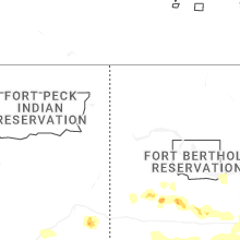


Connect with Interactive Hail Maps